Matijevic Hill detailed survey, Sol 3153 - 3290 |

  |
Matijevic Hill detailed survey, Sol 3153 - 3290 |
 Dec 7 2012, 07:19 PM Dec 7 2012, 07:19 PM
Post
#1
|
||
 Member  Group: Members Posts: 154 Joined: 19-September 12 Member No.: 6658 |
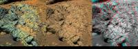
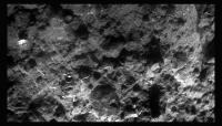
Some movement on sol 3153 to Copper Cliff:
Also visible in the Matijevic Pan. Finished watching the two videos posted above - very interesting stuff - Thanks stewjack for posting the links! |
|
 |
 
|
|
|
Dec 7 2012, 09:50 PM
Post
#2
|
|
|
Senior Member Group: Members Posts: 1045 Joined: 17-February 09 Member No.: 4605 |
Ronald, really nice presentation thank you. The choice of 3-d methods is very much appreciated.
|
|
|
|
|
Dec 10 2012, 03:34 PM
Post
#3
|
|||
|
Member Group: Members Posts: 154 Joined: 19-September 12 Member No.: 6658 |
Thanks
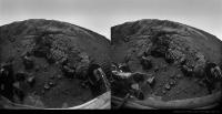
 A quick one for sol 3155:
|
||
|
|
|
||
|
Dec 10 2012, 05:19 PM
Post
#4
|
|
|
Senior Member Group: Moderator Posts: 4279 Joined: 19-April 05 From: .br at .es Member No.: 253 |
Use this thread for all images, discussions, etc. post sol 3153.
|
|
|
|
|
Dec 10 2012, 06:22 PM
Post
#5
|
||
 The Poet Dude Group: Moderator Posts: 5551 Joined: 15-March 04 From: Kendal, Cumbria, UK Member No.: 60 |
Really looking forward to Oppy getting stuck into the rocks here...
-------------------- |
|
|
|
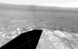
|
|
|
Dec 11 2012, 01:06 AM
Post
#6
|
|
|
Senior Member Group: Members Posts: 2998 Joined: 30-October 04 Member No.: 105 |
RE: the "NewBerries" discovered at this zone of the column:
QUOTE Impact spherules as a record of an ancient heavy bombardment of Earth Asteroids hitting Earth typically vaporize a mass of target rock comparable to the projectiles mass. As this vapour expands in a large plume or fireball, it cools and condenses into molten droplets called spherules. http://www.nature.com/nature/journal/v485/...ature10982.html  From my review of the literature and observations of the stratigraphy at the site, I am inclined to regard the "spherules of unknown affinity" simply as impact spherules. --Bill -------------------- |
|
|
|
|
Dec 11 2012, 06:13 PM
Post
#7
|
|
|
Member Group: Members Posts: 384 Joined: 4-January 07 Member No.: 1555 |
"Simply as impact spherules" may not be as simple as it sounds. Impacts can form spherule-like objects by multiple processes, including, e.g., condensation of silicate vapor to a glass, which you cited, condensation of sticky steam to mineral grains forming accretionary lapilli (e.g., the larger spherules stratigraphically associated with the Chicxulub Crater assumed to have killed the dinosaurs), hollow vesicles in impact glass later filled with minerals, or spherulites associated with devitrification (rapid partial crystallization) of impact glass (which spherulites characteristically have a radiating internal structure also noted at high magnification in some of the "newberries"). Multiple types of impact spherules might be expected to be preserved on Mars, much more commonly than on Earth, whose early impact record has been completely erased or is incomplete (biased by differential settling through sea water and heavily altered by aqueous processes).
-dburt |
|
|
|
|
Dec 11 2012, 08:25 PM
Post
#8
|
|
|
Member Group: Members Posts: 154 Joined: 19-September 12 Member No.: 6658 |
|
|
|
|
|
Dec 12 2012, 12:19 AM
Post
#9
|
|
|
Senior Member Group: Members Posts: 1045 Joined: 17-February 09 Member No.: 4605 |
The interesting aspect on the provenance of these new-berries is their position towards the bottom of the original crater rim. This seems a most unlikely position for deposition of lapilli or condensation spherules originating with the Endeavour impactor and provides an indication that this is part of the pre-impact surface / sub surface.
|
|
|
|
|
Dec 12 2012, 06:17 PM
Post
#10
|
||
|
The Poet Dude Group: Moderator Posts: 5551 Joined: 15-March 04 From: Kendal, Cumbria, UK Member No.: 60 |
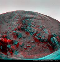
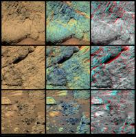
Opportunity MI mosaic...
-------------------- |
|
|
|
|
|
|
Dec 12 2012, 07:48 PM
Post
#11
|
||
|
Member Group: Members Posts: 154 Joined: 19-September 12 Member No.: 6658 |
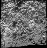
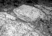
Some more Copper Cliff from sol 3156:
Could be a part of the Matijevic Hill Memory Game  Big version here. |
|
|
|
|
|
|
Dec 12 2012, 10:47 PM
Post
#12
|
|
 Member Group: Members Posts: 267 Joined: 5-February 06 Member No.: 675 |
QUOTE (Stu @ Dec 12 2012, 01:17 PM)  Opportunity MI mosaic... Very pretty. Do any of the resident geologists have an idea of what kinds of processes could have produced those fine veins in this rock? Steve M |
|
|
|
|
Dec 13 2012, 02:10 AM
Post
#13
|
|
|
Junior Member Group: Members Posts: 52 Joined: 1-March 11 From: Houston, USA Member No.: 5860 |
Fracturing followed by fluids depositing the white mineral in the fractures. Brecciation is common with impact. We saw similar fine veins near the south end of Cape York. Here's a link to a picture of a terrestrial breccia; different scale, fracturing mechanism, and fracture fill, but the filled fracture idea is the same:
http://www.nr.gov.nl.ca/nr/mines/outreach/.../breccia1lg.jpg |
|
|
|
|
Dec 13 2012, 02:28 AM
Post
#14
|
|
 Member Group: Members Posts: 399 Joined: 28-August 07 From: San Francisco Member No.: 3511 |
Does Vermilion look like a contact point between rock types that Steve Squyres alluded too in his recent AGU talk?
-------------------- 'She drove until the wheels fell off...'
|
|
|
|
|
Dec 14 2012, 07:00 AM
Post
#15
|
|
|
Senior Member Group: Members Posts: 1045 Joined: 17-February 09 Member No.: 4605 |
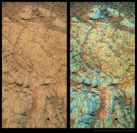
QUOTE (Stu @ Dec 10 2012, 07:22 PM) Really looking forward to Oppy getting stuck into the rocks here... Me too, although interpretation will be a nightmare. For instance the Copper Cliff MI pan shows glass, spherules, angular and rounded clasts, tiny veins and possibly a clast within a clast. While this is a polymictic impact product we cannot assume that the glass and spherules are cogenetic. Cape York is probably giving us an insight into the multiple impact products of the Hadean but our understanding will be through a glass darkly. |
|
|
|
|
Dec 14 2012, 07:39 AM
Post
#16
|
|||
|
Newbie Group: Members Posts: 14 Joined: 7-August 12 From: California Member No.: 6489 |
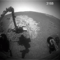
QUOTE (Stu @ Dec 12 2012, 11:17 AM) Opportunity MI mosaic...
In this version of MI 3158 I rotated the mosaic 180 degrees just for familiar shadow angle.
|
||
|
|
|
||
|
Dec 14 2012, 01:29 PM
Post
#17
|
|
|
Member Group: Members Posts: 282 Joined: 18-June 04 Member No.: 84 |
Looks like there is a bit of everything mixed up in that rock

|
|
|
|
|
Dec 20 2012, 12:20 PM
Post
#18
|
|
|
Member Group: Members Posts: 913 Joined: 4-September 06 From: Boston Member No.: 1102 |
The forgotten rover is still keeping busy. From JPL
Shoulder Work At 'Copper Cliff' Opportunity Status for sol 3159-3165 Release Date: 12/19/12 Opportunity is working at "Matijevic Hill" (named in honor of Jake Matijevic) at the inboard edge of "Cape York" on the rim of Endeavour Crater. There, the rover has been conducting in-situ (contact) science measurements at a location called "Copper Cliff." On Sol 3160 (Dec. 13, 2012), Opportunity began taking images with its Microscopic Imager (MI) for a mosaic of a surface target. Partway through the activity, the rover's robotic arm experienced a stall in the shoulder azimuth joint. This has been seen a few times before when the arm is commanded to move at a slow rate, but not the slowest rate. Magnetic detents normally hold the motor armature when unpowered, and under certain slow-rate conditions they are able to restrain the armature from spinning. At higher rates, the armature has enough momentum to keep spinning, while at the slowest rates a higher stall threshold is used. Activities on Sol 3162 (Dec. 15, 2012) confirmed the joint is OK, and an offset placement of the Alpha Particle X-ray Spectrometer (APXS) was completed. On Sol 3165 (Dec. 18, 2012), Opportunity bumped about 18 feet (5.5 meters) to the west to reach a new set of surface targets in this Copper Cliff area. The rover will likely continue in-situ investigations in the area through the coming holiday. As of Sol 3165, the solar array energy production was 533 watt-hours with an increased atmospheric opacity (Tau) of 0.955 and a solar array dust factor of 0.607. Total odometry is 22.02 miles (35438.37 meters) Image of Copper Cliff area -------------------- |
|
|
|
|
Dec 20 2012, 10:34 PM
Post
#19
|
||
|
Member Group: Members Posts: 154 Joined: 19-September 12 Member No.: 6658 |
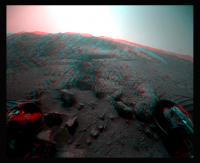
QUOTE (Floyd @ Dec 20 2012, 01:20 PM) The forgotten rover Naaaaa Vermilion again - sol 3165:
|
|
|
|
|
|
|
Dec 22 2012, 09:06 AM
Post
#20
|
||
 Member Group: Members Posts: 691 Joined: 21-December 07 From: Clatskanie, Oregon Member No.: 3988 |
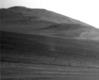
I wasn't going to add this here, because I made this for my Facebook Banner, but I'll post it anyway's.
|
|
|
|
|
|
|
Jan 1 2013, 06:02 PM
Post
#21
|
||
 Senior Member Group: Members Posts: 4252 Joined: 17-January 05 Member No.: 152 |
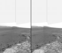
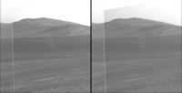
Some changes visible between sols 3168 and 3177, probably due to dust blown by wind:
They're not due to lighting differences, since the local times of the two frames differ by only a few minutes. Gusts are always welcome... |
|
|
|
|
|
|
Jan 2 2013, 08:48 PM
Post
#22
|
|
 Member Group: Members Posts: 495 Joined: 12-February 12 Member No.: 6336 |
QUOTE (fredk @ Jan 1 2013, 07:02 PM) They're not due to lighting differences, since the local times of the two frames differ by only a few minutes. Gusts are always welcome... Good find, and yes Gusts of wind are very much welcome for Opportunity. |
|
|
|
|
Jan 4 2013, 03:31 PM
Post
#23
|
|
|
Senior Member Group: Members Posts: 4252 Joined: 17-January 05 Member No.: 152 |
Sure enough, we did have a cleaning event, on sol 3175, according to the latest update.
|
|
|
|
|
Jan 5 2013, 07:13 PM
Post
#24
|
||
|
Senior Member Group: Members Posts: 4252 Joined: 17-January 05 Member No.: 152 |
And we are back at Whitewater Lake:
http://qt.exploratorium.edu/mars/opportuni...0M1.JPG?sol3182 You can see the grind mark (circled):
|
|
|
|
|
|
|
Jan 5 2013, 07:37 PM
Post
#25
|
|
 Senior Member Group: Moderator Posts: 3431 Joined: 11-August 04 From: USA Member No.: 98 |
Hey, you're right! I was wondering where those tracks came from.
 MERBSol3182BackAtWhitewaterLake, on Flickr |
|
|
|
|
Jan 9 2013, 02:13 AM
Post
#26
|
|
 Member Group: Members Posts: 100 Joined: 20-January 06 Member No.: 652 |
-------------------- |
|
|
|
|
Jan 9 2013, 02:36 AM
Post
#27
|
|
|
Merciless Robot Group: Admin Posts: 8784 Joined: 8-December 05 From: Los Angeles Member No.: 602 |
A.J.S. Rayl just plain does it right.
And a big shout-out to our own Stu & Tesheiner for their featured contributions to this excellent article!
-------------------- A few will take this knowledge and use this power of a dream realized as a force for change, an impetus for further discovery to make less ancient dreams real.
|
|
|
|
|
Jan 9 2013, 03:23 AM
Post
#28
|
|
|
Senior Member Group: Moderator Posts: 3431 Joined: 11-August 04 From: USA Member No.: 98 |
That's a particularly blockbuster report. Really striking for the collaboration between MER and MRO to reach any conclusions. Makes me wonder: if Opportunity were parked over, say, Whitewater Lake, would that be detectable to CRISM?
|
|
|
|
|
Jan 9 2013, 08:28 PM
Post
#29
|
|
|
Senior Member Group: Moderator Posts: 4279 Joined: 19-April 05 From: .br at .es Member No.: 253 |
Opportunity did a small bump to the right on sol 3185, and Whitewater Lake is now dead center ahead of the IDD workvolume.

|
|
|
|
|
Jan 10 2013, 05:33 PM
Post
#30
|
|
|
Junior Member Group: Members Posts: 30 Joined: 6-September 12 From: Denver Member No.: 6641 |
With what is going on with Curiousity, I sometimes forget the amazing landscape that Opportunity is roving in.
Go Opportunity!! 
|
|
|
|
|
Jan 14 2013, 08:50 PM
Post
#31
|
|||
|
Senior Member Group: Moderator Posts: 3431 Joined: 11-August 04 From: USA Member No.: 98 |
Was poking around and just now noticed this: dust devil on sol 3182. (Center frame; vertical line is south).
Attached thumbnail(s)
|
||
|
|
|
||
|
Jan 14 2013, 09:12 PM
Post
#32
|
|
|
The Poet Dude Group: Moderator Posts: 5551 Joined: 15-March 04 From: Kendal, Cumbria, UK Member No.: 60 |
Well spotted.
-------------------- |
|
|
|
|
Jan 14 2013, 09:28 PM
Post
#33
|
||
|
Senior Member Group: Members Posts: 4252 Joined: 17-January 05 Member No.: 152 |
Yeah, nice catch! That's only DD#2 for Oppy, IIRC.
Here's a stacked average of the L and R frames:
If anyone's skeptical, it appears in exactly the same spot in the L and R frames, but is completely absent from the neighbouring frames, taken less than a minute earlier: http://marsrovers.jpl.nasa.gov/gallery/all...__P0675R0M1.JPG |
|
|
|
|
|
|
Jan 14 2013, 09:50 PM
Post
#34
|
|
|
Member Group: Members Posts: 866 Joined: 15-March 05 From: Santa Cruz, CA Member No.: 196 |
hmmm, yeah and If I Searched Correctly, there was only DD#1 in an old FredK post and gif animation from way back in 2010 SOL 2301 ...
also in the center left of ant103's pano |
|
|
|
|
Jan 14 2013, 10:08 PM
Post
#35
|
|||
|
Senior Member Group: Moderator Posts: 3431 Joined: 11-August 04 From: USA Member No.: 98 |
Good point, Fred - right in the overlap area. Here's two frames if anyone wants to make a flicker animation - seems to be beyond my technical ability at the moment. (Disclaimer: contains my own inexact de-vignetting and brightness adjustment.)
Attached thumbnail(s)
|
||
|
|
|
||
|
Jan 14 2013, 10:35 PM
Post
#36
|
|
|
Solar System Cartographer Group: Members Posts: 10186 Joined: 5-April 05 From: Canada Member No.: 227 |
Great observation!
Phil -------------------- ... because the Solar System ain't gonna map itself.
Also to be found posting similar content on https://mastodon.social/@PhilStooke Maps for download (free PD: https://upload.wikimedia.org/wikipedia/comm...Cartography.pdf NOTE: everything created by me which I post on UMSF is considered to be in the public domain (NOT CC, public domain) |
|
|
|
|
Jan 14 2013, 11:36 PM
Post
#37
|
|||
|
Senior Member Group: Members Posts: 4252 Joined: 17-January 05 Member No.: 152 |
QUOTE (mhoward @ Jan 14 2013, 10:08 PM) Here's two frames if anyone wants to make a flicker animation Here you go:
And here's the difference, with DD minus without DD:
Heavy jpeg artifacts at this zoom and stretch, but in all cases I've averaged the L and R frames to boost S/N by sqrt(2). |
||
|
|
|
||
|
Jan 15 2013, 12:26 AM
Post
#38
|
|
|
Member Group: Members Posts: 866 Joined: 15-March 05 From: Santa Cruz, CA Member No.: 196 |
so are entering into dust devil season?
if the last sighting was SOL 2301 and now its SOL 3182 it looks like were at least a season ahead of the last cycle sighting, any seasonal pattern to this? lets see.. Last DD was seen about the middle between Mars summer solstice and autumnal equinox.. This one has Mars' winter solstice is coming up this Feb 23 2013. if these two are just outliers i guess we have'nt been paying attention.. |
|
|
|
|
Jan 15 2013, 01:17 AM
Post
#39
|
|
 Senior Member Group: Members Posts: 3419 Joined: 9-February 04 From: Minneapolis, MN, USA Member No.: 15 |
I'm not surprised we're seeing a DD here. The relative lack of them at Meridiani is, I think, due to the lack of pronounced hills and slopes in the area. DDs seem to spawn off of hills and out of very large craters. We have the kinds of slopes required to generate them at our current location, but haven't seen much in the way of hills up until now.
-the other Doug -------------------- The trouble ain't that there is too many fools, but that the lightning ain't distributed right. -Mark Twain
|
|
|
|
|
Jan 17 2013, 08:51 AM
Post
#40
|
||
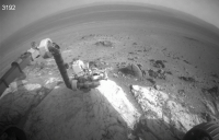
 Member Group: Members Posts: 404 Joined: 5-January 10 Member No.: 5161 |
That dust devil was a treat!
Haven't done one of these for awhile, did my best taking out the headaches. Micro from Sol 3192:
|
|
|
|
|
|
|
Jan 17 2013, 04:11 PM
Post
#41
|
|
|
Senior Member Group: Members Posts: 4252 Joined: 17-January 05 Member No.: 152 |
Beautiful! I love those micro-buttes.
|
|
|
|
|
Jan 17 2013, 05:45 PM
Post
#42
|
|
|
Solar System Cartographer Group: Members Posts: 10186 Joined: 5-April 05 From: Canada Member No.: 227 |
Yes, they're beauts.
Phil MOD NOTE: In an unprecedented admin/mod team action, Phil will presently be executed for this... 
-------------------- ... because the Solar System ain't gonna map itself.
Also to be found posting similar content on https://mastodon.social/@PhilStooke Maps for download (free PD: https://upload.wikimedia.org/wikipedia/comm...Cartography.pdf NOTE: everything created by me which I post on UMSF is considered to be in the public domain (NOT CC, public domain) |
|
|
|
|
Jan 17 2013, 09:30 PM
Post
#43
|
|
|
Senior Member Group: Members Posts: 3419 Joined: 9-February 04 From: Minneapolis, MN, USA Member No.: 15 |
Groannnnnnnnnnnnnn.....
-the other Doug -------------------- The trouble ain't that there is too many fools, but that the lightning ain't distributed right. -Mark Twain
|
|
|
|
|
Jan 18 2013, 03:03 AM
Post
#44
|
|
|
Member Group: Members Posts: 399 Joined: 28-August 07 From: San Francisco Member No.: 3511 |
How Dajare You...
-------------------- 'She drove until the wheels fell off...'
|
|
|
|
|
Jan 18 2013, 05:20 AM
Post
#45
|
|||
|
Senior Member Group: Members Posts: 4252 Joined: 17-January 05 Member No.: 152 |
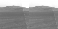
More wind action at Endeavour - what looks like a gust well inside the crater on sol 3194, arrowed:
More changes are visible in the foreground, and very easy to see when you take the difference between the two frames:
The two frames are only a few minutes apart in local time, so the lighting is almost identical. The gust is not visible in the frames taken just after the 3194 frames: http://qt.exploratorium.edu/mars/opportuni...0M1.JPG?sol3194 |
||
|
|
|
||
|
Jan 18 2013, 11:39 PM
Post
#46
|
|
|
Senior Member Group: Members Posts: 4252 Joined: 17-January 05 Member No.: 152 |
This has got to be a record - pics from sol 882 down today, that's 6 1/2 years ago!
http://qt.exploratorium.edu/mars/opportuni...2M2.JPG?sol---- That was by Beagle Crater, which a few of the oldtimers may recall was just before Victoria... Edit - that frame was already in the PDS (but not the jpl jpeg site), so it must just be some pipeline thing. Still funny to see... |
|
|
|
|
Jan 18 2013, 11:57 PM
Post
#47
|
|
|
Senior Member Group: Moderator Posts: 3431 Joined: 11-August 04 From: USA Member No.: 98 |
Yeah, a blast from the past.
Those images were trickling in so slowly today, it certainly seemed as if they were coming through the normal pipeline.
|
|
|
|
|
Jan 19 2013, 09:13 AM
Post
#48
|
|
|
Senior Member Group: Moderator Posts: 4279 Joined: 19-April 05 From: .br at .es Member No.: 253 |
Robot dreams maybe?
|
|
|
|
|
Jan 19 2013, 07:08 PM
Post
#49
|
|
|
Founder Group: Chairman Posts: 14433 Joined: 8-February 04 Member No.: 1 |
QUOTE (fredk @ Jan 18 2013, 03:39 PM) Edit - that frame was already in the PDS (but not the jpl jpeg site), so it must just be some pipeline thing. Still funny to see... It's a Version 2 of the image, so maybe a backed up downlink or ground processing thing. |
|
|
|
|
Jan 23 2013, 08:05 AM
Post
#50
|
||
|
Member Group: Members Posts: 404 Joined: 5-January 10 Member No.: 5161 |
A micro from Sol 3194:
|
|
|
|
|
|
|
Jan 29 2013, 01:53 PM
Post
#51
|
||
|
Senior Member Group: Moderator Posts: 4279 Joined: 19-April 05 From: .br at .es Member No.: 253 |
Everyone, wakeup! Nobody noticed that two days ago Opportunity left the site she was investigating for the last couple of weeks?
Here's a navcam mosaic taken on sol 3203; we're already on sol 3205.
|
|
|
|
|
|
|
Jan 29 2013, 02:15 PM
Post
#52
|
|
|
Senior Member Group: Moderator Posts: 3431 Joined: 11-August 04 From: USA Member No.: 98 |
Some of us noticed
Oppy's now back at "Broken Hammer," previously visited sols 3098-3101.Here's a view of drive north on sol 3203 (blue line) based on the metadata (vertical line is north):  
|
|
|
|
|
Jan 29 2013, 03:31 PM
Post
#53
|
|
|
Senior Member Group: Members Posts: 4252 Joined: 17-January 05 Member No.: 152 |
And a further bump north on 3205:
http://qt.exploratorium.edu/mars/opportuni...0M1.JPG?sol3205 |
|
|
|
|
Jan 29 2013, 04:36 PM
Post
#54
|
|
|
Senior Member Group: Moderator Posts: 3431 Joined: 11-August 04 From: USA Member No.: 98 |
|
|
|
|
|
Jan 30 2013, 07:05 PM
Post
#55
|
|
|
Senior Member Group: Members Posts: 4252 Joined: 17-January 05 Member No.: 152 |
Further short drive on 3206:
http://qt.exploratorium.edu/mars/opportuni...0M1.JPG?sol3206 |
|
|
|
|
Jan 30 2013, 09:13 PM
Post
#56
|
|
|
Senior Member Group: Moderator Posts: 3431 Joined: 11-August 04 From: USA Member No.: 98 |
Interesting - the sol 3206 drive was westward back to "Flack Lake".
 
|
|
|
|
|
Jan 31 2013, 08:23 AM
Post
#57
|
||
|
Member Group: Members Posts: 404 Joined: 5-January 10 Member No.: 5161 |
A micro from Sol 3200 that actually lines up to one side of the micro from Sol 3192. Might try to stitch them later.
There's some doubling up of features at the mid-seam, still learning some tricks to line things up better. (Edit: The above image will line up with the one from Sol 3192 if it's rotated 180°. Sometimes I don't know which way is "up"! By the way, Photoshop refuses to auto-stitch these two latest micros with the ones from 3192. Would have to do it manually.  ) )
|
|
|
|
|
|
|
Feb 1 2013, 01:34 AM
Post
#58
|
|
|
Senior Member Group: Members Posts: 2998 Joined: 30-October 04 Member No.: 105 |
LPSC-44:
44th Lunar and Planetary Science Conference (2013) sess252.pdf Tuesday, March 19, 2013 [T252] MARS EXPLORATION ROVER: RESULTS FROM ENDEAVOUR CRATER http://www.lpi.usra.edu/meetings/lpsc2013/pdf/sess252.pdf --Bill -------------------- |
|
|
|
|
Feb 1 2013, 04:02 PM
Post
#59
|
|
|
Senior Member Group: Members Posts: 4252 Joined: 17-January 05 Member No.: 152 |
In Fig 2 of this abstract we finally can see the high-resolution CRISM view of the smectite signature on Matijevic Hill. It would be interesting to see that overlaid on a good quality map, but the background in that image is very low resolution so it would be hard to do.
|
|
|
|
|
Feb 1 2013, 10:19 PM
Post
#60
|
|
|
Senior Member Group: Members Posts: 1045 Joined: 17-February 09 Member No.: 4605 |
Dear me. That smectite location is nothing like the numerous, previous CRISM overlays published in papers and articles. Previously I couldn't understand reference to Opportunity being 'in the sweet spot' - for instance:
http://www.planetary.org/explore/space-top...ck-on-2012.html Does this mean that the previous indications of extensive smectite indications to the south are exaggerated and that the smectites are more localised? |
|
|
|
|
Feb 1 2013, 10:45 PM
Post
#61
|
|
|
Senior Member Group: Members Posts: 3516 Joined: 4-November 05 From: North Wales Member No.: 542 |
I think that is just an overlay of the Whitewater Lake exposure as seen by the rover on a background Crism image. I don't think this is a Crism image that in itself delineates the smectite exposure in an obvious way. (The overlay has much higher resolution than the background, and much higher resolution than Crism.)
|
|
|
|
|
Feb 2 2013, 03:06 AM
Post
#62
|
|
|
Senior Member Group: Members Posts: 2998 Joined: 30-October 04 Member No.: 105 |
Could be most anywhere in this area-- the CRISM res is so low.
I want to see "Secular City" next door... --Bill -------------------- |
|
|
|
|
Feb 2 2013, 07:58 PM
Post
#63
|
|
|
Member Group: Members Posts: 384 Joined: 4-January 07 Member No.: 1555 |
QUOTE (Bill Harris @ Jan 31 2013, 06:34 PM) 44th Lunar and Planetary Science Conference (2013), sess 252 MARS EXPLORATION ROVER: RESULTS FROM ENDEAVOUR CRATER http://www.lpi.usra.edu/meetings/lpsc2013/pdf/sess252.pdf --Bill Thanks much for that link. Some of the abstracts make it appear that the devitrification spherulite idea for "newberries," first debated here on UMSF, is gaining traction. In that regard, I found this abstract, from a different session, interesting also: http://www.lpi.usra.edu/meetings/lpsc2013/pdf/2064.pdf It begins with "Blueberries, newberries, and accretionary lapilli..." and describes gray-hematite coated basaltic accretionary lapilli, about 7 mm in diameter, resulting from explosive volcanism in Antarctica, including in basal surge beds that are said to mimic fluvial or eolian beds. For purposes of comparison, keep in mind that martian basalts are probably considerably more iron rich and less silicic than the ones from Antarctica. -dburt |
|
|
|
|
Feb 3 2013, 12:12 AM
Post
#64
|
|
|
Senior Member Group: Members Posts: 2998 Joined: 30-October 04 Member No.: 105 |
And thanks for the "Newberries" PDF. That Mt Darwin photo looks almost... Martian. And in keeping with Martian environments, remember that Antarctica wasn't always as it is today.
This will prove to be a great LPSC, with the detailed work at Cape York and the initial work at Gale. And I wouldn't be surprised if we start seeing "hey, I just noticed this at Gusev" from old Spirit data. The Gifts that Keep on Giving, no? --Bill -------------------- |
|
|
|
|
Feb 3 2013, 01:24 AM
Post
#65
|
|
|
Senior Member Group: Members Posts: 4252 Joined: 17-January 05 Member No.: 152 |
QUOTE (ngunn @ Feb 1 2013, 11:45 PM) I think that is just an overlay of the Whitewater Lake exposure as seen by the rover on a background Crism image. I don't think this is a Crism image that in itself delineates the smectite exposure in an obvious way. (The overlay has much higher resolution than the background, and much higher resolution than Crism.) I wondered about that myself. But the text says QUOTE Results showed the presence of the two longer wavelength bands... for the locations mapped in Fig. 2 and the Fig 2 caption saysQUOTE The red area with the smectite signature corresponds to Whitewater Lake outcrops. Both statements indicate that the red area was determined by the CRISM data rather than ground (or orbital) imagery.About the resolution, the abstract says the regular resolution is 18 m/px. This seems to correspond to the resolution of most of Fig 2. But the text also describes the oversampled, higher resolution CRISM observations, with 5 m/px resolution. That seems to match pretty well the size of the pixels in the red, smectite patch in Fig 2. So my interpretation is that the red area is the set of pixels with smectite signature from the 5 m/px observations, overlaid on the regular resolution CY CRISM image. We may have to wait for a full paper to come out to know for sure. |
|
|
|
|
Feb 3 2013, 03:29 AM
Post
#66
|
|
|
Solar System Cartographer Group: Members Posts: 10186 Joined: 5-April 05 From: Canada Member No.: 227 |
Not sure about this... to me it looks like the very dark blue background is supposed to be the clay - the largest area being at the south end where older observations placed it and the original reason for going to the south end first. A smaller patch of dark blue under that red patch is the CRISM detection in that area and the red is an overlay of the Whitewater unit as mapped by the rover, showing the spatial match.
But we'll have to wait and see. I will be looking out for this at LPSC. Phil -------------------- ... because the Solar System ain't gonna map itself.
Also to be found posting similar content on https://mastodon.social/@PhilStooke Maps for download (free PD: https://upload.wikimedia.org/wikipedia/comm...Cartography.pdf NOTE: everything created by me which I post on UMSF is considered to be in the public domain (NOT CC, public domain) |
|
|
|
|
Feb 3 2013, 06:01 AM
Post
#67
|
|
|
Senior Member Group: Members Posts: 4252 Joined: 17-January 05 Member No.: 152 |
I think you may be right, Phil. Fig 3 is an average over all the pixels in the red area. It would seem surprizing that there'd be enough S/N in each individual pixel to define the red area that precisely based on the CRISM data.
|
|
|
|
|
Feb 3 2013, 03:28 PM
Post
#68
|
|
|
Senior Member Group: Members Posts: 2998 Joined: 30-October 04 Member No.: 105 |
QUOTE (Bill Harris @ Feb 1 2013, 10:06 PM) Could be most anywhere in this area-- the CRISM res is so low. And I'd really like to see what is in the region lower down on the Bench to the NE. Stratigraphically lower, older in time, further back into the "warmer wetter" era. Probably more of the impactite/ejectite sequence, but we won't know til we look.I want to see "Secular City" next door... --Bill --Bill -------------------- |
|
|
|
|
Feb 5 2013, 05:32 PM
Post
#69
|
||
|
Senior Member Group: Moderator Posts: 4279 Joined: 19-April 05 From: .br at .es Member No.: 253 |
There was a quite long drive executed today, sol 3212, placing Opportunity almost at the same site as on sol 3104.
Here's today's navcam mosaic.
And here is the one shot on sol 3104. |
|
|
|
|
|
|
Feb 6 2013, 03:07 AM
Post
#70
|
|
|
Member Group: Members Posts: 866 Joined: 15-March 05 From: Santa Cruz, CA Member No.: 196 |
QUOTE (fredk @ Jan 18 2013, 03:39 PM) This has got to be a record - pics from sol 882 down today, that's 6 1/2 years ago! http://qt.exploratorium.edu/mars/opportuni...2M2.JPG?sol---- That was by Beagle Crater, which a few of the oldtimers may recall was just before Victoria... catching up on old news here.. remarkably uncanny image! by chance a recent movie rental stuck in my head makes me i see 'engineer helmet'! evoking schlock-fodder from the lower left of that old Spirit image! (sorry, but had to.. resistance was futile) |
|
|
|
|
Feb 6 2013, 06:13 AM
Post
#71
|
|
|
Senior Member Group: Members Posts: 2998 Joined: 30-October 04 Member No.: 105 |
QUOTE remarkably uncanny image! I've been meaning to drop into the archives and look at images and notes from that timespot. Seems that I recall that Beagle was post-Victoria ejecta blanket and uncovered interactions between the ejecta and the paleo landsurface. And there were a few odd hillocks observed as we transitioned from the typical Meridiani surface to the weathered/eroded/weathered Victoria ejecta material.MERs. The gift that keeps on giving. --Bill -------------------- |
|
|
|
|
Feb 6 2013, 08:12 AM
Post
#72
|
||
|
Member Group: Members Posts: 404 Joined: 5-January 10 Member No.: 5161 |
Quite the protruding newberries, really fantastic structures, from sol 3207:
|
|
|
|
|
|
|
Feb 6 2013, 08:23 AM
Post
#73
|
||
|
Member Group: Members Posts: 404 Joined: 5-January 10 Member No.: 5161 |
Another one with more consistent lighting also from Sol 3207. This micro overlaps the previous one I just posted:
|
|
|
|
|
|
|
Feb 7 2013, 02:46 AM
Post
#74
|
|
 Senior Member Group: Members Posts: 2228 Joined: 1-December 04 From: Marble Falls, Texas, USA Member No.: 116 |
QUOTE (walfy @ Feb 6 2013, 02:12 AM) Quite the protruding newberries, really fantastic structures, from sol 3207... Beautiful, but can we cut with the formalities and just call them newbs?  -------------------- ...Tom
I'm not a Space Fan, I'm a Space Exploration Enthusiast. |
|
|
|
|
Feb 7 2013, 03:51 AM
Post
#75
|
|
|
Senior Member Group: Members Posts: 1045 Joined: 17-February 09 Member No.: 4605 |
Or newbys?
|
|
|
|
|
Feb 7 2013, 05:22 AM
Post
#76
|
|
|
Senior Member Group: Members Posts: 4252 Joined: 17-January 05 Member No.: 152 |
Some discussion of future plans in the latest PS report:
QUOTE Solander Point would be an ideal place for Opportunity to winter... "There are meters and meters of stratigraphic section there, a much thicker stratigraphic section of this ancient Noachian crust. And the cool thing is that it's all tilted north. So we can have a great time crawling around on the northerly slope and not be immobile for the winter."
In addition, the trek across Botany Bay promises more scientific treasures on the way to Solander Point. "There are large exposures gypsum we think, based on CRISM data, not as veins but as bedrock," said Arvidson... "So we may be driving across Botany Bay to find the lowest part of the Burns Formation exposed." |
|
|
|
|
Feb 7 2013, 07:55 AM
Post
#77
|
||
|
Member Group: Members Posts: 404 Joined: 5-January 10 Member No.: 5161 |
I quick GIF of sol 3208 and 3209 micros. Each one is a stitch of 4 images, so not the best of lining everything up between sols, did the best I could under time constraints and in need of more Photoshop lessons!
|
|
|
|
|
|
|
Feb 7 2013, 08:05 AM
Post
#78
|
||
|
Member Group: Members Posts: 404 Joined: 5-January 10 Member No.: 5161 |
Oppy picking newberries, closeup view:
|
|
|
|
|
|
|
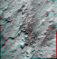
Feb 8 2013, 01:43 AM
Post
#79
|
||
|
Member Group: Members Posts: 866 Joined: 15-March 05 From: Santa Cruz, CA Member No.: 196 |
some newbie (SOL 3207) fun with Gimp (tried to minimize shadow) and StereoPhotoMaker:
|
|
|
|
|
|
|
Feb 8 2013, 05:08 AM
Post
#80
|
||
|
Member Group: Members Posts: 404 Joined: 5-January 10 Member No.: 5161 |
Nice patterns in the sand, nice view, makes for a good composition!
|
|
|
|
|
|
|
Feb 8 2013, 05:41 AM
Post
#81
|
|
|
Senior Member Group: Members Posts: 4252 Joined: 17-January 05 Member No.: 152 |
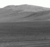
It is a nice view! Surprizingly the tracks on the left, from sol 3104, don't look very different from the new ones on the right, from 3212. At least from this angle and using navcam.
|
|
|
|
|
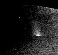
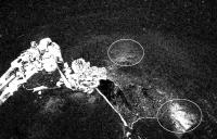
Feb 12 2013, 08:22 AM
Post
#82
|
||
|
Member Group: Members Posts: 404 Joined: 5-January 10 Member No.: 5161 |
Another nice micro of late, Sol 3214.
Had to reduce the size to meet upload limitation, need to find some place online to post full res size, minimal compression. |
|
|
|
|
|
|
Feb 12 2013, 08:08 PM
Post
#83
|
||
|
Senior Member Group: Members Posts: 4252 Joined: 17-January 05 Member No.: 152 |
Looks like a new DD for Oppy, peeking out from behind the central mound:
http://qt.exploratorium.edu/mars/opportuni...0M1.JPG?sol3219 Edit: blink comparison with sol 3214, making it easy to see the DD:
It has to be very big, because it's a long way to the central mound. 
|
|
|
|
|
|
|
Feb 12 2013, 08:43 PM
Post
#84
|
|
|
Solar System Cartographer Group: Members Posts: 10186 Joined: 5-April 05 From: Canada Member No.: 227 |
Nice one, Fredk! Isn't it in the crater floor near the south end of the mound rather than "peeking out from behind the central mound" ? But yes, it must be quite a big one.
Phil -------------------- ... because the Solar System ain't gonna map itself.
Also to be found posting similar content on https://mastodon.social/@PhilStooke Maps for download (free PD: https://upload.wikimedia.org/wikipedia/comm...Cartography.pdf NOTE: everything created by me which I post on UMSF is considered to be in the public domain (NOT CC, public domain) |
|
|
|
|
Feb 16 2013, 10:52 PM
Post
#85
|
|
 Senior Member Group: Members Posts: 2492 Joined: 15-January 05 From: center Italy Member No.: 150 |
Can someone explain me (here or in another appropriate thread) why they decided to repeat exactly the same loop after 3.5 months instead to go toward Solander or other interesting places? Thanks!
Added: perhaps I found by myself the answer! from Squyres words reported in Dec,4 update, QUOTE Opportunity drove about 1,160 feet (354 meters) in a counterclockwise circuit around Matijevic Hill in October and November, bringing the total miles driven on the mission to 22 miles (35.4 kilometers). Researchers used the rover to survey the extent of Matijevic Hill outcrops and identify the best places to investigate further. "We've got a list of questions posed by the observations so far," Squyres said. "We did this walkabout to determine the most efficient use of time to answer the questions. Now we have a good idea what we're dealing with, and we're ready to start the detailed work."
-------------------- I always think before posting! - Marco -
|
|
|
|
|
Feb 16 2013, 11:58 PM
Post
#86
|
|
|
Merciless Robot Group: Admin Posts: 8784 Joined: 8-December 05 From: Los Angeles Member No.: 602 |
it's obviously a tremendously interesting site, and I'm gonna guess that they think that it's also representatve of the entire crater rim. Therefore, there wouldn't be much point in mounting a lengthy traverse to a geologically similar locale till they've wrung as much data out of here as they can.
-------------------- A few will take this knowledge and use this power of a dream realized as a force for change, an impetus for further discovery to make less ancient dreams real.
|
|
|
|
|
Feb 17 2013, 02:59 AM
Post
#87
|
|
 Member Group: Members Posts: 754 Joined: 9-February 07 Member No.: 1700 |
There are several layers of Mars history right there, I hadn't thought of it with the awareness of a geologist. I keep thinking "drive! drive!" lol
|
|
|
|
|
Feb 17 2013, 06:42 AM
Post
#88
|
|
|
Senior Member Group: Members Posts: 2492 Joined: 15-January 05 From: center Italy Member No.: 150 |
Yes, I must force myself to recall that main purpose of MER mission is geologic survey and not establish new drive records nor take breathtaking panoramas of new places... It's hard to accept such philosphy after many years of spectacular views!
To moderators: Sorry for the OT, I'll stop immediately this argument because I know isn't the purpose of this thread! Mod: moved the discussion to the main thread. -------------------- I always think before posting! - Marco -
|
|
|
|
|
Feb 17 2013, 10:44 AM
Post
#89
|
|
|
Senior Member Group: Moderator Posts: 4279 Joined: 19-April 05 From: .br at .es Member No.: 253 |
You may have a look to the latest (Feb 06th) report by AJS Rayl too. Here's a paragraph talking about the current survey.
QUOTE In coming sols, once Opportunity completes its study of the spherules - "which will take a while," said Arvidson - the rover may then be directed to go in search of that main contact or boundary line between the older Kirkwood/Whitewater Lake/ Copper Cliff bedrock and what the scientists believe is the overlying Shoemaker Formation. "We don't know exactly where the contact is other than it's gotta be uphill," said Arvidson.
|
|
|
|
|
Mar 6 2013, 04:35 PM
Post
#90
|
|
|
Senior Member Group: Members Posts: 4252 Joined: 17-January 05 Member No.: 152 |
Lots of interesting detail in the latest PS report. On future plans:
QUOTE Squyres: "we're going to do a little light RAT grind into a dense concentration of newberries and we're going to take a pic of the cuttings with Pancam and we'll see what we see. It's a streak test." QUOTE The current hope is for Opportunity to wrap-up work on Matijevic Hill in the next couple of weeks, depart Cape York and be roving southward to Solander Point no later than May 9th, where - if everything goes as hoped - the rover will spend the next Martian winter. The ninth of May is the "last possible date" that Opportunity can leave Cape York and get to Solander Point "safely and with plenty of margin," according to John Callas And the recent silence was due to another flash fault, coincidentally timed with MSL's: QUOTE sol, 3235... she experienced another "amnesia" event or fault in her Flash memory... according to Stroupe. "The rover is fine," she added. "We're just set back a couple of days."
"The fix is to reformat the Flash and that's what we did on Spirit, but the problem is it's intermittent," Nelson reiterated from last month. "So, if at the time you do the reformatting that troublesome sector is working just fine, then even after reformatting it will continue to fail because the software didn't read it as bad," he explained. It has to get really bad before we can reformat the Flash successfully." |
|
|
|
|
Mar 6 2013, 06:35 PM
Post
#91
|
|
|
Senior Member Group: Moderator Posts: 4279 Joined: 19-April 05 From: .br at .es Member No.: 253 |
That's music to my ears! 
|
|
|
|
|
Mar 7 2013, 05:24 AM
Post
#92
|
|
|
Senior Member Group: Members Posts: 2228 Joined: 1-December 04 From: Marble Falls, Texas, USA Member No.: 116 |
QUOTE (fredk @ Mar 6 2013, 10:35 AM) Lots of interesting detail in the latest PS report. ... Many thanks, fredk, for your always-excellent selection of the key pieces of news from Salley's also-outstanding updates. It'll be exciting to be roving again.  ...and now, Opportunity gets to climb a mountain as her sister did... -------------------- ...Tom
I'm not a Space Fan, I'm a Space Exploration Enthusiast. |
|
|
|
|
Mar 7 2013, 05:53 AM
Post
#93
|
|
|
Senior Member Group: Members Posts: 2228 Joined: 1-December 04 From: Marble Falls, Texas, USA Member No.: 116 |
fredk: I had to also add that there is this interesting piece of information from one of your earlier update summaries...
QUOTE In addition, the trek across Botany Bay promises more scientific treasures on the way to Solander Point. "There are large exposures (of) gypsum we think, based on CRISM data, not as veins but as bedrock," said Arvidson... "So we may be driving across Botany Bay to find the lowest part of the Burns Formation exposed." I am excited to think about the possibility of that stratigraphic exposure.
-------------------- ...Tom
I'm not a Space Fan, I'm a Space Exploration Enthusiast. |
|
|
|
|
Mar 7 2013, 01:30 PM
Post
#94
|
|
|
Senior Member Group: Moderator Posts: 3431 Joined: 11-August 04 From: USA Member No.: 98 |
By the way, yestersol (3240) she drove south to the area below Kirkwood. The Update mentions she might conduct the very cool streak test at "Kirkwood or a place like Kirkwood".
|
|
|
|
|
Mar 7 2013, 05:59 PM
Post
#95
|
||
|
Senior Member Group: Moderator Posts: 4279 Joined: 19-April 05 From: .br at .es Member No.: 253 |
Exactly. Here's the navcam mosaic shot after the drive. The rover is right on top of some older tracks from sol 3060.
Actually, if we look to the RHAZ image, that's the site Opportunity was on sol 3057. 
|
|
|
|
|
|
|
Mar 8 2013, 10:37 PM
Post
#96
|
|
|
Solar System Cartographer Group: Members Posts: 10186 Joined: 5-April 05 From: Canada Member No.: 227 |
This doesn't exactly belong here but I'm not sure where else to stick it (so to speak). It's a text file containing descriptions of Opportunity's activities for every sol of the mission up to sol 3060. It is just the data from the PDS Analyst's Notebook mission summary, but in a different file format, in case anyone may find it useful. Well, maybe it does belong here since the image right above shows the sol 3060 location!
 opportunity_activities_by_sol.txt ( 139.2K )
Number of downloads: 353
opportunity_activities_by_sol.txt ( 139.2K )
Number of downloads: 353Phil -------------------- ... because the Solar System ain't gonna map itself.
Also to be found posting similar content on https://mastodon.social/@PhilStooke Maps for download (free PD: https://upload.wikimedia.org/wikipedia/comm...Cartography.pdf NOTE: everything created by me which I post on UMSF is considered to be in the public domain (NOT CC, public domain) |
|
|
|
|
Mar 10 2013, 03:36 PM
Post
#97
|
|
|
Senior Member Group: Members Posts: 4252 Joined: 17-January 05 Member No.: 152 |
Old and new tracks, 180 sols apart:
http://qt.exploratorium.edu/mars/opportuni...2M1.JPG?sol3244 |
|
|
|
|
Mar 11 2013, 05:54 AM
Post
#98
|
||
|
Member Group: Members Posts: 404 Joined: 5-January 10 Member No.: 5161 |
Interesting protruding features again on this close-up from Sol 3239. They would pass as good public art if made into large scale bronze or granite sculptures. If I had the money I'd commission exact replicas to be made of the more interesting and beautiful shapes we've seeing over these many years on Mars, give them out to the principle investigators and engineers, maybe place a big one in front of JPL! They would make for a nice merging of planetary science and art, of which we don't see much.
|
|
|
|
|
|
|
Mar 12 2013, 05:46 AM
Post
#99
|
|
|
Senior Member Group: Members Posts: 2228 Joined: 1-December 04 From: Marble Falls, Texas, USA Member No.: 116 |
I like that idea. Maybe we wouldn't even need to do it on a large scale, though that would be impressive.
It would be pretty cool to simply render some of these Martian rocks in 3-D at true scale, and I think that is something that is totally doable with currently available technology. We can already generate digital, 3-D models from the stereo imagery. Three-D printing and machining technologies are rather well developed these days. I'd guess that JPL and/or Caltech already have the devices needed to turn this kind of trans-planetary visualization into a reality.
-------------------- ...Tom
I'm not a Space Fan, I'm a Space Exploration Enthusiast. |
|
|
|
|
Mar 15 2013, 06:52 PM
Post
#100
|
|
|
Member Group: Members Posts: 507 Joined: 10-September 08 Member No.: 4338 |
I'm a little surprised they didn't approach Kirkwood from the other side this time.
It might have been interesting to investigate the contact between the Kirkwood and Whitewater areas. |
|
|
|
|

|
Lo-Fi Version | Time is now: 6th June 2024 - 09:09 AM |
|
RULES AND GUIDELINES Please read the Forum Rules and Guidelines before posting. IMAGE COPYRIGHT |
OPINIONS AND MODERATION Opinions expressed on UnmannedSpaceflight.com are those of the individual posters and do not necessarily reflect the opinions of UnmannedSpaceflight.com or The Planetary Society. The all-volunteer UnmannedSpaceflight.com moderation team is wholly independent of The Planetary Society. The Planetary Society has no influence over decisions made by the UnmannedSpaceflight.com moderators. |
SUPPORT THE FORUM Unmannedspaceflight.com is funded by the Planetary Society. Please consider supporting our work and many other projects by donating to the Society or becoming a member. |
|