Journey to Mt Sharp - Part 3: Cooperstown to Kimberley - Waypoint 3, Sol 453 [Nov14,'13] to 595 [Apr9,'14] |

  |
Journey to Mt Sharp - Part 3: Cooperstown to Kimberley - Waypoint 3, Sol 453 [Nov14,'13] to 595 [Apr9,'14] |
 Nov 14 2013, 07:57 PM Nov 14 2013, 07:57 PM
Post
#1
|
||
|
Senior Member  Group: Members Posts: 1075 Joined: 21-September 07 From: Québec, Canada Member No.: 3908 |
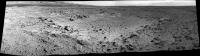
Sol 453 navcam pan:
We're moving again!  (Mods: I suppose it's time to start a new thread?) |
|
 |
 
|
|
|
Nov 14 2013, 09:32 PM
Post
#2
|
||
|
Solar System Cartographer Group: Members Posts: 10256 Joined: 5-April 05 From: Canada Member No.: 227 |
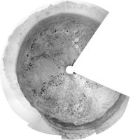
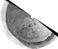
Off we go - this is a circular version of the 3/4 pan we have right now.
Phil
-------------------- ... because the Solar System ain't gonna map itself.
Also to be found posting similar content on https://mastodon.social/@PhilStooke Maps for download (free PDF: https://upload.wikimedia.org/wikipedia/comm...Cartography.pdf NOTE: everything created by me which I post on UMSF is considered to be in the public domain (NOT CC, public domain) |
|
|
|
|
|
|
Nov 15 2013, 05:35 PM
Post
#3
|
||
|
Solar System Cartographer Group: Members Posts: 10256 Joined: 5-April 05 From: Canada Member No.: 227 |
Location after the sol 454 drive. We only have a few pics and I have not yet located this spot on the map. EDIT: Got it! - not where I expected.
Phil
-------------------- ... because the Solar System ain't gonna map itself.
Also to be found posting similar content on https://mastodon.social/@PhilStooke Maps for download (free PDF: https://upload.wikimedia.org/wikipedia/comm...Cartography.pdf NOTE: everything created by me which I post on UMSF is considered to be in the public domain (NOT CC, public domain) |
|
|
|
|
|
|
Nov 15 2013, 07:16 PM
Post
#4
|
|
 Member Group: Members Posts: 821 Joined: 3-June 04 From: Brittany, France Member No.: 79 |
Panorama acquired with MastCam 34 on sol 453:
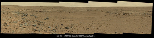
-------------------- |
|
|
|
|
Nov 16 2013, 02:21 PM
Post
#5
|
||
|
Senior Member Group: Members Posts: 2887 Joined: 22-April 05 From: Ridderkerk, Netherlands Member No.: 353 |
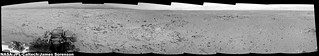
The Navcam NL B panoramic view on Sol 454.
Jan van Driel
|
|
|
|
|
|
|
Nov 16 2013, 07:46 PM
Post
#6
|
||
|
Solar System Cartographer Group: Members Posts: 10256 Joined: 5-April 05 From: Canada Member No.: 227 |
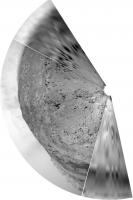
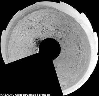
Here is a circular version of the panorama jvandriel posted just above, much more complete than my earlier one. Quite a rugged area. I expected we would go southwest but we turned due west. I see some thick protruding veins or fracture fill 120 m ahead in the HiRISE images (unless they are drifts, that could very well be... is it too late to retract my suggestion?), but it's perhaps more likely that the route will just turn SW past the big crater south of us. Another drive today - we'll see where that goes.
Phil
-------------------- ... because the Solar System ain't gonna map itself.
Also to be found posting similar content on https://mastodon.social/@PhilStooke Maps for download (free PDF: https://upload.wikimedia.org/wikipedia/comm...Cartography.pdf NOTE: everything created by me which I post on UMSF is considered to be in the public domain (NOT CC, public domain) |
|
|
|
|
|
|
Nov 16 2013, 11:08 PM
Post
#7
|
|
 Senior Member Group: Members Posts: 2432 Joined: 30-January 13 From: Penang, Malaysia. Member No.: 6853 |
QUOTE (Phil Stooke @ Nov 17 2013, 03:46 AM)  but it's perhaps more likely that the route will just turn SW past the big crater south of us. Another drive today - we'll see where that goes. Phil EDIT : Probably all AutoNav due to the duration of the drive (~195 minutes). |
|
|
|
|
Nov 17 2013, 04:29 AM
Post
#8
|
|
 Member Group: Members Posts: 691 Joined: 21-December 07 From: Clatskanie, Oregon Member No.: 3988 |
My version from Sol-454.
  |
|
|
|
|
Nov 17 2013, 08:36 PM
Post
#9
|
|
|
Senior Member Group: Members Posts: 2346 Joined: 7-December 12 Member No.: 6780 |
Sol 455 drive, seen from FLB, fisheye-corrected 125°, magnified twice:
 (4MB), and post-drive MAHLI: (4MB), and post-drive MAHLI: 
|
|
|
|
|
Nov 18 2013, 12:54 AM
Post
#10
|
|
|
Member Group: Members Posts: 691 Joined: 21-December 07 From: Clatskanie, Oregon Member No.: 3988 |
Cool Gerald!
 I made a couple of clips of my de-fisheye processing of a video that I am producing. http://www.youtube.com/watch?v=h2er8ESNrQE http://www.youtube.com/watch?v=4TFKmSNbSb8 |
|
|
|
|
Nov 18 2013, 01:49 AM
Post
#11
|
||
|
Senior Member Group: Members Posts: 1075 Joined: 21-September 07 From: Québec, Canada Member No.: 3908 |
Here's the sol 455 drive from the navcam perspective:
|
|
|
|
|
|
|
Nov 18 2013, 07:21 AM
Post
#12
|
|
|
Member Group: Members Posts: 691 Joined: 21-December 07 From: Clatskanie, Oregon Member No.: 3988 |
Not sure where to post this, But here is our entire Journey so far from Landing day all the way up to Sol-456
http://www.youtube.com/watch?v=VT480b8s5i8 |
|
|
|
|
Nov 18 2013, 10:06 AM
Post
#13
|
|
|
Senior Member Group: Members Posts: 2346 Joined: 7-December 12 Member No.: 6780 |
Great! Supercool!
|
|
|
|
|
Nov 18 2013, 10:27 AM
Post
#14
|
||
|
Senior Member Group: Members Posts: 2887 Joined: 22-April 05 From: Ridderkerk, Netherlands Member No.: 353 |
The Navcam NL B panoramic view on Sol 456.
Jan van Driel
|
|
|
|
|
|
|
Nov 18 2013, 02:27 PM
Post
#15
|
||
|
Solar System Cartographer Group: Members Posts: 10256 Joined: 5-April 05 From: Canada Member No.: 227 |
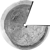
Circular version of the above. I got the impression from a recent article - but can't recall which one - that we might bypass Waypoint 3 and move straight to Waypoint 4 (which looks fascinating and very different from this area). Time will tell.
Phil
-------------------- ... because the Solar System ain't gonna map itself.
Also to be found posting similar content on https://mastodon.social/@PhilStooke Maps for download (free PDF: https://upload.wikimedia.org/wikipedia/comm...Cartography.pdf NOTE: everything created by me which I post on UMSF is considered to be in the public domain (NOT CC, public domain) |
|
|
|
|
|
|

|
Lo-Fi Version | Time is now: 31st October 2024 - 10:56 PM |
|
RULES AND GUIDELINES Please read the Forum Rules and Guidelines before posting. IMAGE COPYRIGHT |
OPINIONS AND MODERATION Opinions expressed on UnmannedSpaceflight.com are those of the individual posters and do not necessarily reflect the opinions of UnmannedSpaceflight.com or The Planetary Society. The all-volunteer UnmannedSpaceflight.com moderation team is wholly independent of The Planetary Society. The Planetary Society has no influence over decisions made by the UnmannedSpaceflight.com moderators. |
SUPPORT THE FORUM Unmannedspaceflight.com is funded by the Planetary Society. Please consider supporting our work and many other projects by donating to the Society or becoming a member. |
|