New mosaic map of Itokawa |

  |
New mosaic map of Itokawa |
 Sep 9 2010, 03:06 PM Sep 9 2010, 03:06 PM
Post
#1
|
||
|
Solar System Cartographer  Group: Members Posts: 10226 Joined: 5-April 05 From: Canada Member No.: 227 |
Having a bit of time free I have embarked on a new global photomosaic map of asteroid 25143 Itokawa. Follow its construction here as I go. I'm hoping it won't take more than 4 to 6 weeks as other duties call. The mosaic will eventually go into PDS.
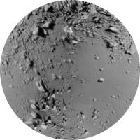
This follows the work I did on a map made from rendered images derived from Bob Gaskell's shape model. That had to be the first step because the control I'm using is derived from published lat-long grids superimposed on his rendered images. Now each individual image will be reprojected to fit that map. The large local relief will make it impossible to make all seams invisible, however. First step: the north polar area. The outer edge is at 40 N, with 90 N at the middle and 0 longitude at the top. Phil
-------------------- ... because the Solar System ain't gonna map itself.
Also to be found posting similar content on https://mastodon.social/@PhilStooke Maps for download (free PDF: https://upload.wikimedia.org/wikipedia/comm...Cartography.pdf NOTE: everything created by me which I post on UMSF is considered to be in the public domain (NOT CC, public domain) |
|
 |
 
|
|
|
Sep 9 2010, 04:29 PM
Post
#2
|
|
 Administrator Group: Admin Posts: 5172 Joined: 4-August 05 From: Pasadena, CA, USA, Earth Member No.: 454 |
Yaaaay Phil! I can't wait to see this come together. After I assembled Chuck Clark's cut-and-assemble model, I tried to identify the named features on it but made almost no headway at all; it was too hard to figure out what was being named on the photo map, even using the stuff from the USGS nomenclature page and map. I hope it'll be easier to figure things out with your maps. The large smooth area on this image is Sagamihara regio, right?
-------------------- My website - My Patreon - @elakdawalla on Twitter - Please support unmannedspaceflight.com by donating here.
|
|
|
|
|
Sep 9 2010, 05:21 PM
Post
#3
|
|
|
Solar System Cartographer Group: Members Posts: 10226 Joined: 5-April 05 From: Canada Member No.: 227 |
Yes, it's Sagamihara.
Phil -------------------- ... because the Solar System ain't gonna map itself.
Also to be found posting similar content on https://mastodon.social/@PhilStooke Maps for download (free PDF: https://upload.wikimedia.org/wikipedia/comm...Cartography.pdf NOTE: everything created by me which I post on UMSF is considered to be in the public domain (NOT CC, public domain) |
|
|
|
|
Sep 9 2010, 08:30 PM
Post
#4
|
||
|
Solar System Cartographer Group: Members Posts: 10226 Joined: 5-April 05 From: Canada Member No.: 227 |
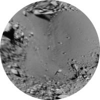
... and the south pole. Each of these polar maps is a mosaic of four images. There might be some improvements later. Getting the opposite sides to match well is not easy, but this is a start.
Phil
-------------------- ... because the Solar System ain't gonna map itself.
Also to be found posting similar content on https://mastodon.social/@PhilStooke Maps for download (free PDF: https://upload.wikimedia.org/wikipedia/comm...Cartography.pdf NOTE: everything created by me which I post on UMSF is considered to be in the public domain (NOT CC, public domain) |
|
|
|
|
|
|
Sep 9 2010, 08:44 PM
Post
#5
|
|
|
Administrator Group: Admin Posts: 5172 Joined: 4-August 05 From: Pasadena, CA, USA, Earth Member No.: 454 |
OK, so that one shows MUSES-C regio. There should also be a crater named Gando at -70, 205, but I see several vaguely circular outlines that might or might not be identified as crater rims, and I don't even know if they should look circular on this map...
-------------------- My website - My Patreon - @elakdawalla on Twitter - Please support unmannedspaceflight.com by donating here.
|
|
|
|
|
Sep 9 2010, 09:10 PM
Post
#6
|
||
|
Solar System Cartographer Group: Members Posts: 10226 Joined: 5-April 05 From: Canada Member No.: 227 |
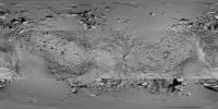
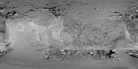
They should look circular on that map! But not on this one: here's the current version of the cylindrical global mosaic with the new poles added. I'll deal with trying to figure out nomenclature when it's all finished (if you can wait that long, Emily!)
Phil
-------------------- ... because the Solar System ain't gonna map itself.
Also to be found posting similar content on https://mastodon.social/@PhilStooke Maps for download (free PDF: https://upload.wikimedia.org/wikipedia/comm...Cartography.pdf NOTE: everything created by me which I post on UMSF is considered to be in the public domain (NOT CC, public domain) |
|
|
|
|
|
|
Sep 9 2010, 09:13 PM
Post
#7
|
|
|
Administrator Group: Admin Posts: 5172 Joined: 4-August 05 From: Pasadena, CA, USA, Earth Member No.: 454 |
Sorry, I'll be patient
 I've just had this danged Itokawa model sitting on my desk since I tried to assemble it, and when I couldn't use it to find all the named places, I got kinda frustrated. Carry on with your work, I'll wait till you're done! I've just had this danged Itokawa model sitting on my desk since I tried to assemble it, and when I couldn't use it to find all the named places, I got kinda frustrated. Carry on with your work, I'll wait till you're done!
-------------------- My website - My Patreon - @elakdawalla on Twitter - Please support unmannedspaceflight.com by donating here.
|
|
|
|
|
Sep 15 2010, 09:09 PM
Post
#8
|
||
|
Solar System Cartographer Group: Members Posts: 10226 Joined: 5-April 05 From: Canada Member No.: 227 |
Next step in the mosaic. I have added a section around the 90 degrees west longitude region, a mosaic of three images. The edges of it are a mess, but will be improved as the mapped area is extended. Edges are always a mess in this process.
Phil
-------------------- ... because the Solar System ain't gonna map itself.
Also to be found posting similar content on https://mastodon.social/@PhilStooke Maps for download (free PDF: https://upload.wikimedia.org/wikipedia/comm...Cartography.pdf NOTE: everything created by me which I post on UMSF is considered to be in the public domain (NOT CC, public domain) |
|
|
|
|
|
|
Sep 15 2010, 11:07 PM
Post
#9
|
|
 Senior Member Group: Moderator Posts: 2785 Joined: 10-November 06 From: Pasadena, CA Member No.: 1345 |
Thanks, Phil! It's really neat seeing the step-by-step evolution of mapping this asteroid!
-------------------- Some higher resolution images available at my photostream: http://www.flickr.com/photos/31678681@N07/
|
|
|
|
|
Sep 16 2010, 12:42 PM
Post
#10
|
|
|
Member Group: Members Posts: 140 Joined: 20-November 07 Member No.: 3967 |
QUOTE (elakdawalla @ Sep 9 2010, 12:29 PM)  After I assembled Chuck Clark's cut-and-assemble model, I tried to identify the named features on it but made almost no headway at all; it was too hard to figure out what was being named on the photo map, even using the stuff from the USGS nomenclature and map. Emily, is the lack of lat long lines on the pictures the root of your problem? I've got lat longs drawn on my plastic model, so -- as I'll be popping Phil's new mosaic onto the foldable map -- I should be able to locate all those features at the same time. Didn't know you've had trouble; speak up next time. Let me tell ya, drawing the lat longs onto the plastic model was a J O B! Things get verry complicated around the neck and chin. But now, it's fairly routine to locate a feature on the plastic model and then find it on a map, cylindrical or other-style. One question -- what happened to Woomera Regio? Did that become Arcoona Regio? Phil, if it's not too much trouble when you finish, please post (or send me directly) a larger-size file. Otherwise I'll again pixellate in those areas where your image greatly enlarges when it transforms to my constant scale natural boundary format -- the chin and neck particularly. |
|
|
|
|
Sep 16 2010, 03:35 PM
Post
#11
|
|
|
Solar System Cartographer Group: Members Posts: 10226 Joined: 5-April 05 From: Canada Member No.: 227 |
Will do!
Phil -------------------- ... because the Solar System ain't gonna map itself.
Also to be found posting similar content on https://mastodon.social/@PhilStooke Maps for download (free PDF: https://upload.wikimedia.org/wikipedia/comm...Cartography.pdf NOTE: everything created by me which I post on UMSF is considered to be in the public domain (NOT CC, public domain) |
|
|
|
|
Sep 16 2010, 05:05 PM
Post
#12
|
|
 Junior Member Group: Members Posts: 45 Joined: 11-March 05 From: Canada Member No.: 188 |
What would be the surface area of Itokawa? I'm just wondering how much real estate we're looking at here. Would it be the size of Wembley Stadium, or more like central London?
|
|
|
|
|
Sep 16 2010, 06:36 PM
Post
#13
|
|
|
Founder Group: Chairman Posts: 14434 Joined: 8-February 04 Member No.: 1 |
http://en.wikipedia.org/wiki/25143_Itokawa
Dimensions 535 × 294 × 209 m Very roughly - call it a 300m sphere, Surface area, very roughly, about a quarter of a million square metres |
|
|
|
|
Sep 17 2010, 12:02 AM
Post
#14
|
|
|
Junior Member Group: Members Posts: 36 Joined: 14-July 06 Member No.: 972 |
QUOTE (djellison @ Sep 16 2010, 06:36 PM) Very roughly - call it a 300m sphere, Surface area, very roughly, about a quarter of a million square metres So probably a bit over 3 Wembly's then. Assuming my back of the envelope calculation of the latter's area at nearly 80,000 m2 is correct (based on a reported circumference of 1 km). |
|
|
|
|
Sep 17 2010, 03:02 PM
Post
#15
|
|
|
Junior Member Group: Members Posts: 45 Joined: 11-March 05 From: Canada Member No.: 188 |
Thank you!
So you could probably stroll around it an hour or so (under Earth gravity!). Interesting. |
|
|
|
|

|
Lo-Fi Version | Time is now: 23rd September 2024 - 05:44 PM |
|
RULES AND GUIDELINES Please read the Forum Rules and Guidelines before posting. IMAGE COPYRIGHT |
OPINIONS AND MODERATION Opinions expressed on UnmannedSpaceflight.com are those of the individual posters and do not necessarily reflect the opinions of UnmannedSpaceflight.com or The Planetary Society. The all-volunteer UnmannedSpaceflight.com moderation team is wholly independent of The Planetary Society. The Planetary Society has no influence over decisions made by the UnmannedSpaceflight.com moderators. |
SUPPORT THE FORUM Unmannedspaceflight.com is funded by the Planetary Society. Please consider supporting our work and many other projects by donating to the Society or becoming a member. |
|