HRSC DEM Movies |

  |
HRSC DEM Movies |
 Jan 6 2008, 07:55 PM Jan 6 2008, 07:55 PM
Post
#1
|
||
|
Founder  Group: Chairman Posts: 14432 Joined: 8-February 04 Member No.: 1 |
Thought I'd start a new thread for stuff done with the HRSC DEM's....
http://www.rlproject.com/HRSC/2039/2039_0000_flydown_hi.mov (8.3 meg) http://www.rlproject.com/HRSC/2039/2039_0000_flydown_lo.mov (3.0 meg)
|
|
 |
 
|
|
|
Jan 6 2008, 07:57 PM
Post
#2
|
|
|
Founder Group: Chairman Posts: 14432 Joined: 8-February 04 Member No.: 1 |
|
|
|
|
|
Jan 6 2008, 07:58 PM
Post
#3
|
||
|
Founder Group: Chairman Posts: 14432 Joined: 8-February 04 Member No.: 1 |
http://www.rlproject.com/HRSC/446_438/446_438_flydown_hi.mov (10.7 meg)
http://www.rlproject.com/HRSC/446_438/446_438_flydown_lo.mov (3.8 meg) I'll confess, this one went a bit wrong, and a long swathe of the animation ended up being 'underwater' as it were. So it cut short 
|
|
|
|
|
|
|
Jan 6 2008, 08:05 PM
Post
#4
|
|
 Senior Member Group: Admin Posts: 4763 Joined: 15-March 05 From: Glendale, AZ Member No.: 197 |
I'm just speechless. Thanks for these Doug.
I love doing this with Google Earth. Hopefully we'll have enough data some day for the entire Red Planet. -------------------- If Occam had heard my theory, things would be very different now.
|
|
|
|
|
Jan 6 2008, 11:10 PM
Post
#5
|
||
|
Founder Group: Chairman Posts: 14432 Joined: 8-February 04 Member No.: 1 |
Some DEM's are cool, some not so great. Cloud, ice, fog all screw them up (nothing to co-register for elevation I guess)
http://www.rlproject.com/HRSC/1343/1343_rotate_hi.mov (6.7 meg) http://www.rlproject.com/HRSC/1343/1343_rotate_lo.mov (2.3 meg)
|
|
|
|
|
|
|
Jan 6 2008, 11:46 PM
Post
#6
|
||
|
Founder Group: Chairman Posts: 14432 Joined: 8-February 04 Member No.: 1 |
http://www.rlproject.com/HRSC/515/515_hi.mov (33.2 meg)
http://www.rlproject.com/HRSC/515/515_lo.mov (10.3 meg) (both still uploading should be there by midnight - 10 mins from now. Bed time for me
|
|
|
|
|
|
|
Jan 6 2008, 11:57 PM
Post
#7
|
|
|
Founder Group: Chairman Posts: 14432 Joined: 8-February 04 Member No.: 1 |
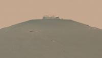
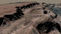
This one (attached - Arsinoes Chaos ) and a very long-noodle of Olympus Mons rendering now.
These things usually have an ND image of 12.5-50m/pixel, 4 colour images of 100-250m/pixel and an elevation image, usually of about the same res as the colour, perhaps slightly lower. Most of the time I drape the colour over the ND to super-res it. With the Ol. Mons one, I thought "Do I drop the colour over the higher res ND filter?" Then I discovered the ND is 17568x144800 - That's a full HiRISE image sort of filesize, and the HRSC to Tif convertor has to load the whole image into ram. So that's a no for now On the upside, I should be on 8 gig of ram by the end of the week (dropping 4 more in)I want to do Elysium Mons, but the DTM is so soft it's a bit dull really. Doug |
|
|
|
|
Jan 7 2008, 03:08 AM
Post
#8
|
|
|
Senior Member Group: Members Posts: 1074 Joined: 21-September 07 From: Québec, Canada Member No.: 3908 |
Fantastic animations!
How much vertical exaggeration do you have? As much as 5 to 1, I would guess. Could you try one without vertical exaggeration? |
|
|
|
|
Jan 7 2008, 07:41 AM
Post
#9
|
|
|
Founder Group: Chairman Posts: 14432 Joined: 8-February 04 Member No.: 1 |
As I've said elsewhere, the vert exag is not an exact science yet - but it's far more like 2:1 than 5:1.
Doug |
|
|
|
|
Jan 7 2008, 10:33 PM
Post
#10
|
||
|
Founder Group: Chairman Posts: 14432 Joined: 8-February 04 Member No.: 1 |
http://www.rlproject.com/HRSC/500/500_around_hi.mov (17.2 meg)
http://www.rlproject.com/HRSC/500/500_around_lo.mov (7.1 meg)
Trying now to do one of Holden and Eberswalde, with a CTX swathe across the Eberswalde part. Cropped myself down to a tiny tiny part of the orig HRSC image, but having to blow it up 5x to match the res of the CTX (i.e. show CTX at full res) is bringing my machine to its knees! Shh - don't tell it, I've got the RGB to drop on top next Doug |
|
|
|
|
|
|
Jan 8 2008, 01:14 AM
Post
#11
|
|
 IMG to PNG GOD Group: Moderator Posts: 2251 Joined: 19-February 04 From: Near fire and ice Member No.: 38 |
Even though I haven't downloaded all of these yet I can say that these are awesome. I'm surprised I haven't seen more HRSC animations - this should be great for PR purposes.
If only we had some HIRISE DEMs... |
|
|
|
|
Jan 8 2008, 03:30 PM
Post
#12
|
|
|
Senior Member Group: Members Posts: 3516 Joined: 4-November 05 From: North Wales Member No.: 542 |
Just wanted to say how very much I appreciate these animations.
I probably missed some earlier discussion but I was wondering, Doug, if vertical scale is a parameter that you can 'tweak' relatively easily, if (say) you wanted to make versions with no exaggeration?
|
|
|
|
|
Jan 8 2008, 05:53 PM
Post
#13
|
|
|
Founder Group: Chairman Posts: 14432 Joined: 8-February 04 Member No.: 1 |
I can change it very easily - and actually getting it right on 1x elev isn't too problematic either. I've not measured most of these accurately, but they're averaging 1.5ish - 2ish, that sort of thing.
Doug |
|
|
|
|
Jan 8 2008, 06:24 PM
Post
#14
|
|
 Chief Assistant Group: Admin Posts: 1409 Joined: 5-January 05 From: Ierapetra, Greece Member No.: 136 |
 ! I was looking forward to something like this from you Doug, this stuff is very pleasing. ! I was looking forward to something like this from you Doug, this stuff is very pleasing.Is that 3dsMax-generated? Nico -------------------- photographer, space imagery enthusiast, proud father and partner, and geek.
http://500px.com/sacred-photons & |
|
|
|
|
Jan 8 2008, 06:32 PM
Post
#15
|
|
|
Founder Group: Chairman Posts: 14432 Joined: 8-February 04 Member No.: 1 |
Yup - 3ds max, using the VRay renderer for displacement of the terrain.
Oly.Mons to be added later. It's a big noodle much like the very first one, but it's cool Doug |
|
|
|
|
Jan 8 2008, 06:55 PM
Post
#16
|
|
|
Chief Assistant Group: Admin Posts: 1409 Joined: 5-January 05 From: Ierapetra, Greece Member No.: 136 |
Ah, THE mountain... I'm eager to see what's coming. Glad to know you won't be bothered with ram issues.
Nico -------------------- photographer, space imagery enthusiast, proud father and partner, and geek.
http://500px.com/sacred-photons & |
|
|
|
|
Jan 8 2008, 08:23 PM
Post
#17
|
|
|
Senior Member Group: Members Posts: 3516 Joined: 4-November 05 From: North Wales Member No.: 542 |
QUOTE (djellison @ Jan 8 2008, 05:53 PM)  actually getting it right on 1x elev isn't too problematic either. That's good. I'd like to see at least some at 1x. Getting a feel for the true gradients is important if one wants to set ones mind to wondering about slope stability, fluidity of lava flows and the like. (I've never managed to make any sense of Venus because of having my head filled with grossly vertically stretched Magellan imagery right from the start.) Anyhow - wonderful stuff. Keep it coming! |
|
|
|
|
Jan 8 2008, 09:59 PM
Post
#18
|
|
|
Founder Group: Chairman Posts: 14432 Joined: 8-February 04 Member No.: 1 |
http://hrscview.fu-berlin.de/cgi-bin/ion-p?page=entry.ion will always let you look at them in 1x perspective. The problem is, 99% of them are dull as dishwater when you do that
Doug |
|
|
|
|
Jan 8 2008, 10:19 PM
Post
#19
|
|
|
Founder Group: Chairman Posts: 14432 Joined: 8-February 04 Member No.: 1 |
|
|
|
|
|
Jan 8 2008, 10:23 PM
Post
#20
|
|
|
Founder Group: Chairman Posts: 14432 Joined: 8-February 04 Member No.: 1 |
Tonight - Eberswalde Crater with a CTX swathe on top, and maybe Nilli Fossae, probably without a CTX swathe on top.
They'll render tomorrow - and we're off playing Guitar Hero 3 tomorrow night, so they'll have to wait till Thursday Doug |
|
|
|
|
Jan 9 2008, 12:31 AM
Post
#21
|
||
|
Founder Group: Chairman Posts: 14432 Joined: 8-February 04 Member No.: 1 |
The texture for Eberswalde took for ever.
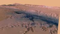
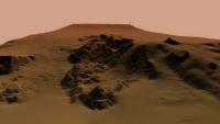
Just for you Nige - comparing 1x and 3x elevation at Nili Fossae (one of the MSL landing site proposals). Sat down, did the maths, made sure it was the right total altitude and that the difference between max and min altitiude matched the file headers. I've actually set both of these rendering in full. The problem is getting the cameras to match exactly. (you can stretch a terrain vertically quite easily, but not the path that a camera takes) so not the exact same view, but it's the same frame number from two very similar animations. You can probably guess which is the most accurate I can make to the actual, and which is 3x exag of that For reference, this entire swath is 119.7km wide, 1059 km long - has a max altitude of -857m and a min altitude of -6866m (which I turn into adjusted altitiude based on the hrsc2tif idl module adding a value to make them all positive) - So a terrain altitude 'range' of 6 km from highest to lowest on the whole swath. i.e. 0.6% of the length - hence why they can be a bit dull. Those swath dimensions refer to this entire box in which the map projected image sits - http://pds-geosciences.wustl.edu/mex/mex-m...88_0000_gr3.jpg - I create an alpha channel for the terrain to remove the crap off the edges, as the displacement process goes nuts with the edge of the elevation map ( hence all the little funky jagged hedges around the edge of most of these ) Doug
Attached thumbnail(s)
|
|
|
|
|
|
|
Jan 9 2008, 12:51 AM
Post
#22
|
|
|
Senior Member Group: Admin Posts: 4763 Joined: 15-March 05 From: Glendale, AZ Member No.: 197 |
I think for maximum esthetic value you need something between 1.5 and 2.5. 1 is certainly too flat and 3 is rather tortured.
-------------------- If Occam had heard my theory, things would be very different now.
|
|
|
|
|
Jan 9 2008, 01:05 AM
Post
#23
|
||
|
Founder Group: Chairman Posts: 14432 Joined: 8-February 04 Member No.: 1 |
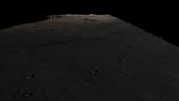
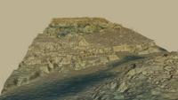
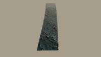
This is the first frame + a middle-ish frame of the Eberswalde anim - the landing site, very roughly, markes with a white circle (which vanished after 2 secs) - you can see the CTX swath in there. Sadly - I couldn't get 3ds to handle the 23k x 32k tif I wanted to use - so it's at 50% of that.
This + 2 x Nili for Friday probably.
Attached thumbnail(s)
|
|
|
|
|
|
|
Jan 9 2008, 10:04 AM
Post
#24
|
|
|
Senior Member Group: Members Posts: 3516 Joined: 4-November 05 From: North Wales Member No.: 542 |
Thanks Doug. So, EGD, Mars is too flat for ya?

|
|
|
|
|
Jan 9 2008, 04:20 PM
Post
#25
|
|
|
Senior Member Group: Members Posts: 1074 Joined: 21-September 07 From: Québec, Canada Member No.: 3908 |
QUOTE (ElkGroveDan @ Jan 8 2008, 07:51 PM) I think for maximum esthetic value you need something between 1.5 and 2.5. 1 is certainly too flat and 3 is rather tortured. For my part, I would rather see Mars as it really is, without vertical exaggeration. |
|
|
|
|
Jan 9 2008, 05:17 PM
Post
#26
|
|
|
Founder Group: Chairman Posts: 14432 Joined: 8-February 04 Member No.: 1 |
And the HRSCView website will let you do that, to all the dem's they've got
Doug |
|
|
|
|
Jan 9 2008, 05:18 PM
Post
#27
|
|
 Member Group: Members Posts: 568 Joined: 20-April 05 From: Silesia Member No.: 299 |
I'm sorry that I don't share your delight. Not to shabby, but it's only animation, notting more. I prefer to watch real MRO's data (many times better) using IAS Viewer's functions "Create Waypoints" and "Waypoint following". For example, I suggest planning journey from west to east over Cerberus Fossae (PSP_003650_1900) with magnification 1:2. It's better and real movie.
-------------------- Free software for planetary science (including Cassini Image Viewer).
http://members.tripod.com/petermasek/marinerall.html |
|
|
|
|
Jan 9 2008, 05:52 PM
Post
#28
|
|
|
Founder Group: Chairman Posts: 14432 Joined: 8-February 04 Member No.: 1 |
QUOTE (peter59 @ Jan 9 2008, 05:18 PM) real MRO's data (many times better) There's nothing 'fake' about this data. I've not made any part of it up - it all comes straight from the actuall data provided by the HRSC team. HiRISE imagery is many times higher resolution ( 100 - 200 x better resolution ) - but based on that argument, perhaps we shoudl take Themis, HRSC, CTX and MARCI and turn them all off. Only HiRISE provides that resolution, so everything else must be useless, right  I don't think anyone is claiming this is the 'best' data, nor the 'best' way to look at it - but it's something new being done with a fascinating and growing data set. Scrolling around HiRISE imagery with the viewer is another way to look at a different dataset that shows us different things from a different spacial perspective. What's unique about HiRISE is that the imagery is immediately made sense of by even an uninformed human brain as it is of a resolution that we can interpret in real terms. What's unique about HRSC is that it matches moderate resolution and higher resolution elevation data. Now - DEM's with HiRISE imagery (which will hopefully make it 'out' at some point) would be the best of both worlds - astonishing resolution in every dimension ( except time ). But even that isn't the 'best' or 'most real' way to look at Mars. Doug |
|
|
|
|
Jan 9 2008, 06:14 PM
Post
#29
|
|
|
Member Group: Admin Posts: 468 Joined: 11-February 04 From: USA Member No.: 21 |
QUOTE (djellison @ Jan 9 2008, 09:52 AM) ...but it's something new being done with a fascinating and growing data set. Cheers to that! By adding topographic information, the already impressive, voluminous (and overwhelming) data returned by HRSC becomes that much more valuable both in scientific and outreach potential. I'm excited that the addition of the DTEMs has inspired you to dig in and share the best of what is available. Keep it up
|
|
|
|
|
Jan 10 2008, 10:03 AM
Post
#30
|
|
 Member Group: Members Posts: 524 Joined: 24-November 04 From: Heraklion, GR. Member No.: 112 |
Not everybody has the time to scroll through HiRISE imagery with the viewer, so Doug's work is highly appreciated here...
Thanks Doug, and keep it up ! |
|
|
|
|
Jan 10 2008, 02:18 PM
Post
#31
|
|
 The Poet Dude Group: Moderator Posts: 5551 Joined: 15-March 04 From: Kendal, Cumbria, UK Member No.: 60 |
QUOTE (TheChemist @ Jan 10 2008, 10:03 AM) Not everybody has the time to scroll through HiRISE imagery with the viewer, so Doug's work is highly appreciated here... Thanks Doug, and keep it up ! ... and not everyone has the equipment or internet service required to use the viewer and see the images at full resolution either, so Doug's work is ESPECIALLY appreciated by those of us with computers less intelligent than HAL. Thank you Doug!
-------------------- |
|
|
|
|
Jan 10 2008, 09:54 PM
Post
#32
|
|
|
Founder Group: Chairman Posts: 14432 Joined: 8-February 04 Member No.: 1 |
|
|
|
|
|
Jan 10 2008, 09:57 PM
Post
#33
|
|
|
Founder Group: Chairman Posts: 14432 Joined: 8-February 04 Member No.: 1 |
|
|
|
|
|
Jan 11 2008, 12:34 PM
Post
#34
|
|
|
Senior Member Group: Members Posts: 3516 Joined: 4-November 05 From: North Wales Member No.: 542 |
Superb, Doug. Gives a really good feel for the place.
|
|
|
|
|
Jan 12 2008, 04:07 PM
Post
#35
|
||
|
Founder Group: Chairman Posts: 14432 Joined: 8-February 04 Member No.: 1 |
http://www.rlproject.com/HRSC/360_334/360_334_higher_hi.mov (21.8 meg)
http://www.rlproject.com/HRSC/360_334/360_334_higher_lo.mov (7.7 meg)
The next one is the same terrain - particularly happy with this one - but a different fly around. . |
|
|
|
|
|
|
Jan 12 2008, 04:11 PM
Post
#36
|
|
|
Founder Group: Chairman Posts: 14432 Joined: 8-February 04 Member No.: 1 |
|
|
|
|
|
Jan 25 2008, 11:04 PM
Post
#37
|
||
|
Founder Group: Chairman Posts: 14432 Joined: 8-February 04 Member No.: 1 |
I've done the full 511 swath. 720p, motion blur, atmospheric haze, the works
http://www.rlproject.com/HRSC/511_full/511_full_hi.mov (41 meg) http://www.rlproject.com/HRSC/511_full/511_full_lo.mov (16 meg)
|
|
|
|
|
|
|
Feb 5 2008, 05:25 PM
Post
#38
|
|
 Administrator Group: Admin Posts: 5172 Joined: 4-August 05 From: Pasadena, CA, USA, Earth Member No.: 454 |
-------------------- My website - My Patreon - @elakdawalla on Twitter - Please support unmannedspaceflight.com by donating here.
|
|
|
|
|
Feb 5 2008, 05:47 PM
Post
#39
|
|
|
Founder Group: Chairman Posts: 14432 Joined: 8-February 04 Member No.: 1 |
That's a great big mosaic of DTM's - most of which have not been released yet - but yes, it's the ingredients to those that I've been using
http://hrscview.fu-berlin.de/mex4/ Doug |
|
|
|
|
Feb 6 2008, 10:34 AM
Post
#40
|
|
|
Newbie Group: Members Posts: 12 Joined: 6-February 08 Member No.: 4042 |
Doug,
I've been following this thread for a while now. Since you posted at Celestia's forum. I'm impressed with all your clips. I noticed that the ESA is about to release more DTM's. Can't wait. I did an experimental model with file h0344. I created a short video while running Celestia and posted it on you tube. http://www.youtube.com/watch?v=zmrJYZxJmtY I do have a clip with better resolution at my web site page. For those running Windows this clip probably requires the xvid codec. There is a link for it on my web page. I did a couple of others on you tube that uses the DTM h0344 from HRSC and uses a MRO CTX image as the texture. http://www.youtube.com/watch?v=kz5Lte6p_NE http://www.youtube.com/watch?v=dssQhME4Ksc cartrite |
|
|
|
|
Mar 28 2008, 11:47 AM
Post
#41
|
|
|
Senior Member Group: Members Posts: 3516 Joined: 4-November 05 From: North Wales Member No.: 542 |
Doug, I've just seen your 'White Rock' animation posted by Emily - very nice.
|
|
|
|
|
Mar 28 2008, 01:39 PM
Post
#42
|
|
|
Founder Group: Chairman Posts: 14432 Joined: 8-February 04 Member No.: 1 |
I'm annoyed that the DEM's that are available to download via the HRSCView site are clearly not as high fidelity as those used by the HRSC team to produce their illustrations. I'm not sure how or why, but they're just not of the same quality. But - given what's available, I don't think I could manage much better than that apart, perhaps, from using the MOLA set to give some context. I've been doing some renderings of mars as a sphere with the MOLA set and it's just breathtaking, even at the 1/4 of it's full res that I've been using.
Doug |
|
|
|
|
Apr 6 2017, 12:55 PM
Post
#43
|
|
|
Member Group: Members Posts: 923 Joined: 10-November 15 Member No.: 7837 |
Is it legal to resurrect a thread after 9 years?
Ladon Valles West Click thru for a 1080 video...  I wonder what Doug is up to?  -------------------- |
|
|
|
|
Apr 6 2017, 03:46 PM
Post
#44
|
|
|
Founder Group: Chairman Posts: 14432 Joined: 8-February 04 Member No.: 1 |
This and that :-)
|
|
|
|
|
Apr 27 2017, 05:15 PM
Post
#45
|
|
|
Member Group: Members Posts: 923 Joined: 10-November 15 Member No.: 7837 |
Tinto Vallis
Click thru for a video...  Blended 2 orbit strips. *update* Here is a simple pan along the texture used in the previous clip. Click thru for a video...  And some stills...     *update2* Palos Crater...  -------------------- |
|
|
|
|
Jun 19 2017, 12:28 PM
Post
#46
|
|
|
Member Group: Members Posts: 923 Joined: 10-November 15 Member No.: 7837 |
Holden Crater
Video...  Portrait... 
-------------------- |
|
|
|
|
Oct 19 2017, 04:00 PM
Post
#47
|
|
|
Member Group: Members Posts: 923 Joined: 10-November 15 Member No.: 7837 |
-------------------- |
|
|
|
|

|
Lo-Fi Version | Time is now: 31st May 2024 - 10:39 AM |
|
RULES AND GUIDELINES Please read the Forum Rules and Guidelines before posting. IMAGE COPYRIGHT |
OPINIONS AND MODERATION Opinions expressed on UnmannedSpaceflight.com are those of the individual posters and do not necessarily reflect the opinions of UnmannedSpaceflight.com or The Planetary Society. The all-volunteer UnmannedSpaceflight.com moderation team is wholly independent of The Planetary Society. The Planetary Society has no influence over decisions made by the UnmannedSpaceflight.com moderators. |
SUPPORT THE FORUM Unmannedspaceflight.com is funded by the Planetary Society. Please consider supporting our work and many other projects by donating to the Society or becoming a member. |
|