Welcome Professor "brine splat" Burt, "a chance to ask questions... or raise objections" |

  |
Welcome Professor "brine splat" Burt, "a chance to ask questions... or raise objections" |
 Jun 15 2007, 08:37 PM Jun 15 2007, 08:37 PM
Post
#1
|
|
 Senior Member  Group: Members Posts: 2173 Joined: 28-December 04 From: Florida, USA Member No.: 132 |
QUOTE (dburt @ Jun 14 2007, 11:04 PM)  As an aside, the related suggestion that at least some of the fine-grained layers above or below any boulder deposits (or elsewhere on Mars) could likewise represent ancient impact deposits (non-ballistic fine-grained sand and dust distributed over vast areas by fast-moving, turbulent, erosive gaseous density currents - a.k.a. impact surge clouds - or by the winds as later fallout) already seems to have aroused considerable controversy on this forum, but again that's peripheral to Emily's boulder comment. So you're the dburt of Basal Surge fame? "ASU geologists L. Paul Knauth and Donald Burt, who along with Kenneth Wohletz of Los Alamos National Laboratory, say that base surges resulting from massive explosions caused by meteorite strikes offer a simpler and more consistent explanation for the rock formations and sediment layers found at the Opportunity site." http://www.asu.edu/news/stories/200512/200..._meteorites.htm I haven't followed the situation closely enough to ask any good questions, but I wonder if anyone else here would like to ask about your current views. for reference, the basal surge thread is here: http://www.unmannedspaceflight.com/index.p...surge&st=30 |
 |
 
|
|
Jun 16 2007, 02:11 AM
Post
#2
|
|
|
Member Group: Members Posts: 384 Joined: 4-January 07 Member No.: 1555 |
Yes, guilty as charged - that "brine splat" Burt. As someone who, like many of you, is addicted to looking at the downloaded MER images almost daily (vicarious field work on another planet), I've long admired the inspired image processing that many on this site carry out, and was overcome with admiration a few days ago when I observed how rapidly everyone zoomed in on problems inherent in news stories about puddles on the face of "Burns Cliff". So I thought I should finally stop lurking and log in to give anyone who wishes a chance to ask questions about or raise objections to our published ideas on Mars impacts, and their hypothetical relation to observations at the two rover sites. (And yes, I'm well aware that some here have enthusiastically and at length found fault with these ideas already, in the thread that was cited and quite a few others. As a life-long professor, it's my job to be grateful for and encourage such enthusiasm, even if I'm secretly grinding my teeth.)
BTW, I'm pretty sure that this particular thread is not the best place for such a discussion. So if anyone has a general question or comment please feel free start a new thread, perhaps in the "Mars general" area (if only to liven things up a bit while we're all waiting for Oppy to enter Victoria). --Don |
|
|
|
|
Jun 16 2007, 06:51 AM
Post
#3
|
|
|
Merciless Robot Group: Admin Posts: 8784 Joined: 8-December 05 From: Los Angeles Member No.: 602 |
Professor Burt, let me say merely that I am glad you are here--it's a good place, in all senses of the word! --and that, as a layperson, I greatly admire your intellectual honesty.
Cannot speak for admin policies of course re topic placement, but it seems quite safe to say that your opinions and contributions will be welcomed by all and may often encourage provocative, often quite enlightening comments...that is the hallmark of UMSF.com. (Not running the circus, here--that's poor Doug's job--I'm just one of the clowns! Welcome, welcome, sir!  ) )
-------------------- A few will take this knowledge and use this power of a dream realized as a force for change, an impetus for further discovery to make less ancient dreams real.
|
|
|
|
|
Jun 16 2007, 03:08 PM
Post
#4
|
|
|
Senior Member Group: Members Posts: 2173 Joined: 28-December 04 From: Florida, USA Member No.: 132 |
QUOTE (nprev @ Jun 16 2007, 02:51 AM) Professor Burt, let me say merely that I am glad you are here-- Thanks, nprev, for putting out the welcome mat. [EDIT -EGD] |
|
|
|
|
Jun 16 2007, 05:58 PM
Post
#5
|
|
|
Senior Member Group: Members Posts: 2998 Joined: 30-October 04 Member No.: 105 |
Welcome to Mars, Prof Burt. Here are a couple of my favorite 'local' discussions on basal surge/brine splat:
http://www.unmannedspaceflight.com/index.php?showtopic=1584 http://www.unmannedspaceflight.com/index.php?showtopic=2438 http://www.unmannedspaceflight.com/index.php?showtopic=1884 http://www.unmannedspaceflight.com/index.php?showtopic=3060 --Bill -------------------- |
|
|
|
|
Jun 17 2007, 08:12 AM
Post
#6
|
|
|
Member Group: Members Posts: 384 Joined: 4-January 07 Member No.: 1555 |
Thanks much for the warm welcome. Am I now supposed to feel like an innocent sheep being fattened for slaughter? (Are those knives I hear being sharpened in the kitchen?)
 In any case, thanks also for the brief compendium of relevant threads, some of which were old enough that I hadn't read them previously. In addition, here's a more recent thread in which a few correspondents dumped on my "mine dump" article from Eos last December: In any case, thanks also for the brief compendium of relevant threads, some of which were old enough that I hadn't read them previously. In addition, here's a more recent thread in which a few correspondents dumped on my "mine dump" article from Eos last December:http://www.unmannedspaceflight.com/index.php?showtopic=3643 Rather than trying to respond at length to all of the comments in these threads, I'd much prefer to make brief replies to specific points or queries. Otherwise, I may start pontificating at random, like I sometimes do in class, and that could get really boring. Here's a warning sample: Along with many of you, I'm a firm believer in Carl Sagan's famous dictum applied to Mars, that "Extraordinary claims require extraordinary proof." So far we haven't seen that proof for most aspects of Meridiani or Gusev geology. As an example, it would be premature for me to call those enigmatic spherules "impact spherules" (not the same as tektites, BTW, because tektites are not vapor condensates like spherules, but rather are oddly shaped splash droplets) or "accretionary lapilli" or even "hematite hailstones". Of course, it is just as premature for far too many writers to baldly refer to them as "concretions" (some amateurs regard them as biological products, yet another hypothesis). "Spherules" just describes their obvious spherical shape, and "blueberries" and "BB's" describe their uniformly tiny size, without genetic connotations. For this example alone, we have at least three competing hypotheses, but so far none of them has advanced to being a theory (recall that evolution is a theory, as is plate tectonics, and even gravity). In this regard, any valid scientific hypothesis is testable, usually via making various predictions; it can become a theory only after the competing hypotheses fail their tests. Until now I haven't seen any testable predictions made as part of the MER team's remarkably complex and elegant Meridiani hypotheses, so perhaps they feel these predictions should be obvious. Nevertheless, I'd prefer to see them spelled out explicitly. Here's another: I'm also a firm believer in Occam's razor, which (as reportedly reworded by Einstein) states that the best hypothesis is the simplest one that accounts for all the observations. Although none of us are experts on impacts (Wohletz probably comes closest, through his experience with bomb tests and exploding volcanoes), my co-authors and I settled on the impact hypothesis via the process of elimination - it seemed the simplest one that could account for all of the rover and orbital observations, and it was obviously testable. The hypothesis in one word: Boom! (Is that simple enough?) More complex: Boom, boom, boom, boom... (= multiple impacts). Well - now you've been warned about Herr Doktor Professor. Please stop me before I stick out my gut and begin to pontificate again... --Don |
|
|
|
|
Jun 17 2007, 08:45 AM
Post
#7
|
|
|
Founder Group: Chairman Posts: 14432 Joined: 8-February 04 Member No.: 1 |
Trying to play devils advocate here - how does that tie in with the fact that heading south (up section) the spherules got smaller and smaller and almost dissappeared - and then reappeared in huge quantities on the Victoria annulus?
And to be fair - the MER team have not gone "here are concretions - bingo - water" - there are more slices to the evidence pie than that ( Jarosite, Vugs, Sulphates predicted by Burns, Small scale cross bedding) If you go to a place with an extensive prediction ready to test - then surely you're going to be prone to a biased interpretation of what happened? Alternatively - what obvious tests do you have in mind? Doug (Not a geologist, just playing devils advocate )
|
|
|
|
|
Jun 17 2007, 11:25 AM
Post
#8
|
|
|
Senior Member Group: Members Posts: 2998 Joined: 30-October 04 Member No.: 105 |
No one really dumpes on the mine dump hypothesis; in my experience, anytime you find sulfates you need to look for sulfides.
Thedownside to the brine spalt/base surge hypotheis is that it tends to get rolled out as a universal, all-encompassing explanation for Meridiani, whereas there are clearly many interactive processes going on there. --Bill -------------------- |
|
|
|
|
Jun 17 2007, 01:49 PM
Post
#9
|
|
|
Merciless Robot Group: Admin Posts: 8784 Joined: 8-December 05 From: Los Angeles Member No.: 602 |
My working hypothesis re blueberry size has been duration of immersion: the longer they were in solution, the bigger they got. What would be interesting to know is the rate at which these things grew (assuming of course here that they are in fact concretions).
As a kid, I saw copper sulfate accretions (asymmetrical) develop in wet spots on mine tailings in Butte, MT over the course of a year or two, some becoming quite large--2-3 cm across on their longest dimensions. I don't know if iron-based minerals can do this as quickly, but if so then this may argue that Merdiani's blueberries might not have required long-term immersion to form. -------------------- A few will take this knowledge and use this power of a dream realized as a force for change, an impetus for further discovery to make less ancient dreams real.
|
|
|
|
|
Jun 17 2007, 03:28 PM
Post
#10
|
|
 Senior Member Group: Members Posts: 3419 Joined: 9-February 04 From: Minneapolis, MN, USA Member No.: 15 |
QUOTE (dburt @ Jun 17 2007, 03:12 AM) ...recall that evolution is a theory, as is plate tectonics, and even gravity. I respectfully disagree with this statement. The processes are proven. Some of the mechanisms by which these processes function are not proven, and are therefore theoretical. (I have the same argument with my girlfriend... )QUOTE (dburt @ Jun 17 2007, 03:12 AM) ...recall that evolution is a theory, as is ...my co-authors and I settled on the impact hypothesis via the process of elimination - it seemed the simplest one that could account for all of the rover and orbital observations, and it was obviously testable. The hypothesis in one word: Boom! (Is that simple enough?) More complex: Boom, boom, boom, boom... (= multiple impacts). Now, here is where you get closer to some of the mechanisms than many others, I think. While I truly believe that the Merdiani landforms and minerology were formed by groundwater and standing water (among other things), we have to be aware that impacts have modified the Martian surface far more than they have modified Earth. Impact is a primary agent in much planetary surface formation, and I agree that when you invoke Occam's Razor, the first thing you need to look at are impact processes. QUOTE (dburt @ Jun 17 2007, 03:12 AM) ...recall that evolution is a theory, as is Well - now you've been warned about Herr Doktor Professor. Please stop me before I stick out my gut and begin to pontificate again... Hey -- as long as you don't mind our honest responses (and you don't start wearing tin-foil hats), we *love* pontification around here! Please, keep it up. Or, paraphrasing what someone once said, I may not agree with all of your hypotheses, but I defend to the death your right to express them... -the other Doug -------------------- The trouble ain't that there is too many fools, but that the lightning ain't distributed right. -Mark Twain
|
|
|
|
|
Jun 17 2007, 05:31 PM
Post
#11
|
|
|
Senior Member Group: Members Posts: 2173 Joined: 28-December 04 From: Florida, USA Member No.: 132 |
As an interested, but not knowledgeable, observer, I'm struck this way:
I've been shown the small scale evidence that djellison mentioned that indicates water based processes and I've seen the larger scale layer formations that I'm told represent wind deposition. In both cases I nod my head and think "yes, I can see that." Now a third process -- impact -- has been brought to my attention and it occurs to me that apart from the obvious -- the actual hole in the ground, the rim, and ejecta apron, I haven't thought about what the results of impact base surge would look like in a cross section of the Martian surface. The combinations of processes (and throw in volcanism) that formed the Meridian layering could get very complex in spite of attempts to use Occam's razor. I suppose that even assuming that the berries and vugs were formed in water, does not eliminate the possibility that the layers themselves were initially placed by means other than wind or water. |
|
|
|
|
Jun 18 2007, 12:00 PM
Post
#12
|
|
|
Member Group: Members Posts: 384 Joined: 4-January 07 Member No.: 1555 |
Wow, it was feast or famine, and now's the feast - I'll try to reply briefly (and shall of course fail, being a professor), in order. First to Doug: Thank you. I love devil's advocates - a favorite teaching role. That spherule size would vary with position in the section, and that many beds would be free of spherules, strikes me as just as consistent with the impact/vapor condensation hypothesis as with the concretion hypothesis. That deep spherules would be dug up and homogeneously redistributed around a small impact crater (Victoria) speaks for itself regarding the importance of impacts.
What we want is observations and predictions that might help differentiate one hypothesis from the other. What the impact hypothesis predicts is that impact spherules of various types (e.g., glassy, possibly metallic if from a metallic impactor, possibly sulfidic if the target was sulfidic, various accretionary lapilli) should be extremely widespread on Mars (given how heavily cratered it is), and that their specific composition and size might depend on the composition and energetics (size, velocity) of the impactor, and, more importantly, on the composition (including ice or brine content) and mechanical nature (e.g., hard rock, very soft rock) of the target area. (The surge cloud can also pick up dust and sand and possibly larger rock fragments - ordinary lapilli - by scouring along its path; scouring forms cross-bedding.) So far only two landers with microscopic imagers have landed on Mars - and both have found tiny, nearly perfect spherules in cross-bedded, salty, sandy rock (more homogeneously distributed at Meridiani than at Gusev's Home Plate). The impact hypothesis would predict that any future rovers with MI's landing in similar layered terrains should be able to find similar spherules, and perhaps that spherules should litter the surface everywhere. Most spherules would be at least as small as ordinary sand grains, in which case they could be mixed (diluted) with normal basaltic sand and moved along by the wind. Comparatively large, dense (hematitic) spherules, like those at Meridiani and probably other areas, would be left behind as a wind-resistant lag (spherule pavement or armor) after wind removal of fines. So far predictions of the impact hypothesis seem okay - tiny spherules at both Gusev and Meridiani, and probably all over the place. Current instrumentation is not able to detect the impact-formed high pressure minerals, melts, and microtextures that should likewise be widespread. Craters, the best evidence of impacts, are everywhere of course. That brings us to predictions concerning spherule size, shape, clumping, and distribution in the rock. I note that I am partly rehashing my 2007 LPSC abstract so far, so I'll just refer you to that for the detailed arguments: http://www.lpi.usra.edu/meetings/lpsc2007/pdf/1922.pdf The impact hypothesis passes with an "A" and the concretion hypothesis fails, as far as I can tell, even considering the Navajo Sandstone and similar rocks of uniform porosity and permeability. Ditto regarding the distinctive Ni enrichment detected in spherules at the "berry bowl" and elsewhere (nickel enrichment, along with enrichment in iridium and other platinum group elements, characterizes fully oxidized impact spherules related to the impact assumed to have killed the dinosaurs 65 million years ago). How alleged sedimentary concretions got to contain relatively coarse, shiny "gray hematite" (so-called specular hematite, the high temperature hydrothermal kind) has never been properly addressed by the concretion crowd, as far as I know. High temperature formation of specular hematite is obviously no problem during a steamy impact. And so on. If the MER team wants to convince me that Oppy has found concretions, in terms of size they'd have to show me some that are far too big or too massively clumped together for a turbulent cloud to support (not simple doublets and triplets, which are easily explained by surface stickiness). In terms of shape, they'd have to show me some that are irregular shapes, flattened by vertical permeability variations in the rock, or elongated by fluid flow (look in any freshman textbook for typical concretion shapes and sizes). In terms of distribution, they'd have to show me variations that obviously depend on fluid flow, and on mixing of different brines that were oxidized and reduced, or concentrated and dilute (e.g., spherules should concentrate just below the paleo water table, or along fractures or veins, or beside brine mixing surfaces that cut bedding). So far, nothing like that has been imaged, whereas you see such features everywhere in the Navajo Sandstone (an alleged analog). With regard to your comment on possibly biased interpretations, I'll let "follow the water" speak for itself. Recall that prior to the rover landing Meridiani was first supposed to be the largest hot spring in the solar system, and then the largest lake-deposited metamorphosed sedimentary iron formation. Expectations of finding evidence for a lake was why they landed there (and at Gusev). Subconsciously, they weren't going to give up that lake idea too easily, I would guess (just dry it up, blow it around, soak it, erode it down to the water table, blow it around some more, uniformly mix different-density brines in it without dissolving or recrystallizing soluble salts, erode it down to the water table again, and make fairly deep water flow across it locally without carving channels, although I admit I do get confused over the exact order of events, and I may have left something out). We started out with no prior expectations, but to us the images as they came down each day simply did not show what was claimed at the initial news conference and afterwards in meeting presentations and refereed publications. Examples: Why were the alleged concretions all so perfectly spherical, and all so uniformly tiny? Why were the alleged water-soaked evaporites a uniform mixture of highly soluble and nearly insoluble sulfate salts? Where were the large salt crystals and bulk impermeability that one would expect from water soaking? Where were the shales that could indentify a playa lake or smaller interdune puddle? Where did most of the chlorides go? Do hematitic concretions even occur in evaporites? Why do almost all terrestrial analogs for alleged atmospheric acids ultimately depend on weathering of pyrite - fool's gold - or other sulfides in mineral deposits or districts like Rio Tinto, Spain? If there was flowing surficial water, why weren't there also visible channels or braided stream patterns or mud cracks? And similar questions by the hundreds, only some of which were answered by the elegant and highly complex genetic models that the MER team evolved (these interpretational models and hypotheses were erroneously referred to as "discoveries"). These interpretations, BTW, seem only to apply to a rare set of circumstances that occurred only at Meridiani, and so their predictive power is limited. The team chose to apply a completely different interpretation to almost identical-appearing rocks at Home Plate and vicinity, despite the cross-bedded sands, acid salts, and spherules. In place of the hypothetical enormous "vanished playa" of Meridiani, they hypothesized a little "vanished volcano". Why not notice the impact craters that are so highly visible all over the place, and that all the rocks are fragmental (bashed near to death)? Why not notice that MOC and then HiRise imaging make it appear that similar-looking cross-bedded, salty rocks occur all over the place, not just at the two landing sites? (Pardon my little rant.) With regard to impacts, please don't confuse our impact hypothesis with the "white Mars" hypothesis of Nick Hoffman. They're not the same. That said, Nick's a very intelligent, well-read guy, and I'd hate to take him on in a technical discussion of outflow channels. A lot of what he thinks about Mars in general I now agree with, and he said it first. Unlike him, however, my co-authors and I see no reason to exclude geologically fleeting occurrences of liquid water (brine) in ancient outflow channels and seas at lower elevations, or in temporary streams and crater lakes (like Gusev) at higher elevations, or in young gullies. Such waters, unless they were a concentrated Ca-enriched chloride brine (or concentrated sulfuric acid, unlikely for other reasons), were probably freezing over and then sublimating furiously (as so beautifully described in the original "Red Mars" novel by Kim Stanley Robinson). Our own "white Mars" model (with apologies to both Hoffman and Robinson), might then consist of lots of buried water ice above chloride-enriched brines and/or white crystalline salts, and Knauth and I published a couple of papers to that effect in 2002 and 2003 (inspired by the young gully phenomenon). You didn't specifically ask about salts I realize, although you did mention hydrous sulfates and empty crystal cavities. We covered those in our original Nature paper in 2005. No more moisture is required than would be present in the original surge cloud (mainly condensing steam) or could later be removed from the atmosphere by water-attracting (hygroscopic or deliquescent) salts. For us the rovers have imaged absolutely no unambiguous surface evidence for large quantities of standing or flowing liquid water (brine) at either landing site (including ground water or spring water). We don't a priori exclude evidence for liquids anywhere else, especially in rocks older than those now exposed at the surface of the two landing sites (i.e., you could drill a deep hole at either landing site and possibly find the desired evidence beneath the impact beds, if that's what they are). Well, that's way too long, as predicted, but then Doug is the boss here and presumably merits a detailed discourse. I'll have to address other people's questions and concerns later (sorry). Let me close with a naive question: A week ago, in this forum's probably greatest triumph to date, many of you questioned the ability of liquid water in the form of a puddle to exist on the 20 degree slope of Burns Cliff. What do you think about the ability of bottom-fed surficial water to flow vigorously across a perfectly horizontal surface (allegedly made horizontal by wind erosion of sand down to the water table) while trapped in localized interdune depressions not connected to each other by any visible flow channels? That's what seems to be required by the highly localized "festoon" hypothesis of one member of the MER team, unless I have his argument for the rarity of "festoons" completely wrong (which is certainly possible - he loves to cloak what he is saying in obscure geojargon like "festoon"). Is flowing water any more likely in an isolated horizontal basin (where I'd expect a puddle) than puddles are on a slope? Or am I overlooking something important that's obvious to everyone else? Note that I didn't say such flow was flat-out impossible - there could be a slight slope and the sands could be extraordinarily permeable - it just seems unlikely and unsatisfying (like so much of the rest of the complex Meridiani scenario). Finally, I am writing this rant at home on Father's Day, and am certainly not speaking for my employer, my co-authors (who have not seen this), or my more plantetological colleagues. And I'm not a lawyer, so please forgive me if I have unintentionally offended anyone. And evolution, plate tectonics, and gravity are all still "theories" (in science, that's as good as it gets - there is no infallible source of wisdom, we all make mistakes, and any theory is always subject to modification by new observations. For example, I wish we understood gravity better, so I could go study Mars instead of just Antarctica and the Peruvian/Bolivian altiplano.) --Don |
|
|
|
|
Jun 18 2007, 02:54 PM
Post
#13
|
|
|
Senior Member Group: Members Posts: 2173 Joined: 28-December 04 From: Florida, USA Member No.: 132 |
QUOTE (dburt @ Jun 18 2007, 08:00 AM) Let me close with a naive question: ....What do you think about the ability of bottom-fed surficial water to flow vigorously across a perfectly horizontal surface (allegedly made horizontal by wind erosion of sand down to the water table) while trapped in localized interdune depressions not connected to each other by any visible flow channels? A naive response: I wonder what water flow velocity would be required to form the smiley festoons seen in Eagle crater. Could they be formed by wind-blown waves on a thin layer of water? What about flow over an ever so slightly sloped terrain. What slope would be required? Would the slopes Opportunity has traversed to date be sufficient? What about tidal flow of shallow water? I haven't read enough to know if he exact physics of what flow rates would be required or how they could have been achieved has been addressed. Edit: I don't see why the surface would be necessarily be "perfectly horizontal" as stated in the "naive question". The surface is not perfectly horizontal today. Edit 2: Ah, "wind erosion of sand down to the water table". But the water table could recede, allowing a sloped surface to form, then rise again expelling water onto the sloped surface. Over thousands of years of course. (Or maybe less.) Edit 3: Tides!?! (That's really naive!) |
|
|
|
|
Jun 18 2007, 04:29 PM
Post
#14
|
|
|
Merciless Robot Group: Admin Posts: 8784 Joined: 8-December 05 From: Los Angeles Member No.: 602 |
I'll echo $0.02's naive response with one of my own: We're not completely sure of detailed surface morphology or even inclination with respect to local Mars-normal during the purported 'wet' era, whenever that might have been. This uncertainty alone means that framing arguments re surface flow velocity (or even feasibility) based on current observations may be premature.
Meridiani is certainly quite static and flat now, but this may not have been the case throughout its entire history (not talking mountains here, but it's certainly possible that the area was tilted with respect to local vertical in some way at some point, possibly numerous times and especially during the Tharsis uplift event which disrupted the entire equilibrium of the planet). EDIT: "I'll try to reply briefly (and shall of course fail, being a professor)"... ...please don't worry about that, we love it!
-------------------- A few will take this knowledge and use this power of a dream realized as a force for change, an impetus for further discovery to make less ancient dreams real.
|
|
|
|
|
Jun 18 2007, 04:47 PM
Post
#15
|
||
|
Senior Member Group: Members Posts: 2173 Joined: 28-December 04 From: Florida, USA Member No.: 132 |
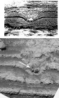
I imagine something like this, with changes in the water table adjusting the area
and extent of the water/land interface over large areas. Tides are out I guess (duh!!!). Are these changes, plus wind-induced waves capable of forming the festoons?
(Source image) |
|
|
|
|
|
|
Jun 18 2007, 05:01 PM
Post
#16
|
|
|
Merciless Robot Group: Admin Posts: 8784 Joined: 8-December 05 From: Los Angeles Member No.: 602 |
I don't know if tides could be considered as part of the issue at this point, $0.02. We don't know what the possible depth & volume of any waters @ Meridiani might have been, and of course the only significant tidal influence would be solar...difficult to reconstruct a plausible scenario with the limited data we have.
-------------------- A few will take this knowledge and use this power of a dream realized as a force for change, an impetus for further discovery to make less ancient dreams real.
|
|
|
|
|
Jun 18 2007, 05:17 PM
Post
#17
|
|
|
Senior Member Group: Members Posts: 3419 Joined: 9-February 04 From: Minneapolis, MN, USA Member No.: 15 |
Not to belabor a point, but it gets down to how you exercise the scientific process.
Gravitation, terrestrial crustal movement and even diversification and radiation of species are not theoretical, they are observed phenomenah. They are objectively, empirically observable. The mechanisms involved in how they operate are theoretical. (This is the argument I get into with my girlfriend... )You cannot open your assumptions so broadly that you begin to treat empirical observations as unproven theories. That sabotages the scientific process and leads to festoons of tin-foil hats... -the other Doug -------------------- The trouble ain't that there is too many fools, but that the lightning ain't distributed right. -Mark Twain
|
|
|
|
|
Jun 18 2007, 06:08 PM
Post
#18
|
|
|
Senior Member Group: Members Posts: 2173 Joined: 28-December 04 From: Florida, USA Member No.: 132 |
QUOTE (dvandorn @ Jun 18 2007, 01:17 PM) You cannot open your assumptions so broadly that you begin to treat empirical observations as unproven theories. The festoons are "objectively, empirically observable". The "mechanisms involved" in how they form are theoretical. I don't think anyone is arguing those points. I'm curious about what theories are out there concerning how the water flow (that caused the festoons according to the water flow formation theory) occurred. Wind? Rising and falling water tables on a slope? Maybe it is no problem for wind blowing over shallow water to form such festoons. I don't know. |
|
|
|
|
Jun 18 2007, 06:22 PM
Post
#19
|
|
|
Merciless Robot Group: Admin Posts: 8784 Joined: 8-December 05 From: Los Angeles Member No.: 602 |
QUOTE (centsworth_II @ Jun 18 2007, 11:08 AM) The festoons are "objectively, empirically observable". The "mechanisms involved in how they form are theoretical... Maybe it is no problem for wind blowing over shallow water to form such festoons. I don't know. Yep; there's the real rub: too many undefined variables, and therefore poor constraints on the scope of the problem. We don't know what the conditions were like, and one hell of a lot of legwork is needed to figure that out before even attempting to declare likely explanations for the observations. It does seem as if water was present at some point, but there seems to be precious little objective data that tells us for how long, or how often. -------------------- A few will take this knowledge and use this power of a dream realized as a force for change, an impetus for further discovery to make less ancient dreams real.
|
|
|
|
|
Jun 18 2007, 06:53 PM
Post
#20
|
|
|
Junior Member Group: Members Posts: 63 Joined: 4-May 05 Member No.: 378 |
QUOTE (dvandorn @ Jun 18 2007, 11:17 AM) Not to belabor a point, but it gets down to how you exercise the scientific process. Gravitation, terrestrial crustal movement and even diversification and radiation of species are not theoretical, they are observed phenomenah. No, they are not. The motion of planets, apples and bits of the Earth's surface are observations, the theories which account for them are theories. Hugely successful, taken as reality (or the best available description of it) in the normal course of science, but still theories. And necessarily open to falsification. It seems to me that we need to keep this distinction very clear when we are observing a new world where the basic rules of chemistry and physics remain the same, but the situations are different from what we have previously seen on Earth. Stevo -------------------- Popper: A party entertainment, filled with confetti and a small explosive charge.
|
|
|
|
|
Jun 19 2007, 02:19 AM
Post
#21
|
|
|
Member Group: Members Posts: 384 Joined: 4-January 07 Member No.: 1555 |
Thanks for all the thoughtful replies about water flowing over a horizontal surface, in relation to "festoons". I agree such flow is theoretically possible, just not highly plausible (e.g., why don't you see "festoons" everywhere, across the entire area, if there was sheet flow, with no channels?). I'm reminded of the one about the procrastinating student who tells me he wants to take a make-up test because his grandmother died on the date of the first test and I say fine. Then he tells me the same thing again for the second test, and I think, well, okay, but that's kind of a coincidence. This kid is sure hard on grandmas, and he's all out. Then he comes up to me well after the third test and asks for a third make-up, "because my grandmother died". I say, hey wait a minute, you only had two, and he tells me something like, "well, my grandfather had a sex change operation" or "my father's mom was adopted, so she actually had two different mothers" or "my mom's mom was married to another woman, and my mom was fathered by an anonymous sperm donor" or "my father's family got divorced and remarried an awful lot, so I currently have 10 grandmothers". I think, well that's all theoretically possible, so I have to give him the makeup exam, but is it at all plausible? That's how we came to feel about the coincidences involved in the highly convoluted Meridiani story. Plus it doesn't explain how to form nearly identical-appearing, cross-bedded, sandy, salty, spherule-bearing rocks at Home Plate or anywhere else on Mars.
Making rare little "festoons" or trough-shaped current ripple cross-beds by the odd little eddy or vortex in a turbulent impact surge cloud seems far simpler conceptually. Such small trough shapes do occur in volcanic surge deposits - see figure and discussion in Knauth's 2007 LPSC abstract here: http://www.lpi.usra.edu/meetings/lpsc2007/pdf/1757.pdf Actually, to a field geologist who habitually visualizes things in 3-D, most of the alleged Meridiani "festoons" appear to represent a topographic misinterpretation of a low-angle cross-bedded rock as viewed from above - see figure and discussion here: http://www.lpi.usra.edu/meetings/lpsc2006/pdf/1869.pdf Geologists sometimes call this effect "V-ing upstream". (When viewed from above, the horizontal bedding planes appear to bend up each crack and wrap around each ridge, like contour lines on a topographic map. Think of a person wearing horizontally striped pants, with you looking down at their rump from 5-feet up. The horizontal stripes will look like little troughs: UU.) The 5-foot high rover cameras can't bend down the way a real geologist could, to view the flat-lying beds from the side. Perhaps some of the 3-D image-processing gurus here at UMSF would like to take a stab at the rover "festoon" images to see if we're right or wrong about what look like troughs, but perhaps really aren't. (In other words, I'm asking for your help in discovering and visualizing the truth.) Whatever the results of that important test, there would still be an awful lot of dead grandmothers at Meridiani, if you ask me. BTW, the processes involved in forming impact surge deposits will probably never be as well studied or understood as those for deposition by wind and water. You can't confine a nuclear bomb to a wind tunnel, or to a tilted flume channel. If you want to observe surge deposition up close, you're dead, just like all those alleged grandmas. In the case of terrestrial impacts, fine-grained deposits begin to erode as soon as they're formed, and they're quickly gone. The extremely slow rate of wind erosion on Mars means that fine-grained impact deposits have a much better chance of being buried (and thus preserved) by later geological processes, such as more impacts. That preservation perhaps occurred at Meridiani and Home Plate, if we are correct. --Don |
|
|
|
|
Jun 19 2007, 02:40 AM
Post
#22
|
|
|
Senior Member Group: Members Posts: 3419 Joined: 9-February 04 From: Minneapolis, MN, USA Member No.: 15 |
There is much more data to collect before any theory is proven. I really do appreciate your efforts, Professor. And I surely understand the difficulty in direct observation of large impact events. Even if you eventually are proven wrong, we will always need people to challenge the conventional wisdom, or else misinterpretations will never get addressed!
Thanks again for joining this forum. -the other Doug -------------------- The trouble ain't that there is too many fools, but that the lightning ain't distributed right. -Mark Twain
|
|
|
|
|
Jun 19 2007, 02:42 AM
Post
#23
|
|
 Senior Member Group: Admin Posts: 4763 Joined: 15-March 05 From: Glendale, AZ Member No.: 197 |
QUOTE (dburt @ Jun 18 2007, 06:19 PM) why don't you see "festoons" everywhere, across the entire area, if there was sheet flow, with no channels?) Come on Don, now you're an educated guy. That's a bit like asking why paleontologists don't see fossils all over the Earth considering the widespread history of life here. After billions of years of who-knows-what, of impacts, wind erosion, ices, and even fluids, the region has changed. That we have to look carefully for something as small and fragile as fossilized festoons is not surprising. Their present day abundance is not necessarily indicative of historical conditions. -------------------- If Occam had heard my theory, things would be very different now.
|
|
|
|
|
Jun 19 2007, 05:32 AM
Post
#24
|
|
|
Member Group: Members Posts: 384 Joined: 4-January 07 Member No.: 1555 |
Sorry Elk Grove Dan, I didn't make myself clear. I meant: Why don't we see them continuously exposed at the same preserved level of alleged sheet water flow in areas of adequate outcrop, such as in the wall of a little crater? (Payson outcrop, I believe that area was called.) In that regard, why haven't we seen any water channels at all? Flowing water always seems to find a way to erode channels, especially in soft sand or mud, and channels are the most commonly accepted evidence for regional water flow on Mars images (together with teardrop shaped islands, perhaps). The pictures I saw of terrestrial "festoons" presented at a meeting were all in restricted areas of former waist-deep sheet water flow right next to an enormous river channel. That big river struck me as a little odd as an analog for Meridiani. I've personally seen nice "festoons" exposed only in the same environment, preserved in sandbars on the banks of the Colorado River in the Grand Canyon - again, not a possible analog for Meridiani.
For over 30 years I've taught my freshman classes that a sand-choked water flow will generally take the form of a braided stream, with dozens of little channels branching and rejoining as they make their leisurely way across a nearly flat sandy plain. Those branching and rejoining channels are the only evidence for flowing water I've ever seen on flat sandy surfaces where deposition is occurring. An example I studied on June 1 was at top of the dune-deposited Jurassic Page Sandstone, of Page, Arizona, where it was eroded down to the plane of the water table, and then washed by the water flows that deposited the Entrada Sandstone on top of it. No "festoons" at all - just dozens of little branching channels seen almost anywhere in sandstones on top of that planar erosion surface. Hike the Rim Trail that encircles the town of Page and you'll also see beautiful views over Lake Powell, and tons of hematitic concretions that don't look anything at all like the Meridiani spherules, except that they're kind of round. BTW, ephemeral braided streams are almost universal in sandy flat areas of the modern Arizona desert too, unless we're in the midst of a scouring flash flood. So even if the "festoons" are real and not an unfortunate artifact of viewing angle, 1) something that looks just like them apparently has formed in various surge deposits too and 2) they are a highly atypical indicator of flowing water in a flat sandy environment (sort of like the 3rd dead grandmother in my little parable above). That is, possible but not plausible, and certainly not the best indicator for flowing water (highly ambiguous, as it turns out). Note: I don't consider myself a sedimentologist. Knauth teaches that course and does that research, and I've learned something from him and from a lifetime of field work. I hope I'm not getting too technical for most of you. I'm really trying to avoid that. Oh well, vote with your eyes, I guess, but please let me know. --Don |
|
|
|
|
Jun 19 2007, 06:26 AM
Post
#25
|
|
|
Senior Member Group: Admin Posts: 4763 Joined: 15-March 05 From: Glendale, AZ Member No.: 197 |
QUOTE (dburt @ Jun 18 2007, 09:32 PM) I hope I'm not getting too technical for most of you. Don't know about anyone else but I'm jogging along right next to you Don. I may be rusty on my physics and calculus, and TD is just a painful memory but I've kept my background in geology and geophysics well-polished. -------------------- If Occam had heard my theory, things would be very different now.
|
|
|
|
|
Jun 19 2007, 02:50 PM
Post
#26
|
|
|
Member Group: Members Posts: 401 Joined: 5-January 07 From: Manchester England Member No.: 1563 |
I'm no geologist or chemist but the impact surge argument seems very straight foward and logical, possibly more so than any other hypothesis I've heard. I understand that the chemistry of home plate is very suggestive of the presence of water. Could the chemistry of home plate be accounted for by the impact surge hypothesis alone, or would the occasional presence of water still be required?
-------------------- |
|
|
|
|
Jun 19 2007, 03:05 PM
Post
#27
|
|
|
Senior Member Group: Members Posts: 3419 Joined: 9-February 04 From: Minneapolis, MN, USA Member No.: 15 |
My wonderment with the impact surge theory is how it resulted in the finely layered rocks we've been calling evaporite. That would require, through the 800 meters estimated thickness of the unit, tens of thousands (if not more) separate impact surges, would it not? Each one depositing a millimeter-thick layer with only occasional cross-bedding? And the variations in chlorine and bromine -- those are excellently explained by hydrodynamics. How does impact surge theory explain them?
I see tens of thousands of dead grandmothers lurking here... -the other Doug -------------------- The trouble ain't that there is too many fools, but that the lightning ain't distributed right. -Mark Twain
|
|
|
|
|
Jun 19 2007, 03:34 PM
Post
#28
|
|
|
Senior Member Group: Members Posts: 2173 Joined: 28-December 04 From: Florida, USA Member No.: 132 |
QUOTE (dvandorn @ Jun 19 2007, 11:05 AM) ...the 800 meters estimated thickness of the unit... The mind boggles. Opportunity is looking at the tiniest fraction of the overall history of Meridiani. I don't think the base surge explanation for the festooned layers that Opportunity has seen denies that the overall 800 meter deep stack of evaporites could have been laid down in the bed of an ancient sea. The base surge theory only says that an impact would rearrange that material into the small scale features seen by Opportunity, in the limited range of layers that she is looking at. It's the festoons -- the small smiley-faced ones that it's said could be formed in a matter of hours, or minutes -- that concern me. I think it's legitimate to ask what caused the water flow that would be necessary to form them. What rate of flow is necessary? The way I see it, the berries could very well be concretions formed in water long after the festoons formed, by whatever means. In this case, the berries do not need to be explained by the base surge theory. |
|
|
|
|
Jun 19 2007, 03:52 PM
Post
#29
|
|
|
Senior Member Group: Members Posts: 3419 Joined: 9-February 04 From: Minneapolis, MN, USA Member No.: 15 |
Oh, believe me, I'm grateful for the Professor in bringing up the impact surge theory. Impacts have shaped the surface of Mars moreso than they have of Earth, and any geological analysis that doesn't take that into account is ignoring a bunch of 800-lb gorillas in the room, so to speak.
As for the lack of braided channels in the layers we can see -- that bothers me, too. Always has. I wonder a bit about the movement of water in a lower-gravity environment, and whether or not this could have an effect on channeling in shallow water. But when I look at various images of Meridiani, I do see evidence of mud-cracking-type features (such as Anatolia). Taking everything altogether, Occam's Razor points at water, to me. But I seriously appreciate the concept of alteration by impact processes, since such processes *must* have been occurring throughout the formation of these units. -the other Doug -------------------- The trouble ain't that there is too many fools, but that the lightning ain't distributed right. -Mark Twain
|
|
|
|
|
Jun 19 2007, 04:29 PM
Post
#30
|
|
|
Member Group: Members Posts: 910 Joined: 4-September 06 From: Boston Member No.: 1102 |
In general I think we are talking about standing water, not flowing streams. Is the atmosphere of Mars strong enough to ripple the surface of a lake such that festoons form on a sandy bottom?
-------------------- |
|
|
|
|
Jun 19 2007, 06:55 PM
Post
#31
|
|
|
Senior Member Group: Members Posts: 2173 Joined: 28-December 04 From: Florida, USA Member No.: 132 |
QUOTE (dvandorn @ Jun 19 2007, 11:52 AM) ...when I look at various images of Meridiani, I do see evidence of mud-cracking-type features (such as Anatolia). Taking everything altogether, Occam's Razor points at water, to me. This does not have to be either/or: Water or base surge. Water for the original evaporites. Water for the vugs, concretions, and "mud cracks". I can see all that. But I'd like to see more on how the small, smiling festoons were caused by surface water. |
|
|
|
|
Jun 19 2007, 11:22 PM
Post
#32
|
|
|
Senior Member Group: Members Posts: 1583 Joined: 14-October 05 From: Vermont Member No.: 530 |
QUOTE (dvandorn @ Jun 19 2007, 11:05 AM) My wonderment with the impact surge theory is how it resulted in the finely layered rocks we've been calling evaporite. I wonder if the atmospheric conditions over quite a larger area would gain higher levels of vapor, condensation, precipitation after an impact... given the explanation for frost at the Viking sites involving CO2 precipitation, I won't hazard to guess what materials CO2, H2O, liquid-hot magma, etc are involved. But fine-layering, I'm sure there's some way that's compatible with overlapping clouds of vapor created by various impacts. |
|
|
|
|
Jun 19 2007, 11:41 PM
Post
#33
|
|
|
Member Group: Members Posts: 384 Joined: 4-January 07 Member No.: 1555 |
Nice to hear that my remarks of last night have generated some more discussion. I have to sleep, hug my wife, and do my day job too sometime, so sorry I can't chime in more often. Glad also to discover that I haven't been too technical yet, and that all are following the "dead grandmothers" argument without being a professor or teacher (of course, among us it's a standing joke that grandparents seem to die only on test days).
With regard to some of the preceding comments, at Meridiani and Home Plate the amazing rovers are imaging only the same surface rocks that can be imaged from orbit, but in infinitely more detail and from many more angles, along with multiple instruments that yield compositional and mineralogical-petrological information. The brush and RAT, plus unintended wheel dragging, have been exceedingly helpful too. Still, what lies beneath either site can only be guessed at, except where impacts have excavated samples of deeper rocks. Impact cratering at Victoria Crater has excavated only the same sandy, salty, cross-bedded, spherule-rich rocks seen earlier in Endurance and Eagle craters - no signs whatever of standing water (i.e., no shales or lake beds). Driving into the crater may reveal more (e.g., a detailed record of layering, called stratigraphy by geologists), but it is unlikely to reveal any new rock types. Orbital imaging suggests deeper rocks (nearly a kilometer thick, and therefore potentially much older than those at the surface) are also finely layered, and, most intriguingly, Ken Edgett's 2005 article in the Mars Journal suggests that some of these deeper rocks may contain flow channels of some sort. It would be highly premature to state what geological processes (water, wind, volcanism, impact) might have formed these older, deeper beds without looking at them up close, however. We have never claimed that they are all impact deposits - we have just stated that some or all of them could be, because Edgett also noted that they appear to be interstratified with numerous impact craters, indicating that lots of cratering was going on as they were deposited. Keep in mind that impact deposits can be channeled like any other rock - the channels don't indicate water deposition, only erosion. Also, processes other than water flow can erode channels too, as Nick Hoffman has emphasized in his "White Mars" interpretations of outflow channels and young gullies. There are plenty of gaseous mixtures that, in bulk, have much in common with a watery fluid. (Steamy, high-velocity surge clouds making various types of cross-beds, for example.) Impact cratering inside (or in the region of) Gusev Crater does not appear to have excavated any of the expected lake beds either - just variably vesicular lavas (some or all of which might instead be impact melt - on the surface we see only the broken pieces, not the lava flows) and possible small pieces of layered surge beds. On the other hand, no particularly deep craters have or will be (given its dragging wheel) visited by Spirit. If there were a small explosive volcano nearby, it could have excavated rocks going all the way down to its source region (region of rock melting - very deep indeed). Unfortunately, no volcanic constructs or explosive craters are visible nearby, despite possible volcanic indicators in the cross-bedded surge rocks of Home Plate, which are more likely simply more impact surge (I've made no secret about that being our present interpretation). The above stratigraphic review is just to demonstrate that we haven't made any of the possibly outlandish claims about impact deposits that some people seem to have attributed to us. Our working hypotheses are strictly based on the daily images and published data that has been released to date, and mainly concern the youngest rocks (those exposed at the surface and imaged by the rovers). |
|
|
|
|
Jun 19 2007, 11:52 PM
Post
#34
|
|
 Member Group: Members Posts: 809 Joined: 11-March 04 Member No.: 56 |
QUOTE (dburt @ Jun 19 2007, 11:41 PM) no particularly deep craters have or will be (given its dragging wheel) visited by Spirit Except for that insignificant little depression called "Gusev"... 
|
|
|
|
| Guest_AlexBlackwell_* |
Jun 19 2007, 11:56 PM
Post
#35
|
|
Guests |
QUOTE (dburt @ Jun 19 2007, 01:41 PM) Nice to hear that my remarks of last night have generated some more discussion. I have to sleep, hug my wife, and do my day job too sometime, so sorry I can't chime in more often. You have to learn to put UMSF at the head of the above-listed queue. Of course, then you'd have to add "see a divorce lawyer and go to the unemployment agency" at the end 
|
|
|
|
|
Jun 21 2007, 12:46 AM
Post
#36
|
|
|
Member Group: Members Posts: 384 Joined: 4-January 07 Member No.: 1555 |
QUOTE (marsbug @ Jun 19 2007, 07:50 AM) I'm no geologist or chemist but the impact surge argument seems very straight foward and logical, possibly more so than any other hypothesis I've heard. I understand that the chemistry of home plate is very suggestive of the presence of water. Could the chemistry of home plate be accounted for by the impact surge hypothesis alone, or would the occasional presence of water still be required? Superb question! Really sets me off (the flattery doesn't hurt either ). In principle, what impacts do is vaporize, excavate, and scatter what was already in the target volume, as modified by vapor condensation and generally minor chemical input from the impactor (a comet or meteorite). Turbulent surges also scour the surface across which they flow, possibly modifying the cloud chemistry. Impact doesn't create anything new, except high pressure minerals and impact melt (and vapor and condensates, including spherules) - it's main effect is to homogenize and scatter what was already there.Most salts at Meridiani (except jarosite which, following Roger Burns, we attribute to iron sulfide weathering - impact acid steam condensation has alternatively been suggested by a colleague, Misha Zolotov) probably formed in liquid water (brine) long before impact may have scattered across Meridiani. If early Mars worked like early Earth, the salts mainly date back to shortly after the planet formed, when acid steam, released by planet-wide degassing, condensed into the first warm seas. The acids rapidly reacted with basic rocks like basalt to form neutral salts containing Mg, Ca, and Na. To concentrate the dissolved salts into a dense brine or crystals, we like freezing more than evaporation. That is, given the choice between hot vs. cold for early Mars, we choose cold, because Mars has always been much farther from the Sun and much smaller than Earth. As the seas froze down and the ice sublimated, the brines beneath got more and more concentrated (denser), and gradually sank into the subsurface, where they were trapped beneath ice or permafrost. Whether cold or hot (relatively), early Mars was certainly bashed by impacts, probably most of them just before 3.8 billion years ago (the so-called late heavy bombardment). These impacts obliterated the early surface history of Mars and scattered salts and, we hypothesize, sulfides across the surface. Afterwards, the surface of Mars was about as it is today, extremely cold and dry, with an atmosphere close to a vacuum, so that liquid water (and even ice in most places) was unstable or extremely ephemeral. Large amounts of water apparently survived in the subsurface, however, as both ice and (probably) deep brine (as evidenced by occasional catastrophic releases to outflow channels that possibly formed ephemeral seas in the northern lowlands). We tentatively date the Meridiani surface rocks (= youngest geologically) to the tail end of the late heavy bombardment period, when the surface of Mars already could not support liquid water as streams or lakes (given that there is no geological evidence of any at Meridiani - in this our interpretation differs completely from that of the MER team). The surface climate matters very little for the impact process itself, but does affect the preservation potential (cold and dry = very slow wind erosion only, allowing weak Meridiani sediments, cemented only by soluble salts, to survive until the next distant impact buried and preserved them). So to answer your question (you say, at last!), no liquid water is indicated by the salts, other than minor quantities resulting from condensation of steam in the original surge cloud, or whatever the salts themselves could attract from the atmosphere (i.e., water in surface brine films and occasional drips). This minor water was enough to rust sulfides and dissolve (leach) the most soluble salt (probably a chloride), leaving hollow crystal cavities, but was not enough to crystallize clays, destroy jarosite, recrystallize the soluble salts in bulk (reducing rock permeability to zero), or form the extremely coarse (giant in places) salt crystals that characterize actual evaporites or other water-soaked salt deposits. Our impact surge hypothesis resembles the extremely complex one of the MER team only in that we agree that the salts must have been transported from somewhere else (a realization they apparently came to only after we had pointed out to them, in our initial "brine splat" presentations of 2004, conceptual problems with having the most soluble and least soluble salts intimately mixed together in an alleged evaporite). That "somewhere else" could be any large salt concentration in the subsurface for us, or a hypothetical giant vanished playa lake (for which there is absolutely no surface or shallow subsurface evidence at or near Meridiani) for them. Our hypothesis can be generalized to any sandy, salty, layered sequence on Mars (including Home Plate in Gusev Crater), theirs cannot. Our allows for the actual appearance and extremely broad distribution of "blueberries" as impact-derived spherules (with similar-appearing ones occurring at Home Plate and probably many other places); theirs does not. And so on and so on, but I hope you are getting the general idea. I emphasize that the above impact story is merely a working hypothesis that undoubtedly is wrong in some details, but in its present form it appears consistent with all available evidence (I trust everyone will feel free to disagree vociferously). Wow, ask a simple question and get a simplified geological history of Mars! What a deal! Oh well, you know me by now. As Arne said in T2, "Of course, I'm a terminator", I say "Of course, I'm a herr doktor professor" (who kills grandmothers by his tests, and every else by his long lectures...).
|
|
|
|
|
Jun 21 2007, 01:07 AM
Post
#37
|
|
|
Merciless Robot Group: Admin Posts: 8784 Joined: 8-December 05 From: Los Angeles Member No.: 602 |
...you're killing me, Professor; none of my profs ever had a sense of humor like this... One quick question re the 'ancient salts' hypothesis: What about the atmospheric effects of comparatively recent vulcanism such as the Tharsis Uplift? (IIRC, that's thought to have happened 100-200 MY BPE). It seems reasonable to assume that most of the outgassing was CO2 and water accompanied by a rise in atmospheric pressure (how much & for how long, no idea...though the Big Four are, like, big, so thinking that this had to go on for some time). Anyhow, what I'm wondering is how apparently water-soluable salts could have survived near the surface during this epoch; certainly atmospheric water vapor should have penetrated the surface below the first few inches of the soil. This makes me think that these deposits were produced later in Martian history after vulcanism subsided and the atmosphere devolved into its present state. -------------------- A few will take this knowledge and use this power of a dream realized as a force for change, an impetus for further discovery to make less ancient dreams real.
|
|
|
|
| Guest_AlexBlackwell_* |
Jun 21 2007, 01:09 AM
Post
#38
|
|
Guests |
QUOTE (nprev @ Jun 20 2007, 03:07 PM) ...you're killing me, Professor; none of my profs ever had a sense of humor like this...Yes, laughing at the professor's jokes is one way of improving your grade
|
|
|
|
|
Jun 21 2007, 01:23 AM
Post
#39
|
|
|
Merciless Robot Group: Admin Posts: 8784 Joined: 8-December 05 From: Los Angeles Member No.: 602 |
Oh, yeah...but I don't have to force it here!
-------------------- A few will take this knowledge and use this power of a dream realized as a force for change, an impetus for further discovery to make less ancient dreams real.
|
|
|
|
|
Jun 21 2007, 01:41 AM
Post
#40
|
|
|
Senior Member Group: Members Posts: 2173 Joined: 28-December 04 From: Florida, USA Member No.: 132 |
QUOTE (dburt @ Jun 20 2007, 08:46 PM) Our hypothesis can be generalized to any sandy, salty, layered sequence on Mars... theirs cannot. Our [hypothesis] allows for the actual appearance and extremely broad distribution of "blueberries" as impact-derived spherules...theirs does not. And so on... So when is some geological society going to host a conference where proponents of these theories can face off. It would be good to get more geologists with varied expertise and experience weighing in. |
|
|
|
|
Jun 21 2007, 01:55 AM
Post
#41
|
|
|
Senior Member Group: Members Posts: 2998 Joined: 30-October 04 Member No.: 105 |
QUOTE ...no liquid water is indicated by the salts, other than minor quantities resulting from condensation of steam in the original surge cloud, or whatever the salts themselves could attract from the atmosphere (i.e., water in surface brine films and occasional drips). This minor water was enough to rust sulfides and dissolve (leach) the most soluble salt (probably a chloride), leaving hollow crystal cavities, but was not enough to crystallize clays, destroy jarosite, recrystallize the soluble salts in bulk (reducing rock permeability to zero), or form the extremely coarse (giant in places) salt crystals that characterize actual evaporites or other water-soaked salt deposits. You are wrong. --Bill -------------------- |
|
|
|
|
Jun 21 2007, 02:09 AM
Post
#42
|
|
|
Senior Member Group: Members Posts: 2173 Joined: 28-December 04 From: Florida, USA Member No.: 132 |
QUOTE (dburt @ Jun 20 2007, 08:46 PM) ...no liquid water is indicated by the salts, other than minor quantities... And besides the large amounts of liquid water involved in the original formation of the salts, right? QUOTE (dburt @ Jun 20 2007, 08:46 PM) If early Mars worked like early Earth, the salts mainly date back to shortly
after the planet formed, when acid steam, released by planet-wide degassing, condensed into the first warm seas. The acids rapidly reacted with basic rocks like basalt to form neutral salts containing Mg, Ca, and Na. |
|
|
|
|
Jun 21 2007, 02:52 AM
Post
#43
|
|
|
Member Group: Members Posts: 384 Joined: 4-January 07 Member No.: 1555 |
QUOTE (centsworth_II @ Jun 19 2007, 11:55 AM) This does not have to be either/or: Water or base surge. Water for the original evaporites. Water for the vugs, concretions, and "mud cracks". I can see all that. But I'd like to see more on how the small, smiling festoons were caused by surface water. A "mud crack" is formed in mud, by definition. No layer of mud (called shale when hardened into a rock) has yet been imaged anywhere at Meridiani, so far as I know. Therefore, no mud cracks. (This term has not, so far as I'm aware, been used by the MER team.) The polygonal cracks that affect the layered rocks have been called "bulk shrinkage cracks" and can occur in various types of rocks - what environment they indicate is therefore ambiguous. They could indicate drying (shrinking) of clays (as in mud), dehydration of salts, a response to temperature decrease (like columnar jointing in lavas - vertically oriented bulk shrinkage cracks whose orientation is controlled by the flat geometry of the flow as it cools and shrinks), or some other process. FWIW, polygonal bulk shrinkage cracks are common in sandy, cross-bedded surge deposits (which of course is what we believe Meridiani consists of). Such shrinkage presumably occurs as the rocks cool and they lose the steam that permeated the them during deposition. See Knauth's 4th figure here: http://www.lpi.usra.edu/meetings/lpsc2006/pdf/1869.pdf We were together when he took that photo; I've seen similar shrinkage cracks in other surge deposits. As per salts implying water, see my above "terminator" post (not if the salts were formed earlier and then transported to Meridiani, which is one interpretation we agree with the MER team on). As per the alleged "festoons", see my post of a day or two ago - "festoons" need not indicate flowing water, because they apparently can form in surge deposits too (a different type of flow), and most at Meridiani may simply be an artifact of viewing angle (which I'm still hoping someone here can confirm or prove wrong). "Festoons" are a cross section through "current ripple marks" (tiny moving sand dunes, conceptually) and form in a manner distinct from "oscillation ripple marks" which form in very shallow water due to the influence of surface waves on the water. Only minor water, such as liquid condensed from the steamy surge cloud or water attracted from the air by the salts itself, is needed to leave the Meridiani crystal cavities (again, see my "terminator" post). (BTW, the technical adjective for salts that attract water - most do - is hygroscopic or, in extreme cases such that a salt attracts so much water that it liquifies in place - self dissolves, as it were - is deliquescencent.) Calcium chloride, probably a common salt inside Mars, is deliquescent, and it is commonly used in laboratories as a drying agent because it sucks so much moisture out of the air. And of course, the only water needed to form what the MER team calls "concretions" is condensing steam (or another vapor) in a surge cloud, if they are impact-related spherules (as their perfectly spherical shape, uniformly tiny size, Ni-enrichment, blue-gray color, and pattern of distribution suggests). Please prove me wrong.  --Don |
|
|
|
|
Jun 21 2007, 02:54 AM
Post
#44
|
|
|
Member Group: Members Posts: 384 Joined: 4-January 07 Member No.: 1555 |
QUOTE (centsworth_II @ Jun 20 2007, 07:09 PM) And besides the large amounts of liquid water involved in the original formation of the salts, right? You got it. Lots of water somewhere, somewhen, but not at Meridiani then (or since). --Don |
|
|
|
|
Jun 21 2007, 03:28 AM
Post
#45
|
|
|
Senior Member Group: Members Posts: 2173 Joined: 28-December 04 From: Florida, USA Member No.: 132 |
QUOTE (dburt @ Jun 20 2007, 10:54 PM) Lots of water somewhere, somewhen, but not at Meridiani then (or since). Why assume that the salts did not form at Meridiani billions of years ago. Is it only because they had to form somewhere else in order to be moved to Meridiani by base surge? |
|
|
|
|
Jun 21 2007, 04:25 AM
Post
#46
|
|
|
Member Group: Members Posts: 384 Joined: 4-January 07 Member No.: 1555 |
QUOTE (nprev @ Jun 20 2007, 06:07 PM) ...you're killing me, Professor; none of my profs ever had a sense of humor like this...One quick question re the 'ancient salts' hypothesis: What about the atmospheric effects of comparatively recent vulcanism such as the Tharsis Uplift? (IIRC, that's thought to have happened 100-200 MY BPE). It seems reasonable to assume that most of the outgassing was CO2 and water accompanied by a rise in atmospheric pressure (how much & for how long, no idea...though the Big Four are, like, big, so thinking that this had to go on for some time). Anyhow, what I'm wondering is how apparently water-soluable salts could have survived near the surface during this epoch; certainly atmospheric water vapor should have penetrated the surface below the first few inches of the soil. This makes me think that these deposits were produced later in Martian history after vulcanism subsided and the atmosphere devolved into its present state. Owing to plate tectonics, Earth probably has at least as much volcanism today as Mars ever did, plus coal-burning power plants and smelters are continously tossing a sulfuric acid precusor (SO2) into the air. This has minor effects (such as slight climate cooling - which we badly need in Phoenix) but the ground hardly is littered with jarosite, gypsum or other relatively insoluble sulfates. Consider early degassing of an entire molten planet, compared with the little bit of steam and CO2 and SO2 that comes out of a lava flow or even volcanic steam explosion - a drop in the bucket, literally. As I understand it (not my field), the atmospheric pressure on Mars is close to "buffered" by CO2 ice at the poles and in fact Mars has been continuously losing atmosphere very slowly since the end of the late heavy bombardment. Evidence for climate change is mainly blamed on obliquity and orbital variations (how much Mars tilts on its axis and how non-circular its orbit is). Some people try very hard to make Mars temporarily warm and wet with volcanism, which may be possible, given how little atmosphere there is to begin with, but I imagine that this effect could be dwarfed ty the effect of a large impact (especially during the boom boom boom of the late heavy bombardment). Impact was adequate both to warm Mars up (very temporarily) and deposit thick layers of salty sediments. As should be obvious from my abbreviated history, I'm with the very wet, but very cold and salty school of early Martian geology (at least until more information becomes available). Show me the palm trees, I say, before I bring my swimming suit. The fact that water soluble salts have survived near the surface is just what makes me think that it hasn't rained on those parts of Mars in 3.8 billion years - or at least, not much. (Snow or frost is okay for survival of sulfates - see below.) In Arizona, after a small rainstorm (something else we badly need), the sulfates on mine dumps sink into the ground owing to dissolution and then, over the next several weeks, they reappear as colorful crusts referred to efflorescences (because they can look like flowers blooming). I think that's what we're seeing in the cauliflower-like crusts of salts being imaged just below the surface at and near Home Plate. The low pressure makes the salts effloresce just beneath, rather than above, the surface. The driving force is simple capillarity and evaporation of moisture - dip a paper towel into salty water, the water rises up (wicks up) by capillarity, and then evaporates, leaving salts behind - far above the surface of the water. And many salts generate their own brine from atmospheric moisture, so that capillarity can make deep salts wick upwards towards the surface, without rain. This effect was much discussed with regard to formation of "sulfate duricrust" during Viking days, but seems to have been largely neglected in recent discussions. My general attitude (Occam's razor) is I don't want to invoke any unusual effect or phenomenon, especially anything I can't see direct evidence of, until I am forced to by the data. That's how I feel about "warm, wet" early Mars - it seems to me that impact alone, for which there's abundant evidence at every scale, may suffice for a lot of what people want to blame volcanism, or greenhouse gases, or whatever on. Occam was apparently a medieval theologian (and logician) who got upset when people wanted to blame every event or phenomenon on mysterious, invisible angels. I feel the same way about invisible geological features (missing playas and missing volcanoes) on Mars. BTW, if you want surface water under present martian surface conditions, just dissolve lots of salts in it (mainly chlorides, not sulfates - the sulfates litter the surface, and the chlorides don't, because the sulfates have very little abilty to depress the freezing point of ice). If frost lands on mixed salts, the chlorides are leached, and the sulfates are not. Knauth and I published papers on that in 2002 and 2003, as mentioned in a previous post, I think, and blamed the crystal cavities at Meridiani on the same phenomenon in our 2005 Nature paper. Playing the professor again, I'm afraid. All out of jokes, though.  --Don |
|
|
|
|
Jun 21 2007, 04:29 AM
Post
#47
|
|
|
Member Group: Members Posts: 384 Joined: 4-January 07 Member No.: 1555 |
QUOTE (centsworth_II @ Jun 20 2007, 06:41 PM) So when is some geological society going to host a conference where proponents of these theories can face off. It would be good to get more geologists with varied expertise and experience weighing in. Ever hear of the "lunatic fringe"? That's us, in most people's eyes.
|
|
|
|
|
Jun 21 2007, 04:32 AM
Post
#48
|
|
|
Member Group: Members Posts: 384 Joined: 4-January 07 Member No.: 1555 |
QUOTE (Bill Harris @ Jun 20 2007, 06:55 PM) You are wrong. --Bill Quite probably, but how? (Despite being a professor, I am teachable, I hope.) |
|
|
|
|
Jun 21 2007, 04:50 AM
Post
#49
|
|
|
Senior Member Group: Members Posts: 3419 Joined: 9-February 04 From: Minneapolis, MN, USA Member No.: 15 |
QUOTE (dburt @ Jun 20 2007, 11:25 PM) ...missing volcanoes ...on Mars. Ummm... if the Tharsis shield volcanoes and dozens of other classic calderas readily observed on Mars aren't volcanoes, and if the very clear and obvious lava flows (which read as basalt from both surface and orbital spectral analysis) aren't volcanic, then what are they? I hate to say this, but if your theories are based even a little tiny bit on this "observation" that Mars is "missing volcanoes," then you do seem to be ignoring empirical data (labeling it "theoretical") that doesn't fit with your own theories, and that's when the scientific method fails. I'm sorry -- I simply *must* have misinterpreted what you mean, here, since that statement is so obviously false. -the other Doug -------------------- The trouble ain't that there is too many fools, but that the lightning ain't distributed right. -Mark Twain
|
|
|
|
|
Jun 21 2007, 05:41 AM
Post
#50
|
|
|
Member Group: Members Posts: 384 Joined: 4-January 07 Member No.: 1555 |
QUOTE (centsworth_II @ Jun 20 2007, 08:28 PM) Why assume that the salts did not form at Meridiani billions of years ago. Is it only because they had to form somewhere else in order to be moved to Meridiani by base surge? Good question. If I understand it, your argument is they had to form somewhere, so why not at Meridiani, where we find them? (Great example of Occam's razor at work, by the way.) I don't want to write another long post, because I'm about to go home, but maybe I can practice with a short one. The basic arguments are several: 1) We see no evidence of a geological environment that would permit salts to grow at the surface - no shales, meaning no standing water for an evaporite basin or even puddle - not even in deep material excavated from Victoria. The playa lake, if any, has "vanished". 2) The Meridiani salts appear to be an intimate mixture of highly soluble and highly insoluble salts (a mechanical mixture, in other words) plus poorly characterized fine debris (not crystalline clays). Salts crystallize out of an evaporite basin in inverse order of solubility - least soluble first, in a "bathtub ring" around the outside fringe (usually gypsum), and then more and more soluble salts in zones towards the center. Meridiani is nothing like this. The MER team agrees with us that the salts had to come from somewhere else - they invoke wind transport and mixing (reasonable - plenty of wind on Mars), we invoke impact transport and mixing (plenty of evidence of impacts, of all ages, but especially for early Mars). 3) The salts are very fine grained and the rocks appear uniformly porous and permeable. Growth from water, or soaking in water, would have caused permeability decrease and crystal size increase. This argues strongly against the MER team interpretation that the salty rocks were soaked in brine many times after they were deposited, and that brine mixing in a huge, uniformly permeable volume produced concretions. (The US Government permanently stores military radwaste in evaporitic salt beds, because they are so impermeable.) There are other more subtle geochemical arguments, but those 3 are the easiest to understand, I think. Let me know if you need clarification. Well, out to play in the real desert (i.e., go home) . Soon the daily summer afternoon dust storms (haboobs) will begin in Phoenix (sort of a very dilute, relatively slow-moving, cool, dry analog for a ground-hugging surge cloud - but something that a martian surge cloud could easily decay into with distance, perhaps). Thank y'all very for your comments (even you, Bill Harris - I really admire your succinctness ). --Don |
|
|
|
|
Jun 21 2007, 03:10 PM
Post
#51
|
|
|
Senior Member Group: Members Posts: 2173 Joined: 28-December 04 From: Florida, USA Member No.: 132 |
QUOTE (dburt @ Jun 21 2007, 01:41 AM) Let me know if you need clarification. Ok, everyone agrees that the sulfates were moved to their present location from elsewhere. I'm wondering about the very fine layering seen at Meridiani. I have a hard time imagining such fine layers being formed by such a violent, sudden activity like base surge. Do you have any feeling for what depth of layering would be attributable to a single base surge event? Apart from the fine scale festoons that the MER team attributes to water, there are the massive chunks that really do look like fossil dunes (or large wind ripples). Do you also attribute those to base surge? Even assuming that the layers and berries could be the result of base surge, I have a hard time understanding the formation of the large crystals whose dissolution formed the vugs. You've said: "No more moisture is required than would be present in the original surge cloud (mainly condensing steam) or could later be removed from the atmosphere by water-attracting (hygroscopic or deliquescent) salts." And: "Only minor water, such as liquid condensed from the steamy surge cloud or water attracted from the air by the salts itself, is needed to leave the Meridiani crystal cavities" Is the formation of such large in-ground crystals by trace water (on Earth) a geological observed fact? Or is it a "fringe" hypothesis? I have no real geological background. |
|
|
|
|
Jun 21 2007, 03:59 PM
Post
#52
|
|
|
Senior Member Group: Members Posts: 3419 Joined: 9-February 04 From: Minneapolis, MN, USA Member No.: 15 |
Yes -- I brought up the finely layered nature of the rocks at Meridiani before, and that question was never addressed by the Professor. I can see these rocks being built up by aeolian deposition of millimeter-deep layers over the course of tens of thousands of years, laid down on wet ground (and possibly onto shallow standing water), far more than I can see tens of thousands of base surges, each laying down a very thin, very flat layer of rock of consistent composition to the last base surge, each laying down a very flat, very thin layer with almost no turbulence developing along the surge/ground contact.
Such surges would, I would think, have enough energy in them that we would see scouring and channeling -- the very same types of landforms whose lack that the Professor cites as a disproof of standing water or a playa environment. If these layers were laid down by an energetic base surge, how can they be so overwhelmingly flat, with very little sign of any turbulence? (Remember, the cross-bedding we've seen is the exception, not the rule, in these rocks.) Are you postulating that there were *no* surface features that would have caused turbulence in the surge/ground contact? (We may not be able to watch and observe a surge in detail, but we have a ton of similar surge-emplaced landforms that we have observed in great detail on the Moon, and even with a lack of atmosphere, we see evidence of a fantastic amount of turbulence in the debris flows that generated terrain on Luna.) I also have a difficult time understanding how these deposits could have been laid down at the end of the Late Heavy Bombardment. There is visual evidence supporting the theory that the rough, cratered terrain generated by the LHB actually underlies the Meridiani deposits. You'd have to assume, based on the range of crater-like landforms, the relative lack of large craters, and the relative flatness of the terrain, that the nearly kilometer of Meridiani deposits were laid *after* the LHB had finished. In other words, if the Meridiani unit was generated by tens of thousands of impacts at the end of the LHB, why would the unit not have been broken up by these impacts as quickly as the base surges laid it down? What makes Meridiani so special that it could be laid down by impacts all around it but not suffer any impacts in the area itself, thus leaving this layered unit (which would have required millions of years of base surges to lay down) mostly intact? Occam's razor suggests that we're seeing an entire population of dead grandmothers here... -the other Doug -------------------- The trouble ain't that there is too many fools, but that the lightning ain't distributed right. -Mark Twain
|
|
|
|
|
Jun 21 2007, 10:51 PM
Post
#53
|
|
|
Member Group: Members Posts: 384 Joined: 4-January 07 Member No.: 1555 |
QUOTE (dvandorn @ Jun 20 2007, 09:50 PM) Ummm... if the Tharsis shield volcanoes and dozens of other classic calderas readily observed on Mars aren't volcanoes, and if the very clear and obvious lava flows (which read as basalt from both surface and orbital spectral analysis) aren't volcanic, then what are they? I hate to say this, but if your theories are based even a little tiny bit on this "observation" that Mars is "missing volcanoes," then you do seem to be ignoring empirical data (labeling it "theoretical") that doesn't fit with your own theories, and that's when the scientific method fails. I'm sorry -- I simply *must* have misinterpreted what you mean, here, since that statement is so obviously false. -the other Doug You got me. Sorry, I guess I should have explained myself much better. I didn't mean the giant Tharsis and similar basaltic volcanoes, which are nowhere near Meridiani, and are non-explosive (Hawaiian style flowing lava only, in general). I meant the small "invisible" exploding volcano presumed by the MER team to have produced the surge deposits at and near Home Plate (that type of steam explosion generally leaves a highly visible crater or construct - consider Diamond Head in Honolulu, which is of this type - and the deposits are usually very local, extending only few kilometers). I also meant the likewise "invisible" but necessarily very much larger Yellowstone Park-style "supervolcano", that McCollom and Hynek (2005, in the same Nature issue as our impact paper) hypothesized for producing Meridiani. Perhaps they saw the recent Discovery Channel film "Supervolcano." It has an excellent depiction of a giant volcanic surge cloud from Yellowstone killing several geologists fleeing in a truck, wheras their boss, in a helicopter high overhead, survives because the flow was hugging the ground. A similar volcanic surge cloud is depicted towards the end of the film "Dante's Peak". No such giant exploding supervolcanoes have yet been documented on Mars, to my knowledge, although various people have called upon them to produce layered deposits. Impacts, for which there is abundant evidence, seem more logical to me. You mean you can't read my mind?  --Don |
|
|
|
|
Jun 22 2007, 12:00 AM
Post
#54
|
|
|
Senior Member Group: Members Posts: 3419 Joined: 9-February 04 From: Minneapolis, MN, USA Member No.: 15 |
That makes sense, Don -- though IIRC, isn't there a large, heavily eroded caldera structure in the middle of Meridiani Terra, which (in global terms) lies adjacent to Meridiani Planum? Could be a source of volcaniclastic materials in the Meridiani Planum area, could it not?
I'm still interested in how you explain the finely layered nature of the rocks seen at Oppy's landing site (and, by inference, the entire 800m thick Meridiani unit). And I'd love to see computer simulations of the turbulence at the surge/ground contact... -the other Doug -------------------- The trouble ain't that there is too many fools, but that the lightning ain't distributed right. -Mark Twain
|
|
|
|
|
Jun 22 2007, 12:28 AM
Post
#55
|
|
|
Member Group: Members Posts: 384 Joined: 4-January 07 Member No.: 1555 |
QUOTE (centsworth_II @ Jun 21 2007, 08:10 AM) I'm wondering about the very fine layering seen at Meridiani. I have a hard time imagining such fine layers being formed by such a violent, sudden activity like base surge. Do you have any feeling for what depth of layering would be attributable to a single base surge event? Apart from the fine scale festoons that the MER team attributes to water, there are the massive chunks that really do look like fossil dunes (or large wind ripples). Do you also attribute those to base surge? Even assuming that the layers and berries could be the result of base surge, I have a hard time understanding the formation of the large crystals whose dissolution formed the vugs. You've said: "No more moisture is required than would be present in the original surge cloud (mainly condensing steam) or could later be removed from the atmosphere by water-attracting (hygroscopic or deliquescent) salts." And: "Only minor water, such as liquid condensed from the steamy surge cloud or water attracted from the air by the salts itself, is needed to leave the Meridiani crystal cavities" Is the formation of such large in-ground crystals by trace water (on Earth) a geological observed fact? Or is it a "fringe" hypothesis? I have no real geological background. Excellent questions. I'll start with the fine layering. That fine layering and cross-bedding was what most astonished me the first time I was exposed to volcanic surge deposits in Utah, while studying volcanic rocks as possible sources for uranium (under a government-university contract) in the late 1970's. The deposits had been misidentified as "water laid tuff" for about 15 years by a few Geological Survey employees, who couldn't believe it either (they ignored the lava flows on top, which might have suggested volcanism). Of course, they were mineral deposit types and sedimentologists who had never studied volcanoes before, whereas I cheated by having a leading expert on explosive volcanism (former ASU Prof. Mike Sheridan) with me at the time, which unfairly helped the diagnosis. Co-author, Ken Wohletz, a doctoral student at the time, was along and did his ASU Ph.D. thesis on surge deposits, before he was hired at Los Alamos. (BTW, a 1983 paper by Wohletz and Sheridan first suggested that Mars rampart crater ejecta should be examples of impact surge deposits.) While I'm recounting history, in the mid-1950's Gene Shoemaker (who later became world famous for his studies of impact cratering) started out studying volcanic surge surge deposits in New Mexico and Arizona (looking for uranium too) before returning to school to complete a Ph.D. dissertation on Meteor Crater, AZ. He couldn't believe the giant sandy cross beds (dune forms) he saw were caused by explosive volcanism either, and initially attributed them to wind action. (Even most volcanologists were making similar mistakes in that era.) Since then studies by numerous volcanologists (clued in by nuclear bomb tests, where surges and their cross-bedded deposits were first described) have documented that thin bedding, low-angle cross-bedding, high angle cross-bedding, dune forms, and ripple forms can occur in surge deposits, all features that excellently mimic wind or water deposition. Both air and water are fluids that carry solids. Evidently, a hot, turbulent suspension of divided solids in a rapidly-moving gas cloud behaves as a fluid too. The stickiness that condensing steam gives to particles apparently can help them be deposited more rapidly than normal sediments (truly wet surge deposits can be plastered onto the side of trees). Some terrestrial surge deposits appear so ambiguous that non-volcanologists are still arguing with volcanologists over volcanic vs. wind-caused deposition - and those are the deposits that occur next to a crater (information from Wohletz). The extremely poor sorting (mixture of large and small pieces), together with the cross-bedding and fine layering, is fairly diagnostic of surge deposits close to the explosion site, but sorting increases with distance, so that a mainly sandy deposit can be hard to diagnose. Bomb sags, caused by ballistic ejecta of rocks by the explosion, have been used to diagnose volcanic surges (e.g., at Home Plate), but ballistic ejecta are also typical of impacts. Disseminated accretionary lapilli resembling the Meridiani "blueberries" (except in composition) are common in some volcanic surge deposits, and would never be expected in a wind- or water-deposited sediment. (Post depositional concretions tend to be much more irregularly sized, shaped, and distributed than accretionary lapilli.) The thickness of the deposits depends on the size (magnitude) and distance of the explosion - but several meters to several tens of meters are typical of volcanic deposits, where the explosions involved much less energy release than a decent-sized impact releases. For very small volcanic surge deposits (such as those protected from erosion by overlying basalt flows at Peridot Mesa, AZ) you can hike out and follow the gradual transition from several 10's of meters of coarse, cross-bedded ejecta (containing blocks 1 m or more across) to a thin deposit only a few cm thick, consisting of well-sorted fine sand - still finely layered, with shrinkage cracks resembling those at Meridiani. As for large, in-ground crystals: I invite you to go to an Arizona rock shop and buy a "desert rose". These are fairly large crystals (up to many cm across) that form in damp desert soil from the little moisture available. They are made of gypsum, hydrated calcium sulfate, a salt mineral reported from Meridiani (the least soluble one). Or take some wall-board, which is made of fine gypsum, moisten it in a jar for a few weeks, and watch it "rot" as it recrystallizes (as wall-board in a home will do if made damp for too long). I haven't carried out this experiment: let me know the results if you try it. We hypothesized that the Meridiani crystal cavities were caused by some type chloride salt crystals that grew right after surge deposition, when things were still warm and very damp - early diagenesis, a sedimentologist might call it. Leaching could have occurred later, by frost. That's all for now - got to go to a meeting. Hope this answers your questions. --Don |
|
|
|
|
Jun 23 2007, 01:12 AM
Post
#56
|
|
 Senior Member Group: Members Posts: 1229 Joined: 24-December 05 From: The blue one in between the yellow and red ones. Member No.: 618 |
QUOTE (dburt @ Jun 21 2007, 02:28 PM) Excellent questions. I'll start with the fine layering. ---snip--- That's all for now - got to go to a meeting. Hope this answers your questions. --Don Prof Don, First let me thank you for the time you have taken to explain your hypothesis and clarify questions from our members. Let me also compliment you on the lucid arguments you have prepared. I find it hard to imagine that many of your students would need to participate in the exam-week "Slaughter of the Innocents", given the clarity of your explanations. That said, I must suggest that your answer above has tended to skirt the issue of the laminated structure of the Burns Formation as it relates to impacts. Your interesting anecdotes do an excellent job of showing how explosive volcanism on Earth could produce laminated, even cross-bedded, sediments of a similar appearance, and I, for one, would agree entirely with such an alternate cause if there were a range of stratovolcanos evident on the margins of the Meridiani Planitia. A series of wind-blown ash clouds from cyclic eruptions or periodic pyroclastic flows might produce something like a Burns Formation, given a long enough volcanic history, but, as you indicate, this kind of vulcanism is not prominent on Mars. Of course, the accumulated ash would grow enormously thicker and more pronounced than the Burns layers as one approached the source volcanos. I think the MOC imagery would have revealed some trace of this by now. But that is quite apart from the question as to whether bolide impacts could produce an accumulation of ejecta resembling the Burns Formation. Many of us have a real problem with that. Impacts do form layered ejecta, but generally not more than two or three layers per impact, and these layers are usually quite distinctive lithologically. I think there are about three detectable in the mid North American continent from the Chicxulub impact. The lowermost from the high velocity jets of ballistic ejecta, the middle from the fallback surge of the collapsing ejecta column, and the third from the slow rain of fine distal fallout re-entering the atmosphere globally. We can see scores to hundreds of layers in the lower parts of the Victoria capes. They are remarkably uniform in scale and appearance. Since a rain of meteorites would distribute more or less randomly over Mars, it is hard to credit that some would not land closer to Meridiani and produce much thicker (meter-scale) layers, as can be seen in the Caribbean environs of Chicxulub. It is hard to imagine that the coarser proximal ejecta would not appear anywhere in the series, excepting the Victoria ejecta at the surface. In many ways this argument is analogous to that which you make for blueberries. How can there be so many, so uniform and limited in size range? Actually I have less trouble believing that a broad, uniform plain of well-mixed thin sand layers, as Meridiani may once have been, could, when exposed to brief episodes of uniform wetting with very limited supplies of slow-moving groundwater, produce a crop of very uniform concretions with very limited growth, before the Big Freeze-Dry stopped everything but the wind. Furthermore, the berry distribution through the evaporite is even, as might be expected from a growth process strictly confined by a limited supply of solute, rather than random or aggregated as might be expected for accretionary lapilli being tossed and hurled by the violent currents of an impact surge. I am sure that the MER team model for Meridiani leaves some questions unanswered, but I still think it leaves fewer than the impact or volcanic alternatives. I don't have the chemistry expertise to deal with those issues, but as I drive around the Meridiani Planitia, courtesy of my good friend Opportunity, I get the sense that this has been one of the quieter, more-peaceful corners of Mars for much of its history. It's been a nice place to sit and ponder. Cheers, Shaka -------------------- My Grandpa goes to Mars every day and all I get are these lousy T-shirts!
|
|
|
|
|
Jun 23 2007, 05:43 AM
Post
#57
|
|
|
Member Group: Members Posts: 384 Joined: 4-January 07 Member No.: 1555 |
QUOTE (dvandorn @ Jun 21 2007, 08:59 AM) I can see these rocks being built up by aeolian deposition of millimeter-deep layers over the course of tens of thousands of years, laid down on wet ground (and possibly onto shallow standing water), far more than I can see tens of thousands of base surges, each laying down a very thin, very flat layer of rock of consistent composition to the last base surge, each laying down a very flat, very thin layer with almost no turbulence developing along the surge/ground contact. Such surges would, I would think, have enough energy in them that we would see scouring and channeling -- the very same types of landforms whose lack that the Professor cites as a disproof of standing water or a playa environment. If these layers were laid down by an energetic base surge, how can they be so overwhelmingly flat, with very little sign of any turbulence? (Remember, the cross-bedding we've seen is the exception, not the rule, in these rocks.) Are you postulating that there were *no* surface features that would have caused turbulence in the surge/ground contact? (We may not be able to watch and observe a surge in detail, but we have a ton of similar surge-emplaced landforms that we have observed in great detail on the Moon, and even with a lack of atmosphere, we see evidence of a fantastic amount of turbulence in the debris flows that generated terrain on Luna.) I also have a difficult time understanding how these deposits could have been laid down at the end of the Late Heavy Bombardment. There is visual evidence supporting the theory that the rough, cratered terrain generated by the LHB actually underlies the Meridiani deposits. You'd have to assume, based on the range of crater-like landforms, the relative lack of large craters, and the relative flatness of the terrain, that the nearly kilometer of Meridiani deposits were laid *after* the LHB had finished. In other words, if the Meridiani unit was generated by tens of thousands of impacts at the end of the LHB, why would the unit not have been broken up by these impacts as quickly as the base surges laid it down? What makes Meridiani so special that it could be laid down by impacts all around it but not suffer any impacts in the area itself, thus leaving this layered unit (which would have required millions of years of base surges to lay down) mostly intact? Occam's razor suggests that we're seeing an entire population of dead grandmothers here... -the other Doug You raise a lot of excellent points, other Doug, which clearly indicate careful thought. I'll try to take them in order. The fine layering I already addressed in a previous post - it is highly typical of surges and for me was their most surprising feature. Deposits laid down solely on wet ground owing to stickiness probably would not be cross-bedded (as every layer seen to date in Meridiani is). Sedimentts deposited in standing (as opposed to flowing) water would never be cross-bedded and would be likely to be fine mud instead of sand unless they were deposited right at the shore or during a sandstorm. The lack of mud beds (shales) and universality of cross-bedding provide our main basis for stating that Meridiani sediments contain no record of standing water (i.e., no playa is possible, at least not to the depth of exposure/excavation in Victoria or the other craters visited by Oppy). To make cross-bedding, you need erosion (scouring) followed by deposition. For the wind, this is how sand dunes migrate - they are eroded on one side and the sand is then redeposited on the other side, giving you the giant, high-angle cross beds typical of old dune fields. Dunes (and, for wet and sticky enough particles, antidunes, where the dune grows upwind) are also common in surges. Flowing water making current ripples (so-called "festoons") works the same way, but on a smaller scale. Similar-appearing features can also form in surges, apparently, although they appear to be comparatively rare. Most cross bedding in surge deposits is at very low angles, because the particles are generally moving very fast ("whoosh!"). Low angle cross bedding dominates the Meridiani sediments, consistent with surge deposition, but probably not wind. As for scouring, inasmuch as every cross bed is a record of scouring, I presume you really meant just to ask about channels. Local channels are highly typical of many areas of surge deposition. They usually are attributed to a swirling vortex (part of the turbulence) moving radially outward from the explosion. Linear, radial channels in volcanic surge deposits (such as those resulting from the 1980 eruption of Mt. St. Helens, WA) have been documented by, e.g, Grant Heiken and Sue Kieffer. By our hypothesis of impact surge deposition, the linear grooves visibly radiating outwards from a great many Mars impact craters (as imaged by both MOC and Themis) would be evidence of just such vortices in an impact surge cloud. Burns Cliff itself appears to contain an example of such a scour - it occurs just beneath what the MER team called the "Wellington Contact" and is near the center of, e.g., this raw image from Sol 287: http://marsrovers.jpl.nasa.gov/gallery/all...MIP2270L5M1.JPG Unfortunately Oppy was unable to examine this scour up close, but I saw similar appearing scours while examining various surge deposits in Oregon last summer (described by Grant Heiken and visited by Apollo astronauts, in case some lunar craters turned out to be volcanic). The MER team interpretation is that the "Wellington Contact" is a former water table of regional extent (although it has only been imaged only in Burns Cliff), and the dune-deposited sand was wind-eroded down to this planar water table. How the wind could erode such a localized channel BELOW the water table was never addressed, to my knowledge. (The eroded channel is unlikely to be a stream channel, because it contains no coarse material at the bottom, plus it would be conceptually difficult for water OR wind to erode a stream channel below the water table.) Since they made this suggestion, I have examined several former water tables in exposures of the Navajo and Page Sandstones of Arizona, and I have never seen such a channel feature - the contacts are planar, commonly with shale along them where there was local standing water. That's also where lots of hematitic concretions tend to occur, all clumped together in planar masses. Our impact interpretation would be that the "Wellington Contact" is just a large cross-bed, perhaps marking the contact between two successive surge clouds, with the localized scour marking a turbulent vortex in the younger surge cloud. If so, finding such channels on opposite sides of a given crater exposure might indicate a direction radially towards or away from the parent impact crater (something to look for if Oppy successfully enters Victoria). Your age question I would answer somewhat speculatively by saying that there has been considerable wind erosion of fines in the past 3.8 billion years. Surge clouds usually are energetic enough to ride up over highlands and settle in lowlands (as notably happened in mountainous areas near Mt. St. Helens in 1980, as today evidenced by the pattern of downed trees). The deposits in highlands tend to be thin and to consist mainly of fines, whereas the lowlands deposits are thick and coarse (more resistant to erosion). In other words, the fluid-like surge clouds tend to "pond" in relatively low areas, despite their energy and high velocity, because they are density currents. The Meridiani lowlands were, in addition, selectively protected from later erosion by their "desert pavement" of dense, unusually large (1-5 mm) hematitic impact-related spherules, which may have been lacking or abraded away in the nearby highlands (pure speculation). BTW, areas of layered deposits in the nearby cratered highlands are reported by Edgett (2005), in his thoroughly-documented article in the first issue of the on-line Mars Journal. As mentioned in a previous post, Edgett also documents that cratering was concurrent with deposition of the main Meridiani sequence (and that some of the lower layers appear to be channeled). With regard to flatness - the wind has done a pretty good job of keeping the terrain flat by erosion (clearly visible at Victoria - look at what happened to the coarse fragments of ejecta); Edgett earlier predicted this from orbital imaging. Also, as mentioned above w.r.t. erosion, although surge clouds can override obstacles (unlike liquids like water or lava), they also tend to fill in lowlands ("pond") and, along with later wind erosion/deposition, could have covered up older or coeval craters. With regard to comparisons with the Moon: The extremely important difference between Mars and the Moon is that Mars had an atmosphere and lots of suburface brine or ice at the time of late heavy bombardment (and still does today, to a lesser amount). In the dry vacuum of the Moon, impact implies predominantly ballistic processes (like fragments shot from a cannon) no matter how small the particle. The only vapor formed was vaporized impactor and vaporized silicate rock, and these vapors apparently condensed almost instantly into tiny glass spherules. It has been suggested that particle-to particle interactions in a vacuum could have produced a gas-like surge cloud on the Moon, but, to my knowledge, no such finely layered deposit was ever spotted by the Apollo astronauts (who were specifically trained to look for them). Constant "gardening" by micro impacts may have degraded any exposures, however (whereas Mars has enough of an atmosphere to largely protect it from most such "impact gardening" - at the outcrop scale, at least.) On Mars the impact vapors must have contained lots of steam (and vaporized salts), allowing turbulent surge clouds to form that in many ways resembled those formed by smaller explosive volcanic eruptions, where the dominant gas involved is also steam. As each turbulent, scouring, particle-rich surge cloud flowed radially outwards along the ground, it mixed with the atmosphere and decompressed and cooled. Steam (and probably vaporized salts) then condensed onto particle surfaces, making them sticky, and causing them to stick together and agglomerate or acrete into spherules called "accretionary lapilli" (a possible origin for the Meridiani "blueberries" - like a tiny rolled snowball made of sticky particulate rock). In this regard, the so-called rampart craters appear to be unique to Mars, and have always been attributed to either the subsurface volatiles ice or brine or the atmosphere (people still argue - Mars scientists will argue about anything ).That's rather a long post, but then you asked rather a lot of questions (all great ones, BTW). I agree with you that there are far too many "dead grandmothers" (a.k.a. implausibilities) still associated with the various Meridiani hypotheses (not unusual for Mars). We arrived at the impact hypothesis by the process of elimination - impact seemed to offer fewer implausibilities than either wind/water or volcanism. For example, if Mars wind today can only erode a few meters per billion years, how could it have deposited nearly a kilometer of sediments at Meridiani? And if all those sediments are sulfate-rich, you might have to evaporate a playa lake deeper than Olympus Mons is tall (sulfates aren't all that soluble). I'll stick with the impact hypothesis for now - impact seems like the only process able to do all the work required (until a better idea comes along). Also, as mentioned in an earlier post, we cannot exclude water, wind, or volcanism in any combination as having contributed to the unstudied deeper layers at Meridiani or anywhere else, although we suggest that they might not much be needed. Impact surge isn't the only plausible depositional process associated with impacts (ignoring the obvious ballistic ejecta, think about all the dust produced! and all the steam! and all the gases other than steam! and all the heat! and all the melt!) - it's just the only one that seems to explain the sandy, salty, cross-bedded, spherule-bearing beds imaged by the first two rovers at both Meridiani and Home Plate, on opposite sides of the planet. It also predicts that similar salty, cross-bedded, spherule-bearing beds could be found at the surface by later rovers (HiRISE imaging, as did earlier MOC imaging, suggests such layers could be common). The most elegant and marvelously detailed Meridiani hypothesis (vanished, highly acid playa lake/wind/soaking acid water/more wind/more soaking acid water/deep flowing - but never standing - concentrated acid brine/magically-diluting-and-mixing water), even if you ignore all of its special assumptions and internal inconsistencies (such as why cold water crystallized the high temperature, blue-gray form of hematite, and why that hematite should be enriched in Ni, and why the soluble salts never recrystallized, and many more I haven't mentioned), at best predicts and explains nothing at all about anywhere else, not even about the almost identical appearing beds at Home Plate. So when is someone going to give me a hard time about Home Plate? (Although I'm perfectly willing to try to revive more "dead grandmothers" at Meridiani, if I can... )--Dr. Don |
|
|
|
|
Jun 23 2007, 04:21 PM
Post
#58
|
|
|
Senior Member Group: Admin Posts: 4763 Joined: 15-March 05 From: Glendale, AZ Member No.: 197 |
QUOTE (dburt @ Jun 22 2007, 09:43 PM) For example, if Mars wind today can only erode a few meters per billion years, how could it have deposited nearly a kilometer of sediments at Meridiani? I think it's more than a little disingenuous of you to assume constant rates of erosion over 3.8 billion years, in of all places, Mars. That Mars has experienced a history of varied atmospheric densities isn't even in dispute. Indeed I can't image your "surge cloud theory" working under present 6 millibar conditions unless you admit that atmospheric densities were higher in the past. And of course in that case we are looking at higher rates of erosion and deposition. (I also believe that the .38g on Mars will contribute to a much stranger movement of particle masses than has occurred in the Cascades, but I'm not prepared to wade into that debate right now.) Don, you have some interesting ideas and your theories are certainly contributing to the discussions, but a lot of this minuscule "evidence" you cite is a bit tortured. Sort of like finding a candy wrapper and declaring "children were here!" I think you've killed off more than a few grandmothers yourself on this thread. -------------------- If Occam had heard my theory, things would be very different now.
|
|
|
|
|
Jun 24 2007, 12:53 AM
Post
#59
|
|
|
Member Group: Members Posts: 809 Joined: 11-March 04 Member No.: 56 |
What does this "kilometer of sediments" refer to? Is that supposed to be the depth of the stratigraphy? How could we know it actually goes that deep?
Sorry for the ignorant question, I just feel I'm missing something here... |
|
|
|
|
Jun 24 2007, 12:58 AM
Post
#60
|
|
|
Member Group: Members Posts: 384 Joined: 4-January 07 Member No.: 1555 |
[quote name='Shaka' date='Jun 22 2007, 06:12 PM' post='93253']
...your answer above has tended to skirt the issue of the laminated structure of the Burns Formation as it relates to impacts. [/quote] See my discussion of surge deposit textures that was posted after you wrote this. Fine laminations and low angle cross-bedding, presumably caused by shear, characterize many surge deposits, despite their rapid deposition. Early in Mars history, there seems no limit to how many distant impacts could have contributed to the layering, although one big one might have been enough. Unlike with volcanism, impacts can occur anywhere, anywhen, into any available target, from a variety of possible impactor types, and be of any size (up to destroying the planet). A single volcanic surge eruption can result in many meters of section, containing many dozens of layers, varying in character between dune-like and relatively flat-bedded, with some containing disseminated accretionary lapilli and some not. Kilbourne Hole, New Mexico is a famous example of such a deposit, with slopes that resemble Burns Cliff, and dune forms that Gene Shoemaker initially ascribed to wind. [quote name='Shaka' date='Jun 22 2007, 06:12 PM' post='93253'] ...explosive volcanism on Earth could produce laminated, even cross-bedded, sediments of a similar appearance, and I, for one, would agree entirely with such an alternate cause if there were a range of stratovolcanos evident on the margins of the Meridiani Planitia. [/quote] I am reduced to citing volcanic analogs because, to be frank, no one has seen a surge formed by an impact (except presumably the dinosaurs and pterosaurs, who didn't live to tell about it), on this planet or any other. Impact deposits on this planet (except the coarse fraction - commonly called suevite if it is glassy) are weathered and eroded virtually immediatedly, unless they settle on the ocean, in which case they are water reworked, resorted, and highly hydrated (the fragmentary record of Chicxulub, the dinosaur-terminating impact, is largely written in gummy clay pseudomorphs). Owing to its dry, cold, near-vacuum conditions for most or all the past 3.8 billion years, Mars may turn out to be the best place in the Solar System to preseve a record of impact processes on a planet with subsurface volatiles and an atmosphere. Volcanoes, on the other hand, on Earth explode almost every week or month somewhere, so surge processes can be observed, and deposits can be fresh and unaltered, plus older deposits are commonly preserved under a capping lava flow, scoria deposit, or ignimbrite (welded ash flow tuff). Stratovolcanoes, as you probably know from your use of the word, would not be expected anywhere on Mars, owing to the lack of plate tectonics (they generally form only above subduction zones), nor would Yellowstone Park caldera-type supervolcanoes, because there is no hydrous granitic crust for a mantle plume to melt. In any case, even if Meridiani were a record of such an eruption, we'd might never know it, because the surge beds would probably be buried beneath a much thicker layer of erosion-resistant ignimbrite (welded tuff). [quote name='Shaka' date='Jun 22 2007, 06:12 PM' post='93253'] ...But that is quite apart from the question as to whether bolide impacts could produce an accumulation of ejecta resembling the Burns Formation. Many of us have a real problem with that. Impacts do form layered ejecta, but generally not more than two or three layers per impact, and these layers are usually quite distinctive lithologically. I think there are about three detectable in the mid North American continent from the Chicxulub impact. The lowermost from the high velocity jets of ballistic ejecta, the middle from the fallback surge of the collapsing ejecta column, and the third from the slow rain of fine distal fallout re-entering the atmosphere globally. [/quote] Your guess is as good as mine - because, like all scientific hypotheses, ours an informed guess with considerable evidence to support it and apparently nothing impossible (like a little boy claiming his grandmother was an ant or an elephant instead of merely dead on a test day) against it. Chicxulub, for which a highly imperfect record is recorded in a few spots fairly close by, impacted into the sea, with a rock target of layered carbonate rocks and anhydrite, on a planet with a strong gravity field and a relatively dense atmosphere, so it may not be representative of Mars processes. [quote name='Shaka' date='Jun 22 2007, 06:12 PM' post='93253'] ...We can see scores to hundreds of layers in the lower parts of the Victoria capes. They are remarkably uniform in scale and appearance. Since a rain of meteorites would distribute more or less randomly over Mars, it is hard to credit that some would not land closer to Meridiani and produce much thicker (meter-scale) layers, as can be seen in the Caribbean environs of Chicxulub. It is hard to imagine that the coarser proximal ejecta would not appear anywhere in the series, excepting the Victoria ejecta at the surface. [/quote] Congratulations! You have put your finger right on the weakest aspect of the impact surge argument. This group is really as sharp as I'd hoped it would be! I can answer you in several possible ways, none completely satisfactory. 1) Oppy has imaged only a small portion of the Meridiani layers, those at the very top, which, being the youngest, could have formed when impacting had tailed off, and been distant (its lack of coarse surface material was, after all, what moved it to the top of possible landing site choices - it's possibly a biased sample, in other words). Coarse ejecta or surge layers may lie below the layers exposed, or may even be exposed somewhere deep in Victoria. Such a finding (of coarse pieces) would still be ambiguous, however, because ballistic ejecta could in theory land anywhere on Mars, at any time, on top of any type of sediment (and dust could settle, but it wouldn't stick around, unless the surface were sticky). 2) Coarse surface ejecta has been found at each landing site to date (and at others abandoned from consideration when too many surface boulders were found). Also, coarse layers of boulders in the midst of fine layers have been imaged by HiRISE in various spots - as noted by Emily in the post that inspired me to stop lurking here about a week ago. Finally, in its rush to get to Victoria (and not get stuck again), Oppy by-passed several areas of coarse broken rock imaged at a distance by the Pancam. These appeared to be lag deposits, and could imply wind erosion of a coarse layer stratigraphically just above the layers now exposed. 3) Sand grains carried by the wind whipping across the plain of Meridiani would eventually plane off and erode any coarse ejecta, unless it were buried - look at what has happened to the coarse ejecta blanket of Victoria (I admit that, given the slow rate of erosion on Mars, this is kind of like my arguing to teacher that my third dead grandma had an unusual sexual preference for the time or my grandpa had a sex change operation). 4) Perhaps my best answer is to simply cite William K. Hartmann, in his marvelous 2003 book "A Traveler's Guide to Mars", as noting that impact into sand or soft sandy sediments is going to mainly scatter more sand. (I don't have the book here at home, but I believe he used the phrase "produce a kablooey of sand and dust" which is not a bad description of a turbulent surge cloud.) In other words, by the end of the late heavy bombardment, much of Mars may have been so beat up that many impacts were "beating a dead horse" in terms of producing coarse ejecta.But hey, each kid (or hypothesis in this case) is allowed up to two dead grandmothers, isn't he? This is only the first that I'm aware of. (Note, we can't allow two per author, because that would give the Athena Science team an unfair advantage, although, IMHO, they might have exceeded their allowance even with that unfair method of counting.)[quote name='Shaka' date='Jun 22 2007, 06:12 PM' post='93253'] ...In many ways this argument is analogous to that which you make for blueberries. How can there be so many, so uniform and limited in size range? Actually I have less trouble believing that a broad, uniform plain of well-mixed thin sand layers, as Meridiani may once have been, could, when exposed to brief episodes of uniform wetting with very limited supplies of slow-moving groundwater, produce a crop of very uniform concretions with very limited growth, before the Big Freeze-Dry stopped everything but the wind. ...Furthermore, the berry distribution through the evaporite is even, as might be expected from a growth process strictly confined by a limited supply of solute, rather than random or aggregated as might be expected for accretionary lapilli being tossed and hurled by the violent currents of an impact surge. [/quote] I obviously can't stop you from believing what you want, but I thought I'd already covered this in previous posts, to a certain extent. I've spent much of my life looking for signs of fluid flow (mainly of hydrothermal fluids) and so far none have been imaged at either landing site, IMHO. (White deposits in surface cracks don't count because, like white desert caliche in cracks, they mainly indicate capillary action of moisture near the surface - an expected finding in the presence of water-attracting, soluble salts.) On the other hand, I can go anywhere in the Navajo (or Page) Sandstones, cited by the MER team and Marjorie Chan as a Mars analog, and see that the distribution of hematitic concretions (all red-brown and never blue-gray, of various sizes and shapes, commonly clumped together in nodular masses) is related to brine mixing and flow - distribution along former water tables, along fractures, both cutting across and along specific bedding planes, sudden lateral terminations, etc.). This distribution bears no resemblance to that at Burns Cliff or elsewhere. If you put a less dense brine on top of a more dense brine, as the MER team proposes formed hematite from jarosite, it will sit there essentially forever - diffusion is possible over at most a meter or two in a sandy aquifer (water-saturated porous, permeable rock). How thick is Burns Cliff, which appears to be "spheruled" throughout? If you inject a less dense brine into a more dense brine from below, it will simply rise to the top as a plume, and you have the same problem again. How do you uniformly mix such brines across an area the size of the state of Oklahoma? It shouldn't even be possible in one place. (I trust some hydrologists will back me up in this.) Besides which, as mentioned in previous posts, rocks so rich in soluble salts should become impermeable owing to recrystallization within a very short time of being immersed in a saturated brine. In our 2005 Nature article, Knauth described how presumed layered impact spherules (altered accretionary lapilli, as for Chicxulub, about 5 mm in diameter, as for Meridiani) in Archean (oldest known terrestrial) layered rocks are widely and uniformly distributed across areas of South Africa and Australia comparable to the Meridiani hematite area. Therefore, impact still seems like a far more reasonable process than brine mixing to scatter uniformly tiny hematitic spherules across such a wide area. I would be willing to wager that, no matter where future landers might land, no hematitic spherules or small groups of spherules larger than could be supported in a turbulent surge cloud will be found. (Of course, Oppy may prove me wrong as soon as it enters Victoria, or it may find some shale layers suggesting standing water (or compressed loess, deposits of airborne-dust), but right now I'd be willing to bet against either possibility. Note: some exceptionally big hailstones, such as those in the US national news last week, are large enough to break car windshields. I suspect that the Meridiani "hematite hailstones" (if that's what they really are) may themselves represent an exceptionally coarse deposit, judging from their apparent uniqueness on the martian surface.) [quote name='Shaka' date='Jun 22 2007, 06:12 PM' post='93253'] ...I am sure that the MER team model for Meridiani leaves some questions unanswered, but I still think it leaves fewer than the impact or volcanic alternatives. I don't have the chemistry expertise to deal with those issues, but as I drive around the Meridiani Planitia, courtesy of my good friend Opportunity, I get the sense that this has been one of the quieter, more-peaceful corners of Mars for much of its history. It's been a nice place to sit and ponder. [/quote] We weren't there 3.8 billion years ago, and neither was Oppy. Everything since has been pretty calm, perhaps, but no more so than across most of the rest of Mars. (As mentioned above, if it hadn't been a calm spot since then, Oppy wouldn't have landed there. Also, remember what Bill Hartmann said about a kablooey of sand likely obscuring part of the cratering record.) BTW, please excuse any typos in this and several previous posts. These are proofread by no one, least of all me. I say that because doing these posts is an exercise like taking a very, very long essay exam, and I don't want you taking any points off for my poor proofreading. (Writing essays is something I haven't had to do for 40 years or so, and back then it was all in longhand.) Lots of role reversal going on here, and this group has some potentially great professors!  --Don |
|
|
|
|
Jun 24 2007, 01:43 AM
Post
#61
|
|
|
Member Group: Members Posts: 384 Joined: 4-January 07 Member No.: 1555 |
QUOTE (ElkGroveDan @ Jun 23 2007, 09:21 AM) I think it's more than a little disingenuous of you to assume constant rates of erosion over 3.8 billion years, in of all places, Mars. That Mars has experienced a history of varied atmospheric densities isn't even in dispute. Indeed I can't image your "surge cloud theory" working under present 6 millibar conditions unless you admit that atmospheric densities were higher in the past. And of course in that case we are looking at higher rates of erosion and deposition. (I also believe that the .38g on Mars will contribute to a much stranger movement of particle masses than has occurred in the Cascades, but I'm not prepared to wade into that debate right now.) Don, you have some interesting ideas and your theories are certainly contributing to the discussions, but a lot of this minuscule "evidence" you cite is a bit tortured. Sort of like finding a candy wrapper and declaring "children were here!" I think you've killed off more than a few grandmothers yourself on this thread. Elk Grove Dan - I didn't make up the rates of erosion - they were order of magnitude quotes (from my admittedly increasingly faulty memory) based on numbers published by Matt Golombek et al. for the MER landing sites, with Meridiani, if I recall correctly, being slightly faster than Gusev (it's not in a crater and the rocks are softer). In any case, no more than 10 meters or so ever removed from either rover site in nearly 4 billion years - sort of hard to get used to for we terrestrials. (Note that long term burial in, e.g., drifting sand, followed by recent erosion, could likewise minimize observed erosion.) The atmospheric density probably varied considerably, but it was still a near-vacuum (the difference is between hardly any and not much at all). Most people who study Mars rampart craters believe that the presence of subsurface volatiles is more important than the density of the atmosphere, because the impact vaporizes its own local atmosphere (mainly steam) to make the turbulent flow called a surge. The greater density of the surge is provided by the particulates. A lower atmospheric pressure might allow the surge to run out further and faster, but also would favor more rapid steam condensation, meaning the surge would "run out of steam" (literally). This is the explanation offered by Wohletz and Sheridan in 1983 for rampart crater deposits as surge deposits (most others favored some sort of mud sploosh at the time). The weak gravity of Mars presumably likewise enables longer runout distance for Mars surge clouds (other things being equal, which they never are), but such modeling is still in its infancy. BTW, what if I had discovered that hypothical candy wrapper (Meridiani exposures, in this case) on the day after Halloween? (formed right after 3.8 billion years ago, in this case) And the ground was coverd with tiny footprints? (millions of little and big impact craters, in this case). Would you still think I was jumping to conclusions? So please specify those "dead grandmothers". Shaka pointed out a pretty good one, I thought, related to an apparent lack of coarse material at Meridiani - can you point out a second or third implausibility (based on logic, like he did - not based on the way we might feel things ought to work on another planet, based on our terrestrial predjudices)? And remember, I should be allowed at least one more. Or better yet, specify some impossibilities. Then I can hand in my essay exam and get it graded. Thanks, Prof.  --Don |
|
|
|
|
Jun 24 2007, 04:31 AM
Post
#62
|
|
|
Senior Member Group: Members Posts: 2173 Joined: 28-December 04 From: Florida, USA Member No.: 132 |
QUOTE (David @ Jun 23 2007, 08:53 PM) What does this "kilometer of sediments" refer to? Is that supposed to be the depth of the stratigraphy? How could we know it actually goes that deep? From satellite images of eroded terrain around the Meridiani region in which hundreds of meters of layering can be seen. Below are links to a couple of articles. http://www.space.com/scienceastronomy/0606..._meridiani.html http://www.psrd.hawaii.edu/Mar03/Meridiani.html |
|
|
|
|
Jun 24 2007, 04:43 AM
Post
#63
|
|
|
Member Group: Members Posts: 809 Joined: 11-March 04 Member No.: 56 |
QUOTE (centsworth_II @ Jun 24 2007, 04:31 AM) From satellite images of eroded terrain around the Meridiani region in which hundreds of meters of layering can be seen. Below are links to a couple of articles. Great, thanks -- but how do we know that these layers are of the same type as the relatively short column we see at Victoria, formed by the same process -- which I gather is what Dr. Burt is claiming? |
|
|
|
|
Jun 24 2007, 01:07 PM
Post
#64
|
|
|
Senior Member Group: Members Posts: 2173 Joined: 28-December 04 From: Florida, USA Member No.: 132 |
QUOTE (dburt @ Jun 21 2007, 08:28 PM) ....Gene Shoemaker (who later became world famous for his studies of impact cratering)....couldn't believe the giant sandy cross beds (dune forms) he saw were caused by explosive volcanism either, and initially attributed them to wind action. (Even most volcanologists were making similar mistakes in that era.) Since then studies by numerous volcanologists (clued in by nuclear bomb tests, where surges and their cross-bedded deposits were first described) have documented that thin bedding, low-angle cross-bedding, high angle cross-bedding, dune forms, and ripple forms can occur in surge deposits, all features that excellently mimic wind or water deposition. Are any of these "numerous volcanologists" coming forward to support the credibility of your claims? You mentioned that the surge theory was considered "lunatic fringe". How can that be if the sorts of things that Opportunity is seeing are well documented in surge deposits from explosive events on Earth? Is there even much discussion about this going on in geological circles? Are there any that privately say you have a point or even agree with you but do not want to "go public"? I'd love to see an "is Pluto a Planet?"-style public debate go on even though that was about terminology more than basic science. |
|
|
|
|
Jun 24 2007, 01:19 PM
Post
#65
|
|
|
Senior Member Group: Members Posts: 2173 Joined: 28-December 04 From: Florida, USA Member No.: 132 |
QUOTE (David @ Jun 24 2007, 12:43 AM) Great, thanks -- but how do we know that these layers are of the same type as the relatively short column we see at Victoria, formed by the same process -- which I gather is what Dr. Burt is claiming? Dr. Burt would probably hope to see layers different from those seen in Victoria. Note the recent exchange with Shaka (see below). Maybe MRO can get a closer look at those layers. Shaka: "...We can see scores to hundreds of layers in the lower parts of the Victoria capes. They are remarkably uniform in scale and appearance. Since a rain of meteorites would distribute more or less randomly over Mars, it is hard to credit that some would not land closer to Meridiani and produce much thicker (meter-scale) layers...." dburt: "Congratulations! You have put your finger right on the weakest aspect of the impact surge argument.... I can answer you in several possible ways, none completely satisfactory. 1) Oppy has imaged only a small portion of the Meridiani layers, those at the very top, which, being the youngest, could have formed when impacting had tailed off, and been distant (its lack of coarse surface material was, after all, what moved it to the top of possible landing site choices - it's possibly a biased sample, in other words). Coarse ejecta or surge layers may lie below the layers exposed, or may even be exposed somewhere deep in Victoria. Such a finding (of coarse pieces) would still be ambiguous, however, because ballistic ejecta could in theory land anywhere on Mars, at any time, on top of any type of sediment (and dust could settle, but it wouldn't stick around, unless the surface were sticky). 2) Coarse surface ejecta has been found at each landing site to date (and at others abandoned from consideration when too many surface boulders were found). Also, coarse layers of boulders in the midst of fine layers have been imaged by HiRISE in various spots - as noted by Emily in the post that inspired me to stop lurking here about a week ago. |
|
|
|
|
Jun 24 2007, 01:40 PM
Post
#66
|
|
|
Senior Member Group: Members Posts: 2173 Joined: 28-December 04 From: Florida, USA Member No.: 132 |
QUOTE (dburt @ Jun 23 2007, 01:43 AM) So when is someone going to give me a hard time about Home Plate? Speaking for myself, I'm operating on a very intuitive level here, not having much knowledge and no expertise in geology. The base surge hypothesis is counter intuitive at Meridiani and so raises the most questions in my mind. It was so simple to see things the way the MER team described it. At Home Plate, things seem a lot more complicated, even for the MER team. In the Columbia Hills, even Steve Squyres has mentioned the possibility that rock alterations were the result of volcanic steam. I don't know if he would include impact steam as an alternative. In any case, the formation of the Home Plate area is hypothesized to be the result of violent processes. It's less of a stretch from volcanic to impact hypotheses for Home Plate than it is from water/wind to impact at Meridiani. |
|
|
|
|
Jun 25 2007, 11:20 AM
Post
#67
|
|
|
Member Group: Members Posts: 384 Joined: 4-January 07 Member No.: 1555 |
QUOTE (centsworth_II @ Jun 24 2007, 06:07 AM) Are any of these "numerous volcanologists" coming forward to support the credibility of your claims? You mentioned that the surge theory was considered "lunatic fringe". How can that be if the sorts of things that Opportunity is seeing are well documented in surge deposits from explosive events on Earth? Is there even much discussion about this going on in geological circles? Are there any that privately say you have a point or even agree with you but do not want to "go public"? You're pretty perceptive. Yes, many agree in private, but for entirely obvious reasons they don't want to stick their necks out. And my use of "lunatic fringe" can be thought of as a triple pun on 1) lunatic, 2) luna (no self-respecting Mars geologist would ever admit that Mars resembles the Moon in as many ways as it is different - might be bad for funding), and 3) Gerald Wasserburg's "lunatic asylum" lab at Caltech, which is where many of the Apollo samples were dated by the rate of decay of their contained uranium and other radioactive elements. There were two huge scientific surprises yielded by the Apollo program (not counting the expected result that impact rather than volcanism caused lunar craters). One was that returned lunar rocks were dry as a bone (unlike terrestrial lavas and other igneous rocks, which are relatively hydrous); this dryness and lack of much of a lunar core was later explained by the giant impact theory of the origin of the Moon (that the Moon was formed by a Mars-sized impactor that hit the early Earth a more-than-glancing blow). The other was that all the lunar impact melts (a few other rocks were older, whereas surface lavas were younger) all seemed to have formed at about the same time, 3.9 to 3.8 billion years ago. The "lunatics" hypothesized a "lunar cataclysm" or late heavy bombardment, which had almost erased the record of everything earlier. The modelers of the time couldn't deal with such a unique event (they favored a geometric decay scheme, somewhat analogous to radioactive decay, so that half of the impactors would be swept up by the planets in a given time, then half of those remaining, then half of those remaining, and so on until 3.8 billion years ago - such a model couldn't handle a sudden huge increase in impactors very late in the game). Modelers, because they are held by most people to be "smarter" than observationists (who, I guess, are supposed to be robots like beloved old Oppy), commonly rule popular opinion in science, despite observational evidence to that contradicts their ideas (look up the history of determining the age of the Earth from cooling rates, or of what happened to Wegener's definitive field evidence proving "continental drift" in the 1920's for examples of the influence of modelers on scientific progress). More than 35 years late, the modelers have apparently caught up with those early Apollo results (which, because they could not be modeled, were not widely accepted then or later) - see, e.g., this balanced discussion by Jeff Taylor: http://www.psrd.hawaii.edu/Aug06/cataclysmDynamics.html The majority of traditional Mars geologists seem as yet unaware of the probability of a late heavy bombardment in inner planet history and its implications, some of which were noted in passing by Jeff. For example, he noted that the late heavy bombardment neatly explains why the oldest continental fragments known on Earth are about 3.8 billion years old, although he didn't mention that the Earth, with its much stronger gravity field, should have been hit by far more impactors than the Moon. Also not mentioned: Mars, all alone in its immediate region of the Solar System, and with a stronger gravity field than the Moon, probably was hit much worse too. Jeff does mention the possibility that catastrophic impacting could have caused catastrophic rainstorms on early Mars, thereby neatly explaining drainage networks on some of the oldest, most highly cratered areas of Mars. If such rains ever fell, many of the lower layers at Meridiani could represent water-reworked impact debris, stripped from the nearby highlands (that would help with the total thickness problem, which some have objected to in this thread - although the tendency of surge deposits to pond in lowlands works too, at least for me, with wind stripping fines from the nearby highlands). The impact surge hypothesis strictly applies to only the uppermost rocks at Meridiani, those imaged and measured by the rover (plus many similar areas imaged from orbit on Mars, plus, of course, Home Plate). The observed abundance of soluble Mg-sulfates and the lack of stream channels probably rules out much rain at that time (although it doesn't necessarily rule out cold frost or snow, which would tend to leach only chlorides - see my earlier post). The observations also come close, IMHO, to ruling out the magnificently detailed model arrived at by the MER team, as described in earlier posts (hey, at least we agree that it didn't rain and that the odd salt mixture requires transport from elsewhere). BTW, "model" is the operative word - not "discovery," as it was reported by the popular press, journals that should know better, and the freshman textbook I currently use. What was "discovered" was some salty crossbeds containing tiny blue-gray hematitic spherules, and even that discovery represented considerable interpretation of raw spectral and analytical data. [...Darn preachy old professor! Almost as bad as that guy on the Bad Astronomy website, 'cept he's younger...] If impact on Mars is the proverbial "elephant in the living room" that no one wants to look at or mention (except for dating younger surfaces and determining possible depths to ice), wasn't there another tale involving an elephant and a group of blind men (or, aaah, was it a group of highly specialized distinguished scientists, each afraid of contradicting the other regarding his or her specialty, and golly, I can't remember how that story goes)? Or was it something involving a camel? If I can't remember any animal story (excuse me for mentioning it; in fact, I don't even remember mentioning it), then no reasonable person could imagine I meant any possible relationship to any real people, living or dead. Also, no animals were injured while I was writing this, I'm writing this at home, and the usual disclaimer regarding colleagues and employer. (There's certainly a lot to be said for anonymous posting. )To summarize, yes, in private (definitely not for attribution) many say that they agree with us. --Don |
|
|
|
|
Jun 26 2007, 01:32 AM
Post
#68
|
|
|
Member Group: Members Posts: 384 Joined: 4-January 07 Member No.: 1555 |
QUOTE (centsworth_II @ Jun 24 2007, 06:40 AM) Speaking for myself, I'm operating on a very intuitive level here, not having much knowledge and no expertise in geology. The base surge hypothesis is counter intuitive at Meridiani and so raises the most questions in my mind. It was so simple to see things the way the MER team described it. At Home Plate, things seem a lot more complicated, even for the MER team. In the Columbia Hills, even Steve Squyres has mentioned the possibility that rock alterations were the result of volcanic steam. I don't know if he would include impact steam as an alternative. In any case, the formation of the Home Plate area is hypothesized to be the result of violent processes. It's less of a stretch from volcanic to impact hypotheses for Home Plate than it is from water/wind to impact at Meridiani. Thanks much for taking the bait, albeit reluctantly. If I showed Pancam photos of Home Plate vs. comparably exposed areas of Meridiani to one of my classes, I much doubt they'd be able to tell them apart (currently, Pancam photos of the two sites are biased in favor of the spectacular cliffs of Victoria - infinitely nicer than any Home Plate exposures). Except for a few cm. of poorly sorted gritty material with spherules at the base (extremely typical base surge deposit, BTW - although for obvious reasons that term is not being used), the rest of Home Plate looks very much the same as Meridiani (including Victoria cliffs) in terms of grain sizes and bedding textures - lots of low angle cross beds, but no large dune forms. Unlike Meridiani (but like most landing sites), it's littered with coarse impact debris. It has no particularly obvious unconformity (prominent former erosion surface) relating putative early volcanic to later wind deposition. The evidence for Home Plate beds being volcanic is, as I understand it, 1) their salty and basaltic composition - also likely for any impact debris anywhere on Mars, and 2) a single apparent "bomb sag" supposedly formed because a large rock was tossed out of a nearby invisible volcano (so-called ballistic ejecta). Ballistic ejecta are even more typical of impacts, so this feature is hardly diagnostic and, if there had been a volcano nearby, I might expect to see several more bomb sags in an area of the size already imaged by Spirit (an erupting volcano that's sputtering explosively because of steam explosions is hardly shy about ejecta). Rapid lateral changes in mean grain size are also typical of surge deposits caused by such small steam explosions, so I'd expect to see the gritty layer get much coarser in one direction, and much finer in the other, if the rover were traversing it towards or away from the putative volcano (a possible test of the invisible volcano hypothesis). The interesting rocks showing sulfates or silica-rich alteration are all apparently sitting on top of the Home Plate layered rocks - they don't seem to be an intrinsic part of the package. To me they could have come from anywhere, as impact ejecta, and represent a possible sample of a volcanic or impact-related hydrothermal system somewhere else. Our hypothesis would relate the acid sulfates, at least, to sulfide oxidation (as originally proposed by Roger Burns for Mars in general). In other words, the top of Home Plate resembles coarse dump material near an open mine, with the blasting having been done by impact rather than by chemical explosives. See, e.g., my 2006 "Mars and mine dumps" Eos article attached (member educational use). In response to your earlier question about volcanologists who might secretly agree with us, BTW, there's one who wasn't afraid to say so (a volcanology grad student who simply web-posted his conclusion and then returned to his thesis). He arrived at the same hypothesis about the spherules as we did, at about the same time (March, 2004), although he wasn't considering impact processes. Here's what he said: http://www.geo.mtu.edu/~ajdurant/mars_acclaps.htm Note that he was NOT talking about the spherules at and near Home Plate, which weren't discovered until much later (the MER team IS calling those accretionary lapilli). He was talking solely about the initial imaging of blueberries in Eagle Crater. Sorry, I hadn't located the link last night. Think of a Meridiani surface surge as a fast-moving "kablooey blast of steam and dust" (the correct quote from Hartmann, 2003, A Traveler's Guide to Mars, p. 272 - sorry for my faulty memory in the previous post) and you can perhaps understand why coarse material might be lacking there - sand need not indicate a passive or calm environment (e.g., Hawaiian beaches during a storm). Only mapping and imaging over a truly regional extent (far more that these two rovers are capable of) could reveal lateral grain size variations, radial erosional channels caused by a vortex, or other indicators of a specific source location. Anyway, if Home Plate is from a local volcano ("hydrovolcanic" or "maar-related" in geojargon), Spirit should be able to discover lateral grain size variations and more bomb sags at the scale of the HP outcrop; if distant impact is responsible, no lateral size variations might be expected at such a scale, and ballistic bomb sags should be rare. Hardly definitive, but they're both basically the same process, from a different explosion source in brine-soaked basalt. (Definitive diagnosis of impact would require, e.g., instrumentation able to detect microshattering of minerals or ultra high-pressure phases, such as diamond. Imaging impact melt splash droplets - tektites - might offer a diagnosis too.) Thanks for politely giving the old Prof. another excuse to be boring. Feel free to be impolite, however. I can't but you can, and I'm still seeking intrinsic flaws in our reasoning.--Don
Attached File(s)
|
|
|
|
|
Jun 26 2007, 11:04 AM
Post
#69
|
|
|
Junior Member Group: Members Posts: 98 Joined: 24-November 04 Member No.: 111 |
QUOTE (centsworth_II @ Jun 24 2007, 01:19 PM) Dr. Burt would probably hope to see layers different from those seen in Victoria. Note the recent exchange with Shaka (see below). Maybe MRO can get a closer look at those layers. Shaka: "...We can see scores to hundreds of layers in the lower parts of the Victoria capes. They are remarkably uniform in scale and appearance. Since a rain of meteorites would distribute more or less randomly over Mars, it is hard to credit that some would not land closer to Meridiani and produce much thicker (meter-scale) layers...." dburt: "Congratulations! You have put your finger right on the weakest aspect of the impact surge argument.... snip.... I don't read this good forum often enough because basically I am too busy to dive into it. Centsworth brought my attention to this interesting thread. I am not a geologist, rather a chemist.... Because of a lack of direct observational data, I don't think that we know enough about the behavior of fine dusts lofted by meteorite impacts in the atmosphere, and how they settle out globally or regionally. I am not sure that volcanic dust clouds are a good model for metoeric dust clouds, because I think that the particle size distribution might very well be quite different, and this would affect rates of settling. If the dust cloud spreads, it's density over a region should be rather uniform (except right next to the impact crater, where there are surges). I have wondered if dust clouds from impacts could slowly settle down from the martian atmosphere to give fine layers of approximately even thickness? Could dust devils disturb the top one or two layers enough to give a festoon-like pattern in cross-section? I don't know. I also don't have a good explanation for how the layers get cemented together (unless there is rain or subsurface moisture). I read through this thread and the "surge" explanation seems unconvincing to me for the creation of so many fine layers. |
|
|
|
|
Jun 27 2007, 04:29 AM
Post
#70
|
|
|
Member Group: Members Posts: 384 Joined: 4-January 07 Member No.: 1555 |
QUOTE (silylene @ Jun 26 2007, 04:04 AM) IBecause of a lack of direct observational data, I don't think that we know enough about the behavior of fine dusts lofted by meteorite impacts in the atmosphere, and how they settle out globally or regionally. I am not sure that volcanic dust clouds are a good model for metoeric dust clouds, because I think that the particle size distribution might very well be quite different, and this would affect rates of settling. If the dust cloud spreads, it's density over a region should be rather uniform (except right next to the impact crater, where there are surges). I have wondered if dust clouds from impacts could slowly settle down from the martian atmosphere to give fine layers of approximately even thickness? Could dust devils disturb the top one or two layers enough to give a festoon-like pattern in cross-section? I don't know. I also don't have a good explanation for how the layers get cemented together (unless there is rain or subsurface moisture). I read through this thread and the "surge" explanation seems unconvincing to me for the creation of so many fine layers. Nice to get new questions from a new face and fellow scientist, and welcome to the discussion. As partly detailed in posts above, our "impact surge" (initially called "brine splat") hypothesis was offered as an alternative explanation solely for the sandy, salty, cross-bedded (mostly at low angles), spherule-bearing layers imaged by rovers at Meridiani and, considerably later, at Home Plate. It does not deal explicitly with post-impact dust deposits or distributions (which, as you note, are likely to be far more extensive, but much thinner and much less permanent, owing to wind action), or with near-crater coarse ejecta. Neither deposit type has yet been imaged by the two rovers (although we speculate that the crudely-layered, coarse, hilly material in Gusev could be impact coarse ejecta), and orbital observations, even the latest HiRISE images, yield ambiguous results (large cross-beds are visible in some layers, possibly indicating migrating dune or surge deposits, and visible boulder beds are likely coarse ejecta, although they could form in other ways (e.g., landslides near a slope, former glacial moraines, stream channel boulders, and so on). What "so many fine layers" are you referring to - those imaged from orbit or those imaged on the ground by the two rovers? (See earlier posts for consideration of the latter in surge deposits.) Our hypothesis originated when the MER team announced that Meridiani was a windy, dried up acidic playa lake or some similar evaporitic occurrence, that the hematic spherules were concretions proving that the subsurface had been soaked in liquid water, and that liquid water had later flowed across the flat surface, making current ripples (somewhat obscurely called "festoons"). A later minor modification to this model allowed that the incompatible (mixed soluble with insoluble) salt mixture had been wind-transported and deposited from an unknown playa-like source (somehow presumed to lie under the present exposures), but the complex model was otherwise unchanged. We were from the beginning puzzled by the numerous contradictions inherent in this model, some obvious and some subtle. As obvious examples, why should water flow across a flat surface, why don't the spherules look or behave like actual concretions in their shape, size or distribution, why is the hematite in them the blue-gray high-temperature form (specularite) unknown from sediments or sedimentary concretions, why are the spherules distinctly Ni-enriched compared to surrounding rocks, why are there no crystalline clays or clay deposits (clay rocks called shales are, other than salts, usually the only sediments deposited in playas - and dusty Mars should be covered with shales wherever there was liquid water at the surface), why should the youngest (uppermost) rocks exposed on chilly Mars indicate such a distinctly non Mars-like environment (more like Death Valley, CA in summer), how could nature so uniformly mix different-density brines in the pore spaces of sandy rocks to produce the alleged concretions, and why did all this alleged acid liquid water leave no trace of itself in the form of discolorations along fractures, recrystallization of and permeability reduction in soluble salts, dewatering textures in the rocks, visible flow channels on the surface, dried up mud cracks in puddles, or any of the numerous other water features so typical of terrestrial deposits? As a chemist, perhaps you can appreciate some of the more subtle geochemical contradictions. For example, in the spherules, why should the Ni correlate with Fe, given that Ni2+ cannot be oxidized in aqueous solution and therefore cannot substitute for Fe3+ in hematite during crystal growth from aqueous solution? In aqueous solution, it should should instead subsitute for (partition into) the similar-sized Mg2+ in competing phases such as the abundant Mg-sulfates or Mg-bearing amorphous clays (if present). Substitution for Mg2+ is always dominant where Ni2+ occurs in natural sedimentary laterite (an oxidized type of soil) deposits on Earth (that's one reason why Ni is an expensive metal - it's expensive to extract from clays). High temperature, non-aqueous Fe2O3 can allow Ni2+ substitution by incorporating defects into its structure. Another contradiction is that the Meridiani deposits are reported to have very high Br/Cl ratios. This is almost impossible to do in a brine without extensive fractional crystallization of chloride salts such as NaCl. (The larger, very rare Br anion freely substitutes for the very common, smaller Cl anion, but it shows a slight preference to remain in solution as chloride salts crystallize. You have to crystallize an awful lot of salt to build up appreciable Br concentrations in the brine.) If Meridiani were an evaporite deposit enriched in Br, chlorides should be the most abundant salts; instead, they are only a minor constituent compared to sulfates. Where did all those chlorides go? Another, more obvious chemical problem relates to the fact that, in aqueous solution, acids are readily neutralized by bases producing salts. The Martian ferric sulfate mineral jarosite (on Earth nearly always formed by iron sulfide weathering in a moist, oxidizing envrironment, usually a desert mine dump or oxidized ore outcrop called a gossan - Roger Burns suggested the same mechanism should operate on Mars) was held to have grown in an acid underground reservoir the size of Oklahoma, on a planet utterly dominated by finely divided basic (MgO,CaO, Na2O-rich), olivine-rich lavas (normally, basalt). The acid underground solution and the lava fragments should have neutralized each other immediately, as has occurred in all experiments performed under comparable conditions, and gelatinous clay minerals should have been a by-product. Such a persistently acid solution seemed impossible, on Mars or anywhere else (except an inert, clay-lined basin, which describes some small acidic lakes in Australia, or in a volcanic crater lake, where new acid is being added constantly). Acid mine drainage at Rio Tinto, Spain was the offered Mars analog, but sulfide weathering wasn't included in their hypothesis (although it is included in ours). We therefore sought an alternative explanation also involving sandstone, spherules, and a salty brine, and immediately ruled out wind because it didn't account for the spherules, and couldn't erode or transport them besides. Surge deposition came to mind (owing to extensive 1970's field experience), inasmuch as it commonly produces bed forms resembling all of those imaged by the rover, and sandy deposits commonly contain steam-condensation spherules called accretionary lapilli. Although most of our experience was with volcanic surge deposits, those seemed unlikely at Meridiani for a variety of reasons (wrong magma type and plate tectonic environments for Mars, wrong scale, nothing volcanic in the vicinity, no overlying welded tuff, etc.), so that left impact surge to consider. Impact provided us a lot more theoretical leeway (any scale, any distance, any target composition, a variety of impactor types, any time up to the present). The closer we looked at the images, and the more data that was returned, the better that hypothesis seemed. It accounted for EVERY feature imaged and reported (and still does, including ones not considered by the MER team) and seemed to solve ALL of the geological and geochemical contradictions inherent in the MER team interpretation. Of course, as a new hypothesis, it raised a few problems of it's own. The most serious one, astutely noticed by Shaka in this thread, was why were the Meridiani materials all sandy (where were the coarser fragments)? If the responsible impacts were all relatively distant or targeted sandy deposits themselves, that seemed surmountable (also, the total thickness of section exposed to the rovers was less than 10-15 meters, and was not necessarily representative of deeper deposits). Another one, which no one in this thread has yet mentioned, was why the Fe-rich composition of the spherules? On a planet where the lavas are 2 to 3 times as Fe-rich as on Earth, where the impactor could have been an iron meteorite, and where Roger Burns had proposed abundant Fe,Ni-sulfide magmatic sulfide deposits in the subsurface, this didn't seem to be a serious problem. Somewhat surprisingly, we haven't thought of any other serious problems (and that really worries me, which is why I've been asking for input in this thread). Some here have objected that individual impacts might produce deposits that were too thin (whereas you seem to be saying the opposite). With almost an unlimited number of impacts available between 3.9 and 3.8 billion years ago (so-called late heavy bombardment, discussed in an earlier post) and with impact cratering an important process right up to the present, thickness or thinness of the deposits hardly seemed a problem either. Once the sandy, salty, cross-bedded, spherule-bearing deposits at Home Plate in Gusev were discovered, including even the imprint of a small ballistic impactor ("bomb sag"), we hoped the argument might be over. But no, the MER team decided that HP was a hydrovolcanic surge deposit related to an invisible volcano erupting explosively owing to reaction of molten magma with a subsurface brine (just as Meridiani was allegedly related to an invisible playa lake containing a subsurface brine). Why are most Mars geologists apparently so blind to impact cratering as an important geological process, for deposition of ejecta as well as erosion of craters? I can only blame it on their strongly terrestrial (or possibly lunar) bias. We certainly agree with them about the subsurface brine (the basic goal of NASA's "follow the water" mantra) - it's difficult to account for the salts otherwise. We may well be wrong in hypothesizing that Meridiani, Home Plate, and many other finely bedded deposits imaged from orbit could be caused by impacts, but it seems simpler than hypothesizing a special, unique sequence of geological events for each area, especially if those events all depend on a geological influence or phenomenon for which there's no direct evidence (e.g., an invisible volcano for Home Plate, or an invisible playa lake for Meridiani). Impact craters can be seen everywhere on Mars, of all sizes and ages. Occam apparently stated "Occam's razor" (sometimes called the K.I.S.S. principle) in response to parishoners blaming everyday events in their lives on the influence of "invisible angels". Have we really advanced very much if we always need to call on the influence of invisible geological agents to make common rocks on Mars? If you see a volcano, then look for lavas (or other types of volcanic deposits). If you see lava, look for a volcano (on Mars only after you've made sure it's not an impact melt, perhaps). If you see a crater, think about both coarse and fine ejecta, and what might happen to the fines on a planet with an atmosphere and subsurface volatiles. If you see sandstone, think about the many ways there might be to make sand, including both impacts and exploding volcanoes, and go on from there. Be willing to change your mind as new data and new ideas become available - that's the only way you'll make important scientific discoveries, even if it runs counter to human nature. Sorry post this is, as usual, too long - I meant it as more-or-less of a summary essay, so you don't have to read all the posts that precede it. Also, I think I've said just about everything I have to say in this thread, unless new questions or new objections arise (I'm really hoping for the latter). Thanks. --Don |
|
|
|
|
Jun 27 2007, 02:53 PM
Post
#71
|
|
|
Junior Member Group: Members Posts: 98 Joined: 24-November 04 Member No.: 111 |
Don,
Thanks for taking the time for a detailed reply. I was thinking that deposition of suspended dust clouds from impacts could give uniform thin layers, as we saw in Meridiani. However, I do not have a good mechanism for glueing these settling dusts down into a layer unless the substrate had a moisture content. Or perhaps, the impact dusts settled down onto a very shallow lake, and left layers underwater as they settled below? And the festoons are ripples from wind driven flow? Sorry, I don't know enough geology to differentiate if one possibility is more likely than another. However, I don't see how surges could have produces all the thin fine bedded layers of similar thickness we have observed at Meridani. If it were surges, I would have expected some layers to be very thick, some thinner, and some containing jumbles of debris of various size. We haven't seen this. On your criticism of the Fe/Ni ratios on the spherules, you do bring up some good points. However, I don't see how a surge mechanism would create spherules of this composition either. Same goes for the Br/Cl ratios - the high Br levels always struck me as 'odd'. I wondered if Cl salts are more friable and thus more likely to be blown away, or something like that. Preferential erosion of Cl slats would ultimately cause the Br salts to enrich. All that said, I don't understand how a surge mechanism would account for the Br/Cl ratios either. |
|
|
|
|
Jun 27 2007, 03:12 PM
Post
#72
|
|
|
Senior Member Group: Members Posts: 2173 Joined: 28-December 04 From: Florida, USA Member No.: 132 |
QUOTE (silylene @ Jun 27 2007, 10:53 AM) On your criticism of the Fe/Ni ratios on the spherules, you do bring up some good points. However, I don't see how a surge mechanism would create spherules of this composition either. Also, I find it hard to see how the "berries" could form of a different material than the general population of dust and grains present in the violent surge outflow. I can see them forming slowly from later, dissolved, minerals as concretions, but how were the spheres differentiated from the rest of the base surge materials almost instantaneously? |
|
|
|
|
Jun 27 2007, 06:16 PM
Post
#73
|
|
|
Senior Member Group: Members Posts: 3419 Joined: 9-February 04 From: Minneapolis, MN, USA Member No.: 15 |
In discussion of the blueberries, I fail to see how they could be accretionary lapilli (or anything similar) from within a surge cloud and also exhibit the dimple/stalk morphology that we see in many/most of them. I can see stalks forming if they are concretions that built up from small voids in the salty rocks, not in lapilli.
And we don't see them *ever* deforming the layers in which they appear, as you would imagine they would if they fell onto newly-formed layers in the salty rocks. They are embedded in a fashion which screams (to my eye) "concretions formed in place" and not "lapilli that fell onto these layers." They are not organized along specific layers, they are scattered like shotgun-shot all throughout the layered rocks. If they were lapilli that were just dropped onto the still-fragmented salt dust that was being deposited by a surge, you would also expect a *lot* of signs of turbulence in the layer deposition "downwind" (or "downsurge") of the blueberries, and we don't. We see them perfectly embedded in layers that are otherwise laid down quite flat. And if we also buy the theory that each millimeter-thick layer was laid down by a separate impact surge event (which I still have a hard time believing, since the layers are so uniform in thickness), and we know that the blueberries are significantly larger in diameter than the layers in which they are embedded, where is the turbulence we should see "downsurge" from blueberries emplaced by the last surge? I would expect fillets along the upsurge side of the berries, and hollows on the downsurge side, even if the surge flow was relatively slow and non-violent. We see absolutely no sign of this. I wonder a bit, too, about the lack of shales being definitive proof against a watery environment. The Meridiani light-toned unit is very thick -- if there were simply not enough silicates (especially phyllosilicates) to form a significant amount of the depositional surface, we'd be looking at a large substrate which simply doesn't contain the constructional materials necessary to form impermeable floors (i.e., shales) for standing water. In which case, you'd be looking at standing water *only* when the water table exceeded the level of the surface. As the water table receded downward, it would simply flow through a unit of permeable salty rock all the way down to the base of the aquifer, which (in my thinking) would consist of clays or shales formed at the top of the unit that lies below the light-toned unit. Since *none* of that unit is exhumed anywhere that Oppy has visited, we can't judge on the lack of such materials on the top of the present surface. Just because Mars may once have had liquid water doesn't mean it would necessarily have formed the same features such water might have created on Earth (like pervasive shales), especially if there are compositional differences in the materials that held the water. Conditions on a hypothetical "wet, warm" Mars would have been very different from conditions on a wet, warm (and teeming-with-life) Earth -- we always need to appreciate that the same water conditions on the two planets could result in some significantly different results when it comes to how rocks were created and altered. Just my $.02... -the other Doug -------------------- The trouble ain't that there is too many fools, but that the lightning ain't distributed right. -Mark Twain
|
|
|
|
|
Jun 27 2007, 09:58 PM
Post
#74
|
|
|
Member Group: Members Posts: 384 Joined: 4-January 07 Member No.: 1555 |
QUOTE (silylene @ Jun 27 2007, 07:53 AM) Don, Thanks for taking the time for a detailed reply. I was thinking that deposition of suspended dust clouds from impacts could give uniform thin layers, as we saw in Meridiani. However, I do not have a good mechanism for glueing these settling dusts down into a layer unless the substrate had a moisture content. Or perhaps, the impact dusts settled down onto a very shallow lake, and left layers underwater as they settled below? And the festoons are ripples from wind driven flow? Sorry, I don't know enough geology to differentiate if one possibility is more likely than another. However, I don't see how surges could have produces all the thin fine bedded layers of similar thickness we have observed at Meridani. If it were surges, I would have expected some layers to be very thick, some thinner, and some containing jumbles of debris of various size. We haven't seen this. On your criticism of the Fe/Ni ratios on the spherules, you do bring up some good points. However, I don't see how a surge mechanism would create spherules of this composition either. Same goes for the Br/Cl ratios - the high Br levels always struck me as 'odd'. I wondered if Cl salts are more friable and thus more likely to be blown away, or something like that. Preferential erosion of Cl slats would ultimately cause the Br salts to enrich. All that said, I don't understand how a surge mechanism would account for the Br/Cl ratios either. Silylene, Perhaps you should read some of the earlier posts - some of this has been discussed. As for dust, I'm not going to worry about as a sedimentary deposit until it is imaged. If there was ever standing water, dust falling into it should have yielded finely laminar shale, likewise not yet imaged (and a strong argument, in my mind, against arguing for standing or flowing water at Meridiani). The "festoons" are allegedly ripples that are utterly unique to water-driven (not wind-driven) flow, according to the claim, although very similar features have been imaged in surge deposits (see above posts), so I am unconvinced, and most of the ones allegedly imaged by Opportunity appear to be topographical artifacts of the downward viewing angle (bedding contours wrapping around small ridges and V-ing up cracks). The fine laminae and shallow cross-beds typical of Meridiani are also very typical of surge deposits, even quite coarse-grained ones, presumably owing to shear between the very high speed turbulent particulate flow and the substrate. Consistent thickess of laminae may indicate consistent velocity of the passing surge cloud - in any case, it is also typical (as it is of comparable wind and water deposits caused by turbulent flow). All impact spherules are caused by vapor condensation in a hot turbulent cloud. Specular (blue-gray) hematite typically forms in steamy volcanic fumaroles by condensation and reaction of volatile Fe-chlorides or other volatile Fe species, and this is a very similar environment to that in a steamy surge cloud. The Meridiani difference is that some other sticky condensate must have caused the hematite flakes to preferentially adhere to each other and other particles, and grow as a snowball does, until they got too large, and settled towards the ground, where they were incorporated into the rapidly growing sand deposit, commonly in disseminated form. I don't pretend to understand all the chemistry going on in a dynamic, disequilibrium system like an impact surge cloud. Present were plenty of volatile iron species, at least possibly two sources of Ni species (Fe,Ni impactor or subsurface Fe,Ni sulfides), and abundant volatile salts and steam, and what resulted after condensation and crystallization were "blueberries". I don't know the details. The important point is that their mineralogy (specular hematite), high Ni content, size limitation, perfectly spherical habit, enormous extent, and failure to be distributed along fluid passageways or mixing zones indicates that they cannot be concretions. Therefore they must be condensates, analogous to hailstones. There is no reason to expect their Fe/Ni ratio to match that in meteorites, BTW (contrary to a claim made by the MER team). As regards Br/Cl, see the above post on salts. By our hypothesis, extreme fractional crystallization of chloride salts, yielding high Br/Cl in residual brines and the last crystallized salts, occurred long before the impact episode, owing either to downward freezing of brines in the regolith (our favored mechanism) or surface evaporation of brine lakes (too cold, by our thinking, although surface freezing followed by sublimation works). These Br-enriched brines or late salts were then available to be incorporated in the impact ejecta, and the brines, at least, could have flowed laterally quite far away from their parent chloride salts. Frost leaching would preferentially remove surface chlorides, leaving surface sulfates, as covered in our 2002 and 2003 publications. These are very good questions, BTW. --Don |
|
|
|
|
Jun 27 2007, 10:04 PM
Post
#75
|
|
|
Senior Member Group: Members Posts: 3516 Joined: 4-November 05 From: North Wales Member No.: 542 |
QUOTE (dburt @ Jun 27 2007, 10:58 PM) Silylene, These are very good questions, BTW. --Don Always flatter your inquisitor!
|
|
|
|
|
Jun 27 2007, 10:25 PM
Post
#76
|
|
 Dublin Correspondent Group: Admin Posts: 1799 Joined: 28-March 05 From: Celbridge, Ireland Member No.: 220 |
Fascinating stuff.
I'm a complete amateur in terms of the geology side of things so bear with me if I'm asking really stupid questions. First I have a question for everyone about the MER team's hypothesis. Can anyone explain where the water comes from and how it stays around? I could find the layering we see geneuinely plausible if this was a wide area fairly calm "shallow" sea with some depth of water acting as a fluid buffer to help create the relatively fine layering. My understanding is that the sea idea has lost favour and the hypothesis is now talking about periodic pools and mostly subsurface water. Does that mean that the hypothesis now describes a predominantly dry "dust"deposition process with water mostly seeping up from the subsurface and occassionally pooling. I'm still at a loss as to where the water actually comes from - where's the other side of the water cycle? The evaporation \ clouds \ rain bit? Or am I missing something? Moving back to the impact surge hypothesis I have no problem visualising thin, uniform, laminar deposition of layers from impact surges - lots of distant (large) impacts should average out with wide ranging thin deposition at their edges which might be thousands of km from the impact - however I cannot see how accretionary bodies formed a la hailstones can fall out of the same sort of "distant edge of the surge" fluid and I really have a problem with the lack of any obvious small scale deformation of the layers caused by the impact of these things as they land. To go somewhat further afield and across to Spirit I have been very surprised by what appears to me to be remarkably well sorted "piles" of dusty materials. Specifically the exposures at Tyrone and Gertrude Weise seem hard to explain using any process. How does that sort of sorting happen in an impact surge? |
|
|
|
|
Jun 27 2007, 11:42 PM
Post
#77
|
|
|
Member Group: Members Posts: 384 Joined: 4-January 07 Member No.: 1555 |
QUOTE (centsworth_II @ Jun 27 2007, 08:12 AM) Also, I find it hard to see how the "berries" could form of a different material than the general population of dust and grains present in the violent surge outflow. I can see them forming slowly from later, dissolved, minerals as concretions, but how were the spheres differentiated from the rest of the base surge materials almost instantaneously? See my previous post. The "dissolved materials" in this case were dissolved in a very hot, unstable, turbulent, multicomponent vapor. As it moved away from the impact site, this gas expanded, cooled, and various constituents condensed (precipitated) out of it, in succession. The system was highly dynamic, and moving along initially at supersonic speeds, so different things were probably happening in different parts of the cloud at the same time, and reactions were getting "smeared out" over great distances (more than 100 km in the case of Meridiani). At the same time, particulate matter was dropping out, more or less in order of decreasing grain size (with extremely poor sorting initially), and getting rolled along the ground, and bouncing, and earlier deposits were getting sheared off, forming cross-beds. Not that different conceptually from a flash flood or an Arizona dust storm or a submarine turbidity current or an air-supported large landslide, except that it was mainly a hot gas, containing lots of dissolved vaporized rock, made dense by the particles within it, and probably moving much faster than any of the conceptual analogs. Accretionary lapilli in volcanic deposits do not do not usually deform the beds around them, because they were deposited along with those beds. As a gas, despite its turbulence, the surge cloud couldn't support blueberries larger than a given size (about 5 mm at Meridiani - probably unusually large), which is why they are so well size sorted as well as spherical. Actual concretions are supported by a rigid rock matrix as they grow in a leisurely fashion from an aqueous fluid, and so they are unconstrained as to size (their size is controlled solely by when they nucleated and how fast iron in solution diffused towards the growing concretions). They may incorporate the matrix (if it is quartz sand) or replace it (as for chert concretions in limestone). Concretions commonly are rounded, if they grow in a rock of uniform permeability, or highly flattened if they grow in strongly bedded rock, or elongated in the direction of fluid flow, if the fluid from which they grew was moving. As they grow, they commonly clump together in large nodular masses or beds. See previous posts for more on their typical distribution in relation to brine mixing and flow. The Meridiani blueberries appear to exhibit no such special distributions, or appropriate size and shape variations, and their very limited clumping (in rare doublets or extremely rare tiny triplets) can be explained by their inherent stickiness as they grew in the cloud - or by postdepositional salt coatings where they touched once deposited. They are NOT concretions, no way, no how (unless you really, really want them to be, and then we are talking about a belief, not science ).The short answer to your question would be: because different minerals or fluids condense out of the expanding, cooling vapor cloud at different times, as controlled by physical chemistry. (But you know how I hate short answers. )--Don |
|
|
|
|
Jun 28 2007, 02:20 AM
Post
#78
|
|
|
Member Group: Members Posts: 384 Joined: 4-January 07 Member No.: 1555 |
QUOTE (dvandorn @ Jun 27 2007, 11:16 AM) In discussion of the blueberries, I fail to see how they could be accretionary lapilli (or anything similar) from within a surge cloud and also exhibit the dimple/stalk morphology that we see in many/most of them. I can see stalks forming if they are concretions that built up from small voids in the salty rocks, not in lapilli. And we don't see them *ever* deforming the layers in which they appear, as you would imagine they would if they fell onto newly-formed layers in the salty rocks. They are embedded in a fashion which screams (to my eye) "concretions formed in place" and not "lapilli that fell onto these layers." They are not organized along specific layers, they are scattered like shotgun-shot all throughout the layered rocks. If they were lapilli that were just dropped onto the still-fragmented salt dust that was being deposited by a surge, you would also expect a *lot* of signs of turbulence in the layer deposition "downwind" (or "downsurge") of the blueberries, and we don't. We see them perfectly embedded in layers that are otherwise laid down quite flat. And if we also buy the theory that each millimeter-thick layer was laid down by a separate impact surge event (which I still have a hard time believing, since the layers are so uniform in thickness), and we know that the blueberries are significantly larger in diameter than the layers in which they are embedded, where is the turbulence we should see "downsurge" from blueberries emplaced by the last surge? I would expect fillets along the upsurge side of the berries, and hollows on the downsurge side, even if the surge flow was relatively slow and non-violent. We see absolutely no sign of this. I wonder a bit, too, about the lack of shales being definitive proof against a watery environment. The Meridiani light-toned unit is very thick -- if there were simply not enough silicates (especially phyllosilicates) to form a significant amount of the depositional surface, we'd be looking at a large substrate which simply doesn't contain the constructional materials necessary to form impermeable floors (i.e., shales) for standing water. In which case, you'd be looking at standing water *only* when the water table exceeded the level of the surface. As the water table receded downward, it would simply flow through a unit of permeable salty rock all the way down to the base of the aquifer, which (in my thinking) would consist of clays or shales formed at the top of the unit that lies below the light-toned unit. Since *none* of that unit is exhumed anywhere that Oppy has visited, we can't judge on the lack of such materials on the top of the present surface. Just because Mars may once have had liquid water doesn't mean it would necessarily have formed the same features such water might have created on Earth (like pervasive shales), especially if there are compositional differences in the materials that held the water. Conditions on a hypothetical "wet, warm" Mars would have been very different from conditions on a wet, warm (and teeming-with-life) Earth -- we always need to appreciate that the same water conditions on the two planets could result in some significantly different results when it comes to how rocks were created and altered. -the other Doug Other Doug - Are you perhaps getting as chatty as me? If so, real sorry for the bad example I'm setting. Your questions seem to consist partly of vague misgivings, but I'll try to respond anyway.First, don't confuse the spherules themselves with postdepositional overgrowths of salts and post exposure wind reshaping (especially of the softer overgrowths). The spherules in matrix at Meridiani look just like accretionary lapilli in volcanic surge deposits - they don't make "bomb sag" like depressions because they don't fall ballistically from the sky like hailstones. Instead, they gradually get too big for the turbulent surge cloud, especially as it expands and drops out particulate matter, and work their way lower until they are incorporated into the rapidly growing sediment accumulation. Drop a marble into a flash flood - is it going to drop ballistically straight to the bottom, or get swept along as part of the general mass movement, and then dumped out? You don't see turbulence down-berry presumably because such a force would just cause the berry just to keep on rolling. I am not a sedimentologist, however. Each thin layer was presumably caused by a passage of turbulence/erosion - you can lay down meters of thinly laminated surge beds in minutes, if the steam cloud is condensing and turbulent shear continues at the same time. Depending on shear conditions, other deposits might be massive (more of a dump-out). I repeat, however, I am not a sedimentologist - I just work with one, and I'm still learning. The lack of shales presumably indicates lack of surface, open, standing water in a lake or puddle, not necessarily a lack of liquid water in general (other observations suggest no liquid water in general). I only say this because Mars is infamously dusty. (Dust on a frozen pond might keep on going, giving you minimal shale, however.) Caution - you might make shale-like beds by depositing a layer of dry dust (such as impact loess) and then burying and compressing it. More likely the dust would just erode, though. The impermeable shale unit (playa lake beds) that you and the MER team presume underlies the salty beds at depth seems to violate a fundamental rule of geology, superposition (that younger rocks are always deposited on top of older rocks). You assume they are the same age, and yet everywhere the alleged shales must be covered by a thick layer of own alleged erosion products. This is conceptually difficult. (If 90% of Meridiani were an exposure of a playa lake, a source region, with gypsum dunes piled up only at one end, as at White Sands, NM, this might make some conceptual sense. How can you so completely and so thickly cover up your own source rock, though? I know you could do it with some highly improbable 2-step special assumptions, such as pile the dunes up at one end, reverse the wind direction, and spread the salty sand out without allowing it to pile up at the other end, but give me a break, that's just too special - that's worse than saying Grandpa had a sex change, as per the earlier discussion of too many dead grandmothers. More like saying Grandpa personally went to Mars with a rake. Also, salt grains (as opposed to quartz sand) in dunes are extremely soft, and cannot migrate far or long without being ground to dust. If you want to believe that early Mars was an Earthlike warm, wet world, with babbling brooks, clear lakes, gentle breezes, clean air, and gentle refreshing rainstorms to keep the air clean, feel free, if it makes you feel better. The MER team apparently pictures it as a giant smelter complex and toxic waste dump, with sulfuric acid constantly raining down from the skies and dissolving your clothing and ponding in shallow yellow-brown dead pools and lakes. Neither of those is how I currently picture it though - my picture (at least for the period 3.9 to 3.8 billion years ago) is more like an extended nuclear battle taking place between Peru and Bolivia during an ice storm, with salty surge clouds sweeping across the cratered altiplano, dropping shiny little radiactive black spherules along the way. The phase diagram for water (controlling whether you get ice, water, or steam) is invariant among the planets, and Mars has always been much smaller and farther from the Sun than Earth. Ice, not liquid water or acid, should normally have dominated the surface. Transient episodes of warming owing to impacts (with possibly some input from early magmatism and volcanism) plus dissolved salts in brines seem sufficient to account for the orbital and ground observations to date. Any more warming and there should be many more clay minerals, for one thing (whereas salts you can crystallize by freezing and/or drying). Ditto acid. But that's just my take. You're welcome to your own. Mine is again based on Occam's Razor - try to keep your special assumptions (a.k.a. "dead grandmothers") to an absolute minimum. --Don |
|
|
|
|
Jun 28 2007, 04:43 AM
Post
#79
|
|
|
Member Group: Members Posts: 384 Joined: 4-January 07 Member No.: 1555 |
Whew! Getting a bit winded from replying on that other thread.
In looking at today's new MER downloads, I couldn't help notice what appear to be "festoon" or trough-type cross-beds in the middle of the cliff at Cape St. Mary. The easiest ones to see are just below the exact center of the image, with some more subtle ones above and to the right, just below a pale massive bed (they're small, so look carefully - it's wonderful image, with lots of bedding detail):http://qt.exploratorium.edu/mars/opportuni...MYP2443R2M1.JPG I wouldn't dare to comment on their possible significance, but can you see them? (They look similar to those imaged in Erebus Crater, on rock faces named Overgaard and Cornville.) What do you think of them? Am I utterly mistaken, as usual? --Don |
|
|
|
|
Jun 28 2007, 05:30 AM
Post
#80
|
|
|
Senior Member Group: Members Posts: 3419 Joined: 9-February 04 From: Minneapolis, MN, USA Member No.: 15 |
Yep -- I see what you're talking about. I have a little wonderment as to how much shock alteration might play a part in the interruption of layers within any of these blocks, but I certainly see cross-bedding in many of the rocks in the cliff face. And there are a few examples of the cross-bedding that the MER team has called festoons, yes.
-the other Doug -------------------- The trouble ain't that there is too many fools, but that the lightning ain't distributed right. -Mark Twain
|
|
|
|
|
Jun 28 2007, 11:56 AM
Post
#81
|
|
|
Member Group: Members Posts: 401 Joined: 5-January 07 From: Manchester England Member No.: 1563 |
Forgive me for asking what may be a dumb question, but can the evidence for a northern ocean be squared with the view of mars as an ice ball? The evidence in question may not actually be of an ocean, but if it is then mars must have been warm and wet for at least part of its history, and if its not what is the simpler explanation?
Edit: I should make it clear that by 'evidence of a northern ocean' I'm referring to the traces of coastline around the northern basin, not any more subtle evidence for an ocean which I'm not aware of. -------------------- |
|
|
|
|
Jun 28 2007, 02:15 PM
Post
#82
|
|
 Member Group: Members Posts: 700 Joined: 3-December 04 From: Boulder, Colorado, USA Member No.: 117 |
Looks pretty real, and pretty impressive, to me- can't wait to get a closer look (though I guess it's too high up the cliff for Oppy to get a really close view of that particular example). I don't see much evidence for shock alteration of these rocks myself- I bet all those fine-scale structures are sedimentary in origin.
Cool! John. |
|
|
|
|
Jun 28 2007, 03:06 PM
Post
#83
|
|
|
Founder Group: Chairman Posts: 14432 Joined: 8-February 04 Member No.: 1 |
I've merged this thread and the Victoria-Festoons thread. We only need the one thread on Don's alternate Meridiani hypothesis.
Doug |
|
|
|
|
Jun 28 2007, 03:51 PM
Post
#84
|
|
|
Senior Member Group: Members Posts: 3419 Joined: 9-February 04 From: Minneapolis, MN, USA Member No.: 15 |
QUOTE (marsbug @ Jun 28 2007, 06:56 AM) Forgive me for asking what may be a dumb question, but can the evidence for a northern ocean be squared with the view of mars as an ice ball? The evidence in question may not actually be of an ocean, but if it is then mars must have been warm and wet for at least part of its history, and if its not what is the simpler explanation? Edit: I should make it clear that by 'evidence of a northern ocean' I'm referring to the traces of coastline around the northern basin, not any more subtle evidence for an ocean which I'm not aware of. If Mars had developed salty oceans before the late heavy bombardment nearly 4 billion years ago, that might explain the amount of salt that is distributed all across the planet. Impact cratering is generally not thought to be a great horizontal mixer of material, mixing more vertically than horizontally (at least based on the lessons learned from the Moon), but the very magnitude of the LHB could have distributed salts from the bottoms of obliterated southern hemisphere salty seas all across the planet (especially considering how far-flung the LHB must have thrown salty water from these putative seas into the early Martian atmosphere). I can also picture a Mars which has quickly lost much of its atmosphere after the magnetic field died, cooling drastically, losing much of its liquid water to evaporation and ice sublimation and exposing tens of thousands of square kilometers of salty seabed; winds may then have eroded these salt flats and distributed the salts across the planet. So you don't necessarily need the LHB to explain the ubiquity of salts on Mars without requiring the entire planet to have been covered with salty seas, but it remains one plausible transport mechanism. If there was a Great Northern Ocean, I'm thinking it must have post-dated the LHB, since there is no reason to believe that the impact flux would have limited itself to the southern hemisphere. I truly believe that, at the end of the LHB, Mars looked pretty much like the southern hemisphere looks today, but all over. The smoothed terrains we see in the north must have been overlain over a rough lunar-highlands-type of terrain, unless you want to try and explain how such a heavy bombardment could have completely missed one whole hemisphere of the planet... (Just trying to apply Occam's Razor, here.) Nonetheless, it's important to remember that Mars with a thicker atmosphere and any kind of greenhouse effect would have been considerably warmer than it is today -- if you moved the Earth to Mars' orbit, it would be somewhat cooler but generally habitable (our seas and oceans wouldn't all freeze over, etc.). It's a touch disingenuous to suggest that Mars could never have been warm and wet because of its distance from the Sun and the related lower insolation than that received here on Earth. Mars is cold and dry today primarily because it lacks a magnetic field and thus the solar wind has sputtered a major percentage of its original volatiles right off of it. Had Mars not lost its magnetic field early on, it might still be warm enough and have enough atmosphere to support liquid water on the surface. -the other Doug -------------------- The trouble ain't that there is too many fools, but that the lightning ain't distributed right. -Mark Twain
|
|
|
|
|
Jun 29 2007, 02:07 AM
Post
#85
|
|
|
Member Group: Members Posts: 384 Joined: 4-January 07 Member No.: 1555 |
massive inline quote removed. - Doug.
Great reply to the original question. I would add only a few comments. 1) Impact cratering on Mars is different from on the Moon, owing to the martian atmosphere and subsurface volatiles. Unlike on the Earth, a very complete record of early martian cratering has been preserved (including, we suggest, layered fine impact-derived sediments). 2) Subtle details of MOLA topography and, more recently, radar imaging has revealed that your Occam's Razor supposition about the LHB affecting the northern lowlands as much as the southern highlands is correct. The Northern Plains appear to be just as heavily cratered underneath. Therefore, deposits sitting on top must postdate the LHB (pretty obvious from their paucity of craters anyway). 3) If there was a Great Northern Ocean, presumably formed by outflow channel brines, it could well have been frozen over, with the ice rapidly sublimating, and still left shorelines visible from orbit. In any case, no implications for ideas about higher Meridiani or Home Plate. 4) Current atmospheric theory, as I understand it, is that something like 99% of any early atmosphere was lost by "impact escape" resulting from the LHB (although the authors of the encyclopedia article, here: http://www.atmos.washington.edu/~davidc/pa...evised-PDF2.pdf do not seem aware of the LHB, and conventionally just assume a gradual geometric decay of bombardment rates between 4.5 and 3.5 billion years ago. A problem with this conventional Mars assumption is that, as I recall, astronomical models suggest a pretty clean sweep of the inner Solar System in only the first 50 million years.) After the LHB, the very little remaining atmosphere has extremely slowly been lost by other processes and this slow loss continues. Therefore, to assume a "warm wet Mars" AFTER the LHB is supposing something for which there's little evidence except the probably faulty models of the MER team at Meridiani (contrary evidence is abundant, including a lack of young clays, and fresh olivine on the surface). We can imagine earliest Mars to be whatever we like (e.g., with the beautiful Venus jungle maidens so much in vogue when I started reading science fiction), inasmuch as any evidence was pretty much wiped out by the LHB. (Personally, I imagine pre-LHB Mars, which probably existed from 4.5 to at least 4.0 by, as considerably wetter, but not necessarily a whole lot warmer, than present-day Mars.) Owing to the LHB, it really doesn't matter. Mars history, like Earth history, pretty much started with a clean slate at about 3.8 billion years ago - think of Mars at that time as "Post-War ruins". And of course, I think that many of the layered sediments of the highlands, including Meridiani, could be remaining wartime debris. (Without the contained spherules, and predominance of low-angle cross-beds, and other bedding features, I might say they could be wind-deposited instead. In either case, they couldn't have been soaked in liquid water.) --Don |
|
|
|
|
Jun 29 2007, 06:35 AM
Post
#86
|
|
|
Member Group: Members Posts: 384 Joined: 4-January 07 Member No.: 1555 |
massive inline quote removed. - Doug.
Before these great questions get lost... I hesitate (but obviously not very long ) to respond about the MER team's hypothesis, because it makes little sense to me either and I may be just a wee bit biased (so please feel free to correct me, as always in my posts here). Meridiani is not much of a topographic basin, and there are no early drainage networks or other signs of liquid water leading towards it or away from it (e.g., no alluvial fans or deltas near its edge, no exit channels) so they had to assume (at least in their second iteration) that acid, salty waters mysteriously rose out of the ground, forming an enclosed playa lake (now mysteriously vanished, although they seem to see no logic problems with having it still somewhere underneath - see my other post) that then evaporated to precipitate abundant salts at the surface, both highly soluble and nearly insoluble, and neutral and acid (jarosite). In evaporation of any real playa lake, the salts would form bathtub rings according to solubility, with the least soluble ones on the outside, but this problem was not explicitly considered, I believe. These salts were then mysteriously mixed with each other and with with some type of amorphous particle (not crystalline clays) to produce granular little "mudballs" which the wind picked up and deposited at Meridiani as cross-bedded dunes (evidence: there's a large, high-angle cross-bed exposed at the base of Burns Cliff, the so-called Lower Unit). The mysterious brine rose again, but this time it arrived perfectly saturated with all the salts involved, and with the correct acidity, so as not to dissolve anything (fascinating, but why didn't anything recrystallize?). While rising, these waters somehow penetrated the impermable bottom of the vanished old playa lake, if it indeed lay beneath the cross-bedded dune deposits. The acid, saturated brine then established a new, higher-level water table, and wind eroded any non-wet granules on top leaving a planar surface (called the Wellington Contact in publications; a general term in sedimentology literature is Stokes surface, named after the geologist who first described such planar surfaces in dune-derived sandstones). Mysteriously, this "Wellington Contact" is actually not planar, and has a big trough or scour cut out of it (I think ignored in publications) and, unlike in an actual Stokes surface, no muds were locally deposited in low, wet areas. Next, wind, in a fashion that's completely mysterious to me, brought in more salty "mudballs" from this vanished playa, which by now should have been deeply buried beneath the earlier dune deposits, only this time the wind deposited exclusively a relatively thick sequence of low-angle cross beds ("sand sheets") called the Middle Unit and bottom of the Upper Unit. Next, the mysterious, chemically convenient brine rose again, and sat until it had discolored the top of the middle beds at what was called the Whatanga Contact. This is claimed to be the capillary fringe of subsurface evaporation just above the water table (no such capillary fringe is evident at the lower Wellington Contact - I guess it's supposed to have eroded off).Then the ever-mysterious brine, without dissolving or recrystallizing away the earlier capillary fringe, rose to the flat surface and flowed ankle- to waist-deep across it, making current ripples (the record of which is allegedly seen in cross section as "festoon"-type cross-laminations, little troughs). The fact that this mysterious brine, still saturated in all the respective salts so as not to dissolve any, would possibly have had the viscosity of syrup, is ignored. The latest iteration of the model (an abstract at the shortly upcoming Mars meeting in Pasadena) refers to "gravity driven, possibly unchannelized flows resulting from the flooding of inderdune/playa surfaces". Where this alleged flood originated from, where it went, how it flowed across a flat surface, how it joined isolated interdune areas without leaving channels, where the playa was, what happened after it stopped flowing, and so on are unspecified details. It must have immediately sunk mysteriously right back into the ground, else it might have formed shales or mud cracks or something. Next a new brine arrived, differing in acidity or iron content from the previous ones, but still saturated in all the relevant neutral salts. This somehow mixed uniformly with any previous brines to make disseminated jarosite concretions uniformly throughout the entire section without leaving any other trace of its passage. All "concretions" were mysteriously the same shape (perfect spheres), were strongly size-limited, and never clumped together as nodular masses (as discussed in previous posts). Then yet another brine arrived, less acid and more dilute, and uniformly mixed throughout the aquifer over an area the size of Oklahoma (this is impossible, BTW), altering the jarosite concretions to hematite (mysteriously, the blue-gray shiny or "specular" high temperature form, not explained), but leaving the jarosite in the groundmass unaffected, so that Opportunity could detect it. This new brine, or perhaps a different one (I've long since lost count, to be frank), dissolved away some of the larger salt crystals, leaving crystal-shaped hollows in the rock, but still not recrystallizing or dissolving any other salts. Then everything ended. Whew!. I admit I haven't completely reread the jargon-packed original papers in making this off-the cuff summary of the published stratigraphic section (doing so makes me too dizzy), or the latest modifications, so I may have minor details horribly wrong, but perhaps you get the general idea. Possible perhaps, but not terribly plausible. It does make quite a detailed, elegant, and magnificent story, though - and it's all based on just 3 meters or so of sandy, salty, spherule-bearing, cross-bedded section in a single outcrop in Burns Cliff (plus the even thinner exposure in Eagle Crater). Remember that there are 800 meters or so of layered rock lying beneath these surface rocks. What other incredibly complex, magnificent stories lie in wait? Back to impact surge, the gaseous-particulate turbulent mixture is a fluid, not unlike water or wind, but travelling at many 100's of km/hr velocity (at least initially). Owing to shear and steam condensation, it can deposit great thicknesses of finely laminated sediments in a very short time, as covered in a recent post (after your question). You don't need a separate impact crater for each layer in a surge deposit, any more than you need a separate windstorm for each laminar layer in a dune, or a separate flooding event for each layer in a stream deposit. All that's needed is turbulence and flow. I'll repeat this as many times as I have to. (Although I'll also repeat that I'm not a sedimentologist.) Regarding the lack of tiny impact craters for each tiny spherule, I already covered that in a recent post too. Picture injecting a bunch of BB's and sand directly into the turbulent exhaust of a roaring jet engine. Are the BB's going to fall straight down, or go with the flow?I'm not sure what you're referring to w.r.t. "piles of dusty materials" in Gusev. From posted images alone, most of the rocks of current intense interest over there (subsurface sulfates, high-silica rock fragments, etc.) seem to be sitting on top of (not to be a part of) the layered surge deposits of Home Plate. What they signify is an open question, perhaps irrelevant to the origin of Home Plate and nearby layers and spherules. All for now. Thanks much for your questions. --Don |
|
|
|
|
Jun 29 2007, 09:52 PM
Post
#87
|
|
|
Senior Member Group: Members Posts: 1229 Joined: 24-December 05 From: The blue one in between the yellow and red ones. Member No.: 618 |
Re post #86
Prof Don, At the risk of inflicting on you a horrible typist's RSI, I will ask you for a little more specific detail regarding the deposits left by impact surges (your paragraph #6). Though I have delved extensively into the impact literature, I am not familiar with the "finely laminated sediments" produced by "shear and steam condensation", and I wonder if you can provide me with some paper references that describe these sediments, preferably with photographs, so that I can compare them with the Burns Formation. Thank you, Cheers, Shaka -------------------- My Grandpa goes to Mars every day and all I get are these lousy T-shirts!
|
|
|
|
|
Jun 30 2007, 12:18 AM
Post
#88
|
|
|
Member Group: Members Posts: 384 Joined: 4-January 07 Member No.: 1555 |
QUOTE (Shaka @ Jun 29 2007, 02:52 PM) Re post #86 Prof Don, At the risk of inflicting on you a horrible typist's RSI, I will ask you for a little more specific detail regarding the deposits left by impact surges (your paragraph #6). Though I have delved extensively into the impact literature, I am not familiar with the "finely laminated sediments" produced by "shear and steam condensation", and I wonder if you can provide me with some paper references that describe these sediments, preferably with photographs, so that I can compare them with the Burns Formation. Thank you, Cheers, Shaka Shaka, Here's a basic reference on volcanic and nuclear explosion surges, by one of my co-authors, Ken Wohletz: http://www.ees1.lanl.gov/Wohletz/Pyroclastic%20Surges.pdf A bit technical, I'm afraid, and not the best quality reproduction, but plenty of classic references and diagrams (see, e.g., the sand wave variations on p. 259). If you locate any good references on terrestrial impact surges, please let me know, because they are virtually never preserved on land, and the ones deposited in the sea are altered and reworked, including the spherules (so we are working by analogy from volcanic deposits, mainly). As stated in previous posts, there are plenty of reasons to suspect that Mars may be the best place to study impact surge deposits in the Solar System, and that the two rovers may have been imaging such deposits all along (including exposures in Victoria). Ken's publications page, here: http://www.ees1.lanl.gov/Wohletz/Publications.htm has links to the above paper and many others, including the Wohletz and Sheridan 1983 paper in Icarus that first proposed that rampart crater deposits resulted from surges. I also attach a pdf of our 2005 Nature paper, which has some photos in addition to more discussion. Let me know if you need anything more. --Don
Attached File(s)
|
|
|
|
|
Jun 30 2007, 04:51 PM
Post
#89
|
||
|
Senior Member Group: Members Posts: 2173 Joined: 28-December 04 From: Florida, USA Member No.: 132 |
QUOTE (dburt @ Jun 29 2007, 08:18 PM) Here's a basic reference on volcanic and nuclear explosion surges, by one of my co-authors, Ken Wohletz: http://www.ees1.lanl.gov/Wohletz/Pyroclastic%20Surges.pdf I'm struck by the pictures and diagrams that do look similar to what the MERs have seen. I hadn't fully appreciated that this sort of material existed prior to the MER mission. It gives the whole base surge theory a kind of predictive quality as opposed to reactive. The picture on page 292 really struck me. The first I had ever heard of a volcanic "bomb" was when the one at Home Plate was described. This picture looks like my second exposure to a "bomb". Strangely though, I don't see specific mention of it in the text. Here is the picture (top) with it's caption. The Home Plate image is below (not to same scale). "A typical wet-surge outcrop exposure described by Sohn and Chough (1992) showing irregular and scourfill deposits and massive bedded deposits. Photograph from Sohn and Chough"
|
|
|
|
|
|
|
Jul 2 2007, 03:35 AM
Post
#90
|
|
 Senior Member Group: Members Posts: 2228 Joined: 1-December 04 From: Marble Falls, Texas, USA Member No.: 116 |
Would someone please tell me where the "Festoons in cliff at Cape St. Mary?" thread went. I wanted to comment, but I can't find it. Was it merged with another discussion?

-------------------- ...Tom
I'm not a Space Fan, I'm a Space Exploration Enthusiast. |
|
|
|
|
Jul 2 2007, 04:00 AM
Post
#91
|
|
|
Member Group: Members Posts: 384 Joined: 4-January 07 Member No.: 1555 |
QUOTE (CosmicRocker @ Jul 1 2007, 08:35 PM) Would someone please tell me where the "Festoons in cliff at Cape St. Mary?" thread went. I wanted to comment, but I can't find it. Was it merged with another discussion? Yes. Doug moved it over to the "brine splat" thread in Mars, General, because it seemed to be casting doubt on prior interpretations of the intricate cross-bedding in the cliff. Please do comment. --Don |
|
|
|
|
Jul 2 2007, 05:37 AM
Post
#92
|
|
|
Senior Member Group: Members Posts: 2228 Joined: 1-December 04 From: Marble Falls, Texas, USA Member No.: 116 |
Thanks, Doc.
Doug does a great job managing this crazy place, but I wouldn't have moved those few comments into the brine splat discussion. I see small scale sedimentary structures in Cape St. Mary, and maybe some festoons.I've been staying out of that brine splat fray because I would have to post tens of comments, but I have noticed that you are fighting an epic battle there. I don't know where you find the energy, but you do seem to be teaching a few folks that it is not easy to define the geologic environment of rocks that were formed on another planet several billions of years ago. I'm really having a difficult time fitting the impact surge concept to Meridiani, but I do agree that impact surge deposits should be relatively common in Martian rocks. -------------------- ...Tom
I'm not a Space Fan, I'm a Space Exploration Enthusiast. |
|
|
|
|
Jul 2 2007, 03:56 PM
Post
#93
|
|
|
Junior Member Group: Members Posts: 20 Joined: 2-January 07 Member No.: 1548 |
Don - as a graduate of the ASU Geology Dept. (82) and former student of yours it's great to see Arizona State mentioned in the many recent contributions and discussions of mars. With Greeley as my advisor and the likes of Christensen roaming the halls, its hard not to look back and be proud of the accomplishments. I've sat in on a few of your presentations (and posters) over the last few years at meetings such as GSA and its humerous to see how fast you can raise the hackles of some of the MER team members. Your "mine dump" talk in Phily last year for GSA was especially interesting, Grotzinger if a remember correctly had a few "issues" to deal with. The mine dump analogy, while sounding off-beat, is right on in my opinion (but where is the sulfide). If anyone can think "out of the box" its Knauth and yourself, good luck with this idea. Personally, I'm more main stream, but I do have problems explaining the blended salts of Endurance.
|
|
|
|
|
Jul 2 2007, 08:55 PM
Post
#94
|
|
|
Member Group: Members Posts: 384 Joined: 4-January 07 Member No.: 1555 |
QUOTE (centsworth_II @ Jun 30 2007, 09:51 AM) I'm struck by the pictures and diagrams that do look similar to what the MERs have seen. I hadn't fully appreciated that this sort of material existed prior to the MER mission. It gives the whole base surge theory a kind of predictive quality as opposed to reactive. The picture on page 292 really struck me. The first I had ever heard of a volcanic "bomb" was when the one at Home Plate was described. This picture looks like my second exposure to a "bomb". Strangely though, I don't see specific mention of it in the text. Thanks for your comment on"reactive" vs. "predictive". Yes, the impact surge hypothesis predicts that spherule-containing, salty, cross-bedded deposits similar to those at Meridiani should be common on Mars, given that impacts (plus wind) have for the past 3.8 billion years or so been the only active geologic processes on Mars that could affect any area at random. In addition there were local major inputs from basaltic volcanism, a process that waned rapidly, but probably continues, brine flow at low elevations (outflow channels), a process that likewise seems to be continuing, at least at a very local scale (=young gullies - we predicted these should be highly enriched in chloride salts in 2002 and 2003), and glaciation (rock glaciers, especially), and perhaps others. More speculatively, if you accept the late heavy bombardment (LHB) scenario, the impact surge hypothesis also predicts that the kilometer or so of sediments beneath Meridiani might contain part or all of the sedimentary history (geologic record) of the near-destruction of a water-rich planet, including a record of impact-derived planet-wide rainstorms or snowstorms, if they occurred. The complex MER team hypothesis predicts little, inasmuch it appears to have been entirely reactive, applied only to that specific area and horizon, and required a sort of localized "Death Dalley Days on Mars" wet, warm scenario. (Of course, strictly speaking, the impact hypothesis was inspired by, and depended on rover images of those same horizons.) Regarding vocanic bombs and bomb sags - they are highly typical of a certain type of surge deposit, which is perhaps why the bomb sag in the photo wasn't specifically mentioned. This type of "hydrovolcanic" deposit is caused by molten basaltic magma explosively meeting subsurface or surface water, and the volcano involved will usually toss out, via steam explosions, numerous solid blocks and blebs of molten lava (which blebs harden in the air to form a streamlined "bomb") at the same time it is making the surge deposit. If the particles are particularly wet and sticky, owing to an excess of water, the resulting surge deposit forms a distinctive conical "tuff cone," of which Diamond Head in Honolulu, Hawaii, is a fine example (the water involved was sea water). If ground water is less abundant, the steam typically just blows a crater ("maar") in the ground, surrounded by a more diffuse "tuff ring." Kilbourne Hole, New Mexico is a good example of this type of deposit. What puzzles me about the MER team calling "Home Plate" a tuff ring is that there appears to be no associated maar (i.e., no explosion crater) nor any tuff cone either. Also, if you see one bomb sag, you commonly see a dozen others nearby (whereas only one has yet been imaged). The "maar" type of surge deposit is usually quite limited in extent (a few kilometers across) with a rapid decrease in grain size from meter-sized blocks down to sand-sized particles as the distance to the volcano increases. The uniformly fine grain size of the Home Plate surge deposit suggests either that it all formed rather distant (meaning a few km) from the volcano, or it may be a different type of deposit. We suggest, of course, that it might be the erosional remnant of another impact surge deposit, with the single apparent bomb sag representing a hit by a piece of ballistic ejecta from an impact. Hopefully Spirit will last long enough to clear up that mystery, mentioned also in an earlier post. |
|
|
|
|
Jul 2 2007, 11:44 PM
Post
#95
|
|
|
Member Group: Members Posts: 384 Joined: 4-January 07 Member No.: 1555 |
QUOTE (don @ Jul 2 2007, 08:56 AM) Don - as a graduate of the ASU Geology Dept. (82) and former student of yours it's great to see Arizona State mentioned in the many recent contributions and discussions of mars. With Greeley as my advisor and the likes of Christensen roaming the halls, its hard not to look back and be proud of the accomplishments. I've sat in on a few of your presentations (and posters) over the last few years at meetings such as GSA and its humerous to see how fast you can raise the hackles of some of the MER team members. Your "mine dump" talk in Phily last year for GSA was especially interesting, Grotzinger if a remember correctly had a few "issues" to deal with. The mine dump analogy, while sounding off-beat, is right on in my opinion (but where is the sulfide). If anyone can think "out of the box" its Knauth and yourself, good luck with this idea. Personally, I'm more main stream, but I do have problems explaining the blended salts of Endurance. Other Don - Thanks for the minor vote of confidence. I'm certainly not trying to raise anyone's hackles, just get a word in edgewise with an alternative, more logical, and possibly more useful interpretation of the very same data. Your question "Where are the sulfides?" (to form jarosite) is an excellent one and I'd rank it right up there with Shaka's "Where are the coarse ejecta?" (as you might guess, we've asked ourselves the same questions). Some of the possible answers I've come up with include the following: 1) Mine dump-type damp, oxidative weathering can dispose of most iron sulfides within 50-100 years or less (usually with help from microbes); Mars has had nearly 4 billion years to get rid of sulfides at the surface. 2) Minor sulfides have been found both in Mars-derived meteorites and, I believe I've read, by the Spirit rover. 3) Roger Burns suggested that the sulfides would be magmatically concentrated in massive deposits of Fe,Ni sulfide at the base of lava flows or in magma chambers; impact would shatter or melt or vaporize these, so that survival in the surge deposits would be unlikely. 4) Rather than the little cubes that pyrite (fool's gold, FeS2) leaves on many terrestrial mine dumps, the main sulfide mineral involved on Mars would probably be pyrrhotite-pentlandite or (Fe,Ni)S, which phase generally does not form well-shaped crystals. Weathered-out pyrrhotite blebs in lava might be easy to mistake for gas-bubble type holes in lava. 5) The jarosite reported from Meridiani could previously have been reworked multiple times via multiple impacts, after moist oxidative weathering formed it - so that all signs of its parentage have been lost. 6) Jarosite could also form from oxidized sulfur species (mainly SO2) in the damp impact surge cloud - it need not have a sulfide precursor, except perhaps at the impact site. In presuming sulfide weathering, we were merely following the original "gossan hypothesis" of Roger Burns, as modified for impact. Leave the sulfides out, if you prefer - the impact surge hypothesis does not depend on them. There! Is that enough sulfide excuses for you? Regarding my "mine dump" talk at the Geological Society of America Meeting in Philadelphia last fall, the MER team member in question stood up at the end, in front of a large number of witnesses from the Planetary Geology Division, and tried to heckle me, by loudly proclaiming that he and SS had never stated that there was a shallow sea or lake at Meridiani, and that I should "stick to what was published in peer-reviewed literature". I mildly replied that I thought I had. After getting back to Tempe I naturally looked up the original 2004 Science article by Squyres, Grotzinger, et al. and on p. 1714 I found "the area on which these aqueous sedimentary and diagenetic processes operated was at least tens of thousands of square kilometers in size" and "Terrestrial analogs...include...playa lakes and sabkhas adjacent to marginal seaways." If that isn't an extremely strong implication (if not direct statement) of shallow seas or large lakes, I don't know what is. Therefore, one can hardly blame Science reporter Richard Kerr (who at the same meeting had just won the GSA Public Service Award for his excellence and accuracy in science reporting) for inferring only two weeks after the original publication (Science, 2004, p. 2010) that they were talking about "the salty, rippled sediments of a huge shallow sea" when Science Magazine declared this "discovery" to be its 2004 Breakthrough of the Year. Did Grotzinger mean to imply that reporter Kerr and the distinguished editors of Science Magazine were utterly mistaken? If so, he did not correct them. Of course his outburst was irrelevant to the main point of my talk, that no reservoir of liquid sulfuric acid of any kind was likely on a basalt-dominated planet (simply because bases neutralize acids in aqueous solution). This initial 2004 "by the seaside" (or lakeside) iteration of the Meridiani hypothesis in Science was by 2005 replaced by the familiar "bouncing aquifer" version in Earth and Planetary Science Letters, in which the unlikely salt mixture had been wind transported from an original vanished playa or sabkha and then various brines conveniently rose in stages from underground, flowed vigorously across the horizontal sandy surface, and sank immediately back out of sight, meanwhile mixing freely, as required, with various other brines underground to make concretions and dissolve larger crystals (or at least that's my possibly faulty understanding of the basics of the current hypothesis, as summarized in my earlier post). Hey, if the initial interpretation was refined as new data became available, why was that something to deny at GSA? |
|
|
|
|
Jul 3 2007, 05:08 AM
Post
#96
|
|
|
Senior Member Group: Members Posts: 2228 Joined: 1-December 04 From: Marble Falls, Texas, USA Member No.: 116 |
Ok, I didn't want to get into this debate just yet, but I suppose I was asking for it by posting that relocated comment in the wrong thread. I'll start out by asking "why would the suggestion of festoon cross laminations observed in Cape St. Mary contribute to this argument?" It seems to me that it would be more difficult to explain such small scale sedimentary structures embedded within larger scale sedimentary structures with a surge model. My apologies, if I forgot something discussed earlier.
-------------------- ...Tom
I'm not a Space Fan, I'm a Space Exploration Enthusiast. |
|
|
|
|
Jul 3 2007, 06:25 AM
Post
#97
|
|
|
Member Group: Members Posts: 258 Joined: 22-December 06 Member No.: 1503 |
I agree with CosmicRocker.
Although I can see how evidence of Impact surge could be common on Mars, I hardly see it as the only one. IMHO the impact model doesn't fit well with Meridiani--particularly in isolation. There are simply too many signs of both wind and water type erosion and deposition on the these plains. The lack of course material and sulfides cannot be discribed as minor problems. The fact that high rates of oxidation would be required for the surge process to explain what has been observed suggests massive changes in the Marsian environment every bit as complex and messy as anything that the MER team has proposed. Let's face it. The Marsian environment has changed dramatically. The question is how. IMHO, the fact that massive amounts of water ice have been discovered in the subsurface and polar regions of Mars requires that when the KISS principle is used water in some form or another must have actively participated in the geology of part of the Marsian surface at sometime when the atmosphere was likely much thicker. IMHO, denying the impact of water based processes on early Mars would be a stretch of the imaginiation. There is simply too much of it. With so many visible impact craters, it is also hard to deny the likely impact of surge processes over large parts of the surface. I just don't think one model alone can explain all the observations...when the evidence to supposrt any one model is marginal at best. All this combined highly suggests that complexity is closer to the truth. So in this case, the KISS principle when properly applied is not nearly as simple as we might want it to be. |
|
|
|
|
Jul 3 2007, 03:04 PM
Post
#98
|
|
|
Junior Member Group: Members Posts: 20 Joined: 2-January 07 Member No.: 1548 |
dburt - not that Im a brine splat or mine dump groupie or anything like that but I do recall a question you asked following a MER member presentation at GSA in Salt Lake City a few years ago that raised some reflexive hackles. The question you asked was reasonable and the presenter responded quite persuasively with an explanation singing praises for eutectic brines (or something like that). Yet when you responded by the way (I paraphrase) Im the one that introduced the concept of eutectic brines to mars the presenter realized who you were and immediately became defensive and curt. That moment for me stood out because it became evident (to no surprise) that its difficult being outside looking in when it comes to the MER project, if you dont tow the party line you can be viewed as a non-friendly.
Regarding sulfide - in the recent (2007) Sqyures et al Pyroclastic Activity at Home Plate in Gusev Crater Mars, its mentioned that the rock Fuzzy Smith had a unique MB Fe mineralogy thats consistent with a Fe sulfide such as pyrite or marcasite (evidently not detected in any other martian rock). Unfortunately the composition or oxidation state of the Fe was not determined and a sulfide confirmation could not be made. An interesting remark nonetheless. the other don |
|
|
|
|
Jul 3 2007, 04:03 PM
Post
#99
|
|
|
Junior Member Group: Members Posts: 42 Joined: 2-July 07 Member No.: 2646 |
Doctor Burt, Thanks very much for doing this. I have been defending the impact-surge explanation of Meridiani since late 2004 on another Mars forum. I have never been able to find out enough about volcanic surge from references on the net. That big technical paper of Ken Wolletz that you linked here adds much to what I have been able read on the subject but doesn't answer the following question.
In the Mer team Science publications of Dec 2004 single-particle layers were identified in the strata of Eagle Crater. I think that these were explained as an aeolian phenomenon affected by moisture. I have never been certain of this, but in some images of layered surge exposures that I have seen, it appears that single-particle layers are fairly common. I have never read anything that explicitly confirms this. Are single-particle layers a feature, maybe even a distinctive feature, of surge lamination? |
|
|
|
|
Jul 3 2007, 04:24 PM
Post
#100
|
|
|
Senior Member Group: Members Posts: 2173 Joined: 28-December 04 From: Florida, USA Member No.: 132 |
QUOTE (don @ Jul 3 2007, 11:04 AM) ...its mentioned that the rock Fuzzy Smith had a unique MB Fe mineralogy thats consistent with a Fe sulfide such as pyrite or marcasite (evidently not detected in any other martian rock).... I remember that Steve Squyres expressed an interest in going back to Fuzzy Smith when Spirit got back to Home Plate after the winter. But he specifically referred to high silica content as the reason. This was before the discovery of "silica valley" so I wonder if they would still make a point of going back. |
|
|
|
|

|
Lo-Fi Version | Time is now: 24th May 2024 - 12:33 AM |
|
RULES AND GUIDELINES Please read the Forum Rules and Guidelines before posting. IMAGE COPYRIGHT |
OPINIONS AND MODERATION Opinions expressed on UnmannedSpaceflight.com are those of the individual posters and do not necessarily reflect the opinions of UnmannedSpaceflight.com or The Planetary Society. The all-volunteer UnmannedSpaceflight.com moderation team is wholly independent of The Planetary Society. The Planetary Society has no influence over decisions made by the UnmannedSpaceflight.com moderators. |
SUPPORT THE FORUM Unmannedspaceflight.com is funded by the Planetary Society. Please consider supporting our work and many other projects by donating to the Society or becoming a member. |
|