Journey to Mt Sharp - Part 4: Beyond the Kimberley, Sol 634 [May 19, '14] to 706 [Jul 31, '14] |

  |
Journey to Mt Sharp - Part 4: Beyond the Kimberley, Sol 634 [May 19, '14] to 706 [Jul 31, '14] |
 May 19 2014, 07:00 PM May 19 2014, 07:00 PM
Post
#1
|
||
 Administrator  Group: Admin Posts: 5172 Joined: 4-August 05 From: Pasadena, CA, USA, Earth Member No.: 454 |
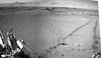
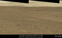
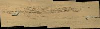
I'd say that the sol 634 drive put the Kimberley in the rear-view mirror, so it's time for a new thread! Let's see how fast they can move toward Murray Buttes now!
Attached thumbnail(s)
-------------------- My website - My Patreon - @elakdawalla on Twitter - Please support unmannedspaceflight.com by donating here.
|
|
 |
 
|
|
|
May 19 2014, 07:44 PM
Post
#2
|
||
 Junior Member Group: Members Posts: 73 Joined: 10-May 06 From: Spain Member No.: 770 |
To release the new thread.
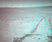
 Although there are still some images come, first version of the navcam right on Sol 634, leaving Kimberley.
|
|
|
|
|
|
|
May 19 2014, 08:56 PM
Post
#3
|
||
|
Member Group: Members Posts: 866 Joined: 15-March 05 From: Santa Cruz, CA Member No.: 196 |
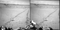
getting perspective on the egress to the wild open yonder again (crosseye)
|
|
|
|
|
|
|
May 19 2014, 10:38 PM
Post
#4
|
|
|
Member Group: Members Posts: 201 Joined: 16-December 13 Member No.: 7067 |
First half of the 634 drive into the crater:
http://i.imgur.com/0g2IPYw.gif Anaglyph: http://i.imgur.com/oBYTZdX.gif |
|
|
|
|
May 19 2014, 10:59 PM
Post
#5
|
||
|
Solar System Cartographer Group: Members Posts: 10167 Joined: 5-April 05 From: Canada Member No.: 227 |
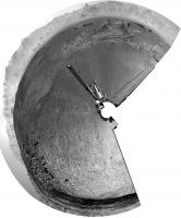
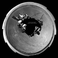
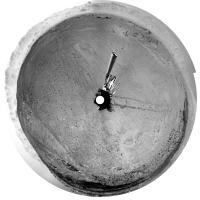
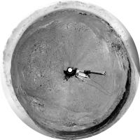
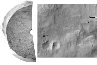
A circular version of Dig's partial panorama. Map update tomorrow (I'm home but this is a holiday in Canada)
EDIT - and we have a name! The rocky area SW of the rover is "Wesley Yard" (http://mars.jpl.nasa.gov/msl/images/MSL_Tr...ol0634-full.jpg) Thanks Fred! Much appreciated. PS: nice hat. Phil
-------------------- ... because the Solar System ain't gonna map itself.
Also to be found posting similar content on https://mastodon.social/@PhilStooke Maps for download (free PD: https://upload.wikimedia.org/wikipedia/comm...Cartography.pdf NOTE: everything created by me which I post on UMSF is considered to be in the public domain (NOT CC, public domain) |
|
|
|
|
|
|
May 20 2014, 12:50 AM
Post
#6
|
|||
|
Solar System Cartographer Group: Members Posts: 10167 Joined: 5-April 05 From: Canada Member No.: 227 |
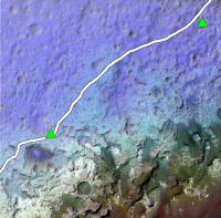
Here I have 'borrowed' jmknapp's nice topo map (posted in the route maps) and merged it with a CTX image. The red and orange hills at lower right are in the big dune field. This shows nicely that we have 1 km or so of driving across the depression we're in now, and then it will be uphill most of the time. The dunes are not in the lowest part of the crater, they are wrapped around the lower slopes of the hill.
Our current position is in the top right corner. Incidentally, we are about to move into the next map quadrangle, with a different source of names. We already crossed into it very briefly and then back into the Kimberley quad shortly before arriving at Kimberley. Phil
EDIT: version with the original route plan on it:
-------------------- ... because the Solar System ain't gonna map itself.
Also to be found posting similar content on https://mastodon.social/@PhilStooke Maps for download (free PD: https://upload.wikimedia.org/wikipedia/comm...Cartography.pdf NOTE: everything created by me which I post on UMSF is considered to be in the public domain (NOT CC, public domain) |
||
|
|
|
||
|
May 20 2014, 06:01 AM
Post
#7
|
||
|
Senior Member Group: Members Posts: 2835 Joined: 22-April 05 From: Ridderkerk, Netherlands Member No.: 353 |
Looking back on Sol 634 with the Navcam L camera.
Jan van Driel
|
|
|
|
|
|
|
May 20 2014, 09:57 AM
Post
#8
|
|
 Senior Member Group: Members Posts: 1619 Joined: 12-February 06 From: Bergerac - FR Member No.: 678 |
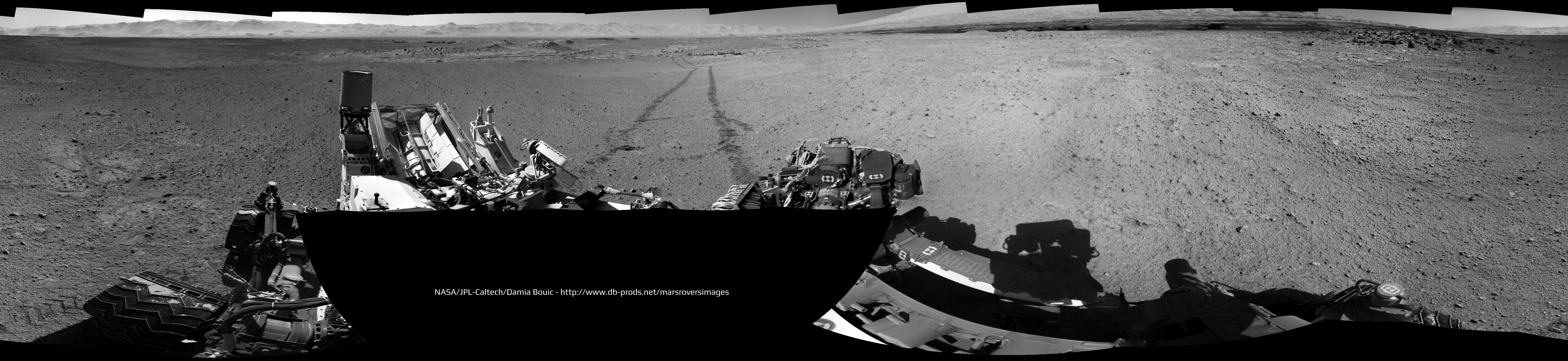
Sol 634 complete panoramic :
-------------------- |
|
|
|
|
May 20 2014, 10:47 AM
Post
#9
|
||
|
Junior Member Group: Members Posts: 73 Joined: 10-May 06 From: Spain Member No.: 770 |
Damia, you've passed by a few minutes.
 Well, my version. Navcam Right Sol 634 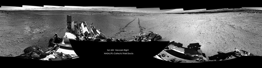 Click on image for full resolution And polar projection
|
|
|
|
|
|
|
May 20 2014, 11:01 AM
Post
#10
|
|
 Senior Member Group: Members Posts: 1465 Joined: 9-February 04 From: Columbus OH USA Member No.: 13 |
I figured out how to get a higher-res topo map out of MATLAB, 4800x3600: topo4800.png
The days of easy riding may be getting short. -------------------- |
|
|
|
|
May 20 2014, 02:01 PM
Post
#11
|
|
|
Member Group: Members Posts: 201 Joined: 16-December 13 Member No.: 7067 |
Completed Sol 634 drive, HTML5 link - Right click to show controls
Completed drive anaglyph Finished the 634 3D pan album http://imgur.com/a/pmZkq EDIT: created a stretched anaglyph album http://imgur.com/a/D7DG8#0 One extra mid-drive anaglyph http://i.imgur.com/29lPTbP.jpg |
|
|
|
|
May 20 2014, 04:23 PM
Post
#12
|
||
|
Solar System Cartographer Group: Members Posts: 10167 Joined: 5-April 05 From: Canada Member No.: 227 |
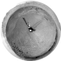
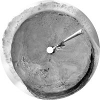
Finally getting back to normal. Here's a circular version of the full 634 pan borrowed from Damia:
Phil -------------------- ... because the Solar System ain't gonna map itself.
Also to be found posting similar content on https://mastodon.social/@PhilStooke Maps for download (free PD: https://upload.wikimedia.org/wikipedia/comm...Cartography.pdf NOTE: everything created by me which I post on UMSF is considered to be in the public domain (NOT CC, public domain) |
|
|
|
|
|
|
May 20 2014, 06:07 PM
Post
#13
|
||
|
Senior Member Group: Members Posts: 2835 Joined: 22-April 05 From: Ridderkerk, Netherlands Member No.: 353 |
The Navcam L view on Sol 634.
Jan van Driel
|
|
|
|
|
|
|
May 20 2014, 07:22 PM
Post
#14
|
|
|
Member Group: Members Posts: 201 Joined: 16-December 13 Member No.: 7067 |
Here is the Sol 635 anaglyph pan.
http://imgur.com/a/EUoVu#0 Here is the 635 drive http://i.imgur.com/gu1vOHX.gif Here is the drive anaglyph (minus one corrupted frame) http://i.imgur.com/S5HAGOe.gif And here is the last segment separated: feels nicer when it is continuous http://i.imgur.com/oRK5INy.gif |
|
|
|
|
May 21 2014, 06:28 AM
Post
#15
|
||
|
Senior Member Group: Members Posts: 2835 Joined: 22-April 05 From: Ridderkerk, Netherlands Member No.: 353 |
The Navcam L view on Sol 635.
Jan van Driel
|
|
|
|
|
|
|
May 21 2014, 12:19 PM
Post
#16
|
||
|
Senior Member Group: Members Posts: 1465 Joined: 9-February 04 From: Columbus OH USA Member No.: 13 |
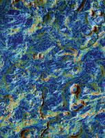
A little different view of the terrain, with the local slope color-coded:
dark blue: 0-5% light blue: 5-10% green: 10-15% orange: 15-20% red: >20% -------------------- |
|
|
|
|
|
|
May 21 2014, 02:33 PM
Post
#17
|
||
|
Solar System Cartographer Group: Members Posts: 10167 Joined: 5-April 05 From: Canada Member No.: 227 |
Here is Jan's panorama in circular form, showing a nice easy driving area. As jmknapp noted, it's going to get a lot more rugged pretty soon.
Phil
-------------------- ... because the Solar System ain't gonna map itself.
Also to be found posting similar content on https://mastodon.social/@PhilStooke Maps for download (free PD: https://upload.wikimedia.org/wikipedia/comm...Cartography.pdf NOTE: everything created by me which I post on UMSF is considered to be in the public domain (NOT CC, public domain) |
|
|
|
|
|
|
May 21 2014, 06:37 PM
Post
#18
|
|
|
Senior Member Group: Members Posts: 1074 Joined: 21-September 07 From: Québec, Canada Member No.: 3908 |
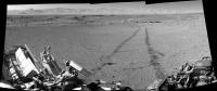
The large rock in the middle of this image seems a bit out of place. From this distance, its surface texture reminds me of the pits on a meteorite. Since we're moving more or less in that direction, maybe we'll get a better view later.
|
|
|
|
|
May 21 2014, 06:53 PM
Post
#19
|
|
|
Member Group: Members Posts: 201 Joined: 16-December 13 Member No.: 7067 |
Sol 636 images are coming down, here is the beginning of full pan, looking south and panning right
http://imgur.com/a/WQQox#0 Stretched version - far from perfect since I'm struggling to correct the tilt (straightforward with one image, less so with a pair), but it does bring out features I wouldn't have noticed. http://imgur.com/a/S2w8R#0 |
|
|
|
|
May 21 2014, 07:26 PM
Post
#20
|
|
|
Solar System Cartographer Group: Members Posts: 10167 Joined: 5-April 05 From: Canada Member No.: 227 |
That big rock does look enticing! I think we'll go pretty close to it.
Phil -------------------- ... because the Solar System ain't gonna map itself.
Also to be found posting similar content on https://mastodon.social/@PhilStooke Maps for download (free PD: https://upload.wikimedia.org/wikipedia/comm...Cartography.pdf NOTE: everything created by me which I post on UMSF is considered to be in the public domain (NOT CC, public domain) |
|
|
|
|
May 22 2014, 12:39 AM
Post
#21
|
|
|
Administrator Group: Admin Posts: 5172 Joined: 4-August 05 From: Pasadena, CA, USA, Earth Member No.: 454 |
Random note: a few weeks ago I learned that the DAN pulsing neutron generator had a limited lifetime. Today someone pointed out the arithmetic to me: the warranted lifetime for DAN was 3 years after launch, or until December 2013. So any day that DAN's active mode continues to work is a blessing. Similar units on Earth have lasted anywhere from 2 to 6 years, so it could continue to work for a while, but may not. It should function forever in passive mode, and still do great science searching for anomalous levels of hydrogen in the subsurface, but once the neutron generator dies (and apparently once it goes, it goes quickly) it will no longer be able to suss out the layered structure of the subsurface.
-------------------- My website - My Patreon - @elakdawalla on Twitter - Please support unmannedspaceflight.com by donating here.
|
|
|
|
|
May 22 2014, 04:08 PM
Post
#22
|
|
|
Member Group: Members Posts: 201 Joined: 16-December 13 Member No.: 7067 |
Finished the Sol 636 anaglyph pan albums with the new images at the beginning http://imgur.com/a/WQQox
And stretched http://imgur.com/a/S2w8R 12 drive images - first 6 are disjointed pairs, last 6 are continuous http://i.imgur.com/36Brv7K.gif So here are the anaglyph versions split into the 3 pairs and last bit (included all for the sake of completeness) 1st -2nd - 3rd Interesting part Sol 637 anaglyph album so far http://imgur.com/a/NBy3Z#0 And 637 stretched http://imgur.com/a/zPAc3#0 |
|
|
|
|
May 22 2014, 06:41 PM
Post
#23
|
||
|
Senior Member Group: Members Posts: 2835 Joined: 22-April 05 From: Ridderkerk, Netherlands Member No.: 353 |
Chemcam panorama taken on Sol 636.
Jan van Driel
|
|
|
|
|
|
|
May 22 2014, 07:27 PM
Post
#24
|
|
|
Solar System Cartographer Group: Members Posts: 10167 Joined: 5-April 05 From: Canada Member No.: 227 |
Another drive on sol 637, and it looks from the Hazcam as if we are just uphill from that big rock. Maybe a weekend target?
Phil -------------------- ... because the Solar System ain't gonna map itself.
Also to be found posting similar content on https://mastodon.social/@PhilStooke Maps for download (free PD: https://upload.wikimedia.org/wikipedia/comm...Cartography.pdf NOTE: everything created by me which I post on UMSF is considered to be in the public domain (NOT CC, public domain) |
|
|
|
|
May 22 2014, 07:27 PM
Post
#25
|
||
|
Senior Member Group: Members Posts: 2835 Joined: 22-April 05 From: Ridderkerk, Netherlands Member No.: 353 |
Navcam NL B view on Sol 636.
Jan van Driel
|
|
|
|
|
|
|
May 23 2014, 07:41 AM
Post
#26
|
||
|
Senior Member Group: Members Posts: 2835 Joined: 22-April 05 From: Ridderkerk, Netherlands Member No.: 353 |
The Mastcam L view on Sol 636.
Jan van Driel
|
|
|
|
|
|
|
May 23 2014, 08:36 AM
Post
#27
|
||
|
Senior Member Group: Members Posts: 2835 Joined: 22-April 05 From: Ridderkerk, Netherlands Member No.: 353 |
The Navcam L view on Sol 637.
Jan van Driel
|
|
|
|
|
|
|
May 23 2014, 10:48 AM
Post
#28
|
||
|
Senior Member Group: Members Posts: 1465 Joined: 9-February 04 From: Columbus OH USA Member No.: 13 |
Anaglyph looking south:
-------------------- |
|
|
|
|
|
|
May 23 2014, 02:58 PM
Post
#29
|
|
|
Member Group: Members Posts: 910 Joined: 4-September 06 From: Boston Member No.: 1102 |
Nice!! Joe, what do you estimate the size of that rock/meteorite? Fred, we need someone standing next to it!
-------------------- |
|
|
|
|
May 23 2014, 03:11 PM
Post
#30
|
||
|
Senior Member Group: Members Posts: 2835 Joined: 22-April 05 From: Ridderkerk, Netherlands Member No.: 353 |
Part of the Sol 637 Navcam panorama in Stereo.
Jan van Driel
|
|
|
|
|
|
|
May 23 2014, 06:01 PM
Post
#31
|
||
 Senior Member Group: Members Posts: 4247 Joined: 17-January 05 Member No.: 152 |
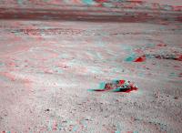
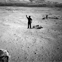
Here's a quick job, using Phil's map to estimate 11.6 and 35 metres to the two large rocks:
The closer rock, which does look kind of iron-meteoric, is about 50 cm tall (visibly) by 1.5 m long - I think that'd put it considerably larger than anything MER has encountered. |
|
|
|
|
|
|
May 23 2014, 06:06 PM
Post
#32
|
|
|
Senior Member Group: Members Posts: 1465 Joined: 9-February 04 From: Columbus OH USA Member No.: 13 |
Floyd: roughly I get that the rock is 14.5 meters away and covers an angle of about 8.1 degrees in the NAVCAM frame. That would make it about 2 meters across at the base.
EDIT: I got the distance estimate using 38 pixels of shift in position between NAVCAM L and R, baseline of .414m: d=(.414/2)/tan(45.33/1024*38/2) -- Fred's estimate using the map could be closer, who knows. -------------------- |
|
|
|
|
May 23 2014, 06:25 PM
Post
#33
|
||
|
Solar System Cartographer Group: Members Posts: 10167 Joined: 5-April 05 From: Canada Member No.: 227 |
At this stage my position is only accurate to within a few meters, I don't make any claims beyond that.
Here's a circular pan from jvandriel's postings.
Phil -------------------- ... because the Solar System ain't gonna map itself.
Also to be found posting similar content on https://mastodon.social/@PhilStooke Maps for download (free PD: https://upload.wikimedia.org/wikipedia/comm...Cartography.pdf NOTE: everything created by me which I post on UMSF is considered to be in the public domain (NOT CC, public domain) |
|
|
|
|
|
|
May 23 2014, 07:18 PM
Post
#34
|
|
|
Member Group: Members Posts: 910 Joined: 4-September 06 From: Boston Member No.: 1102 |
Thank you Fred and Joe! Like Phil, I certainly hope we head south for a scientific diversion to examine these rocks.
-------------------- |
|
|
|
|
May 23 2014, 10:13 PM
Post
#35
|
|
|
Senior Member Group: Members Posts: 1074 Joined: 21-September 07 From: Québec, Canada Member No.: 3908 |
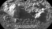
ChemCam had a look at the "big rock" (lower part of the image).
Looks more and more like a meteorite to me. |
|
|
|
|
May 23 2014, 10:27 PM
Post
#36
|
|
|
Junior Member Group: Members Posts: 94 Joined: 22-March 06 Member No.: 722 |
Looks like another iron, but I'm hoping it's a chondrite. It must weigh several tons, even on Mars.
-------------------- Mayor: Er, Master Betty, what is the Evil Council's plan?
Master Betty: Nyah. Haha. It is EVIL, it is so EVIL. It is a bad, bad plan, which will hurt many... people... who are good. I think it's great that it's so bad. -Kung Pow: Enter the Fist |
|
|
|
|
May 23 2014, 11:18 PM
Post
#37
|
|
 Senior Member Group: Members Posts: 2429 Joined: 30-January 13 From: Penang, Malaysia. Member No.: 6853 |
QUOTE (charborob @ May 24 2014, 06:13 AM)  ChemCam had a look at the "big rock" (lower part of the image)..... Those RMI's appear to be series (stack) of varying focus... Hopefully one of the image guru's can assemble these so we can study this in greater detail |
|
|
|
|
May 24 2014, 12:02 AM
Post
#38
|
|
|
Senior Member Group: Members Posts: 4247 Joined: 17-January 05 Member No.: 152 |
QUOTE (charborob @ May 23 2014, 11:13 PM) ChemCam had a look at the "big rock" (lower part of the image). That's the farther of the two rocks I put men beside in my post above. There was also chemcam imagery of the closer rock: http://mars.jpl.nasa.gov/msl-raw-images/pr...CCAM01637M_.JPG Both of these were taken pre-drive on 637, so they should match this navcam view: http://mars.jpl.nasa.gov/msl-raw-images/pr...NCAM00285M_.JPG |
|
|
|
|
May 24 2014, 05:41 AM
Post
#39
|
|
|
Senior Member Group: Members Posts: 4247 Joined: 17-January 05 Member No.: 152 |
QUOTE (jmknapp @ May 23 2014, 06:06 PM) Floyd: roughly I get that the rock is 14.5 meters away and covers an angle of about 8.1 degrees in the NAVCAM frame. That would make it about 2 meters across at the base. EDIT: I got the distance estimate using 38 pixels of shift in position between NAVCAM L and R, baseline of .414m: d=(.414/2)/tan(45.33/1024*38/2) -- Fred's estimate using the map could be closer, who knows. OK, I checked and got similar numbers using parallax: 13.8 +/- 0.5 metres, and 39.5 +/- 3 metres for the farther rock. I used a navcam separation of 42.4 cm from "The Mars Science Laboratory Engineering Cameras", Maki etal. If these numbers are correct, you should shrink the men by around 10-15% in my image. Either way these are big rocks. |
|
|
|
|
May 24 2014, 09:50 AM
Post
#40
|
|
 Member Group: Members Posts: 810 Joined: 3-June 04 From: Brittany, France Member No.: 79 |
Panorama taken on sol 637 with MastCam 34mm:

-------------------- |
|
|
|
|
May 24 2014, 11:01 AM
Post
#41
|
|
|
Senior Member Group: Members Posts: 1465 Joined: 9-February 04 From: Columbus OH USA Member No.: 13 |
QUOTE (fredk @ May 24 2014, 12:41 AM) Either way these are big rocks. That's the bottom line--without a reference appearances are often deceiving, but not in this case. BTW, my calculation above getting the parallax by counting pixels of offset between L and R doesn't take into account any possible toe-in or -out of the respective optical axes. -------------------- |
|
|
|
|
May 24 2014, 12:32 PM
Post
#42
|
|||
|
Member Group: Members Posts: 810 Joined: 3-June 04 From: Brittany, France Member No.: 79 |
Two animations showing Curiosity roving between sols 634 and 637. Higher resolution versions are available here and here.
Looking southwest west:
Looking northwest west:
-------------------- |
||
|
|
|
||
|
May 24 2014, 05:05 PM
Post
#43
|
|
|
Member Group: Members Posts: 201 Joined: 16-December 13 Member No.: 7067 |
Great multi-Sol comparisons! The large rock-less ground must be nice for drive planning, but I can't wait to get up next to some interesting things.
Sol 637 anaglyph album Stretched album - really emphasizes the slopes Drive animation  Sol 637 drive RNav - 6 frames looking right, the rest looking behind at the tracks Anaglyph of first segment looking right reverse-looped Anaglyph looking at the tracks during the drive |
|
|
|
|
May 24 2014, 08:02 PM
Post
#44
|
||
|
Senior Member Group: Members Posts: 2835 Joined: 22-April 05 From: Ridderkerk, Netherlands Member No.: 353 |
Here is the complete Sol 637 Navcam panoramic view.
Jan van Driel
|
|
|
|
|
|
|
May 24 2014, 10:44 PM
Post
#45
|
|
|
Senior Member Group: Members Posts: 4247 Joined: 17-January 05 Member No.: 152 |
QUOTE (jmknapp @ May 24 2014, 11:01 AM) my calculation above getting the parallax by counting pixels of offset between L and R doesn't take into account any possible toe-in or -out of the respective optical axes. I took that into accound, as well as 0.35 degrees of relative field rotation between L and R. (I just aligned the L and R frames until the distant slopes coincided.) But I didn't use the proper pixel scale - I just assumed 45 degrees/1024 pixels, when it actually varies quite a bit across the field. The reference I cited above gives a pixel scale of 0.82 mrad/pixel at the centre of the frame, which is where the near rock is. That gives a distance of 12.9 +/- 0.5 metres, which now is pretty much consistent with the estimate from Phil's map. |
|
|
|
|
May 25 2014, 09:14 AM
Post
#46
|
|
|
Member Group: Members Posts: 866 Joined: 15-March 05 From: Santa Cruz, CA Member No.: 196 |
|
|
|
|
|
May 25 2014, 06:51 PM
Post
#47
|
|
|
Member Group: Members Posts: 910 Joined: 4-September 06 From: Boston Member No.: 1102 |
I guess with the holiday weekend we won't move towards or get any images of the large rocks/meteorites until Wednesday. Hard to wait sometimes...
-------------------- |
|
|
|
|
May 26 2014, 10:34 AM
Post
#48
|
|
 Member Group: Members Posts: 691 Joined: 21-December 07 From: Clatskanie, Oregon Member No.: 3988 |
Definitely a metal object!

|
|
|
|
|
May 26 2014, 10:50 AM
Post
#49
|
|
|
Senior Member Group: Members Posts: 1465 Joined: 9-February 04 From: Columbus OH USA Member No.: 13 |
Is there a compelling scientific reason for MSL to analyze an iron-nickel meteor further (drive over there, etc)?
-------------------- |
|
|
|
|
May 26 2014, 11:01 AM
Post
#50
|
|
|
Senior Member Group: Members Posts: 2429 Joined: 30-January 13 From: Penang, Malaysia. Member No.: 6853 |
QUOTE (jmknapp @ May 26 2014, 06:50 PM) Is there a compelling scientific reason for MSL to analyze an iron-nickel meteor further (drive over there, etc)? According to 'Midnight Planets' Curiosity is driving now (awaiting metadata) we will have to see where she is going |
|
|
|
|
May 26 2014, 12:05 PM
Post
#51
|
||
|
Senior Member Group: Members Posts: 1074 Joined: 21-September 07 From: Québec, Canada Member No.: 3908 |
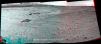
Sol 637 mastcam 100 view of the two "rocks":
If these are meteorites (as they appear to be), isn't it quite a coincidence that they are so close together? Unless they are part of a larger body that broke up either on its way down or upon impact. |
|
|
|
|
|
|
May 26 2014, 03:47 PM
Post
#52
|
|
|
Senior Member Group: Members Posts: 1465 Joined: 9-February 04 From: Columbus OH USA Member No.: 13 |
QUOTE (PaulH51 @ May 26 2014, 06:01 AM) According to 'Midnight Planets' Curiosity is driving now (awaiting metadata) we will have to see where she is going The SPICE position file was finally updated this morning after several days, but it just has a couple of of short bumps yesterday (sol 640), maybe spurious. I was just wondering given the overall aim of the effort (characterizing the "lacustrine" history of the crater, etc.), if an extraterrestrial rock is on point. -------------------- |
|
|
|
|
May 26 2014, 03:52 PM
Post
#53
|
|
 Senior Member Group: Moderator Posts: 3431 Joined: 11-August 04 From: USA Member No.: 98 |
The bumps aren't spurious (I don't think); typical wheel examination (see bottom of page).
Gorgeous (and probably practical in some way?) early morning lighting, too. |
|
|
|
|
May 26 2014, 03:57 PM
Post
#54
|
|
|
Solar System Cartographer Group: Members Posts: 10167 Joined: 5-April 05 From: Canada Member No.: 227 |
The short bumps are not spurious, they are doing wheel imaging with small rotations between images.
Checking whether these rocks are meteorites is a worthy goal - not enough for a long stop, but I would suggest it would be useful to get ChemCam LIBS data on them to compare with APXS which we have for the Meridiani meteorites. As for clustering, Spirit also say 2 or possibly 3 meteorites at Low Ridge Haven, and at Meridiani Shelter Island and Mackinac Island were also close together. Atmospheric breakup seems quite likely. Phil -------------------- ... because the Solar System ain't gonna map itself.
Also to be found posting similar content on https://mastodon.social/@PhilStooke Maps for download (free PD: https://upload.wikimedia.org/wikipedia/comm...Cartography.pdf NOTE: everything created by me which I post on UMSF is considered to be in the public domain (NOT CC, public domain) |
|
|
|
|
May 26 2014, 04:01 PM
Post
#55
|
|||
|
Solar System Cartographer Group: Members Posts: 10167 Joined: 5-April 05 From: Canada Member No.: 227 |
These are circular views from sols 636 and 637 showing recent drives and surrounding features.
Phil 636:
637:
-------------------- ... because the Solar System ain't gonna map itself.
Also to be found posting similar content on https://mastodon.social/@PhilStooke Maps for download (free PD: https://upload.wikimedia.org/wikipedia/comm...Cartography.pdf NOTE: everything created by me which I post on UMSF is considered to be in the public domain (NOT CC, public domain) |
||
|
|
|
||
|
May 26 2014, 10:35 PM
Post
#56
|
|
|
Senior Member Group: Members Posts: 1044 Joined: 17-February 09 Member No.: 4605 |
QUOTE (jmknapp @ May 26 2014, 10:50 AM) Is there a compelling scientific reason for MSL to analyze an iron-nickel meteor further (drive over there, etc)? Assuming that they are, as they seem, iron meteorites then the impact must have occurred when there was a reasonably thick atmosphere and an appreciable depth of material (sandstone / mud / water) above their present level since there is no trace of impact excavation and no appreciable fragmentation, although the original could perhaps have split in half, potentially just before impact. So a closer examination could give an important data point on the environment post impact. Besides, how could an entity named Curiosity fail to have a quick look? |
|
|
|
|
May 26 2014, 10:47 PM
Post
#57
|
|
|
Member Group: Members Posts: 201 Joined: 16-December 13 Member No.: 7067 |
Hopefully ChemCam got some good distance zaps in, because that rock (meteorite for sure?) is now far in the rear-view mirror!
 (just thumbnails for now) (just thumbnails for now)I've been surprised by how far west we've headed - I guess that way lies flatter ground for longer drives. And softer ground - because unlike Opportunity's solar arrays, the wheels aren't getting any better |
|
|
|
|
May 26 2014, 11:12 PM
Post
#58
|
|
|
Member Group: Members Posts: 140 Joined: 20-November 07 Member No.: 3967 |
QUOTE (serpens @ May 26 2014, 05:35 PM) . . . reasonably thick atmosphere . . . appreciable depth of material . . . no trace of impact excavation . . . no appreciable fragmentation, . . . closer examination could give an important data point . . . . Besides, how could an entity named Curiosity fail to have a quick look? Applause! (Is the obvious really obvious until someone states it precisely and clearly?) |
|
|
|
|
May 27 2014, 12:05 AM
Post
#59
|
|
|
Senior Member Group: Members Posts: 1465 Joined: 9-February 04 From: Columbus OH USA Member No.: 13 |
-------------------- |
|
|
|
|
May 27 2014, 12:06 AM
Post
#60
|
||
|
Solar System Cartographer Group: Members Posts: 10167 Joined: 5-April 05 From: Canada Member No.: 227 |
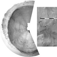
Very quick circular pan and sketch map - proper map update tomorrow.
Phil
-------------------- ... because the Solar System ain't gonna map itself.
Also to be found posting similar content on https://mastodon.social/@PhilStooke Maps for download (free PD: https://upload.wikimedia.org/wikipedia/comm...Cartography.pdf NOTE: everything created by me which I post on UMSF is considered to be in the public domain (NOT CC, public domain) |
|
|
|
|
|
|
May 27 2014, 03:05 AM
Post
#61
|
|
|
Member Group: Members Posts: 201 Joined: 16-December 13 Member No.: 7067 |
MAHLI sequence of the wheel exam:
The right rear wheels bump over some rocks Meanwhile the left rear wheel swallows a small rock whole - I can't tell where it goes! Reverse-looped anaglyph of the NavCams looking right And the Sol 641 anaglyph pan album with the 5 images so far http://imgur.com/a/7K9uE#0 http://imgur.com/a/z5vKn#0 - Stretched I'm guessing we're heading to the gap before the double craters to the WSW |
|
|
|
|
May 27 2014, 12:27 PM
Post
#62
|
|
|
Senior Member Group: Members Posts: 1465 Joined: 9-February 04 From: Columbus OH USA Member No.: 13 |
Found an interesting paper: The Scientific Rationale for Studying Meteorites found on Other Worlds
According to the paper: QUOTE Among the most valuable scientific applications of martian finds is as control or witness samples for probing both physical and chemical weathering environments [Ashley and Wright, 2004]. The hypersensitivity of most meteorites to mineral-volatile interactions makes them particularly well suited to the latter purpose. The chemical weathering of primary minerals constitute a suite of processes that can provide clues to climate behavior in the environment of their occurrence... Iron oxidation might be used as a kind of litmus test for the past availability of water on Mars... Meteorites on Mars have been estimated to decompose completely from chemical weathering on a one-Gyr timescale [Bland and Smith, 2000]. If we thus assume that many or most meteorites resting on the surface are likely to be more recent (Hesperian to Amazonian) additions to the planet, then their aqueous alteration would address the effects of more recent (and therefore more subtle) water availability.
-------------------- |
|
|
|
|
May 27 2014, 12:53 PM
Post
#63
|
|
|
Senior Member Group: Members Posts: 1074 Joined: 21-September 07 From: Québec, Canada Member No.: 3908 |
|
|
|
|
|
May 27 2014, 04:31 PM
Post
#64
|
|
|
Member Group: Members Posts: 810 Joined: 3-June 04 From: Brittany, France Member No.: 79 |
It has not been posted yet, so here is a mosaic of MC100 pictures showing Wesley Yard on sol 635:
Raw colors:  False colors: 
-------------------- |
|
|
|
|
May 27 2014, 04:55 PM
Post
#65
|
|
|
Member Group: Members Posts: 810 Joined: 3-June 04 From: Brittany, France Member No.: 79 |
An outcrop located southwest of Wesley Yard imaged with MC100 on sol 636:

-------------------- |
|
|
|
|
May 27 2014, 05:16 PM
Post
#66
|
|
|
Member Group: Members Posts: 810 Joined: 3-June 04 From: Brittany, France Member No.: 79 |
My take on the MC100 mosaic of the two meteorites on sol 637:
Raw colors:  False colors: 
-------------------- |
|
|
|
|
May 27 2014, 06:11 PM
Post
#67
|
|
|
Member Group: Members Posts: 122 Joined: 19-June 07 Member No.: 2455 |
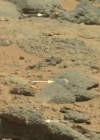
QUOTE (neo56 @ May 27 2014, 09:31 AM) It has not been posted yet, so here is a mosaic of MC100 pictures showing Wesley Yard on sol 635: Raw colors:  False colors: In both of your images to the right of center there are small bright white objects jutting out of the rocks that are seem very unusual in shape. One looks like a marble. Hard to tell at this magnification. Are these something worthwhile moving in for a close look? |
|
|
|
|
May 27 2014, 06:19 PM
Post
#68
|
|
|
Member Group: Members Posts: 810 Joined: 3-June 04 From: Brittany, France Member No.: 79 |
QUOTE (Art Martin @ May 27 2014, 06:11 PM) In both of your images to the right of center there are small bright white objects jutting out of the rocks that are seem very unusual in shape. One looks like a marble. Hard to tell at this magnification. Are these something worthwhile moving in for a close look? Indeed, I see what you mean. I'm not a geologist but on the basis of the rocks Curiosity analyzed so far, I would say it could be gypsum. Curiosity won't get closer to these rocks but will continue its journey to the base of Mount Sharp instead. -------------------- |
|
|
|
|
May 27 2014, 06:23 PM
Post
#69
|
||
|
Senior Member Group: Members Posts: 2835 Joined: 22-April 05 From: Ridderkerk, Netherlands Member No.: 353 |
The Navcam L view on Sol 641.
Jan van Driel
|
|
|
|
|
|
|
May 27 2014, 06:32 PM
Post
#70
|
||
 Member Group: Members Posts: 267 Joined: 5-February 06 Member No.: 675 |
Interesting inclusions.
What do the geologists think of them? |
|
|
|
|
|
|
May 28 2014, 01:57 AM
Post
#71
|
||
|
Senior Member Group: Members Posts: 1074 Joined: 21-September 07 From: Québec, Canada Member No.: 3908 |
Sol 641 mastcam 34 view ahead:
|
|
|
|
|
|
|
May 28 2014, 03:06 AM
Post
#72
|
|
 Senior Member Group: Members Posts: 3419 Joined: 9-February 04 From: Minneapolis, MN, USA Member No.: 15 |
QUOTE (serpens @ May 26 2014, 04:35 PM) ...there is no trace of impact excavation and no appreciable fragmentation... Aren't these characteristics of all of the iron meteorites we've seen on the surface? I can recall several examples at Meridiani. They all seem to be perched directly on top of the current surface, not even partially buried by lag deposits. They do all seem to show up on deflated surfaces, though, which is certainly consistent with your observations about the surface deflation at Gale. I have a gut feeling that there is more to the story, but as to the specifics of what that "more" is, there are no working theories that have come to mind yet... -the other Doug (with my shield, not yet upon it) -------------------- The trouble ain't that there is too many fools, but that the lightning ain't distributed right. -Mark Twain
|
|
|
|
|
May 28 2014, 07:49 AM
Post
#73
|
|
|
Member Group: Members Posts: 691 Joined: 21-December 07 From: Clatskanie, Oregon Member No.: 3988 |
I overlayed the single M100 color image that is down sofar onto my Chemcam RMI mosaic of the meteorite for some RMI Color.

|
|
|
|
|
May 28 2014, 08:49 AM
Post
#74
|
|
|
Senior Member Group: Members Posts: 1044 Joined: 17-February 09 Member No.: 4605 |
QUOTE (dvandorn @ May 28 2014, 04:06 AM) Aren't these characteristics of all of the iron meteorites we've seen on the surface? I can recall several examples at Meridiani. Given the current lack of atmosphere, iron meteorites spearing in today would almost certainly fragment/vaporise so almost all exposed meteorites would of necessity be ancient and excavated and on the surface. Opportunity did observe deposits of fragments and also passed (at a distance) what seemed to be decomposing piles which may have a meteoric provenance. Whether these were stone or stony iron remnants will always be unknown. |
|
|
|
|
May 28 2014, 10:08 AM
Post
#75
|
|
|
Senior Member Group: Members Posts: 1465 Joined: 9-February 04 From: Columbus OH USA Member No.: 13 |
QUOTE (serpens @ May 28 2014, 03:49 AM) almost all exposed meteorites would of necessity be ancient and excavated and on the surface How ancient? The working model reported is that this environment was a shallow lake at one time, albeit maybe more than a billion years back when Mars was warmer and wetter as the expression goes. Considering the inference that the atmosphere was dense when it arrived, if an iron meteor was exposed to that environment, would we expect it to be "rusty"? -------------------- |
|
|
|
|
May 28 2014, 10:26 AM
Post
#76
|
|
|
Member Group: Members Posts: 810 Joined: 3-June 04 From: Brittany, France Member No.: 79 |
Very nice picture James! Here is my take on the panorama taken with MC34 on sol 641:

-------------------- |
|
|
|
|
May 28 2014, 12:02 PM
Post
#77
|
|
|
Solar System Cartographer Group: Members Posts: 10167 Joined: 5-April 05 From: Canada Member No.: 227 |
" would we expect it to be "rusty"? " - no, we would more likely expect it to be sandblasted clean of rust.
Phil -------------------- ... because the Solar System ain't gonna map itself.
Also to be found posting similar content on https://mastodon.social/@PhilStooke Maps for download (free PD: https://upload.wikimedia.org/wikipedia/comm...Cartography.pdf NOTE: everything created by me which I post on UMSF is considered to be in the public domain (NOT CC, public domain) |
|
|
|
|
May 28 2014, 12:22 PM
Post
#78
|
|
|
Senior Member Group: Members Posts: 2429 Joined: 30-January 13 From: Penang, Malaysia. Member No.: 6853 |
QUOTE (Phil Stooke @ May 28 2014, 08:02 PM) " would we expect it to be "rusty"? " - no, we would more likely expect it to be sandblasted clean of rust. Phil If the nickel content of the alloy was high enough (FeNi or NiFe?), would we not also expect to see a strong resistance to corrosion? With the apparent absence of LIBS analysis of the targets, will the multi-spectral imaging of the meteorites we observed in the images on sol 641 provide any hints to the amount of nickel present? Or is that just me clutching at straws? Paul |
|
|
|
|
May 28 2014, 12:41 PM
Post
#79
|
||
|
Senior Member Group: Members Posts: 1465 Joined: 9-February 04 From: Columbus OH USA Member No.: 13 |
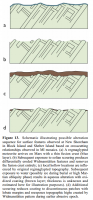
QUOTE (Phil Stooke @ May 28 2014, 07:02 AM) sandblasted clean of rust. But all of it? Evidence for mechanical and chemical alteration of iron‐nickel meteorites on Mars: Process insights for Meridiani Planum has this diagram:
Will have to try to use regmaglypt in a sentence... -------------------- |
|
|
|
|
|
|
May 28 2014, 03:23 PM
Post
#80
|
||
|
Senior Member Group: Members Posts: 2835 Joined: 22-April 05 From: Ridderkerk, Netherlands Member No.: 353 |
The 360 degree Navcam L panoramic view on Sol 641.
Jan van Driel
|
|
|
|
|
|
|
May 28 2014, 03:45 PM
Post
#81
|
|
|
Founder Group: Chairman Posts: 14432 Joined: 8-February 04 Member No.: 1 |
QUOTE (jmknapp @ May 28 2014, 04:41 AM) But all of it? Nope. If you look closely at this one (and the many seen by Spirit and Opportunity over the years) there are little patches tucked away inside some of the regmaglypts that could be signs of chemical erosion. It would also be quite hard to tell apart surficial dust ( being as it's largely iron oxides ) and rust on a iron meteorite ( being as it is also largely iron oxides ) |
|
|
|
|
May 28 2014, 03:47 PM
Post
#82
|
|
|
Member Group: Members Posts: 201 Joined: 16-December 13 Member No.: 7067 |
Completed Sol 641 anaglyph album - http://imgur.com/a/7K9uE
And the stretched album - http://imgur.com/a/z5vKn Full drive away from the meteorites Anaglyph versions of the two drive segments, first one has a nice perspective of both meteorites http://i.imgur.com/KVFy7YJ.gif -18 frames http://i.imgur.com/m1teQsb.gif -26 frames |
|
|
|
|
May 28 2014, 07:57 PM
Post
#83
|
|
|
Solar System Cartographer Group: Members Posts: 10167 Joined: 5-April 05 From: Canada Member No.: 227 |
And we get a name from Fred Calef's latest map at JPL - Lebanon is the closer meterorite.
And I think this is the first name from a new map quadrangle. Phil -------------------- ... because the Solar System ain't gonna map itself.
Also to be found posting similar content on https://mastodon.social/@PhilStooke Maps for download (free PD: https://upload.wikimedia.org/wikipedia/comm...Cartography.pdf NOTE: everything created by me which I post on UMSF is considered to be in the public domain (NOT CC, public domain) |
|
|
|
|
May 28 2014, 08:47 PM
Post
#84
|
|
|
Administrator Group: Admin Posts: 5172 Joined: 4-August 05 From: Pasadena, CA, USA, Earth Member No.: 454 |
Indeed, Fred said on Twitter we went into a new quad "on sol 636. The quad name is 'Hanover' after the New Hampshire city. The mapper of that quad went to Dartmouth."
-------------------- My website - My Patreon - @elakdawalla on Twitter - Please support unmannedspaceflight.com by donating here.
|
|
|
|
|
May 28 2014, 09:39 PM
Post
#85
|
|
|
Senior Member Group: Members Posts: 3516 Joined: 4-November 05 From: North Wales Member No.: 542 |
Quads: I've dug down and found out about the demarcation of the quads, the reason for their strange non-metric dimensions, the names of ones passed through and so forth - but it wasn't easy. I think a lot of followers here would appreciate a refresher on that topic if anyone's up for it.
|
|
|
|
|
May 28 2014, 10:03 PM
Post
#86
|
|
|
Administrator Group: Admin Posts: 5172 Joined: 4-August 05 From: Pasadena, CA, USA, Earth Member No.: 454 |
I've been asking for a map with the quad names on it for a long time but have not been able to get one. (If it is, in fact, on the Internet somewhere and I don't know about it -- I hope someone will point it out to me). The best explainer on the quad mapping thing is Calef et al. 2013 LPSC abstract (PDF).
-------------------- My website - My Patreon - @elakdawalla on Twitter - Please support unmannedspaceflight.com by donating here.
|
|
|
|
|
May 28 2014, 11:02 PM
Post
#87
|
|
|
Senior Member Group: Members Posts: 1044 Joined: 17-February 09 Member No.: 4605 |
I feel that it would be a mistake to use the "Block Island Trio" for want of a better description as a template. The weathering of these examples at Gale seems more akin to Heat Shield Rock. The remnant coating on the Meridiani Trio could simply indicate that the abrasive scouring was reduced dramatically to an extremely gentle caressing before the process of removing the coating was completed. I think we can be certain that the Meridiani examples were subject to a very acidic environment although if the impact occurred early enough they could have encountered higher pH, basalt buffered groundwater. For Gale however it seems that the environment at this level was consistently pretty much neutral and could well have been reducing. As far as time lines go we do not really have a clue whether the Gale examples impacted early on as the sediment in the crater was building up in a saturated environment or later during the dry, deflationary period. All is conjecture anyway as these rocks diminish in the rear view mirror.
|
|
|
|
|
May 28 2014, 11:15 PM
Post
#88
|
|
|
Administrator Group: Admin Posts: 5172 Joined: 4-August 05 From: Pasadena, CA, USA, Earth Member No.: 454 |
OK guys, when was the last time Curiosity used AutoNav? Was it before they started worrying about wheel wear?? Hazcams interspersed with Navcams on sol 643 suggest the rover was driving for itself...
-------------------- My website - My Patreon - @elakdawalla on Twitter - Please support unmannedspaceflight.com by donating here.
|
|
|
|
|
May 29 2014, 12:22 AM
Post
#89
|
||
|
Solar System Cartographer Group: Members Posts: 10167 Joined: 5-April 05 From: Canada Member No.: 227 |
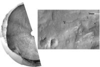
This is a quick guess at the new location. If it's right we are probably over the 7 km drive mark now.
Phil
-------------------- ... because the Solar System ain't gonna map itself.
Also to be found posting similar content on https://mastodon.social/@PhilStooke Maps for download (free PD: https://upload.wikimedia.org/wikipedia/comm...Cartography.pdf NOTE: everything created by me which I post on UMSF is considered to be in the public domain (NOT CC, public domain) |
|
|
|
|
|
|
May 29 2014, 01:10 AM
Post
#90
|
|
|
Senior Member Group: Members Posts: 1465 Joined: 9-February 04 From: Columbus OH USA Member No.: 13 |
That's pretty much the spot--85 meters: Drive 186
-------------------- |
|
|
|
|
May 29 2014, 08:55 AM
Post
#91
|
|
|
Senior Member Group: Members Posts: 1465 Joined: 9-February 04 From: Columbus OH USA Member No.: 13 |
Emily: I think the last time hazcams were mixed with navcams like that was on April 20, sol 606. They were looking at the wheels a lot during that drive. Before that, March 18, sol 574.
-------------------- |
|
|
|
|
May 29 2014, 03:05 PM
Post
#92
|
|
|
Member Group: Members Posts: 810 Joined: 3-June 04 From: Brittany, France Member No.: 79 |
Lebanon meteorite pictured with MC100 on sol 640:
Raw colors:  False colors:  And a context picture with MC34: 
-------------------- |
|
|
|
|
May 29 2014, 07:53 PM
Post
#93
|
||
|
Senior Member Group: Members Posts: 2835 Joined: 22-April 05 From: Ridderkerk, Netherlands Member No.: 353 |
Part of the Sol 643 Navcam L view.
Jan van Driel
|
|
|
|
|
|
|
May 29 2014, 07:59 PM
Post
#94
|
|
|
Member Group: Members Posts: 105 Joined: 27-August 05 Member No.: 479 |
It sure does look like metallic class |
|
|
|
|
May 29 2014, 11:02 PM
Post
#95
|
|
|
Senior Member Group: Members Posts: 1044 Joined: 17-February 09 Member No.: 4605 |
Is it my imagination or are the erosional patterns and structure of the two apparent meteorites in Neo56's context image sufficiently different as to raise the small possibility that these are the products of separate impacts? Be one heck of a coincidence of course.
|
|
|
|
|
May 30 2014, 02:11 AM
Post
#96
|
||
|
Solar System Cartographer Group: Members Posts: 10167 Joined: 5-April 05 From: Canada Member No.: 227 |
A good drive today, already past the two small craters. A proper map update tomorrow (I'm in restricted sols)
Phil
-------------------- ... because the Solar System ain't gonna map itself.
Also to be found posting similar content on https://mastodon.social/@PhilStooke Maps for download (free PD: https://upload.wikimedia.org/wikipedia/comm...Cartography.pdf NOTE: everything created by me which I post on UMSF is considered to be in the public domain (NOT CC, public domain) |
|
|
|
|
|
|
May 30 2014, 12:47 PM
Post
#97
|
||
|
Senior Member Group: Members Posts: 1074 Joined: 21-September 07 From: Québec, Canada Member No.: 3908 |
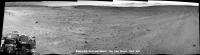
Sol 644: anaglyph of the two small craters:
|
|
|
|
|
|
|
May 30 2014, 02:19 PM
Post
#98
|
|
|
Member Group: Members Posts: 201 Joined: 16-December 13 Member No.: 7067 |
Very nice stitched view of the craters!
Here are the anaglyph albums for Sol 643 - Normal - Stretched But the views on 644 are much more impressive http://imgur.com/a/guNK8#0 Stretched: http://imgur.com/a/T0I0N#0 |
|
|
|
|
May 30 2014, 02:39 PM
Post
#99
|
||
|
Senior Member Group: Members Posts: 4247 Joined: 17-January 05 Member No.: 152 |
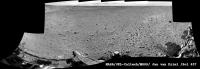
Lovely view out the rear view window:
|
|
|
|
|
|
|
May 30 2014, 06:45 PM
Post
#100
|
|
|
Junior Member Group: Members Posts: 73 Joined: 10-May 06 From: Spain Member No.: 770 |
Navcam Right Sol 644

|
|
|
|
|

|
Lo-Fi Version | Time is now: 26th May 2024 - 03:51 AM |
|
RULES AND GUIDELINES Please read the Forum Rules and Guidelines before posting. IMAGE COPYRIGHT |
OPINIONS AND MODERATION Opinions expressed on UnmannedSpaceflight.com are those of the individual posters and do not necessarily reflect the opinions of UnmannedSpaceflight.com or The Planetary Society. The all-volunteer UnmannedSpaceflight.com moderation team is wholly independent of The Planetary Society. The Planetary Society has no influence over decisions made by the UnmannedSpaceflight.com moderators. |
SUPPORT THE FORUM Unmannedspaceflight.com is funded by the Planetary Society. Please consider supporting our work and many other projects by donating to the Society or becoming a member. |
|