MSL Post Landing - Commissioning Period & Early Observations, Commissioning Activity Period 1B - Sols 9 through 16 |

  |
MSL Post Landing - Commissioning Period & Early Observations, Commissioning Activity Period 1B - Sols 9 through 16 |
 Aug 14 2012, 06:24 PM Aug 14 2012, 06:24 PM
Post
#1
|
|
 Administrator  Group: Admin Posts: 5172 Joined: 4-August 05 From: Pasadena, CA, USA, Earth Member No.: 454 |
Now that Curiosity has her driving and science software installed and is ready to proceed, I figured it was time for a new thread. Please keep sol 0-8 discussion in the previous thread (including discussion of the full-frame MARDIs, as they come down), and post new stuff here.
Things to look forward to: a Mastcam pan of the top of the mountain to be uplinked in the next sol or two; testing of the steering actuators on sol 13; first drive on sol 15. This period, which Grotzinger told me would take "no fewer than 6 sols," will be followed by an "Intermission," during which the science team may choose to drive to a new site (not very far away) for Commissioning Activity Period 2, when they'll commission the arm and its instruments. Also, an admin note: we allowed a lot of chit-chat in the landing thread because we were all so excited about the successful landing  But as we move forward, I'd like to ask people to be mindful of forum rule 2.2. The strength of this forum is in its high signal-to-noise ratio; avoid posting things that just say "wow, awesome" or "I agree." Please keep chit-chat to the chit-chat forum. But as we move forward, I'd like to ask people to be mindful of forum rule 2.2. The strength of this forum is in its high signal-to-noise ratio; avoid posting things that just say "wow, awesome" or "I agree." Please keep chit-chat to the chit-chat forum.
-------------------- My website - My Patreon - @elakdawalla on Twitter - Please support unmannedspaceflight.com by donating here.
|
 |
 
|
|
Aug 14 2012, 06:56 PM
Post
#2
|
|
|
Member Group: Members Posts: 282 Joined: 18-June 04 Member No.: 84 |
Will that Mountain Pan be with Mastcam 34 or 100 or both?
|
|
|
|
|
Aug 14 2012, 07:25 PM
Post
#3
|
|
 Newbie Group: Members Posts: 8 Joined: 21-April 12 Member No.: 6382 |
Do we know the extent of the pan? A narrow field of view capturing the peak and nearby foot hills, or a full sweep capturing edge to edge?
-------------------- |
|
|
|
|
Aug 14 2012, 07:26 PM
Post
#4
|
|
|
Member Group: Members Posts: 154 Joined: 21-April 05 From: Rochester, New York, USA Member No.: 336 |
As we look forward what will the bottlenecks to reaching the primary science target be? It seems there are a few:
- available power - ability to get data back from the rover (limited number of overflights), one set of commands per day - limited ability to operate autonomously - "distractions" from other science targets - wheel speed Any others? Which one is the biggest limitation? |
|
|
|
|
Aug 14 2012, 07:31 PM
Post
#5
|
|
|
Member Group: Admin Posts: 976 Joined: 29-September 06 From: Pasadena, CA - USA Member No.: 1200 |
Anomalies. From my initial analysis it seems that the area is pretty benign both in terms of slopes and in terms of obstacles, therefore we will be able to drive "blind" most of the time and use autonav to extend the drives beyond what we can see. We don't have a good sense on how far we can drive per Sol yet.
Paolo -------------------- Disclaimer: all opinions, ideas and information included here are my own,and should not be intended to represent opinion or policy of my employer.
|
|
|
|
|
Aug 16 2012, 01:09 PM
Post
#6
|
|
 Senior Member Group: Members Posts: 1465 Joined: 9-February 04 From: Columbus OH USA Member No.: 13 |
Wow, some images just came in from ChemCam and NAVCAM that were taken just 4 hours ago on sol 10 (that's to-sol). Curiosity and its relays firing on all cylinders.
-------------------- |
|
|
|
|
Aug 16 2012, 04:25 PM
Post
#7
|
|
|
Junior Member Group: Members Posts: 29 Joined: 12-February 04 Member No.: 29 |
QUOTE (jmknapp @ Aug 16 2012, 08:09 AM)  Wow, some images just came in from ChemCam and NAVCAM that were taken just 4 hours ago on sol 10 (that's to-sol). Curiosity and its relays firing on all cylinders. How do you get to the Sol 10 page from this basic link - it doesn't indicate any images beyond Sol 3? http://mars.jpl.nasa.gov/msl/multimedia/raw/ |
|
|
|
|
Aug 16 2012, 04:31 PM
Post
#8
|
|
|
Member Group: Members Posts: 154 Joined: 21-April 05 From: Rochester, New York, USA Member No.: 336 |
There is a link where you can view images by sol vs. by camera in the upper RH corner.
|
|
|
|
|
Aug 16 2012, 04:58 PM
Post
#9
|
|
|
Newbie Group: Members Posts: 8 Joined: 21-April 12 Member No.: 6382 |
What are we looking at with the new ChemCam-RMI images? There seems to be circles passing before it? These some sort of filters or similar tech that it will end up using, or taken with the cap on?
-------------------- |
|
|
|
|
Aug 16 2012, 05:08 PM
Post
#10
|
|
|
Senior Member Group: Members Posts: 1465 Joined: 9-February 04 From: Columbus OH USA Member No.: 13 |
A boatload of images coming in right now--some beautiful mastcam shots from sol 3 (sure is a hazy place though) and about 90 MARDI shots of the ground under Curiosity right around the time of the landing.
Here's a link to my browser app right now, but bear in mind the list scrolls down as new images come in: curiositymsl.com -------------------- |
|
|
|
|
Aug 16 2012, 05:56 PM
Post
#11
|
|
|
Founder Group: Chairman Posts: 14432 Joined: 8-February 04 Member No.: 1 |
QUOTE (Errol Coder @ Aug 16 2012, 09:58 AM) What are we looking at with the new ChemCam-RMI images? Its calibration target. http://www.msl-chemcam.com/index.php?menu=...sup&art=207 |
|
|
|
|
Aug 16 2012, 06:35 PM
Post
#12
|
|
|
Administrator Group: Admin Posts: 5172 Joined: 4-August 05 From: Pasadena, CA, USA, Earth Member No.: 454 |
The Navcam images taken at the same time provide context. The Chemcam is located above the left Navcam, so look at the center of the left Navcam images and you'll see the Chemcam cal target.
-------------------- My website - My Patreon - @elakdawalla on Twitter - Please support unmannedspaceflight.com by donating here.
|
|
|
|
|
Aug 17 2012, 12:12 AM
Post
#13
|
||
 Senior Member Group: Admin Posts: 3108 Joined: 21-December 05 From: Canberra, Australia Member No.: 615 |
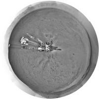
I know that this is obscure in terms of imagery, but here's the ChemCam Sol10 calibration target images (inset with flight spare).

|
|
|
|
|
|
|
Aug 17 2012, 04:05 PM
Post
#14
|
|
|
Member Group: Members Posts: 252 Joined: 5-May 05 From: Mississippi (USA) Member No.: 379 |
About an hour and a half to today's (Friday) Curiosity Rover Teleconference
I hope this information is correct. I am posting early just in case someone wants to correct me! NASA To Host Curiosity Rover Teleconference Aug. 17 10:30 a.m. PDT (1:30 p.m. EDT, 1730 UTC), Friday, Aug. 17 Apparently it will NOT be on NASATV - it WILL be streamed on the Curiosity Cam Ustream channel http://www.ustream.tv/nasajpl Mission controllers at NASA's Jet Propulsion Laboratory in Pasadena, Calif., are checking out Curiosity's subsystems and 10 instruments. Curiosity is in the opening days of a two-year mission to investigate whether conditions have been favorable for microbial life and preserving clues in the rocks about possible past life. Mission team members are "living" on Mars time. A Martian day is approximately 40 minutes longer than an Earth day, meaning team members start their shift 40 minutes later each day. The scheduling of this teleconference and other Curiosity media events is determined by their availability. Visuals will be available at the start of the teleconference at: http://go.nasa.gov/curiositytelecon. |
|
|
|
|
Aug 17 2012, 04:56 PM
Post
#15
|
|
|
Founder Group: Chairman Posts: 14432 Joined: 8-February 04 Member No.: 1 |
The audio itself will be right here ; http://www.nasa.gov/news/media/newsaudio/index.html
|
|
|
|
|
Aug 17 2012, 05:31 PM
Post
#16
|
|
|
Senior Member Group: Members Posts: 2087 Joined: 13-February 10 From: Ontario Member No.: 5221 |
Visuals are up. Very interesting...
EDIT: started.... |
|
|
|
|
Aug 17 2012, 05:32 PM
Post
#17
|
|
|
Member Group: Members Posts: 293 Joined: 29-August 06 From: Columbia, MD Member No.: 1083 |
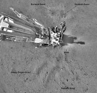
Based on the imagery, looks like "Glenelg", where the 3 terrain units meet just east of Curiosity will be the first target.
|
|
|
|
|
Aug 17 2012, 05:37 PM
Post
#18
|
|
 Senior Member Group: Members Posts: 4247 Joined: 17-January 05 Member No.: 152 |
Also based on this caption.
|
|
|
|
|
Aug 17 2012, 05:56 PM
Post
#19
|
|
|
Member Group: Members Posts: 293 Joined: 29-August 06 From: Columbia, MD Member No.: 1083 |
John Grotzinger: "~1-1.5 months to get to Glenelg, ~1 month of science at Glenelg, ~end-of-the-year start drive to base of Mt. Sharp".
|
|
|
|
|
Aug 17 2012, 05:59 PM
Post
#20
|
|
 Member Group: Members Posts: 710 Joined: 28-September 04 Member No.: 99 |
1.5 months for a 500m drive? Isn't that a bit slow compared to MER?
|
|
|
|
|
Aug 17 2012, 06:02 PM
Post
#21
|
|
|
Member Group: Members Posts: 282 Joined: 18-June 04 Member No.: 84 |
QUOTE (OWW @ Aug 17 2012, 06:59 PM) 1.5 months for a 500m drive? Isn't that a bit slow compared to MER? I thought I heard upto 2 months? I guess that includes possible science stops. |
|
|
|
|
Aug 17 2012, 06:04 PM
Post
#22
|
|
|
Senior Member Group: Members Posts: 2087 Joined: 13-February 10 From: Ontario Member No.: 5221 |
Yeah, Oppy at its best did that in a day or three. Of course the terrain there was even better, and they knew there were no science targets at all.
|
|
|
|
|
Aug 17 2012, 06:07 PM
Post
#23
|
|
|
Member Group: Members Posts: 293 Joined: 29-August 06 From: Columbia, MD Member No.: 1083 |
Neither MER was traveling 100m/sol for a long time after landing (not even during the primary mission IIRC). They're talking ~10m/sol, which will probably be (IMO) an average of some sols of stationary observations/science alternating with some sols of moderate, 10s of meters, driving.
|
|
|
|
|
Aug 17 2012, 06:07 PM
Post
#24
|
|
 Senior Member Group: Members Posts: 1729 Joined: 3-August 06 From: 43° 35' 53" N 1° 26' 35" E Member No.: 1004 |
I have lost a few sentences. do they plan to do anything at Goulburn Scour?
|
|
|
|
|
Aug 17 2012, 06:10 PM
Post
#25
|
|
|
Member Group: Members Posts: 293 Joined: 29-August 06 From: Columbia, MD Member No.: 1083 |
QUOTE (Paolo @ Aug 17 2012, 01:07 PM) do they plan to do anything at Goulburn Scour? Imaging with all cameras and laser-blasting with Chemcam. That's probably it. They're worried about the drill being damaged on those rocks. |
|
|
|
|
Aug 17 2012, 06:31 PM
Post
#26
|
|
|
Junior Member Group: Members Posts: 26 Joined: 7-August 12 Member No.: 6485 |
Interesting that they will only be drilling after their first big review. The drill's their crown jewel and it looks like they're being really careful with it.
|
|
|
|
|
Aug 17 2012, 06:40 PM
Post
#27
|
|
|
Junior Member Group: Members Posts: 59 Joined: 12-March 10 From: Austin, TX Member No.: 5262 |
ChemCam is so cool. Roger implied they hoped to find out something about the composition of the "dessert varnish" that covers rocks on Mars (and Earth). I've wondered if Earth varnish has anything to do with bacteria. The 276K temperature recorded suggests a similar possibility on Mars may be possible (though, of course, highly unlikely.)
|
|
|
|
|
Aug 17 2012, 07:35 PM
Post
#28
|
|
|
Junior Member Group: Members Posts: 26 Joined: 7-August 12 Member No.: 6485 |
Can the ChemCam wear out? I'm not sure if this is a silly question, but one of the replies in the Telecon seemed fairly specific in terms of the maximum number of pulses that they'd be using in the coming weeks. I looked through Wiens et al. and couldn't find any specific indication, but was interested to see that they were only allowed to fire 4500 pulses during the depth profile tests.
|
|
|
|
|
Aug 17 2012, 07:46 PM
Post
#29
|
|
|
Senior Member Group: Members Posts: 2517 Joined: 13-September 05 Member No.: 497 |
QUOTE (charleski @ Aug 17 2012, 12:35 PM) Can the ChemCam wear out? From http://www.lpi.usra.edu/meetings/lpsc2008/pdf/1500.pdf -- "However, the instrument was limited to 30 analyses per sol, realistic for its expected laser lifetime of ~20,000 analyses." I'm not sure this applies to the flight unit but I would expect the laser to have some finite lifetime. -------------------- Disclaimer: This post is based on public information only. Any opinions are my own.
|
|
|
|
|
Aug 17 2012, 07:47 PM
Post
#30
|
|
|
Senior Member Group: Members Posts: 2087 Joined: 13-February 10 From: Ontario Member No.: 5221 |
I'm wondering about the drill's longevity myself. I know Spirit's wore out a lot faster than Oppy's because of the difference in rock hardness, and so had to limit themselves to very interesting targets.
Will we have to wait until a drilling is done to see how much wear and tear it can take? |
|
|
|
|
Aug 17 2012, 07:50 PM
Post
#31
|
|
|
Senior Member Group: Members Posts: 2922 Joined: 14-February 06 From: Very close to the Pyrénées Mountains (France) Member No.: 682 |
QUOTE (Explorer1 @ Aug 17 2012, 09:47 PM) I'm wondering about the drill's longevity myself. I know Spirit's wore out a lot faster than Oppy's because of the difference in rock hardness, and so had to limit themselves to very interesting targets. Will we have to wait until a drilling is done to see how much wear and tear it can take? Listen to Emily here: http://www.planetary.org/blogs/emily-lakda...-curiosity.html They've got 2 more spare once the first one will be out  Edited: or read here: http://www.planetary.org/blogs/guest-blogs...rs-1-tools.html -------------------- |
|
|
|
|
Aug 17 2012, 08:05 PM
Post
#32
|
|
|
Junior Member Group: Members Posts: 59 Joined: 12-March 10 From: Austin, TX Member No.: 5262 |
QUOTE (charleski @ Aug 17 2012, 02:35 PM) Can the ChemCam wear out? I'm not sure if this is a silly question, but one of the replies in the Telecon seemed fairly specific in terms of the maximum number of pulses that they'd be using in the coming weeks. I heard this as referring to the design criteria, i.e., the minimum it should be able to do. |
|
|
|
|
Aug 17 2012, 08:06 PM
Post
#33
|
|
|
Member Group: Members Posts: 470 Joined: 24-March 04 From: Finland Member No.: 63 |
I got the impression that they were not so much afraid of the drill getting damaged, but that the rock at the rocket impigment site wouldn't be good to drill into. It has been suggested that it may be duricrust. Would that be too fragile to get a good sample out of with the drill?
Also I think it was mentioned that the first sample to go into the labrotary kits would be dust or some other fines that is scoopable. -------------------- Antti Kuosmanen
|
|
|
|
|
Aug 17 2012, 08:18 PM
Post
#34
|
|
|
Administrator Group: Admin Posts: 5172 Joined: 4-August 05 From: Pasadena, CA, USA, Earth Member No.: 454 |
I think it's just not a good first sample to drill. They're going to want something that has a horizontal surface and that is a piece of rock that looks homogeneous, not a conglomerate of chunks of rock that may be more or less strongly cemented together by something else.
-------------------- My website - My Patreon - @elakdawalla on Twitter - Please support unmannedspaceflight.com by donating here.
|
|
|
|
|
Aug 17 2012, 08:42 PM
Post
#35
|
|
|
Member Group: Members Posts: 154 Joined: 21-April 05 From: Rochester, New York, USA Member No.: 336 |
Also sounded like we will be waiting a while before the photos of the top of Mt. Sharp will be takend and transmitted. Originally, I believe it was hoped to get them in during the past few days. (If my memory is correct?)
|
|
|
|
|
Aug 17 2012, 09:39 PM
Post
#36
|
|||
|
Solar System Cartographer Group: Members Posts: 10173 Joined: 5-April 05 From: Canada Member No.: 227 |
Here's a circular version of the full navcam pan:
And this is the middle bit with labels to put our newest names into a more maplike perspective:
Phil -------------------- ... because the Solar System ain't gonna map itself.
Also to be found posting similar content on https://mastodon.social/@PhilStooke Maps for download (free PD: https://upload.wikimedia.org/wikipedia/comm...Cartography.pdf NOTE: everything created by me which I post on UMSF is considered to be in the public domain (NOT CC, public domain) |
||
|
|
|
||
|
Aug 17 2012, 09:43 PM
Post
#37
|
|
|
Founder Group: Chairman Posts: 14432 Joined: 8-February 04 Member No.: 1 |
QUOTE (Explorer1 @ Aug 17 2012, 12:47 PM) I'm wondering about the drill's longevity myself. The spares are not there because they worry the drill will wear out. They're there in case the drill gets stuck. |
|
|
|
|
Aug 17 2012, 09:59 PM
Post
#38
|
|
|
Senior Member Group: Members Posts: 4247 Joined: 17-January 05 Member No.: 152 |
QUOTE (craigmcg @ Aug 17 2012, 09:42 PM) Also sounded like we will be waiting a while before the photos of the top of Mt. Sharp will be taken We'll actually have to wait a very long time to see the absolute summit. From here we can only see the northern part of the central mound.
|
|
|
|
|
Aug 17 2012, 10:26 PM
Post
#39
|
|
|
Forum Contributor Group: Members Posts: 1372 Joined: 8-February 04 From: North East Florida, USA. Member No.: 11 |
The sun is in the south a lot, so they have to be super careful not to point at the sun with the normal filters. Also they seemed to indicate they wern't sure of the exposures needed. I am am sure Mike Malin will sort it all out.
|
|
|
|
|
Aug 17 2012, 11:13 PM
Post
#40
|
|
|
Administrator Group: Admin Posts: 5172 Joined: 4-August 05 From: Pasadena, CA, USA, Earth Member No.: 454 |
There would be a Big Problem if ChemCam inadvertently pointed at the Sun. No more ChemCam.
-------------------- My website - My Patreon - @elakdawalla on Twitter - Please support unmannedspaceflight.com by donating here.
|
|
|
|
|
Aug 17 2012, 11:16 PM
Post
#41
|
|
|
Member Group: Members Posts: 178 Joined: 13-September 05 Member No.: 498 |
If they really want to exercise the laser pointing, they should try writing "JPL" on N165. It's basically the landing reference, so a little commemorative grafitti seems in order.
My suggested name for N165: Zero Pebble. |
|
|
|
|
Aug 17 2012, 11:26 PM
Post
#42
|
|
|
Founder Group: Chairman Posts: 14432 Joined: 8-February 04 Member No.: 1 |
Yeah- there are some serious flight rules about sun-pointing the mast. You can do it for a few minutes, but then you have to turn away and let the ChemCam unit cool down. It's a big-ol reflecting telescope in there , and even at 1.5au - the sun can still do damage when you focus an area of its power.
|
|
|
|
|
Aug 17 2012, 11:29 PM
Post
#43
|
|
 Member Group: Members Posts: 444 Joined: 1-July 05 From: New York City Member No.: 424 |
QUOTE (mcaplinger @ Aug 17 2012, 03:46 PM) From http://www.lpi.usra.edu/meetings/lpsc2008/pdf/1500.pdf -- "However, the instrument was limited to 30 analyses per sol, realistic for its expected laser lifetime of ~20,000 analyses." I'm not sure this applies to the flight unit but I would expect the laser to have some finite lifetime. At approximately 11:30 in today's press conference, Roger Wiens, ChemCam principal investigator, said that ChemCam's "benchmark qualification" was the ability to do 14,000 analyses. You can replay the press conference on ustream here. I have to say that it took me a little bit of googling to find the replay website. A reference to that url on the media announcements would have been helpful, or even just a mention that the replay would be hosted on ustream. TTT (It's probably a sign that I'm past my "sell by" date, but ustream is not a site that's in my brain's short-term RAM, or a term that I would have thought to have included in searching for NASA press conferences. Of course I know better now, but still ....) |
|
|
|
|
Aug 17 2012, 11:41 PM
Post
#44
|
|
|
Administrator Group: Admin Posts: 5172 Joined: 4-August 05 From: Pasadena, CA, USA, Earth Member No.: 454 |
Recording teleconferences to UStream is brand new for JPL. They've streamed TV conferences there for a long time, but the audio-only ones are a new thing.
-------------------- My website - My Patreon - @elakdawalla on Twitter - Please support unmannedspaceflight.com by donating here.
|
|
|
|
|
Aug 18 2012, 12:15 AM
Post
#45
|
|
|
Senior Member Group: Members Posts: 2517 Joined: 13-September 05 Member No.: 497 |
QUOTE (MahFL @ Aug 17 2012, 03:26 PM) The sun is in the south a lot... We're in the southern hemisphere, so the sun is in the north a lot. Maybe that's what you meant? Playing with Mars24 is instructive. AFAIK sun avoidance shouldn't be a huge factor in imaging the summit, though it does have to be checked. Some of us would appreciate it if you said "MSSS will sort it all out" instead of ascribing the entire operation of the instrument to one person -------------------- Disclaimer: This post is based on public information only. Any opinions are my own.
|
|
|
|
|
Aug 18 2012, 07:56 AM
Post
#46
|
|
|
Member Group: Members Posts: 282 Joined: 18-June 04 Member No.: 84 |
QUOTE (djellison @ Aug 18 2012, 12:26 AM) Yeah- there are some serious flight rules about sun-pointing the mast. Im trying to imagine sunrise with Mastcam100 
|
|
|
|
|
Aug 18 2012, 10:59 AM
Post
#47
|
|
 The Poet Dude Group: Moderator Posts: 5551 Joined: 15-March 04 From: Kendal, Cumbria, UK Member No.: 60 |
QUOTE (fredk @ Aug 17 2012, 10:59 PM) We'll actually have to wait a very long time to see the absolute summit. From here we can only see the northern part of the central mound. I'm not sure we'll ever see it. I hope I'm wrong, but looking at it with Google Mars, I rather think that the actual summit will always be hidden from Curiosity's view by the lie of the land. Once she starts her ascent of Mt Sharp, heading for the light toned unit, the peak will be over the top of what she can see. So we might never get to see Mt Sharp as a mountain. -------------------- |
|
|
|
|
Aug 18 2012, 11:16 AM
Post
#48
|
|
|
Member Group: Members Posts: 121 Joined: 26-June 04 From: Austria Member No.: 89 |
Regarding the REMS instrument, Grotzinger says yesterday in the press conference, it it is the first measurement of temperature since Viking back in 1982, but I´m not sure about that.
I think the Phoenix lander has its own canadian built weather station onboard and it could measure temperature as well. Pathfinder - i dont know. Rob |
|
|
|
|
Aug 18 2012, 11:50 AM
Post
#49
|
|
|
Member Group: Members Posts: 293 Joined: 29-August 06 From: Columbia, MD Member No.: 1083 |
I think he was about to say that, but then caught himself and said "longterm" measurement. You're right, both Phoenix and Pathfinder had weather monitoring, but both only lasted a short time relative to the ~3 Mars years for Viking 1. REMS will be the first series comparable to that.
|
|
|
|
|
Aug 18 2012, 12:25 PM
Post
#50
|
|
|
Senior Member Group: Members Posts: 2922 Joined: 14-February 06 From: Very close to the Pyrénées Mountains (France) Member No.: 682 |
QUOTE (Stu @ Aug 18 2012, 12:59 PM) I'm not sure we'll ever see it. I hope I'm wrong, but looking at it with Google Mars, I rather think that the actual summit will always be hidden from Curiosity's view by the lie of the land. Once she starts her ascent of Mt Sharp, heading for the light toned unit, the peak will be over the top of what she can see. So we might never get to see Mt Sharp as a mountain. Stu (and all), can you please point out what you think will hidden our view?I'm trying to find the maximum altitude we'll see in order to match this with a similar view on Earth. It is actully difficult to find a view with ~ 5500m altitude difference, so if the real difference is much less, it'll make search easier and comparison real. -------------------- |
|
|
|
|
Aug 18 2012, 01:12 PM
Post
#51
|
||
|
Senior Member Group: Moderator Posts: 4279 Joined: 19-April 05 From: .br at .es Member No.: 253 |
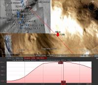
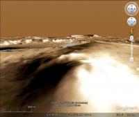
I know the altitude data on Google Earth are very coarse but, just completing what Stu already said, here's a vertical profile of a line directly connecting the landing site to the summit and showing that it is out of the line of sight (should we call it "Hidden Peak"?).
|
|
|
|
|
|
|
Aug 18 2012, 02:06 PM
Post
#52
|
|
|
The Poet Dude Group: Moderator Posts: 5551 Joined: 15-March 04 From: Kendal, Cumbria, UK Member No.: 60 |
QUOTE (climber @ Aug 18 2012, 01:25 PM) Stu (and all), can you please point out what you think will hidden our view? Written about this on my blog, if you'd like to take a look... http://galegazette.wordpress.com/2012/08/18/making-plans -------------------- |
|
|
|
|
Aug 18 2012, 02:16 PM
Post
#53
|
||
|
The Poet Dude Group: Moderator Posts: 5551 Joined: 15-March 04 From: Kendal, Cumbria, UK Member No.: 60 |
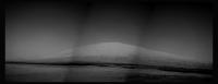
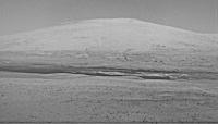
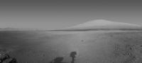
New pics down... first 'proper' view of Mt Sharp... (well, the front of it anyway!
)
-------------------- |
|
|
|
|
|
|
Aug 18 2012, 02:44 PM
Post
#54
|
||
|
Solar System Cartographer Group: Members Posts: 10173 Joined: 5-April 05 From: Canada Member No.: 227 |
Here's a processed view of the mountain.
Phil
-------------------- ... because the Solar System ain't gonna map itself.
Also to be found posting similar content on https://mastodon.social/@PhilStooke Maps for download (free PD: https://upload.wikimedia.org/wikipedia/comm...Cartography.pdf NOTE: everything created by me which I post on UMSF is considered to be in the public domain (NOT CC, public domain) |
|
|
|
|
|
|
Aug 18 2012, 03:01 PM
Post
#55
|
||
|
Senior Member Group: Members Posts: 4247 Joined: 17-January 05 Member No.: 152 |
And here's an average of L and R frames, which has reduced jpeg noise quite a bit (I had to rotate and scale one frame to register them well):
Enhance/mosaic as you see fit! |
|
|
|
|
|
|
Aug 18 2012, 03:38 PM
Post
#56
|
||
|
Newbie Group: Members Posts: 8 Joined: 21-April 12 Member No.: 6382 |
PS is giving issues with panorama blending, so here is my best shot with subtle enhancement and matching of layers for the full 3 frame composite.
-------------------- |
|
|
|
|
|
|
Aug 18 2012, 03:49 PM
Post
#57
|
|
|
Administrator Group: Admin Posts: 5172 Joined: 4-August 05 From: Pasadena, CA, USA, Earth Member No.: 454 |
My version. It's been a while since I did my own Mars rover image processing!

-------------------- My website - My Patreon - @elakdawalla on Twitter - Please support unmannedspaceflight.com by donating here.
|
|
|
|
|
Aug 18 2012, 03:58 PM
Post
#58
|
|
 Member Group: Members Posts: 267 Joined: 5-February 06 Member No.: 675 |
QUOTE (elakdawalla @ Aug 18 2012, 10:49 AM) My version. It's been a while since I did my own Mars rover image processing! Emily,Very nice job of nursing good detail out of 7-bit data with JPEG artifacts. Steve M |
|
|
|
|
Aug 18 2012, 04:01 PM
Post
#59
|
|
|
The Poet Dude Group: Moderator Posts: 5551 Joined: 15-March 04 From: Kendal, Cumbria, UK Member No.: 60 |
QUOTE (elakdawalla @ Aug 18 2012, 04:49 PM) My version. It's been a while since I did my own Mars rover image processing! Very nice, Emily, easily best yet
-------------------- |
|
|
|
|
Aug 18 2012, 05:36 PM
Post
#60
|
|
|
Senior Member Group: Members Posts: 2087 Joined: 13-February 10 From: Ontario Member No.: 5221 |
|
|
|
|
|
Aug 18 2012, 05:36 PM
Post
#61
|
|
|
Senior Member Group: Members Posts: 2922 Joined: 14-February 06 From: Very close to the Pyrénées Mountains (France) Member No.: 682 |
QUOTE (climber @ Aug 18 2012, 02:25 PM) Stu (and all), can you please point out what you think will hidden our view?I'm trying to find the maximum altitude we'll see in order to match this with a similar view on Earth. It is actully difficult to find a view with ~ 5500m altitude difference, so if the real difference is much less, it'll make search easier and comparison real. Thanks all for you input. I think the best equivalent picture will be of Mauna Loa or Mauna Kea in Hawaii at a distance of about 20km from the summit. The altitude (~ 4000m) would be about right. I'll try to find that and see how it compares. Any better idea welcomed. climber 
-------------------- |
|
|
|
|
Aug 18 2012, 06:10 PM
Post
#62
|
|
|
Founder Group: Chairman Posts: 14432 Joined: 8-February 04 Member No.: 1 |
It's just like any other mountain - you very rarely see the absolute summit till you're on it.
|
|
|
|
|
Aug 18 2012, 06:20 PM
Post
#63
|
||
|
Senior Member Group: Members Posts: 4247 Joined: 17-January 05 Member No.: 152 |
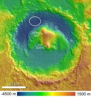
QUOTE (Tesheiner @ Aug 18 2012, 01:12 PM) here's a vertical profile of a line directly connecting the landing site to the summit and showing that it is out of the line of sight I thought that the true summit was farther south, more or less dead centre in Gale:
This elevation map and GM seem to agree that that's the highest point. Your summit corresponds to the "northern spur". Either way, both "local maxima" will likely remain out of sight for a very long time. Although the "true summit" is sharper, so it might be easier to see from afar... |
|
|
|
|
|
|
Aug 18 2012, 06:33 PM
Post
#64
|
||
|
The Poet Dude Group: Moderator Posts: 5551 Joined: 15-March 04 From: Kendal, Cumbria, UK Member No.: 60 |
QUOTE (fredk @ Aug 18 2012, 07:20 PM) I thought that the true summit was farther south, more or less dead centre in Gale: That's what I'm going by, too...
-------------------- |
|
|
|
|
|
|
Aug 18 2012, 07:08 PM
Post
#65
|
|
|
Senior Member Group: Moderator Posts: 4279 Joined: 19-April 05 From: .br at .es Member No.: 253 |
Yeah, I was afraid of that.
QUOTE (elakdawalla @ Aug 18 2012, 05:49 PM) My version. As mentioned before, we need something as a sort of scale to give an idea of the size / distance: Liberty Statue, Eiffel Tower, Burj Dubai. |
|
|
|
|
Aug 18 2012, 07:47 PM
Post
#66
|
||
 Member Group: Members Posts: 691 Joined: 21-December 07 From: Clatskanie, Oregon Member No.: 3988 |
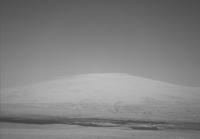
Ladies and Gentlemen....Mount Sharp from Navcam!
Ahh drats...Was already beatin to it.
|
|
|
|
|
|
|
Aug 18 2012, 07:51 PM
Post
#67
|
|
|
The Poet Dude Group: Moderator Posts: 5551 Joined: 15-March 04 From: Kendal, Cumbria, UK Member No.: 60 |
QUOTE (James Sorenson @ Aug 18 2012, 08:47 PM) Ladies and Gentlemen....Mount Sharp from Navcam! Where have you been? We got here hours ago!  Lovely image James. -------------------- |
|
|
|
|
Aug 18 2012, 07:55 PM
Post
#68
|
|
|
Administrator Group: Admin Posts: 5172 Joined: 4-August 05 From: Pasadena, CA, USA, Earth Member No.: 454 |
QUOTE (James Sorenson @ Aug 18 2012, 11:47 AM) Ladies and Gentlemen....Mount Sharp from Navcam! Ahh drats...Was already beatin to it. Your sky is better than mine. I tried to remove vignetting with the filter in Photoshop but it was still imperfect, and the sky had a periodic darkening that I attempted to remove (with some but not complete success) with the dodge tool. How do you de-vignette the images? -------------------- My website - My Patreon - @elakdawalla on Twitter - Please support unmannedspaceflight.com by donating here.
|
|
|
|
|
Aug 18 2012, 08:07 PM
Post
#69
|
|
|
Member Group: Members Posts: 691 Joined: 21-December 07 From: Clatskanie, Oregon Member No.: 3988 |
QUOTE (Stu @ Aug 18 2012, 11:51 AM) Where have you been? We got here hours ago! Lovely image James. Obviously not on this planet...  Thank you Stu QUOTE (elakdawalla @ Aug 18 2012, 11:55 AM) How do you de-vignette the images? PTgui has an option for Vignetting Correction. |
|
|
|
|
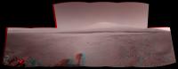
Aug 18 2012, 08:11 PM
Post
#70
|
||
|
Founder Group: Chairman Posts: 14432 Joined: 8-February 04 Member No.: 1 |
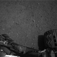
It's been a long way, but we're here.
Attached thumbnail(s)
|
|
|
|
|
|
|
Aug 18 2012, 08:30 PM
Post
#71
|
|
|
Administrator Group: Admin Posts: 5172 Joined: 4-August 05 From: Pasadena, CA, USA, Earth Member No.: 454 |
OK, that's terrific. Since this is obviously so easy for you, can you please do it in stereo?
-------------------- My website - My Patreon - @elakdawalla on Twitter - Please support unmannedspaceflight.com by donating here.
|
|
|
|
|
Aug 18 2012, 08:43 PM
Post
#72
|
||
|
Founder Group: Chairman Posts: 14432 Joined: 8-February 04 Member No.: 1 |
Filling in the sky's not worth it - but I think this works.
(You were not expecting that were you One thing they probably didn't think of was the MER heritage for Navcam...carries over to experience of us amateurs stitching those Navcam images for 8 years )
Attached thumbnail(s)
|
|
|
|
|
|
|
Aug 18 2012, 09:34 PM
Post
#73
|
|
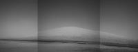
 Senior Member Group: Members Posts: 1619 Joined: 12-February 06 From: Bergerac - FR Member No.: 678 |
First, thank you Emily for publishing on your blog
Visits on my blog has rizing very fast  Second, I've updated my full panoramic with the Sol 12 Navcam pics. So now, Mount Sharp is not blur 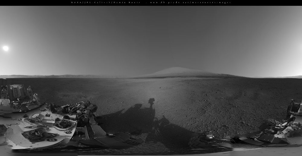
-------------------- |
|
|
|
|
Aug 18 2012, 10:31 PM
Post
#74
|
|
 Senior Member Group: Members Posts: 2492 Joined: 15-January 05 From: center Italy Member No.: 150 |
Excellent job, Damien... charmant!
-------------------- I always think before posting! - Marco -
|
|
|
|
|
Aug 19 2012, 01:46 AM
Post
#75
|
|
|
Member Group: Members Posts: 315 Joined: 1-October 06 Member No.: 1206 |
OK, there's NO rigor on this, but I did want to raise the idea of comparing the scene of Mt Sharp with a terrestrial scene of similar vertical scale.
Here's a stock shot of Kilimanjaro, taken at I believe a roughly similar distance, side by side with a hasty colorised crop from Doug's post. The scales here aren't identical, but I think comparing portions of the Mastcams when they arrive with terrestrial scenes of similar scale will be very useful. The scale of Mt Hadley was really hard to process with Apollo 15 (no trees, streams, buildings, haze, normal signs of erosion etc to compare it with), here we have an atmosphere, but its still hard to really get a feel from the scale of the scene.  P |
|
|
|
|
Aug 19 2012, 02:49 AM
Post
#76
|
||
|
Senior Member Group: Members Posts: 4247 Joined: 17-January 05 Member No.: 152 |
OK, the shy but welcoming mystery man has finally come out to great the new arival! And he brings with him several copies of a particular tower to help us get a sense of scale:
The tower is about a third of a km tall (324 m exactly), just like the real Eiffel tower. The closest tower is 2 km away, and the farthest two are about 70-75 km. For the highest visible point I used 20 km from Tesheiner's profile. The background is Ant's fantastic mosaic. |
|
|
|
|
|
|
Aug 19 2012, 02:53 AM
Post
#77
|
|
|
Merciless Robot Group: Admin Posts: 8784 Joined: 8-December 05 From: Los Angeles Member No.: 602 |
Great to see MM again, and glad he brought his towers! Thanks, Fred!
-------------------- A few will take this knowledge and use this power of a dream realized as a force for change, an impetus for further discovery to make less ancient dreams real.
|
|
|
|
|
Aug 19 2012, 03:21 AM
Post
#78
|
|
|
Member Group: Members Posts: 315 Joined: 1-October 06 Member No.: 1206 |
MASSIVE help. Thanks Fred!
p |
|
|
|
|
Aug 19 2012, 03:34 AM
Post
#79
|
|
 Senior Member Group: Members Posts: 3419 Joined: 9-February 04 From: Minneapolis, MN, USA Member No.: 15 |
Thanks, Fred. The Mystery Man and les Tours Eiffel (I hope I didn't massacre that spelling too badly) give a truly fine sense of scale to the scene.
Which leads me to another thing that I've been wondering about ever since the first navcam pan came down. The rim of Gale is obviously a lot closer to the north and west than to the south and east, but as you look directly east, at the far rim wall and past the rising flank of Mt. Sharp, the rim (and even the rise of the lower mound) become very indistinct, as if there is an awful lot of haze in the air in that direction. The haze layer straight to the west only obscures perhaps the lower 20% of the rim, while it obscures the entire rim to the east. I know this could simply be an artifact of sun angle and the angle through which we are looking at a relatively uniform haze layer. But it strikes me that this could be evidence of strong prevailing winds from the east that flow around the rim, kicking dust over the east rim that then slowly settles closer to the ground as it circulates around the crater. I'll be interested in seeing images of the rim from higher up on the mound, at different times of day and also at different times of year. -the other Doug -------------------- The trouble ain't that there is too many fools, but that the lightning ain't distributed right. -Mark Twain
|
|
|
|
|
Aug 19 2012, 09:37 AM
Post
#80
|
||
|
Senior Member Group: Members Posts: 2922 Joined: 14-February 06 From: Very close to the Pyrénées Mountains (France) Member No.: 682 |
I LOVE the latest panoramas as well as Fred references.
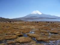
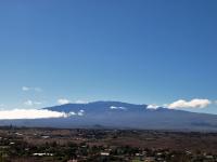
Nevertheless, I'm a mountain guy and I can't get it right with what I see here (this is due to the widest angle of the camera as compared to human eyes) even if I think Antipode comparison is about right. The highest point we can see on Mt Sharp is 4000m high and 20 kms away which give a visual angle of 11°5 (Fred correct me is I'm wrong). I include here a picture of Parinacota volcano (6348m) in Northern Chile I took at 4500m from 10 kms to the summit which give the same visual angle ~11.5°. Camera settings is 30mm comparable to Curiosity's. I hope it'll help even if the moutain itself is a lot "sharper" specialy on the left hand side (while it looks like Mt Sharp on the right).
It's "Tour" without an "s" ODoug... -------------------- |
|
|
|
|
|
|
Aug 19 2012, 09:47 AM
Post
#81
|
||
|
Senior Member Group: Members Posts: 2922 Joined: 14-February 06 From: Very close to the Pyrénées Mountains (France) Member No.: 682 |
Well, this HAS to be much better. I Googled "Mauna Kea seen from Waimea" since there is a 4000m altitude difference and a 20km distance + a much better visuel match with Mt Sharp
Edited: note that we can see the observatories which give also a sense of scale Camera Make : OLYMPUS IMAGING CORP. Camera Model : E-510 Focal Length : 24 mm -------------------- |
|
|
|
|
|
|
Aug 19 2012, 09:50 AM
Post
#82
|
|
|
The Poet Dude Group: Moderator Posts: 5551 Joined: 15-March 04 From: Kendal, Cumbria, UK Member No.: 60 |
QUOTE (fredk @ Aug 19 2012, 03:49 AM) OK, the shy but welcoming mystery man has finally come out to great the new arival! And he brings with him several copies of a particular tower to help us get a sense of scale: BRILLIANT! Thank you, that's mega helpful. -------------------- |
|
|
|
|
Aug 19 2012, 02:00 PM
Post
#83
|
|
|
Member Group: Members Posts: 311 Joined: 31-August 05 From: Florida & Texas, USA Member No.: 482 |
According to the silly N165 twitter, the rover made a short drive and has begun firing the laser. I cannot find any substantial updates yet though. Assuming it's all working, this Sol is a huge commissioning checkout.
|
|
|
|
|
Aug 19 2012, 02:00 PM
Post
#84
|
|
|
Junior Member Group: Members Posts: 59 Joined: 12-March 10 From: Austin, TX Member No.: 5262 |
I find these pictures both very helpful and very distressing. No wonder it's going to take FOREVER to get to even the base of Sharp!
|
|
|
|
|
Aug 19 2012, 02:08 PM
Post
#85
|
|
|
Newbie Group: Members Posts: 3 Joined: 12-August 12 From: Berlin Member No.: 6547 |
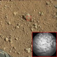
Chemcam Sol 13 images are up! http://mars.jpl.nasa.gov/msl/multimedia/ra...era=CHEMCAM_RMI
Could this be a hole in n165: http://mars.jpl.nasa.gov/msl/multimedia/ra...6013M_&s=13 ? hope so ; ) |
|
|
|
|
Aug 19 2012, 02:09 PM
Post
#86
|
|
|
Junior Member Group: Members Posts: 61 Joined: 5-June 05 From: 46.283N 11.433E :)) Member No.: 401 |
QUOTE (fredk @ Aug 19 2012, 04:49 AM) OK, the shy but welcoming mystery man has finally come out to great the new arival! Fantastic work! Could you add some other mystery men in the area in front of the closest tower? I mean between 0 and 2000m. Thank you |
|
|
|
|
Aug 19 2012, 02:13 PM
Post
#87
|
|
|
Member Group: Members Posts: 282 Joined: 18-June 04 Member No.: 84 |
QUOTE (Marz @ Aug 19 2012, 03:00 PM) According to the silly N165 twitter, the rover made a short drive and has begun firing the laser. I cannot find any substantial updates yet though. Assuming it's all working, this Sol is a huge commissioning checkout. Is someone on the science team behind that twitter account? |
|
|
|
|
Aug 19 2012, 03:50 PM
Post
#88
|
|
|
Senior Member Group: Members Posts: 4247 Joined: 17-January 05 Member No.: 152 |
QUOTE (malgar @ Aug 19 2012, 02:09 PM) Fantastic work! Could you add some other mystery men in the area in front of the closest tower? Thanks! I wanted to add more men but I found it hard to make identifications between the foreground and orbital views. Hopefully Glenelg will have more obvious features to match... |
|
|
|
|
Aug 19 2012, 04:38 PM
Post
#89
|
|
|
Administrator Group: Admin Posts: 5172 Joined: 4-August 05 From: Pasadena, CA, USA, Earth Member No.: 454 |
QUOTE (djellison @ Aug 18 2012, 12:43 PM) (You were not expecting that were you One thing they probably didn't think of was the MER heritage for Navcam...carries over to experience of us amateurs stitching those Navcam images for 8 years )Wondrous! Regarding the chemcam stuff -- first of all, the Twitter account is not by a member of the science team. The "short drive" should've been a giveaway. In the first place, you wouldn't drive before ChemCamming; that would mess up your pointing. Second, we know the rover hasn't been driven yet; they still need to do actuator tests and their short bump before commanding anything intentional. As far as the ChemCam images go, as far as I can tell, they are not of a lasered rock. Whenever you see a ChemCam image that you can't figure out, look for a corresponding Left Navcam image taken at the same time for context. The three different ChemCam images are related to Navcam images of a little rock; one of the rocket-blasted areas; and of a patch of soil. -------------------- My website - My Patreon - @elakdawalla on Twitter - Please support unmannedspaceflight.com by donating here.
|
|
|
|
|
Aug 19 2012, 05:25 PM
Post
#90
|
||
|
The Poet Dude Group: Moderator Posts: 5551 Joined: 15-March 04 From: Kendal, Cumbria, UK Member No.: 60 |
Processed views of the CC images...
-------------------- |
|
|
|
|
|
|
Aug 19 2012, 05:31 PM
Post
#91
|
||
|
Newbie Group: Members Posts: 2 Joined: 12-March 07 Member No.: 1859 |
Apologies if this has been mentioned before, but regarding this image (also attached):
http://mars.jpl.nasa.gov/msl-raw-images/pr...NCAM15000M_.JPG Looking in the lower-right quadrant of the lower-left quadrant: that roundel with the JPL logo on it: is this post-flight damage? Or was that scar there before launch? Really enjoying seeing all the images, guys, thanks a ton! -- jgb
Attached thumbnail(s)
|
|
|
|
|
|
|
Aug 19 2012, 05:34 PM
Post
#92
|
|
|
Merciless Robot Group: Admin Posts: 8784 Joined: 8-December 05 From: Los Angeles Member No.: 602 |
Looks like a dust smudge from the landing to me. Notice that there's a dust 'shadow' behind the disc itself on the beam.
-------------------- A few will take this knowledge and use this power of a dream realized as a force for change, an impetus for further discovery to make less ancient dreams real.
|
|
|
|
|
Aug 19 2012, 05:37 PM
Post
#93
|
|
 Senior Member Group: Members Posts: 3648 Joined: 1-October 05 From: Croatia Member No.: 523 |
-------------------- |
|
|
|
|
Aug 19 2012, 06:17 PM
Post
#94
|
|
|
Senior Member Group: Members Posts: 1465 Joined: 9-February 04 From: Columbus OH USA Member No.: 13 |
Thanks! do you happen to know which raw image(s) contain the first chemcam target N165? Space.com shows a mosaic of mastcam images, but I can't find the corresponding image in the mastcam raws that have been released. Easy to overlook a little rock though.
EDIT: found it--it's in the upper left quadrant of this image: http://mars.jpl.nasa.gov/msl-raw-images/ms...4000E1_DXXX.jpg -------------------- |
|
|
|
|
Aug 19 2012, 06:23 PM
Post
#95
|
|
|
Senior Member Group: Members Posts: 3648 Joined: 1-October 05 From: Croatia Member No.: 523 |
As Emily already pointed out, I think neither of the 3 (newest) images actually show N165.
-------------------- |
|
|
|
|
Aug 19 2012, 06:34 PM
Post
#96
|
|
|
The Poet Dude Group: Moderator Posts: 5551 Joined: 15-March 04 From: Kendal, Cumbria, UK Member No.: 60 |
QUOTE (jmknapp @ Aug 19 2012, 07:17 PM) Thanks! do you happen to know which raw image(s) contain the first chemcam target N165? http://mars.jpl.nasa.gov/msl-raw-images/ms...4000E1_DXXX.jpg -------------------- |
|
|
|
|
Aug 19 2012, 07:12 PM
Post
#97
|
|
|
Member Group: Members Posts: 470 Joined: 24-March 04 From: Finland Member No.: 63 |
I think the Chemcam laser has fired. At least there seems to be a new spot on the calibration target.
Sol 12: http://mars.jpl.nasa.gov/msl-raw-images/pr...CCAM02012M_.JPG Sol 13: http://mars.jpl.nasa.gov/msl-raw-images/pr...CCAM03013M_.JPG So she shot herself :-P -------------------- Antti Kuosmanen
|
|
|
|
|
Aug 19 2012, 09:17 PM
Post
#98
|
|
|
Solar System Cartographer Group: Members Posts: 10173 Joined: 5-April 05 From: Canada Member No.: 227 |
Confirmed now - they shot N165 and renamed it Coronation, sol 13. Did we get a steering test?
Phil -------------------- ... because the Solar System ain't gonna map itself.
Also to be found posting similar content on https://mastodon.social/@PhilStooke Maps for download (free PD: https://upload.wikimedia.org/wikipedia/comm...Cartography.pdf NOTE: everything created by me which I post on UMSF is considered to be in the public domain (NOT CC, public domain) |
|
|
|
|
Aug 19 2012, 09:58 PM
Post
#99
|
|
|
Member Group: Members Posts: 813 Joined: 29-December 05 From: NE Oh, USA Member No.: 627 |
Chemcan did indeed....
http://www.jpl.nasa.gov/news/news.cfm?release=2012-248 "We got a great spectrum of Coronation -- lots of signal," said ChemCam Principal Investigator Roger Wiens of Los Alamos National Laboratory, N.M. "Our team is both thrilled and working hard, looking at the results. After eight years building the instrument, it's payoff time!" ChemCam recorded spectra from the laser-induced spark at each of the 30 pulses..... "It's surprising that the data are even better than we ever had during tests on Earth, in signal-to-noise ratio," said ChemCam Deputy Project Scientist Sylvestre Maurice of the Institut de Recherche en Astrophysique et Planetologie (IRAP) in Toulouse, France. "It's so rich, we can expect great science from investigating what might be thousands of targets with ChemCam in the next two years." No word yet on steering test. Craig |
|
|
|
|
Aug 20 2012, 10:29 AM
Post
#100
|
|
|
Junior Member Group: Members Posts: 39 Joined: 9-August 12 From: London, UK Member No.: 6521 |
Hi all - great forum and amazing resource; just de-lurked to ask a question, but also congrats to the whole MSL team for an amazing achievement and looking forward to all the science to follow.
Basically is there anywhere JPL posts a "sol-by-sol" list of what's planned in terms of surface operations for Curiosity for the next few sols? |
|
|
|
|

|
Lo-Fi Version | Time is now: 1st June 2024 - 04:51 AM |
|
RULES AND GUIDELINES Please read the Forum Rules and Guidelines before posting. IMAGE COPYRIGHT |
OPINIONS AND MODERATION Opinions expressed on UnmannedSpaceflight.com are those of the individual posters and do not necessarily reflect the opinions of UnmannedSpaceflight.com or The Planetary Society. The all-volunteer UnmannedSpaceflight.com moderation team is wholly independent of The Planetary Society. The Planetary Society has no influence over decisions made by the UnmannedSpaceflight.com moderators. |
SUPPORT THE FORUM Unmannedspaceflight.com is funded by the Planetary Society. Please consider supporting our work and many other projects by donating to the Society or becoming a member. |
|