Geomorphology of Cape York and Solander Point, Examining Opportunity's destination at Endeavour Crater |

  |
Geomorphology of Cape York and Solander Point, Examining Opportunity's destination at Endeavour Crater |
 Jul 6 2010, 07:52 PM Jul 6 2010, 07:52 PM
Post
#1
|
||
 The Poet Dude  Group: Moderator Posts: 5551 Joined: 15-March 04 From: Kendal, Cumbria, UK Member No.: 60 |
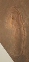
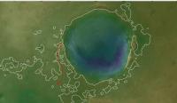
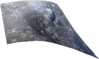
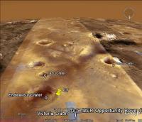
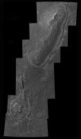
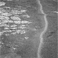
Everyone, say hello to Cape York... in colour...
Larger version on my blog: http://roadtoendeavour.wordpress.com/2010/...-york-in-colour -------------------- |
|
 |
 
|
|
|
Jul 6 2010, 10:26 PM
Post
#2
|
|
 Senior Member Group: Admin Posts: 4763 Joined: 15-March 05 From: Glendale, AZ Member No.: 197 |
QUOTE (Stu @ Jul 6 2010, 12:52 PM)  Everyone, say hello to Cape York... in colour... Thanks Stu. I've got my route and investigation sites all picked out. Only thing left now is getting my hands on the controls. -------------------- If Occam had heard my theory, things would be very different now.
|
|
|
|
|
Jul 7 2010, 05:37 PM
Post
#3
|
||
 Member Group: Members Posts: 656 Joined: 20-April 05 From: League City, Texas Member No.: 285 |
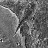
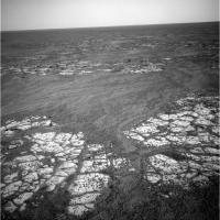
QUOTE (Stu @ Jul 6 2010, 01:52 PM) ...Cape York... in colour... ... This is a great picture, with fascinating geology going on. For instance, being a crater rim, I would not expect neat layering; I find it difficult to explain the "ringing" about Cape York in a manner other than waterlines. I see at least 4 major levels. I'd love to see this in 3D. At the upper end there is a steep wedge-shaped incision (see highlighted image below). Note that the wedge cuts through at least two of the "rings", and appears to project a fair distance to the north (?). I'm inclined interpret it as a landslide, but having difficulty with the mechanism; I suppose it could be an eroded fracture. In the highlighted image, the point of the wedge has its origin between the highlighted green and blue rings; this region is very smooth, such that I am tempted to interpret it as the remains of a beach. Sheer speculation, of course  Overall, the northern end of Cape York looks the most interesting, and I very much look forward to a pic from Oppy looking down on the Wedge. Overall, the northern end of Cape York looks the most interesting, and I very much look forward to a pic from Oppy looking down on the Wedge.
|
|
|
|
|
|
|
Jul 7 2010, 06:18 PM
Post
#4
|
|
|
Solar System Cartographer Group: Members Posts: 10166 Joined: 5-April 05 From: Canada Member No.: 227 |
Those rings - don't think waterlines, the topography doesn't work - it's on a slope. Think instead: a very ancient crater rim that has had multiple layers of sediment (ejecta, windblown sand or dust, volcanic ash, etc.) deposited, cemented by fluctuating ground waters, and then differentially eroded. We see the end product of multiple depositional and erosional events.
Phil -------------------- ... because the Solar System ain't gonna map itself.
Also to be found posting similar content on https://mastodon.social/@PhilStooke Maps for download (free PD: https://upload.wikimedia.org/wikipedia/comm...Cartography.pdf NOTE: everything created by me which I post on UMSF is considered to be in the public domain (NOT CC, public domain) |
|
|
|
|
Jul 7 2010, 06:28 PM
Post
#5
|
|
 Member Group: Members Posts: 404 Joined: 5-January 10 Member No.: 5161 |
QUOTE (Phil Stooke @ Jul 7 2010, 10:18 AM) We see the end product of multiple depositional and erosional events. Eroded by wind only is that right? |
|
|
|
|
Jul 7 2010, 06:33 PM
Post
#6
|
|
|
Member Group: Members Posts: 656 Joined: 20-April 05 From: League City, Texas Member No.: 285 |
This sounds sensible, with the caveat that slopes may be historically variable. You're almost certainly correct, though with the presence of groundwater presumed historically in the region where Oppy has heretofore traversed, and with (at least the interior of) Endeavour being dramatically lower, I would hesitate to definitively rule-out surface water until we get some on-the-ground verification. Aside from that, I'm still really intrigued by the Wedge.
|
|
|
|
|
Jul 7 2010, 08:47 PM
Post
#7
|
||
|
Senior Member Group: Admin Posts: 4763 Joined: 15-March 05 From: Glendale, AZ Member No.: 197 |
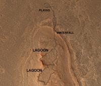
QUOTE (algorimancer @ Jul 7 2010, 10:37 AM) At the upper end there is a steep wedge-shaped incision (see highlighted image below). With regard to the "wedge-shaped" cut...if you ask me I see a sinuous channel above the wedge and slightly east that you can follow up to the two depressions at the top of the formation. I've been staring at this for months and (call me crazy, go ahead) I can imagine the whole region covered in a slowly receding body of water. The rim of Endeavour would at first have been something like a circular archipelago. As the water level receded you could see how two lagoons might have formed in those depressions. They might later have become lakes or ponds as the water receded almost to the base of Cape York. If something caused those those lagoons to drain suddenly to the north, you would get a meandering stream on the slope, but when it reached the steeper ledge of the apron it would have been a more energetic stream or even a waterfall that would have eroded backward creating the wedge. You can also see how the channel becomes broader at the base of the cut where the slope becomes more gradual, creating something akin to an alluvial fan or a mini-delta. If you follow on past the wedge you can almost see a small round low lying basin next to a crater where the water might have collected before evaporating or settling into an underground water table.
Attached thumbnail(s)
-------------------- If Occam had heard my theory, things would be very different now.
|
|
|
|
|
|
|
Jul 7 2010, 09:27 PM
Post
#8
|
|
|
Senior Member Group: Members Posts: 3516 Joined: 4-November 05 From: North Wales Member No.: 542 |
Somewhere we have already had a nice stratigrapher's resume of these features but the interpretation there was that the 'waterfall stream' arrived at the wedge after flowing round the E flank of Cape York where there is indeed what looks like a narrow channel where the hill slope meets the 'beach' platform. Can I find the post? No.
 Anyone remember it? We could use a link back to that, and the discussion it was part of. EDIT: Gottit! http://www.unmannedspaceflight.com/index.p...st&p=156342 |
|
|
|
|
Jul 7 2010, 10:04 PM
Post
#9
|
|
|
Senior Member Group: Members Posts: 2998 Joined: 30-October 04 Member No.: 105 |
+1 on Phil's observation: "Think instead: a very ancient crater rim that has had multiple layers of sediment ".
--Bill -------------------- |
|
|
|
|
Jul 7 2010, 10:50 PM
Post
#10
|
|
|
The Poet Dude Group: Moderator Posts: 5551 Joined: 15-March 04 From: Kendal, Cumbria, UK Member No.: 60 |
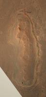
Some of you might find this useful... bit less blurry than the colour version...
http://twitpic.com/23b8o7 -------------------- |
|
|
|
|
Jul 8 2010, 03:46 AM
Post
#11
|
|
|
Senior Member Group: Members Posts: 1044 Joined: 17-February 09 Member No.: 4605 |
The rim of Endeavour is really eroded and the meridiani hematite sedimentary beds fill much of the interior floor. Since the crater is lower than the playa region examined to date is it beyond the bounds of possibility that Endeavour region did in fact have a shallow lake?
|
|
|
|
|
Jul 8 2010, 07:23 AM
Post
#12
|
|
 Member Group: Members Posts: 754 Joined: 9-February 07 Member No.: 1700 |
The pic from Stu's post 570 sure makes the Wedge look more like a fracture than a tributary or conduit for water.
|
|
|
|
|
Jul 8 2010, 07:26 AM
Post
#13
|
|
|
Senior Member Group: Members Posts: 2998 Joined: 30-October 04 Member No.: 105 |
Any possibilities are, well, possible. We'll need to see what the nature (stratigraphy, petrology and depositional environment) of the bedrock outcrops is as we travel downhill. Already we see subtle changes and the gross appearance from orbital imagery changes towards the East.
--Bill -------------------- |
|
|
|
|
Jul 8 2010, 02:35 PM
Post
#14
|
|
|
Member Group: Members Posts: 293 Joined: 29-August 06 From: Columbia, MD Member No.: 1083 |
What are the approximate dimensions of Cape York? Length, height, width... Thanks!
|
|
|
|
|
Jul 8 2010, 03:15 PM
Post
#15
|
|
|
The Poet Dude Group: Moderator Posts: 5551 Joined: 15-March 04 From: Kendal, Cumbria, UK Member No.: 60 |
VERY roughly, 660m long by 160m wide. Height? Image is too blurry on Google Earth to tell.
-------------------- |
|
|
|
|
Jul 8 2010, 03:19 PM
Post
#16
|
|
|
Member Group: Members Posts: 656 Joined: 20-April 05 From: League City, Texas Member No.: 285 |
A waterfall .... now, that's a neat idea. I'd envisioned a little rivulet gradually eroding the Wedge, but I rather like the waterfall idea.
A good stereo pair would be really helpful. That, or activate Oppy's heretofore unused (and undiscussed) JATO rockets to get there faster
|
|
|
|
|
Jul 8 2010, 03:28 PM
Post
#17
|
|
|
Member Group: Members Posts: 890 Joined: 18-November 08 Member No.: 4489 |
waterfall , i guess it is time to start to rethink my very old "blue mars" map so the next time some one wants to put it on a discovery chan show it will be " more" correct.
|
|
|
|
|
Jul 8 2010, 03:33 PM
Post
#18
|
||
|
Member Group: Members Posts: 656 Joined: 20-April 05 From: League City, Texas Member No.: 285 |
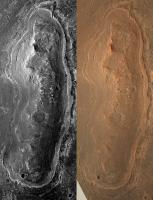
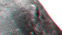
Well, I said a "good" stereo pair would be helpful. Here's a cross-eyed pair, using the last couple of images posted. These may be from the same image, for all I know, but I'm pretty sure I'm getting a stereo effect, particularly around the Wedge. Overall quality is not great, but it's something different.
|
|
|
|
|
|
|
Jul 8 2010, 03:39 PM
Post
#19
|
|
|
Solar System Cartographer Group: Members Posts: 10166 Joined: 5-April 05 From: Canada Member No.: 227 |
I guess my reason for preferring a non-shoreline model is that I'm doubtful that an open body of water could have existed for long enough to create typical shoreline features like beaches, or that it would have been covered with ice, or that unconsolidated deposits like beaches could remain recognizable after all this time. Erosion might be slow on Mars but it can still have an effect on loose material. But I'll agree that other explanations than mine are possible, so let's see what we find. It might be interesting to consider what landforms or deposits you would expect the rover to see if this is a beach rather than superimposed layered sediment.
(PS this isn't distant vistas any more...) Phil -------------------- ... because the Solar System ain't gonna map itself.
Also to be found posting similar content on https://mastodon.social/@PhilStooke Maps for download (free PD: https://upload.wikimedia.org/wikipedia/comm...Cartography.pdf NOTE: everything created by me which I post on UMSF is considered to be in the public domain (NOT CC, public domain) |
|
|
|
|
Jul 8 2010, 04:04 PM
Post
#20
|
|
|
Senior Member Group: Members Posts: 2998 Joined: 30-October 04 Member No.: 105 |
Phil, my take on this is the deposition of and differential erosion of strata of differing resistances, deposited as essentially flat-lying beds over a pre-existing hill. Use known processes and KISS until you have proof otherwise.
--Bill -------------------- |
|
|
|
|
Jul 8 2010, 04:49 PM
Post
#21
|
|
|
The Poet Dude Group: Moderator Posts: 5551 Joined: 15-March 04 From: Kendal, Cumbria, UK Member No.: 60 |
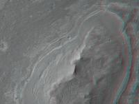
QUOTE (algorimancer @ Jul 8 2010, 04:19 PM) A good stereo pair would be really helpful. Ask, and ye shall receive... http://roadtoendeavour.files.wordpress.com...-york-in-3d.jpg -------------------- |
|
|
|
|
Jul 8 2010, 04:51 PM
Post
#22
|
|
|
The Poet Dude Group: Moderator Posts: 5551 Joined: 15-March 04 From: Kendal, Cumbria, UK Member No.: 60 |
QUOTE (Phil Stooke @ Jul 8 2010, 04:39 PM) (PS this isn't distant vistas any more...) I think discussing Cape York here is valid, as we're all just waiting to see it appear on the horizon as part of the "distant vista", but if others agree with you then I'd be fine with someone starting a "Cape York" thread. -------------------- |
|
|
|
|
Jul 8 2010, 05:02 PM
Post
#23
|
|
|
Senior Member Group: Admin Posts: 4763 Joined: 15-March 05 From: Glendale, AZ Member No.: 197 |
QUOTE (Stu @ Jul 8 2010, 09:51 AM) I'd be fine with someone starting a "Cape York" thread. So let it be written, so let it be done. -------------------- If Occam had heard my theory, things would be very different now.
|
|
|
|
|
Jul 8 2010, 05:26 PM
Post
#24
|
|
|
Member Group: Members Posts: 656 Joined: 20-April 05 From: League City, Texas Member No.: 285 |
Great stereo, Stu (much better than the one I improvised). The more I look at this, the more I think "beach". Consider that, if Endeavour were flooded, with the water extending beyond the current rim (so that Cape York was an island), the big open deep water would be to the east of Cape York, and consequently the major wave action would be from that direction. All along the east side of Cape York is what appears to be a longshore bar, which might be expected from that wave action. This feature is largely lacking to the west. It makes sense that, as the water declined, water which accumulated behind the bar would channelize and flow through gaps. While the Wedge seems most prominent, I also see signs of channels to the south of it (immediately below the apparent small crater in the "bar", and a smaller channel at the northern "point" of Cape York. I see signs of channels feeding into these 3 outlets which are traceable southwards beyond half the length of the Cape.
Here's a portion Wikipedia's description of beach geology: "There are several conspicuous parts to a beach, all of which relate to the processes that form and shape it. The part mostly above water (depending upon tide), and more or less actively influenced by the waves at some point in the tide, is termed the beach berm. The berm is the deposit of material comprising the active shoreline. The berm has a crest (top) and a face the latter being the slope leading down towards the water from the crest. At the very bottom of the face, there may be a trough, and further seaward one or more longshore bars: slightly raised, underwater embankments formed where the waves first start to break. The sand deposit may extend well inland from the berm crest, where there may be evidence of one or more older crests (the storm beach) resulting from very large storm waves and beyond the influence of the normal waves. At some point the influence of the waves (even storm waves) on the material comprising the beach stops, and if the particles are small enough (sand size or smaller) , winds shape the feature. Where wind is the force distributing the grains inland, the deposit behind the beach becomes a dune." |
|
|
|
|
Jul 8 2010, 05:30 PM
Post
#25
|
|
|
The Poet Dude Group: Moderator Posts: 5551 Joined: 15-March 04 From: Kendal, Cumbria, UK Member No.: 60 |
QUOTE (algorimancer @ Jul 8 2010, 06:26 PM) Great stereo, Stu (much better than the one I improvised). Thanks, but can't take credit for that; I just used the IAS Viewer to view the already-existing anaglyph of the area, then stitched together four close crops of it. Thanks to the amazing HiRISE team for the stunning images! -------------------- |
|
|
|
|
Jul 8 2010, 06:34 PM
Post
#26
|
|
|
Senior Member Group: Members Posts: 3516 Joined: 4-November 05 From: North Wales Member No.: 542 |
Back to something I mentioned before but, since at last we have a special thread and more people contributing, here it is once more. It's about the beach/not-beach issue. One sure way to demolish the beach idea is to show that any hypothetical Endeavour lake would have had an outflow at a lower level than this terrace. If on the other hand the outflow point is found to be very close to the level of the terrace this could be seen as a 'fulfilled prediction' of the beach hypothesis. Lakes that drain can have levels that are stable for long periods, whereas lakes that don't tend to fluctuate or steadily decrease in level, militating against significant beach formation like Phil said.
I'm surprised that no-one here has seriously grappled with the relative elevations. I've made my own clumsy attempt and I think the elevations are fairly close - but that's really not good enough. |
|
|
|
|
Jul 8 2010, 07:57 PM
Post
#27
|
|
|
Member Group: Members Posts: 656 Joined: 20-April 05 From: League City, Texas Member No.: 285 |
QUOTE (ngunn @ Jul 8 2010, 12:34 PM) ...I'm surprised that no-one here has seriously grappled with the relative elevations.... It seems like Google Mars with the MOLA elevation database and overlaid high resolution imagery ought to get close to an answer. It's too bad it doesn't have the explicit capability of adding a water layer at a particular elevation, though this might be improvised (I'm afraid I just don't have the time lately, else I'd try it). One issue with applying this to ancient times may be that previously saturated subsurface/sediments may have subsequently lost water to sublimation and consequently altered the topography. |
|
|
|
|
Jul 8 2010, 10:26 PM
Post
#28
|
|
 Senior Member Group: Members Posts: 1619 Joined: 12-February 06 From: Bergerac - FR Member No.: 678 |
Okay……
-------------------- |
|
|
|
|
Jul 8 2010, 11:18 PM
Post
#29
|
|
|
Founder Group: Chairman Posts: 14432 Joined: 8-February 04 Member No.: 1 |
I'm wondering if you could take word-pedantry to another website. Please, just don't have that discussion here, yet again.
|
|
|
|
|
Jul 8 2010, 11:19 PM
Post
#30
|
||
|
Newbie Group: Members Posts: 15 Joined: 28-November 08 From: Germany Member No.: 4498 |
QUOTE I'm surprised that no-one here has seriously grappled with the relative elevations. Here is an attempt using a DTM from HRSC data (H3198_0001_DT4.IMG), blended with the nadir view (H3198_0001_ND4.IMG). The hypothetical shoreline in shown in white. It is more or less equivalent to the -1480 m contour (estimated from Google Mars because I introduced some sort of offset during file convertion). I can´t find a contour that completely surrounds the hill in question, but that may be because of the resolution of the DTM. Still, this contour line implies a maximum depth of about 410 m for the lake, and some lagoons along the east rim (anyone want to look for shorelines?). Also, at this lake level the hypothetical lake would just begin to spill into a large basin to the southeast (along the red arrow; the contour lines begin to connect if the lake level is just a few meters higher). If the lake really spilled in that direction, I would expect to see some channels; but at a quick glance I don´t see any. EDIT: Used the correct data set now and changed attachment accordingly.
Attached thumbnail(s)
|
|
|
|
|
|
|
Jul 9 2010, 02:24 AM
Post
#31
|
|
|
Senior Member Group: Members Posts: 1044 Joined: 17-February 09 Member No.: 4605 |
Trying to confirm a shoreline after a few billion years of erosion is a bit of an ask. What I do find interesting is that Cape York and immediate surrounds have phyllosilicates which would seem to indicate a long lasting, non acidic water influence. in the deeper areas around Cape York are the typical Meridiani sulphates indicating a second sedimentary deposition. In this scenario equating phyllosolicates to permanent surface standing water is really seductive.
|
|
|
|
|
Jul 9 2010, 06:03 AM
Post
#32
|
|
|
Member Group: Members Posts: 184 Joined: 2-March 06 Member No.: 692 |
Just to toss in my 2 cents worth, when I look at cape york from above, I see the black hills of south dakota. They're a bit of old eroded mountain range complete with a "race track" of the spearfish formation forming a perifery around it. It's what a billion years of differential erosion will do. I know this is a crater rim but the same processes would apply. Any assymetries could be due to wind differences or the way the original crater rim was blasted out.
That cleft at the top is really interesting though!! |
|
|
|
|
Jul 9 2010, 08:45 AM
Post
#33
|
|
|
Senior Member Group: Members Posts: 3516 Joined: 4-November 05 From: North Wales Member No.: 542 |
QUOTE (algorimancer @ Jul 8 2010, 06:26 PM) beach geology I was using the word 'beach' in a very lazy way as shorthand for 'shoreline feature'. I realise that in a geomorphology thread that's inappropriate and I apologise for the sloppiness. What we may call the Cape York terrace (though it can actually be traced around much of the Endeavour rim) has to be a hard formation to have resisted erosion in the way it apparently has. The result of some sort of concretion process happening at the lake margin maybe, rather than loose material emplaced by wave action. Another possibility is that it marks the stable stand of an old water table from a time when the whole of Endeavour was filled with porous sediments. I also have been looking for signs of an outflow, but maybe in the wrong place. I thought the lowest gaps in the rim lay in the general direction of Iazu. There are some channel-like features there that appear to begin a short distance outside the crater and flow away from it. |
|
|
|
|
Jul 9 2010, 09:35 AM
Post
#34
|
|
|
Newbie Group: Members Posts: 15 Joined: 28-November 08 From: Germany Member No.: 4498 |
Judging from the DTM I used in post #30, the lake would start to spill through Torres Strait if the lake level were only about 10 - 15 m higher. But the valley winding around Cape Tribulation appears to be lower.
Regarding the billions of years of erosion, I remember that the erosion rates for the last 2.5 billion years are thought to be extremely low (can´t find that paper right now). Let me throw in two observations from my area: First, the South German Molasse Basin has a c. 15 million years old shoreline that is still, in places, a quite well-preserved terrace-like feature. And erosion rates are definitly higher than on Mars! I will look for numbers if you are interested. Second, since this is a crater rim, I´m not convinced that the rocks of Cape York formed at its present place. The Ries crater in Bavaria (24 km) is known to have ejected relatively intact blocks up to 1.5 km in size. If Cape York were such a block, its rocks could have formed at a much deeper topographic level, and before the Endeavour cratering event. So, the phyllosilicates may have formed much earlier, and could be totally unrelated to the hypothetical younger shoreline. |
|
|
|
|
Jul 9 2010, 11:00 AM
Post
#35
|
|
|
Senior Member Group: Members Posts: 3516 Joined: 4-November 05 From: North Wales Member No.: 542 |
Time for me to take another look at the Tribulation channel, viewing it as a possible exit. (In my mind's eye I had it flowing the other way.) Follow this link for Nirgal's 3D views of that location:
http://www.unmannedspaceflight.com/index.p...st&p=156417 |
|
|
|
|
Jul 13 2010, 07:01 AM
Post
#36
|
|
|
Member Group: Members Posts: 146 Joined: 31-October 08 Member No.: 4473 |
I have my doubts about wave erosion and shores, at least of a free liquid water surface during the briny times Endeavour was formed. I think Mars was too cold by then, any body of water would be mostly ice-covered. I do think that an ice-layer (maybe thin) over brine is worth considering. There could be a situation with the Martian atmosphere below the water triple point, but wet brine would exist under ice bound to the soil. If the brine started to pool, it would then evaporate, but the soil would stay wet, but no (or few) actual liquid pools. This wetness could mobilize the overlying ice layer if on or near a slope, and a little erosion could occur (remember the ramps and headlands of Victoria?). The rim of Endeavour has a different composition and is above the local water table, so it would have a different history. And any soil water would not have the same brine content. It would erode/be-overlain differently.
Remember also that Meridiani is not like many other areas of Mars, no other area of extensive Hematite anywhere near its size exists on Mars (there are a smattering of smaller areas). So its history is not the same as the ancient northern ocean. |
|
|
|
|
Feb 9 2011, 10:59 AM
Post
#37
|
|||
 Senior Member Group: Members Posts: 1088 Joined: 19-February 05 From: Close to Meudon Observatory in France Member No.: 172 |
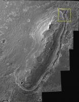
Stu, your mosaic is great !
Thanks to it, I realized that one of the most interesting geological features to be seen on Cape York is "Dagger Valley" (outlined in yellow, a name I'm humbly suggesting) : a big incision with many layers surely to be sampled, like inside a small canyon. It exploration would complement our understanding of the history of past climate on Mars, as well as of Cape York itself...
|
||
|
|
|
||
|
Feb 9 2011, 11:46 AM
Post
#38
|
|
|
Senior Member Group: Members Posts: 3516 Joined: 4-November 05 From: North Wales Member No.: 542 |
Just a reminder - link back to Nirgal's 3D featuring Dagger Valley: http://www.thethirdplanet.de/mars_gallery/...5/page-0004.htm
|
|
|
|
|
Feb 9 2011, 01:16 PM
Post
#39
|
|
 Senior Member Group: Members Posts: 2173 Joined: 28-December 04 From: Florida, USA Member No.: 132 |
QUOTE (vikingmars @ Feb 9 2011, 05:59 AM) ..."Dagger Valley" ...a big incision with many layers surely to be sampled, like inside a small canyon.... That certainly is an interesting feature. How it might have been formed, I have no clue. I'm not sure about the "layers" part though. If Cape York is part of Endeavour's rim, whatever layers may have existed before the impact are probably quite jumbled. I'm no crater rim morphology expert though.Then there's that "freshish" crater on the South end, with plenty of large ejecta blocks scattered about. Those are not likely to be blocks of the same Meridiani pavement that Opportunity has been traversing for years, but blocks of whatever yet unexamined material the ancient rim of Endeavour is made of. I'd like to see those up close! What a conundrum! The two most interesting features of Cape York are on the two extreme ends. I wonder if in the final approach, Opportunity will be directed to either end of Cape York or if the "landing" will take place near the center as previously indicated. |
|
|
|
|
Feb 9 2011, 04:08 PM
Post
#40
|
|
|
Senior Member Group: Members Posts: 1583 Joined: 14-October 05 From: Vermont Member No.: 530 |
QUOTE (centsworth_II @ Feb 9 2011, 09:16 AM) Then there's that "freshish" crater on the South end, with plenty of large ejecta blocks scattered about. Caught my eye, too. If there's no accessible emplaced outcrop not buried in dust and rubble, that will be a likely place to look for some good rocks. |
|
|
|
|
Feb 9 2011, 04:56 PM
Post
#41
|
|
|
Member Group: Members Posts: 146 Joined: 31-October 08 Member No.: 4473 |
The "shore-like" features around Cape York are most likely the result of a combination of evaporite deposit-cementation and ice erosion. [IMHO].
It seems likely to me that any Martian body of water would be ice-covered nearly all the time, so any "shoreline" erosion features would be dominated by this layer of ice. Indeed, glacial patterns may dominate. Probably some sort of snow/brine freeze-thaw/dust cycle. Terrestrial analogs? |
|
|
|
|
Feb 9 2011, 09:08 PM
Post
#42
|
|
|
Member Group: Members Posts: 194 Joined: 3-January 10 Member No.: 5156 |
Just an intermediate hint (from Emily): There is a new paper, which covers all discoveries by Opportunity between sols 511 and 2300
http://www.agu.org/pubs/crossref/2011/2010JE003746.shtml Abstract: "Key new results include (1) atmospheric argon measurements that demonstrate the importance of atmospheric transport to and from the winter carbon dioxide polar ice caps; (2) observations showing that aeolian ripples covering the plains were generated by easterly winds during an epoch with enhanced Hadley cell circulation; (3) the discovery and characterization of cobbles and boulders that include iron and stony-iron meteorites and Martian impact ejecta; (4) measurements of wall rock strata within Erebus and Victoria craters that provide compelling evidence of formation by aeolian sand deposition, with local reworking within ephemeral lakes; (5) determination that the stratigraphy exposed in the walls of Victoria and Endurance craters show an enrichment of chlorine and depletion of magnesium and sulfur with increasing depth. This result implies that regional-scale aqueous alteration took place before formation of these craters" I am very interested in this paper, but it isn't public  Has somebody read it? -------------------- Need more input ...
|
|
|
|
|
Feb 10 2011, 04:21 AM
Post
#43
|
|
|
Senior Member Group: Members Posts: 1044 Joined: 17-February 09 Member No.: 4605 |
Try this link
http://www.gps.caltech.edu/~grotz/Publicat...e_Purgatory.pdf Edit: Sorry, wrong side of the ripple but may still be of interest. |
|
|
|
|
Feb 10 2011, 09:50 AM
Post
#44
|
|
|
Senior Member Group: Members Posts: 1088 Joined: 19-February 05 From: Close to Meudon Observatory in France Member No.: 172 |
QUOTE (centsworth_II @ Feb 9 2011, 02:16 PM) What a conundrum! The two most interesting features of Cape York are on the two extreme ends. I wonder if in the final approach, Opportunity will be directed to either end of Cape York or if the "landing" will take place near the center as previously indicated. Totally agree ! If they choose the southern feature, it will be more easy then to rove south and explore the other capes... So, with a geological point of view I would go north and explore Dagger Valley  With a Navigator's operational point of view, I would go south... 
|
|
|
|
|
Feb 10 2011, 04:31 PM
Post
#45
|
||
|
Junior Member Group: Members Posts: 59 Joined: 18-July 07 From: London, UK Member No.: 2873 |
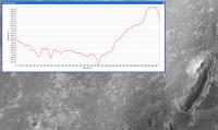
I've had a look at Cape York in my HiRISE DEM and I'm struggling to get much out of it topography-wise.
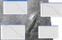
It looks like it's pretty low, ~6 m high (is that right?!), with something (albeit subtle) going on with those features around the edge. But to be honest, this area is really pushing the quality of my DEM: it's on a slope to the East, the MOLA shot points are scarce around here, and the surface texture is a bit dusty for pixel matching. So, combined with the vertical precision of my DEM being about 30 cm (I haven't checked), I'd only take this profile as a general guide. But it's still fun nonetheless! 3D views (with same health-warning) to follow. Pete |
|
|
|
|
|
|
Feb 10 2011, 05:28 PM
Post
#46
|
|
 Senior Member Group: Members Posts: 4247 Joined: 17-January 05 Member No.: 152 |
This is great - thanks Pete. Have you tested your calculations on a known target, like Santa Maria or Victoria and gotten reasonable numbers?
How easy is it to do more profiles? Is it feasible to do several cutting right across Cape York so we can see if the results are consistent? Anyway, such a short Cape York would certainly explain why we haven't spotted it yet. |
|
|
|
|
Feb 10 2011, 06:18 PM
Post
#47
|
|
|
Member Group: Members Posts: 808 Joined: 10-October 06 From: Maynard Mass USA Member No.: 1241 |
Pete., your Hirise DEM profile of Cape York is very snazzy! Thank you. I agree that the cape is kind of
short compared to what the overhead shot 'implies' (and the fact the we haven't seen it yet!) -------------------- CLA CLL
|
|
|
|
|
Feb 11 2011, 01:55 AM
Post
#48
|
|
 Member Group: Members Posts: 399 Joined: 28-August 07 From: San Francisco Member No.: 3511 |
So Cape York appears to be quite a bit inside Endeavor's "rim slope", I wonder when it will come into view, as sudden as Santa Maria ?...
-------------------- 'She drove until the wheels fell off...'
|
|
|
|
|
Feb 11 2011, 02:38 PM
Post
#49
|
|||
|
Junior Member Group: Members Posts: 59 Joined: 18-July 07 From: London, UK Member No.: 2873 |
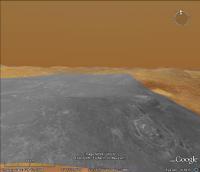
Let's see if we can get anything else out of my DEM around Cape York.
I follow the standard USGS way of making these DEMs, so I'm happy with the method, it's just that the results can vary from place to place. I haven't made one around Victoria because, well, it had already been done, and Santa Maria was just off this stereo pair. But Doug and I had some success with a DEM of the pathfinder landing site (http://www.youtube.com/watch?v=uE_Ih0hgnlw), and I'm churning these out for my science at the moment and they match up well with MOLA, CTX, HRSC data. I guess Cape York is actually a nice test! Profiles are no problem, but they're all pretty similar - the local slope into Endeavour just drowns most of the Cape York signal. That could be correct, or it could just be affecting the way that the DEM came out.
Here's a 3D perspective of Cape York, with a crazy x7 vertical exaggeration.
Looks pretty, but I wouldn't bet the house on it! Pete |
||
|
|
|
||
|
Feb 11 2011, 02:47 PM
Post
#50
|
|||
|
Junior Member Group: Members Posts: 59 Joined: 18-July 07 From: London, UK Member No.: 2873 |
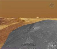
And while I'm filling up the place with images, I had a look at the visibility of Cape York from where Oppy might enter my DEM area.
First up a CTX base DEM with Oppy (green dot) just inside my HiRISE area. It shows up the relative depth of Endeavour compared to the really flat plains.
Then a visibility map (viewshed) of the raw unfiltered (hence noise) 1 m DEM from Oppy at the green dot. Cape York is not visibile as we'd expect.
I tried one the other way around, from the highest point at Cape York and basically you can only really see into the crater. So I guess if I'm right we won't see Cape York until we're right on it, but I'd be happy to be wrong. Pete |
||
|
|
|
||
|
Feb 11 2011, 03:03 PM
Post
#51
|
|
|
Senior Member Group: Admin Posts: 4763 Joined: 15-March 05 From: Glendale, AZ Member No.: 197 |
I joked previously that maybe Cape York is nothing more than a stain on the ground. It looks like I wasn't far off.
-------------------- If Occam had heard my theory, things would be very different now.
|
|
|
|
|
Feb 11 2011, 03:23 PM
Post
#52
|
||
|
Senior Member Group: Members Posts: 4247 Joined: 17-January 05 Member No.: 152 |
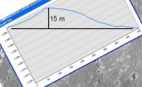
Thanks again, Pete. Those profiles certainly look consistent with each other. Subtracting off the overall slope, the tallest section (blue) gives around 15 metres height, which is starting to sound reasonable:
|
|
|
|
|
|
|
Feb 12 2011, 12:09 PM
Post
#53
|
|
|
Senior Member Group: Members Posts: 1088 Joined: 19-February 05 From: Close to Meudon Observatory in France Member No.: 172 |
QUOTE (fredk @ Feb 11 2011, 04:23 PM) Thanks again, Pete. Those profiles certainly look consistent with each other. Subtracting off the overall slope, the tallest section (blue) gives around 15 metres height, which is starting to sound reasonable: ... Meaning Cape York is well "climbable" by Oppy to get a better view (and to get a nice panorama) from its top : Endeavour's far rim and the other capes should give us a gorgeous view. Like many, I'm drooling over this upcoming view. Yum-Yum ! ... a "Yum-Yum" Pan. Bon Appetit ! (besides, it's lunch time right now in France)
|
|
|
|
|
Feb 12 2011, 03:53 PM
Post
#54
|
|
|
Member Group: Members Posts: 530 Joined: 21-March 06 From: Canada Member No.: 721 |
Looking at that 3D view, Cape York seems less like a hill to climb, and more like a ledge to drive out onto. I am so looking forward to arrival day. I almost wish I could fast forward to that event. Except that would probably mean winter is just starting again, and I am really, really tired of winter right now.
|
|
|
|
|
Feb 12 2011, 08:43 PM
Post
#55
|
|
|
Senior Member Group: Members Posts: 2921 Joined: 14-February 06 From: Very close to the Pyrénées Mountains (France) Member No.: 682 |
QUOTE (BrianL @ Feb 12 2011, 04:53 PM) Looking at that 3D view, Cape York seems less like a hill to climb, and more like a ledge to drive out onto. I am so looking forward to arrival day. I almost wish I could fast forward to that event. Except that would probably mean winter is just starting again, and I am really, really tired of winter right now. What are you talking about? Arrival time will be by Easter  
-------------------- |
|
|
|
|
Feb 12 2011, 11:05 PM
Post
#56
|
|
|
Senior Member Group: Members Posts: 1044 Joined: 17-February 09 Member No.: 4605 |
QUOTE (fredk @ Feb 11 2011, 03:23 PM) Thanks again, Pete. Those profiles certainly look consistent with each other. Subtracting off the overall slope, the tallest section (blue) gives around 15 metres height, which is starting to sound reasonable: Fred, I'm not sure I follow your logic here. Wouldn't a line of best fit along the plains approach section of the plot give the baseline to estimate the height of Cape York above the plain? I make the maximum height of the blue plot to be around three to four metres? |
|
|
|
|
Feb 13 2011, 03:38 AM
Post
#57
|
|
|
Senior Member Group: Members Posts: 4247 Joined: 17-January 05 Member No.: 152 |
You might be right about that, but I think we'd need to see how the profiles look farther out to know for sure where the plains "start". And as others have said, if that overall slope is right, this isn't a hill, it's more like a ledge to drive out on.
|
|
|
|
|
Feb 13 2011, 07:31 AM
Post
#58
|
|
|
The Poet Dude Group: Moderator Posts: 5551 Joined: 15-March 04 From: Kendal, Cumbria, UK Member No.: 60 |
Ok... trying to get my head around this... We're now thinking that Cape York isn't so much a "hill" as a kind of a "ledge" or platform sticking out from the inner slope of Endeavour...? Does that mean the hills that curve around the southern edge of the crater are the same? This is fascinating...
On another note, it was pleasing to find a LOT of interest in the MER mission last night when I gave an Outreach talk out at a little village just outside Kendal. "Mature" crowd, shall we say, general level of interest in science, but still, the ones who were aware that there are rovers on Mars were fascinated by them, and very impressed by what they've achieved. So say we all. -------------------- |
|
|
|
|
Feb 13 2011, 08:15 AM
Post
#59
|
|
|
Senior Member Group: Members Posts: 1044 Joined: 17-February 09 Member No.: 4605 |
The perennial problem with visual representations using axis with the same metric but different scales is the gut reaction 'gee that's steep'. It isn't a particularly steep gradient and rather than a ledge overlooking a chasm it is more of a low ridge with a (roughly) ten degree slope into the crater.
|
|
|
|
|
Feb 13 2011, 08:18 AM
Post
#60
|
|
|
The Poet Dude Group: Moderator Posts: 5551 Joined: 15-March 04 From: Kendal, Cumbria, UK Member No.: 60 |
Gotcha, thanks.
Still... hill... ledge... island... ledge... I need more tea. -------------------- |
|
|
|
|
Feb 13 2011, 08:37 AM
Post
#61
|
|
 Senior Member Group: Members Posts: 2228 Joined: 1-December 04 From: Marble Falls, Texas, USA Member No.: 116 |
That's right, Stu. The profiles in pgridrods's first image in his post above show it very nicely, even if the vertical and horizontal scales are not identical. Those profiles are essentially showing that Opportunity will not really need to climb up to get on top of Cape York. The idea to take away from this whole discussion is that Opportunity should be able to drive right over the top of Cape York with little trouble, unless boulders or loose sand block the way. The steepest slopes are on the back side of the Cape, and those apparently average 7-9 degrees.
Regarding the hills to the south, his topo maps posted above and earlier in another thread show them to have much more significant topography. -------------------- ...Tom
I'm not a Space Fan, I'm a Space Exploration Enthusiast. |
|
|
|
|
Feb 13 2011, 08:43 AM
Post
#62
|
||||
|
The Poet Dude Group: Moderator Posts: 5551 Joined: 15-March 04 From: Kendal, Cumbria, UK Member No.: 60 |
Thanks cosmic; I had read those posts... I was just recapping whilst virtually banging my head against my computer screen!
 I've just been
When you look at it more closely it looks like material flowed and rolled over Cape York from the west, doesn't it..?
-------------------- |
|||
|
|
|
|||
|
Feb 13 2011, 09:55 AM
Post
#63
|
|
|
Senior Member Group: Members Posts: 1044 Joined: 17-February 09 Member No.: 4605 |
Stu. I see what you mean. The NW rim has been eroded flat and the Meridiani sulphate sediments have flowed into the crater. Flowed tends to imply fluvial action but that terrace around Cape York does remind me of a shallow shoreline, sandbar rip channel system. Vikingmars "Dagger Valley" at the North end fits that scenario as a rip outflow channel. Cape York may be topography challenged but it is a fascinating destination.
|
|
|
|
|
Feb 13 2011, 12:46 PM
Post
#64
|
|
|
Senior Member Group: Members Posts: 3516 Joined: 4-November 05 From: North Wales Member No.: 542 |
Stu - or anyone handy with Google Mars - can you identify the hills on the horizon behind Cape York in your two lower views?
|
|
|
|
|
Feb 13 2011, 01:40 PM
Post
#65
|
||
|
The Poet Dude Group: Moderator Posts: 5551 Joined: 15-March 04 From: Kendal, Cumbria, UK Member No.: 60 |
Wider angle view...
Remember, tho, that everything is vertically stretched x3 -------------------- |
|
|
|
|
|
|
Feb 13 2011, 05:20 PM
Post
#66
|
|
|
Senior Member Group: Members Posts: 2228 Joined: 1-December 04 From: Marble Falls, Texas, USA Member No.: 116 |
You have to be very careful when looking at elevations using Google Mars. As I and others have pointed out, most of the topographic information used in Google mars is based on the MOLA coverage, which is not uniform, and typically not very closely spaced. Large stretches of Endeavor's rim were not sampled at all by MOLA shot points, so elevation maps derived from them do not display accurate elevations where topography is changing rapidly between MOLA lines and sample points. Emily posted a very nice kml file that will display those shot points in Google Mars. I think it was in the Distant Vistas thread.
One area of Mars that has higher frequency elevation coverage in Google Mars is Victoria Crater. That area has been populated with a digital elevation model based on more closely sampled points, probably based on a HiRise stereo pair. If you look at Victoria Crater in Google Mars you will see much more topographic detail than most anywhere else. -------------------- ...Tom
I'm not a Space Fan, I'm a Space Exploration Enthusiast. |
|
|
|
|
Feb 13 2011, 05:24 PM
Post
#67
|
|
|
The Poet Dude Group: Moderator Posts: 5551 Joined: 15-March 04 From: Kendal, Cumbria, UK Member No.: 60 |
Oh I agree, absolutely. I don't rely on GM, good as it is, for anything. But it is useful for giving a 'general impression' I'm sure you'll agree.
-------------------- |
|
|
|
|
Feb 13 2011, 06:09 PM
Post
#68
|
|
|
Senior Member Group: Members Posts: 3516 Joined: 4-November 05 From: North Wales Member No.: 542 |
QUOTE (Stu @ Feb 13 2011, 01:40 PM) Wider angle view... Thanks. So, am I right in thinking that's part of the Miyamoto rim in the background? (Sorry, OT I know.) |
|
|
|
|
Feb 14 2011, 03:28 AM
Post
#69
|
|
 Administrator Group: Admin Posts: 5172 Joined: 4-August 05 From: Pasadena, CA, USA, Earth Member No.: 454 |
I'd like to remind those of you engaging in this discussion of this post in which I brought all of the available MOLA ground tracks into Google Mars. You can see that all the ground tracks completely miss the entire western rim of Endeavour, so the MOLA data simply doesn't record the elevation of the rim. It's not in the data at all. It would be a much more productive exercise to do photoclinometry or develop a DEM from stereo imaging, as pgrindrod is trying to do...
-------------------- My website - My Patreon - @elakdawalla on Twitter - Please support unmannedspaceflight.com by donating here.
|
|
|
|
|
Feb 14 2011, 06:40 AM
Post
#70
|
|
|
The Poet Dude Group: Moderator Posts: 5551 Joined: 15-March 04 From: Kendal, Cumbria, UK Member No.: 60 |
Oh, heck, we were just having a bit of fun speculating.
But ok, I'll go tidy my room...
-------------------- |
|
|
|
|
Feb 14 2011, 06:49 AM
Post
#71
|
|
|
Senior Member Group: Admin Posts: 4763 Joined: 15-March 05 From: Glendale, AZ Member No.: 197 |
QUOTE (Stu @ Feb 13 2011, 10:40 PM) But ok, I'll go tidy my room... ... and while you are up there write out 100 times THERE IS NO MOLA DATA FOR THE RIM OF ENDEAVOR CRATER or there'll be no wandering around that castle of yours in the dark this evening, young man. -------------------- If Occam had heard my theory, things would be very different now.
|
|
|
|
|
Feb 15 2011, 05:30 PM
Post
#72
|
||
|
Junior Member Group: Members Posts: 59 Joined: 18-July 07 From: London, UK Member No.: 2873 |
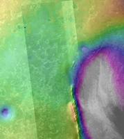
Just to add to the ways of getting across the geomorphology of Cape York, here's a red-blue analglyph of my Cape York DEM (plus contours).
And just in case that isn't overkill, here's a movie of the same area. You Tube animation - Cape York As you can tell, the resolution is turned way down in that movie (still managed to crash my computer several times!), and I don't yet have my pilot's licence. If my computer doesn't melt, expect a flurry of these things. Pete |
|
|
|
|
|
|
Feb 16 2011, 08:00 AM
Post
#73
|
|
|
Senior Member Group: Members Posts: 2228 Joined: 1-December 04 From: Marble Falls, Texas, USA Member No.: 116 |
Nice, Pete; but I think you got the red and cyan layers reversed. We can put our glasses on backwards to make it work, but if you are going to crank out a flurry of these things it might be best to reverse the colors.
 Thanks for all the good work, by the way. Thanks for all the good work, by the way. The animation was very effective.
-------------------- ...Tom
I'm not a Space Fan, I'm a Space Exploration Enthusiast. |
|
|
|
|
Feb 16 2011, 05:30 PM
Post
#74
|
|
 Senior Member Group: Moderator Posts: 3431 Joined: 11-August 04 From: USA Member No.: 98 |
Excellent movie and anaglyph. But yes, the red and cyan layers need to be reversed, or we need to wear our glasses upside-down.
|
|
|
|
|
Feb 16 2011, 07:59 PM
Post
#75
|
||
|
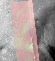
Member Group: Members Posts: 111 Joined: 14-March 05 From: Vastitas Borealis Member No.: 193 |
While we have seen very nice DEMs and a couple of lower-res anaglyphs of Cape York, I just thought an anaglyph in original size would be interesting for comparison. Only the north part was able to be included here within the maximum upload size, however I hope it's worth it.
Attached thumbnail(s)
|
|
|
|
|
|
|
Mar 31 2011, 03:48 PM
Post
#76
|
||
|
The Poet Dude Group: Moderator Posts: 5551 Joined: 15-March 04 From: Kendal, Cumbria, UK Member No.: 60 |
Now that we're officially "on our way", I thought it might be useful to compare the size of some of the major features and landmarks on Cape York with Oppy, so here you go... You'll see some orange "spots" on the landscape when you zoom in on it. The dark pixels in the centre of the dot shows the size of Oppy. Not easy to see, I know, so I'll post a higher resolution version on my blog later...
As usual, this is intended to be a rough guide, not a definitive one. Update: large version posted to my Twitpic account: http://twitpic.com/4fckki/full -------------------- |
|
|
|
|
|
|
Jul 19 2011, 06:19 PM
Post
#77
|
|
|
Junior Member Group: Members Posts: 53 Joined: 5-October 06 Member No.: 1227 |
While we are waiting to see Cape York, some Geology questions...
Cape York is lower than our present position (if it wasn't we would already see the peaks of Cape York above the horizon). So... Will Cape York be covered in sulfate deposits and blueberries? If 'Yes', then how come Cape York looks so distinctive from orbit with clear boundaries to the plains of Meridiani? If it was covered in sulfates and berries like everywhere else CY should appear as just a nondescript smooth bump. if 'No', then how can you have Cape York be free of sulfates and berries if it is lower elevation than our current location? If Meridiani was created by a pool of evaporating water, then CY should have even more deposits on it than we see where we are now since it is at a lower elevation. Basically, how can you have an 'island' that is below the sea bed!? Presumably CY has not subsided... Note that from space CY shows different materials (such as clays) which implies that it may not be covered with sulfates and blueberries. I am not sure what the answer is to this dilema. Does anyone have an explanation? One thought I had off the top of my head was that the sulfate deposits are from groundwater seepage (as has been proposed) with a geology sequence something like.. 1) Endevour impact 2) vast deposits of basaltic sands introduced (which we see are underneath the thin sulfate deposits here) 3) sand gets blown around and out of Endevour crater so that around the rim there are sand deposts that are higher than the actual Endevour impact crater rim (ie higher than CY) 4) sand is also blown off CY or never even accumulated on it 5) water seepage comes to the surface, depositing sulfates, but water does not seep 'up' CY because it is too far for water to seep upwards and/or because it is made of impermiable rock instead of basaltic sands 6) water seep stops, sulfates erode leaving blueberry lag depost (except on CY ) So, I think it will be very interesting to see if CY has blueberries/sulfates on it or not.... Thoughts?  -Ben- |
|
|
|
|
Jul 19 2011, 06:32 PM
Post
#78
|
|
|
Member Group: Members Posts: 362 Joined: 13-April 06 From: Malta Member No.: 741 |
I am no planetary geologist and therfore may not be knowledgable to answer such queries but I think that CY forms part of endeavour crater rim and thus represents material excavated from deeper layers on Mars which presumably contain the clays which predate the sulphates!
|
|
|
|
|
Jul 19 2011, 06:56 PM
Post
#79
|
|
|
Senior Member Group: Members Posts: 2173 Joined: 28-December 04 From: Florida, USA Member No.: 132 |
QUOTE (Julius @ Jul 19 2011, 01:32 PM) ... I think that CY forms part of endeavour crater rim and thus represents material excavated from deeper layers... Yes, but at one point the sulphate layers covered Cape York. They have been eroded away so I would expect to find blueberries that eroded out of the sulphate layers on Cape York but I would expect little left of the Sulphate layers themselves. As for why the Meridiani plains leading up to Cape York are higher, I guess it's just a matter of differential erosion rates due to the prevailing winds over the topography of the crater.
|
|
|
|
|
Jul 19 2011, 07:14 PM
Post
#80
|
|
|
Junior Member Group: Members Posts: 53 Joined: 5-October 06 Member No.: 1227 |
QUOTE (centsworth_II @ Jul 19 2011, 10:56 AM) Yes, but at one point the sulphate layers covered Cape York. They have been eroded away so I would expect to find blueberries that eroded out of the sulphate layers on Cape York but I would expect little left of the Sulphate layers themselves. This is quite plausable. In this case we should see a blueberry lag deposit directly on the clays (ie the sulfates are all gone in places). Blueberries over clays (and other CY rim materials) would look different than blueberries over sulfates & sands (which we are driving on) and would explain why CY is destinctive looking even though it is lower than the plains. |
|
|
|
|
Jul 19 2011, 08:22 PM
Post
#81
|
|
|
Member Group: Members Posts: 507 Joined: 10-September 08 Member No.: 4338 |
There has been no mention of a hematite signature from Cape York. Wouldn't a blueberry lag deposit produce such a signature?
|
|
|
|
|
Jul 19 2011, 09:15 PM
Post
#82
|
|
|
Solar System Cartographer Group: Members Posts: 10166 Joined: 5-April 05 From: Canada Member No.: 227 |
The CRISM composition data certainly don't seem to point to a blueberry layer on Cape York... but it's certainly legitimate to ask why not, if the whole area was covered with the plains material and it has eroded away. One possible explanation - blueberries were more common in some areas than in others, and this may be an area where they were not found to begin with. Test - look for blueberries in the plains immediately adjacent to the Cape.
Phil -------------------- ... because the Solar System ain't gonna map itself.
Also to be found posting similar content on https://mastodon.social/@PhilStooke Maps for download (free PD: https://upload.wikimedia.org/wikipedia/comm...Cartography.pdf NOTE: everything created by me which I post on UMSF is considered to be in the public domain (NOT CC, public domain) |
|
|
|
|
Jul 19 2011, 11:00 PM
Post
#83
|
|
|
Junior Member Group: Members Posts: 53 Joined: 5-October 06 Member No.: 1227 |
QUOTE (Phil Stooke @ Jul 19 2011, 01:15 PM) The CRISM composition data certainly don't seem to point to a blueberry layer on Cape York... If that is indeed the case, ie no berries/sulfates on CY while berries are [presumably] on the plains right around CY, then we have a head scratcher here and this might point more towards a groundwater source of the sulfate/hematite instead of an evaporated body of water (which would have had to have covered CY since CY is lower than the surrounding plains) as I proposed in my original post. Note: I am not a Geologist, but my dad is... :-) -Ben- |
|
|
|
|
Jul 19 2011, 11:20 PM
Post
#84
|
|
|
Member Group: Members Posts: 507 Joined: 10-September 08 Member No.: 4338 |
QUOTE (bgarlick @ Jul 19 2011, 04:00 PM) (which would have had to have covered CY since CY is lower than the surrounding plains) That might not follow. Flood waters pouring over a cliff will take the path of least resistance, and will avoid locally higher obstacles. It is only if the entire area was submerged that CY would necessarily have been covered. |
|
|
|
|
Jul 19 2011, 11:58 PM
Post
#85
|
|
|
Senior Member Group: Members Posts: 4247 Joined: 17-January 05 Member No.: 152 |
QUOTE (Phil Stooke @ Jul 19 2011, 09:15 PM) it's certainly legitimate to ask why not, if the whole area was covered with the plains material and it has eroded away Perhaps the berries rolled downhill into Endeavour, assisted by winds?Moderators: perhaps this discussion should be moved to the "Geomorphology of Cape York" thread? |
|
|
|
|
Jul 20 2011, 12:34 AM
Post
#86
|
|
|
Senior Member Group: Members Posts: 1044 Joined: 17-February 09 Member No.: 4605 |
The topography inside Endeavour would seem to indicate that the sediments flowed into the crater from the NW. The contours also seem to indicate a slightly steeper channel just to the south of CY. It is pretty clear that the blueberries formed within the sediments and whether there was just groundwater or whether there was a surface water overlay would seem immaterial. Low profile notwithstanding the feature is fascinating, but concentrating on the geomorphology of Cape York in isolation rather than standing back and considering it in the context of Endeavour Crater as a whole could be a bit limiting.
|
|
|
|
|
Jul 20 2011, 01:23 AM
Post
#87
|
|
 Member Group: Members Posts: 714 Joined: 3-January 08 Member No.: 3995 |
.
|
|
|
|
|
Jul 20 2011, 03:32 PM
Post
#88
|
||
|
Senior Member Group: Members Posts: 2173 Joined: 28-December 04 From: Florida, USA Member No.: 132 |
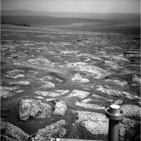
QUOTE (Phil Stooke @ Jul 19 2011, 05:15 PM) The CRISM composition data certainly don't seem to point to a blueberry layer on Cape York... ...Test - look for blueberries in the plains immediately adjacent to the Cape. This Pancam from sol 2658, about 1200 meters from Cape York, shows plenty of berries.
Does CRISM really show no hematite signal from Cape York, or is it just that that is not where the focus of attention is at? Phyllosilicate and hydrated sulphates are the focus, but does that mean the hematite is not there or just not being talked about? I think I will be more surprised to see few berries on Cape York than many. Just because I think The Cape was covered by the same berry containing layers that eroded away and left berries over the rest of Oppy's route. But maybe berry forming layers never did extend over Cape York. It will be interesting to see. |
|
|
|
|
|
|
Jul 20 2011, 03:59 PM
Post
#89
|
||
|
Senior Member Group: Members Posts: 2173 Joined: 28-December 04 From: Florida, USA Member No.: 132 |
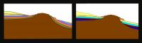
QUOTE (Gladstoner @ Jul 19 2011, 09:23 PM) Two interpretations of the terraces of Cape York: I hope you don't mind my fooling with your diagrams to better reflect the elevation between Cape York and the adjacent plains. (I'm sure Phil would do it if he had the time. )
|
|
|
|
|
|
|
Jul 20 2011, 06:44 PM
Post
#90
|
|
|
Member Group: Members Posts: 714 Joined: 3-January 08 Member No.: 3995 |
.
|
|
|
|
|
Jul 21 2011, 12:12 AM
Post
#91
|
|
|
Member Group: Members Posts: 714 Joined: 3-January 08 Member No.: 3995 |
.
|
|
|
|
|
Jul 21 2011, 01:05 AM
Post
#92
|
|
 Senior Member Group: Moderator Posts: 2785 Joined: 10-November 06 From: Pasadena, CA Member No.: 1345 |
I think I like your very first diagram the best (post 87 here). It explains the similar unit at the margin surrounding the central material of the ancient rim.
I'm not sure how I see that the interior layers could get bent to follow the crater interior. The initial whack should've gouged a big hole, and any layers that formed afterwards should have been dropped in parallel and flat. Any tilting after that would be uniform across the region...and you should see that as a difference in remnant rim heights. -------------------- Some higher resolution images available at my photostream: http://www.flickr.com/photos/31678681@N07/
|
|
|
|
|
Jul 21 2011, 01:37 AM
Post
#93
|
|
|
Member Group: Members Posts: 714 Joined: 3-January 08 Member No.: 3995 |
.
|
|
|
|
|
Aug 9 2011, 12:48 AM
Post
#94
|
|
|
Member Group: Members Posts: 714 Joined: 3-January 08 Member No.: 3995 |
.
|
|
|
|
|
Aug 9 2011, 01:05 AM
Post
#95
|
|
|
Senior Member Group: Moderator Posts: 2785 Joined: 10-November 06 From: Pasadena, CA Member No.: 1345 |
I'm not sure, but I think the uplifted rims of Endeavour were subjected to erosion and probably made a local mantling deposit at the base of the rim crests. Then additional materials were laid on top of that too. Then it was exhumed as you've described in your drawing.
(So take the drawing you did on June 18, then add a layer on top that then gets exhumed.) -------------------- Some higher resolution images available at my photostream: http://www.flickr.com/photos/31678681@N07/
|
|
|
|
|
Aug 9 2011, 01:16 AM
Post
#96
|
|
|
Member Group: Members Posts: 714 Joined: 3-January 08 Member No.: 3995 |
.
|
|
|
|
|
Aug 9 2011, 01:16 AM
Post
#97
|
|
|
Senior Member Group: Members Posts: 2173 Joined: 28-December 04 From: Florida, USA Member No.: 132 |
QUOTE (Gladstoner @ Aug 8 2011, 07:48 PM) ....Over time, these sedimentary rocks are eroded and covered with ejecta (made up of the same rock)... I'm not too sure about the ejecta layer you talk about. Over Opportunity's route, every time rock is exposed it appears to be a pavement of the originally deposited layers, not a bed of ejecta. The only significant ejecta seen is around some of the fresher craters and that is sparsely spread around the crater, not forming a layer. I don't think the sulphate rocks are durable enough to build up an ejecta layer. The only layer build up on the surface of Meridiani seems to be dust, sand and berries.
|
|
|
|
|
Aug 9 2011, 04:35 AM
Post
#98
|
|
|
Senior Member Group: Members Posts: 2228 Joined: 1-December 04 From: Marble Falls, Texas, USA Member No.: 116 |
centsworth_II: There was an ejecta layer at Victoria. There's not a continuous deposit across Meridiani as the drawing suggests, but at Victoria we drove over the planed surface of the ejecta blanket and also saw it in cross section on the capes. It should be drawn as a discontinuous layer. I agree that on many of the ancient craters the ejecta has been removed (Erebus, for example), but I think it is ok to show it schematically.
-------------------- ...Tom
I'm not a Space Fan, I'm a Space Exploration Enthusiast. |
|
|
|
|
Aug 9 2011, 06:33 AM
Post
#99
|
|||
|
Senior Member Group: Members Posts: 2173 Joined: 28-December 04 From: Florida, USA Member No.: 132 |
QUOTE (CosmicRocker @ Aug 8 2011, 11:35 PM) ...There was an ejecta layer at Victoria. The Victoria ejecta was highly localized, as is any of the ejecta on Meridiani as I see it. I could have it wrong, but here's the way I see it:Ninety percent of the Meridiani that Opportunity has shown us is characterized by a fractured sulphate pavement covered by a thin ripple layer of sand. I think this sulphate pavement is unmoved since it was formed from wind deposited sediment layers, subsequently acted on by water. I don't think it is a bed of ejecta.
Just adjacent to Cape York, this sulphate pavement seems to be a little jumbled. But I still think it is essentially the original wind placed Meridiani layers, not redistributed ejecta. Of course, I could be wrong.
|
||
|
|
|
||
|
Aug 9 2011, 10:33 AM
Post
#100
|
|
|
Senior Member Group: Moderator Posts: 2785 Joined: 10-November 06 From: Pasadena, CA Member No.: 1345 |
So you are thinking that the Endeavour ejecta is buried deep below the "Meridiani wind deposited then aqueous-altered" layers and probably not well exposed?
Below the yellow and brown layers in Gladstoner's graphic (which I really like, BTW). (...Makes sense to me.) -------------------- Some higher resolution images available at my photostream: http://www.flickr.com/photos/31678681@N07/
|
|
|
|
|

|
Lo-Fi Version | Time is now: 23rd May 2024 - 07:12 PM |
|
RULES AND GUIDELINES Please read the Forum Rules and Guidelines before posting. IMAGE COPYRIGHT |
OPINIONS AND MODERATION Opinions expressed on UnmannedSpaceflight.com are those of the individual posters and do not necessarily reflect the opinions of UnmannedSpaceflight.com or The Planetary Society. The all-volunteer UnmannedSpaceflight.com moderation team is wholly independent of The Planetary Society. The Planetary Society has no influence over decisions made by the UnmannedSpaceflight.com moderators. |
SUPPORT THE FORUM Unmannedspaceflight.com is funded by the Planetary Society. Please consider supporting our work and many other projects by donating to the Society or becoming a member. |
|