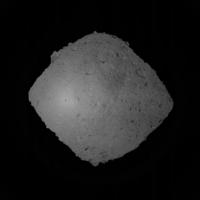
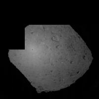
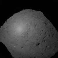
MASCOT landing on Ryugu, 3 October 2018 |

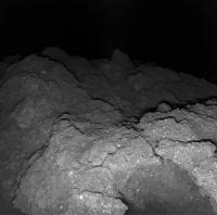
  |
MASCOT landing on Ryugu, 3 October 2018 |
 Oct 2 2018, 04:07 AM Oct 2 2018, 04:07 AM
Post
#1
|
|
 Senior Member  Group: Members Posts: 1431 Joined: 26-July 08 Member No.: 4270 |
The Japanese Hayabusa 2 twitter account reports that the spacecraft has begun descending toward Ryugu in preparation to deploy the MASCOT lander. Nothing on the English twitter as of the time of this post.
https://twitter.com/haya2_jaxa/status/1046965970466746369 -------------------- -- Hungry4info (Sirius_Alpha)
|
 |
 
|
|
Oct 2 2018, 06:00 AM
Post
#2
|
|
|
Newbie Group: Members Posts: 14 Joined: 30-September 14 Member No.: 7269 |
QUOTE (Hungry4info @ Oct 2 2018, 01:07 PM)  The Japanese Hayabusa 2 twitter account reports that the spacecraft has begun descending toward Ryugu in preparation to deploy the MASCOT lander. Nothing on the English twitter as of the time of this post. https://twitter.com/haya2_jaxa/status/1046965970466746369 English twitter account of HAYABUSA 2. https://twitter.com/haya2e_jaxa |
|
|
|
|
Oct 2 2018, 06:12 AM
Post
#3
|
|
|
Member Group: Members Posts: 282 Joined: 18-June 04 Member No.: 84 |
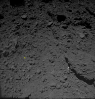
And the realtime images are back http://www.hayabusa2.jaxa.jp/en/galleries/onc/nav20181002/
|
|
|
|
| Guest_mcmcmc_* |
Oct 2 2018, 12:02 PM
Post
#4
|
|
|
Guests |
Follow #Hayabusa2 approach to #Ryugu for #MASCOT delivery in realtime!
https://programmi.000webhostapp.com/hayabus.../simulator.html Altitude logs: http://win98.altervista.org/hayabusa2/simu...r/hayabusa2.txt https://programmi.000webhostapp.com/hayabus...r/ONC_A-log.txt
Attached thumbnail(s)
|
|
|
|
|
|
| Guest_mcmcmc_* |
Oct 2 2018, 03:39 PM
Post
#5
|
|
Guests |
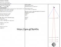
QUOTE (mcmcmc @ Oct 2 2018, 12:02 PM) Follow #Hayabusa2 approach to #Ryugu for #MASCOT delivery in realtime! https://programmi.000webhostapp.com/hayabus.../simulator.html Altitude logs: http://win98.altervista.org/hayabusa2/simu...r/hayabusa2.txt https://programmi.000webhostapp.com/hayabus...r/ONC_A-log.txt It appears from the simulator that from 1500 meters on, MINERVA rovers will start to be visible as 1 pixel bright objects in ONC-T. But we'll have to wait down to 400 meters to see them in ONC-W. ONC-T resolution is 10 times ONC-W, so 1 pixel in ONC-W is 10 pixel in ONC-T. |
|
|
|
|
Oct 3 2018, 12:19 AM
Post
#6
|
|
|
Merciless Robot Group: Admin Posts: 8784 Joined: 8-December 05 From: Los Angeles Member No.: 602 |
Spaceflight Now providing live coverage of MASCOT's landing here.
-------------------- A few will take this knowledge and use this power of a dream realized as a force for change, an impetus for further discovery to make less ancient dreams real.
|
|
|
|
|
Oct 3 2018, 01:39 AM
Post
#7
|
||||
|
Senior Member Group: Members Posts: 1431 Joined: 26-July 08 Member No.: 4270 |
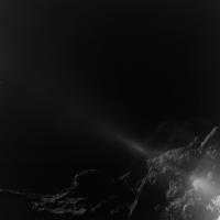
The last three frames show a persistent very bright dot on the surface. Possible MINERVA-II1 rover or protective drum?
Attached thumbnail(s)
-------------------- -- Hungry4info (Sirius_Alpha)
|
|||
|
|
|
|||
|
Oct 3 2018, 02:22 AM
Post
#8
|
|
|
Solar System Cartographer Group: Members Posts: 10166 Joined: 5-April 05 From: Canada Member No.: 227 |
Sorry, no - the Minerva area is on the other side of Ryugu. The white spot might be added to the images to indicate the descent target point (I'm only guessing) or it could be a naturally reflective object (there are several of them in earlier images). When somebody posted about the sizes of Minerva hardware in pixels, I think they were really only talking about image resolution, not whether the items would be visible, because they are not near the Masot landing area. For one thing, Mascot is targeted south of the equatorial ridge, Minerva was targeted north of it.
Phil -------------------- ... because the Solar System ain't gonna map itself.
Also to be found posting similar content on https://mastodon.social/@PhilStooke Maps for download (free PD: https://upload.wikimedia.org/wikipedia/comm...Cartography.pdf NOTE: everything created by me which I post on UMSF is considered to be in the public domain (NOT CC, public domain) |
|
|
|
|
Oct 3 2018, 03:04 AM
Post
#9
|
|||
 Member Group: Members Posts: 810 Joined: 3-June 04 From: Brittany, France Member No.: 79 |
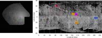
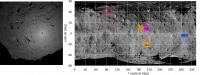
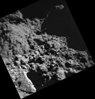
Identification of some rocks on photos taken by Hayabusa2 on 2018/10/03 at 00h41 and 01h12 UTC with estimated position of Hayabusa2 shadow
-------------------- |
||
|
|
|
||
|
Oct 3 2018, 03:15 AM
Post
#10
|
|
|
Merciless Robot Group: Admin Posts: 8784 Joined: 8-December 05 From: Los Angeles Member No.: 602 |
Separation confirmed per Spaceflight Now!
-------------------- A few will take this knowledge and use this power of a dream realized as a force for change, an impetus for further discovery to make less ancient dreams real.
|
|
|
|
|
Oct 3 2018, 03:25 AM
Post
#11
|
|
|
Forum Contributor Group: Members Posts: 1372 Joined: 8-February 04 From: North East Florida, USA. Member No.: 11 |
QUOTE (nprev @ Oct 3 2018, 04:15 AM) Separation confirmed per Spaceflight Now! Tweet confirms it. |
|
|
|
|
Oct 3 2018, 04:15 AM
Post
#12
|
||
|
Member Group: Members Posts: 810 Joined: 3-June 04 From: Brittany, France Member No.: 79 |
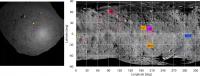
Identification of rocks on the picture taken at 1h46 UTC with shadow of Hayabusa 2 as a red cross. The shadow is probably shifted out of the map on the right since the map is missing a vertical band of latitude on 340° and 360°.
-------------------- |
|
|
|
|
|
| Guest_mcmcmc_* |
Oct 3 2018, 07:48 AM
Post
#13
|
|
Guests |
My recording of the delivery operations based on JAXA data (altitude in meters):
CODE Alt Generated at (GMT) Received At (GMT)) 101 2018-10-03 01:47:38 2018-10-03 02:05:47 47 2018-10-03 01:58:18 2018-10-03 02:16:27 - Mimimum altitude for 4 minutes 134 2018-10-03 02:02:02 2018-10-03 02:20:10 - Hayabusa 2 rises again. Full recording of descent: https://programmi.000webhostapp.com/hayabus...r/ONC_A-log.txt There are multiple lines for same data, but if you set up a "sparse data" chart in Excel, multiple lines will result is same point be drawn at same coordinate, so you'll just see one point. Press conference video (no links to press release yet): https://www.youtube.com/watch?v=O3WNAg5Zfvs It looks like national broadcasting company NHK created a simulated realtime video based on JAXA data during descent, but it was live, and I can't find the recording now: http://www.nhk.or.jp/special/space/#/english |
|
|
|
|
Oct 3 2018, 07:58 AM
Post
#14
|
|
|
Member Group: Members Posts: 102 Joined: 29-January 10 From: Poland Member No.: 5205 |
-------------------- Adam Hurcewicz from Poland
|
|
|
|
|
Oct 3 2018, 08:43 AM
Post
#15
|
||
|
Member Group: Members Posts: 810 Joined: 3-June 04 From: Brittany, France Member No.: 79 |
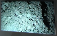
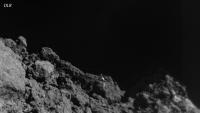
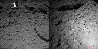
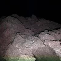
First image of MASCOT released, showing the landing site from an altitude of 40m:
-------------------- |
|
|
|
|
|
| Guest_mcmcmc_* |
Oct 3 2018, 08:48 AM
Post
#16
|
|
Guests |
|
|
|
|
|
Oct 3 2018, 08:48 AM
Post
#17
|
||
|
Member Group: Members Posts: 810 Joined: 3-June 04 From: Brittany, France Member No.: 79 |
JAXA just released the picture on its MASCOT lander feed: we even see the shadow of MASCOT

-------------------- |
|
|
|
|
|
| Guest_mcmcmc_* |
Oct 3 2018, 09:02 AM
Post
#18
|
|
|
Guests |
QUOTE (neo56 @ Oct 3 2018, 08:48 AM) JAXA just released the picture on its MASCOT lander feed: we even see the shadow of MASCOT
Released where? I found this image, but 180° rotated, on MASCOT2018 Twitter feed. |
|
|
|
|
|
|
Oct 3 2018, 11:33 AM
Post
#19
|
|
|
Senior Member Group: Members Posts: 2346 Joined: 7-December 12 Member No.: 6780 |
Press conference is continuing on YouTube.
There will be two more updates in 2 resp. 4 hours from now. |
|
|
|
|
Oct 3 2018, 11:36 AM
Post
#20
|
|
|
Senior Member Group: Members Posts: 2346 Joined: 7-December 12 Member No.: 6780 |
Mascot is fine after initial issues.
Performing night sequences, all instruments are working. |
|
|
|
|
Oct 3 2018, 01:46 PM
Post
#21
|
|
|
Senior Member Group: Members Posts: 2346 Joined: 7-December 12 Member No.: 6780 |
"short delay - stay tuned"
|
|
|
|
|
Oct 3 2018, 01:47 PM
Post
#22
|
|
|
Junior Member Group: Members Posts: 22 Joined: 15-November 14 Member No.: 7320 |
https://twitter.com/MASCOT2018/status/1047456139024261121
The team seems very confident in the hopping and uprighting mechanism. The found the first landung spot too dark and unstable, so commanded a first hop at the beginning of the first sol, to begin the science sequence at another location. Next press conference has a delay but should beginn soon. |
|
|
|
|
Oct 3 2018, 01:57 PM
Post
#23
|
|
|
Senior Member Group: Members Posts: 2346 Joined: 7-December 12 Member No.: 6780 |
live again...
|
|
|
|
|
Oct 3 2018, 02:01 PM
Post
#24
|
|
|
Senior Member Group: Members Posts: 2346 Joined: 7-December 12 Member No.: 6780 |
They had to make an important decision. Therefore the delay.
Spectrometer needs to be in contact with the surface. Radiometer will tell about thermal conductivity. Important for deflection of asteroids: What's the arrangement of grains? Magnetometer: Extremely sensitive, seeing separation, and operation of instruments. Magnetic field data to be cleaned from those instrument operation fields. They're going to be tired and will drink a beer this evening. Tomorrow, and until Friday, they'll take a look at the data. A first draft of evaluation will take a few more days of computation. But complete evaluaton will take years. |
|
|
|
|
Oct 3 2018, 02:19 PM
Post
#25
|
|
|
Junior Member Group: Members Posts: 22 Joined: 15-November 14 Member No.: 7320 |
Also interesting: Magentometer team decided to switch off the instrument to safe power, as the have enough data. Let's hope the second sol goes well. The estimate of 16 h battery time probably does not allow for surviving a third night.
|
|
|
|
| Guest_mcmcmc_* |
Oct 3 2018, 03:04 PM
Post
#26
|
|
Guests |
I read that expected battery life is just 16 hours and it's not rechargeable (no solar panels), and delivery occurred at around 02:17 GMT. So MASCOT mission should come to its end at around 18:17 GMT, 3 hours from now. |
|
|
|
|
Oct 3 2018, 03:10 PM
Post
#27
|
|
|
Junior Member Group: Members Posts: 22 Joined: 15-November 14 Member No.: 7320 |
Indeed. There will be another press conference in 25 min, maybe they tell us more about the expected life time of the battery. I think it is targeted to last at least two sols in the worst case. Also in the grphic from JAXA, end of mission (EOM) is during the third night. Let's hope for the best, and that the DLR team as uploaded a energy saving program for the third night, so MASCOT may have the chance to upload the data in the next morning, if it survives.
Otherwise the last hours in the night without contact are wasted. The technical reason is the mass constraint. With just 10 kg, solar panels and rechargables are just too heavy. Rechargables and do not have the energy density compared to non-rechargable batteries. Also, the location MASCOT finally settles was unknown, so no sun light guaranteed. And as we have seen with Philae, if the additional power from solar is required for the science goal, this just adds to the risk. |
|
|
|
|
Oct 3 2018, 07:18 PM
Post
#28
|
||
|
Member Group: Members Posts: 810 Joined: 3-June 04 From: Brittany, France Member No.: 79 |
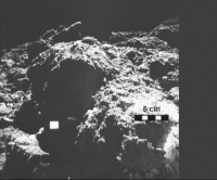
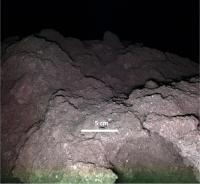
I added a scale to the first picture we have from MASCOT, and Buzz Aldrin to better figure out the scale (like Mystery Man of fredk
 ) )The altitude at which this picture was taken in 25 m and not 40 m as it was previously stated.
-------------------- |
|
|
|
|
|
|
Oct 3 2018, 08:49 PM
Post
#29
|
|
|
Junior Member Group: Members Posts: 22 Joined: 15-November 14 Member No.: 7320 |
Very nice, those are some big bolders. And again, shadows in the "right" direction makes it so much easier to grasp for my brain.
https://www.youtube.com/watch?v=wSoEapbchGA JAXA press conference for MASCOT with english translation. |
|
|
|
|
Oct 3 2018, 10:52 PM
Post
#30
|
|
|
Merciless Robot Group: Admin Posts: 8784 Joined: 8-December 05 From: Los Angeles Member No.: 602 |
QUOTE (neo56 @ Oct 3 2018, 11:18 AM) I added a scale to the first picture we have from MASCOT, and Buzz Aldrin to better figure out the scale (like Mystery Man of fredk )The official unit of all future photographic scale references on Ryugu is now the "Aldrin". 
-------------------- A few will take this knowledge and use this power of a dream realized as a force for change, an impetus for further discovery to make less ancient dreams real.
|
|
|
|
|
Oct 4 2018, 12:28 AM
Post
#31
|
|
 Member Group: Members Posts: 593 Joined: 20-April 05 Member No.: 279 |
QUOTE (nprev @ Oct 3 2018, 11:52 PM) The official unit of all future photographic scale references on Ryugu is now the "Aldrin". Remarkable to consider that some of those human-sized boulders 'weigh' less than a kilo. Aldrin could be chucking them all over the place. (...slowly). Andy |
|
|
|
|
Oct 4 2018, 07:00 AM
Post
#32
|
|
|
Junior Member Group: Members Posts: 87 Joined: 17-May 08 Member No.: 4114 |
JAXA announced that live navcam image updates are over for this operation: https://twitter.com/haya2e_jaxa/status/1047724464056782853
QUOTE [MASCOT] October 4 at 13:20 JST: The spacecraft is still hovering at an altitude of about 3km, but the real-time broadcast of the navigation images captured by the ONC-W1 has ended. Thank you for watching! http://www.hayabusa2.jaxa.jp/en/galleries/onc/nav20181002/
#AsteroidLanding Here's all the images assembled into an animation https://flic.kr/p/PyxrCm The 3km hover phase at the end gives a nice feel for the rotation |
|
|
|
| Guest_mcmcmc_* |
Oct 4 2018, 11:38 AM
Post
#33
|
|
Guests |
Mission finished. If accomplished... who knows?
https://twitter.com/MASCOT2018/status/1047806424334655488 |
|
|
|
|
Oct 4 2018, 12:58 PM
Post
#34
|
|
|
Junior Member Group: Members Posts: 57 Joined: 20-January 12 From: Florida Member No.: 6317 |
QUOTE (mcmcmc @ Oct 4 2018, 07:38 AM) Mission finished. If accomplished... who knows? https://twitter.com/MASCOT2018/status/1047806424334655488 The DLR boffins seem much slower in releasing images than their JAXA counterparts and less concerned with public relations generally. (The goofy first-person tweets do not count.) All that data has to have been transmitted from the surface already, since the batteries have died so perhaps waiting on board Hayabusa. |
|
|
|
|
Oct 4 2018, 01:16 PM
Post
#35
|
|
 Senior Member Group: Members Posts: 1729 Joined: 3-August 06 From: 43° 35' 53" N 1° 26' 35" E Member No.: 1004 |
QUOTE (Blue Sky @ Oct 4 2018, 02:58 PM) The DLR boffins seem much slower in releasing images than their JAXA counterparts and less concerned with public relations generally. remember Philae, Rosetta's OSIRIS etc. and don't hold your breath for new images. We have to hope for some embedded scientist to release all the images as someone did for Huygens. |
|
|
|
|
Oct 4 2018, 07:08 PM
Post
#36
|
|
|
Junior Member Group: Members Posts: 22 Joined: 15-November 14 Member No.: 7320 |
In the press conferences yesterday, it was said, that all data will be downloaded from Hayabusa2 on Friday. Considering, that we got updates nearly every 2 h yesterday from the leading members of the MASCOT team, who were surely occupied otherwise, I think the DLR already did a great job covering the event. Ok, compared to thier performance in this regard on other projects.
Also, JAXA has some nice live coverages, but only with the wide field camera. From all the other instruments, and the MINERVAs, too, the data release is not immediate. We have to remember, which agency does the mission and under what premise. I am not sure about JAXA, but thier main "audience" is Japanese. For Rosetta, ESA was bound by contracts to the very slow release of data that we see now. Maybe not suited for todays culutre, but it was fine at the time the mission was planned. Yes, NASA is very open, but that's how it sees its role in the USA. Concerning the DLR, the culture in Germany is not so much the US view of "tax-payers money, so show the results to the tax-payer", but more state funded research. So the obligation to publicly present the work is far less. This being said: Where are the images from MASCOT from the surface??
|
|
|
|
|
Oct 4 2018, 08:18 PM
Post
#37
|
|
|
Founder Group: Chairman Posts: 14432 Joined: 8-February 04 Member No.: 1 |
As a comparison - the camera on MASCOT ( MasCam ) is somewhat related to the CIVA cameras on Philae.
4 CIVA images were released to the public after Philae's landing The full CIVA data was finally released to the ESA PSA in August of this year. That's 13.5 years after the first data was collected by CIVA and 3 years after the end of Philae's mission Patience is going to be required. Lots of it. We have been thoroughly spoiled by MER, MSL, Cassini and New Horizons. It is quite apparent that other agencies do not consider that kind of image release policy to be the new normal. |
|
|
|
|
Oct 4 2018, 09:39 PM
Post
#38
|
|
|
Newbie Group: Members Posts: 7 Joined: 22-September 18 From: Bavaria Member No.: 8456 |
"Inside Information" from a participant of the IAC: There is going to be a press conference at the IAC tomorrow (Friday) at 6:30 UTC, so in about nine hours. But I haven't seen any announcements, tweets so far.
|
|
|
|
|
Oct 5 2018, 05:20 AM
Post
#39
|
|
|
Member Group: Members Posts: 239 Joined: 28-October 12 Member No.: 6732 |
It would be better if everyone would follow rule 2.6. Your comments will be deleted.
 Or does rule 2.6 apply only to NASA missions? Or does rule 2.6 apply only to NASA missions?  Edit: I see, Lex Sternia!
|
|
|
|
|
Oct 5 2018, 06:01 AM
Post
#40
|
|
|
Junior Member Group: Members Posts: 22 Joined: 15-November 14 Member No.: 7320 |
Don't think so, thanks for the reminder.
IAC live stream can be followed here: http://www.iafastro.org/iac-2018-live-streaming/ Unfortunately, it costs 20 . @Baywa: Are on the show and can tell us what will be presented? |
|
|
|
|
Oct 5 2018, 07:03 AM
Post
#41
|
|
|
Newbie Group: Members Posts: 7 Joined: 22-September 18 From: Bavaria Member No.: 8456 |
@Baywa: Are on the show and can tell us what will be presented?
[/quote] No, I'm not. But Elizabeth Tasker @girlandkat is tweeting. Have to hurry, breakfast! |
|
|
|
|
Oct 5 2018, 07:53 AM
Post
#42
|
|
|
Member Group: Members Posts: 470 Joined: 24-March 04 From: Finland Member No.: 63 |
DLR's site now has some images, click the side arrows to see all three images:
https://www.dlr.de/dlr/desktopdefault.aspx/...#/gallery/32253 -------------------- Antti Kuosmanen
|
|
|
|
|
Oct 5 2018, 07:58 AM
Post
#43
|
|
|
Member Group: Members Posts: 241 Joined: 16-May 06 From: Geneva, Switzerland Member No.: 773 |
Some previews on twitter by @davide_coco91 https://twitter.com/davide_coco91
Video of MASCOT leaving Hayabusa and picture of surface at hopping location number 2. |
|
|
|
|
Oct 5 2018, 08:03 AM
Post
#44
|
||
 Member Group: Members Posts: 238 Joined: 15-January 13 Member No.: 6842 |
Keep an eye on Twitter, hashtag #IAC2018
Here's a surface photo from MASCOT!
Cropped and colour-corrected from this tweet: http://twitter.com/davide_coco91/status/1048103752262193152 -------------------- Curiosity rover panoramas: http://www.facebook.com/CuriosityRoverPanoramas
My Photosynth panoramas: http://photosynth.net/userprofilepage.aspx...;content=Synths |
|
|
|
|
|
|
Oct 5 2018, 08:17 AM
Post
#45
|
||
|
Member Group: Members Posts: 436 Joined: 14-December 15 Member No.: 7860 |
a new picture from MASCOT - just above the surface of Ryugu
Attached thumbnail(s)
|
|
|
|
|
|
|
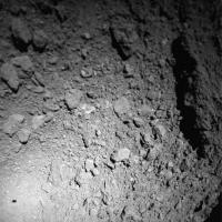
Oct 5 2018, 09:08 AM
Post
#46
|
||
|
Member Group: Members Posts: 436 Joined: 14-December 15 Member No.: 7860 |
QUOTE (akuo @ Oct 5 2018, 09:53 AM) DLR's site now has some images, click the side arrows to see all three images: https://www.dlr.de/dlr/desktopdefault.aspx/...#/gallery/32253
Attached thumbnail(s)
|
|
|
|
|
|
|
Oct 5 2018, 09:13 AM
Post
#47
|
|
|
Member Group: Members Posts: 436 Joined: 14-December 15 Member No.: 7860 |
These two pictures are from 10 - 20 (25) m above the surface, before the first landing of MASCOT
|
|
|
|
|
Oct 5 2018, 09:37 AM
Post
#48
|
|
|
Newbie Group: Members Posts: 14 Joined: 30-September 14 Member No.: 7269 |
|
|
|
|
|
Oct 5 2018, 01:08 PM
Post
#49
|
|
|
Newbie Group: Members Posts: 14 Joined: 30-September 14 Member No.: 7269 |
http://www.hayabusa2.jaxa.jp/en/topics/20181005e_MSC_ONC/
The small asteroid lander, MASCOT, that was developed in Germany and France, was successfully separated from the Hayabusa2 spacecraft on October 3 and delivered safely to the surface of Ryugu. After landing, MASCOT acquired scientific data on the asteroid surface, which was transmitted to the MASCOT team via the spacecraft. Scientific analysis of this data is expected to be performed by the MASCOT team from now onwards. From the Hayabusa2 spacecraft, we attempted to capture the separated MASCOT using the three optical navigation cameras (ONC-T, ONC-W1, ONC-W2). When the image data was received from the spacecraft, we could confirm that MASCOT appears in images photographed with the ONC-W1 and ONC-W2. |
|
|
|
|
Oct 5 2018, 01:13 PM
Post
#50
|
|
|
Senior Member Group: Members Posts: 2086 Joined: 13-February 10 From: Ontario Member No.: 5221 |
That first image is almost unreal, Yoichi, thanks for finding it for us non-Japanese speakers! Wow!
|
|
|
|
|
Oct 5 2018, 04:28 PM
Post
#51
|
|
|
Founder Group: Chairman Posts: 14432 Joined: 8-February 04 Member No.: 1 |
Was able to extract some 3D data from the three images from Hayabusa during MASCOT's decent
https://sketchfab.com/models/c7155bfcac774d...b4688709b9faca3 |
|
|
|
|
Oct 5 2018, 04:30 PM
Post
#52
|
|
 Administrator Group: Admin Posts: 5172 Joined: 4-August 05 From: Pasadena, CA, USA, Earth Member No.: 454 |
Anybody know the proper credit on MASCOT images?
-------------------- My website - My Patreon - @elakdawalla on Twitter - Please support unmannedspaceflight.com by donating here.
|
|
|
|
|
Oct 5 2018, 04:40 PM
Post
#53
|
|
|
Senior Member Group: Members Posts: 2086 Joined: 13-February 10 From: Ontario Member No.: 5221 |
QUOTE (elakdawalla @ Oct 5 2018, 11:30 AM) Anybody know the proper credit on MASCOT images? According to here (scroll to MASCOT instruments): https://www.dlr.de/dlr/en/desktopdefault.as...#/gallery/31165 "Institute of Planetary Research, DLR" |
|
|
|
|
Oct 5 2018, 04:48 PM
Post
#54
|
|
|
Administrator Group: Admin Posts: 5172 Joined: 4-August 05 From: Pasadena, CA, USA, Earth Member No.: 454 |
Thanks for the link, that's useful. I'm gonna go ahead and add JAXA and CNES in as well...
-------------------- My website - My Patreon - @elakdawalla on Twitter - Please support unmannedspaceflight.com by donating here.
|
|
|
|
|
Oct 5 2018, 04:58 PM
Post
#55
|
|
|
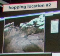
Junior Member Group: Members Posts: 57 Joined: 20-January 12 From: Florida Member No.: 6317 |
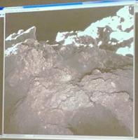
Still no information on scale, so it is hard to know what we are looking at. What I am interested in is the first picture, showing the DLR control room. A woman is in the left foreground looking at the projected information on the wall. In the left part of that information is an image of some rocky terrain that does not seem to be among the other pictures they have released.
|
|
|
|
|
Oct 5 2018, 05:48 PM
Post
#56
|
|
|
Newbie Group: Members Posts: 7 Joined: 22-September 18 From: Bavaria Member No.: 8456 |
QUOTE (elakdawalla @ Oct 5 2018, 06:30 PM) Anybody know the proper credit on MASCOT images? On the latest images from MASCOT it says Credit: MASCOT/DLR/JAXA see https://www.dlr.de/dlr/en/desktopdefault.as...#/gallery/32249 Click on "Information" |
|
|
|
|
Oct 5 2018, 08:34 PM
Post
#57
|
||
|
Member Group: Members Posts: 238 Joined: 15-January 13 Member No.: 6842 |
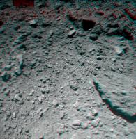
An attempted red-green stereo image using the frames from MASCOT descent:
Creadit: JAXA/University of Tokyo/Kochi University/Rikkyo University/Nagoya University/Chiba Institute of Technology/Meiji University/University of Aizu/AIST/Kakitsev 
-------------------- Curiosity rover panoramas: http://www.facebook.com/CuriosityRoverPanoramas
My Photosynth panoramas: http://photosynth.net/userprofilepage.aspx...;content=Synths |
|
|
|
|
|
|
Oct 5 2018, 08:36 PM
Post
#58
|
|||
|
Member Group: Members Posts: 810 Joined: 3-June 04 From: Brittany, France Member No.: 79 |
Hayabusa2 and MASCOT pictures of the same scene from a different point of view:
-------------------- |
||
|
|
|
||
|
Oct 5 2018, 11:30 PM
Post
#59
|
||
|
Senior Member Group: Members Posts: 1431 Joined: 26-July 08 Member No.: 4270 |
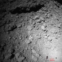
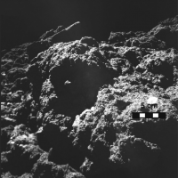
There's a much higher quality image of the "hopping location #2" pic from MASCOT on the DLR website. It's embedded into a margin smaller than the image, which shrinks it a bit, but if you open the image itself, you can see a lot more detail.
Attached thumbnail(s)
-------------------- -- Hungry4info (Sirius_Alpha)
|
|
|
|
|
|
|
Oct 5 2018, 11:40 PM
Post
#60
|
|
|
Member Group: Members Posts: 121 Joined: 26-June 04 From: Austria Member No.: 89 |
I see on the MASCOT pictures that one side is not focused..somewhat blurry ...is there any reason for this ?
My guess is, that it is not dejustet but if you land upright you have the nearer objects better in focus than the more far away and you not need a focusable lens assembly which adds some risk to the lander. Or is it really out of focus ? Rob |
|
|
|
|
Oct 6 2018, 01:15 AM
Post
#61
|
|
 Member Group: Members Posts: 290 Joined: 29-December 05 From: Ottawa, ON Member No.: 624 |
I was wondering about the same thing. Either the image sensor isn't aligned to the lens due to temperature shift or related stress, or, it's deliberately like that so when the spacecraft is on the surface, and righted, both the foreground and background will be in focus like a tilt shift camera where you change the angle of the negative to increase depth of field.
|
|
|
|
|
Oct 6 2018, 07:49 AM
Post
#62
|
||
|
Member Group: Members Posts: 810 Joined: 3-June 04 From: Brittany, France Member No.: 79 |
I aligned each 3 frames of the MASCOT animation in relation to Ryugu surface:
-------------------- |
|
|
|
|
|
|
Oct 6 2018, 03:27 PM
Post
#63
|
|
|
Senior Member Group: Members Posts: 2086 Joined: 13-February 10 From: Ontario Member No.: 5221 |
No new pictures, but some science results in this article: https://spaceflightnow.com/2018/10/05/masco...s-expectations/
QUOTE What weve learned so far from the pictures is it looks like the surface is more consolidated rocks overlaid by a thin layer of particulate material, Grott said.
|
|
|
|
|
Oct 11 2018, 07:01 PM
Post
#64
|
|
|
Junior Member Group: Members Posts: 52 Joined: 16-November 06 Member No.: 1364 |
QUOTE (Steve G @ Oct 6 2018, 02:15 AM) I was wondering about the same thing. Either the image sensor isn't aligned to the lens due to temperature shift or related stress, or, it's deliberately like that so when the spacecraft is on the surface, and righted, both the foreground and background will be in focus like a tilt shift camera where you change the angle of the negative to increase depth of field. It is deliberately like that. It's called the Scheimpflug principle. There's a press conference tomorrow with some new material. |
|
|
|
|
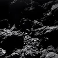
Oct 12 2018, 12:15 PM
Post
#65
|
|
|
Newbie Group: Members Posts: 14 Joined: 30-September 14 Member No.: 7269 |
https://www.dlr.de/dlr/presse/en/desktopdef...#/gallery/32338
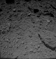
Numerous boulders, many rocks, no dust: MASCOT's zigzag course across the asteroid Ryugu 
|
|
|
|
|
Oct 13 2018, 03:35 PM
Post
#66
|
|
|
Senior Member Group: Members Posts: 2086 Joined: 13-February 10 From: Ontario Member No.: 5221 |
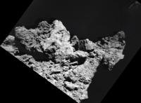
Finally surface images! Nice oblique view of the giant south pole boulder too! The top seems to be the only big smooth part of Ryugu....
And we have a name for the landing site: 'Alice's Wonderland' |
|
|
|
|
Oct 15 2018, 02:59 PM
Post
#67
|
|
|
Senior Member Group: Members Posts: 1583 Joined: 14-October 05 From: Vermont Member No.: 530 |
QUOTE (yoichi @ Oct 12 2018, 08:15 AM) https://www.dlr.de/dlr/presse/en/desktopdef...#/gallery/32338 Numerous boulders, many rocks, no dust: MASCOT's zigzag course across the asteroid Ryugu For those like me wondering about the "no dust" in the title, it's described only as "fine material" in the accompanying text. No dust? Makes you wonder if the dust gets cemented. |
|
|
|
|
Oct 15 2018, 07:21 PM
Post
#68
|
|
|
Solar System Cartographer Group: Members Posts: 10166 Joined: 5-April 05 From: Canada Member No.: 227 |
It's easy to make dust through micrometeorite impacts, and some at least should be retained. But cementing or consolidating it is much more difficult. More likely it's a sifting effect, where jostling by impacts causes large chunks to rise and small objects to fall into spaces between them. On Itokawa the same thing was seen except that in some low-lying areas the fine materal became concentrated in smooth patches. We don't see that here, maybe because Ryugu is more equidimensional.
-------------------- ... because the Solar System ain't gonna map itself.
Also to be found posting similar content on https://mastodon.social/@PhilStooke Maps for download (free PD: https://upload.wikimedia.org/wikipedia/comm...Cartography.pdf NOTE: everything created by me which I post on UMSF is considered to be in the public domain (NOT CC, public domain) |
|
|
|
|
Jan 30 2019, 11:10 PM
Post
#69
|
||
|
Senior Member Group: Members Posts: 1431 Joined: 26-July 08 Member No.: 4270 |
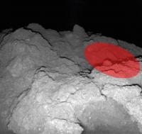
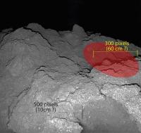
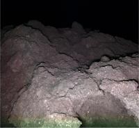
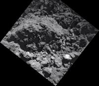
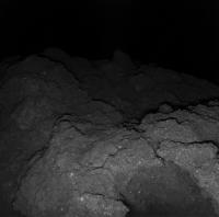
This abstract at the 50th LPSC has a new image from MASCOT, taken during local night with the red LED on. The red ellipse is labelled as the radiometer field of view. Is it possible to remove it from the image to try to restore the background image?
https://www.hou.usra.edu/meetings/lpsc2019/pdf/1267.pdf
Attached thumbnail(s)
-------------------- -- Hungry4info (Sirius_Alpha)
|
|
|
|
|
|
|
Jan 31 2019, 01:13 AM
Post
#70
|
||
|
Administrator Group: Admin Posts: 5172 Joined: 4-August 05 From: Pasadena, CA, USA, Earth Member No.: 454 |
Needs a little cosmetic work around the edges of the ellipse, but here's a quick and dirty version:
Attached thumbnail(s)
-------------------- My website - My Patreon - @elakdawalla on Twitter - Please support unmannedspaceflight.com by donating here.
|
|
|
|
|
|
|
Jan 31 2019, 03:54 AM
Post
#71
|
|
|
Forum Contributor Group: Members Posts: 1372 Joined: 8-February 04 From: North East Florida, USA. Member No.: 11 |
QUOTE (elakdawalla @ Jan 31 2019, 02:13 AM) Needs a little cosmetic work around the edges of the ellipse, but here's a quick and dirty version: Anyone know what the scale is we are looking at ? |
|
|
|
|
Jan 31 2019, 03:17 PM
Post
#72
|
|
|
Newbie Group: Members Posts: 7 Joined: 22-September 18 From: Bavaria Member No.: 8456 |
QUOTE (MahFL @ Jan 31 2019, 04:54 AM) Anyone know what the scale is we are looking at ? In the article it says " MARA observed a rock formation of approximately 60 cm diameter, which is shown in Fig. 1." Fig.1. being the attached picture. But I'm not quite sure: 60cm may also refer to the red ellipse.
|
|
|
|
|
Jan 31 2019, 11:54 PM
Post
#73
|
||
 Member Group: Members Posts: 714 Joined: 3-January 08 Member No.: 3995 |
QUOTE (elakdawalla @ Jan 30 2019, 07:13 PM) Needs a little cosmetic work around the edges of the ellipse, but here's a quick and dirty version: Cleaned up, with a bit of necessary artistic license:
|
|
|
|
|
|
|
Feb 1 2019, 07:21 AM
Post
#74
|
||
 Senior Member Group: Members Posts: 2173 Joined: 28-December 04 From: Florida, USA Member No.: 132 |
QUOTE (MahFL @ Jan 30 2019, 11:54 PM) Anyone know what the scale is we are looking at ?
If my math is right and the pixels on the image are accurate to the original, I get the 10 cm bar (in black) based on 500 pixels at 0.2mm per pixel at the bottom of the image as mentioned in the image caption. I get the 60cm bar (in yellow) based on 300 pixels at 2mm per pixel (rough estimation, based on 0.2mm per pixel at the bottom of the image and 3mm per pixel near the horizon as mentioned in the image caption). Disclaimer: I am not an accomplished image interpreter. |
|
|
|
|
|
|
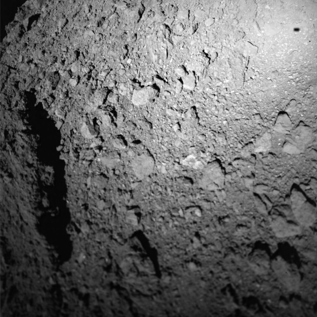
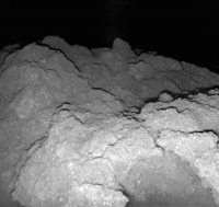
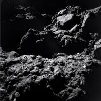
Jul 15 2019, 09:27 PM
Post
#75
|
|
|
Senior Member Group: Members Posts: 1431 Joined: 26-July 08 Member No.: 4270 |
"MASCOT confirms what scientists have long suspected
Small fragments of carbon-rich asteroids are too fragile to survive entry into Earths atmosphere" Press release: https://www.dlr.de/dlr/presse/en/desktopdef...x9fOby8qyxi5AWo Original paper: Low thermal conductivity boulder with high porosity identified on C-type asteroid (162173) Ryugu https://www.nature.com/articles/s41550-019-...rPquGwVWtmiCPak -------------------- -- Hungry4info (Sirius_Alpha)
|
|
|
|
|
Aug 25 2019, 03:28 AM
Post
#76
|
||||
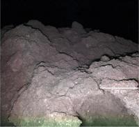
|
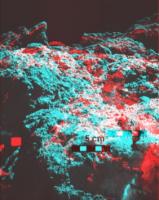
Senior Member Group: Members Posts: 1431 Joined: 26-July 08 Member No.: 4270 |
There are some images from MASCOT at the following website, showing the area that we have seen before, but at four different times of day.
https://mascot.cnes.fr/fr/les-premieres-pho...yugu-par-mascot At first I was having a hard time connecting surface features but then I realised that MASCOT moved a bit between the late morning and noon images. This is confirmed in the Science paper posted yesterday (23 August 2019). QUOTE On the morning of the third day, the lander slipped ~5 cm sideways by executing a mini-move to enable stereo imaging for photogrammetric analysis, reaching a third location (MP3) I've constructed a 3D anaglyph and a black-and-forth .gif that shows the move, and the 3D perspective of the surface. The 3D image is kinda crude, admittedly. (Edit: Added a cropped .gif that shows less, of course, but should help look less like a light-switch as that seems to mess with one's mind after a bit)
Attached thumbnail(s)
-------------------- -- Hungry4info (Sirius_Alpha)
|
|||
|
|
|
|||
|
Aug 25 2019, 04:10 AM
Post
#77
|
||
|
Senior Member Group: Members Posts: 1431 Joined: 26-July 08 Member No.: 4270 |
Similar in theme to my last post. This animation blinks between the Noon image and the Late Afternoon image, showing differences in illumination angle. It looks like the lander has slid a bit between these two images as well, and I'm pretty confident it is not an artifact of the changes in lighting angle.
Attached thumbnail(s)
-------------------- -- Hungry4info (Sirius_Alpha)
|
|
|
|
|
|
|
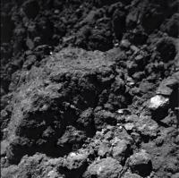
Aug 26 2019, 11:24 PM
Post
#78
|
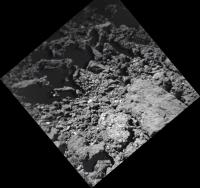
|||||||
|
Member Group: Members Posts: 436 Joined: 14-December 15 Member No.: 7860 |
Beautiful photos!
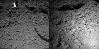
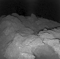
This article is also interesting (22 August 2019) with a handful of photos from MASCOT, including this famous picture, which we all waited for. I took out a few of them (Credit: MASCOT / DLR / JAXA). PS. In the article, informative descriptions are visible under the photos in the Fullscreen option
Attached thumbnail(s)
|
||||||
|
|
|
||||||
|
Aug 26 2019, 11:30 PM
Post
#79
|
|
|
Member Group: Members Posts: 436 Joined: 14-December 15 Member No.: 7860 |
QUOTE (Hungry4info @ Aug 25 2019, 06:10 AM) Similar in theme to my last post. This animation blinks between the Noon image and the Late Afternoon image, showing differences in illumination angle. It looks like the lander has slid a bit between these two images as well, and I'm pretty confident it is not an artifact of the changes in lighting angle. I think that in microgravity on Ryugu, every smallest movement of scientific instruments inside the lander generates small corps shifts („... at 10 kilograms, MASCOT experienced a gravitational force of 0.17 grams on Ryugu...”) |
|
|
|
|
Aug 26 2019, 11:54 PM
Post
#80
|
|
|
Member Group: Members Posts: 436 Joined: 14-December 15 Member No.: 7860 |
In the cited article there is also an interesting reference to the discussion about dust (or rather its lack) on the surface of Ryugu, which I initiated on this forum a few months ago:
"...Ralf Jaumann and his team were particularly surprised by the lack of dust: "Ryugu's entire surface is littered with boulders, but we have not discovered dust anywhere. It should be present, due to the bombardment of the asteroid by micrometeorites over billions of years, and their weathering effect. However, as the asteroid has very low gravity – only one-sixtieth of that experienced on Earth’s surface – the dust has either disappeared into cavities on the asteroid or has escaped into space. This gives an indication of the complex geophysical processes occurring on the surface of this small asteroid...” |
|
|
|
|
Aug 27 2019, 12:08 AM
Post
#81
|
|
|
Member Group: Members Posts: 436 Joined: 14-December 15 Member No.: 7860 |
And another quote from the same article is particularly interesting for metorite collectors:
"...Until now, the MASCOT scientists believed that Ryugu was similar to two meteorites that fell to Earth in 1969 in Allende, Mexico, and Murchison, Australia. However, those meteorites barely contain bright particles, probably due to the weathering effect of water in the crystal grid of these minerals. The bright inclusions that have now been observed have led the scientists to conclude that Ryugu's cauliflower-like rocks bear greater similarities to meteorites from Tagish Lake. On 18 January 2000, hundreds of small meteorites rained down on Earth following the explosion of a large fireball over Canada, and numerous fragments were found on the ice of the frozen lake. These are very rare stony meteorites from what is referred to as the CI chondrite class. The C stands for the chemical element carbon, and the I for the similarity with the Ivuna meteorite found in Tanzania. They are among the oldest and most primitive components of the Solar System, remnants of the first solid bodies to be formed in the primordial solar nebula..." |
|
|
|
|
Aug 27 2019, 12:46 AM
Post
#82
|
||
|
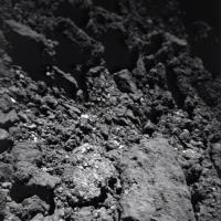
Member Group: Members Posts: 436 Joined: 14-December 15 Member No.: 7860 |
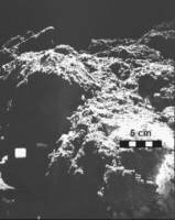
I added the scale bar according to the original description under the color picture
Attached thumbnail(s)
|
|
|
|
|
|
|
Aug 27 2019, 01:05 AM
Post
#83
|
|||||
|
Member Group: Members Posts: 436 Joined: 14-December 15 Member No.: 7860 |
A little play with a changing perspective in this crazy but beautiful world
Attached thumbnail(s)
|
||||
|
|
|
||||
|
Aug 27 2019, 01:23 AM
Post
#84
|
|
|
Member Group: Members Posts: 436 Joined: 14-December 15 Member No.: 7860 |
QUOTE (Marcin600 @ Aug 27 2019, 02:46 AM) I added the scale bar according to the original description under the color picture I'm afraid, however, that my scale bar is incorrect!!! Does anyone know how to calculate it correctly? |
|
|
|
|
Aug 27 2019, 01:33 AM
Post
#85
|
|
|
Member Group: Members Posts: 436 Joined: 14-December 15 Member No.: 7860 |
|
|
|
|
|
Aug 27 2019, 01:53 AM
Post
#86
|
||||
|
Member Group: Members Posts: 436 Joined: 14-December 15 Member No.: 7860 |
And yet only a larger version (b/w) of the night picture of the surface of Ryugu (from here )
Attached thumbnail(s)
|
|||
|
|
|
|||
|
Nov 16 2019, 08:20 PM
Post
#87
|
||
|
Member Group: Members Posts: 436 Joined: 14-December 15 Member No.: 7860 |
I am not sure if the color night picture of the Ryugu's surface appeared here in such resolution ( from here ):
(I'm sorry if I repeat myself, but such pictures do not stop to fascinate me - from an anonymous dot of light to the New World) Credit: MASCOT/DLR/JAXA
Attached thumbnail(s)
|
|
|
|
|
|
|
Dec 6 2019, 10:30 AM
Post
#88
|
|
|
Senior Member Group: Members Posts: 1729 Joined: 3-August 06 From: 43° 35' 53" N 1° 26' 35" E Member No.: 1004 |
the latest issue of Astronomy & Astrophysics has three papers (in free access!) on MASCOT:
The descent and bouncing path of the Hayabusa2 lander MASCOT at asteroid (162173) Ryugu QUOTE Images from the Optical Navigation Camera system (ONC) onboard the Hayabusa2 spacecraft show the MASCOT lander during its descent to the surface of asteroid (162173) Ryugu. We used results from a previous stereo-photogrammetric analysis that provided precise ONC image orientation data (camera position and pointing), ONC orthoimages, and an ONC-based 3D surface model to combine them with the visibilities of MASCOT itself and its shadow on-ground within the ONC images. We integrated additional information from instruments onboard MASCOT (MASMag, MARA, MASCam) and derived MASCOTs release position and modeled its free-fall descent path and its velocity over 350 s from its release at ∼41 m altitude above ground until its first contact with the surface of Ryugu. After first contact, MASCOT bounced over the surface of Ryugu for 663 s and came to rest at its first settlement point after four intermediate surface contacts. We again used ONC images that show MASCOT and partly its shadow and reconstructed the bouncing path and the respective velocities of MASCOT. The achieved accuracy for the entire descent and bouncing path is ∼0.1 m (1σ). The MASCOT landing area on asteroid (162173) Ryugu: Stereo-photogrammetric analysis using images of the ONC onboard the Hayabusa2 spacecraft QUOTE A high-resolution 3D surface model, map-projected to a digital terrain model (DTM), and precisely ortho-rectified context images (orthoimages) of MASCOT landing site area are important data sets for the scientific analysis of relevant data that have been acquired with MASCOTs image camera system MASCam and other instruments (e.g., the radiometer MARA and the magnetometer MASMag). We performed a stereo-photogrammetric (SPG) analysis of 1050 images acquired from the Hayabusa2 Optical Navigation Camera system (ONC) during the asteroid characterization phase and the MASCOT release phase in early October 2018 to construct a photogrammetric control point network of asteroid (162173) Ryugu. We validated existing rotational parameters for Ryugu and improved the camera orientation (position and pointing) of the ONC images to decimeter accuracy using SPG bundle block adjustment. We produced a high-resolution DTM of the entire MASCOT landing site area. Finally, based on this DTM, a set of orthoimages from the highest-resolution ONC images around MASCOTs final rest position complements the results of this analysis. The Hayabusa2 lander MASCOT on the surface of asteroid (162173) Ryugu Stereo-photogrammetric analysis of MASCam image data QUOTE After its release and a descent and bouncing phase, the Hayabusa2 lander MASCOT came to a final rest and MASCOTs camera MASCam acquired a set of images of the surface of Ryugu. With MASCams instantaneous field of view of about 1 mrad, the images provide pixel scales from 0.2 to 0.5 mm pixel−1 in the foreground and up to 1 cm pixel−1 for surface parts in the background. Using a stereo-photogrammetric analysis of the MASCam images taken from slightly different positions due to commanded and unintentional movements of the MASCOT lander, we were able to determine the orientation for the different measurement positions. Furthermore, we derived a 3D surface model of MASCOTs vicinity. Although the conditions for 3D stereo processing were poor due to very small stereo angles, the derived 3D model has about 0.5 cm accuracy in the foreground at 20 cm distance and about 1.5 cm at a distance of 4050 cm.
|
|
|
|
|
Apr 21 2020, 03:26 PM
Post
#89
|
||
|
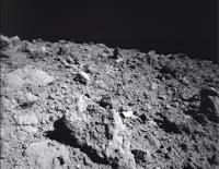
Member Group: Members Posts: 810 Joined: 3-June 04 From: Brittany, France Member No.: 79 |
When looking at pictures of the surface of Ryugu, I always feel hard to estimate the scale: are these rocks or pebbles? How big are these rocks ? Obviously, scalebar helps but I find more helpful to add objects of everyday life to the pictures or people to give the scale.
Here is the result I obtained with Hayabusa 2 and MASCam pictures, adding Harrison Schmitt or a pencil on them. For pictures with no scalebar, I computed the scaled "Harrison Schmitt" on the basis of MASCam FOV, altitude at which pictures were taken and horizontal distance to the object.
      
-------------------- |
|
|
|
|
|
|
Apr 21 2020, 06:03 PM
Post
#90
|
|
|
Forum Contributor Group: Members Posts: 1372 Joined: 8-February 04 From: North East Florida, USA. Member No.: 11 |
QUOTE (neo56 @ Apr 21 2020, 03:26 PM) When looking at pictures of the surface of Ryugu, I always feel hard to estimate the scale: are these rocks or pebbles? How big are these rocks ? Obviously, scalebar helps but I find more helpful to add objects of everyday life to the pictures or people to give the scale. I really like when Earth objects are added to help with the scale. |
|
|
|
|
Apr 21 2020, 06:48 PM
Post
#91
|
|
 Senior Member Group: Members Posts: 4247 Joined: 17-January 05 Member No.: 152 |
Much appreciated, Neo.
In your second pic, it's good to see Schmitt visiting a boulder reminiscent of the split boulder he visited nearly 50 years ago:  (Which, to date me, is one of my very few clear memories of Apollo.) |
|
|
|
|
Apr 28 2020, 08:50 PM
Post
#92
|
|
|
Member Group: Members Posts: 436 Joined: 14-December 15 Member No.: 7860 |
QUOTE (neo56 @ Apr 21 2020, 05:26 PM) ...Here is the result I obtained with Hayabusa 2 and MASCam pictures, adding Harrison Schmitt or a pencil on them... Excellent and very useful! Such photomontage currently probably best reflects the feeling of being on the surface of this little world (which probably will never happen to any of us )
|
|
|
|
|
Mar 23 2021, 05:33 PM
Post
#93
|
|
|
Senior Member Group: Members Posts: 1729 Joined: 3-August 06 From: 43° 35' 53" N 1° 26' 35" E Member No.: 1004 |
open access paper (with some nice images!) on MASCOT results:
Spectrophotometric Analysis of the Ryugu Rock Seen by MASCOT: Searching for a Carbonaceous Chondrite Analog |
|
|
|
|
Sep 23 2023, 02:08 AM
Post
#94
|
|
|
Senior Member Group: Members Posts: 1431 Joined: 26-July 08 Member No.: 4270 |
Apparently a lot of images are now public. Some animations from landru are in this link showing a number of different things.
https://twitter.com/landru79/status/1705304921682108693 -------------------- -- Hungry4info (Sirius_Alpha)
|
|
|
|
|

|
Lo-Fi Version | Time is now: 23rd May 2024 - 11:35 AM |
|
RULES AND GUIDELINES Please read the Forum Rules and Guidelines before posting. IMAGE COPYRIGHT |
OPINIONS AND MODERATION Opinions expressed on UnmannedSpaceflight.com are those of the individual posters and do not necessarily reflect the opinions of UnmannedSpaceflight.com or The Planetary Society. The all-volunteer UnmannedSpaceflight.com moderation team is wholly independent of The Planetary Society. The Planetary Society has no influence over decisions made by the UnmannedSpaceflight.com moderators. |
SUPPORT THE FORUM Unmannedspaceflight.com is funded by the Planetary Society. Please consider supporting our work and many other projects by donating to the Society or becoming a member. |
|