Dawn Survey Orbit Phase, First orbital phase |

  |
Dawn Survey Orbit Phase, First orbital phase |
 Jul 17 2011, 09:09 AM Jul 17 2011, 09:09 AM
Post
#1
|
|
 Senior Member  Group: Members Posts: 1729 Joined: 3-August 06 From: 43° 35' 53" N 1° 26' 35" E Member No.: 1004 |
I think it's time we start a new thread
|
 |
 
|
|
Jul 17 2011, 02:13 PM
Post
#2
|
|||
 Senior Member Group: Members Posts: 2492 Joined: 15-January 05 From: center Italy Member No.: 150 |
Good idea, Paolo!
Dawn's ion engine have been OFF in the last hours (at least 9 hours from my checks) and, as expected, now spacecraft started to accelerate:
at current distance, I espect an acceleration toward Vesta of 1,0e-4 m/s2; considering current phase angle, close to 90°, this should cause an increase of total velocity close to 1 mph each 2 hours... until next engines power on! -------------------- I always think before posting! - Marco -
|
||
|
|
|
||
|
Jul 17 2011, 02:28 PM
Post
#3
|
|
|
Junior Member Group: Members Posts: 50 Joined: 27-June 11 From: Katlenburg-Lindau, Lower Saxony, Germany Member No.: 6038 |
Would it be worth renaming the topic to Survey Orbit Phase, given that it is the name that the mission ops team uses for the first orbital phase?
-------------------- |
|
|
|
|
Jul 17 2011, 03:18 PM
Post
#4
|
|
 IMG to PNG GOD Group: Moderator Posts: 2251 Joined: 19-February 04 From: Near fire and ice Member No.: 38 |
QUOTE (pablogm1024 @ Jul 17 2011, 02:28 PM)  Would it be worth renaming the topic to Survey Orbit Phase, given that it is the name that the mission ops team uses for the first orbital phase? Done - and congratulations to the Dawn team! |
|
|
|
|
Jul 17 2011, 06:53 PM
Post
#5
|
||
|
Senior Member Group: Members Posts: 2492 Joined: 15-January 05 From: center Italy Member No.: 150 |
This is an answer to Greg question (from the old thread):
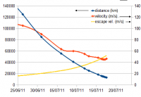
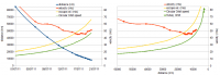
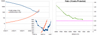
Your question wasn't so silly because helped me to find many answers!  You had a nice idea about plotting escape velocity (which depends on distance from Vesta) toghether with speed... this my updated distance/speed plot, zoomed on last weeks:
You can clearly see the "capture event", when red curve goes below yellow one (speed axis on the right). Well, as told in the press release nobody knows the exact moment of such event because Vesta mass is only roughly known for the moment (I used 2.69e20Kg value, reported also in Wikypedia; uncertain should be around 2%, which means 1% uncertain in escape velocity). EDIT: meanwhile, Dawn is using again propulsion and speed seems stabilized now... -------------------- I always think before posting! - Marco -
|
|
|
|
|
|
|
Jul 18 2011, 05:13 PM
Post
#6
|
||
|
Senior Member Group: Members Posts: 2492 Joined: 15-January 05 From: center Italy Member No.: 150 |
With engines on, Dawn still decelerating, even though at a very slow rate (only 1m/s in last 20 hours) due to Vesta gravity... this is an update of previous plot with a new one (always suggested by Greg) showing speed as a function of distance from Vesta instead of time; I also added a curve showing speed required for circular orbit (pay attention, this is true only if velocity vector is perpendicular to distance vector and this is not the case of Dawn, at this moment!):
Attached thumbnail(s)
-------------------- I always think before posting! - Marco -
|
|
|
|
|
|
|
Jul 18 2011, 07:21 PM
Post
#7
|
|
 Administrator Group: Admin Posts: 5172 Joined: 4-August 05 From: Pasadena, CA, USA, Earth Member No.: 454 |
OK this is making me absolutely crazy. Another image release (yay!) but as with all the previous image releases the reported scale is wrong. They keep reporting the pixel scale for the original, unenlarged image, and then they post an image that has been enlarged (badly) by some non-integer factor and fail to divide the pixel scale by whatever their enlargement factor was.
-------------------- My website - My Patreon - @elakdawalla on Twitter - Please support unmannedspaceflight.com by donating here.
|
|
|
|
|
Jul 18 2011, 07:37 PM
Post
#8
|
||
 The Poet Dude Group: Moderator Posts: 5551 Joined: 15-March 04 From: Kendal, Cumbria, UK Member No.: 60 |
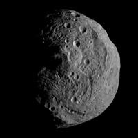
Hands up, I don't understand all the tech stuff, but I sense your frustration Emily.
 Pretty cool view, tho... more and more Mirandan...
-------------------- |
|
|
|
|
|
|
Jul 18 2011, 07:47 PM
Post
#9
|
||
|
Solar System Cartographer Group: Members Posts: 10196 Joined: 5-April 05 From: Canada Member No.: 227 |
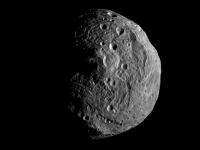
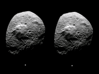
Another version of this beautiful new picture.
Phil
-------------------- ... because the Solar System ain't gonna map itself.
Also to be found posting similar content on https://mastodon.social/@PhilStooke Maps for download (free PD: https://upload.wikimedia.org/wikipedia/comm...Cartography.pdf NOTE: everything created by me which I post on UMSF is considered to be in the public domain (NOT CC, public domain) |
|
|
|
|
|
|
Jul 18 2011, 08:26 PM
Post
#10
|
|
|
Junior Member Group: Members Posts: 21 Joined: 4-November 10 Member No.: 5509 |
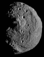
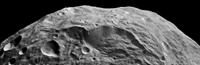
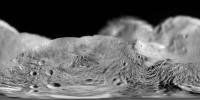
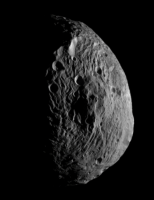
Wow, stunning image.
While the south polar peak is either impact derived or tectonic, it certainly reminds me of Ayers rock in central Australia. Nice hard hard of rock that says "I am not going anywhere, no matter what you throw at me". Also the ripples around the south polar peak really look like ripples in a pond or maybe just wrinkles from shinkage. |
|
|
|
|
Jul 18 2011, 08:31 PM
Post
#11
|
|
 Senior Member Group: Moderator Posts: 2785 Joined: 10-November 06 From: Pasadena, CA Member No.: 1345 |
Straight to Planetary Photojournal:
http://photojournal.jpl.nasa.gov/catalog/PIA14313 http://photojournal.jpl.nasa.gov/catalog/PIA14314 (anaglyph!) http://photojournal.jpl.nasa.gov/catalog/PIA14315 http://photojournal.jpl.nasa.gov/catalog/PIA14316 (asteroid size comparison poster) -------------------- Some higher resolution images available at my photostream: http://www.flickr.com/photos/31678681@N07/
|
|
|
|
|
Jul 18 2011, 09:03 PM
Post
#12
|
|
|
The Poet Dude Group: Moderator Posts: 5551 Joined: 15-March 04 From: Kendal, Cumbria, UK Member No.: 60 |
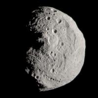
Thanks for posting those links. Used the tiff file to creare a cleaner view...
http://twitpic.com/5s9axu -------------------- |
|
|
|
|
Jul 18 2011, 09:49 PM
Post
#13
|
|
|
Senior Member Group: Moderator Posts: 2785 Joined: 10-November 06 From: Pasadena, CA Member No.: 1345 |
That's really nice, Stu!
-------------------- Some higher resolution images available at my photostream: http://www.flickr.com/photos/31678681@N07/
|
|
|
|
|
Jul 18 2011, 10:09 PM
Post
#14
|
||
 Senior Member Group: Moderator Posts: 3234 Joined: 11-February 04 From: Tucson, AZ Member No.: 23 |
I think I shrunk the original image to something approaching the original resolution. I've also applied a light unsharp mask here:
Attached thumbnail(s)
-------------------- &@^^!% Jim! I'm a geologist, not a physicist!
The Gish Bar Times - A Blog all about Jupiter's Moon Io |
|
|
|
|
|
|
Jul 18 2011, 10:14 PM
Post
#15
|
|
 Member Group: Members Posts: 540 Joined: 25-October 05 From: California Member No.: 535 |
Congrats to the Dawn team for a successful orbit insertion! Now looking forward to a color image of Vesta...

-------------------- 2011 JPL Tweetup photos: http://www.rich-parno.com/aa_jpltweetup.html
http://human-spaceflight.blogspot.com |
|
|
|
|
Jul 18 2011, 10:36 PM
Post
#16
|
|
|
Member Group: Members Posts: 813 Joined: 29-December 05 From: NE Oh, USA Member No.: 627 |
Thanks DAWN team for releasing these. A lot to look forward to in the coming 12 months! Mirandian indeed. Craig |
|
|
|
|
Jul 18 2011, 10:59 PM
Post
#17
|
|
|
Member Group: Members Posts: 293 Joined: 29-August 06 From: Columbia, MD Member No.: 1083 |
Is that picture facing the south pole?
For somewhat not geologically-minded, what is reminding all of you about Miranda? I don't see the similarities really... |
|
|
|
|
Jul 18 2011, 11:09 PM
Post
#18
|
||
 Senior Member Group: Members Posts: 3648 Joined: 1-October 05 From: Croatia Member No.: 523 |
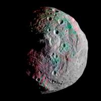
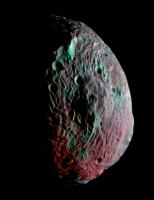
A faux-color version based on color derived from Hubble WFPC2 F673N and F439W filters:
-------------------- |
|
|
|
|
|
|
Jul 18 2011, 11:19 PM
Post
#19
|
|
|
Member Group: Members Posts: 813 Joined: 29-December 05 From: NE Oh, USA Member No.: 627 |
Drkskywxlt:
Call it exhuberance. Mirandian was perhaps more prominant in the lower resolution view from July 9th. Go to NASA photojournal and explore Miranda. Miranda has what I would call sectional terrain (not a geologist either nor do I pretend to be). Odd blocks of internal resurfacing surrounded by cratered terrain. As we get closer the comparisons do seem to break down a bit. Is this a demonstration of how small bodies go through an early stage of internal processing? But is it not wild that we can even make subjective comparisons of bodies so far apart in space and time! That is what some 50 years of solar system exploration has given us. Glad I was born to see it from the start. Craig |
|
|
|
|
Jul 18 2011, 11:54 PM
Post
#20
|
|
|
Junior Member Group: Members Posts: 35 Joined: 10-July 11 Member No.: 6055 |
QUOTE (ugordan @ Jul 18 2011, 03:09 PM) A faux-color version based on color derived from Hubble WFPC2 F673N and F439W filters: ] Nice work. What does everyone think of that big scarp on the upper right area of the image. Could that be the edge of the southern hemisphere impact crater? -kap |
|
|
|
|
Jul 19 2011, 12:03 AM
Post
#21
|
|
|
Senior Member Group: Moderator Posts: 2785 Joined: 10-November 06 From: Pasadena, CA Member No.: 1345 |
QUOTE (kap @ Jul 18 2011, 06:54 PM) What does everyone think of that big scarp on the upper right area of the image. That's a neat cuspate scarp, and another just beside it. I'm looking at the small wavy pile of stuff right in front and wondering if material slumped to reveal an abrupt scarp. -------------------- Some higher resolution images available at my photostream: http://www.flickr.com/photos/31678681@N07/
|
|
|
|
|
Jul 19 2011, 12:07 AM
Post
#22
|
|
|
Member Group: Members Posts: 146 Joined: 31-October 08 Member No.: 4473 |
Boys and girls, it's "Rampant Speculation Time...."
The patterns on the South Pole crater floor do resemble both Miranda, and Earthly sea-floor spreading. Perhaps a shock-melted mantle zone convected for a while, rafting surface debris and local volcanics into linear rows from spreading crack centers. Fun to speculate. Vesta had it's "bell rung" pretty good with the impact, maybe there was a surface wave interference pattern that distributed things in the pattern seen. Relaxation after impact, with the core wanting to re-center, and perhaps migration of the rotation axis, could cause some of the features we see. Also the floor striations could be caused by compressional wrinkling from this relaxation, plus landslides and collapse blocks from the crater rim. Is the central mountain a volcano, an intrusive diapir, an infall debris pile, a garden-variety crater central mound, or a combination? Stay tuned! |
|
|
|
|
Jul 19 2011, 12:25 AM
Post
#23
|
|
|
Member Group: Members Posts: 813 Joined: 29-December 05 From: NE Oh, USA Member No.: 627 |
"But is it not wild that we can even make subjective comparisons of bodies so far apart in space and time!"
My quote from my last post here. Miranda and Vesta...far away in space but perhaps not in time. The period of resurfacing may have been in the same period of time. Early in solar system history. Once again are we seeing how smaller bodies go through an early period of furious internal resurfacing that is restricted to segregated internal blocks of activity. A herterageneous stew that cooks in spots but stays stone cold in others. Shaken... not stirred? Craig |
|
|
|
|
Jul 19 2011, 01:35 AM
Post
#24
|
|
|
Member Group: Members Posts: 146 Joined: 31-October 08 Member No.: 4473 |
There is a big difference between Miranda and Vesta, however. The difference is the presence of ice and tidal forces on Miranda, both largely absent on Vesta.
Ice is quite ductile, and small gravity can cause it to flow, but plain rock, like on Vesta, don't flow unless it is pretty much hot enough to melt, and the interior pressures in Vesta, with it's light gravity, are not going to contribute that strongly. One of the big questions is how warm was the interior of Vesta at impact? We already know (pretty much) that Vesta got hot enough early to differentiate its core/mantle/crust, and then we can ask how much of this heat was left at impact. Since the planet as a whole did not re-spherize itself, it must have been largely cooled to a solid at impact time. Perhaps some of the core was still liquid -- radioactive decay might have kept it going a while. On the other hand, Quite some time might have passed since the planetary system formed and cleared out the nebula and most debris before the impact. We know that a significant amount of asteroidal objects are dynamically related to Vesta and are shards of the great impact. The surface of Vesta also does not appear to be crater-saturated. (With further imaging, crater counts should be able to give a rough age estimate -- looking forward to that.) So it seems (arms waving wildly) that the energy for reshaping parts of Vesta had to be delivered by the energy of impact. How much shock melting could accomplish is unclear, and a better answer is in the hands of the planetary modelers and the mega-computers. An interesting idea is the possibility that accumulated surface volatiles were stirred up by the impact and ablated by solar and impact heating, and Vesta was a giant comet for a while... Well, I think I've embarrassed myself enough for now. Its a free country, gotta love it. |
|
|
|
|
Jul 19 2011, 01:36 AM
Post
#25
|
||
 Member Group: Members Posts: 291 Joined: 29-December 05 From: Ottawa, ON Member No.: 624 |
Sometimes it's easier just to rotate and crop, and just look at a single feature at its best orientation. I just love these cliffs!
Attached thumbnail(s)
|
|
|
|
|
|
|
Jul 19 2011, 01:36 AM
Post
#26
|
|
|
Merciless Robot Group: Admin Posts: 8784 Joined: 8-December 05 From: Los Angeles Member No.: 602 |
I think we'll definitely need a true global view before we'll be able to understand what we're seeing now, but my working hypothesis is that Vesta was damn near remelted globally after this tremendous impact. However, it probably cooled quite quickly as well; we may well be seeing a landscape frozen in time after a catastrophe, perhaps like the ancient Earth (sans atmosphere & oceans) after the big whack that formed the Moon.
-------------------- A few will take this knowledge and use this power of a dream realized as a force for change, an impetus for further discovery to make less ancient dreams real.
|
|
|
|
|
Jul 19 2011, 01:44 AM
Post
#27
|
|
|
Senior Member Group: Members Posts: 2091 Joined: 13-February 10 From: Ontario Member No.: 5221 |
How far will coverage of the northern hemisphere go; will it stay mostly in shadow for the full duration of Dawn's visit?
|
|
|
|
|
Jul 19 2011, 02:06 AM
Post
#28
|
|
|
Member Group: Members Posts: 813 Joined: 29-December 05 From: NE Oh, USA Member No.: 627 |
Shaken or stirred?
That is the question. |
|
|
|
|
Jul 19 2011, 03:13 AM
Post
#29
|
|
 Member Group: Members Posts: 715 Joined: 3-January 08 Member No.: 3995 |
On second thought (or third), it looks like material from the original crater 'wall' has slumped toward the center -- basically the same as what occurs in craters on the moon and Mercury. In this case, though, the slumps have slid all the way to the central peak/uplift, and continued to flow as they were displaced by more material sliding down from above. After eons, a jumbled flow was the result.
|
|
|
|
|
Jul 19 2011, 04:02 AM
Post
#30
|
|
|
Member Group: Members Posts: 146 Joined: 31-October 08 Member No.: 4473 |
Replies...
My understanding is that the North pole of Vesta will just begin to be illuminated at the end of the Vesta mission, so there will be eventual global photo coverage by Dawn. Also, mass wasting from the crater sides does not seem to explain the 5-km-ish spaced parallel ridges on the crater floor. I'm wondering if they are ridges of olivine.... |
|
|
|
|
Jul 19 2011, 04:12 AM
Post
#31
|
|
|
Member Group: Members Posts: 903 Joined: 30-January 05 Member No.: 162 |
Love the "asteroid size comparison poster", amazing to see all the suspects in a police lineup style poster, and LOL, I gets my 1 pixel Itakowa comparison!
|
|
|
|
|
Jul 19 2011, 04:34 AM
Post
#32
|
|
|
Member Group: Members Posts: 316 Joined: 1-October 06 Member No.: 1206 |
I can't wait to see...errrr...the antipode of that crater! Mega chaotic terrain?
P |
|
|
|
|
Jul 19 2011, 04:36 AM
Post
#33
|
|
|
Member Group: Members Posts: 715 Joined: 3-January 08 Member No.: 3995 |
QUOTE (MarkG @ Jul 18 2011, 11:02 PM) Also, mass wasting from the crater sides does not seem to explain the 5-km-ish spaced parallel ridges on the crater floor. I'm wondering if they are ridges of olivine.... They could be pressure ridges between adjacent debris flows. |
|
|
|
|
Jul 19 2011, 10:15 AM
Post
#34
|
|
|
Member Group: Members Posts: 715 Joined: 3-January 08 Member No.: 3995 |
A little bit of Vesta on Mars?:
[attachment=24854:MarsRA_sm.jpg] And on Earth?: [attachment=24855:eastspringcomp.png] (Double Spring landslide complex, Oregon) I had a heck of a time finding a decent example of a terrestrial landslide to compare to Vesta. If the grooved terrain is indeed a system of debris flows, they may turn out to be the finest example of the process anywhere in the Solar System. |
|
|
|
|
Jul 19 2011, 11:17 AM
Post
#35
|
||
 Senior Member Group: Members Posts: 2173 Joined: 28-December 04 From: Florida, USA Member No.: 132 |
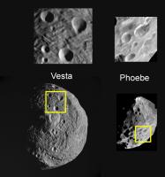
I was intrigued by the quick look Cassini got at the conical craters of Saturn's Phoebe. Now it looks like we'll get a much better look at the same sort of crater on Vesta. The images below are very roughly to the same scale. Although Vesta is a little more than twice the diameter of phoebe, the craters in question seem to be about the same size on both bodies.
|
|
|
|
|
|
|
Jul 19 2011, 11:35 AM
Post
#36
|
|
|
Senior Member Group: Members Posts: 2173 Joined: 28-December 04 From: Florida, USA Member No.: 132 |
QUOTE (Drkskywxlt @ Jul 18 2011, 05:59 PM) For somewhat not geologically-minded, what is reminding all of you about Miranda? I don't see the similarities really... From The Planetary Society Blog: "The interior of that south polar basin sure looks weird. All around the central peak are chevron-shaped ridgy features that bring to mind Miranda -- which, by the way, is very similar in size to Vesta." |
|
|
|
|
Jul 19 2011, 12:37 PM
Post
#37
|
|
|
Member Group: Members Posts: 293 Joined: 29-August 06 From: Columbia, MD Member No.: 1083 |
QUOTE (centsworth_II @ Jul 19 2011, 07:35 AM) From The Planetary Society Blog: "The interior of that south polar basin sure looks weird. All around the central peak are chevron-shaped ridgy features that bring to mind Miranda -- which, by the way, is very similar in size to Vesta." Yeah...I guess I can see that. To me (again, not a geologist), it just all looks like grooves similar to those on other small bodies like Phobos and Lutetia. |
|
|
|
|
Jul 19 2011, 01:22 PM
Post
#38
|
|
|
Junior Member Group: Members Posts: 52 Joined: 16-November 06 Member No.: 1364 |
QUOTE (elakdawalla @ Jul 18 2011, 09:21 PM) OK this is making me absolutely crazy. Another image release (yay!) but as with all the previous image releases the reported scale is wrong. They keep reporting the pixel scale for the original, unenlarged image, and then they post an image that has been enlarged (badly) by some non-integer factor and fail to divide the pixel scale by whatever their enlargement factor was. The last few images were enlarged by an integer factor. Did you find something wrong with how they were enlarged? While the quoted pixel scale is indeed not valid for the enlarged image, it is the relevant number for knowing the smallest detail that can be resolved. |
|
|
|
|
Jul 19 2011, 01:31 PM
Post
#39
|
|
|
Senior Member Group: Members Posts: 2173 Joined: 28-December 04 From: Florida, USA Member No.: 132 |
QUOTE (Drkskywxlt @ Jul 19 2011, 07:37 AM) ...it just all looks like grooves... All groves are not alike. There are straight grooves, sinuous groves, grooves with right angles. |
|
|
|
|
Jul 19 2011, 01:36 PM
Post
#40
|
|
|
Junior Member Group: Members Posts: 52 Joined: 16-November 06 Member No.: 1364 |
QUOTE (punkboi @ Jul 19 2011, 12:14 AM) Congrats to the Dawn team for a successful orbit insertion! Now looking forward to a color image of Vesta... There is a false color image on the MPS Dawn page (click the latest headline). |
|
|
|
|
Jul 19 2011, 02:00 PM
Post
#41
|
|
|
Forum Contributor Group: Members Posts: 1372 Joined: 8-February 04 From: North East Florida, USA. Member No.: 11 |
The focus is getting better.
The Clangers definetly live there. |
|
|
|
|
Jul 19 2011, 02:08 PM
Post
#42
|
|
|
Member Group: Members Posts: 291 Joined: 29-December 05 From: Ottawa, ON Member No.: 624 |
The south polar crater is, by appearances, a flat slice right across the south pole. However, gravity is always pulling towards the center of the body. So on the outer limits of this flat massive basin, it is gravitationally speaking, an up hill slope. This would naturally draw the loose surface material towards the center of the crater, and perhaps create the cracks and rifts, would it not?
|
|
|
|
|
Jul 19 2011, 02:37 PM
Post
#43
|
|
 Member Group: Members Posts: 656 Joined: 20-April 05 From: League City, Texas Member No.: 285 |
Was arrival facing the south polar crater planned, or a coincidence of orbital mechanics and intent to enter a polar orbit? I understand that it is a target of interest, just wondering about the extent of the planning process in that regard.
|
|
|
|
|
Jul 19 2011, 03:03 PM
Post
#44
|
||
|
Senior Member Group: Moderator Posts: 2785 Joined: 10-November 06 From: Pasadena, CA Member No.: 1345 |
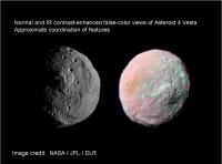
Coordinated views of the normal and contrast-enhanced IR composite of 4 Vesta
(lineup is approximate) note the 4-pack of craters to the N in both images.
-------------------- Some higher resolution images available at my photostream: http://www.flickr.com/photos/31678681@N07/
|
|
|
|
|
|
|
Jul 19 2011, 03:11 PM
Post
#45
|
|
|
Solar System Cartographer Group: Members Posts: 10196 Joined: 5-April 05 From: Canada Member No.: 227 |
Nice one, Mike.
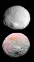
The orange spot in the false color view coincides with the darker spot seen in distant views, including the 'crater with tails' as someone described it, on the edge of the smooth patch we saw a while ago. Phil -------------------- ... because the Solar System ain't gonna map itself.
Also to be found posting similar content on https://mastodon.social/@PhilStooke Maps for download (free PD: https://upload.wikimedia.org/wikipedia/comm...Cartography.pdf NOTE: everything created by me which I post on UMSF is considered to be in the public domain (NOT CC, public domain) |
|
|
|
|
Jul 19 2011, 04:33 PM
Post
#46
|
||
|
Solar System Cartographer Group: Members Posts: 10196 Joined: 5-April 05 From: Canada Member No.: 227 |
Here's a composite to illustrate that.
Phil
-------------------- ... because the Solar System ain't gonna map itself.
Also to be found posting similar content on https://mastodon.social/@PhilStooke Maps for download (free PD: https://upload.wikimedia.org/wikipedia/comm...Cartography.pdf NOTE: everything created by me which I post on UMSF is considered to be in the public domain (NOT CC, public domain) |
|
|
|
|
|
|
Jul 19 2011, 04:51 PM
Post
#47
|
|
|
Administrator Group: Admin Posts: 5172 Joined: 4-August 05 From: Pasadena, CA, USA, Earth Member No.: 454 |
QUOTE (Stefan @ Jul 19 2011, 05:22 AM) The last few images were enlarged by an integer factor. Did you find something wrong with how they were enlarged? The most recent one wasn't -- its enlargement factor was something around 2.2. And the resolutions stated (and widely requoted) in all the released captions are just wrong. With spherical bodies it is very easy to back out an accurate image resolution from a global image -- measure any diameter and you're done. But for bodies with very different principal axis lengths, especially irregular ones like Vesta, it's hard to do this accurately, which prevents me from doing size comparisons. Size comparison posts are some of the most popular things that I do, which is why this is driving me so crazy. As of yesterday I think the press person at JPL now understands what I am complaining about, so hopefully we'll see captions fixed soon. Of course what I really want is for them to quit enlarging the released images. -------------------- My website - My Patreon - @elakdawalla on Twitter - Please support unmannedspaceflight.com by donating here.
|
|
|
|
|
Jul 19 2011, 04:52 PM
Post
#48
|
|
|
Member Group: Members Posts: 146 Joined: 31-October 08 Member No.: 4473 |
QUOTE (Phil Stooke @ Jul 19 2011, 08:11 AM) Nice one, Mike. The orange spot in the false color view coincides with the darker spot seen in distant views, including the 'crater with tails' as someone described it, on the edge of the smooth patch we saw a while ago. Phil The orange area is around the sub-solar point, so I think it just represents daytime heating. Over time, a strong lead or lag behind nearby features with different times-of-day (Vesta Sols!) would be very interesting. |
|
|
|
|
Jul 19 2011, 07:14 PM
Post
#49
|
|
|
Junior Member Group: Members Posts: 52 Joined: 16-November 06 Member No.: 1364 |
QUOTE (elakdawalla @ Jul 19 2011, 06:51 PM) The most recent one wasn't -- its enlargement factor was something around 2.2. And the resolutions stated (and widely requoted) in all the released captions are just wrong. This image was enlarged by a factor 2 (I know because I enlarged it). The resolution of the image as shown here is actually close to the quoted value. But what do you think of the caption here? The media will take that image and do with it whatever they like, and then quote the original numbers. Yes, I understand your concern about the caption, and no, I didn't write it. |
|
|
|
|
Jul 19 2011, 09:18 PM
Post
#50
|
|
|
Administrator Group: Admin Posts: 5172 Joined: 4-August 05 From: Pasadena, CA, USA, Earth Member No.: 454 |
You did the enlargement? It's great to actually talk to someone who knows what's going on
So tell me where I'm wrong here. The diameter of Vesta in that released image is 860 pixels. At 700 m/pixel (1.4 / 2x enlargement) that gives you 600 km diameter, which I *think* is much too large.If the pixel scale were rounded incorrectly and the original image scale were 1.3 km/pixel then it would correspond to 560 km diameter, which is within the accepted range of Vestian diameters... You're right that reporting pixel scales will inevitably result in mainstream media screwing things up. For that reason I'd actually advocate abandoning pixel scales -- ONLY IF the images get released at their original resolution, or if they are enlarged by whole-number factors that are stated in released captions. Those of us who care about these things will get the numbers right. -------------------- My website - My Patreon - @elakdawalla on Twitter - Please support unmannedspaceflight.com by donating here.
|
|
|
|
|
Jul 19 2011, 11:39 PM
Post
#51
|
||
|
Senior Member Group: Moderator Posts: 2785 Joined: 10-November 06 From: Pasadena, CA Member No.: 1345 |
Here's a mashup of the image on the DLR website with high-resolution image PIA14313. I took the enhanced-color IR composite and broke it up into little chunks, then took each chunk and warped it to try to align with surface features in the high res image. Reassembled the color composite, then used that to blend to the high-res layer underneath. Full details on flickr (here)
Neat how the scarp and some of the craters and ejecta are greenish in the IR composite.
-------------------- Some higher resolution images available at my photostream: http://www.flickr.com/photos/31678681@N07/
|
|
|
|
|
|
|
Jul 20 2011, 07:26 AM
Post
#52
|
||
|
Senior Member Group: Members Posts: 2492 Joined: 15-January 05 From: center Italy Member No.: 150 |
An update on Dawn trajectory:
in spite of engine running in last 20 hours, the probe is gently accelerating, progressively approaching a "circular orbit speed", as showed below:
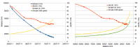
The green triangles indicates definitive survey orbit; they are two because I'm not sure if 2700km nominal height is referred to the center or the surface of Vesta... can someone help me?  As additional info, now average acceleration toward Vesta is 3e-5 m/s2 while angle between trajectory and Vesta-to-Dawn vector is approaching 70°. Addendum: I do not share Emily's bad feeling about image release policy... look to the bright side, last released image was captured only 3 days before and also contrast/gamma is a lot better than previous ones!
-------------------- I always think before posting! - Marco -
|
|
|
|
|
|
|
Jul 20 2011, 02:13 PM
Post
#53
|
|
|
Senior Member Group: Members Posts: 1018 Joined: 29-November 05 From: Seattle, WA, USA Member No.: 590 |
Another interesting stat might be energy/kilogram. Although kinetic energy is increasing, potential energy is decreasing.
--Greg |
|
|
|
|
Jul 20 2011, 03:20 PM
Post
#54
|
|
|
Junior Member Group: Members Posts: 52 Joined: 16-November 06 Member No.: 1364 |
QUOTE (elakdawalla @ Jul 19 2011, 11:18 PM) You did the enlargement? It's great to actually talk to someone who knows what's going on So tell me where I'm wrong here. The diameter of Vesta in that released image is 860 pixels. At 700 m/pixel (1.4 / 2x enlargement) that gives you 600 km diameter, which I *think* is much too large.The distance for that image was (or should have been) 15222 km (center of Vesta). You already know the angular extent of one pixel. You tell me where you are wrong...  We are working to improve the caption. Again, I ask you if you think the enlargement of the last image was done badly. Reading your blog, I am not sure. I used the Mitchell-Netravali algorithm, which I think is appropriate. Remember, it is a tradeoff between blurriness and jagged edge. |
|
|
|
|
Jul 20 2011, 03:29 PM
Post
#55
|
|
|
Founder Group: Chairman Posts: 14433 Joined: 8-February 04 Member No.: 1 |
QUOTE (Stefan @ Jul 20 2011, 07:20 AM) Again, I ask you if you think the enlargement of the last image was done badly. Why is it being done at all? If (as we have been told) there is a constraint on the teams time in producing images for outreach...why waste some of that precious time in un-necessarily enlarging these images? |
|
|
|
|
Jul 20 2011, 03:49 PM
Post
#56
|
|
|
Senior Member Group: Members Posts: 3648 Joined: 1-October 05 From: Croatia Member No.: 523 |
To be fair, that practice of magnifying otherwise poststamp-sized images is pretty much the norm for NASA image advisories, although they do tend to specify the magnification factor in most cases.
-------------------- |
|
|
|
|
Jul 20 2011, 06:09 PM
Post
#57
|
|
 Member Group: Members Posts: 796 Joined: 27-February 08 From: Heart of Europe Member No.: 4057 |
Enlarging images is standard procedure. NASA use that, almost every amateur processor use that. When one is working with mosaic from multiple images, then resizing is even necessary. When one have post-stamp size image, enlarged variant looks somewhat better, than original one.
"waste some of that precious time" It's not, in IrfanView (my favorite software for resampling images) it's matter of seconds. "I used the Mitchell-Netravali algorithm, which I think is appropriate." Mitchell is fine, it's my favorite one, but I think, that it isn't what Emily is complaining about. She simply need information about actual size of pixels, that's all. -------------------- |
|
|
|
|
Jul 20 2011, 09:41 PM
Post
#58
|
|||
|
Member Group: Members Posts: 796 Joined: 27-February 08 From: Heart of Europe Member No.: 4057 |
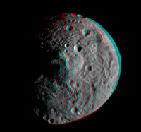
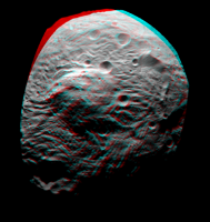
South pole of Vesta in stereo. Cross eye and anaglyph version. Resolution is approx. 1 km/pix.
Stereo images were made from one published hi-res image and synthetic image (made from both published hi-res images).
Attached thumbnail(s)
-------------------- |
||
|
|
|
||
|
Jul 20 2011, 09:48 PM
Post
#59
|
|
|
Senior Member Group: Members Posts: 1276 Joined: 25-November 04 Member No.: 114 |
machi Thank you for the 3D!
My kids appreciate it also! |
|
|
|
|
Jul 20 2011, 10:11 PM
Post
#60
|
|
|
Solar System Cartographer Group: Members Posts: 10196 Joined: 5-April 05 From: Canada Member No.: 227 |
Fantastic! Thanks.
Phil -------------------- ... because the Solar System ain't gonna map itself.
Also to be found posting similar content on https://mastodon.social/@PhilStooke Maps for download (free PD: https://upload.wikimedia.org/wikipedia/comm...Cartography.pdf NOTE: everything created by me which I post on UMSF is considered to be in the public domain (NOT CC, public domain) |
|
|
|
|
Jul 20 2011, 10:56 PM
Post
#61
|
|
 Senior Member Group: Admin Posts: 4763 Joined: 15-March 05 From: Glendale, AZ Member No.: 197 |
QUOTE (machi @ Jul 20 2011, 01:41 PM) South pole of Vesta in stereo. Really nice Daniel. -------------------- If Occam had heard my theory, things would be very different now.
|
|
|
|
|
Jul 21 2011, 12:04 AM
Post
#62
|
|||
|
Member Group: Members Posts: 796 Joined: 27-February 08 From: Heart of Europe Member No.: 4057 |
Thank you all!
I prepared one more cross-eye/anaglyph stereo image, using second published hi-res image.
Attached thumbnail(s)
-------------------- |
||
|
|
|
||
|
Jul 21 2011, 09:07 AM
Post
#63
|
|
 Member Group: Members Posts: 568 Joined: 20-April 05 From: Silesia Member No.: 299 |
Today is Thursday, maybe we'll see images acquired on July 18 ?
http://dawn.jpl.nasa.gov/mission/status.asp Dawn team usually publishes something on Thursday. -------------------- Free software for planetary science (including Cassini Image Viewer).
http://members.tripod.com/petermasek/marinerall.html |
|
|
|
|
Jul 21 2011, 11:17 AM
Post
#64
|
|
|
Member Group: Members Posts: 813 Joined: 29-December 05 From: NE Oh, USA Member No.: 627 |
Awesome!
Thanks machi |
|
|
|
|
Jul 21 2011, 02:17 PM
Post
#65
|
|
|
Solar System Cartographer Group: Members Posts: 10196 Joined: 5-April 05 From: Canada Member No.: 227 |
Recent images would be of a narrow crescent, but in a few days we will be seeing the northern hemisphere... brand new territory again, and from closer range.
Phil -------------------- ... because the Solar System ain't gonna map itself.
Also to be found posting similar content on https://mastodon.social/@PhilStooke Maps for download (free PD: https://upload.wikimedia.org/wikipedia/comm...Cartography.pdf NOTE: everything created by me which I post on UMSF is considered to be in the public domain (NOT CC, public domain) |
|
|
|
|
Jul 21 2011, 02:25 PM
Post
#66
|
|
|
Senior Member Group: Moderator Posts: 2785 Joined: 10-November 06 From: Pasadena, CA Member No.: 1345 |
With such a lumpy surface, the high-phase images should be pretty dramatic.
-------------------- Some higher resolution images available at my photostream: http://www.flickr.com/photos/31678681@N07/
|
|
|
|
|
Jul 21 2011, 04:05 PM
Post
#67
|
|
|
Member Group: Members Posts: 204 Joined: 29-June 05 Member No.: 421 |
QUOTE (Stefan @ Jul 20 2011, 11:20 AM) The distance for that image was (or should have been) 15222 km (center of Vesta). You already know the angular extent of one pixel. You tell me where you are wrong... I'm curious about the answer as well. I get a diameter of 615km trying to replicate the calculation, and I don't see anything wrong with how Emily is doing it. But that is well outside the biggest dimension of the oblate spheroid model. Is it just that the oblate spheroid is that lousy of a fit for vesta's true shape? |
|
|
|
|
Jul 21 2011, 04:46 PM
Post
#68
|
||
|
Solar System Cartographer Group: Members Posts: 10196 Joined: 5-April 05 From: Canada Member No.: 227 |
Hopefully this will be out of date very soon, but here's a composite view of all the closer images we have seen so far. Please let me know if I am missing any.
Phil
(EGD points out - I should have scaled the first to match the long axis dimension, not the polar axis!) -------------------- ... because the Solar System ain't gonna map itself.
Also to be found posting similar content on https://mastodon.social/@PhilStooke Maps for download (free PD: https://upload.wikimedia.org/wikipedia/comm...Cartography.pdf NOTE: everything created by me which I post on UMSF is considered to be in the public domain (NOT CC, public domain) |
|
|
|
|
|
|
Jul 21 2011, 05:35 PM
Post
#69
|
|
|
Junior Member Group: Members Posts: 35 Joined: 10-July 11 Member No.: 6055 |
QUOTE (Phil Stooke @ Jul 21 2011, 06:17 AM) Recent images would be of a narrow crescent, but in a few days we will be seeing the northern hemisphere... brand new territory again, and from closer range. Phil It was my understanding that a good portion of the northern hemisphere will be in darkness (winter) for the first months of the mission, am I mistaken in believing that? -kap |
|
|
|
|
Jul 21 2011, 05:44 PM
Post
#70
|
|
|
Solar System Cartographer Group: Members Posts: 10196 Joined: 5-April 05 From: Canada Member No.: 227 |
Only the north polar area itself will be hidden - most of the northern hemisphere will be visible now.
Phil -------------------- ... because the Solar System ain't gonna map itself.
Also to be found posting similar content on https://mastodon.social/@PhilStooke Maps for download (free PD: https://upload.wikimedia.org/wikipedia/comm...Cartography.pdf NOTE: everything created by me which I post on UMSF is considered to be in the public domain (NOT CC, public domain) |
|
|
|
|
Jul 21 2011, 05:56 PM
Post
#71
|
|
|
Administrator Group: Admin Posts: 5172 Joined: 4-August 05 From: Pasadena, CA, USA, Earth Member No.: 454 |
QUOTE (tfisher @ Jul 21 2011, 08:05 AM) I'm curious about the answer as well. I get a diameter of 615km trying to replicate the calculation, and I don't see anything wrong with how Emily is doing it. But that is well outside the biggest dimension of the oblate spheroid model. Is it just that the oblate spheroid is that lousy of a fit for vesta's true shape? Thanks for checking my math, and now I feel a little more confident in questioning the factor-of-2 enlargement. Here's the DPS abstract on Vesta's dimensions from Hubble data (289, 280, 229 km semi-major axes, or 578, 560, 468 for diameter), which refers to a previous conference abstract with a diameter based on an occultation (561 +/- 3 km). In no way are any of these consistent with any principal axis diameter above 600 kilometers. So either the enlargement factor or the range to the target has not been reported correctly. I know I'm beating a dead horse here and I think the Dawn team now regards me as kind of a pest and really I am very excited about seeing a new world. But it's hard to do outreach when I know that some of the information that I'm getting must be wrong. -------------------- My website - My Patreon - @elakdawalla on Twitter - Please support unmannedspaceflight.com by donating here.
|
|
|
|
|
Jul 21 2011, 06:04 PM
Post
#72
|
|
|
Administrator Group: Admin Posts: 5172 Joined: 4-August 05 From: Pasadena, CA, USA, Earth Member No.: 454 |
Regarding the enlargement, I like neither the blurriness nor the jaggedness of the limb. Both, I think, do a disservice to the FC which I think is supposed to be a very fine instrument. Now that details can be resolved, it's much better just to post images that are not enlarged. Consider the most recently released image of Vesta. Now consider a Cassini image of Phoebe with the same number of pixels. The Cassini image looks so much crisper, and a comparison between the blurry-looking FC image and really any other deep-space camera image makes FC look like a crappy instrument, when we know it's not. it's not a fair comparison, because the Cassini image started out with 800 pixels, while the Dawn one started out with only 400. But most people don't know that; they just see a blurry, pixelated image.
-------------------- My website - My Patreon - @elakdawalla on Twitter - Please support unmannedspaceflight.com by donating here.
|
|
|
|
|
Jul 21 2011, 07:54 PM
Post
#73
|
|
|
Junior Member Group: Members Posts: 52 Joined: 16-November 06 Member No.: 1364 |
QUOTE (elakdawalla @ Jul 21 2011, 07:56 PM) I know I'm beating a dead horse here and I think the Dawn team now regards me as kind of a pest and really I am very excited about seeing a new world. But it's hard to do outreach when I know that some of the information that I'm getting must be wrong. Please realise that at this stage, we face similar uncertainties. There is one thing about which I am 100% sure: the enlargement factor is 2. But then, there are so many possibilities: 1. I calculated the distance wrong, and my colleague made the same mistake 2. The SPICE kernel we used is wrong 3. We used the wrong SPICE kernel 4. The camera FOV has shrunk 5. Your measurement is correct ... We are using trajectory *predictions*! Would it make a difference if I say that we (the FC team) are going through an extremely busy period, in which our main priority is to ensure the FC is in good health and taking images as planned? |
|
|
|
|
Jul 21 2011, 09:00 PM
Post
#74
|
|
|
The Poet Dude Group: Moderator Posts: 5551 Joined: 15-March 04 From: Kendal, Cumbria, UK Member No.: 60 |
QUOTE (elakdawalla @ Jul 21 2011, 06:56 PM) ... I think the Dawn team now regards me as kind of a pest ... I'm sure that's not the case. ...but if any of them do think like that, then I really think they should be grateful that a respected and accomplished science journalist like yourself is so excited by, and passionate about, the mission, wants to ensure its success by writing about it for a public audience, and is trying hard to get the facts straight in order to write accurate reports. -------------------- |
|
|
|
|
Jul 21 2011, 09:06 PM
Post
#75
|
|
|
Administrator Group: Admin Posts: 5172 Joined: 4-August 05 From: Pasadena, CA, USA, Earth Member No.: 454 |
I apologize for being such a pest. I think I don't properly appreciate or understand the differences in navigational certainty between an ion-powered mission -- and one that's approaching a small body with relatively poorly constrained mass -- and the kind of orbital or flyby missions I'm accustomed to writing about. I'm glad to have a definitive answer about the enlargement factor, and now at least I think I understand which bits of information are the sources of the uncertainty. I had assumed wrongly that the range to the target was one of the more precisely known bits of information. So, sorry! I hope you'll take my pestiferousness as a sign of my real interest in and excitement about the mission!
-------------------- My website - My Patreon - @elakdawalla on Twitter - Please support unmannedspaceflight.com by donating here.
|
|
|
|
|
Jul 21 2011, 09:45 PM
Post
#76
|
|
|
Member Group: Members Posts: 204 Joined: 29-June 05 Member No.: 421 |
another thing to question is the size of the error bars on the Hubble measurements of Vesta's size. The Thomas et al 1997 paper is online at http://www2.keck.hawaii.edu/inst/people/co...wg/icarus97.pdf. Skimming through that, they use images with a resolution of 52km per pixel. They estimate errors in the semi-major axes of +/- 5km, or 1/10 of a pixel. I don't know details of their fitting, but it doesnt seem crazy to me that they might have missed by a bigger fraction of a pixel than that. Getting sub-pixel info from images is hard.
|
|
|
|
|
Jul 21 2011, 09:52 PM
Post
#77
|
|
|
Administrator Group: Admin Posts: 5172 Joined: 4-August 05 From: Pasadena, CA, USA, Earth Member No.: 454 |
What surprised me about that paper was that their definitive reference for Vesta's size based on occultation data was from 1989. My 5 minutes of trawling in ADS didn't turn up anything obviously better. Given Vesta's huge size and interesting shape I'm surprised there haven't been more, better-quality occultation studies since then.
EDIT: Looking at fig 2 of that paper, I think it can be stated pretty strongly that no semi-axis of Vesta is at all likely to be longer than 290 km. -------------------- My website - My Patreon - @elakdawalla on Twitter - Please support unmannedspaceflight.com by donating here.
|
|
|
|
|
Jul 21 2011, 10:12 PM
Post
#78
|
|
|
Senior Member Group: Moderator Posts: 2785 Joined: 10-November 06 From: Pasadena, CA Member No.: 1345 |
-------------------- Some higher resolution images available at my photostream: http://www.flickr.com/photos/31678681@N07/
|
|
|
|
|
Jul 21 2011, 10:17 PM
Post
#79
|
|
|
Administrator Group: Admin Posts: 5172 Joined: 4-August 05 From: Pasadena, CA, USA, Earth Member No.: 454 |
OK, now it looks like Hyperion. Vesta's an asteroid of many guises
-------------------- My website - My Patreon - @elakdawalla on Twitter - Please support unmannedspaceflight.com by donating here.
|
|
|
|
|
Jul 21 2011, 10:18 PM
Post
#80
|
|
|
Senior Member Group: Members Posts: 3648 Joined: 1-October 05 From: Croatia Member No.: 523 |
So *that's* what it was reminding me of!
-------------------- |
|
|
|
|
Jul 21 2011, 10:21 PM
Post
#81
|
|
|
Member Group: Members Posts: 204 Joined: 29-June 05 Member No.: 421 |
QUOTE (elakdawalla @ Jul 21 2011, 04:52 PM) Looking at fig 2 of that paper, I think it can be stated pretty strongly that no semi-axis of Vesta is at all likely to be longer than 290 km. I'm not so convinced. My understanding is those numbers are for best fit ellipses. But Vesta has a big chunk missing on one side. Fitting an ellipse to a shape which isn't an ellipse could give a systematic bias. The missing chunk would make all the best fit ellipses underestimate the true maximum dimension. |
|
|
|
|
Jul 21 2011, 10:23 PM
Post
#82
|
|
 Member Group: Members Posts: 723 Joined: 13-June 04 Member No.: 82 |
Has anybody looked at the effects of geometric perspective? Dawn is now close enough to Vesta that it should show a somewhat greater angular diameter as seen from Dawn than you would expect by simply dividing Vesta's diameter by its distance from Dawn. Vesta's edge, as seen by Dawn, is actually slightly closer to Dawn than the "great circle" perpendicular to the line connecting the centre of Vesta with Dawn, which would be slightly smaller as seen by Dawn (if it could be seen through solid rock). Therefore the number of pixels from one side of Vesta to the other would be slightly more than calculated using Vesta's diameter, and its distance from Dawn.
I do not know if the difference would be enough to account for the discrepancy described earlier, but somebody could check? |
|
|
|
|
Jul 21 2011, 10:53 PM
Post
#83
|
|
|
Junior Member Group: Members Posts: 73 Joined: 14-June 05 From: Cambridge, MA Member No.: 411 |
I have a question about Vesta's reference grid. A few days ago an image release specified as "The original image was map-projected, centered at 55 degrees southern latitude and 210 degrees eastern longitude." OK, the latitude is determined by Vesta's spin axis, of course, but how is the system of longitude determined? What feature on Vesta defines 0° (or some other standard) longitude?
|
|
|
|
|
Jul 21 2011, 11:37 PM
Post
#84
|
|
|
Administrator Group: Admin Posts: 5172 Joined: 4-August 05 From: Pasadena, CA, USA, Earth Member No.: 454 |
The answer to that question is in the paper that tfisher linked to: http://www2.keck.hawaii.edu/inst/people/co...wg/icarus97.pdf
QUOTE We propose a prime meridian centered on the most prominent visible feature. This is a nearly circular area, about 200 km across, with a lower albedo than its surroundings. Its origin is unknown at this time. Because it is the largest visible feature on Vesta, the name Olbers Regio has been proposed in honor of the asteroids discoverer; the name is not yet official. We have adjusted the longitude system to put 08 longitude at the center of this feature....
-------------------- My website - My Patreon - @elakdawalla on Twitter - Please support unmannedspaceflight.com by donating here.
|
|
|
|
|
Jul 22 2011, 12:43 AM
Post
#85
|
|
|
Junior Member Group: Members Posts: 73 Joined: 14-June 05 From: Cambridge, MA Member No.: 411 |
QUOTE (elakdawalla @ Jul 21 2011, 07:37 PM) The answer to that question is in the paper that tfisher linked to: http://www2.keck.hawaii.edu/inst/people/co...wg/icarus97.pdf Thanks, Emily ... |
|
|
|
|
Jul 22 2011, 01:49 AM
Post
#86
|
|
|
Senior Member Group: Members Posts: 1018 Joined: 29-November 05 From: Seattle, WA, USA Member No.: 590 |
QUOTE (Mongo @ Jul 21 2011, 03:23 PM) Dawn is now close enough to Vesta that it should show a somewhat greater angular diameter as seen from Dawn than you would expect by simply dividing Vesta's diameter by its distance from Dawn. Well, it's the difference between 2*r/d vs 2*arcsin(r/d), right? So if I take 10,500 km as the distance and 289 km as the radius, then I get an angular diameter of 3 degrees, 9 minutes, 16 seconds. As I figure it, your approximation is 2 seconds smaller. In survey orbit, at 2700 km, the difference will amount to about a minute and a half. (Someone should double check me, though.) --Greg |
|
|
|
|
Jul 22 2011, 03:44 AM
Post
#87
|
|
|
Member Group: Members Posts: 220 Joined: 13-October 05 Member No.: 528 |
I think we have a new image just posted at JPL website. Taken on July 18th.
Not sure how to embed a thumbnail, so I'll just have to put in a link. http://www.nasa.gov/mission_pages/dawn/mul...0721-image.html |
|
|
|
|
Jul 22 2011, 04:11 AM
Post
#88
|
|
|
Founder Group: Chairman Posts: 14433 Joined: 8-February 04 Member No.: 1 |
QUOTE (Mariner9 @ Jul 21 2011, 07:44 PM) I think we have a new image just posted at JPL website. Taken on July 18th. Already being discussed for a page of this thread - first cited here http://www.unmannedspaceflight.com/index.p...mp;#entry175945 |
|
|
|
|
Jul 22 2011, 07:16 AM
Post
#89
|
||
|
Senior Member Group: Members Posts: 2492 Joined: 15-January 05 From: center Italy Member No.: 150 |
QUOTE (Greg Hullender @ Jul 20 2011, 02:13 PM) Another interesting stat might be energy/kilogram. Although kinetic energy is increasing, potential energy is decreasing. Nice idea, Greg; this is the output in terms of energy per mass unit (on the left), with a zoom around the insertion time:
On the right, a plot of ratio between the two energies vs distance (obviously, I considered absolute vaue of potential energy, which is increasing while approaching Vesta); target is a 2700 km distance with a 0.5 ratio (a circular survey orbit). -------------------- I always think before posting! - Marco -
|
|
|
|
|
|
|
Jul 22 2011, 02:09 PM
Post
#90
|
||
|
Solar System Cartographer Group: Members Posts: 10196 Joined: 5-April 05 From: Canada Member No.: 227 |
I have been playing with a very rough map of Vesta from the released images. Please bear in mind this is VERY approximate and not controlled by any shape model or pointing information. It is intended just to show approximate image coverage and locations of major features. The tie to more distant images is very rough. Zero longitude in the Hubble map/shape model coordinates would be at the left end (and the right, I guess). A much earlier version of this, posted here earlier, used a different (arbitrary) zero longitude.
Phil
-------------------- ... because the Solar System ain't gonna map itself.
Also to be found posting similar content on https://mastodon.social/@PhilStooke Maps for download (free PD: https://upload.wikimedia.org/wikipedia/comm...Cartography.pdf NOTE: everything created by me which I post on UMSF is considered to be in the public domain (NOT CC, public domain) |
|
|
|
|
|
|
Jul 22 2011, 07:53 PM
Post
#91
|
|
|
Solar System Cartographer Group: Members Posts: 10196 Joined: 5-April 05 From: Canada Member No.: 227 |
Dawn's looping round the north side now, so the 'where is Dawn' page is showing an illuminated crescent:
http://neo.jpl.nasa.gov/orbits/fullview4.jpg (presumably that links to the current image, when you link to it, not the version I am looking at now) Enough of the surface is visible to see that the texture map currently in use is really from Tethys! Penelope and the chain of craters to its west are visible right now. Phil -------------------- ... because the Solar System ain't gonna map itself.
Also to be found posting similar content on https://mastodon.social/@PhilStooke Maps for download (free PD: https://upload.wikimedia.org/wikipedia/comm...Cartography.pdf NOTE: everything created by me which I post on UMSF is considered to be in the public domain (NOT CC, public domain) |
|
|
|
|
Jul 22 2011, 08:04 PM
Post
#92
|
||
|
Administrator Group: Admin Posts: 5172 Joined: 4-August 05 From: Pasadena, CA, USA, Earth Member No.: 454 |
 Funny, and well spotted! I've attached the current screenshot, since it will have changed by the time some people here look at it. Funny, and well spotted! I've attached the current screenshot, since it will have changed by the time some people here look at it.
Attached thumbnail(s)
-------------------- My website - My Patreon - @elakdawalla on Twitter - Please support unmannedspaceflight.com by donating here.
|
|
|
|
|
|
|
Jul 23 2011, 12:28 PM
Post
#93
|
||
|
Solar System Cartographer Group: Members Posts: 10196 Joined: 5-April 05 From: Canada Member No.: 227 |
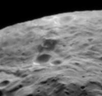
Here's a crater - middle of this view - with dark markings inside and outside its rim. Other distant images show at least one other dark spot like this as well.
Phil
-------------------- ... because the Solar System ain't gonna map itself.
Also to be found posting similar content on https://mastodon.social/@PhilStooke Maps for download (free PD: https://upload.wikimedia.org/wikipedia/comm...Cartography.pdf NOTE: everything created by me which I post on UMSF is considered to be in the public domain (NOT CC, public domain) |
|
|
|
|
|
|
Jul 23 2011, 02:31 PM
Post
#94
|
|
|
Senior Member Group: Admin Posts: 4763 Joined: 15-March 05 From: Glendale, AZ Member No.: 197 |
It looks like maybe a fresh impact inside an older crater.
-------------------- If Occam had heard my theory, things would be very different now.
|
|
|
|
|
Jul 23 2011, 02:34 PM
Post
#95
|
|
|
Solar System Cartographer Group: Members Posts: 10196 Joined: 5-April 05 From: Canada Member No.: 227 |
I'd say excavation of dark subsurface material.
Phil -------------------- ... because the Solar System ain't gonna map itself.
Also to be found posting similar content on https://mastodon.social/@PhilStooke Maps for download (free PD: https://upload.wikimedia.org/wikipedia/comm...Cartography.pdf NOTE: everything created by me which I post on UMSF is considered to be in the public domain (NOT CC, public domain) |
|
|
|
|
Jul 23 2011, 10:13 PM
Post
#96
|
||
|
Member Group: Members Posts: 568 Joined: 20-April 05 From: Silesia Member No.: 299 |
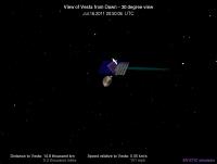
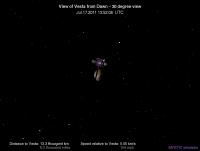
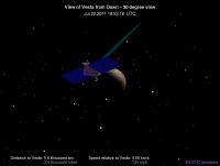
I'm curious if MYSTIC simulator use real data to create the image of Vesta ? Is this a true picture of Vesta? If it corresponds to reality, it is very interesting.
Ion engine is not operating from a few hours, I hope that the framing camera just works. -------------------- Free software for planetary science (including Cassini Image Viewer).
http://members.tripod.com/petermasek/marinerall.html |
|
|
|
|
|
|
Jul 23 2011, 11:09 PM
Post
#97
|
|
 Member Group: Members Posts: 259 Joined: 23-January 05 From: Seattle, WA Member No.: 156 |
As Phil pointed out yesterday, that's Tethys.
|
|
|
|
|
Jul 24 2011, 02:38 AM
Post
#98
|
|
|
Administrator Group: Admin Posts: 5172 Joined: 4-August 05 From: Pasadena, CA, USA, Earth Member No.: 454 |
If our images of Vesta were already that good, we'd have no need of a Dawn mission...
-------------------- My website - My Patreon - @elakdawalla on Twitter - Please support unmannedspaceflight.com by donating here.
|
|
|
|
|
Jul 24 2011, 02:50 AM
Post
#99
|
||
|
Senior Member Group: Moderator Posts: 2785 Joined: 10-November 06 From: Pasadena, CA Member No.: 1345 |
QUOTE (Phil Stooke @ Jul 23 2011, 07:28 AM) Here's a crater - middle of this view - with dark markings inside and outside its rim. Other distant images show at least one other dark spot like this as well. Tried to line up the IR image with this view. If I got it right, that crater is right in the middle of a "greenish" splatty zone. This is the same tint as the sharp scarp face. There are two other greenish splatty zones below the central peak in the image, but I'm almost positive this area is misregistered. I'm going to run with the idea that the green tint indicates fresher material.
-------------------- Some higher resolution images available at my photostream: http://www.flickr.com/photos/31678681@N07/
|
|
|
|
|
|
|
Jul 24 2011, 02:56 AM
Post
#100
|
||
|
Senior Member Group: Moderator Posts: 2785 Joined: 10-November 06 From: Pasadena, CA Member No.: 1345 |
BTW, here's the blink animation between the original black and white image, and the manually warped IR image:
[animated GIF: Click to animate] -------------------- Some higher resolution images available at my photostream: http://www.flickr.com/photos/31678681@N07/
|
|
|
|
|
|
|

|
Lo-Fi Version | Time is now: 23rd June 2024 - 05:46 PM |
|
RULES AND GUIDELINES Please read the Forum Rules and Guidelines before posting. IMAGE COPYRIGHT |
OPINIONS AND MODERATION Opinions expressed on UnmannedSpaceflight.com are those of the individual posters and do not necessarily reflect the opinions of UnmannedSpaceflight.com or The Planetary Society. The all-volunteer UnmannedSpaceflight.com moderation team is wholly independent of The Planetary Society. The Planetary Society has no influence over decisions made by the UnmannedSpaceflight.com moderators. |
SUPPORT THE FORUM Unmannedspaceflight.com is funded by the Planetary Society. Please consider supporting our work and many other projects by donating to the Society or becoming a member. |
|