Distant vistas, Endeavour, Iazu, and beyond |

  |
Distant vistas, Endeavour, Iazu, and beyond |
 Jan 27 2010, 09:31 PM Jan 27 2010, 09:31 PM
Post
#1
|
||
 Senior Member  Group: Members Posts: 4247 Joined: 17-January 05 Member No.: 152 |
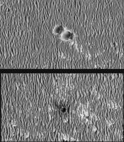
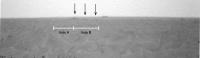
To answer Ustrax's querries from the other thread, I think we can now see more of the
The leftmost (Endeavour north rim) and middle (far rim) features look similar. But it looks like we can see more stuff on the right, which is Endeavour south rim and Iazu. The view we had a few sols ago (2133) of Iazu was still partly obscured by dunes, so it makes sense that we can see more now. I can't see Bopolu in the navcams, though it could be there and buried in the jpeg noise... |
|
 |
 
|
|
|
Jan 27 2010, 09:46 PM
Post
#2
|
|
 Senior Member Group: Admin Posts: 3108 Joined: 21-December 05 From: Canberra, Australia Member No.: 615 |
OT - but relevant to the above...
The spot Oppy's at now is a slight rise compared to the surrounding region, but over the next 5kms or so there's another 45metres of rise before the drop off towards Endeavour. Much better views to come - we'll get the HOAV yet! Are you listening Stu  But first, there's some fun to be had here at Concepción. 
|
|
|
|
|
Jan 28 2010, 10:42 AM
Post
#3
|
|
|
Senior Member Group: Members Posts: 3516 Joined: 4-November 05 From: North Wales Member No.: 542 |
QUOTE (Astro0 @ Jan 27 2010, 09:46 PM)  OT - but relevant to the above... over the next 5kms or so there's another 45metres of rise before the drop off towards Endeavour Am I misreading the map??? To me it looks more or less level as we continue south, then gently downhill all the way once the predicted path turns east. Even then the gradient will be almost imperceptible and Endeavour and Iazu will remain long skinny horizon features. Of course it will be great to have them constantly in sight at last, but anyone hoping for a sweeping grandstand perspective will I think have to wait much longer - until arrival at Endeavour. |
|
|
|
|
Jan 28 2010, 11:44 AM
Post
#4
|
|
|
Senior Member Group: Moderator Posts: 4279 Joined: 19-April 05 From: .br at .es Member No.: 253 |
Looking to the map again, what I see is that we are currently at level "-1370" and the highest point is at "-1325" before dropping down to "-1430" near Mini-Endurance.
|
|
|
|
|
Jan 28 2010, 12:44 PM
Post
#5
|
|
|
Senior Member Group: Members Posts: 3516 Joined: 4-November 05 From: North Wales Member No.: 542 |
QUOTE (Tesheiner @ Jan 28 2010, 11:44 AM) Looking to the map again, what I see is that we are currently at level "-1370" and the highest point is at "-1325" before dropping down to "-1430" near Mini-Endurance. OK - I think that blurry number is 1395, not 1325. I think the contours are at 5m intervals decreasing monotonically along the route. That was my first impression and on taking another careful look I come to the same conclusion. If we still had to climb 45 metres I don't think we'd be seeing distant views now. |
|
|
|
|
Jan 28 2010, 01:06 PM
Post
#6
|
|
|
Solar System Cartographer Group: Members Posts: 10166 Joined: 5-April 05 From: Canada Member No.: 227 |
Ngunn, I was just about to say the same thing. The labels are not very clear, but the contours don't make sense any other way.
Phil -------------------- ... because the Solar System ain't gonna map itself.
Also to be found posting similar content on https://mastodon.social/@PhilStooke Maps for download (free PD: https://upload.wikimedia.org/wikipedia/comm...Cartography.pdf NOTE: everything created by me which I post on UMSF is considered to be in the public domain (NOT CC, public domain) |
|
|
|
|
Jan 28 2010, 02:20 PM
Post
#7
|
|
|
Senior Member Group: Members Posts: 3516 Joined: 4-November 05 From: North Wales Member No.: 542 |
QUOTE (Phil Stooke @ Jan 28 2010, 01:06 PM) the contours don't make sense any other way. Thanks Phil. I was beginning to question my sanity. If people have been reading it the other way that would explain a lot of earlier posts concerning the view that didn't make any sense to me. |
|
|
|
|
Jan 28 2010, 03:24 PM
Post
#8
|
|
|
Member Group: Members Posts: 877 Joined: 7-March 05 From: Switzerland Member No.: 186 |
QUOTE (ustrax @ Jan 28 2010, 01:36 PM) OK, thanks Fred, so Bopulu is on Oppy field of view is that correct? Can someone point where to look if the crater was visible? New pancams are down but no sign of the horizon...or Concepción  Yes, no current pancams in that direction so far, which should roughly be southwestern between 210° to 235° (or -150 to -125 in the PDTInterface) for any signs of Bopulu from the location of Concepción (as measured on your maps). -------------------- |
|
|
|
|
Jan 28 2010, 03:35 PM
Post
#9
|
|
|
Senior Member Group: Members Posts: 3516 Joined: 4-November 05 From: North Wales Member No.: 542 |
I'm also on the lookout for an isolated hill almost directly south (actually the end of a promontory). My impression is it's not yet visible as we have had recent pancams which I think cover that direction.
|
|
|
|
|
Jan 28 2010, 04:35 PM
Post
#10
|
||
|
Senior Member Group: Members Posts: 4247 Joined: 17-January 05 Member No.: 152 |
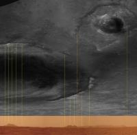
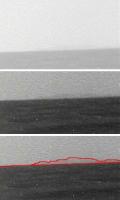
I've done a cross-section plot of the elevations along our actual route between Eagle and Concepción, and from there to Endeavour, to the end of the proposed route originally posted here. This corrects the blurry number 1325 to 1395. Vertical scale 1 m/px, horizontal scale 24 m/px:
Lots of approximations here: Distances are in as-the-crow-flies segments, rather than odometer distances. The proposed map in the abstract contains an error, as pointed out above. The horizontal resolution of the MRO elevation data probably means we can't take the precise topography too seriously. Curvature of the surface of Mars ignored. Still, it gives us an idea of when we might get a HOAV. It looks to me like most of the roughly level plain just west of Endeavour won't be visible until roughly halfway between Concepción and mini Endurance. Curvature works against us, but the Remember that the vertical scale is exagerated 24 times here! This is still Meridiani, after all. So any "HOAV" we get will likely be dramatic only thanks to the wonder of Phil-o-vision. |
|
|
|
|
|
|
Jan 28 2010, 04:44 PM
Post
#11
|
|
|
Solar System Cartographer Group: Members Posts: 10166 Joined: 5-April 05 From: Canada Member No.: 227 |
You're welcome!
Phil -------------------- ... because the Solar System ain't gonna map itself.
Also to be found posting similar content on https://mastodon.social/@PhilStooke Maps for download (free PD: https://upload.wikimedia.org/wikipedia/comm...Cartography.pdf NOTE: everything created by me which I post on UMSF is considered to be in the public domain (NOT CC, public domain) |
|
|
|
|
Jan 28 2010, 04:53 PM
Post
#12
|
|
|
Senior Member Group: Members Posts: 2921 Joined: 14-February 06 From: Very close to the Pyrénées Mountains (France) Member No.: 682 |
"Curvature works against us".
On flat ground, horizon on Earth is at 8 kms (I guess at human eyes). Do you know the figure for Mars? -------------------- |
|
|
|
|
Jan 28 2010, 05:13 PM
Post
#13
|
|
 Senior Member Group: Members Posts: 2173 Joined: 28-December 04 From: Florida, USA Member No.: 132 |
QUOTE (fredk @ Jan 28 2010, 11:35 AM) I've done a cross-section plot of the elevations... Where would the elevation of the rim peaks to south of the proposed arrival point at Endeavour fall on that plot?
|
|
|
|
|
Jan 28 2010, 05:53 PM
Post
#14
|
|
|
Senior Member Group: Members Posts: 4247 Joined: 17-January 05 Member No.: 152 |
At the pancam height of 1.55 m, the horizon on Mars is 3.2 km away. Another way to look at is is that in 5 km (most of the way to mini Endurance), the ground will drop by 3.7 m due to curvature. It drops 15 m after 10 km distance.
It looks like we can't resolve those rim peaks on the contour map. But the fact that we could see them since Victoria means they're higher than our current elevation, probably by a fair bit. (Perhaps any more discussion should go to the other thread...) |
|
|
|
|
Jan 29 2010, 03:48 AM
Post
#15
|
||
|
Senior Member Group: Members Posts: 4247 Joined: 17-January 05 Member No.: 152 |
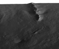
QUOTE (ngunn @ Jan 28 2010, 04:35 PM) I'm also on the lookout for an isolated hill almost directly south (actually the end of a promontory). Me too. Could this be it? This is looking SSW-ish, but I'm not sure if the azimuth is exactly right:
|
|
|
|
|
|
|
Jan 29 2010, 05:22 AM
Post
#16
|
||
|
Senior Member Group: Members Posts: 4247 Joined: 17-January 05 Member No.: 152 |
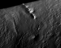
So much to see in these latest navcams. Here's an example of a definite dark feature on the horizon, in front of (part of??) Iazu Crater (lighter band above horizon):
I think this is what you were refering to recently, Ustrax? My kingdom for a pancam view... 
|
|
|
|
|
|
|
Jan 30 2010, 08:05 AM
Post
#17
|
|
|
Member Group: Members Posts: 877 Joined: 7-March 05 From: Switzerland Member No.: 186 |
QUOTE (Tman @ Jan 28 2010, 04:24 PM) Yes, no current pancams in that direction so far, which should roughly be southwestern between 210° to 235° (or -150 to -125 in the PDTInterface) for any signs of Bopulu from the location of Concepción (as measured on your maps). There are new pancams now, but only downsampled EDRs and nothing obvious. Center of the image ~213°: https://qt.exploratorium.edu/mars/opportuni...66P2277L1M1.JPG ~225°: https://qt.exploratorium.edu/mars/opportuni...66P2277L1M1.JPG ~238°: https://qt.exploratorium.edu/mars/opportuni...66P2277L1M1.JPG Also for that isolated hill southward. -------------------- |
|
|
|
|
Jan 30 2010, 11:04 AM
Post
#18
|
|
|
Senior Member Group: Members Posts: 3516 Joined: 4-November 05 From: North Wales Member No.: 542 |
Comment and query copied from the other thread:
I note that the nearest Endeavour 'rim' hills actually rise from some way down inside the hole so we won't see their feet till we're almost there. In the Endeavour Crater thread there was a very nice HRSC 3D view of Endeavour which somebody annotated with elevations. I wanted to look at that again but the HRSC links no longer work for me. Can anybody help with that? |
|
|
|
|
Jan 30 2010, 10:58 PM
Post
#19
|
|
 Special Cookie Group: Members Posts: 2168 Joined: 6-April 05 From: Sintra | Portugal Member No.: 228 |
QUOTE (fredk @ Jan 29 2010, 05:22 AM) I think this is what you were refering to recently, Ustrax? My kingdom for a pancam view... Exactly Fred! Thanks. Looks like a real feature but I am having some hard time figuring out what it may be comparing with satellite imagery... This is definitely my kind of thread...bring those pancams and let us find some abysses and stuff! 
-------------------- "Ride, boldly ride," The shade replied, "If you seek for Eldorado!"
Edgar Alan Poe |
|
|
|
|
Jan 31 2010, 09:21 AM
Post
#20
|
|
|
Senior Member Group: Moderator Posts: 4279 Joined: 19-April 05 From: .br at .es Member No.: 253 |
http://qt.exploratorium.edu/mars/opportuni...66P2368L7M1.JPG
No doubt at all about which is rear or far rim... Edit: And, at least for me, this is already a HOAV! |
|
|
|
|
Jan 31 2010, 09:30 AM
Post
#21
|
||
 The Poet Dude Group: Moderator Posts: 5551 Joined: 15-March 04 From: Kendal, Cumbria, UK Member No.: 60 |
You want a "Distant Vista"???!!
-------------------- |
|
|
|
|
|
|
Jan 31 2010, 09:32 AM
Post
#22
|
|
|
Special Cookie Group: Members Posts: 2168 Joined: 6-April 05 From: Sintra | Portugal Member No.: 228 |
QUOTE (Stu @ Jan 31 2010, 09:30 AM) You want a "Distant Vista"???!! Punch me more...I love it!!!  -------------------- "Ride, boldly ride," The shade replied, "If you seek for Eldorado!"
Edgar Alan Poe |
|
|
|
|
Jan 31 2010, 09:59 AM
Post
#23
|
|
|
Merciless Robot Group: Admin Posts: 8784 Joined: 8-December 05 From: Los Angeles Member No.: 602 |
I knew there had to be a significant up-side to chronic insomnia!!!
 Beauty & great scientific treasures now in sight, and we few are among the first to ever see such a scene on this world. In the next hours, possibly millions of others will join us. Beauty & great scientific treasures now in sight, and we few are among the first to ever see such a scene on this world. In the next hours, possibly millions of others will join us.
-------------------- A few will take this knowledge and use this power of a dream realized as a force for change, an impetus for further discovery to make less ancient dreams real.
|
|
|
|
|
Jan 31 2010, 10:14 AM
Post
#24
|
||
|
The Poet Dude Group: Moderator Posts: 5551 Joined: 15-March 04 From: Kendal, Cumbria, UK Member No.: 60 |
... and if you stretch the horizon until it begs for mercy you can see just how hilly it is...
-------------------- |
|
|
|
|
|
|
Jan 31 2010, 10:33 AM
Post
#25
|
|
|
Senior Member Group: Members Posts: 3516 Joined: 4-November 05 From: North Wales Member No.: 542 |
QUOTE (nprev @ Jan 31 2010, 09:59 AM) I knew there had to be a significant up-side to chronic insomnia! Or (over here) staying in bed long enough. Thanks for those first mosaics Stu. A great moment - we are truly blessed. |
|
|
|
|
Jan 31 2010, 01:14 PM
Post
#26
|
|
|
Senior Member Group: Members Posts: 3516 Joined: 4-November 05 From: North Wales Member No.: 542 |
Are we still happy with these identifications?
http://www.unmannedspaceflight.com/index.p...st&id=15887 Is that big dark peak right of centre (of Endeavour) really on the far rim, and if so what's that beyond it? |
|
|
|
|
Jan 31 2010, 01:20 PM
Post
#27
|
|
 Member Group: Members Posts: 813 Joined: 8-February 04 From: Arabia Terra Member No.: 12 |
Takes me back to Spirit's first winter and watching Gusev crater's walls slowly appear as the dust levels dropped.
Amazingly Oppy is only about 16% closer to the big hills on the near side than it was back in Duck Bay! Once they finish heading south and start moving due east the view should improve very quickly. At mini Endurance the distance between Oppy and the big near side hills will be almost exactly half of what it was during autumn 2006. |
|
|
|
|
Jan 31 2010, 02:02 PM
Post
#28
|
|
 Senior Member Group: Moderator Posts: 2262 Joined: 9-February 04 From: Melbourne - Oz Member No.: 16 |
QUOTE (ngunn @ Jan 31 2010, 01:14 PM) Are we still happy with these identifications? http://www.unmannedspaceflight.com/index.p...st&id=15887 Is that big dark peak right of centre (of Endeavour) really on the far rim, and if so what's that beyond it? Yes, I'm still happy with that. I think you might be confused as to which peak is which. (I'm working on the pan and a feature identification plot). 'Cook' the big hill in the middle of the far rim from our POV is the peak on the far left of the images posted, nothing can be seen beyond it. In the middle, is part of the near rim where we are headed with Izau behind it. James -------------------- |
|
|
|
|
Jan 31 2010, 02:10 PM
Post
#29
|
|
|
Senior Member Group: Members Posts: 3516 Joined: 4-November 05 From: North Wales Member No.: 542 |
QUOTE (jamescanvin @ Jan 31 2010, 02:02 PM) I think you might be confused Indeed! Thanks. I can't wait to see the full picture you're working on. |
|
|
|
|
Jan 31 2010, 02:30 PM
Post
#30
|
|
 Senior Member Group: Members Posts: 1431 Joined: 26-July 08 Member No.: 4270 |
QUOTE (ngunn @ Jan 31 2010, 08:10 AM) I can't wait to see the full picture you're working on. A frame showing the centre of Concepcion is missing a colour filter or something, leaving it nastily discoloured. I won't claim to speak for him of course, but I would guess that what he posted is the finished project. (any further to the right and it gets pretty terrible) -------------------- -- Hungry4info (Sirius_Alpha)
|
|
|
|
|
Jan 31 2010, 02:33 PM
Post
#31
|
|
 Member Group: Members Posts: 221 Joined: 25-March 05 Member No.: 217 |
Hi all
It seems all I can say when posting here is "brilliant views" I remember when Columbia Hills was about the same size as Endeavour is now on the horizon and how keen I (we ) were to get there. Now I've never been so torn between seeing whats at our feet and everything that's up ahead. Either way everyday from now is going to be brilliant views. Thanks again to all for the stuff on this website. Roy F |
|
|
|
|
Jan 31 2010, 02:53 PM
Post
#32
|
|
|
Founder Group: Chairman Posts: 14432 Joined: 8-February 04 Member No.: 1 |
What's kind of cool is that these images of the horizon were taken 16 hrs ago. Seriously - just 16 hrs ago.
|
|
|
|
|
Jan 31 2010, 03:06 PM
Post
#33
|
|
|
The Poet Dude Group: Moderator Posts: 5551 Joined: 15-March 04 From: Kendal, Cumbria, UK Member No.: 60 |
...and I made my pan at 7am, so they were just 8 hours old then?!?!
That's fantastic! (And ESA still hasn't released those 'crescent Mars' images taken by Rosetta years ago. Just saying.) -------------------- |
|
|
|
|
Jan 31 2010, 03:55 PM
Post
#34
|
|
 Senior Member Group: Moderator Posts: 2785 Joined: 10-November 06 From: Pasadena, CA Member No.: 1345 |
(at least some cameras ESA flies near Mars have a rapid turnaround: (*cough*) http://webservices.esa.int/blog/post/6/958)
-------------------- Some higher resolution images available at my photostream: http://www.flickr.com/photos/31678681@N07/
|
|
|
|
|
Jan 31 2010, 04:02 PM
Post
#35
|
||
|
Senior Member Group: Moderator Posts: 2262 Joined: 9-February 04 From: Melbourne - Oz Member No.: 16 |
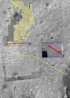
Here are the horizon features plotted alongside another 'inverse-polar' map from this position.
I've drawn guide lines from the peaks to appropriate positions on the map in yellow and orange lines highlight the visible extent of Izau (I'm still thinking about identification of peaks) James -------------------- |
|
|
|
|
|
|
Jan 31 2010, 04:25 PM
Post
#36
|
|
|
Solar System Cartographer Group: Members Posts: 10166 Joined: 5-April 05 From: Canada Member No.: 227 |
The great thing about this is that the view is just going to get better all the time. Apart from the possibility of losing it very briefly behind local drifts in the next one or two km, we'll always have it, and it will get closer and the middle distance will open up more all the time. Exploration at its greatest, as some guy once said.
Phil -------------------- ... because the Solar System ain't gonna map itself.
Also to be found posting similar content on https://mastodon.social/@PhilStooke Maps for download (free PD: https://upload.wikimedia.org/wikipedia/comm...Cartography.pdf NOTE: everything created by me which I post on UMSF is considered to be in the public domain (NOT CC, public domain) |
|
|
|
|
Jan 31 2010, 04:26 PM
Post
#37
|
|
|
Senior Member Group: Members Posts: 3516 Joined: 4-November 05 From: North Wales Member No.: 542 |
That's excellent, thanks James! Now we can clearly see that the very nearest rim hills (maybe in fact a slumped portion of the original rim?) are still entirely out of sight below the level surface we are looking across. I thought that might be the case from my attempts to decipher the spot heights on the map, but I'm pretty wary of those now. Seeing is believing.
EDIT: Why the interest in those invisible hiils? I think that's the location of some curious shoreline-like landforms we discussed a while ago and possibly a future destination. |
|
|
|
|
Jan 31 2010, 05:17 PM
Post
#38
|
||
|
Senior Member Group: Members Posts: 4247 Joined: 17-January 05 Member No.: 152 |
Fantastic views! Thanks everyone for putting together these mosaics.
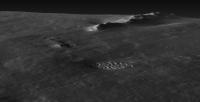
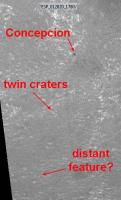
QUOTE (ustrax @ Jan 30 2010, 11:58 PM) Looks like a real feature but I am having some hard time figuring out what it may be comparing with satellite imagery... I've ID'ed Ustrax's dark feature - see the white line I added to James' superb inverse polar. It looks like it's a "head" at the closest point of the plateau around Iazu. Interesting that we're now seeing that that plateau is almost as high as the rim of Iazu.Also, it's cool that we're really starting to see features on the features now, at least on the Endeavour rim. I've made a very tentative ID of a crater on the far rim of Endeavour (white circles). As others have said, the view will get better and better. But on top of improved sight lines, as we head into winter the transparency should improve as well, so we should see more features on these features too. Edit: I guess I was so excited I forgot to add my pic! Here it is:
|
|
|
|
|
|
|
Jan 31 2010, 05:18 PM
Post
#39
|
|
|
Senior Member Group: Members Posts: 3516 Joined: 4-November 05 From: North Wales Member No.: 542 |
QUOTE (Phil Stooke @ Jan 31 2010, 04:25 PM) The great thing about this is that the view is just going to get better all the time. From the 'vistas' point of view the proposed route is perfect. The next short trek SW and S should open up the distant horizon in those directions also before we turn E. |
|
|
|
|
Jan 31 2010, 07:33 PM
Post
#40
|
|
|
Junior Member Group: Members Posts: 71 Joined: 19-January 10 From: Grimsby, N.E. Lincs, UK Member No.: 5179 |
Like many previous posts I am just in awe of both the views we are beginning to experience and the expertise of those UMSF members who take the time and trouble to allow us to see these vistas in such a quick, easy and beautiful manner. A big thank you to you all.
I am trying to keep my excitement down to bearable levels (I have already learnt how tiring the emotional rollercoaster highs and lows associated with these two rovers can be!) so i'll simply ask these two questions; 1 - Are the current power levels on Opportunity any cause for concern re reaching Endeavour? (I just have this nightmare of us running out of juice 5 metres from the rim!) 2 - From the photos above it appears that whilst Endeavour is the larger crater and is our target, i think it would be fair to say it looks as though Lazu has an amazing rim. Would there be anything to be gained from trying to get there as well? (I do appreciate it is a long way away but is there anything to suggest it is significantly different from endeavour?) Finally, I agree with Teshiner, we are definitely in HOAV area! However, I think that bar might be raised in the upcoming months...  Neil |
|
|
|
|
Jan 31 2010, 08:02 PM
Post
#41
|
||
|
Senior Member Group: Members Posts: 2173 Joined: 28-December 04 From: Florida, USA Member No.: 132 |
QUOTE (Reckless @ Jan 31 2010, 09:33 AM) I remember when Columbia Hills was about the same size as Endeavour is now on the horizon and how keen I (we ) were to get there.... Opportunity still has a much longer way to go than Spirit did. While Spirit has had a much rougher trek, Opportunity has been the long distance runner. Here is an inset showing the distance covered by Spirit from Bonneville crater to the Columbia Hills. I estimated the scale based on 2.5 km from Bonneville to the Hills compared with a little over 4.5 km from Victoria to Concepcion.
|
|
|
|
|
|
|
Jan 31 2010, 08:06 PM
Post
#42
|
|
|
Senior Member Group: Members Posts: 2173 Joined: 28-December 04 From: Florida, USA Member No.: 132 |
QUOTE (NW71 @ Jan 31 2010, 02:33 PM) 1 - Are the current power levels on Opportunity any cause for concern re reaching Endeavour? 2 - ...Lazu has an amazing rim. Would there be anything to be gained from trying to get there as well? 1. Power should be no problem, barring another killer dust storm. The biggest problem in my opinion would be mechanical or electrical failures because of age. (Hopefully the rover is now too smart to get stuck in the sand.) 2. Ask again in two years.
|
|
|
|
|
Jan 31 2010, 08:18 PM
Post
#43
|
||
|
Senior Member Group: Members Posts: 4247 Joined: 17-January 05 Member No.: 152 |
Neil, Squyres was asked about Oppy's power levels at the recent briefing and he said they weren't a concern.
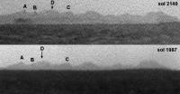
Here's a comparison between the view at sol 1987 (from Astro's mosaic) with the 2140 view (from James' mosaic). Both at 3x vertical stretch. Stunning improvement indeed for Endeavour west rim/Iazu. And significant perspective change - note white line connecting the west rim peaks. Changes within Iazu as well due to near/far rim perspective change, as I remarked earlier when I posted my long baseline anaglyph.
|
|
|
|
|
|
|
Jan 31 2010, 08:26 PM
Post
#44
|
|
|
Member Group: Members Posts: 221 Joined: 25-March 05 Member No.: 217 |
Hi Centsworth_II
I did realize that Oppy is further from Endeavour than Spirit was at Bonneville and thank you for the comparison map all maps are always welcome especially maps with helpful inserts. Roy F |
|
|
|
|
Jan 31 2010, 09:03 PM
Post
#45
|
|
|
Member Group: Members Posts: 194 Joined: 3-January 10 Member No.: 5156 |
Cool. Spirit needed only 68 Sols from Bonneville to the Hills (Sol 86 to 154). I estimate the route to endeavour from conception as 4,5 times the route from Bonneville to the Hills (11.25 km? a little short I think) , that means we only need 306 sols to get there :-) But that's of course a minimum guess, maybe we see some interesting stuff on the road ...
-------------------- Need more input ...
|
|
|
|
|
Jan 31 2010, 10:58 PM
Post
#46
|
|
|
Senior Member Group: Moderator Posts: 4279 Joined: 19-April 05 From: .br at .es Member No.: 253 |
Below the minimum, I would say.
Check the route from e.g. VC up to here and that would give you a better km/month figure.
|
|
|
|
|
Jan 31 2010, 11:09 PM
Post
#47
|
|
|
Founder Group: Chairman Posts: 14432 Joined: 8-February 04 Member No.: 1 |
Time and again we've played the X metres in Y sols means Z progress game.
It never works Ever. |
|
|
|
|
Jan 31 2010, 11:14 PM
Post
#48
|
|
|
Merciless Robot Group: Admin Posts: 8784 Joined: 8-December 05 From: Los Angeles Member No.: 602 |
The old saying "You can have it done fast, or you can have it done right" seems applicable here.

-------------------- A few will take this knowledge and use this power of a dream realized as a force for change, an impetus for further discovery to make less ancient dreams real.
|
|
|
|
|
Feb 1 2010, 05:52 AM
Post
#49
|
|
 Member Group: Members Posts: 399 Joined: 28-August 07 From: San Francisco Member No.: 3511 |
Feels like the road to Endurance again, which is cool
-------------------- 'She drove until the wheels fell off...'
|
|
|
|
|
Feb 1 2010, 12:34 PM
Post
#50
|
||
|
Senior Member Group: Admin Posts: 3108 Joined: 21-December 05 From: Canberra, Australia Member No.: 615 |
Stretchy horizon comparison - animation.
|
|
|
|
|
|
|
Feb 1 2010, 02:06 PM
Post
#51
|
|
|
Special Cookie Group: Members Posts: 2168 Joined: 6-April 05 From: Sintra | Portugal Member No.: 228 |
QUOTE (Astro0 @ Feb 1 2010, 12:34 PM) Stretchy horizon comparison - animation. Now you've done it...let me have it! let me have it!!!
-------------------- "Ride, boldly ride," The shade replied, "If you seek for Eldorado!"
Edgar Alan Poe |
|
|
|
|
Feb 1 2010, 03:10 PM
Post
#52
|
|
 Senior Member Group: Members Posts: 1619 Joined: 12-February 06 From: Bergerac - FR Member No.: 678 |
OMG !! This is amazing Astro0 !! We really have the feeling of a progression now.
-------------------- |
|
|
|
| Guest_Oersted_* |
Feb 1 2010, 05:30 PM
Post
#53
|
|
Guests |
Oh, yes, that is a great animated gif Astro0!
|
|
|
|
|
Feb 1 2010, 06:38 PM
Post
#54
|
|
|
Member Group: Members Posts: 194 Joined: 3-January 10 Member No.: 5156 |
Cool animation. I starred the whole day long at it, and now I think I glaciers at the Endeavour rim ... ok I starred to much.
But I hope we will get soon a third picture to this animation. -------------------- Need more input ...
|
|
|
|
|
Feb 1 2010, 08:18 PM
Post
#55
|
|
 Member Group: Members Posts: 404 Joined: 5-January 10 Member No.: 5161 |
QUOTE (Astro0 @ Feb 1 2010, 04:34 AM) Stretchy horizon comparison - animation. Wow! That's the first time it looks like a crater, with the foreground and background rim-mountains clearly visible in the same shot. |
|
|
|
|
Feb 1 2010, 08:41 PM
Post
#56
|
|
|
Senior Member Group: Moderator Posts: 4279 Joined: 19-April 05 From: .br at .es Member No.: 253 |
QUOTE (MoreInput @ Feb 1 2010, 07:38 PM) But I hope we will get soon a third picture to this animation. Hear! Hear! |
|
|
|
|
Feb 1 2010, 08:58 PM
Post
#57
|
|
|
Senior Member Group: Moderator Posts: 4279 Joined: 19-April 05 From: .br at .es Member No.: 253 |
QUOTE (NW71 @ Jan 31 2010, 08:33 PM) 1 - Are the current power levels on Opportunity any cause for concern re reaching Endeavour? (I just have this nightmare of us running out of juice 5 metres from the rim!) Two things. First of all, just say to everyone that AJS Rayl monthly report on the rovers is already online. Second, an extract from the named report: QUOTE "Opportunity is also a little bit energy-limited for its mission", said Matijevic. Its power levels dropped from a high of 336 watt-hours earlier this month to "about 290 watt-hours" as the weekend began. The team expects this rovers power production to remain "in the 250 regimes for most of the next couple of months," he added. "It will drive as far as it can on any given day, basically drive down the batteries and recharge them the next day, so you should see a pattern of where we drive every other day at best.
|
|
|
|
|
Feb 3 2010, 10:00 AM
Post
#58
|
||||
|
Junior Member Group: Members Posts: 59 Joined: 18-July 07 From: London, UK Member No.: 2873 |
I've been meaning to post this for a while now, and the recent chat has spurred me on.
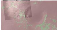
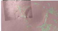
I've had a go at predicting what Opportunity can possibly see, both now and further along the predicted route. I took the HRSC topo for the area, overlaid a CTX image, plonked down a marker for (roughly) where I thought Oppy was at the time (about a week ago now), and then let ArcMap figure out what's visible for something 1.8 m off the ground at that point. I then tried again for a different point along the predicted path. So here's the base map for the area. The green dot is my poor attempt at a location.
This is what might be visible at the moment (green is visible, red, er, isn't)
And this is what might be visible in the future (from the red dot)
This method is very sensitive to both the underlying DEM and the exact location you view from. I can get very different results by moving the marker just a tiny distance. So take it with a pinch of salt, and then add a bucket or so extra for good measure. It'd obviously be loads better if I could stick a HiRISE DEM underneath, as this method worked pretty well for the Pathfinder DEM. I'm actually hoping that the view heading down the gentle slope will be a lot better than this predicts. Pete |
|||
|
|
|
|||
|
Feb 3 2010, 10:42 AM
Post
#59
|
|
|
Founder Group: Chairman Posts: 14432 Joined: 8-February 04 Member No.: 1 |
Pete - chuck that Pathfinder demo of Viewshed in here as well ( I never got around to using it) - it demonstrates the power of the technique.
What Pete has shown ( for those who haven't figured it out ) is that certainly for the next several KM - we're not going to have a sudden OMFG HOAV moment - it will be a gradual progression as we've seen with Astro0's recent flicking GIF. |
|
|
|
|
Feb 3 2010, 01:53 PM
Post
#60
|
|
|
Senior Member Group: Moderator Posts: 4279 Joined: 19-April 05 From: .br at .es Member No.: 253 |
QUOTE (pgrindrod @ Feb 3 2010, 11:00 AM) This method is very sensitive to both the underlying DEM and the exact location you view from. I can get very different results by moving the marker just a tiny distance. So take it with a pinch of salt, and then add a bucket or so extra for good measure. It'd obviously be loads better if I could stick a HiRISE DEM underneath, as this method worked pretty well for the Pathfinder DEM. My kingdom for a HiRISE DEM!
|
|
|
|
|
Feb 3 2010, 02:04 PM
Post
#61
|
|
|
Junior Member Group: Members Posts: 59 Joined: 18-July 07 From: London, UK Member No.: 2873 |
QUOTE (djellison @ Feb 3 2010, 10:42 AM) Pete - chuck that Pathfinder demo of Viewshed in here as well ( I never got around to using it) - it demonstrates the power of the technique. Yes boss! I'll stick it over in the HiRISE DEM thread. Pete |
|
|
|
|
Feb 3 2010, 02:40 PM
Post
#62
|
|
|
Senior Member Group: Members Posts: 3516 Joined: 4-November 05 From: North Wales Member No.: 542 |
There are just great. Any chance you could extend the area S and SW to check out the potential visibility of Bopulu and 'south hill' from a little south of our present position?
|
|
|
|
|
Feb 3 2010, 02:53 PM
Post
#63
|
|
 Senior Member Group: Admin Posts: 4763 Joined: 15-March 05 From: Glendale, AZ Member No.: 197 |
Did we all notice that the SW flank of Victoria should still be visible? ( with deference to the pinch of salt and all that)
-------------------- If Occam had heard my theory, things would be very different now.
|
|
|
|
|
Feb 3 2010, 02:57 PM
Post
#64
|
|
|
Senior Member Group: Admin Posts: 4763 Joined: 15-March 05 From: Glendale, AZ Member No.: 197 |
QUOTE (ngunn @ Feb 3 2010, 06:40 AM) Any chance you could extend the area S and SW to check out the potential visibility of Bopulu and 'south hill' from a little south of our present position? If we were really greedy we would ask them to animate the sequence down the drive path so we'd see green features growing and shrinking in the view from above with an in-set image showing a red dot moving down the drive path. But that would take a lot of time and all we have to offer is boundless admiration and praise. -------------------- If Occam had heard my theory, things would be very different now.
|
|
|
|
|
Feb 3 2010, 06:50 PM
Post
#65
|
|
|
Senior Member Group: Members Posts: 4247 Joined: 17-January 05 Member No.: 152 |
QUOTE (pgrindrod @ Feb 3 2010, 11:00 AM) I've had a go at predicting what Opportunity can possibly see This is really cool, Pete. I've got a couple of questions/comments. First, does this take into account the curvature of the surface? Your results definitely look sensible along the inside of the far rim of Endeavour, presumably since the slope is quite large there. But in both plots, there are areas right adjacent to the observation point that aren't green. Why is that? I can see that the blotchiness of the green areas on the flatter areas makes sense, since the slopes there are extremely small. But it should still be green close to the observation point. I see what you mean by the green areas changing quite a bit when you move the observation point around - again, since the terrain is so flat. I wonder if you could do a series of these plots, each time moving the obs. point around a bit (say within a 10 metre or even 100 metre region), and then take the union of all the green areas. That may eliminate the high frequency noise. |
|
|
|
|
Feb 3 2010, 07:40 PM
Post
#66
|
|
|
Junior Member Group: Members Posts: 59 Joined: 18-July 07 From: London, UK Member No.: 2873 |
Yeah I'm troubled by the lack of visibility around the marker point too. My gut feeling is that this is all coming down to the underlying HRSC DEM, which is 75 m/px. This is probably too coarse to do a viewshed at the scale that we're interested in. But I've got to admit that this is the first real time that I've played around with this method so I'm still learning the ins and outs. Now if someone had a CTX DEM of round here...
So I'm going to have a bit of a play around and see how things change as the marker moves around. I've got a feeling that I might be 'overinterpreting the data' as they say (ie making it up!). But the idea of moving around and averaging is interesting, and if I come up with anything then I'll put it up. I might even try a little bit of MOLA as well, see if that improves things, as that's what Tim Parker's LPSC contour map used I think. Pete |
|
|
|
|
Feb 5 2010, 02:57 AM
Post
#67
|
||
|
Solar System Cartographer Group: Members Posts: 10166 Joined: 5-April 05 From: Canada Member No.: 227 |
Here's an extreme vertical stretch of the hills with a bit of noise reduction from adding frames where possible.
Phil
-------------------- ... because the Solar System ain't gonna map itself.
Also to be found posting similar content on https://mastodon.social/@PhilStooke Maps for download (free PD: https://upload.wikimedia.org/wikipedia/comm...Cartography.pdf NOTE: everything created by me which I post on UMSF is considered to be in the public domain (NOT CC, public domain) |
|
|
|
|
|
|
Feb 6 2010, 09:31 AM
Post
#68
|
|
|
Senior Member Group: Members Posts: 3516 Joined: 4-November 05 From: North Wales Member No.: 542 |
Something dark on the skyline in this view, though likely not at extreme distance. Is there another small crater in that direction?
http://qt.exploratorium.edu/mars/opportuni...66P2368L7M1.JPG |
|
|
|
|
Feb 6 2010, 12:37 PM
Post
#69
|
||
|
Senior Member Group: Moderator Posts: 4279 Joined: 19-April 05 From: .br at .es Member No.: 253 |
Good catch, ngunn!
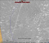
The heading is consistent with the next crater on the planned route. Here's it on Google Earth.
|
|
|
|
|
|
|
Feb 6 2010, 01:04 PM
Post
#70
|
||
|
The Poet Dude Group: Moderator Posts: 5551 Joined: 15-March 04 From: Kendal, Cumbria, UK Member No.: 60 |
Wow, we've only just got here and we can already see where we're going next!
-------------------- |
|
|
|
|
|
|
Feb 6 2010, 01:21 PM
Post
#71
|
||
|
The Poet Dude Group: Moderator Posts: 5551 Joined: 15-March 04 From: Kendal, Cumbria, UK Member No.: 60 |
Concepcion and the Next Crater, seen at same scale, with the IAS viewer...
-------------------- |
|
|
|
|
|
|
Feb 6 2010, 04:03 PM
Post
#72
|
|
|
Special Cookie Group: Members Posts: 2168 Joined: 6-April 05 From: Sintra | Portugal Member No.: 228 |
QUOTE (Stu @ Feb 6 2010, 01:21 PM) Concepcion and the Next Crater, seen at same scale, with the IAS viewer... Can't resist...stop me please...  I hereby name you...Double Dare! Aliki & Margot...
-------------------- "Ride, boldly ride," The shade replied, "If you seek for Eldorado!"
Edgar Alan Poe |
|
|
|
|
Feb 6 2010, 04:22 PM
Post
#73
|
|||||
|
Member Group: Members Posts: 713 Joined: 30-March 05 Member No.: 223 |
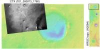
As long as there is no HiRISE DEM yet ... here is a quick try at creating a single-image-DEM from the CTX image T01_000873_1780_XI_02S005W.
(with the whole DEM consisting of about 10 million polygons which is currently about the limit that my software's core math solvers can handle. So the next project I'm working on is to port and compile my sources into a true 64-bit application such that it can make use of the full 12 GB main memory under Vista 64 (I know, I know I should use a Mac, really -> so maybe in the near future it will be able to generate DEMs with 50-100 million polygons.some oblique views of the area between Victoria and Endeavour:
And the last image is how it might look like from the ground. However, I did not select a special viewing direction ... just played around with the camera position and rotation until it looked good ... ah yes, and the vertical height is somewhat exaggerated too

|
||||
|
|
|
||||
|
Feb 6 2010, 04:40 PM
Post
#74
|
|
|
Member Group: Members Posts: 877 Joined: 7-March 05 From: Switzerland Member No.: 186 |
Just at that twin crater we might get a better view to the south(west), i.e a sign of Bopulu crater and the hills eastward of its "promontory".
Oh my, very nice...good stuff, Nirgal!
-------------------- |
|
|
|
|
Feb 6 2010, 06:10 PM
Post
#75
|
||
|
Senior Member Group: Members Posts: 4247 Joined: 17-January 05 Member No.: 152 |
QUOTE (Tesheiner @ Feb 6 2010, 01:37 PM) The heading is consistent with the next crater on the planned route. Early in this thread I suggested based on the navcams that this feature to the south was the hill far to the south. I agree it looks much too close to be that hill, which is farther than Iazu. But I'm not sure about your identification, Tesheiner. I'll call the close pair of craters you suggested Twin Craters (I guess they're not identical twins!). Measuring the angles each component (A and B ) would subtend at Conception, I find the Twins should look this big:
In other words, much bigger than the dark feature on the horizon. But looking closely, there are some dark features (black arrows) that could perhaps be one or both of Twin Craters somewhat closer than the horizon. In L2, these features look bright, which might be exposed bedrock on the rims? Is there another feature somewhat farther than Twin Craters that the dark feature on the horizon could be? |
|
|
|
|
|
|
Feb 6 2010, 07:10 PM
Post
#76
|
|
|
Senior Member Group: Members Posts: 3516 Joined: 4-November 05 From: North Wales Member No.: 542 |
I've been pondering these features, the farther and the nearer, for the last few hours but without having your handle on the subtended sizes. I believed Tesheiner (as one does
) but then couldn't find anything on Stu's Hirise crop that looked like the nearer features. Then again like Tman I thought the downward slope would be starting about where the twin craters are, so wouldn't have expected the ground to rise again immediately beyond. I can't be much use here but I'll stay closely tuned to learn how it pans out.
|
|
|
|
|
Feb 6 2010, 07:25 PM
Post
#77
|
|
|
Senior Member Group: Moderator Posts: 4279 Joined: 19-April 05 From: .br at .es Member No.: 253 |
We will certainly have to keep an eye on those features once we leave this area.
Fredk is right. Althought the horizon feature is at the right heading, it's too small to be the twin craters; those ones, combined, cover about 3.5º viewed from the current position, while the black feature has only 0.4º. QUOTE (fredk @ Feb 6 2010, 07:10 PM) Is there another feature somewhat farther than Twin Craters that the dark feature on the horizon could be? Unfortunately, the HiRISE picture I'm using doesn't cover that area. |
|
|
|
|
Feb 6 2010, 08:02 PM
Post
#78
|
||
|
Solar System Cartographer Group: Members Posts: 10166 Joined: 5-April 05 From: Canada Member No.: 227 |
Here's a crater in about the right place.
Phil
-------------------- ... because the Solar System ain't gonna map itself.
Also to be found posting similar content on https://mastodon.social/@PhilStooke Maps for download (free PD: https://upload.wikimedia.org/wikipedia/comm...Cartography.pdf NOTE: everything created by me which I post on UMSF is considered to be in the public domain (NOT CC, public domain) |
|
|
|
|
|
|
Feb 6 2010, 08:10 PM
Post
#79
|
|
|
Senior Member Group: Members Posts: 3516 Joined: 4-November 05 From: North Wales Member No.: 542 |
That looks highly plausible Phil. How far away is that? Is it on our projected route?
|
|
|
|
|
Feb 6 2010, 08:18 PM
Post
#80
|
||
|
Solar System Cartographer Group: Members Posts: 10166 Joined: 5-April 05 From: Canada Member No.: 227 |
It is about where we start to turn to the east after this long trek south and west (about 1400 m south of Concepcion).
Meanwhile, here is another look at Iazu, a comparison of two sols (cut from a post higher up in this thread). I have labelled four hills, and the way hill D gets displaced relative to the other three suggests it must be on the far rim of Iazu. Phil
-------------------- ... because the Solar System ain't gonna map itself.
Also to be found posting similar content on https://mastodon.social/@PhilStooke Maps for download (free PD: https://upload.wikimedia.org/wikipedia/comm...Cartography.pdf NOTE: everything created by me which I post on UMSF is considered to be in the public domain (NOT CC, public domain) |
|
|
|
|
|
|
Feb 7 2010, 05:36 AM
Post
#81
|
|
|
Merciless Robot Group: Admin Posts: 8784 Joined: 8-December 05 From: Los Angeles Member No.: 602 |
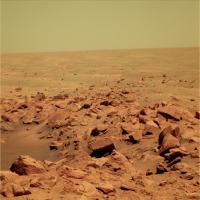
Stu's latest pic (which is a wow!) made me realize something that is stunningly obvious, but bears reflection: All of the geology @ Meridiani is completely buried. It take an impact to bring anything at all up above the sand. This is strikingly different from the other locales on Mars we've been able to see at this scale.
Why? -------------------- A few will take this knowledge and use this power of a dream realized as a force for change, an impetus for further discovery to make less ancient dreams real.
|
|
|
|
|
Feb 7 2010, 08:42 PM
Post
#82
|
|
 Senior Member Group: Members Posts: 1229 Joined: 24-December 05 From: The blue one in between the yellow and red ones. Member No.: 618 |
The soft, sulfate sandstone surrounding us at the surface is swiftly and steadily sanded smooth in the short term.
The relatively resistant, robust rocks representing the rest retain the resplendent relief remaining from the remote realm of real rheology and resurfacing. Really
-------------------- My Grandpa goes to Mars every day and all I get are these lousy T-shirts!
|
|
|
|
|
Feb 7 2010, 08:53 PM
Post
#83
|
|
|
Merciless Robot Group: Admin Posts: 8784 Joined: 8-December 05 From: Los Angeles Member No.: 602 |
Oh, great. Now I gotta come up with a sentence featuring words that start with "Q"??!
Quiescent quiteus, queries quintessential (quixotically?) I quit! [EDIT: Quorrected!] -------------------- A few will take this knowledge and use this power of a dream realized as a force for change, an impetus for further discovery to make less ancient dreams real.
|
|
|
|
|
Feb 7 2010, 10:51 PM
Post
#84
|
|
|
Founder Group: Chairman Posts: 14432 Joined: 8-February 04 Member No.: 1 |
Quite.
|
|
|
|
|
Feb 7 2010, 11:05 PM
Post
#85
|
|
|
Junior Member Group: Members Posts: 71 Joined: 19-January 10 From: Grimsby, N.E. Lincs, UK Member No.: 5179 |
please...
|
|
|
|
|
Feb 8 2010, 01:05 AM
Post
#86
|
|
|
Merciless Robot Group: Admin Posts: 8784 Joined: 8-December 05 From: Los Angeles Member No.: 602 |
Damned if I didn't misspell "quintessential" to boot (Corrected...I hope!)! Argh. Gonna get the letter Q kicked out of the English language for good; I'll let you all know when it's done.
-------------------- A few will take this knowledge and use this power of a dream realized as a force for change, an impetus for further discovery to make less ancient dreams real.
|
|
|
|
|
Feb 8 2010, 01:17 AM
Post
#87
|
|
|
Senior Member Group: Admin Posts: 3108 Joined: 21-December 05 From: Canberra, Australia Member No.: 615 |
Please be kwik!
|
|
|
|
|
Feb 8 2010, 10:23 AM
Post
#88
|
|
|
Senior Member Group: Members Posts: 3516 Joined: 4-November 05 From: North Wales Member No.: 542 |
Now we are sicks?
http://images.google.com/imgres?imgurl=htt...t%3D40%26um%3D1 |
|
|
|
|
Feb 8 2010, 12:01 PM
Post
#89
|
|
|
Solar System Cartographer Group: Members Posts: 10166 Joined: 5-April 05 From: Canada Member No.: 227 |
"Gonna get the letter Q kicked out of the English language for good"
Finally, a use for those defective keyboards from Dilbert. Phil -------------------- ... because the Solar System ain't gonna map itself.
Also to be found posting similar content on https://mastodon.social/@PhilStooke Maps for download (free PD: https://upload.wikimedia.org/wikipedia/comm...Cartography.pdf NOTE: everything created by me which I post on UMSF is considered to be in the public domain (NOT CC, public domain) |
|
|
|
|
Feb 8 2010, 10:59 PM
Post
#90
|
|
|
Senior Member Group: Members Posts: 3516 Joined: 4-November 05 From: North Wales Member No.: 542 |
Referring to the crater that appears on the horizon beyond 'twin craters' - QUOTE (Phil Stooke @ Feb 6 2010, 08:18 PM) It is about where we start to turn to the east after this long trek south and west (about 1400 m south of Concepcion). I'm still not entirely making sense of this. Using the 800m diameter of Victoria for scale I reckon we turn east less than 1400 metres south of Concepcion. Also, 1400 metres south of Concepcion would place that horizon feature below the next (downward) contour on the map. I'm aware of the limitations of the map. So I still don't know if we're going to visit that crater or not, and I'm now additionally uncertain about where the opening up of the view to the S and SW can be expected. Can anybody shed light? |
|
|
|
|
Feb 8 2010, 11:25 PM
Post
#91
|
|
|
Senior Member Group: Members Posts: 4247 Joined: 17-January 05 Member No.: 152 |
Ngunn, using the proposed route we've seen from the abstract, I agree that we'd turn east before reaching the "crater beyond twin craters". But nothing stands out for that crater (it doesn't look especially fresh, eg), and I'm sure we'll encounter more similar sized ones on our trek. Of course we have to keep in mind that that's only a proposed route - we're not commited to it. Also the resolution of the proposed map isn't great.
In terms of the view, according to the contour map, the best views will be between the south and east. The rise around "crater beyond twin craters" is towards the SSW, so it shouldn't block our views towards the south to east. I don't know what kind of view we'll get to the SW (eg Bopolu), since I haven't seen a topo map in that direction. |
|
|
|
|
Feb 8 2010, 11:45 PM
Post
#92
|
||
|
Senior Member Group: Members Posts: 4247 Joined: 17-January 05 Member No.: 152 |
QUOTE (Phil Stooke @ Feb 6 2010, 09:18 PM) Meanwhile, here is another look at Iazu... I have labelled four hills, and the way hill D gets displaced relative to the other three suggests it must be on the far rim of Iazu. I agree D is on the far rim, and in this post I also claimed that the bits on the right are far rim. Here's a cross-eyed version of the long baseline stereo view for those red-green challanged out there:
|
|
|
|
|
|
|
Feb 9 2010, 04:02 AM
Post
#93
|
|
|
Solar System Cartographer Group: Members Posts: 10166 Joined: 5-April 05 From: Canada Member No.: 227 |
Right, I must have missed that! Very good. That far rim topography is the most distant we can see so far, I assume.
Phil -------------------- ... because the Solar System ain't gonna map itself.
Also to be found posting similar content on https://mastodon.social/@PhilStooke Maps for download (free PD: https://upload.wikimedia.org/wikipedia/comm...Cartography.pdf NOTE: everything created by me which I post on UMSF is considered to be in the public domain (NOT CC, public domain) |
|
|
|
|
Feb 12 2010, 02:52 PM
Post
#94
|
|
|
Senior Member Group: Members Posts: 3516 Joined: 4-November 05 From: North Wales Member No.: 542 |
What's that on the right?
http://qt.exploratorium.edu/mars/opportuni...66P2368L7M1.JPG |
|
|
|
|
Feb 12 2010, 03:42 PM
Post
#95
|
|
|
Merciless Robot Group: Admin Posts: 8784 Joined: 8-December 05 From: Los Angeles Member No.: 602 |
Could you be more specific? Nothing jumps out at me.
-------------------- A few will take this knowledge and use this power of a dream realized as a force for change, an impetus for further discovery to make less ancient dreams real.
|
|
|
|
|
Feb 12 2010, 03:54 PM
Post
#96
|
||
|
Senior Member Group: Members Posts: 2173 Joined: 28-December 04 From: Florida, USA Member No.: 132 |
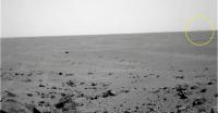
QUOTE (nprev @ Feb 12 2010, 10:42 AM) Could you be more specific? Nothing jumps out at me. Maybe he's referring to that faint rise on the horizon.
|
|
|
|
|
|
|
Feb 12 2010, 03:58 PM
Post
#97
|
|
|
Senior Member Group: Members Posts: 3516 Joined: 4-November 05 From: North Wales Member No.: 542 |
There appears to be a hill on the horizon extending in from the right margin for about 10 percent of the image width. It's visible in 2 of the 3 filters.
EDIT: You got it centsworth. Looks like I'll just miss the answer - I'm off for a week's holiday now. |
|
|
|
|
Feb 12 2010, 04:05 PM
Post
#98
|
||
 Senior Member Group: Members Posts: 1088 Joined: 19-February 05 From: Close to Meudon Observatory in France Member No.: 172 |
QUOTE (nprev @ Feb 12 2010, 04:42 PM) Could you be more specific? Nothing jumps out at me. Thanks ngunn. Feature noticed also... Enjoy the enhancement
|
|
|
|
|
|
|
Feb 12 2010, 04:33 PM
Post
#99
|
|
|
Solar System Cartographer Group: Members Posts: 10166 Joined: 5-April 05 From: Canada Member No.: 227 |
Comparing this with the circular pan from the other thread, this lies in the right direction to be Bopolu crater.
Phil -------------------- ... because the Solar System ain't gonna map itself.
Also to be found posting similar content on https://mastodon.social/@PhilStooke Maps for download (free PD: https://upload.wikimedia.org/wikipedia/comm...Cartography.pdf NOTE: everything created by me which I post on UMSF is considered to be in the public domain (NOT CC, public domain) |
|
|
|
|
Feb 12 2010, 09:04 PM
Post
#100
|
|
|
Senior Member Group: Members Posts: 4247 Joined: 17-January 05 Member No.: 152 |
Here's my attempt at pulling Bopolu out of the haze and jpeg noise. Average of L5 and L7, contrast and 3x vertical stretches:
[attachment=20701:Bopolu_sol2140.jpg] Bopolu in its entirety would subtend around 18 degrees for Oppy, while this bit's only about 2 degrees wide. So presumably we're seeing just one high part of the rim now. |
|
|
|
|

|
Lo-Fi Version | Time is now: 23rd May 2024 - 01:04 PM |
|
RULES AND GUIDELINES Please read the Forum Rules and Guidelines before posting. IMAGE COPYRIGHT |
OPINIONS AND MODERATION Opinions expressed on UnmannedSpaceflight.com are those of the individual posters and do not necessarily reflect the opinions of UnmannedSpaceflight.com or The Planetary Society. The all-volunteer UnmannedSpaceflight.com moderation team is wholly independent of The Planetary Society. The Planetary Society has no influence over decisions made by the UnmannedSpaceflight.com moderators. |
SUPPORT THE FORUM Unmannedspaceflight.com is funded by the Planetary Society. Please consider supporting our work and many other projects by donating to the Society or becoming a member. |
|