Lakes in the limelight, the 2013 image bonanza continues |

  |
Lakes in the limelight, the 2013 image bonanza continues |
 Sep 13 2013, 02:20 PM Sep 13 2013, 02:20 PM
Post
#1
|
|
|
Senior Member  Group: Members Posts: 3516 Joined: 4-November 05 From: North Wales Member No.: 542 |
A fantastic collection of new images of the northern lakes has just arrived: http://saturn.jpl.nasa.gov/photos/raw/rawi...?imageID=298704
|
 |
 
|
|
Sep 13 2013, 03:12 PM
Post
#2
|
||
|
Member Group: Members Posts: 701 Joined: 1-April 08 From: Minnesota ! Member No.: 4081 |
Very cool raw images indeed !!
|
|
|
|
|
|
|
Sep 13 2013, 03:13 PM
Post
#3
|
||
|
Solar System Cartographer Group: Members Posts: 10184 Joined: 5-April 05 From: Canada Member No.: 227 |
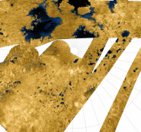
Wow, they are great. This is one with a bit of a stretch and cleanup.
Phil
-------------------- ... because the Solar System ain't gonna map itself.
Also to be found posting similar content on https://mastodon.social/@PhilStooke Maps for download (free PD: https://upload.wikimedia.org/wikipedia/comm...Cartography.pdf NOTE: everything created by me which I post on UMSF is considered to be in the public domain (NOT CC, public domain) |
|
|
|
|
|
|
Sep 13 2013, 04:10 PM
Post
#4
|
|
 Senior Member Group: Moderator Posts: 3233 Joined: 11-February 04 From: Tucson, AZ Member No.: 23 |
Wow, looks like I'll be busy for a while...
Still sorting through the images myself.... This looks like a great image of Sparrow Lacus http://saturn.jpl.nasa.gov/photos/raw/rawi...?imageID=298793 -------------------- &@^^!% Jim! I'm a geologist, not a physicist!
The Gish Bar Times - A Blog all about Jupiter's Moon Io |
|
|
|
|
Sep 13 2013, 09:46 PM
Post
#5
|
||
 Lord Of The Uranian Rings Group: Members Posts: 798 Joined: 18-July 05 From: Plymouth, UK Member No.: 437 |
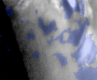
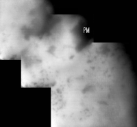
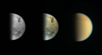
Three-frame WAC mosaic of Titan's northern wetlands, with a *tentative* identification of PUNGA MARE labelled as 'PM'.
-------------------- |
|
|
|
|
|
|
Sep 13 2013, 11:04 PM
Post
#6
|
|
|
Senior Member Group: Members Posts: 1585 Joined: 14-October 05 From: Vermont Member No.: 530 |
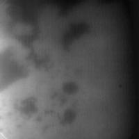
Is any high-contrast spot safely assumed to be a lake?
|
|
|
|
|
Sep 14 2013, 11:31 AM
Post
#7
|
|
|
Lord Of The Uranian Rings Group: Members Posts: 798 Joined: 18-July 05 From: Plymouth, UK Member No.: 437 |
At this latitude, I think that's a fairly safe assumption.
-------------------- |
|
|
|
|
Sep 14 2013, 11:38 AM
Post
#8
|
|
|
Senior Member Group: Members Posts: 3516 Joined: 4-November 05 From: North Wales Member No.: 542 |
Recalling the south polar views from a few years back there is also the possibility of temporary dark patches resulting from recent rain.
(BTW does anybody know if recent lake imaging includes any shots through polarising filters? My sporadic searches have not turned up any.) |
|
|
|
|
Sep 14 2013, 02:59 PM
Post
#9
|
||
|
Lord Of The Uranian Rings Group: Members Posts: 798 Joined: 18-July 05 From: Plymouth, UK Member No.: 437 |
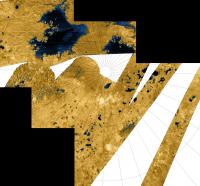
The same region of Titan's north pole, as seen by radar (cropped from PIA10008):
-------------------- |
|
|
|
|
|
|
Sep 14 2013, 03:02 PM
Post
#10
|
||
|
Lord Of The Uranian Rings Group: Members Posts: 798 Joined: 18-July 05 From: Plymouth, UK Member No.: 437 |
Blink GIF version:
-------------------- |
|
|
|
|
|
|
Sep 14 2013, 03:35 PM
Post
#11
|
|
|
Lord Of The Uranian Rings Group: Members Posts: 798 Joined: 18-July 05 From: Plymouth, UK Member No.: 437 |
-------------------- |
|
|
|
|
Sep 14 2013, 08:43 PM
Post
#12
|
|
|
Senior Member Group: Members Posts: 3516 Joined: 4-November 05 From: North Wales Member No.: 542 |
Nice mosaic and great overlay. There are some interesting differencences from the SAR view.
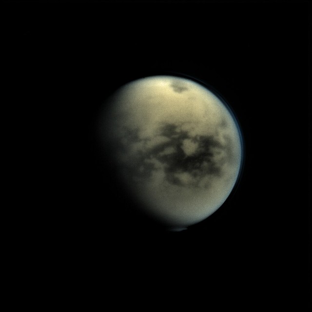
Here is an image from a few days earlier that I like because it shows almost the whole of Titan's northern lake province now in daylight. (It's one of many that are ripe for stacking and other clever stuff.) http://saturn.jpl.nasa.gov/multimedia/imag...0/N00216700.jpg |
|
|
|
|
Sep 14 2013, 09:30 PM
Post
#13
|
|
 Senior Member Group: Moderator Posts: 2785 Joined: 10-November 06 From: Pasadena, CA Member No.: 1345 |
QUOTE (Ian R @ Sep 14 2013, 07:31 AM)  At this latitude, I think that's a fairly safe assumption. There are no safe assumptions on Titan. -------------------- Some higher resolution images available at my photostream: http://www.flickr.com/photos/31678681@N07/
|
|
|
|
|
Sep 14 2013, 11:02 PM
Post
#14
|
|
|
Member Group: Members Posts: 315 Joined: 1-October 06 Member No.: 1206 |
QUOTE (Juramike @ Sep 15 2013, 08:00 AM) There are no safe assumptions on Titan. Looks like its been raining up there!  P |
|
|
|
|
Sep 15 2013, 02:24 AM
Post
#15
|
|
|
Lord Of The Uranian Rings Group: Members Posts: 798 Joined: 18-July 05 From: Plymouth, UK Member No.: 437 |
QUOTE (Juramike @ Sep 14 2013, 10:30 PM) There are no safe assumptions on Titan. True, true: but I still think it's fairly safe to say the dark splodges are more likely to be fluid-related than anything else. -------------------- |
|
|
|
|
Sep 24 2013, 07:46 AM
Post
#16
|
|||
|
Member Group: Members Posts: 701 Joined: 1-April 08 From: Minnesota ! Member No.: 4081 |
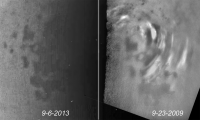
"Here is an image from a few days earlier that I like because it shows almost the whole of Titan's northern lake province now in daylight. (It's one of many that are ripe for stacking and other clever stuff.)"
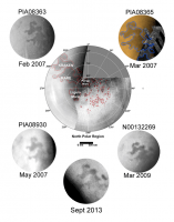
Agree the earlier views of the N polar lakes are striking. The September 6th images stand in stark contrast to those of Sept 2009 when plenty of tropospheric clouds appeared over the N polar lakes and seas (figure on left). The apparent lack of clouds raise questions as to 1) whether the clouds are seasonal-atmospheric phenomena and not much influenced by the lakes presence or 2) whether the lake/sea composition and minimal seasonal winds at this time are less conducive for cloud formation. The color composite images and the upper haze layers (seen in the UV3 filter) are also awesome (figure on the right).
|
||
|
|
|
||
|
Sep 26 2013, 06:11 PM
Post
#17
|
|
|
Senior Member Group: Members Posts: 3516 Joined: 4-November 05 From: North Wales Member No.: 542 |
One late arrival - some smallish lakes from fairly close in. Is that MacKay lacus at the bottom left?
http://saturn.jpl.nasa.gov/multimedia/imag...0/N00217222.jpg |
|
|
|
|
Oct 15 2013, 09:55 PM
Post
#18
|
|
|
Senior Member Group: Members Posts: 3516 Joined: 4-November 05 From: North Wales Member No.: 542 |
Another family portrait of Titan's great lakes, clockwise from top: Kraken, Jingpo, Punga, Ligeia.
http://saturn.jpl.nasa.gov/multimedia/imag...0/N00217414.jpg |
|
|
|
|
Oct 16 2013, 08:06 PM
Post
#19
|
||
|
Lord Of The Uranian Rings Group: Members Posts: 798 Joined: 18-July 05 From: Plymouth, UK Member No.: 437 |
-------------------- |
|
|
|
|
|
|
Oct 16 2013, 09:04 PM
Post
#20
|
|
|
Senior Member Group: Members Posts: 3516 Joined: 4-November 05 From: North Wales Member No.: 542 |
Beautiful! I was really hoping someone would do that, so my hearty thanks.
 There's one area in these new views that I'm finding hard to reconcile with the earlier ISS views of the lakes. It's the area on the eastern side of Kraken Mare that in the first images resembled the foot of Italy. Looking at it now Italy appears to have curled up its toe! Here's the older view: http://upload.wikimedia.org/wikipedia/comm...Kraken_mare.jpg |
|
|
|
|
Oct 23 2013, 02:04 AM
Post
#21
|
||
|
Member Group: Members Posts: 701 Joined: 1-April 08 From: Minnesota ! Member No.: 4081 |
I've added a Sept 2013 image (bottom of composite figure below) of Kraken. The "toe of Italy" is about the same stage of 'falling off' as best I can tell and there hasn't been major changes from 2007. Perhaps with the ground surrounding the lake and seas saturated with methane and/or ethane http://www.newscientist.com/article/dn2443...s-on-titan.html big changes are not expected.
|
|
|
|
|
|
|
Oct 23 2013, 12:48 PM
Post
#22
|
||
|
Senior Member Group: Members Posts: 3516 Joined: 4-November 05 From: North Wales Member No.: 542 |
My clumsy atempt to highlight what I was referring to on a crop from Ian R's mosaic. 'Toe' is the upper oval. Lower oval is the dark area I don't see on the earlier images.
EDIT: still trying to attach . . aah, there we go:
Attached thumbnail(s)
|
|
|
|
|
|
|
Oct 23 2013, 07:25 PM
Post
#23
|
|
|
Senior Member Group: Moderator Posts: 3233 Joined: 11-February 04 From: Tucson, AZ Member No.: 23 |
I can finally show off our versions of these mosaics:
T92 MONITORNA001: http://www.ciclops.org/view/7730/Dark-Lake...right-Landscape T93 MONITORNA001: http://www.ciclops.org/view/7731/Titans-No...The-Big-Picture T94 REGMAP001: http://www.ciclops.org/view/7732/Birds-Eye...e-Land-of-Lakes T94 VIMS HIRES: http://www.ciclops.org/view/7733/Titans-No...akes-Salt-Flats -------------------- &@^^!% Jim! I'm a geologist, not a physicist!
The Gish Bar Times - A Blog all about Jupiter's Moon Io |
|
|
|
|
Oct 23 2013, 09:14 PM
Post
#24
|
|
|
Senior Member Group: Members Posts: 3516 Joined: 4-November 05 From: North Wales Member No.: 542 |
What a bountiful harvest of wonderful views!!! There is unprecedented detail (I think) in the ISS products and the spectacular VIMS release is particularly welcome. We had evidence of a light fringe around Kraken Mare before but now we see the full extent of these possible evaporite deposits. I'm a bit surprised that the greenish background on the VIMS mosaic is described as water ice. I thought exposed water ice was rather rare on Titan.
|
|
|
|
|
Oct 23 2013, 09:22 PM
Post
#25
|
|
 Administrator Group: Admin Posts: 5172 Joined: 4-August 05 From: Pasadena, CA, USA, Earth Member No.: 454 |
I think I had a conversation with somebody about that at DPS -- that there's a new calibration of VIMS data that has changed the apparent relative brightness of the surface in two windows that suddenly make water ice a possibility for that surface. I think. I better go check that with somebody. Is Jason Barnes still hanging around here?
-------------------- My website - My Patreon - @elakdawalla on Twitter - Please support unmannedspaceflight.com by donating here.
|
|
|
|
|
Oct 23 2013, 09:34 PM
Post
#26
|
|
|
Senior Member Group: Members Posts: 3516 Joined: 4-November 05 From: North Wales Member No.: 542 |
Such a reinterpretation would make sense. I think the Huygens team has always maintained that the pebbles on the surface are probably water ice. It would be good to know, one way or the other.
|
|
|
|
|
Oct 23 2013, 09:36 PM
Post
#27
|
|
|
Lord Of The Uranian Rings Group: Members Posts: 798 Joined: 18-July 05 From: Plymouth, UK Member No.: 437 |
Fantastic work Jason!

-------------------- |
|
|
|
|
Oct 23 2013, 10:00 PM
Post
#28
|
|
 Member Group: Members Posts: 131 Joined: 30-August 06 From: Moscow, Idaho Member No.: 1086 |
QUOTE (elakdawalla @ Oct 23 2013, 02:22 PM) I think I had a conversation with somebody about that at DPS -- that there's a new calibration of VIMS data that has changed the apparent relative brightness of the surface in two windows that suddenly make water ice a possibility for that surface. I think. I better go check that with somebody. Is Jason Barnes still hanging around here? I've been lurking recently, but I show up every once in a while  The greenish stuff is probably more icy than the evaporites, for sure, but isn't pure water ice, even with the 2.7/2.8 micron correction that I talked about at DPS. But it's got SOME ice, while the evaporites have none. Note that the press release was simplified from what I would have written; I don't get to have them be rigorous enough for this crowd always The greenish stuff is probably more icy than the evaporites, for sure, but isn't pure water ice, even with the 2.7/2.8 micron correction that I talked about at DPS. But it's got SOME ice, while the evaporites have none. Note that the press release was simplified from what I would have written; I don't get to have them be rigorous enough for this crowd always - VIMS Jason |
|
|
|
|
Oct 24 2013, 06:21 PM
Post
#29
|
|
|
Rover Driver Group: Members Posts: 1015 Joined: 4-March 04 Member No.: 47 |
There was an interesting talk by Pascal Rannou at EPSC ( http://meetingorganizer.copernicus.org/EPS...PSC2013-459.pdf - although the abstract doesn't mention results yet), showing a very nice fit to the DISR data with a combination of water ice and fractal haze particles. Apparently it shows a water ice feature at 1.5 micron.
|
|
|
|
|
Oct 24 2013, 07:45 PM
Post
#30
|
|
|
Member Group: Members Posts: 131 Joined: 30-August 06 From: Moscow, Idaho Member No.: 1086 |
QUOTE (Jason W Barnes @ Oct 23 2013, 03:00 PM) The greenish stuff is probably more icy than the evaporites, for sure, but isn't pure water ice, even with the 2.7/2.8 micron correction that I talked about at DPS. Speaking of which, the paper associated with that talk is just now out in ApJ, here's a link to the copy on my website. - VIMS Jason |
|
|
|
|
Oct 24 2013, 09:20 PM
Post
#31
|
|
|
Senior Member Group: Members Posts: 3516 Joined: 4-November 05 From: North Wales Member No.: 542 |
A joy to read; thanks very much as ever for making your paper availalable to all. What it says about the presence of water ice on the surface of Titan is a tiny part of a paper that has so much more in it, but it's the sort of nugget that is much appreciated here.
|
|
|
|
|
Oct 26 2013, 04:33 AM
Post
#32
|
|
 Member Group: Members Posts: 611 Joined: 23-February 07 From: Occasionally in Columbia, MD Member No.: 1764 |
QUOTE (remcook @ Oct 24 2013, 02:21 PM) There was an interesting talk by Pascal Rannou at EPSC ..... showing a very nice fit to the DISR data with a combination of water ice and fractal haze particles. Apparently it shows a water ice feature at 1.5 micron. Awesome. 20 years ago we were grappling with disk-integrated groundbased spectroscopy, and the best fit people could come up with was 'dirty ice'. And now, after much debate on Huygens/DISR and Cassini/VIMS, we discover.....dirty ice. This is getting as bad as water on Mars..... |
|
|
|
|
Oct 26 2013, 10:04 PM
Post
#33
|
|
|
Senior Member Group: Members Posts: 1585 Joined: 14-October 05 From: Vermont Member No.: 530 |
QUOTE (rlorenz @ Oct 26 2013, 12:33 AM) Awesome. 20 years ago we were grappling with disk-integrated groundbased spectroscopy, and the best fit people could come up with was 'dirty ice'. And now, after much debate on Huygens/DISR and Cassini/VIMS, we discover.....dirty ice. This is getting as bad as water on Mars..... For any poorly constrained yet hugely significant question in planetary science, there will be an endless series of releases answering various better-constrained versions of that question. See also, Voyager, exiting solar system. Or earthlike planet, discovered. |
|
|
|
|
Oct 26 2013, 10:48 PM
Post
#34
|
|
|
Senior Member Group: Members Posts: 2090 Joined: 13-February 10 From: Ontario Member No.: 5221 |
There was controversy about what material Huygens pebbles were made of? Wasn't water ice the obvious explanation right from the start? Obviously confirmation is important news but what other material could they have been?
I remember reading it in the thread in this very sub-forum as the images came down. Good times... |
|
|
|
|
Oct 27 2013, 10:30 AM
Post
#35
|
|
|
Senior Member Group: Members Posts: 3516 Joined: 4-November 05 From: North Wales Member No.: 542 |
QUOTE (Explorer1 @ Oct 26 2013, 11:48 PM) what other material could they have been? Take your pick from a wide range of waxy or soapy organics (evaporites?). We were staring at them but we just didn't know - and truth to tell we still don't, even if water ice now seems increasingly likely. |
|
|
|
|
Oct 31 2013, 04:43 AM
Post
#36
|
|
|
Senior Member Group: Moderator Posts: 2785 Joined: 10-November 06 From: Pasadena, CA Member No.: 1345 |
The effective dielectric constant data over most of Titan, including the Huygens landing site, is not consistent with water ice. (Janssen, 2010)
Spectral measurements only look at the top few microns of paint. RADAR probes deeper. +Mike -------------------- Some higher resolution images available at my photostream: http://www.flickr.com/photos/31678681@N07/
|
|
|
|
|
Aug 9 2014, 09:57 PM
Post
#37
|
|
|
Senior Member Group: Members Posts: 3516 Joined: 4-November 05 From: North Wales Member No.: 542 |
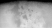
I've been busy with house and family and missed this when it came out. It's a particularly clear view of Titan's lake district:
http://saturn.jpl.nasa.gov/multimedia/imag...4/N00227079.jpg Apart from enjoying the whole picture I notice there is a bright streak across the middle of Ligeia Mare. Is it a patch of cloud, or something to do with the 'magic island' recently reported off one of Ligeia's headlands? |
|
|
|
|
Aug 10 2014, 01:04 AM
Post
#38
|
|
|
Senior Member Group: Moderator Posts: 3233 Joined: 11-February 04 From: Tucson, AZ Member No.: 23 |
Those are clouds.
-------------------- &@^^!% Jim! I'm a geologist, not a physicist!
The Gish Bar Times - A Blog all about Jupiter's Moon Io |
|
|
|
|
Aug 10 2014, 02:42 AM
Post
#39
|
|
|
Administrator Group: Admin Posts: 5172 Joined: 4-August 05 From: Pasadena, CA, USA, Earth Member No.: 454 |
Forgive me if I'm out of touch, but: Jason, haven't you been looking for clouds for, like, a long time? Is this a big deal?
-------------------- My website - My Patreon - @elakdawalla on Twitter - Please support unmannedspaceflight.com by donating here.
|
|
|
|
|
Aug 12 2014, 07:38 PM
Post
#40
|
|
|
Member Group: Members Posts: 813 Joined: 29-December 05 From: NE Oh, USA Member No.: 627 |
Cassini press release
Cassini Tracks Clouds Developing Over a Titan Sea http://saturn.jpl.nasa.gov/news/newsreleas...elease20140812/ CICLOPS site http://ciclops.org/view/7929/Clouds-Over-L...e-on-Titan?js=1 |
|
|
|
|
Aug 12 2014, 09:01 PM
Post
#41
|
|
|
Senior Member Group: Moderator Posts: 3233 Joined: 11-February 04 From: Tucson, AZ Member No.: 23 |
Hmm, well, I guess I can talk about this now. Yes, we have been looking for clouds for a while and not seeing them. And yes this is kind of a big deal.
-------------------- &@^^!% Jim! I'm a geologist, not a physicist!
The Gish Bar Times - A Blog all about Jupiter's Moon Io |
|
|
|
|
Aug 13 2014, 09:25 AM
Post
#42
|
|
|
Member Group: Members Posts: 315 Joined: 1-October 06 Member No.: 1206 |
Is this a 'lake effect'? Is there much of a difference between the liquid and the overlying atmosphere?
P |
|
|
|
|
Aug 13 2014, 12:23 PM
Post
#43
|
|
|
Forum Contributor Group: Members Posts: 1372 Joined: 8-February 04 From: North East Florida, USA. Member No.: 11 |
For a weather nut like me, that is awesome
.
|
|
|
|
|
Aug 17 2014, 03:27 PM
Post
#44
|
||
|
Member Group: Members Posts: 701 Joined: 1-April 08 From: Minnesota ! Member No.: 4081 |
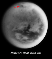
Yes, awesome observations and imaging! From Rev 207 http://www.ciclops.org/view/7921/Rev207 two CB3 images N00227321 and N00227310 taken on August 13th appear to show clouds in motion over Ligeia Mare and Muggel Lacus. (although spacecraft motion causes whole image shift and my less than ideal image processing may have me fooled!)
|
|
|
|
|
|
|
Aug 20 2014, 09:01 PM
Post
#45
|
|
|
Senior Member Group: Members Posts: 3516 Joined: 4-November 05 From: North Wales Member No.: 542 |
Well we've seen the first clouds for a while and measured their speed, now its time to hunt for the 'magic island', lake altimetry and depth sounding.
http://www.google.co.uk/url?sa=t&rct=j....73231344,d.ZGU Will the data from this flyby establish the relative surface altitudes of Ligeia nd Kraken? I'm not sure what is meant by Kraken Mare's estuary. Does that term refer to the channels that appear to link it with Ligeia or the ones around Mayda Insula? I note that the first convection clouds appeared over Ligeia, not Kraken. This would be consistent with Ligeia being relatively methane-rich and draining into Kraken; the latter acting as the less volatile ethane sump. |
|
|
|
|
Aug 21 2014, 01:54 AM
Post
#46
|
||
|
Member Group: Members Posts: 701 Joined: 1-April 08 From: Minnesota ! Member No.: 4081 |
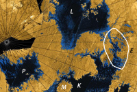
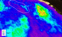
I presume this is the estuary (E) connecting Ligeia mare (L) and Kraken mare (K).
|
|
|
|
|
|
|
Aug 21 2014, 01:29 PM
Post
#47
|
|
|
Senior Member Group: Moderator Posts: 2785 Joined: 10-November 06 From: Pasadena, CA Member No.: 1345 |
Yup.
See: Sotin et al., Icarus 221 (2012) 768786. "Observations of Titans Northern lakes at 5[microns]: Implications for the organic cycle and geology". doi: 0.1016/j.icarus.2012.08.017. Freely available here: http://www.barnesos.net/publications/paper...thern.Lakes.pdf (Thanks to Jason Barnes for making this available on his webpage.) -------------------- Some higher resolution images available at my photostream: http://www.flickr.com/photos/31678681@N07/
|
|
|
|
|
Aug 21 2014, 10:07 PM
Post
#48
|
|
|
Senior Member Group: Members Posts: 3516 Joined: 4-November 05 From: North Wales Member No.: 542 |
Thanks for that confirmation of what is meant by 'the estuary'. Actually there seem to be quite a lot of estuaries draining into Kraken Mare, mostly at its northern end from what we've seen so far. The paper you refer to explicitly leaves as a significant open question the relative levels of Kraken and Ligeia, hence my interest in whether the current flyby science activities aim to address this.
|
|
|
|
|
Aug 22 2014, 09:23 PM
Post
#49
|
|
 Member Group: Members Posts: 754 Joined: 9-February 07 Member No.: 1700 |
When Cassini first arrived at Saturn, the release of Huygens was delayed (to get a better angle for comm relay, IIRC). I wondered why not delay it for many orbits so a landing site could be chosen based on the better info being obtained from numerous Titan flybys. Prudence favored releasing the lander as soon as possible.
A question for our Titan experts: if Cassini were still carrying Huygens today, where (and when) on Titan would you want to have it land? |
|
|
|
|
Aug 22 2014, 09:42 PM
Post
#50
|
|
|
Senior Member Group: Members Posts: 3516 Joined: 4-November 05 From: North Wales Member No.: 542 |
QUOTE (brellis @ Aug 22 2014, 10:23 PM) if Cassini were still carrying Huygens today, where (and when) on Titan would you want to have it land? (No expert, but I do have opinions . )I'm really glad nobody had the chance to choose the site. It landed with exceptional good fortune in a very information-rich location which would never in a month of Sundays have been selected by cautious planners. But yes: now we know what we know, and what we know is we badly need a robotic chemist in one of the lakes. Huygens was designed to cope with a lake landing but it wouldn't have done much chemistry. |
|
|
|
|
Aug 23 2014, 06:59 AM
Post
#51
|
|
|
Senior Member Group: Members Posts: 3516 Joined: 4-November 05 From: North Wales Member No.: 542 |
At first sight there appears to be a line of cloud in much the same place as before in this new image (on the far right just above Ligeia Lacus): http://saturn.jpl.nasa.gov/multimedia/imag...5/N00228346.jpg
|
|
|
|
|
Aug 23 2014, 04:03 PM
Post
#52
|
||
|
Lord Of The Uranian Rings Group: Members Posts: 798 Joined: 18-July 05 From: Plymouth, UK Member No.: 437 |
Yep, there seems to be a cloud right between Muggel and Ligeia, alright.
-------------------- |
|
|
|
|
|
|
Sep 1 2014, 12:36 AM
Post
#53
|
|
|
Member Group: Members Posts: 611 Joined: 23-February 07 From: Occasionally in Columbia, MD Member No.: 1764 |
QUOTE (ngunn @ Aug 22 2014, 04:42 PM) I'm really glad nobody had the chance to choose the site. It landed with exceptional good fortune in a very information-rich location which would never in a month of Sundays have been selected by cautious planners..... Huygens was designed to cope with a lake landing but it wouldn't have done much chemistry. Yes, and no. The entry point was determined by a number of engineering factors (entry angle tolerable by heat shield defines a circle, given the delivery asymptote). Solar illumination for the descent spectral measurements, and communications geometry (including having the line of sight mostly east-west for doppler wind measurements) were also constraints. These determined a small entry region around 145W 20N. This site was targeted by VIMS on the first Titan flyby (and hence had the first Nature paper written about it). The feature that happened to be at that spot, now named Tortola Facula, although I nicknamed it the 'cat poo', was possibly overinterpreted as a cryovolcanic construct - I think observations since do not lend much support to that interpretation. When the Huygens mission had to be redesigned following the receiver design flaw discovered on the Earth flyby in 1999, the new delivery scenario actually relieved some of the communications constraints on the delivery point, and we actually had a choice of 2 sites (and now, circa 2002 IIRC, crude maps to think about) at 190W and 10 North or South. We actually discussed it and South won, because it was the border between near-IR (940nm) bright and dark stuff. 940nm data, even at this point, don't really discriminate photometrically between dunes and seas, and no-one really expected the former! (By this time the observation planning had moved to later in the tour, and the VIMS targeting of the old landing site remained unchanged..) Anyway, had the probe landed in a liquid, it might well have capsized depending on the wind (the payload was indeed designed mostly with a liquid landing in mind, but the probe itself had no design requirements for any landing). The GCMS inlet was heated with the intent of volatilizing surface material, which indeed occurred in the damp regolith we landed in. So it might have been quite interesting chemistry-wise. Obviously, we might well aim for the seas now, although they might in fact be of quite different composition. Ligeia looks to be rather methane-rich ('fresh') while Kraken may be more solute-rich (analogous to the Baltic and the North Sea, or the Black Sea and the Mediterranean) - see http://www.lpl.arizona.edu/~rlorenz/flushing_preprint.pdf A sonar would probably work better in Ligeia, but from a chemistry standppoint Kraken might be the preferred choice. To understand the hydrological cycle you'd probably want a lander for each, or a vehicle that could somehow sample both...... Anyway, I take your point. If you want to survive a landing, a gullied streambed would likely not be the best choice. If we knew the surface, would we have aimed for the dunefields (as we did in the 2007 APL Titan Explorer Flagship Mission Study, before the seas had been mapped) ? Or the midlatitude blandlands? If we knew the seas were there, would we have targeted them - perhaps not - remember they were in winter darkness in 2005 ! Indeed where we ended up was information-rich - it certainly showed instantly that Titan was a hydrologically-shaped world. |
|
|
|
|
Sep 1 2014, 11:54 AM
Post
#54
|
|
|
Senior Member Group: Members Posts: 3516 Joined: 4-November 05 From: North Wales Member No.: 542 |
QUOTE (rlorenz @ Sep 1 2014, 01:36 AM) from a chemistry standppoint Kraken might be the preferred choice. Perhaps specifically the southern basin of Kraken given the drainage scheme you postulate there? I note that it lies partly outside Titan's arctic circle so would receive at least some sunlight even in midwinter. I don't know if the same can be said for the possibility of direct-to-earth communications |
|
|
|
|
Sep 1 2014, 01:40 PM
Post
#55
|
|
|
Member Group: Members Posts: 611 Joined: 23-February 07 From: Occasionally in Columbia, MD Member No.: 1764 |
QUOTE (ngunn @ Sep 1 2014, 07:54 AM) Perhaps specifically the southern basin of Kraken given the drainage scheme you postulate there? I note that it lies partly outside Titan's arctic circle so would receive at least some sunlight even in midwinter. I don't know if the same can be said for the possibility of direct-to-earth communications There it comes down to a 'how little data will you accept and how much risk of terrain obstruction' question. The usual story of contemporary planetary exploration - anything is possible, but how do you prove that there is no way, at all, ever, that it could possibly go wrong... Arguably at the extreme south of Kraken (ditto at Ontario) the material is more likely to be muddy/viscous, which makes landing dynamics and material sampling harder to test/verify (again, chances are everything would be fine, just costs a lot to demonstrate..) |
|
|
|
|
Sep 4 2014, 02:44 AM
Post
#56
|
|
|
Member Group: Members Posts: 701 Joined: 1-April 08 From: Minnesota ! Member No.: 4081 |
QUOTE (rlorenz @ Aug 31 2014, 06:36 PM) Obviously, we might well aim for the seas now, although they might in fact be of quite different composition. and this paper in Icarus http://www.jpl.nasa.gov/news/news.php?release=2014-294 might help explain sea composition differences if some seas are much older and therefore alkanofers and clathrate composition changes and interactions can influence extant sea composition. |
|
|
|
|
Sep 5 2014, 03:58 PM
Post
#57
|
||
|
Member Group: Members Posts: 701 Joined: 1-April 08 From: Minnesota ! Member No.: 4081 |
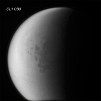
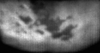
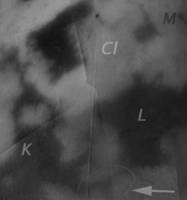
Below is NAC view (N00228357 from 256K km on 8-21-2014 CL1 CB3 filter) from the T104 flyby covering the Kraken (K) Ligeia (L) estuary. The cloudy region (Cl) between Muggel (M) and Ligeia is well shown, the estuary (arrow) just barely visible. The image shows the Looking Ahead ISS map (with a hint of radar) first and then the enhanced-cropped view of N00228357 fills in the right half of the scene.
|
|
|
|
|
|
|
Sep 16 2014, 01:19 AM
Post
#58
|
||
|
Member Group: Members Posts: 611 Joined: 23-February 07 From: Occasionally in Columbia, MD Member No.: 1764 |
QUOTE (titanicrivers @ Sep 5 2014, 10:58 AM) Below is NAC view (N00228357 from 256K km on 8-21-2014 CL1 CB3 filter) from the T104 flyby covering the Kraken (K) Ligeia (L) estuary.
The connection between Ligeia and Kraken may involve several parallel channels (hence I referred to it in my flushing paper as the Ligeia-Kraken Labyrinth, LKL) I'd say the Kraken inlet next one up from the labyrinth might be a better place for the label 'estuary'. (It was in this inlet that a radiometric change between T25 and T28 was observed, maybe suspended sediment?) |
|
|
|
|
|
|
Sep 30 2014, 05:08 PM
Post
#59
|
|
|
Senior Member Group: Members Posts: 3516 Joined: 4-November 05 From: North Wales Member No.: 542 |
The 'Magic Island' returns: http://photojournal.jpl.nasa.gov/catalog/PIA18430
|
|
|
|
|
Sep 30 2014, 09:41 PM
Post
#60
|
|
|
Member Group: Members Posts: 401 Joined: 5-January 07 From: Manchester England Member No.: 1563 |
I love mysteries, especially when their circumstances mandate that even the most mundane explanation will be extraordinary.....
-------------------- |
|
|
|
|
Sep 30 2014, 11:12 PM
Post
#61
|
|
 Member Group: Members Posts: 495 Joined: 12-February 12 Member No.: 6336 |
QUOTE (marsbug @ Sep 30 2014, 11:41 PM) I love mysteries, especially when their circumstances mandate that even the most mundane explanation will be extraordinary..... A mystery is always fun to poke the brain at. Considering the fact that ices will be heavier than the liquid on Titan, this might be the buildup of ice on a reef of ices right under the surface. The hypothesis that it might be foam is one I could have liked, but it is bright, which make that alternative less likely. |
|
|
|
|
Sep 30 2014, 11:54 PM
Post
#62
|
|
|
Senior Member Group: Members Posts: 3516 Joined: 4-November 05 From: North Wales Member No.: 542 |
Try solid ice-foam. Closed cell ice foam on the lake bed would be buoyant in methane. Either it could be formed currently by being erupted from the seabed in some cryovolcanic process or it could be there already just waiting for some disturbance to dislodge it so it can float up.
|
|
|
|
|
Oct 3 2014, 12:43 AM
Post
#63
|
|
|
Member Group: Members Posts: 495 Joined: 12-February 12 Member No.: 6336 |
QUOTE (ngunn @ Oct 1 2014, 01:54 AM) Try solid ice-foam. Closed cell ice foam on the lake bed would be buoyant in methane. Either it could be formed currently by being erupted from the seabed in some cryovolcanic process or it could be there already just waiting for some disturbance to dislodge it so it can float up. Solid ice-foam is a good suggestion, and I'd really like to get the idea to float. But the process would need to be just right to create foam bubbles of the right size and thickness to make all parts of this island buoyant. Now that the total size is rather large, this mechanism creating the bubbles would also have to work evenly over a sizeable part of this feature. So I am stuck in the icy reef, and the ice hypothesis here. =) |
|
|
|
|
Oct 3 2014, 01:13 AM
Post
#64
|
|
|
Senior Member Group: Members Posts: 3516 Joined: 4-November 05 From: North Wales Member No.: 542 |
Here's my thinking. Radar bright means a polar material like ice. Methane-buoyant ice means closed cell foam, like pumice. On Earth, floating pumice disperses due to winds and currents, then eventually washes ashore or sinks as its cell structure breaks down. That seems to fit with what we're seeing.
How would a closed cell ice foam form? I don't know, but here we are on a world with a wide range of aqueous and organic materials. The occasional presence of some suitable surfactant when the material solidifies is not too much to ask. Newly exposed shoals can I think be eliminated. The liquid level hasn't changed much if at all, and anything shallow would already have been visible whilst just below the surface. There was no hint of it before the 'island' first appeared. (Note: porous materials, thought to be common on Titan, can be either permeable like sponge or impermeable like expanded polystyrene,) |
|
|
|
|
Nov 11 2014, 09:57 AM
Post
#65
|
|
|
Senior Member Group: Members Posts: 3516 Joined: 4-November 05 From: North Wales Member No.: 542 |
More 'magic islands' - and more bathymetry - in Kraken Mare this time: http://photojournal.jpl.nasa.gov/catalog/PIA19047
(from the Cassini website) http://saturn.jpl.nasa.gov/news/cassinifea...eature20141110/ |
|
|
|
|
Nov 11 2014, 07:17 PM
Post
#66
|
|
|
Member Group: Members Posts: 362 Joined: 13-April 06 From: Malta Member No.: 741 |
It's the Nautilus of captain Nemo!
|
|
|
|
|
Nov 11 2014, 07:56 PM
Post
#67
|
|
|
Member Group: Members Posts: 401 Joined: 5-January 07 From: Manchester England Member No.: 1563 |
I hope it's an unexpected an uniquely Titanian emergent property of the physical and chemical properties of the stuff in the lakes - something truly unique to Titans bizzare environment would be amazing!
-------------------- |
|
|
|
|
Nov 11 2014, 09:17 PM
Post
#68
|
|
|
Merciless Robot Group: Admin Posts: 8784 Joined: 8-December 05 From: Los Angeles Member No.: 602 |
It would be interesting to see if there are any surface temperature changes over time at these sites. However, and please correct me if I'm wrong, I don't think that there's any way to obtain data like that at a useful resolution for these features unless they are very pronounced changes.
-------------------- A few will take this knowledge and use this power of a dream realized as a force for change, an impetus for further discovery to make less ancient dreams real.
|
|
|
|
|
Nov 11 2014, 09:27 PM
Post
#69
|
|
|
Senior Member Group: Members Posts: 3516 Joined: 4-November 05 From: North Wales Member No.: 542 |
It sets the mind racing, that's for sure. It reminds me of the uncomprehended phenomena, some benign and some dangerous, on Stanislaw Lem's imagined world Solaris.
The important thing here is the statistics of two. Just one is a remote possibility, but there are never just two of anything. Two in a relatively small sample of the liquid surface in both space and time means that these things pop up quite a lot. I'm left wondering about parts of the lakes and seas that have been imaged only once. Could a few of those other islands be 'magic' ones too? Do the radar images of the 'magic' ones differ in any way that would allow us to distinguish? I also wonder about the lake coastlines. Are there undetected inlets covered with rafts of flotsam disguising the outlines? Luckily there's VIMS as well as SAR this time, so expect a good science harvest! |
|
|
|
|
Nov 12 2014, 07:36 PM
Post
#70
|
|
|
Member Group: Members Posts: 401 Joined: 5-January 07 From: Manchester England Member No.: 1563 |
I have a thought that has been itching me all day, and I'd like to clear it out: Could these magic islands be tension wrinkles in a membrane that sits on top of the lake surface? If the lakes develop a fairly thick layer of something semi-solid, it might buckle and then relax as changing environmental conditions alter the overall tension. The specular reflections observed could be due to a thin liquid layer on the surface. It just struck me when my tea went cold that the patches of wrinkles on the skin looked a bit like the 'island'...
-------------------- |
|
|
|
|
Nov 12 2014, 08:41 PM
Post
#71
|
|
 Junior Member Group: Members Posts: 98 Joined: 30-November 05 From: Antibes, France Member No.: 594 |
It has been said that some lakes or seas were almost as smooth as a mirror. As you say, why not a thin membrane over le liquid.
A new radar-bright feature about 50 km wide. Difficult to understand! I see several hypotheses: --> a detached chunk rising from the sea floor. --> rising bubbles from hot springs --> a new island via cryovolcanism --> snow fall or fall of hydrocarbons or organics (some clouds have been seen over Ligeia Mare) --> or perhaps, some submarine topography (close to the surface) can be discerned if the incidence angle from the radar mapper is low ( as deduced from the data of the Cassini Huygens website). ... But the bright structures seem to evolve rapidly. Only plankton formations can change so quickly !
|
|
|
|
|
Nov 12 2014, 08:49 PM
Post
#72
|
|
|
Senior Member Group: Members Posts: 3516 Joined: 4-November 05 From: North Wales Member No.: 542 |
Here is a terrestrial 'magic island', no plankton required!
http://www.google.co.uk/imgres?imgurl=http...t=0&ndsp=12 I'm referring to the pumice raft not the new island there. But I like the wrinkles suggestion for the degree of lateral thinking involved.
|
|
|
|
|
Nov 12 2014, 09:35 PM
Post
#73
|
|
|
Merciless Robot Group: Admin Posts: 8784 Joined: 8-December 05 From: Los Angeles Member No.: 602 |
MOD NOTE: Let's please remember that rule 1.3 also doesn't permit discussion of plankton...
-------------------- A few will take this knowledge and use this power of a dream realized as a force for change, an impetus for further discovery to make less ancient dreams real.
|
|
|
|
|
Nov 15 2014, 06:45 PM
Post
#74
|
|
|
Member Group: Members Posts: 495 Joined: 12-February 12 Member No.: 6336 |
I have given the hypothesis of marsbug some thought, and considering the possible chemistry of the lakes that could hold dissolved organics that indeed might bond into something of the kind.
An oily organic substance is also possible, it would also dampen waves, but would it be to heavy float? Lastly we have the foam proposed by the scientists involved in these studies, yes it would float, yet if there's any wind it would move. Regardless of those alternatives, I label the idea by marsbug a plausible alternative. |
|
|
|
|
Nov 15 2014, 10:16 PM
Post
#75
|
|
|
Senior Member Group: Members Posts: 3516 Joined: 4-November 05 From: North Wales Member No.: 542 |
QUOTE (TheAnt @ Nov 15 2014, 06:45 PM) yet if there's any wind it would move. On the evidence of the recent re-observation of the Ligeia example (post 59) they do move, very slowly and mainly shorewards. That one also spread out over a wider area and faded somewhat after some months. I find it hard to imagine either waves or wrinkles hanging around in the same location for that long. |
|
|
|
|
Nov 16 2014, 12:55 AM
Post
#76
|
|
|
Member Group: Members Posts: 495 Joined: 12-February 12 Member No.: 6336 |
QUOTE (ngunn @ Nov 15 2014, 11:16 PM) On the evidence of the recent re-observation of the Ligeia example (post 59) they do move, very slowly and mainly shorewards. That one also spread out over a wider area and faded somewhat after some months. I find it hard to imagine either waves or wrinkles hanging around in the same location for that long. Waves seem to be a less likely alternative from what we know now. That fading out and spreading points to the other plausible alternative as I see this right now, and that would be a collection of clumps of some lightweight organics behaving like the collections of woodpieces, plastic bottles and styrofoam one can find floating together on the ocean nowadays. Those also move slowly toward the shore and are only sensitive to the wind to some degree, and only sometimes reach harbours and bays since currents easily can disperse them. What I had written the above I realised it is not anything else but a small variation on the foam idea with the pieces just being less sticky. But I let it stand. |
|
|
|
|
Nov 16 2014, 09:35 PM
Post
#77
|
|
|
Member Group: Members Posts: 401 Joined: 5-January 07 From: Manchester England Member No.: 1563 |
QUOTE (TheAnt @ Nov 15 2014, 06:45 PM) I have given the hypothesis of marsbug some thought, and considering the possible chemistry of the lakes that could hold dissolved organics that indeed might bond into something of the kind. An oily organic substance is also possible, it would also dampen waves, but would it be to heavy float? Lastly we have the foam proposed by the scientists involved in these studies, yes it would float, yet if there's any wind it would move. Regardless of those alternatives, I label the idea by marsbug a plausible alternative. Just offering up a thought I had, thank you for devoting some thought to it! -------------------- |
|
|
|
|
Nov 18 2014, 02:16 AM
Post
#78
|
||
|
Member Group: Members Posts: 701 Joined: 1-April 08 From: Minnesota ! Member No.: 4081 |
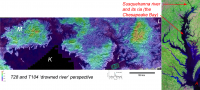
The excitement over new magic islands in Kraken and sunglint from the large sea almost (but not quite) distracts one from an equally exciting bathymetry (white arrow) obtained during T104 and discussed in Photojournal PIA19046 http://photojournal.jpl.nasa.gov/catalog/PIA19046. Here are measurements of the depth of Kraken at the outlet of a drowned river valley or ria imaged previously during T 28 http://pirlwww.lpl.arizona.edu/~perry/RADAR/#T28. That one can analyze such earthly appearing but alien analogs from afar is mindboggling.
One might also wonder if the composition of the upper reaches of the drowned river bring a different mix of liquid hydrocarbons to the estuary akin to the fresh water-salt water mixing in many of earths drowned valleys. The figure below puts the drowned river valley in perspective with a broader view of SAR T28 and topographic data from PIA10353 (also in Photojournal) http://photojournal.jpl.nasa.gov/catalog/?IDNumber=pia10353 and compares it with the Susquehanna river ria known as the Chesapeake Bay on the east coast of the USA. In the figure K = Kraken, M = Mayda Insula and L = Ligeia. The Chesapeake Bay is roughly 300 km long from the Susquehanna River inlet (top red arrow) to the Atlantic Ocean outlet (A) photo credit NASA/Landsat https://www.google.com/url?sa=i&rct=j&a...416362873092336.
|
|
|
|
|
|
|
Nov 23 2014, 04:45 AM
Post
#79
|
|
|
Member Group: Members Posts: 611 Joined: 23-February 07 From: Occasionally in Columbia, MD Member No.: 1764 |
QUOTE (titanicrivers @ Nov 17 2014, 09:16 PM) One might also wonder if the composition of the upper reaches of the drowned river bring a different mix of liquid hydrocarbons to the estuary akin to the fresh water-salt water mixing in many of earths drowned valleys. Very astute speculation. Entirely possible, both on the small scale you describe, and perhaps on the larger scale - it could be that the entire Ligeia-Kraken system has a methane/ethane variation akin to the salinity gradient between the sea of Azov/Black Sea/Mediterranean or Baltic/North Sea, where ethane (+propane etc.) are essentially analogs of salt (i.e. an involatile solute tracer) and the enhanced precipitation at high latitudes leads to 'fresher' composition there... See http://www.lpl.arizona.edu/~rlorenz/flushing.pdf It may be that radar data (radiometry, and/or attenuation measurements in bottom-sounding altimetry) or bistatic radio reflection experiments can constrain the compositions somewhat. Possibly also near-IR spectroscopy from VIMS. |
|
|
|
|
Nov 23 2014, 11:31 AM
Post
#80
|
|
|
Senior Member Group: Members Posts: 3516 Joined: 4-November 05 From: North Wales Member No.: 542 |
Should we also expect a vertical 'salinity' gradient within the lakes, as we find in the Black Sea? Searching around I found liquid densities of 0.421 and 0.546 for methane and ethane respectively - quite a large difference. I note that in the Bosphorus there is a deep salty current flowing in and fresh surface water flowing out at one and the same time. Maybe something similar happens at the Throat of Kraken.
|
|
|
|
|
Nov 23 2014, 03:35 PM
Post
#81
|
|
|
Member Group: Members Posts: 204 Joined: 14-April 06 From: Seattle, WA Member No.: 745 |
QUOTE (titanicrivers @ Nov 17 2014, 06:16 PM) That one can analyze such earthly appearing but alien analogs from afar is mindboggling. Yes! And that I can 'listen' in on this conversation is equally so. Thank you so much for that and for the links. Ron |
|
|
|
|
Nov 23 2014, 04:59 PM
Post
#82
|
|
|
Senior Member Group: Moderator Posts: 2785 Joined: 10-November 06 From: Pasadena, CA Member No.: 1345 |
Once again, Titan has the potential to be even more complicated than the simple Earth story. One of the fun possible "twists" in the story on Titan compared to Earth is that fluids percolating through the subsurface of Titan can exchange with clathrates. That would depend on the exact structure of the clathrates (structure I or structure II) and the kinetic rate of exchange (flow rate, contact time, initial mix, etc.) with the clathrates in the subsurface. So the hydrocarbon and nitrogen fluid mix going into the subsurface can be different than the fluid mix coming out. Think of it as having an ethane or methane sponge that sucks up one or two of the hydrocarbons.
Check out: Mousis et al., 2014: http://arxiv.org/pdf/1405.6588.pdf Bottom line (!) is that you could have a propane-rich subsurface spring popping up under the surface of one of the lakes. But that would all depend on the kinetic rates, structures of the subsurface and the starting mix of the fluids. So it has the potential to be a very, very complex system. As always, more laboratory work is needed. And as Ralph likes to point out during his presentations, most of the calculations are done assuming everything is at equilibrium. As we know from our terrestrial experiences, very few of us are ever at equilibrium. Last time I checked, my relative humidity was a loooooong ways away from 100% saturation (the equilibrium state). Using equilibrium calculatoins for Titan is a good start to see the idealized case, but the reality on (and under) the ground will be even more complicated. -------------------- Some higher resolution images available at my photostream: http://www.flickr.com/photos/31678681@N07/
|
|
|
|
|
Nov 24 2014, 03:09 AM
Post
#83
|
|
|
Member Group: Members Posts: 611 Joined: 23-February 07 From: Occasionally in Columbia, MD Member No.: 1764 |
QUOTE (ngunn @ Nov 23 2014, 06:31 AM) Should we also expect a vertical 'salinity' gradient within the lakes, as we find in the Black Sea? Searching around I found liquid densities of 0.421 and 0.546 for methane and ethane respectively - quite a large difference. I note that in the Bosphorus there is a deep salty current flowing in and fresh surface water flowing out at one and the same time. Maybe something similar happens at the Throat of Kraken. Indeed. Same thing happens at Gibraltar (as I noted in my Throat of Kraken paper). Stratification is something I'm looking into with Tetsuya Tokano. Stevenson and Potter back in the mid-80s suggested a seasonal CH4 layer might form on top of a denser C2H6 layer (but they thought it would happen in winter - it rather seems now instead it might be a summer rainfall thing). Transient layers of fresh water do form on Earth's seas (arctic freshwater pool, Amazon plume, etc.) - the question is how quickly things may get mixed up. Tokano in 2009 looked at thermal stratification. But with methane/ethane/nitrogen/etc the composition effects and temperature effects can trump each other - there's a phenomenon ('rollover') where this has happened in LNG storage tanks - am writing something up about this in a titan context. |
|
|
|
|
Feb 13 2015, 01:13 AM
Post
#84
|
||
|
Member Group: Members Posts: 701 Joined: 1-April 08 From: Minnesota ! Member No.: 4081 |
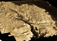
Antoine Lucas’ de-noising technique featured in today’s Photojournal article http://photojournal.jpl.nasa.gov/catalog/PIA19051 and http://saturn.jpl.nasa.gov/news/cassinifea...eature20150211/ provides an interesting perspective and relatively noise free view of the drowned river valley of T28. The small stream tributaries one might have anticipated are nicely shown in the de-noised view (included below).
|
|
|
|
|
|
|
Feb 15 2015, 01:07 AM
Post
#85
|
||
|
Member Group: Members Posts: 701 Joined: 1-April 08 From: Minnesota ! Member No.: 4081 |
The drowned river in the de-noised, despeckled perspective http://photojournal.jpl.nasa.gov/catalog/PIA19051 with topography from PIA10353 http://photojournal.jpl.nasa.gov/catalog/?IDNumber=pia10353 overlain is shown below. Titans rivers are said to show little in the way of erosive action http://newsoffice.mit.edu/2012/river-networks-on-titan-0720 but I wonder if the area circled might be a substantial valley cut into the icy uplands. A rough estimate based on the elevation scale shows a 400m difference between the river bed and adjacent upland over a relatively short distance of 5-10 km.
|
|
|
|
|
|
|
Feb 15 2015, 12:35 PM
Post
#86
|
|
|
Member Group: Members Posts: 401 Joined: 5-January 07 From: Manchester England Member No.: 1563 |
Looking at the side by side comparison images in the press release, here, the despeckled images look much less like I was expecting - like they have giant seaweed draped ove the Titanian surface
 Parts of it just look... too smooth! Parts of it just look... too smooth!
-------------------- |
|
|
|
|
Feb 15 2015, 03:16 PM
Post
#87
|
|
|
Junior Member Group: Members Posts: 78 Joined: 16-October 12 From: Pennsylvania Member No.: 6711 |
Couldn't they do that with any object mapped by radar? Like, lets say, Venus?
|
|
|
|
|
Aug 29 2015, 09:42 PM
Post
#88
|
|
|
Member Group: Members Posts: 701 Joined: 1-April 08 From: Minnesota ! Member No.: 4081 |
A nice article on Titan’s lakes and seas appears in the October 2015 issue of Astronomy magazine. http://www.astronomy.com/magazine/2015/08/...=NjIyNzQwMDg5S0. PIA 18432 http://photojournal.jpl.nasa.gov/catalog/PIA18432 is featured on the cover and on p. 25 of this publication. The author, Alexander G. Hayes, provides an authoritative summary of what is known about Titan’s seas including the composition, radio wave absorptivity and depth of the major bodies of liquid on Titan http://www.hou.usra.edu/meetings/lpsc2014/pdf/2341.pdf. SAR images of the “magic islands” in Ligeia Mare, a nice comparison of rounded surface ‘boulders’ on Titan and Earth and discussion about Titan’s lake distribution change with time are highlighted.
|
|
|
|
|
Aug 29 2015, 11:18 PM
Post
#89
|
|
 Member Group: Members Posts: 684 Joined: 24-July 15 Member No.: 7619 |
QUOTE (rlorenz @ Nov 23 2014, 04:45 AM) QUOTE (titanicrivers @ Nov 17 2014, 09:16 PM) One might also wonder if the composition of the upper reaches of the drowned river bring a different mix of liquid hydrocarbons to the estuary akin to the fresh water-salt water mixing in many of earth’s drowned valleys. Very astute speculation. Entirely possible, both on the small scale you describe, and perhaps on the larger scale - it could be that the entire Ligeia-Kraken system has a methane/ethane variation akin to the salinity gradient between the sea of Azov/Black Sea/Mediterranean or Baltic/North Sea, where ethane (+propane etc.) are essentially analogs of salt (i.e. an involatile solute tracer) and the enhanced precipitation at high latitudes leads to 'fresher' composition there... Neat ideas- there appears to be an impact crater in the Titan image, which reminds me that there is a large crater under Chesapeak bay. That crater was found because of odd groundwater flow in that area, freshwater, regular sea water and brine. One theory is that the heat from the chesapeak impact vaporized the water from deep aquifer seawater to create a concentrated brine. Very interesting to think about what chemistry and fractionation you might get from an impact into hydrocarbon seas. |
|
|
|
|
Jan 15 2016, 02:08 AM
Post
#90
|
|
 Member Group: Members Posts: 723 Joined: 13-June 04 Member No.: 82 |
Compositional Similarities and Distinctions between Titan's Evaporitic Terrains
QUOTE We document the similarities in composition between the equatorial basins Tui Regio, Hotei Regio, and other 5-μm-bright materials, notably the north polar evaporites, by investigating the presence and extent of an absorption feature at 4.92 μm. In most observations, Woytchugga Lacuna, Ontario Lacus, MacKay Lacus, deposits near Fensal, some of the lakes and dry lake beds south of Ligeia, and the southern shores of Kraken Mare share the absorption feature at 4.92 \um observed in the spectra of Tui and Hotei. Besides Woytchugga and at Fensal, these 5-μm-bright deposits are geomorphologically-substantiated evaporites. Thus, the similarity in composition strengthens the hypothesis that Tui and Hotei once contained liquid. Other evaporite deposits, however, do not show the 4.92 \um absorption, notably Muggel Lacus and the shores of Ligeia Mare at the north pole. This difference in composition suggests that there are more than one kind of soluble material in Titan's lakes that can create evaporite and/or that the surface properties at the VIMS wavelength scale are not uniform between the different deposits (crystal size, abundance, etc). Our results indicate that the surface structure, composition, and formation history of Titan's evaporites may be at least as dynamic and complex as their Earth counterparts. |
|
|
|
|
Jul 22 2016, 07:47 AM
Post
#91
|
|
|
Senior Member Group: Members Posts: 3516 Joined: 4-November 05 From: North Wales Member No.: 542 |
Some of the best ISS overviews of the northern lakes are appearing now:
http://saturn-archive.jpl.nasa.gov/multime...5/N00263235.jpg EDIT: This is from the Ciclops 'looking ahead: "Late on July 26, ISS will acquire a series of cloud tracking observations covering Titan’s north polar region. On July 27 Titan will be observed during a calibration observation of the polarizer filters on ISS." I will be looking to see if the lakes look markedly different through the different polarizers. |
|
|
|
|
Jul 22 2016, 11:32 PM
Post
#92
|
||
|
Lord Of The Uranian Rings Group: Members Posts: 798 Joined: 18-July 05 From: Plymouth, UK Member No.: 437 |
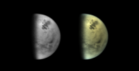
This is a 'color' version using the CB3, MT1 and MT3 filters:
-------------------- |
|
|
|
|
|
|
Jul 23 2016, 04:01 PM
Post
#93
|
|
|
Senior Member Group: Moderator Posts: 3233 Joined: 11-February 04 From: Tucson, AZ Member No.: 23 |
Going for the MEX VMC look?
 Looks very nice. -------------------- &@^^!% Jim! I'm a geologist, not a physicist!
The Gish Bar Times - A Blog all about Jupiter's Moon Io |
|
|
|
|
Jul 23 2016, 07:00 PM
Post
#94
|
|
|
Lord Of The Uranian Rings Group: Members Posts: 798 Joined: 18-July 05 From: Plymouth, UK Member No.: 437 |
Thanks Jason! Yeah, I've been looking for a way to give the CB3 frames some color for a while now, and seemed to have hit upon a recipe that works:
 Titan 2015-OCTOBER-02 by Ian Regan, on Flickr 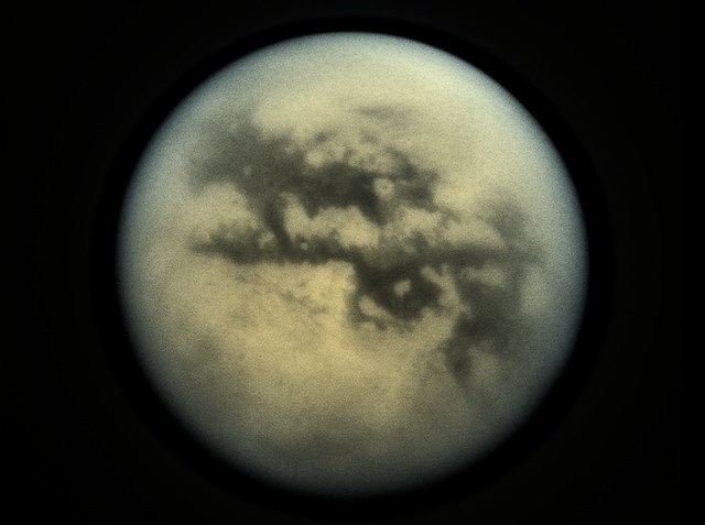 Titan 2009-JUNE-25 by Ian Regan, on Flickr -------------------- |
|
|
|
|
Aug 4 2016, 11:43 PM
Post
#95
|
||
|
Lord Of The Uranian Rings Group: Members Posts: 798 Joined: 18-July 05 From: Plymouth, UK Member No.: 437 |
The latest view from August 3rd:
-------------------- |
|
|
|
|
|
|
Aug 6 2016, 11:57 AM
Post
#96
|
||
|
Lord Of The Uranian Rings Group: Members Posts: 798 Joined: 18-July 05 From: Plymouth, UK Member No.: 437 |
And from the following day, August 4th:
-------------------- |
|
|
|
|
|
|
Aug 11 2016, 03:52 AM
Post
#97
|
|
|
Member Group: Members Posts: 362 Joined: 13-April 06 From: Malta Member No.: 741 |
The study by Poggiali et al published describes radar studies which seem to show fluid filled valleys draining into Ligeia Mare. The continuous presence of fluid within these canyons in the absence of precipitation would thus seem to indicate a subsurface source of liquid methane?
|
|
|
|
|
Sep 12 2016, 03:40 AM
Post
#98
|
|
|
Lord Of The Uranian Rings Group: Members Posts: 798 Joined: 18-July 05 From: Plymouth, UK Member No.: 437 |
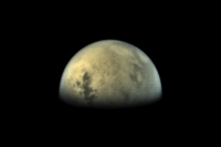
-------------------- |
|
|
|
|
Sep 13 2016, 02:46 PM
Post
#99
|
|
 Member Group: Members Posts: 146 Joined: 22-November 14 From: Bormida (SV) - Italy Member No.: 7348 |
Here's my version of Titan on 10 September
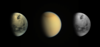
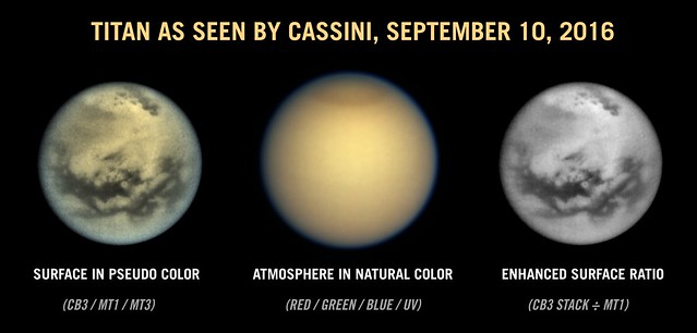
red, gr, bl and uv filter at right and 3 cb3 stack at left In this view, with Sinlap crater in the middle, we can see: Kraken Mare, Lingeia Mare, Jingpo Lacus, Bolsena Lacus, Ledoga Lacus and Punga Mare. 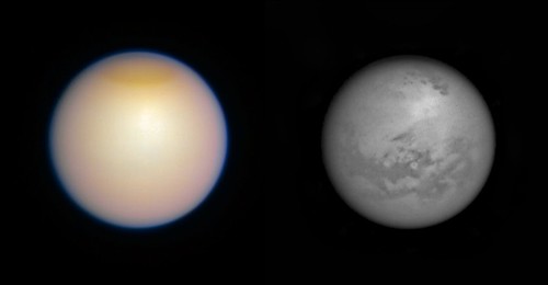
-------------------- |
|
|
|
|
Sep 23 2016, 09:42 AM
Post
#100
|
||
|
Lord Of The Uranian Rings Group: Members Posts: 798 Joined: 18-July 05 From: Plymouth, UK Member No.: 437 |
The latest observation of Titan (from the 21st):
-------------------- |
|
|
|
|
|
|

|
Lo-Fi Version | Time is now: 5th June 2024 - 08:27 AM |
|
RULES AND GUIDELINES Please read the Forum Rules and Guidelines before posting. IMAGE COPYRIGHT |
OPINIONS AND MODERATION Opinions expressed on UnmannedSpaceflight.com are those of the individual posters and do not necessarily reflect the opinions of UnmannedSpaceflight.com or The Planetary Society. The all-volunteer UnmannedSpaceflight.com moderation team is wholly independent of The Planetary Society. The Planetary Society has no influence over decisions made by the UnmannedSpaceflight.com moderators. |
SUPPORT THE FORUM Unmannedspaceflight.com is funded by the Planetary Society. Please consider supporting our work and many other projects by donating to the Society or becoming a member. |
|