Geomorphology of Gale Crater, Rock on! |

  |
Geomorphology of Gale Crater, Rock on! |
 Sep 26 2012, 10:22 PM Sep 26 2012, 10:22 PM
Post
#1
|
|
|
Senior Member  Group: Members Posts: 3516 Joined: 4-November 05 From: North Wales Member No.: 542 |
I'd like a discussion thread about the geology detatched from the time limits of current MSL threads. We had a 'Geomorphology of Cape York' thread that attracted a lot of interesting posts. How about 'Geomorphology of Gale Crater'? I have one or two ideas but many more questions, and I'd like to post them in a longer-running thread away from the day to day imaging discussion. Any other takers?
For starters, does anybody have a contour map of this place like the one at Meridiani with 5m intervals? ADMIN: You have your wishes fulfilled on UMSF (sometimes) 
|
 |
 
|
|
Sep 27 2012, 12:42 AM
Post
#2
|
|
|
Junior Member Group: Members Posts: 85 Joined: 5-September 12 Member No.: 6635 |
I'm a little confused about the layers on Mt. Sharp. Could one of you geology types set me straight?
a) the thinking is that the mound is a remnant of the vast sediment that once filled gale crater correct?  If so, wouldn't most if not all of the sedimentary layers be flat since no tectonic activity has occured? If so, wouldn't most if not all of the sedimentary layers be flat since no tectonic activity has occured?Perhaps it is a trick of perspective but all of the layers I can see in the buttes and mesas below the discontinuity are uniformily tilted up toward Mt. Sharp. So I'm wondering if the layers have nothing to do with the original deposition but are an artifact of more recent aeolian erosion. |
|
|
|
|
Sep 27 2012, 01:25 AM
Post
#3
|
|
|
Junior Member Group: Members Posts: 59 Joined: 12-March 10 From: Austin, TX Member No.: 5262 |
QUOTE (ngunn @ Sep 26 2012, 05:22 PM)  How about 'Geomorphology of Gale Crater'? I like that idea. I, too, have some questions perhaps better posted there. |
|
|
|
|
Sep 27 2012, 01:25 AM
Post
#4
|
|
|
Solar System Cartographer Group: Members Posts: 10183 Joined: 5-April 05 From: Canada Member No.: 227 |
Sediment settling out of a fluid onto a flat surface might make horizontal layers, but other situations can make tilted layers from the start. In particular, if the surface is already tilted and you start depositing layers of wind-born material (sand, volcanic ash etc.) on it, each layer could follow the slope of the ground underneath it for quite a while until upper layers became more level.
Another possiblity - layers form fairly horizontally over uneven topography. Then over time they gradually compact under their own weight, but more so in areas of deeper sediment fill ("differential compaction"), resulting in deformed layers. So we can't just assume layers would be horizontal. Phil -------------------- ... because the Solar System ain't gonna map itself.
Also to be found posting similar content on https://mastodon.social/@PhilStooke Maps for download (free PD: https://upload.wikimedia.org/wikipedia/comm...Cartography.pdf NOTE: everything created by me which I post on UMSF is considered to be in the public domain (NOT CC, public domain) |
|
|
|
|
Sep 27 2012, 03:16 AM
Post
#5
|
|
 Senior Member Group: Members Posts: 3419 Joined: 9-February 04 From: Minneapolis, MN, USA Member No.: 15 |
One rim of Gale Crater is quite a bit higher above mean than the other, right? Even though it appears to be a regular ringwall kind of structure, not breached nor significantly out of circular. It could be that much of Mt. Sharp was deposited in horizontal layers and the overall ground mass below the entire crater could have tilted before the deflation that exposed the central mound and revealed the horizons we now see as the floor. The entire subsurface table tilting would account for the different heights of the rim between north and south.
As to what could have caused the entire subsurface below Gale to tilt -- well, the Tharsis bulge was responsible for enormous deformations of the crust. Also, if this area of Mars ever went through extensive glaciations, the entire subsurface could have been pushed down by the weight of the glaciers during the deposition of Mt. Sharp's layers, and has since recovered its original elevation and orientation via isostatic rebound. Finally, if the material that supposedly infilled the entire crater (and has since been deflated) was emplaced by a rapidly moving force, such as the rush of waters or repeated pyroclastic flows from the same vent area, well, that material could have piled up on the far wall and filled back from there. If the force emplacing the materials was consistently from the same vector, you would get layers that are tilted in a sort of compromise between the gravity vector and the emplacement vector. In other words, there are a lot of ways on Mars that you can get tilted and discontinuous rock beds, you don't have to assume tectonic processes. -the other Doug -------------------- The trouble ain't that there is too many fools, but that the lightning ain't distributed right. -Mark Twain
|
|
|
|
|
Sep 27 2012, 03:20 AM
Post
#6
|
|
|
Senior Member Group: Members Posts: 2089 Joined: 13-February 10 From: Ontario Member No.: 5221 |
Could we figure out a ballpark estimate for the size of the original impactor that formed Gale, or is it too degraded?
There's online simulators but they're for Earth impacts only... |
|
|
|
|
Sep 27 2012, 04:34 AM
Post
#7
|
|
|
Senior Member Group: Members Posts: 1045 Joined: 17-February 09 Member No.: 4605 |
Great idea ngunn.
To appreciate the variations in layering we need to take into account the sheer size of this crater (some 18,000 square kilometres) and the necessary presence of a central uplift which could possibly be a factor in Mt Sharp resisting erosion. Seemingly lots of water early on with aeolian deposition/erosion subsequently. Being on the slope at the edge of the dichotomy there would have been a gravitational gradient towards the north. Couple this with cycles of depositition, variable lithification and differential erosion over billions of years and as impied by dvandorn and Phil, flat layers without variation rather than uneven layering would be the eyebrow raiser. |
|
|
|
|
Sep 27 2012, 07:39 AM
Post
#8
|
|
|
Senior Member Group: Members Posts: 3516 Joined: 4-November 05 From: North Wales Member No.: 542 |
(Thanks admin
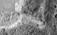
 ) )I have been wondering about the 'high thermal inertia' region that is now in front of us. It looks like it has been somehow scoured clean of loose material. Noting also that it is located ahead of the margin of a presumed alluvial fan, I have been wondering if that 'fan' could actually be the remains of a long-outrun avalanche that formed very rapidly, sending a powerful shock wave ahead of it that blasted the soil off this area. |
|
|
|
|
Sep 27 2012, 10:11 AM
Post
#9
|
|
 Senior Member Group: Members Posts: 1465 Joined: 9-February 04 From: Columbus OH USA Member No.: 13 |
The operative sentence from the Anderson/Bell paper:
QUOTE Despite interest in Gale Crater as a potential landing site, the origin of the mound remains enigmatic.
-------------------- |
|
|
|
|
Sep 27 2012, 06:03 PM
Post
#10
|
|
|
Senior Member Group: Members Posts: 3516 Joined: 4-November 05 From: North Wales Member No.: 542 |
Also in that paper (pp107-8) is discussion of the low-thermal-inertia/high-thermal-inertia fan formations and the nature of the boundary between them. We are approaching the margin of the HTIF Glenelg. We'll soon have some new data to match against the proposed interpretation.
|
|
|
|
|
Sep 27 2012, 08:25 PM
Post
#11
|
|
 Member Group: Members Posts: 154 Joined: 17-March 05 Member No.: 206 |
Great idea for this thread.
Since there is no obvious outlet along the rim wall for water / glaciers etc to have eroded the crater bed to, I lean in favor of the theory that the floor of the crater actually dropped, instead of eroding away (with some later minor depositing which smoothed the floor out). Since Mt Sharp sat atop the old central peak of the original crater, it did not sink like the rest of the crater floor. My two and one-half cents 
|
|
|
|
|
Sep 27 2012, 08:30 PM
Post
#12
|
|
|
Founder Group: Chairman Posts: 14433 Joined: 8-February 04 Member No.: 1 |
QUOTE (Chmee @ Sep 27 2012, 01:25 PM) Since there is no obvious outlet along the rim wall for water / glaciers etc to have eroded the crater bed to, Why must it have been water? The theories I have seen suggest wind. |
|
|
|
|
Sep 27 2012, 08:45 PM
Post
#13
|
|
|
Senior Member Group: Members Posts: 3516 Joined: 4-November 05 From: North Wales Member No.: 542 |
Add to that the possibility of quite a lot of ice in the original crater fill and you have sublimation as another removal mechanism.
|
|
|
|
|
Sep 27 2012, 09:16 PM
Post
#14
|
|
|
Junior Member Group: Members Posts: 85 Joined: 5-September 12 Member No.: 6635 |
Also note that Curiosity is sitting on or very near the lowest spot on the planet (outside of Hellas).
How did it get that way ? There are far larger craters along the global dichotomy. I suspect that the uniqueness of Mt. Sharp and the fact that it is immediately adjacent to this global low spot ... is not a coincidence |
|
|
|
|
Sep 28 2012, 05:10 AM
Post
#15
|
|
|
Senior Member Group: Members Posts: 1045 Joined: 17-February 09 Member No.: 4605 |
QUOTE (Eyesonmars @ Sep 27 2012, 10:16 PM) I suspect that the uniqueness of Mt. Sharp and the fact that it is immediately adjacent to this global low spot ... is not a coincidence Not unique. Emily did a rather nice presentation on this. http://www.planetary.org/blogs/emily-lakda.../2011/3144.html |
|
|
|
|
Sep 28 2012, 05:48 AM
Post
#16
|
|
|
Junior Member Group: Members Posts: 94 Joined: 11-August 12 Member No.: 6536 |
Anybody like the idea of a mud volcano for Mt Sharp? Looking at the way the upper layers are tilted, it looks like something came out of the top and flowed down the flanks. In fact I think I recall reading something about a hydrothermal spring as an origin theory for the mound.
Somebody asked about the size of the impactor that made the crater. Gale is about the same size as Chicxulub, which is linked to the extinction of the dinosaurs, and is said to have been made by a 6 mile diameter asteroid. |
|
|
|
|
Sep 28 2012, 08:41 AM
Post
#17
|
|
|
Member Group: Members Posts: 282 Joined: 18-June 04 Member No.: 84 |
What kind of theories and ideas are floating around to possibly explain the composition and origin of the Glenelg/high thermal emission region? It seems to be right at the base of the Alluvial fan. Perhaps it's where that water pooled into a small lake.
|
|
|
|
|
Sep 28 2012, 10:46 AM
Post
#18
|
|
|
Senior Member Group: Members Posts: 3516 Joined: 4-November 05 From: North Wales Member No.: 542 |
See the discussion I referred to in post 10 for starters, plus the MSL team's conclusion that the fan extends to the landing site, i.e. beyond the margin of HTIF.
|
|
|
|
|
Sep 28 2012, 01:18 PM
Post
#19
|
|
|
Junior Member Group: Members Posts: 85 Joined: 5-September 12 Member No.: 6635 |
QUOTE (serpens @ Sep 28 2012, 05:10 AM) Not unique. Emily did a rather nice presentation on this. http://www.planetary.org/blogs/emily-lakda.../2011/3144.html I based my comment on many hours of using the VERY cool app "Mars Globe" by M. Howard and brought to my attention by E. Lakdawalla. It is a must have app on the iPad. (everyone I show it to is fascinated by it) While I do see quite a few craters with what might be central sedimentary mounds. Most of them could also be remnant central peaks and are much smaller compared to their craters than Mt. Sharp. |
|
|
|
|
Sep 28 2012, 08:01 PM
Post
#20
|
|
|
Member Group: Members Posts: 122 Joined: 19-June 07 Member No.: 2455 |
I'm having a hard time reconciling from the newly released pictures where exactly Glenelg is in them. When I look at the overhead route updates it appears the rover is moving East (I'm assuming North is to the top of the image) along the base of Mt Sharp with Glenelg further to the East. Logic says that if we're facing Glenelg and targeting it in the images, Mt Sharp should be to the left and yet all the images being returned are looking to the left of Mt Sharp or at its left-most flanks. Could someone show an overhead route map that includes where Mt. Sharp is in context of our journeys and what direction these latest images are pointing.
|
|
|
|
|
Sep 28 2012, 08:05 PM
Post
#21
|
|
|
Senior Member Group: Members Posts: 3516 Joined: 4-November 05 From: North Wales Member No.: 542 |
QUOTE (Art Martin @ Sep 28 2012, 09:01 PM) Could someone show an overhead route map that includes where Mt. Sharp is in context of our journeys and what direction these latest images are pointing. Here: http://www.unmannedspaceflight.com/index.p...st&p=192020 |
|
|
|
|
Sep 28 2012, 08:08 PM
Post
#22
|
|
|
Solar System Cartographer Group: Members Posts: 10183 Joined: 5-April 05 From: Canada Member No.: 227 |
Art, Mt Sharp runs all around the south horizon from due east to south to southwest. It's really big! The pics ngunn linked to show that well.
Phil -------------------- ... because the Solar System ain't gonna map itself.
Also to be found posting similar content on https://mastodon.social/@PhilStooke Maps for download (free PD: https://upload.wikimedia.org/wikipedia/comm...Cartography.pdf NOTE: everything created by me which I post on UMSF is considered to be in the public domain (NOT CC, public domain) |
|
|
|
|
Sep 28 2012, 08:08 PM
Post
#23
|
||
 Administrator Group: Admin Posts: 5172 Joined: 4-August 05 From: Pasadena, CA, USA, Earth Member No.: 454 |
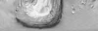
I made this two days ago -- it's an un-polar projection (if that makes sense) of the CTX image of Gale, centered on Curiosity's landing site. The bottom edge of the image is Curiosity's location (the "pole," if you will); the top edge is about 18 kilometers away. Everything along the same horizontal line in this image is at the same distance from the rover. Due south is in the center of the image; due north is at the edges.
The sand dunes skirting the mountain occupy about 160 degrees of Curiosity's point of view, which means you'll see the mountain on your right if you're looking east, on your left if you're looking west, and in front of you if you're looking south; the only time the mountain wouldn't be in your field of view is if you're looking north.
Attached thumbnail(s)
-------------------- My website - My Patreon - @elakdawalla on Twitter - Please support unmannedspaceflight.com by donating here.
|
|
|
|
|
|
|
Sep 28 2012, 08:41 PM
Post
#24
|
|
|
Member Group: Members Posts: 122 Joined: 19-June 07 Member No.: 2455 |
Thanks, so much clearer now. I just had no idea of the scale of things before. The link from ngunn put things into perspective and spun me around the right direction. Amazing image Emily, thanks. The lines showing our travels wouldn't even show up on your picture other than maybe a pixel. Ok back to lurking in amazement.
|
|
|
|
|
Sep 28 2012, 09:40 PM
Post
#25
|
|
|
Senior Member Group: Members Posts: 3516 Joined: 4-November 05 From: North Wales Member No.: 542 |
QUOTE (elakdawalla @ Sep 28 2012, 09:08 PM) un-polar projection (if that makes sense) I really like these. James Canvin used them effectively to identify horizon features seen by Opportunity and he calls them 'inverse polars'. I think that's a good term for them. Any chance of extending yours to include the crater rim? |
|
|
|
|
Sep 28 2012, 10:17 PM
Post
#26
|
||
|
Administrator Group: Admin Posts: 5172 Joined: 4-August 05 From: Pasadena, CA, USA, Earth Member No.: 454 |
That is precisely what I was using it for. Don't know when I'll get to finish this, so here's a preliminary version, featuring a touch of Phil-O-Vision.
It'd be easy to make a version extending to the rim. How many pixels wide would be useful? Is 3600 enough? 7200?
Attached thumbnail(s)
-------------------- My website - My Patreon - @elakdawalla on Twitter - Please support unmannedspaceflight.com by donating here.
|
|
|
|
|
|
| Guest_fthurber_* |
Sep 28 2012, 10:57 PM
Post
#27
|
|
Guests |
QUOTE (elakdawalla @ Sep 28 2012, 06:17 PM) That is precisely what I was using it for. Don't know when I'll get to finish this, so here's a preliminary version, featuring a touch of Phil-O-Vision. It'd be easy to make a version extending to the rim. How many pixels wide would be useful? Is 3600 enough? 7200? WOW! Nice job. BTW, the dragon's teeth at the bottom of the sulfate layer look like nunateks, but, of course, they are not. I assume that the vertical scale in the bottom picture is exaggerated, right? |
|
|
|
|
Sep 29 2012, 12:15 AM
Post
#28
|
||
|
Administrator Group: Admin Posts: 5172 Joined: 4-August 05 From: Pasadena, CA, USA, Earth Member No.: 454 |
Here you go. Attached version is 3600 pixels wide (10 pixels per degree) and somewhat compressed. Here is a less-compressed 7200 wide version. The original data for this one was at about 55 meters per pixel, so it's of lower quality in the near field, but it's fine at the distance of the crater rim.
Attached thumbnail(s)
-------------------- My website - My Patreon - @elakdawalla on Twitter - Please support unmannedspaceflight.com by donating here.
|
|
|
|
|
|
|
Sep 29 2012, 01:34 AM
Post
#29
|
|
|
Member Group: Members Posts: 866 Joined: 15-March 05 From: Santa Cruz, CA Member No.: 196 |
QUOTE (Eyesonmars @ Sep 27 2012, 02:16 PM) Also note that Curiosity is sitting on or very near the lowest spot on the planet (outside of Hellas). ... i'd always thought Hellas was an ancient ancient impact resulting in a sort of unsuspecting ocean basin much later, though i don't know if theres much evidence of that. Makes me wonder on how much Gale's similarly lower elevation affected atmospheric pressure back during that thicker warmer atmosphere? im curious what models might suggest as far as atmospheric pressure at Gale vs the mean elevation during that time and if it makes sense to expect that to have much impact on making a Gale lake more habitable. Or the processional inclination at the time might have kept the Gale interior iced over with Vostok-style lake beneath but probably heated by plenty of geothermal activity. how much glaciation and erosion of the crater walls would be expected under that scenario and if extensive, could evidence of that type have been erased by now. ok, too many stray hairs, i wont even get started on Mt Sharp, its all too enigmatic.. |
|
|
|
|
Sep 29 2012, 02:36 AM
Post
#30
|
|
|
Senior Member Group: Members Posts: 3419 Joined: 9-February 04 From: Minneapolis, MN, USA Member No.: 15 |
QUOTE (atomoid @ Sep 28 2012, 08:34 PM) i'd always thought Hellas was an ancient ancient impact resulting in a sort of unsuspecting ocean basin much later, though i don't know if theres much evidence of that. I used to think along those lines, too. But the orbiters (especially Odyssey) have seen almost no indication of hydrogen in Hellas -- i.e., no indication of subsurface ice or even strongly hydrated materials. Instead of harboring water in the past, these results tend to indicate that Hellas has never seen much water at all. I think that's likely why it has never been considered as an attractive landing site, even though it is such a low spot that the atmospheric pressure there is higher at the surface than just about anywhere else on Mars. Hellas would be a wonderful landing site if you're looking to examine Martian mantle materials, because it is certainly deep enough to have exhumed mantle rocks. Geologically speaking, it's very attractive. But since the main interest in Mars is (and, I think, always has been) the investigation of water, habitability and life, the geologic questions that drove the exploration and analysis of the Moon are taking a back seat to the water- and life-seekers when it comes to Mars. -the other Doug -------------------- The trouble ain't that there is too many fools, but that the lightning ain't distributed right. -Mark Twain
|
|
|
|
| Guest_fthurber_* |
Oct 1 2012, 01:47 AM
Post
#31
|
|
Guests |
QUOTE (dvandorn @ Sep 28 2012, 10:36 PM) Instead of harboring water in the past, these results tend to indicate that Hellas has never seen much water at all. I think that's likely why it has never been considered as an attractive landing site, even though it is such a low spot that the atmospheric pressure there is higher at the surface than just about anywhere else on Mars. Hi Doug Was Hellas was thought to have some glacial formations? Maybe the ice is covered so deep by rock debris and dust that it cannot be picked up by the spectrometer. However my source is Wikipedia so that may be wrong. http://en.wikipedia.org/wiki/Hellas_Planit...sible_glaciers/ Supposedly MROs radar sounder saw it. |
|
|
|
|
Oct 1 2012, 05:59 PM
Post
#32
|
|
|
Junior Member Group: Members Posts: 38 Joined: 14-August 12 Member No.: 6558 |
A question about redox and sedimentary paleoenvironments on Mars:
One of the things I've been thinking about the last few days is that my instincts w/r/t paleoenvironments is all wrong when it comes to Mars. Take "hottah" - when I saw that, I immediately thought "oh, its cool as hell, but I see why they didn't stop there - fluvial conglomerates are notoriously poor environments to preserve organics". But that's wrong, or rather, potentially wrong, on Mars, isn't it? It's true on earth in post-proterozoic rocks b/c the atmosphere is oxic and sediment deposited in well-mixed water will lead to oxidized organics, most likely through biologic activity. But who-the-hell-knows what the Mars atmosphere was like when those conglomerates were deposited? Wouldn't it be more likely that the conglomerates were deposited in a reducing environment, like those auriferous precambrian conglomerates in south africa? Is that necessarily a bad environment for preservation of organics? Which leads me to my next point, color. When you look at some of the finely-bedded outcrops that the pictures are showing, they're clearly darker and, more importantly, greyer than the overlying rocks (e.g. compared to the hottah, which seems to be a light tan). Earth-instincts; that's a shale or shale-like rock, deposited in an anoxic environment. But why would that be so on Mars? I guess EVERY lacustrine-type depositional environment on Mars could be anoxic, but, that's not consistent with where Mars eventually evolves to and what MER observed. Redox is all a big mystery, right? We don't know the chemsistry, and one thing that seems likely is that the biologicially mediated redox chemistry that you see in sediments in Earth is unlikely to apply there. And do our usual Earth-honed instincts about color & redox state of the paleoenvironment hold true? And, to sum it all up, to the extent we don't know much about any of the above, how the heck do we know where to look for preserved organics? |
|
|
|
|
Oct 1 2012, 07:03 PM
Post
#33
|
|
|
Administrator Group: Admin Posts: 5172 Joined: 4-August 05 From: Pasadena, CA, USA, Earth Member No.: 454 |
Re: Hottah, that's a good question, and there were a lot of talks at landing site selection meetings about what kinds of rocks were good for preserving organics. Grotz's emphasis through the last three rounds of meetings was preservation, preservation, preservation. High-energy environments like mountain streams are not good places. Fine sediment settling in deltaic environments are good, which was why Eberswalde was the other favored landing site. So you're probably right, Hottah was cool but not the paleo-environment they were looking for. Glenelg has better potential.
Mars doesn't have an oxygen atmosphere but it does have strong oxidizers acting at the surface, so some of the chemistry is analagous. That goes out of my depth though. Check the landing site selection meeting website, there are probably some presentations addressing Martian aqueous chemistry. -------------------- My website - My Patreon - @elakdawalla on Twitter - Please support unmannedspaceflight.com by donating here.
|
|
|
|
|
Oct 1 2012, 08:50 PM
Post
#34
|
|
|
Junior Member Group: Members Posts: 85 Joined: 5-September 12 Member No.: 6635 |
The area Curiosity has been traversing has quite a few small, mostly ghostly, circular features ( looking at the route map). Assuming they are impact related - are they primary or secondary impacts ? Do they date from the time of creation of the deposit or have they been created after/during erosion exposed the surface. I'm surprised at how dense they area. Our eventual target area, the phyllosilicate area, also has these craters in abundance. They seem to have a maximum size cutoff.
What do they tell us ? |
|
|
|
|
Oct 1 2012, 09:11 PM
Post
#35
|
|
|
Junior Member Group: Members Posts: 38 Joined: 14-August 12 Member No.: 6558 |
QUOTE (elakdawalla @ Oct 1 2012, 03:03 PM) Re: Hottah, that's a good question, and there were a lot of talks at landing site selection meetings about what kinds of rocks were good for preserving organics. Grotz's emphasis through the last three rounds of meetings was preservation, preservation, preservation. High-energy environments like mountain streams are not good places. Fine sediment settling in deltaic environments are good, which was why Eberswalde was the other favored landing site. So you're probably right, Hottah was cool but not the paleo-environment they were looking for. Glenelg has better potential. Mars doesn't have an oxygen atmosphere but it does have strong oxidizers acting at the surface, so some of the chemistry is analagous. That goes out of my depth though. Check the landing site selection meeting website, there are probably some presentations addressing Martian aqueous chemistry. Mars has strong oxidizers acting at the surface now. IIRC, however, the redox chemistry is thought to have been totally different back when clays may-or-may not have been being deposited. I would presume in a higher-Ph surface environment, most sedimentary settings would be reducing - like Precambrian earth. |
|
|
|
|
Oct 1 2012, 09:31 PM
Post
#36
|
|
|
Senior Member Group: Members Posts: 3516 Joined: 4-November 05 From: North Wales Member No.: 542 |
Eyesonmars: Interesting question. Here's an off-the shelf response based on the conventional story about impact crater counts and age of surfaces. No big craters means a spell of significant deposition or erosion since heavy bombardment ceased. Many small craters means little net deposition or erosion for a very long time after the reworking of the surface that erased the big ones.
This being Mars you'd have to add that these little craters must have formed into a relatively dry surface since the little impactors couldn't have penetrated a significant thickness of water or ice. Like you, I think the peculiar density of craters here, just above the Glenelg boundary, is significant. It could signify the exposure of an ancient surface neither mantled (as at Bradbury Landing) nor scoured away (Glenelg high thermal inertia unit). I note its similarity to the third type of terrain to the SE of Glenelg. |
|
|
|
|
Oct 2 2012, 07:41 PM
Post
#37
|
|
|
Junior Member Group: Members Posts: 85 Joined: 5-September 12 Member No.: 6635 |
QUOTE (ngunn @ Oct 1 2012, 09:31 PM) Like you, I think the peculiar density of craters here, just above the Glenelg boundary, is significant. It could signify the exposure of an ancient surface neither mantled (as at Bradbury Landing) nor scoured away (Glenelg high thermal inertia unit). I note its similarity to the third type of terrain to the SE of Glenelg. Pure conjecture here: If this dense crater network is an ancient feature that has been exhumed recently can we infer that the atmosphere must have been quite thin at this time? As I understand it there is a relationship between minimum crater size and mass of an atmosphere. IF so, and ( another IF) the cratered surface dates to roughly the time of the next surface below - our alluvial fan/stream bed - does this fact influence our interpretation of what we assume (almost certainly) is the water carved/deposited features in front of us ?? |
|
|
|
|
Oct 4 2012, 08:39 PM
Post
#38
|
|
|
Senior Member Group: Members Posts: 3516 Joined: 4-November 05 From: North Wales Member No.: 542 |
I've just come across this detailed thermal inertia map. Let's see if the link works:
http://www.nasa.gov/images/content/692124m...-43_946-710.jpg EDIT Well it sort of worked, but it leaves out the caption and the link to the bigger version. I'll have another go . . http://www.nasa.gov/mission_pages/msl/mult.../pia16159.html#
|
|
|
|
|
Oct 4 2012, 09:34 PM
Post
#39
|
|
|
Founder Group: Chairman Posts: 14433 Joined: 8-February 04 Member No.: 1 |
Yes - the full size is here : http://www.nasa.gov/images/content/692127m...9-full_full.jpg
I find the NASA HQ websites very hard to navigate so I tend to use the photojournal where you'll find it also http://photojournal.jpl.nasa.gov/catalog/PIA16159 (PS Base map from Fred Calef, annotation by me ) |
|
|
|
|
Oct 4 2012, 09:56 PM
Post
#40
|
|
|
Senior Member Group: Members Posts: 3516 Joined: 4-November 05 From: North Wales Member No.: 542 |
Brilliant! Thanks Doug. While you're on the line, can you point us to a contour map of this place (my quest in post 1)? We're in an enclosed basin and since ancient liquid water is in play I'd like to get a sense of which direction is down and where the bottom is.
|
|
|
|
|
Oct 4 2012, 10:10 PM
Post
#41
|
|
|
Founder Group: Chairman Posts: 14433 Joined: 8-February 04 Member No.: 1 |
Contour - no - but there is this - http://photojournal.jpl.nasa.gov/jpeg/PIA16158.jpg
You could have found it by going to the first page under 'Mars' on the photojournal. |
|
|
|
|
Oct 4 2012, 10:30 PM
Post
#42
|
|
|
Senior Member Group: Members Posts: 3516 Joined: 4-November 05 From: North Wales Member No.: 542 |
That's good, and there's also this:
http://blogs.esa.int/mex/2012/08/03/gale-crater-in-3d/ However they're not really at the level of detail required to help us 'on the ground'. |
|
|
|
|
Oct 4 2012, 11:12 PM
Post
#43
|
|
|
Junior Member Group: Members Posts: 85 Joined: 5-September 12 Member No.: 6635 |
True. But even at 100 meters/pixel you can just make out the channel where it enters Gale crater and the upper portions of the alluvial fan.
(we are looking southwest so the channel enters from the far right) |
|
|
|
|
Oct 4 2012, 11:17 PM
Post
#44
|
|
|
Administrator Group: Admin Posts: 5172 Joined: 4-August 05 From: Pasadena, CA, USA, Earth Member No.: 454 |
-------------------- My website - My Patreon - @elakdawalla on Twitter - Please support unmannedspaceflight.com by donating here.
|
|
|
|
|
Oct 5 2012, 08:48 AM
Post
#45
|
|
|
Senior Member Group: Members Posts: 3516 Joined: 4-November 05 From: North Wales Member No.: 542 |
Just what I was looking for, thanks Emily.
|
|
|
|
|
Oct 6 2012, 09:30 AM
Post
#46
|
|
|
Senior Member Group: Members Posts: 3516 Joined: 4-November 05 From: North Wales Member No.: 542 |
I am particularly intrigued by the enclosed depression on the right of Peter's contoured elevation map:
http://petergrindrod.net/wp-content/upload...g-site-topo.png The depression coincides exactly with the outer margin of the high thermal inertia fan (HTIF). I'm also curious about where the substantial quantity of flowing water that formed the fan was actually flowing to. I'm toying with the idea that it spread out and froze in place, forming over time a substantial ice deposit. I don't know the proper name for such a thing so for now I'm calling it an 'ice snout'. Maybe all of the HTIF is a marker for the former extent of the ice snout. Sublimation of volatiles is widely invoked to explain hollows. Here we appear to have a hollow and a ready supply of volatile material at some time in the past. There are what look like polygonal markings on the bottom of the depression. Where have we seen that before? I can't wait to get down there. |
|
|
|
|
Oct 6 2012, 07:26 PM
Post
#47
|
|
|
Junior Member Group: Members Posts: 85 Joined: 5-September 12 Member No.: 6635 |
QUOTE (ngunn @ Oct 6 2012, 10:30 AM) I am particularly intrigued by the enclosed depression on the right of Peter's contoured elevation map: http://petergrindrod.net/wp-content/upload...g-site-topo.png Sublimation of volatiles is widely invoked to explain hollows. Hmm - The peculiarity of the craterlet density in the unit covering the area SE of Glenelg has been mentioned earlier in this thread. Notice the complete saturation and fairly uniform size of these little hollows in the eastern part of this unit. Could this unit be a remnant of a sediment saturated outflow that was deposited more or less all at once ?? Assuming the slurry is near the triple point pressure of H20, small variations in conditions within the slurry could result in explosive boiling one place while a few meters away the slurry is still liquid. At the same time it is rapidly freezing on its surface so that the little craterlets that are left behind as the vapor bubble breaks the surface are flash frozen in place. IF the slurry is thick enough the craterlets might still be discernible as the remaining H20 slowly sublimates away and the remaining dry deposit settles. (this is somewhat consistent with your "ice snout" idea) |
|
|
|
|
Oct 6 2012, 08:53 PM
Post
#48
|
|
|
Senior Member Group: Members Posts: 3516 Joined: 4-November 05 From: North Wales Member No.: 542 |
It's fun to look at those craterlets and imagine the kind of one-off event you describe, although I'm having difficulty with the idea of individual bubbles of the required size. There's a long timespan and a wide range for climate parameters (including, crucially, the total mass of the atmosphere) available as possible conditions for the processes that formed this landcape so it's open season for imaginative suggestions, I think.
EDIT: I've looked again and the crater sizes go right down there: too small for impacts under any kind of atmosphere. Interesting. |
|
|
|
|
Oct 6 2012, 09:08 PM
Post
#49
|
|
|
Junior Member Group: Members Posts: 85 Joined: 5-September 12 Member No.: 6635 |
I agree. It is great fun to try to imagine processes that are beyond our earth biased experiences.
Over on the "Temperature and Pressure" topic I've been making trouble with the goal of perhaps gaining some insight into the subject of this thread. It is hard to imagine how water might behave around the triple point on a large scale in a low g environment since it is beyond our earthly experience. But small changes can have major phase consequences. In addition, in the low Martian gravity I would imagine the bubbles would grow larger than on earth .... true? |
|
|
|
|
Oct 6 2012, 09:30 PM
Post
#50
|
|
|
Junior Member Group: Members Posts: 85 Joined: 5-September 12 Member No.: 6635 |
Also - as you queried - Where is the water flowing to
I've always been struck by the apparent contradiction between the ubiquitous, planet-wide evidence of flowing liquids on Mars but the almost complete lack of any strong evidence of any standing liquids on Mars at any time in Martian history. Mars is trying to tell us something. |
|
|
|
|
Oct 6 2012, 10:12 PM
Post
#51
|
|
|
Senior Member Group: Members Posts: 3516 Joined: 4-November 05 From: North Wales Member No.: 542 |
QUOTE (Eyesonmars @ Oct 6 2012, 10:30 PM) the almost complete lack of any strong evidence of any standing liquids on Mars at any time in Martian history I don't think that's quite true. I'm fairly persuaded by the the northern ocean shorelines. But you're right. It is the nature of water on Mars to do its deed and disappear, into space no doubt but also under ground (perhaps not very far). |
|
|
|
|
Oct 7 2012, 03:22 AM
Post
#52
|
|
|
Senior Member Group: Members Posts: 1045 Joined: 17-February 09 Member No.: 4605 |
QUOTE (Eyesonmars @ Oct 6 2012, 09:08 PM) It is hard to imagine how water might behave around the triple point on a large scale in a low g environment since it is beyond our earthly experience. The evidence of long lasting fluvial activity around and in gale would seem to indicate that the pressure and temperature 3 to 4 billion years ago was significantly different to today. From the apparent inverted channels it seems that most recently Gale has gone through a significant deflationary cycle. The topography during the fluvial period may have been quite different to today and some of the effects such as the hollows could be attributable to differential erosion. The low/high thermal inertia units look like part of the same fan. An alluvial fan that transitioned to an alluvial fan delta when it encountered standing water? Stranger things have happened. |
|
|
|
|
Oct 7 2012, 07:40 AM
Post
#53
|
|
|
Senior Member Group: Members Posts: 3516 Joined: 4-November 05 From: North Wales Member No.: 542 |
QUOTE (serpens @ Oct 7 2012, 04:22 AM) The low/high thermal inertia units look like part of the same fan. An alluvial fan that transitioned to an alluvial fan delta when it encountered standing water? Stranger things have happened. Another interesting idea. Does the LTIF/HTIF boundary follow a topgraphic contour, and if so, how big an area does that contour enclose? We will need a more extensive map to answer such questions.Here's a variation on my 'ice snout' suggestion. In warmer conditions the fan could have terminated in a 'salt snout' rather than an icy one. Flood the whole area at a later epoch and the salt redissolves - another way to form a hollow perhaps. (Would that count as differential erosion?) |
|
|
|
|
Oct 7 2012, 08:59 AM
Post
#54
|
|
|
Member Group: Members Posts: 293 Joined: 22-September 08 From: Spain Member No.: 4350 |
Mmh, is the assumed order of events: 1) the last sulfate layers of Mt Sharp were deposited; 2) Mt Sharp was eroded; 3) The fan was deposited on the new floor of Gale Crater?
In that case the fan would be from an age long after conditions were suitable for the standing acidic water that created Mt Sharp layers, and after a dry period in which all the erosion happened. Maybe the atmosphere was gone already, and they were just seasonal flash streams from molten ice that then sublimated away. |
|
|
|
|
Oct 7 2012, 02:00 PM
Post
#55
|
|
|
Senior Member Group: Members Posts: 1045 Joined: 17-February 09 Member No.: 4605 |
The filled then excavated crater hypothesis seems a logical explanation for the reasonably thick clay layer exposed at the base of Mount Sharp (neutral pH), beneath the sulphates. The clay layer could be a lacustrine deposition and if so then the fan would possibly have formed at that time, been covered and then excavated. Curiosity will probably be able to clarify with ground truth.
|
|
|
|
|
Oct 7 2012, 09:30 PM
Post
#56
|
|
|
Junior Member Group: Members Posts: 59 Joined: 12-March 10 From: Austin, TX Member No.: 5262 |
QUOTE (Eyesonmars @ Oct 6 2012, 04:30 PM) Also - as you queried - Where is the water flowing to That's the question I wanted to ask on this forum also. I'm interested in identifying the lowest point in Gale between here and where we expect to head up to Sharp for two reasons: 1. It may be where some water went as some time in the geological history of Gale and 2. It could/should be the point where we'd expect to find the oldest layers in the stratigraphy of Gale/Sharp. I didn't identify any mention of such a location in the Anderson paper (not that that means it isn't there). It would seem orienting to me to know where that is and what's already know about what's there (for orbital images, spectroscopic studies, etc.) |
|
|
|
|
Oct 7 2012, 09:51 PM
Post
#57
|
|
|
Senior Member Group: Members Posts: 3516 Joined: 4-November 05 From: North Wales Member No.: 542 |
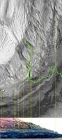
There are contours derived from CTX by Peter Grindrod here:
http://petergrindrod.net/wp-content/upload...CTX-context.png That shows we are right on the edge of an enclosed depression. I don't know whether it's the deepest in the whole crater, but if water flowed over the alluvial fan today I think it would have nowhere to go except into the hollow we are overlooking now. |
|
|
|
|
Oct 8 2012, 04:16 PM
Post
#58
|
||
|
Junior Member Group: Members Posts: 59 Joined: 18-July 07 From: London, UK Member No.: 2873 |
After a few requests, I've made some base maps of Gale and the Bradbury Landing site at a few different zoom levels.
They're all linked over here, with a bit of an accompanying explanation. A scaled down example of what's there:
Hopefully they might be of some use in discussions like those above. Pete |
|
|
|
|
|
|
Oct 8 2012, 07:10 PM
Post
#59
|
|
|
Senior Member Group: Members Posts: 3516 Joined: 4-November 05 From: North Wales Member No.: 542 |
Extremely helpful and much, much appreciated.
|
|
|
|
|
Oct 9 2012, 01:23 AM
Post
#60
|
|
|
Junior Member Group: Members Posts: 59 Joined: 12-March 10 From: Austin, TX Member No.: 5262 |
Thanks Pete, very helpful indeed. One of the things I keep wondering about is the much bigger inflow channel (and alluvial fan?) coming in from the southwest crater rim. These maps show there is a very big "sink" at the end of the "fan" (roughly due west of the peak of Sharp), much bigger than the one at Glenelg. It would seem that deposits from that channel would not come into play at Glenelg by my reading, but I'm not sure of that. If the SW channel is the older one, I guess it's possible that it's deposits did reach Glenelg.
|
|
|
|
|
Oct 16 2012, 02:30 AM
Post
#61
|
||
|
Senior Member Group: Members Posts: 1465 Joined: 9-February 04 From: Columbus OH USA Member No.: 13 |
A paper from the MSL team to be delivered at the Geological Society of America conference in Charlotte next month talks about an area on Mt Sharp containing "boxwork" structures:
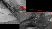
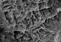
QUOTE Boxwork structures are mapped in a distinctive sedimentary layer exposed on Mount Sharp in shallow depressions about 700 m above Curiositys landing ellipse in Gale Crater. This layer, exposed over about 1 km2, is characterized by penetrative fracture networks expressed as ridges and separated by shallow depressions (2-10 m diameter) that are filled with dark windblown sand. Ridges are light-toned, averaging 4-5 m in width and sometimes marked by a thin dark strip (0-1.5 m across) in the center of the ridge. These are interpreted as large-scale boxwork structures, formed when saturated groundwater flowed through the fractured host rock and crystals precipitated within fractures and pores in the host rock, making the fractures more resistant to weathering than unaltered host rock. After weathering, the fracture fills stand as topographically higher rims around eroded host rock. Curious to know where that is on the HiRISE imagery. Might it be this area in the large (what appears to be) outflow channel?
Other ideas? -------------------- |
|
|
|
|
|
|
Oct 16 2012, 05:34 AM
Post
#62
|
|
 Junior Member Group: Members Posts: 43 Joined: 7-August 12 From: The Netherlands Member No.: 6493 |
Hi Joe,
I think you are slightly too high up the mount. I believe they are talking about the polygonal structures as shown on page 30 of: http://marsoweb.nas.nasa.gov/landingsites/...d_final_opt.pdf Greetings, Ludo. |
|
|
|
|
Oct 16 2012, 06:16 AM
Post
#63
|
|
 Senior Member Group: Members Posts: 2228 Joined: 1-December 04 From: Marble Falls, Texas, USA Member No.: 116 |
QUOTE (jmknapp @ Oct 15 2012, 08:30 PM) A paper from the MSL team to be delivered at the Geological Society of America conference in Charlotte next month talks about an area on Mt Sharp containing "boxwork" structures: ... Those large scale boxwork stuctures may be the most spectacular geomorphic features Curiosity images on this mission. I can only hope that Curiosity will send us some amazing pics as she carefully traverses the area.-------------------- ...Tom
I'm not a Space Fan, I'm a Space Exploration Enthusiast. |
|
|
|
|
Oct 16 2012, 11:24 AM
Post
#64
|
||
|
Senior Member Group: Members Posts: 1465 Joined: 9-February 04 From: Columbus OH USA Member No.: 13 |
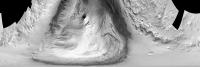
Ludo, thanks for that--looks like a good inference, based on the caption. Here's a full-res HiRISE detail from the area:
I'd imagine that rover driver skills would be taxed to get into that maze of twisty passages. CosmicRocker--beyond amazing pictures, the other instruments could probably feast on the crystalline minerals formed in the cracks. -------------------- |
|
|
|
|
|
|
Nov 5 2012, 05:24 AM
Post
#65
|
|
 Member Group: Members Posts: 215 Joined: 23-October 12 From: Russia Member No.: 6725 |
Greetings from Russia
I want to share my observation. I looked at pictures and noticed that many of the stones are similar to volcanic.  It seems even that lava river.  So close to be a volcano? This is clearly not Elysium Mons In the north-west is the mountain, which can be a volcano?  It turns out it can be a source of the alluvial fan and inverted (lava?) channels? 
-------------------- My blog on Patreon
|
|
|
|
|
Nov 5 2012, 06:06 PM
Post
#66
|
|
|
Junior Member Group: Members Posts: 30 Joined: 6-September 12 From: Denver Member No.: 6641 |
Hi, my first post.
The problem with a volcanic interpretation of these landforms is the conglomerates already discovered. Conglomerates only form in alluvial environments, where water has flowed and rounded the cobbles. I agree that some of the rocks look like volcanic in nature, but the closeup images taking with the MARDI they show no mineral grains. This means the grains are smaller, at least on the surface, than the resolving power of MARDI, which is pretty small. The only volcanic rocks that I have seen with no visible grains is volcanic glass. Since volcanic glass is not stable, at least on Earth, it should have devitrified by now, and show some crystallization of the rock. Of course reality is probably a mix of both alluvial processes and volcanic process were involved with the formations we see today. Which makes this area probably the more exciting spot explored on Mars so far, sorry opportunity. Mod: Excessive quoting removed. Read rule 3.5 please. |
|
|
|
|
Nov 28 2012, 04:35 PM
Post
#67
|
|
|
Senior Member Group: Members Posts: 3419 Joined: 9-February 04 From: Minneapolis, MN, USA Member No.: 15 |
QUOTE (Phil Stooke @ Nov 28 2012, 03:37 PM) You can see it an awful lot better in the Navcam anaglyph on page 2 of this thread. It's difficult to do geomorphology from Hazcam anaglyphs because the field of view is so limited. That hummock is just part of the edge of a much wider resistant layer that forms a major terrace all around the depression. Well... the one end of the depression that is obvious in the most recent pans that have been assembled, here, looks rather circular. Anything that describes a partial or complete circle on Mars, with its higher impact rate than we are accustomed to on Earth, could be the remnants of an impact crater. The flow lines etched into the rock working into the depression could just be the result of eons of aeolian modification. However -- and this is a big however -- the overall morphology of the region is indicative of alluvial activity, i.e., modification from flowing water. So, even though the edge of this depression is circular and may still represent the remnants of an impact crater, with the clues to alluvial action we can see in the aerial images, it looks to me that the initial modification of the terrain is more likely from water flowing and then ponding in the topographic low point of the depression. Multiple episodes of flash flooding, or continuous drainage from the central mound, could have resulted in the patterns we see. In any event, the original forces that carved the topography here at Glenelg has since been modified by many, many eons of aeolian erosion since the last of the flowing water was seen here. -the other Doug
Reason for edit: Link to the main thread
-------------------- The trouble ain't that there is too many fools, but that the lightning ain't distributed right. -Mark Twain
|
|
|
|
|
Nov 28 2012, 04:48 PM
Post
#68
|
|
|
Administrator Group: Admin Posts: 5172 Joined: 4-August 05 From: Pasadena, CA, USA, Earth Member No.: 454 |
One feature very common to Gale crater, both its floor and on the central mound, is "inverted topography," where there is something that looks like a stream valley (with dendritic tributary or distributary features), except that it stands higher than the surrounding terrain, rather than lower. That is generally interpreted to mean that there once was a valley, whose fill was, for whatever reason, more resistant to erosion than the material into which it carved. The fact that it stands high now tells you that the whole surrounding landscape has been deflated, eroded away, since the last time there was significant fluvial activity here.
-------------------- My website - My Patreon - @elakdawalla on Twitter - Please support unmannedspaceflight.com by donating here.
|
|
|
|
|
Nov 28 2012, 05:12 PM
Post
#69
|
|
|
Newbie Group: Members Posts: 7 Joined: 18-September 12 Member No.: 6655 |
QUOTE (elakdawalla @ Nov 28 2012, 11:48 AM) the whole surrounding landscape has been deflated, eroded away, since the last time there was significant fluvial activity here. One thing that I don't quite understand is where did all the eroded surface go? Does it have places where it accumulates preferentially? How many meters of surface can we expect to be removed in 2-3 billion years? At some point the erosion stops because the landscape is already covered with sand, so there must be some upper and lower limits to this phenomenon. |
|
|
|
|
Nov 28 2012, 05:41 PM
Post
#70
|
|
|
Solar System Cartographer Group: Members Posts: 10183 Joined: 5-April 05 From: Canada Member No.: 227 |
At some point if the debris breaks down into sufficiently small particles it can be removed from the vicinity, even lifted out of Gale crater completely. So it might not remain in this area to choke off further erosion.
We had a small move, slightly backwards and to the left, so a rock slab that was immediately adjacent to the left front wheel is now slightly further away and right of center where the arm can work on it. Following common practice in the past I expect it backed up a bit, turned, moved forwards again to the desired location, and turned to face the rock. It's hardly enough of a move to warrant updating the route map just yet. Phil -------------------- ... because the Solar System ain't gonna map itself.
Also to be found posting similar content on https://mastodon.social/@PhilStooke Maps for download (free PD: https://upload.wikimedia.org/wikipedia/comm...Cartography.pdf NOTE: everything created by me which I post on UMSF is considered to be in the public domain (NOT CC, public domain) |
|
|
|
|
Nov 28 2012, 06:25 PM
Post
#71
|
|
|
Senior Member Group: Members Posts: 2517 Joined: 13-September 05 Member No.: 497 |
QUOTE (ddan @ Nov 28 2012, 10:12 AM) One thing that I don't quite understand is where did all the eroded surface go? Good question. I don't think anyone knows yet. From Malin and Edgett, "Sedimentary rocks of early Mars", Science, 2000, http://www.sciencemag.org/content/290/5498...&siteid=sci (italics mine) QUOTE Not only is evidence of the depositional processes not apparent, neither, in most cases, are the processes that exposed and eroded the layered and massive units (with the obvious exceptions of faulting in the Valles Marineris and the presence of yardangs that imply wind erosion). For example, Henry Crater contains 10,000 km3 of material in an isolated mound within the crater. This material is layered and stands nearly as high as the crater rim. This observation implies that some process or processes have removed 15,000 km3 of material from Henry Crater. Notwithstanding recognition of morphologies that suggest an apparent sequence illustrating removal of material from impact craters, the actual processes are unknown. The implication is that most of the exposure and erosion of the layered units must have occurred some time far in the martian past, when transport out of the craters (again, with no obvious transport pathways) could have occurred via processes not acting on the planet today. -------------------- Disclaimer: This post is based on public information only. Any opinions are my own.
|
|
|
|
|
Nov 28 2012, 08:08 PM
Post
#72
|
|
 Member Group: Members Posts: 267 Joined: 5-February 06 Member No.: 675 |
The uniformitarian in me gets nervous when I read an appeal to "processes not acting on the planet today".
But as a historian of science, what do I know. Steve
|
|
|
|
|
Nov 28 2012, 08:27 PM
Post
#73
|
|
|
Senior Member Group: Members Posts: 3516 Joined: 4-November 05 From: North Wales Member No.: 542 |
It's a great phrase isn't it? Get's you out of any problem - except that it doesn't. With its 'impossible' central mound Gale crater is the perfect place to seek real answers to that big Martian mystery.
Meanwhile at Glenelg we have a smaller mystery but one whose resolution should also prove enlightening. Why did the removal process, whatever it was, selectively target the outer margin of an alluvial fan? |
|
|
|
|
Nov 29 2012, 02:52 AM
Post
#74
|
||
|
Member Group: Members Posts: 215 Joined: 23-October 12 From: Russia Member No.: 6725 |
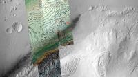
My thought involves this element. It looks as a wave or stream consequence.
Attached thumbnail(s)
-------------------- My blog on Patreon
|
|
|
|
|
|
| Guest_Actionman_* |
Nov 29 2012, 01:10 PM
Post
#75
|
|
Guests |
QUOTE (ngunn @ Nov 28 2012, 03:27 PM) With its 'impossible' central mound Gale crater is the perfact place to seek real answers to that big Martian mystery. I would think that would be a good reason not to to go here... which in all honesty means i should have a theory/hypothesis but I don't see the word "glacial" mused much. Here it goes: Rock slipping inward to the center from a thick ice glacier. Some of these rock seem to show frost heave to me. |
|
|
|
|
Nov 29 2012, 03:02 PM
Post
#76
|
|
|
Founder Group: Chairman Posts: 14433 Joined: 8-February 04 Member No.: 1 |
Are you suggesting that Mt Sharp is just a pile of terminal moraine?
Where is the evidence for the glaciers themselves - the glacial valleys? |
|
|
|
| Guest_Actionman_* |
Nov 29 2012, 05:41 PM
Post
#77
|
|
Guests |
yes, maybe
glacial cone/funnel Some evidence would be that much of the surface rocks the larger ones we see has little or no impact signatures like they would have landed on snow or ice. Flat sediment slabs we're seeing right now don't have many rocks on them, sled off. |
|
|
|
|
Nov 29 2012, 05:50 PM
Post
#78
|
|
|
Solar System Cartographer Group: Members Posts: 10183 Joined: 5-April 05 From: Canada Member No.: 227 |
There is plenty of evidence for glaciers elsewhere on Mars, but none here. Let's try to keep the focus of this forum on the images, that's where it really shines.
Phil -------------------- ... because the Solar System ain't gonna map itself.
Also to be found posting similar content on https://mastodon.social/@PhilStooke Maps for download (free PD: https://upload.wikimedia.org/wikipedia/comm...Cartography.pdf NOTE: everything created by me which I post on UMSF is considered to be in the public domain (NOT CC, public domain) |
|
|
|
|
Nov 29 2012, 06:45 PM
Post
#79
|
|
|
Member Group: Members Posts: 154 Joined: 17-March 05 Member No.: 206 |
QUOTE (mcaplinger @ Nov 28 2012, 01:25 PM) Good question. I don't think anyone knows yet. From Malin and Edgett, "Sedimentary rocks of early Mars", Science, 2000, http://www.sciencemag.org/content/290/5498...&siteid=sci (italics mine) QUOTE (ddan @ Nov 28 2012, 10:12 AM) * One thing that I don't quite understand is where did all the eroded surface go? Well, I can think of 2 methods: 1. Ice / Glaciers - After Gale formed, water entered the crater, creating a lake, which then froze over with the central mount sticking out. Sediment accumulated over the ice in layers (and the central peek), essentially filling the crater 'to to the brim'. Later, perhaps as the Martian atmosphere lost most of it's density (or the polar tilt moved Gale from polar region to equatorial) the ice sublimed away, sinking the floor down, but maintaining the central peek. 2. Fractured/Soft Material - When Gale formed, the rock under the crater floor had less strength then the central peek. The crater filled up with sediment over time, again near the rim of the crater. However, over the eons, all that weight compressed the original material in the crater floor, in effect sinking or slumping the floor away from the rim and central peek. Just my 2 cents! |
|
|
|
|
Nov 29 2012, 09:13 PM
Post
#80
|
|
|
Senior Member Group: Members Posts: 1045 Joined: 17-February 09 Member No.: 4605 |
QUOTE (SteveM @ Nov 28 2012, 09:08 PM) The uniformitarian in me gets nervous when I read an appeal to "processes not acting on the planet today". That seems a bit harsh. There are pretty clear indications that early Mars was a very energetic environment, predominantly aeolian with at least episodic fluvial periods. Living as we do in a corrosive and energetic erosional environment I guess that most of us have difficulty really understanding just how benign present day Mars is, or the immense amount of time that has elapsed since that more energetic environment. The statement processes not acting on the planet today seems appropriate given the current lack of any significant mechanical or chemical erosion. There is pretty clear evidence of massive erosional/depositional cycles across ancient Mars. I think all agree that the Gale central mound is sedimentary (possibly with a remnant central uplift core) and most of this material would have come from somewhere else. The deposition appears to have taken an extended time since the changes as we go up the mound could potentially map the changing depositional environment. Heresy perhaps but the ESA definitions of the Martian eras actually seem to make more sense (intuitively at least) than the traditional nomenclature. http://www.esa.int/esaCP/SEM117OFGLE_index_0.html Despite the remnant fluvial valleys and inverted channels, the lack of transport pathways out of the crater indicates that fluvial influences would not seem to have been significant in the excavation process. Aeolian seems the culprit. I could imagine the crater partially filled by deposited materiel and I wonder if a vortexing effect around the rim could have actually moved material from rimward to the central area resulting in the moat around the mound. That would account for some of the eroded material. Where did the rest go? Mars wide, Arabia Terra and Meridiani alone account for hundreds of thousands of cubic kilometres of sedimentary material and there are probably a lot of sedimentary traps across the surface of Mars. I guess a lot ended up in the Northern plains. |
|
|
|
| Guest_Actionman_* |
Nov 30 2012, 12:20 AM
Post
#81
|
|
Guests |
It's a cinch we're not going to be finding bedrock, NASA came here looking for bedrock.. didn't they.
Bedrock should be at the bottom of a deep crater, shouldn't it. We would like to fine something solid some place. No bedrock on lake affect... if the area is below the frost line. |
|
|
|
|
Nov 30 2012, 12:36 AM
Post
#82
|
|
|
Founder Group: Chairman Posts: 14433 Joined: 8-February 04 Member No.: 1 |
QUOTE (Actionman @ Nov 29 2012, 04:20 PM) It's a cinch we're not going to be finding bedrock I don't think bedrock means what you think it means. The definition I've found "solid rock underlying loose deposits such as soil or alluvium." We have clearly already seen that at Gale crater - from the surface and from orbit. |
|
|
|
|
Nov 30 2012, 02:34 AM
Post
#83
|
|
 Senior Member Group: Members Posts: 2173 Joined: 28-December 04 From: Florida, USA Member No.: 132 |
QUOTE (Actionman @ Nov 29 2012, 07:20 PM) It's a cinch we're not going to be finding bedrock.... Gale crater is easily old enough for bedrock to have formed in it from once loose material that filled the crater. I think the mission is not to discover material from the surface that existed before the impact that formed Gale Crater. I think the mission is to learn the deposition history of the material that later filled the crater. That history is preserved in bedrock that formed long after the crater's creation and which now lies exposed in Mount Sharp and the area around it that Curiosity is currently exploring.
|
|
|
|
|
Nov 30 2012, 05:50 AM
Post
#84
|
|
|
Administrator Group: Admin Posts: 5172 Joined: 4-August 05 From: Pasadena, CA, USA, Earth Member No.: 454 |
QUOTE (Actionman @ Nov 29 2012, 04:20 PM) It's a cinch we're not going to be finding bedrock, I'm sorry to have to say it, but this sentence proves that you just don't know what you are talking about. I suggest you stop talking about geology, and just listen instead. You could really learn a lot here.I don't want to have to add a rule to section 2 that tells people not to post if they don't know what they are talking about. I feel that that should be obvious. -------------------- My website - My Patreon - @elakdawalla on Twitter - Please support unmannedspaceflight.com by donating here.
|
|
|
|
| Guest_Actionman_* |
Nov 30 2012, 12:13 PM
Post
#85
|
|
Guests |
I'm sorry elakda for making it sound too you like i'm talking about the Flintstones.
Bedrock on Mars as far as I know, now you correct me if I'm wrong: basalt. Not to be confused will the surface photos of conglomerate and limestone sediment slabs we see. We see chucks of basalt everywhere BUT what we don't see is the primal intact basalt global covering if there is one. Basalt like all the surface basalt littering the surface indicates there should be basalt in the floor a deep crater it should be revealed or even to have been blasted clean through. Bedrock is not compressed sediment. At lest not the type of bedrock I was talking about. NASA will be drilling for subsurface basalt NMHO. |
|
|
|
|
Nov 30 2012, 12:43 PM
Post
#86
|
|
|
Senior Member Group: Members Posts: 3516 Joined: 4-November 05 From: North Wales Member No.: 542 |
I think the term you want is 'basement rock' rather than 'bedrock'.
|
|
|
|
|
Nov 30 2012, 01:04 PM
Post
#87
|
|
|
Junior Member Group: Members Posts: 43 Joined: 7-August 12 From: The Netherlands Member No.: 6493 |
QUOTE We see chucks of basalt everywhere BUT what we don't see is the primal intact basalt global covering if there is one. If you refer to the Anderson and Bell paper on this subject: http://marsjournal.org/contents/2010/0004/...s_2010_0004.pdf, you'll find on page 122 a very nice graph showing exactly why we don't see the basalt yet. It's close, but MSL will need to drive towards the mount to find an exposed trough all the way down to the basalt unit. (In many places the dark dunes are actually covering the basalt floor, instead of on the sediment layers, see image 34a on page 109) Greetings, Ludo. |
|
|
|
| Guest_Actionman_* |
Nov 30 2012, 01:14 PM
Post
#88
|
|
Guests |
And thank you Ludo.
Make it so |
|
|
|
|
Nov 30 2012, 01:45 PM
Post
#89
|
|
|
Senior Member Group: Members Posts: 2173 Joined: 28-December 04 From: Florida, USA Member No.: 132 |
QUOTE (Actionman @ Nov 30 2012, 07:13 AM) ...Bedrock is not compressed sediment. At lest not the type of bedrock I was talking about. This mission is specifically designed to study the compressed sediments of Mount Sharp and the surrounding area. Not to look for subsurface basalt. The drill goes no deeper than a couple inches. The landing site was chosen because of the deep layered stack of compressed sediments that could be seen in Mount Sharp, not because of any sub-surface basalt.NASA will be drilling for subsurface basalt.... Edit: Here is a short description of why MSL went to Gale Crater. Notice, no mention of basalt. |
|
|
|
|
Nov 30 2012, 04:36 PM
Post
#90
|
|
|
Founder Group: Chairman Posts: 14433 Joined: 8-February 04 Member No.: 1 |
QUOTE (Actionman @ Nov 30 2012, 04:13 AM) NASA will be drilling for subsurface basalt They will not. I was right - you don't know what bedrock means. I'm going to repeat Emily's excellent words from earlier... this sentence proves that you just don't know what you are talking about. I suggest you stop talking about geology, and just listen instead. You could really learn a lot here. |
|
|
|
|
Nov 30 2012, 05:46 PM
Post
#91
|
|
 Senior Member Group: Members Posts: 1619 Joined: 12-February 06 From: Bergerac - FR Member No.: 678 |
Can I ask something ? Not very important, but for me it is. Modifiy the thread from "Geomorphology" to "Areomorphology". As "Geo" came frome "Gaia", the Earth in Greek mythology, so as "Areo" from "Arès", Mars in Greek mythology. But I will understand that's not necessary for the quality of this thread. After all, we use specific word to qualify a day on Mars like "sol"
.
-------------------- |
|
|
|
|
Nov 30 2012, 05:54 PM
Post
#92
|
|
 Senior Member Group: Admin Posts: 4763 Joined: 15-March 05 From: Glendale, AZ Member No.: 197 |
Not a good idea. The science of geology is what is being discussed here. If you drop one Greek root then you have to drop them all and it starts to sounds like nonsense.
-------------------- If Occam had heard my theory, things would be very different now.
|
|
|
|
| Guest_Actionman_* |
Nov 30 2012, 05:54 PM
Post
#93
|
|
Guests |
In this GIF from the above Mr. Anderson and James F. Bell paper they illustrate their view of the basal layer with the possibility of some of which maybe exposed. The examination of any of this is mandatory NMHO. More over I don't think it will be visible. Out of sight out of mind, apparently.
|
|
|
|
|
Nov 30 2012, 06:01 PM
Post
#94
|
|
|
Founder Group: Chairman Posts: 14433 Joined: 8-February 04 Member No.: 1 |
QUOTE (Ant103 @ Nov 30 2012, 09:46 AM) Can I ask something ? Not very important, but for me it is. Modifiy the thread from "Geomorphology" to "Areomorphology". What would you call Phobos geology. Deimos. Venus. Europa. Dione. Our own Moon. Titan. Nix. Hydra. Tempel 1. Itokawa. There are hundreds and thousands of worlds out there for us to explore, study and understand - and the science we will be practicing is geology / geomorphology / geochemistry etc etc. Having a different word for the same scientific discipline just because it's a different place is nonsensical. |
|
|
|
|
Nov 30 2012, 06:06 PM
Post
#95
|
|
|
Senior Member Group: Members Posts: 1619 Joined: 12-February 06 From: Bergerac - FR Member No.: 678 |
Okay, I understand totaly
I was just asking. It's funny because in french, when you land a probe onto a surface, we use the word "Atterrissage", with the root "Terre" aka Earth in english. And I'm against using word like "Amarsissage" when you land something on Mars. So then, yeah, I think I was a little too bit enthousiast . Nevermind . And thanks for the answers.
-------------------- |
|
|
|
|
Nov 30 2012, 06:16 PM
Post
#96
|
|
|
Founder Group: Chairman Posts: 14433 Joined: 8-February 04 Member No.: 1 |
QUOTE (Actionman @ Nov 30 2012, 09:54 AM) they illustrate their view of the basal layer with the possibility of some of which maybe exposed. The examination of any of this is mandatory NMHO. More over I don't think it will be visible. Out of sight out of mind, apparently. You know that Basal and Basalt are not the same thing, right? Not visible? They've already seen it (and attempted to characterise it) from orbit! From Page 105-106 of their paper ( for those unfamiliar - it's available here - http://www.marsjournal.org/contents/2010/0004/ ) "Light-toned basal unit The light-toned basal unit is distinguished from the crater floor units by a sharp drop of ~10 m (Figure 34a). The light-toned basal unit has a CTX albedo of up to 0.20, and is primarily composed of fractured rock that in some locations has a subtle texture suggestive of layering (Figure 39b). It has a moderate thermal inertia ranging from roughly 500-540 J m-2 K-1 s-1/2. Mesas of mound- skirting unit are common on top of the light-toned basal unit (Figure 34b), and much of the basal unit is covered by dark-toned mafic dunes. The light-toned basal unit slopes upward in a series of poorly-defined fractured, light-toned layers to form the northwestern side of the light-toned ridge unit (Figure 36a). Dark-toned basal unit The dark-toned basal unit (Figure 39) has a higher thermal inertia (~780 J m-2 K-1 s-1/2) than the light-toned basal unit. It has an albedo of 0.15-0.16 and occurs to the southwest of the landing ellipse and the light-toned basal unit. The transition between the light and dark-toned basal units (Figure 40) is sharp and the dark-toned basal unit appears to be topographically lower than the light-toned basal unit. This suggests that it is either stratigraphically lower or that the dark-toned unit is younger and fills a depression that had been eroded into the light-toned basal unit." Plus - the paper goes on explicitly define a location to visit to help in characterizing it is an important stop on any MSL traverse. |
|
|
|
| Guest_Actionman_* |
Nov 30 2012, 06:38 PM
Post
#97
|
|
Guests |
Basal and basalt are important distinctions both of which are said to scattered on the surface.
Any intact strata should be checked for type. That's all I'm saying. And no, basal strata in large thick strata placements are not visible from space here at Gale Crater. |
|
|
|
|
Nov 30 2012, 06:44 PM
Post
#98
|
|
|
Founder Group: Chairman Posts: 14433 Joined: 8-February 04 Member No.: 1 |
You can not scatter 'basal' on the surface. Basal is a descriptor derived from location. The basal unit is the bottom unit. It's not a type of material - it's a placement.
The basal unit IS visible from space. How do you think they mapped it and characterized it from orbit. Read the paper. Heck - just read the description I cited above. |
|
|
|
|
Nov 30 2012, 07:09 PM
Post
#99
|
|
|
Senior Member Group: Members Posts: 3516 Joined: 4-November 05 From: North Wales Member No.: 542 |
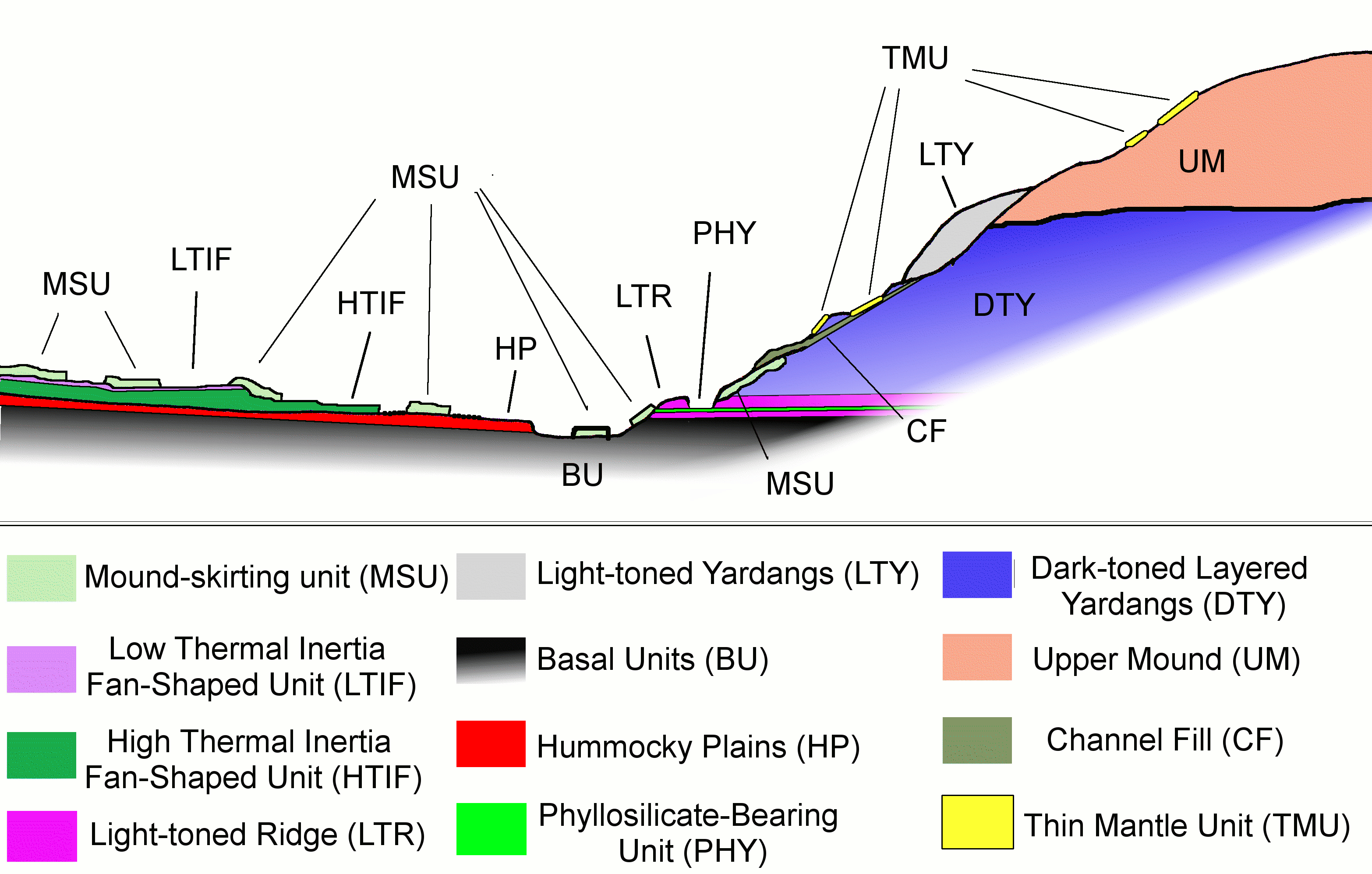
With the Anderson and Bell diagram easily to hand could somebody clarify for me which geologic unit we actually landed on? Bradbury Landing is located beyond the outer margin of the HTIF yet the rocks on the traverse have been identified as fan deposits. So did we land on a detached portion of LTIF? A patch of MSU?
|
|
|
|
|
Nov 30 2012, 07:14 PM
Post
#100
|
|
|
Founder Group: Chairman Posts: 14433 Joined: 8-February 04 Member No.: 1 |
We're (I think) in the area where the HP, HTIF and LTIF all meet - that three way junction at Glenelg. I'm guessing we landed on LTIF. Broken up fan deposites with lots of sand/fines etc would show up as low TI I would expect ( which is what we've seen) The brighter material to the N/E of us is the HTIF I believe. When we head south, we'll be on HP.
|
|
|
|
|

|
Lo-Fi Version | Time is now: 4th June 2024 - 11:09 PM |
|
RULES AND GUIDELINES Please read the Forum Rules and Guidelines before posting. IMAGE COPYRIGHT |
OPINIONS AND MODERATION Opinions expressed on UnmannedSpaceflight.com are those of the individual posters and do not necessarily reflect the opinions of UnmannedSpaceflight.com or The Planetary Society. The all-volunteer UnmannedSpaceflight.com moderation team is wholly independent of The Planetary Society. The Planetary Society has no influence over decisions made by the UnmannedSpaceflight.com moderators. |
SUPPORT THE FORUM Unmannedspaceflight.com is funded by the Planetary Society. Please consider supporting our work and many other projects by donating to the Society or becoming a member. |
|