Venus Map with Feature Names |

  |
Venus Map with Feature Names |
 Feb 25 2012, 08:26 PM Feb 25 2012, 08:26 PM
Post
#1
|
||
 Senior Member  Group: Members Posts: 1639 Joined: 5-March 05 From: Boulder, CO Member No.: 184 |
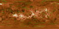
Here is a map of Venus I had put together (recall this collaboration with Emily L. and Calvin Hamilton), with the feature names now added.
Full Resolution: http://laps.noaa.gov/albers/sos/features/c..._180_center.png That's the latest, Steve -------------------- Steve [ my home page and planetary maps page ]
|
|
 |
 
|
|
|
Feb 25 2012, 08:41 PM
Post
#2
|
||
|
Senior Member Group: Members Posts: 1639 Joined: 5-March 05 From: Boulder, CO Member No.: 184 |
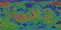
Using a shaded relief map we get another view. Might be better with a different feature color though:
Full Resolution: http://laps.noaa.gov/albers/sos/features/c..._180_center.png Steve -------------------- Steve [ my home page and planetary maps page ]
|
|
|
|
|
|
|
Feb 26 2012, 12:41 AM
Post
#3
|
|
|
Member Group: Members Posts: 890 Joined: 18-November 08 Member No.: 4489 |
if you are interested i have a 13.4 Gig C1 destriped and inpainted map i am almost done with
169000x84500 map |
|
|
|
|
Feb 26 2012, 04:05 PM
Post
#4
|
|
|
Senior Member Group: Members Posts: 1639 Joined: 5-March 05 From: Boulder, CO Member No.: 184 |
Yes, that would be nice to take a look at your higher resolution map. I recall that the data Emily had given me was intrinsically at a higher resolution than what I have used so far.
The features at present are plotted only if larger than 750-1500km, depending on feature type. These thresholds can be experimented with if one wants more names of smaller features. I also posted a transparent PNG file, so the feature overlay can be added to any map: http://laps.noaa.gov/albers/sos/features/overlay -------------------- Steve [ my home page and planetary maps page ]
|
|
|
|
|
Feb 27 2012, 05:51 AM
Post
#5
|
|
|
Member Group: Members Posts: 890 Joined: 18-November 08 Member No.: 4489 |
here is a link to a 16384x8192 pgm
82.0 MB (86031088 bytes) -- yes there is advertising -- http://www.zshare.net/download/9916352888d55b30/ it is a reduced down to 45.51 ppd from the 469.4485 ppd of the C1 |
|
|
|
|
Feb 28 2012, 12:01 AM
Post
#6
|
|
|
Member Group: Members Posts: 890 Joined: 18-November 08 Member No.: 4489 |
if you can not get to the 16 k map
some idiot did a DMCA clam that it was there file it was removed o grounds that some random person ( or bot) sent a DMCA if needed i can upload a new copy |
|
|
|
|
Mar 15 2013, 12:16 PM
Post
#7
|
|
 Member Group: Members Posts: 796 Joined: 27-February 08 From: Heart of Europe Member No.: 4057 |
I just finished my biggest work ever - topographic map of Venus.
Basic map description is directly in the map. For now, it's available only in reduced (50% of original size) and splitted jpg versions (61% and 80% of original size), mainly due to Picassa size limitations. If someone wants full PDF version of the map (~100 MB), send me a message (via UMSF message system or email). I will be glad for any constructive criticism and informations about errors. 
-------------------- |
|
|
|
|
Mar 15 2013, 02:47 PM
Post
#8
|
|
 Senior Member Group: Admin Posts: 4763 Joined: 15-March 05 From: Glendale, AZ Member No.: 197 |
Amazing!
(now Google Earth can add another planet) -------------------- If Occam had heard my theory, things would be very different now.
|
|
|
|
|
Mar 15 2013, 03:23 PM
Post
#9
|
|
|
Merciless Robot Group: Admin Posts: 8784 Joined: 8-December 05 From: Los Angeles Member No.: 602 |
Stunning, Daniel!

-------------------- A few will take this knowledge and use this power of a dream realized as a force for change, an impetus for further discovery to make less ancient dreams real.
|
|
|
|
|
Mar 15 2013, 03:50 PM
Post
#10
|
|
|
Solar System Cartographer Group: Members Posts: 10166 Joined: 5-April 05 From: Canada Member No.: 227 |
Yes, that is superb.
Phil -------------------- ... because the Solar System ain't gonna map itself.
Also to be found posting similar content on https://mastodon.social/@PhilStooke Maps for download (free PD: https://upload.wikimedia.org/wikipedia/comm...Cartography.pdf NOTE: everything created by me which I post on UMSF is considered to be in the public domain (NOT CC, public domain) |
|
|
|
|
Mar 15 2013, 05:52 PM
Post
#11
|
|
 Interplanetary Dumpster Diver Group: Admin Posts: 4404 Joined: 17-February 04 From: Powell, TN Member No.: 33 |
Wow. Just wow. Amazing!
-------------------- |
|
|
|
|
Mar 15 2013, 08:13 PM
Post
#12
|
|
|
Member Group: Members Posts: 890 Joined: 18-November 08 Member No.: 4489 |
machi
what did you use as the base imaging data the c3 compressed data it looks like you also removes the ~+7 degree offset vertical stripping i had fun with that using the c1 data ,as you get closer to the poles the angle gets closer to +- 90 deg. google translated the blog and answered the question |
|
|
|
|
Mar 16 2013, 03:31 PM
Post
#13
|
|
|
Member Group: Members Posts: 796 Joined: 27-February 08 From: Heart of Europe Member No.: 4057 |
Dan, Nick, Phil, Ted
Thanks! John: I used left-, right-, and stereo-look maps from Map-a-Planet. It was hard task for this application, because it lasted 5 - 10 days for the M-a-P to complete these maps. In near future I want to look on other datasets and fill some gaps. Some data I have already on disk and it looks promisingly. -------------------- |
|
|
|
|
Mar 16 2013, 05:44 PM
Post
#14
|
|
|
Member Group: Members Posts: 890 Joined: 18-November 08 Member No.: 4489 |
there is a lot of missing data
the low resolution height data is missing a lot near the poles http://pds-geosciences.wustl.edu/mgn/mgn-v...1/mg_3002/gtdr/ and the "f" and "c1,c2,c3" reduced size data from the -- the c1 i used http://pds-imaging.jpl.nasa.gov/data/mgn-v...5-midr-c1-v1.0/ with the pole archive http://pds-imaging.jpl.nasa.gov/data/mgn-v...r-v1.0/mg_0127/ but i am also using ISIS3 for that data as for the "gaps" i had it "inpaint" them most of the missing data is near the poles so in a top down "polarstereographic" i used "resynthesizer" mostly to fill in the areas a bit of code i have been using for years , since before it became a gimp plugin . a screen shot of the southpole ( aprox -45 to -90 ) -- -180/180 is in the bottom middle 
|
|
|
|
|
Mar 17 2013, 10:39 AM
Post
#15
|
|
|
Member Group: Members Posts: 796 Joined: 27-February 08 From: Heart of Europe Member No.: 4057 |
"there is a lot of missing data"
Yes, some gaps cannot be filled with real data (topography, BTW I worked with MG_3003, MG_3002 is obsolete) and in some cases it's possible. I found dataset mg_0127 after I have all maps done, so this data will be incorporated in next version. Also this version has polar stereographic projections made with G.Projector, very good program, but limited in resolution (max. output 7500×3750). For next version I want to use higher resolution data resampled to native map resolution. It looks better. And I don't want to fill bigger gaps for which real data doesn't exists simply because this map must display our current coverage of the surface of Venus. But thank you for your info about "resynthesizer", I didn't know that. -------------------- |
|
|
|
|
Mar 20 2013, 05:30 PM
Post
#16
|
|
 Senior Member Group: Members Posts: 2530 Joined: 20-April 05 Member No.: 321 |
This is downright heroic, Machi. I'd like to think that a map like this could get someone thinking about the need to go back to this world, which looks wonderfully new in your work. Incredible.
|
|
|
|
|
Mar 21 2013, 01:07 PM
Post
#17
|
|
|
Member Group: Members Posts: 796 Joined: 27-February 08 From: Heart of Europe Member No.: 4057 |
Thanks!
Yes, I hope so too. Venus or especially its surface is still not well understood and available data are not comparable to that, which we have for the Moon or Mars. For example, Magellan's altimeter had pretty low resolution. Every altimetric measurement covers area 100 to 1000 km2 large. For comparison, Mars Global Surveyor MOLA's laser spot had size under 0.1 km2. -------------------- |
|
|
|
|
Mar 25 2013, 04:32 PM
Post
#18
|
|
|
Junior Member Group: Members Posts: 20 Joined: 19-March 13 Member No.: 6897 |
Thanks so much! Incredibly professional, the best I've seen of any Venus map!
Do you have a source for the elevation data? Ideally I'm looking for something like a greyscale heightmap image (PNG or something), but I'm curious as to what your source was. |
|
|
|
|
Mar 25 2013, 05:08 PM
Post
#19
|
|
|
Member Group: Members Posts: 890 Joined: 18-November 08 Member No.: 4489 |
QUOTE Do you have a source for the elevation data? Ideally I'm looking for something like a greyscale heightmap image (PNG or something), but I'm curious as to what your source was. i can post the data i used in simple cylindrical projection from 2048 x1024 up to 65536x32768 pixels in size but it is 16 bit unsigned little endian a 4096x2048 8 bit normalized ( 0 to 255 ) png  the remapped "browse" image http://pds-geosciences.wustl.edu/mgn/mgn-v...002/gtdr/sinus/ 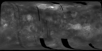
|
|
|
|
|
Mar 26 2013, 12:53 AM
Post
#20
|
|
|
Junior Member Group: Members Posts: 20 Joined: 19-March 13 Member No.: 6897 |
Thank you! I plan on using it to make a 3d model (for printing out on Shapeways). If/when I finish it, I'll share it here.
|
|
|
|
|
Mar 26 2013, 01:01 AM
Post
#21
|
|
|
Member Group: Members Posts: 890 Joined: 18-November 08 Member No.: 4489 |
QUOTE Thank you! I plan on using it to make a 3d model (for printing out on Shapeways). If/when I finish it, I'll share it here. then you WILL need a 16 bit image to start with there is a PDS ( .img) Blender 2.6 import tool that takes a PDS DEM and converts it to a sphere or you can use say a perl script to convert the 2d x,y,z( px value) into 3d x,y,z |
|
|
|
|
Mar 26 2013, 01:09 AM
Post
#22
|
|
|
Junior Member Group: Members Posts: 20 Joined: 19-March 13 Member No.: 6897 |
Thanks, but I think this will work for now. 256 levels isn't too bad for just a bumpy sphere (it will be tessellated anyway); it worked fine for Mars:
http://www.thingiverse.com/thing:26311 EDIT: For clarity, I didn't make that Mars object. |
|
|
|
|
Mar 26 2013, 02:02 AM
Post
#23
|
|
|
Member Group: Members Posts: 796 Joined: 27-February 08 From: Heart of Europe Member No.: 4057 |
Robotbeat:
If you want elevation data as DEM, then I recommend you DEMs from MG_3003 dataset. Or you can download shape file, which Mark Wieczorek did. -------------------- |
|
|
|
|
Nov 28 2013, 08:40 AM
Post
#24
|
|
|
Member Group: Members Posts: 796 Joined: 27-February 08 From: Heart of Europe Member No.: 4057 |
Because of the practically unlimited account which I have now on the Flickr, I've uploaded full version of my topographic map of Venus.
Full PDF is available here - Topographic map of Venus - PDF. 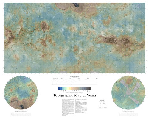 EDIT(22.1.2022): Updated PDF link. Old one didn't work due to Google's security update. -------------------- |
|
|
|
|
Nov 28 2013, 09:01 AM
Post
#25
|
|
|
Member Group: Members Posts: 890 Joined: 18-November 08 Member No.: 4489 |
That PDF is 97 meg
so if you have a slow connection.... ADMIN: The version on Flickr is 57mb |
|
|
|
|
Nov 28 2013, 11:33 AM
Post
#26
|
|
|
Member Group: Members Posts: 796 Joined: 27-February 08 From: Heart of Europe Member No.: 4057 |
Yep, sorry for that. Both PDF and jpg are really big (~100 and ~60 MB).
I had problems with PDF version in Adobe Acrobat, but it works without problems in Sumatra or SMART viewer. -------------------- |
|
|
|
|
Nov 28 2013, 06:03 PM
Post
#27
|
|
|
Merciless Robot Group: Admin Posts: 8784 Joined: 8-December 05 From: Los Angeles Member No.: 602 |
Fantastically detailed & dedicated work, Daniel. Spectacular!!!

-------------------- A few will take this knowledge and use this power of a dream realized as a force for change, an impetus for further discovery to make less ancient dreams real.
|
|
|
|
|
Nov 28 2013, 08:22 PM
Post
#28
|
|
 Member Group: Members Posts: 106 Joined: 26-September 05 Member No.: 508 |
Very beautiful and useful.
|
|
|
|
|
Nov 28 2013, 10:40 PM
Post
#29
|
|
 Senior Member Group: Members Posts: 1088 Joined: 19-February 05 From: Close to Meudon Observatory in France Member No.: 172 |
QUOTE (machi @ Nov 28 2013, 09:40 AM)  Because of the practically unlimited account which I have now on the Flickr, I've uploaded full version of my topographic map of Venus. What a GORGEOUS map !!! CONGRATULATIONS !!! Thanks to you Machi, we have also solved an old mistery about Venus : its maximum elevation is 12,177 m (on Maxwell Mountains). Thanks a lot ! 
|
|
|
|
|
Nov 29 2013, 12:18 PM
Post
#30
|
|
|
Member Group: Members Posts: 796 Joined: 27-February 08 From: Heart of Europe Member No.: 4057 |
You're welcome!
Regarding to every elevation on the map, one must be careful, because Magellan's data are pretty bad in comparison with for example MGS's MOLA laser altimeter. Resolution of radar altimeter was pretty low (one spot covers 100 - 1000 km2!) and interpretation of data in diverse terrain really isn't straightforward. Theoretically radar is better for peaks with its threshold signal altimetry than for lowlands with complex terrain where data are sometimes really messy because of multiple reflections from terrain. I wrote more about it on my blog, but you must use google translator. Overall Magellan's data for Venus are comparable to Viking's data for Mars so I recommend to treat them in the same way (as data with great uncertainty). So generally our understanding of the surface of Venus is similar as our understanding of the surface of Mars in late 70's - early 80's. -------------------- |
|
|
|
|
Nov 30 2013, 07:57 PM
Post
#31
|
|
|
Interplanetary Dumpster Diver Group: Admin Posts: 4404 Joined: 17-February 04 From: Powell, TN Member No.: 33 |
Wow, incredible! Brilliant work.
-------------------- |
|
|
|
|
Nov 30 2013, 09:26 PM
Post
#32
|
|
 IMG to PNG GOD Group: Moderator Posts: 2251 Joined: 19-February 04 From: Near fire and ice Member No.: 38 |
Wow!!! I almost feel like I'm looking at a completely new planet. It's easy to spend big amounts of time just scrolling through the map and exploring the various surface features.
|
|
|
|
|
Dec 2 2014, 12:35 AM
Post
#33
|
|
|
Newbie Group: Members Posts: 1 Joined: 11-October 14 Member No.: 7280 |
Hi John,
Would it be convenient for you to upload a new copy of your map? It sounds like it's very detailed, and like Daniel's recent map, would probably make for fascinating viewing. I recently printed out and laminated a large copy of Daniel's map and hung it on the wall of my astro/geol lab classroom - looks nice! If it's not too much trouble for you to re-upload your map, I'd be curious to examine it. (I was never quite able to figure out how to get your hi-res Venus textures to display in Celestia, but it sounds like the map to which you're referring shows essentially the same level of detail.) I certainly understand if it's not convenient to do that for a single request like this, and I also apologize if it's poor etiquette on my part to ask for a big image like this, when I'm so new to unmannedspaceflight. Thanks for your hard work! - Marek QUOTE (JohnVV @ Feb 27 2012, 04:01 PM) if you can not get to the 16 k map some idiot did a DMCA clam that it was there file it was removed o grounds that some random person ( or bot) sent a DMCA if needed i can upload a new copy |
|
|
|
|
Dec 2 2014, 01:44 AM
Post
#34
|
|
|
Member Group: Members Posts: 890 Joined: 18-November 08 Member No.: 4489 |
QUOTE (I was never quite able to figure out how to get your hi-res Venus textures to display in Celestia, you use what is called a VT ( virtual texture ) my celestia VT is here http://celestiamotherlode.net/catalog/show...p?addon_id=1070 for the FULL res you need to download EVERYTHING ( levels 0 through 7 ) this is not the best forum for that discussion ,have a look over at Celestialmatters . http://forum.celestialmatters.org/ ( replacing the dead shatters.net forum) as to the full res image 131072 x 65536 pixels it is a slightly resized version of the C1data ( 168,876 x 84,438 pixels ) http://pds-imaging.jpl.nasa.gov/data/mgn-v...5-midr-c1-v1.0/ a crop around a rather well known area -in orthographic projection ( full res) 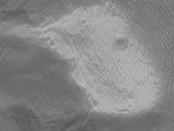 if the "imagbox" clickable image dose not work -- picassa https://plus.google.com/u/0/photos/10269590...901291398562941 right now ( i am look at my storage archive ) i have a xz compressed copy in vips image format AND a isis3 cub file the software i use for very large images is vips and it's GUI nip2 http://www.vips.ecs.soton.ac.uk/index.php?title=VIPS the .v format is a RAW with a 64 bit header that describes the image size and format ( and can be imported into ISIS3 using "raw2isis") the compressed archive is 4.5 Gig the uncompressed image is 8.0 Gig i can post it to my Google drive BUT in its current format you will need to be able to Uncompres the XZ compression and isis or imagemagick can "fudge" the vips format as a raw +64 bit image or use vips ( nip2 installs on Linux, mac and windows ) or I can resize it and use a different format like to a ppm or pgm or a isis3 cub or any gis format that GDAL supports |
|
|
|
|
Dec 4 2014, 02:46 AM
Post
#35
|
|
|
Member Group: Members Posts: 890 Joined: 18-November 08 Member No.: 4489 |
here is a link to a black and white 64 pixels per degree map
Simple cylindrical format 64ppd.Venus.pgm.zip 184.9 meg the below link is no longer a working link those that need it have it https://drive.google.com/file/d/0B6ZYAd08tZ...iew?usp=sharing 23040x11520 px. ------ 90 north ------ -180 to - o - to 180 ------ 90 South ------ the pdf " VenusMap15.3.2013i.pdf" was 53.4 pixels per degree |
|
|
|
|

|
Lo-Fi Version | Time is now: 24th May 2024 - 12:20 AM |
|
RULES AND GUIDELINES Please read the Forum Rules and Guidelines before posting. IMAGE COPYRIGHT |
OPINIONS AND MODERATION Opinions expressed on UnmannedSpaceflight.com are those of the individual posters and do not necessarily reflect the opinions of UnmannedSpaceflight.com or The Planetary Society. The all-volunteer UnmannedSpaceflight.com moderation team is wholly independent of The Planetary Society. The Planetary Society has no influence over decisions made by the UnmannedSpaceflight.com moderators. |
SUPPORT THE FORUM Unmannedspaceflight.com is funded by the Planetary Society. Please consider supporting our work and many other projects by donating to the Society or becoming a member. |
|