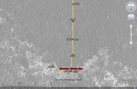
The western route, 5th leg after stop at Absecon / Reeds Bay |

  |
The western route, 5th leg after stop at Absecon / Reeds Bay |
 Jul 11 2009, 05:57 PM Jul 11 2009, 05:57 PM
Post
#1
|
||
|
Senior Member  Group: Moderator Posts: 4279 Joined: 19-April 05 From: .br at .es Member No.: 253 |
Time for a new thread.
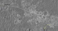
After moving southwards for ages, the "detour" by the western path has started with a 60+ meters drive on sol 1942.
There are no images yet --they should be available on the next update-- so this image was calculated solely based on the rover's mobility info. I'll update the route map later. |
|
 |
 
|
|
|
Jul 12 2009, 03:03 AM
Post
#2
|
|
|
Member Group: Members Posts: 311 Joined: 31-August 05 From: Florida & Texas, USA Member No.: 482 |
QUOTE (Tesheiner @ Jul 11 2009, 11:57 AM)  After moving southwards for ages, the "detour" by the western path has started with a 60+ meters drive on sol 1942. Whoa, didn't realize Oppy was ready to move! I thought the integration at Absecon would take a few more sols. Kinda sad that it looks like we won't get to see the small Talisman crater on the approach. Is there a projected path for the western route (ustrax's route was amazingly prescient, so now I'm lost). |
|
|
|
|
Jul 12 2009, 05:18 AM
Post
#3
|
|
|
Member Group: Members Posts: 146 Joined: 31-October 08 Member No.: 4473 |
So, on this last leg to the Martian west, across mostly pavement, what were the Right Front wheel's currents like?
|
|
|
|
|
Jul 12 2009, 08:46 AM
Post
#4
|
|
 Senior Member Group: Moderator Posts: 2262 Joined: 9-February 04 From: Melbourne - Oz Member No.: 16 |
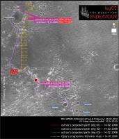
QUOTE (Marz @ Jul 12 2009, 04:03 AM) Is there a projected path for the western route (ustrax's route was amazingly prescient, so now I'm lost). I made a quick guess here a while back. I don't have Ustrax's gift though.  The 'official' route hasn't been made public yet. James -------------------- |
|
|
|
|
Jul 12 2009, 03:34 PM
Post
#5
|
|
|
Member Group: Members Posts: 530 Joined: 21-March 06 From: Canada Member No.: 721 |
I thought we would have had a revised TraxMap ™ by now.
|
|
|
|
|
Jul 13 2009, 08:49 AM
Post
#6
|
||
 Special Cookie Group: Members Posts: 2168 Joined: 6-April 05 From: Sintra | Portugal Member No.: 228 |
QUOTE (BrianL @ Jul 12 2009, 04:34 PM) I thought we would have had a revised TraxMap ™ by now. By your special request...
Paths converge once more...not in the direction I expected (no-more-spines please!) but the important thing is that...we're roving!  -------------------- "Ride, boldly ride," The shade replied, "If you seek for Eldorado!"
Edgar Alan Poe |
|
|
|
|
|
|
Jul 13 2009, 11:52 AM
Post
#7
|
||
 Senior Member Group: Admin Posts: 3108 Joined: 21-December 05 From: Canberra, Australia Member No.: 615 |
Ustrax: "...not in the direction I expected..."
That got me thinking about taking the western route... 
Just for laughs folks. I'm sure that Oppy doesn't think that there are "settlements over there". 
|
|
|
|
|
|
|
Jul 13 2009, 01:21 PM
Post
#8
|
|
|
Member Group: Members Posts: 530 Joined: 21-March 06 From: Canada Member No.: 721 |
I meant really revised, Rui. What's your take on where the westward route will run?
|
|
|
|
|
Jul 13 2009, 02:24 PM
Post
#9
|
||
|
Special Cookie Group: Members Posts: 2168 Joined: 6-April 05 From: Sintra | Portugal Member No.: 228 |
QUOTE (BrianL @ Jul 13 2009, 02:21 PM) I meant really revised, Rui. What's your take on where the westward route will run? Haven't tought about that Brian...here's the original image of my proposed route with a rough sketch of the westward route in orange...:
I still prefer the Eastward one...  -------------------- "Ride, boldly ride," The shade replied, "If you seek for Eldorado!"
Edgar Alan Poe |
|
|
|
|
|
|
Jul 13 2009, 04:36 PM
Post
#10
|
||
 Senior Member Group: Members Posts: 1887 Joined: 20-November 04 From: Iowa Member No.: 110 |
nice view
|
|
|
|
|
|
|
Jul 13 2009, 05:32 PM
Post
#11
|
|
|
Member Group: Members Posts: 713 Joined: 30-March 05 Member No.: 223 |
QUOTE (MarkG @ Jul 12 2009, 07:18 AM) So, on this last leg to the Martian west, across mostly pavement, what were the Right Front wheel's currents like? I would be interested in the answer to that question, too ... |
|
|
|
|
Jul 13 2009, 05:49 PM
Post
#12
|
||
 The Poet Dude Group: Moderator Posts: 5551 Joined: 15-March 04 From: Kendal, Cumbria, UK Member No.: 60 |
You just beat me to it, Alan. You're right, fantastic view!
-------------------- |
|
|
|
|
|
|
Jul 13 2009, 06:21 PM
Post
#13
|
|
|
Member Group: Members Posts: 530 Joined: 21-March 06 From: Canada Member No.: 721 |
<clink> <clink>
What are those hills and how far away are they? Have they always been visible and I just haven't been paying attention? Edit: Wait a minute, what direction is that? If that's east, then obviously that's our goal. When I first looked at it, I thought these were some new shots in the direction we're heading. |
|
|
|
|
Jul 13 2009, 06:29 PM
Post
#14
|
|
|
Special Cookie Group: Members Posts: 2168 Joined: 6-April 05 From: Sintra | Portugal Member No.: 228 |
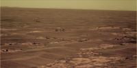
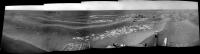
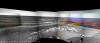
QUOTE (BrianL @ Jul 13 2009, 07:21 PM) <clink> <clink> Oh boy...this is going to be a long night...ahahah http://www.unmannedspaceflight.com/index.p...st&id=18432 From my ignorant perspective (I am sure James will come up with the right answer...) we can see Cook near the center and elevation to its left (Molyneaux) , we can also see the twin peaks (Banks and Solander) on the North rim but what's new are all those hills to the left... Are we seing the West/South part of the rim? Edgecombe and friends?
-------------------- "Ride, boldly ride," The shade replied, "If you seek for Eldorado!"
Edgar Alan Poe |
|
|
|
|
Jul 13 2009, 06:52 PM
Post
#15
|
|
 Senior Member Group: Members Posts: 4251 Joined: 17-January 05 Member No.: 152 |
Thanks for the heads up, guys, these are great views!
The most prominent peaks on the far left in these images are on the near (west) rim of Endeavour. All the fainter peaks are the rim of Iazu crater behind Endeavour. We've had similar views before, but the air is looking clearer now. Compare the latest view: http://qt.exploratorium.edu/mars/opportuni...PGP2599L5M1.JPG with the view from sol 1898: http://marsrovers.jpl.nasa.gov/gallery/all...3AP2356L6M1.JPG |
|
|
|
|
Jul 13 2009, 07:00 PM
Post
#16
|
|
|
Special Cookie Group: Members Posts: 2168 Joined: 6-April 05 From: Sintra | Portugal Member No.: 228 |
Fred, if that's Iazu, let's wrap this Endeavour story fast...
How tall is that martian beast?... 
-------------------- "Ride, boldly ride," The shade replied, "If you seek for Eldorado!"
Edgar Alan Poe |
|
|
|
|
Jul 13 2009, 07:35 PM
Post
#17
|
|
|
Senior Member Group: Moderator Posts: 2262 Joined: 9-February 04 From: Melbourne - Oz Member No.: 16 |
Fred's right that is Iazu again - great view.
As to the height, Google Earth says that the peaks are 200 - 300 m above the surrounding plain. In that image the peaks are about 10 pixels high - at roughly 40km that makes what we can see the top 100m or so. -------------------- |
|
|
|
|
Jul 13 2009, 08:20 PM
Post
#18
|
|
|
Senior Member Group: Moderator Posts: 4279 Joined: 19-April 05 From: .br at .es Member No.: 253 |
Wow, what a view!
 I saw that sequence (Iazu's pancam) in the plan but forgot to check it afterwards. The current view at the horizon is, imo, the most exciting since the beginning of this mission. |
|
|
|
|
Jul 13 2009, 08:25 PM
Post
#19
|
|
|
Special Cookie Group: Members Posts: 2168 Joined: 6-April 05 From: Sintra | Portugal Member No.: 228 |
James, sorry for asking but, that's not all Iazu, right? There are some features to the right of Cook that belong to Endeavour, or am I wrong?
I was taking this previous image as a reference: http://photojournal.jpl.nasa.gov/figures/PIA11837_fig1.jpg -------------------- "Ride, boldly ride," The shade replied, "If you seek for Eldorado!"
Edgar Alan Poe |
|
|
|
|
Jul 13 2009, 08:39 PM
Post
#20
|
|
|
The Poet Dude Group: Moderator Posts: 5551 Joined: 15-March 04 From: Kendal, Cumbria, UK Member No.: 60 |
Craig Covault - speaking live on SpaceflightNow's video coverage of the shuttle launch - has just been saying that MRO has found *clays* inside Endeavour crater... and as (paraphrasing here) clays don't form/last long in acidic water, this suggests that the water there was, for at least some time, less acidic than previously thought...
Anyone know anything about this..? -------------------- |
|
|
|
|
Jul 13 2009, 09:29 PM
Post
#21
|
|
|
Senior Member Group: Members Posts: 4251 Joined: 17-January 05 Member No.: 152 |
QUOTE (ustrax @ Jul 13 2009, 09:25 PM) that's not all Iazu, right? Right. See this post if you need convincing... |
|
|
|
|
Jul 14 2009, 02:00 AM
Post
#22
|
|
 Senior Member Group: Members Posts: 3419 Joined: 9-February 04 From: Minneapolis, MN, USA Member No.: 15 |
Stu, my understanding is that the "clays" that MRO has been discovering are the phylosilicates that have been discussed at length, especially in the site selection deliberations for MSL.
I'd have the think that any clays found within Endeavour would have to be remnants of earlier aqueous conditions than those which were involved in laying down the Meridiani sulfate sandstones. And considering there must be pieces of the crust underlying those sandstone deposits in the walls of Endeavour, I guess that's not terribly surprising. Now we need to really hope and pray that Oppy can make it to some of the clay deposits and give them a careful examination. For one thing, clays are the most likely places to find fossilized life remnants, especially bacterial fossils. While Oppy is not all that well equipped to look for anything like that, it could very likely constrain the possibilities in a favorable manner. Take *real* good care of Oppy for us, guys... now, more than ever, it seems the payoff if we get to Endeavour could be truly astounding. -the other Doug -------------------- The trouble ain't that there is too many fools, but that the lightning ain't distributed right. -Mark Twain
|
|
|
|
|
Jul 14 2009, 05:59 AM
Post
#23
|
|
 Senior Member Group: Members Posts: 2228 Joined: 1-December 04 From: Marble Falls, Texas, USA Member No.: 116 |
Yeah. When Endeavour became the goal, I perused the raw mineralogical maps available from MRO. I found a very small patch of possible phyllosilicates on the far, eastern side of the crater. It would be significant if newer imagery, or reprocessed imagery was indicating phyllosilicates to be more common.
-------------------- ...Tom
I'm not a Space Fan, I'm a Space Exploration Enthusiast. |
|
|
|
|
Jul 15 2009, 08:57 PM
Post
#24
|
||
|
Senior Member Group: Moderator Posts: 4279 Joined: 19-April 05 From: .br at .es Member No.: 253 |
Today was another driving sol, where almost 70m were covered in a WNW heading.
I would expect a heading change to NW on the next two or three driving sols to avoid some "purgatoids" due west.
PS: Map update tomorrow, if time permits. |
|
|
|
|
|
|
Jul 16 2009, 05:54 AM
Post
#25
|
|
|
Senior Member Group: Members Posts: 2228 Joined: 1-December 04 From: Marble Falls, Texas, USA Member No.: 116 |
I realized that I should have better referenced the CRISM imagery I referred to in my previous post. The raw imagery I referred to is here. Apparently my recollection of the location was faulty. The small anomaly I described was not on the far, eastern side of the crater. It is closer to the center of the crater. It is on the far, eastern side of the image.
Of course, all the normal cautions apply to any interpretations of such non-calibrated imagery. -------------------- ...Tom
I'm not a Space Fan, I'm a Space Exploration Enthusiast. |
|
|
|
|
Jul 16 2009, 08:31 AM
Post
#26
|
|
|
Senior Member Group: Members Posts: 2922 Joined: 14-February 06 From: Very close to the Pyrénées Mountains (France) Member No.: 682 |
I while ago somebody wrote, I think it was Phil, that we were heading to higher terrain due in a few kilometers (2?).
Does somebody know whether it's still the case or can we say the western route is just flat for a while? You'll understand that I'm looking for a vintage high place to get a better view. -------------------- |
|
|
|
|
Jul 16 2009, 02:12 PM
Post
#27
|
|
 Senior Member Group: Admin Posts: 4763 Joined: 15-March 05 From: Glendale, AZ Member No.: 197 |
QUOTE (climber @ Jul 16 2009, 01:31 AM) You'll understand that I'm looking for a vintage high place to get a better view. millésime? sur Mars? -------------------- If Occam had heard my theory, things would be very different now.
|
|
|
|
|
Jul 16 2009, 03:38 PM
Post
#28
|
|
|
Senior Member Group: Members Posts: 2922 Joined: 14-February 06 From: Very close to the Pyrénées Mountains (France) Member No.: 682 |
QUOTE (ElkGroveDan @ Jul 16 2009, 04:12 PM) millésime? sur Mars? ...and we'll call it (Avril) Lavigne... -------------------- |
|
|
|
|
Jul 16 2009, 09:24 PM
Post
#29
|
|
|
Member Group: Members Posts: 139 Joined: 14-October 05 From: Toronto, Canada Member No.: 529 |
Ahhh....a touch of Canadian content...

-------------------- -- Robin
|
|
|
|
|
Jul 16 2009, 09:47 PM
Post
#30
|
|
|
Solar System Cartographer Group: Members Posts: 10184 Joined: 5-April 05 From: Canada Member No.: 227 |
Can't have too much of that.
Phil -------------------- ... because the Solar System ain't gonna map itself.
Also to be found posting similar content on https://mastodon.social/@PhilStooke Maps for download (free PD: https://upload.wikimedia.org/wikipedia/comm...Cartography.pdf NOTE: everything created by me which I post on UMSF is considered to be in the public domain (NOT CC, public domain) |
|
|
|
|
Jul 19 2009, 12:47 PM
Post
#31
|
|
 Member Group: Members Posts: 578 Joined: 5-November 04 From: Denmark Member No.: 107 |
Some good news in the latest update
http://marsrovers.nasa.gov/mission/status.html#opportunity QUOTE Opportunity began moving again with a 67-meter (220-foot) drive. The right-front wheel motor current showed some improvement from the actuator resting and extra mobility heating.
The rover performed another long drive on Sol 1946 (July 15, 2009), covering over 70 meters (230 feet). Again, the right front wheel currents showed continued improvement. -------------------- "I want to make as many people as possible feel like they are part of this adventure. We are going to give everybody a sense of what exploring the surface of another world is really like"
- Steven Squyres |
|
|
|
|
Jul 19 2009, 09:17 PM
Post
#32
|
|
|
Special Cookie Group: Members Posts: 2168 Joined: 6-April 05 From: Sintra | Portugal Member No.: 228 |
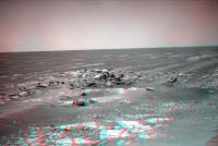
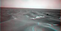
Hey, are these marks left my Oppy's wheels? I don't remember seing this before:
http://qt.exploratorium.edu/mars/opportuni...FFP2514R1M1.JPG -------------------- "Ride, boldly ride," The shade replied, "If you seek for Eldorado!"
Edgar Alan Poe |
|
|
|
|
Jul 19 2009, 11:02 PM
Post
#33
|
|
|
Member Group: Members Posts: 293 Joined: 22-September 08 From: Spain Member No.: 4350 |
She has done that before. The bedrock isn't very rocky.
|
|
|
|
|
Jul 20 2009, 06:35 AM
Post
#34
|
|
|
Senior Member Group: Moderator Posts: 4279 Joined: 19-April 05 From: .br at .es Member No.: 253 |
Check the navcams taken during sol 1950: http://qt.exploratorium.edu/mars/opportuni...cam/2009-07-19/
There are a few mini-craters in sight. The one to the right (NW) was named "Alvin". |
|
|
|
|
Jul 20 2009, 11:48 AM
Post
#35
|
|||
|
The Poet Dude Group: Moderator Posts: 5551 Joined: 15-March 04 From: Kendal, Cumbria, UK Member No.: 60 |
Not sure which crater this is... taken my eye off Oppy during all the LRO drooling, I'll be honest!... but interesting...
And some nice little rocks for Oppy to snuffle around in, too...
-------------------- |
||
|
|
|
||
|
Jul 20 2009, 04:26 PM
Post
#36
|
||
|
Senior Member Group: Moderator Posts: 4279 Joined: 19-April 05 From: .br at .es Member No.: 253 |
That's Alvin. Here's a navcam mosaic made with those pictures to put it in context.
BTW, has anybody seen Cape St. Mary these last sols? Is it still visible? |
|
|
|
|
|
|
Jul 20 2009, 05:00 PM
Post
#37
|
||
|
Senior Member Group: Members Posts: 4251 Joined: 17-January 05 Member No.: 152 |
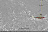
I've been watching Cape St. Mary (Beacon) in the rear view mirror. Our last definite sighting was sol 1942 navcam, though it was getting a bit hard to make out. I've marked it in this crop:
There've been north-pointing navcams since, but I can't make CSM out unambiguously (determining the exact azimuth might help). The lighting is bad (low contrast between sky and ground), but it may be that we're losing it due to topography. We're certainly no farther from CSM than we were at the last sightings. The last good view was sol 1938 pancam: http://marsrovers.jpl.nasa.gov/gallery/all...PGP2286L1M1.JPG edit: this pancam view is so good (at half resolution yet), that given favourable topography we should be able to see CSM for a very long time to come, even from Endeavour (at least from the higher peaks that were visible from Victoria). |
|
|
|
|
|
|
Jul 20 2009, 05:12 PM
Post
#38
|
|
|
Senior Member Group: Moderator Posts: 4279 Joined: 19-April 05 From: .br at .es Member No.: 253 |
There was an "albedo pan" taken during sol 1949 but I don't know if it's already downlinked or not. We should try locating the cape in those pancams; the heading is... (checking in Google Mars) ... 16 degrees CW.
And speaking again about the mini-craters, the one to the left is "Dolphin". |
|
|
|
|
Jul 21 2009, 02:36 PM
Post
#39
|
||
|
The Poet Dude Group: Moderator Posts: 5551 Joined: 15-March 04 From: Kendal, Cumbria, UK Member No.: 60 |
Others will do better, I'm sure. I just fancied having a go
-------------------- |
|
|
|
|
|
|
Jul 21 2009, 02:38 PM
Post
#40
|
||
|
The Poet Dude Group: Moderator Posts: 5551 Joined: 15-March 04 From: Kendal, Cumbria, UK Member No.: 60 |
... and t'other one...
-------------------- |
|
|
|
|
|
|
Jul 22 2009, 01:18 AM
Post
#41
|
|
|
Senior Member Group: Members Posts: 3419 Joined: 9-February 04 From: Minneapolis, MN, USA Member No.: 15 |
Hmmm... how much of what looks like good flat pavement-stone rock from MRO is actually this kind of pile-up of (relatively recently-emplaced, at least recently enough not to have eroded down to flat yet) jumbled sandstone?
Hopefully, not a lot...  -the other Doug -------------------- The trouble ain't that there is too many fools, but that the lightning ain't distributed right. -Mark Twain
|
|
|
|
|
Jul 22 2009, 03:30 AM
Post
#42
|
|
|
Member Group: Members Posts: 233 Joined: 21-April 05 Member No.: 328 |
Stu, very nice job on the small meteor craters. Can you imagine standing nearby when one of those babies hits?!? Any guess as to the size of the original meteorite? I'm thinking about 8 inches in diameter . . .
|
|
|
|
|
Jul 22 2009, 11:10 AM
Post
#43
|
|
|
Senior Member Group: Moderator Posts: 4279 Joined: 19-April 05 From: .br at .es Member No.: 253 |
I just checked the info from yestersol drive (1952) to find out that Opportunity moved 20m back on her own track.
 Not only that but also the nav/pancam images taken after-drive to plan the next one were pointed back towards the position she were on sol 1947. Perhaps this path was not a safe one? In another topic: the 17km mark was crossed near the end of this drive. |
|
|
|
|
Jul 22 2009, 11:38 AM
Post
#44
|
||
|
Senior Member Group: Members Posts: 1887 Joined: 20-November 04 From: Iowa Member No.: 110 |
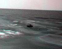
Going back for closer look at this perhaps?
From sol 1946, these images weren't downloaded until after she had driven on. |
|
|
|
|
|
|
Jul 22 2009, 01:27 PM
Post
#45
|
|
|
Member Group: Members Posts: 362 Joined: 13-April 06 From: Malta Member No.: 741 |
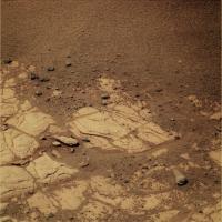
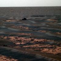
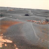
What should we call that!?looks quite big to me?
|
|
|
|
|
Jul 22 2009, 01:48 PM
Post
#46
|
|
|
Senior Member Group: Moderator Posts: 4279 Joined: 19-April 05 From: .br at .es Member No.: 253 |
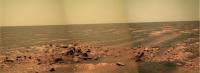
It was named "Block Island".
01946::p2532::23::13::13::0::0::2::28::pancam_Block_Island_L234567Rall |
|
|
|
|
Jul 22 2009, 03:03 PM
Post
#47
|
|
|
Member Group: Members Posts: 913 Joined: 4-September 06 From: Boston Member No.: 1102 |
Tesheiner, would it be possible put a label for Block Island on your map (even if too small to actually see on the map image)? I'm confused as to which crater it is sitting in front of. It isn't Alvin?
-------------------- |
|
|
|
|
Jul 22 2009, 03:17 PM
Post
#48
|
|
|
Senior Member Group: Members Posts: 4251 Joined: 17-January 05 Member No.: 152 |
"Block Island" is actually a ways south of the sol 1942 location:
http://marsrovers.jpl.nasa.gov/gallery/all...00P1962R0M1.JPG (And it's roughly 25 cm tall.) So that would mean some significant backtracking if that were a target. I'm baffled by this reversal. Edit: perhaps Oppy's gotten tired of seeing her destination in the rearview mirror: http://marsrovers.jpl.nasa.gov/gallery/all...NMP1760R0M1.JPG and she's revolted! 
|
|
|
|
|
Jul 22 2009, 03:45 PM
Post
#49
|
|
|
Member Group: Members Posts: 530 Joined: 21-March 06 From: Canada Member No.: 721 |
Or this is a repeat of that programming glitch that made her go one way when she meant to go the other, although one would assume they got that issue sorted out.
I'm hopeful this is a sign that the Endeavour clays have become such a high-priority target that they have decided on the shorter, presumably quicker but riskier route to increase their chances of getting there before the overriding enemy that is time ultimately results in a critical system failure that will stop Oppy dead in her tracks. In other words, move from the philosophy that "south is the way to go, and IF we get to Endeavour, that's a bonus" to "we must reach Endeavour or die trying". |
|
|
|
|
Jul 22 2009, 05:02 PM
Post
#50
|
|
|
Senior Member Group: Moderator Posts: 4279 Joined: 19-April 05 From: .br at .es Member No.: 253 |
No way that it would be another instance of the "glitch". The evidence is the "post-drive" mosaics because they are pointing WSW, same as the driving direction.
I would expect some news on the next status report in a few days, unless someone in the know posts some tidbits here. |
|
|
|
|
Jul 22 2009, 05:04 PM
Post
#51
|
|
|
Member Group: Members Posts: 362 Joined: 13-April 06 From: Malta Member No.: 741 |
So now we're sailing in the north atlantic along the northeastern US COAST...watch out for JAWS next!
|
|
|
|
|
Jul 22 2009, 06:21 PM
Post
#52
|
|
|
Member Group: Senior Member Posts: 136 Joined: 8-August 06 Member No.: 1022 |
QUOTE (Floyd @ Jul 22 2009, 07:03 AM) Tesheiner, would it be possible put a label for Block Island on your map (even if too small to actually see on the map image)? I'm confused as to which crater it is sitting in front of. It isn't Alvin? Block Island is visible in the HiRISE image, meaning it's fairly large, which is one reason we're going back. Other reason(s) I'll leave up to the reader! (more fun that way!) -Tim. |
|
|
|
|
Jul 22 2009, 07:04 PM
Post
#53
|
|
|
Senior Member Group: Members Posts: 4251 Joined: 17-January 05 Member No.: 152 |
I estimate Block Island is roughly 25 cm tall by 50 cm wide (orthogonal to our line of sight). That's assuming it's sitting at the same elevation as Oppy's wheels were, and also that the horizon was level with pancam. (Probably not horrible approximations on Meridiani!)
Could someone who has the full resolution HiRISE post a full res crop showing the area of Block Island? I estimate it's about 50 metres S or SSW from the sol 1942 location. |
|
|
|
| Guest_Sunspot_* |
Jul 22 2009, 07:06 PM
Post
#54
|
|
|
Guests |
QUOTE (alan @ Jul 22 2009, 12:38 PM) Going back for closer look at this perhaps?
Looks like a Land Rover stuck in the Sahara..... kind of
|
|
|
|
|
|
|
Jul 22 2009, 07:44 PM
Post
#55
|
|
 Member Group: Members Posts: 813 Joined: 8-February 04 From: Arabia Terra Member No.: 12 |
Great news!
This will take me more time to tweak my google earth map extension (it's proving trickier than i thought).
|
|
|
|
|
Jul 22 2009, 08:01 PM
Post
#56
|
||
 Member Group: Members Posts: 221 Joined: 25-March 05 Member No.: 217 |
Hi FredK
Here's a crop of the region I think you want. I may be wrong, can't see the rock. I can crop a different area if you wish. Roy F
Attached thumbnail(s)
|
|
|
|
|
|
|
Jul 22 2009, 08:25 PM
Post
#57
|
|
|
Member Group: Senior Member Posts: 136 Joined: 8-August 06 Member No.: 1022 |
Roy:
It's in there! -Tim. |
|
|
|
|
Jul 22 2009, 09:22 PM
Post
#58
|
|
 Member Group: Members Posts: 237 Joined: 22-December 07 From: Alice Springs, N.T. Australia Member No.: 3989 |
Would someone who can see where it is please circle it and repost the pic! Can't see it.
|
|
|
|
|
Jul 22 2009, 09:35 PM
Post
#59
|
||
|
Member Group: Senior Member Posts: 136 Joined: 8-August 06 Member No.: 1022 |
QUOTE (HughFromAlice @ Jul 22 2009, 01:22 PM) Would someone who can see where it is please circle it and repost the pic! Can't see it.
|
|
|
|
|
|
|
Jul 22 2009, 09:46 PM
Post
#60
|
|
|
Founder Group: Chairman Posts: 14433 Joined: 8-February 04 Member No.: 1 |
I can well understand why we're going to have a look. Not only does it look different to all the surrounding rock - it's also, I'd guess, the single largest rock not in a crater that Opportunity has ever seen.
|
|
|
|
|
Jul 22 2009, 09:50 PM
Post
#61
|
|
|
Member Group: Members Posts: 813 Joined: 8-February 04 From: Arabia Terra Member No.: 12 |
Wow, that's a long drive back. Whatever it is that the rover team thinks this might be has got to be a lot more interesting than another iron meteorite!
|
|
|
|
|
Jul 22 2009, 10:22 PM
Post
#62
|
|
|
Senior Member Group: Moderator Posts: 4279 Joined: 19-April 05 From: .br at .es Member No.: 253 |
|
|
|
|
|
Jul 23 2009, 12:28 AM
Post
#63
|
|
|
Member Group: Members Posts: 293 Joined: 29-August 06 From: Columbia, MD Member No.: 1083 |
Can someone summarize the reasons their taking the big west (almost northwest) turn? Is it more stable ground to drive on? Sorry if I missed this many pages back. Thanks!
|
|
|
|
|
Jul 23 2009, 12:48 AM
Post
#64
|
|
|
Merciless Robot Group: Admin Posts: 8784 Joined: 8-December 05 From: Los Angeles Member No.: 602 |
Hmm. Well, as Doug pointed out, BI is an anomaly in its own right even on cursory examination. However, Tim is hinting that there are other less obvious reasons for the close-up exam.
It sure is dark, which to me indicates that might be a relatively recent, hefty meteorite. On the other hand, it might be an ejecta block from a fresh impact in the area...say, maybe from over near the recently-more-interesting region near Endeavour? Are you guys looking for clay early?
-------------------- A few will take this knowledge and use this power of a dream realized as a force for change, an impetus for further discovery to make less ancient dreams real.
|
|
|
|
|
Jul 23 2009, 01:06 AM
Post
#65
|
|
|
Senior Member Group: Admin Posts: 4763 Joined: 15-March 05 From: Glendale, AZ Member No.: 197 |
QUOTE (nprev @ Jul 22 2009, 04:48 PM) Tim is hinting that there are other less obvious reasons for the close-up exam. Was there perhaps a tantalizing mini-TES image taken? Does it even work on Opportunity anymore? -------------------- If Occam had heard my theory, things would be very different now.
|
|
|
|
|
Jul 23 2009, 01:22 AM
Post
#66
|
|
|
Senior Member Group: Members Posts: 4251 Joined: 17-January 05 Member No.: 152 |
|
|
|
|
|
Jul 23 2009, 01:28 AM
Post
#67
|
|
|
Senior Member Group: Members Posts: 1045 Joined: 17-February 09 Member No.: 4605 |
QUOTE (fredk @ Jul 23 2009, 01:22 AM) So the attempt to clear the dusty mirror by leaving it exposed has failed? |
|
|
|
|
Jul 23 2009, 02:50 AM
Post
#68
|
|
|
Senior Member Group: Members Posts: 1045 Joined: 17-February 09 Member No.: 4605 |
QUOTE (glennwsmith @ Jul 22 2009, 03:30 AM) ... Any guess as to the size of the original meteorite? I'm thinking about 8 inches in diameter . . . Glenn, the size would depend on the meteor type and velocity. Was this a secondary? Was it at terminal velocity or faster? The link takes a lot of the effort out of 'what iffing' this question. http://www.lpl.arizona.edu/tekton/crater_c.html |
|
|
|
|
Jul 23 2009, 03:26 AM
Post
#69
|
|
|
Member Group: Members Posts: 233 Joined: 21-April 05 Member No.: 328 |
Serpens, thanks for the link to the crater diameter calculator -- it is fascinating! And I am perhaps not so far off! A 0.2 m diameter meteor of dense rock (not iron), traveling at 45 km/sec (the upper end of the range for Mars impacts), and striking "competent rock" will create a crater 3.49 m (appx. 12 feet) in diameter.
But Block Island is even more fascinating!!! Is anyone sure that's why we've turned around? |
|
|
|
|
Jul 23 2009, 04:19 AM
Post
#70
|
|
|
Member Group: Senior Member Posts: 136 Joined: 8-August 06 Member No.: 1022 |
Doug has it. It's the biggest thing not associated with a crater that we've seen. And it's not outcrop.
-Tim. |
|
|
|
|
Jul 23 2009, 05:04 AM
Post
#71
|
|
|
Merciless Robot Group: Admin Posts: 8784 Joined: 8-December 05 From: Los Angeles Member No.: 602 |
Certainly reason enough. And there I was, spinning out into left field...
-------------------- A few will take this knowledge and use this power of a dream realized as a force for change, an impetus for further discovery to make less ancient dreams real.
|
|
|
|
|
Jul 23 2009, 05:06 AM
Post
#72
|
|
|
Member Group: Members Posts: 233 Joined: 21-April 05 Member No.: 328 |
Alan, my man! What led you to this felicitous observation? Just your own curiosity about that big black rock?
|
|
|
|
|
Jul 23 2009, 05:36 AM
Post
#73
|
|
|
Senior Member Group: Members Posts: 1887 Joined: 20-November 04 From: Iowa Member No.: 110 |
Just thought 'hey that looks interesting' when MMB downloaded the images, that and 'too bad Oppy has already driven away'
I'm also wondering if it's located far enough south for Oppy to see some of the terrain to the south that's currently hidden from view. |
|
|
|
|
Jul 23 2009, 06:47 AM
Post
#74
|
|
|
Senior Member Group: Members Posts: 2228 Joined: 1-December 04 From: Marble Falls, Texas, USA Member No.: 116 |
QUOTE (tim53 @ Jul 22 2009, 11:19 PM) Doug has it. It's the biggest thing not associated with a crater that we've seen. And it's not outcrop. -Tim. I thought there was a significantly larger "erratic" boulder observed near Erebus. Some here were surprised that that one was not more closely investigated at the time. I'm not suggesting that either was a glacial erratic, only that it was an erratic boulder on Mars. -------------------- ...Tom
I'm not a Space Fan, I'm a Space Exploration Enthusiast. |
|
|
|
|
Jul 23 2009, 03:01 PM
Post
#75
|
|
|
Member Group: Members Posts: 252 Joined: 27-April 05 Member No.: 365 |
But what took the team so long to decide to turn around and go investigate BI? Someone maybe took a second look at the downloaded images a few days after their initial evaluation and raised a big flag? Would have been interesting to be a fly on the wall during that ops meeting....
|
|
|
|
|
Jul 23 2009, 03:04 PM
Post
#76
|
|
|
Senior Member Group: Members Posts: 4251 Joined: 17-January 05 Member No.: 152 |
Thanks for the maps, guys. I now measure the distance to BI to be 66 metres from the sol 1942 location. That gives a size for the rock of about 67 cm wide by 30 cm high.
The approximate size of BI would've been known before they moved away from the 1942 location - the navcams were down and the pancams were targeted. So I'm guessing that the spectral info from the BI pancam sequence was important in the decision to go back. Do the oldtimers here remember another time that they turned back to study a target? There's been backtracking due to mobility problems, but I don't recall anything like this. |
|
|
|
|
Jul 23 2009, 03:14 PM
Post
#77
|
|
|
Senior Member Group: Members Posts: 4251 Joined: 17-January 05 Member No.: 152 |
QUOTE (Burmese @ Jul 23 2009, 04:01 PM) But what took the team so long to decide to turn around and go investigate BI? To add to my post above, the BI pancam sequence only came down late Saturday. The sol 1950 drive was Sunday. So it would make sense that they didn't turn back till 1952 if the pancam sequence was the trigger. |
|
|
|
|
Jul 23 2009, 04:15 PM
Post
#78
|
|
|
Senior Member Group: Members Posts: 1887 Joined: 20-November 04 From: Iowa Member No.: 110 |
QUOTE (fredk @ Jul 23 2009, 10:04 AM) Do the oldtimers here remember another time that they turned back to study a target? There's been backtracking due to mobility problems, but I don't recall anything like this. They turned Spirit back on sol 454 when the layering at Methuselah was spotted while Spirit was attempting to drive up Husband Hill. Spirit then spent an additional two month's there. QUOTE For several months, Spirit climbed a flank of Husband Hill, the tallest in the range. The slope closely matched the angle of underlying rock layers, which made the layering difficult to detect. Spirit reached an intermediate destination, dubbed "Larry's Lookout," then continued uphill and looked back. "That was the critical moment, when it all began falling into place," Squyres said. "Looking back downhill, you can see the layering, and it suddenly starts to makes sense." http://marsrovers.jpl.nasa.gov/newsroom/pr.../20050524a.html Methuselah: http://marswatch.astro.cornell.edu/pancam_...selah_new2.html |
|
|
|
|
Jul 23 2009, 04:20 PM
Post
#79
|
||
 Senior Member Group: Members Posts: 2173 Joined: 28-December 04 From: Florida, USA Member No.: 132 |
QUOTE (CosmicRocker @ Jul 23 2009, 01:47 AM) I thought there was a significantly larger "erratic" boulder observed near Erebus.... Is this the one?
From hortonheardawho |
|
|
|
|
|
|
Jul 23 2009, 04:24 PM
Post
#80
|
|
|
Senior Member Group: Members Posts: 2173 Joined: 28-December 04 From: Florida, USA Member No.: 132 |
QUOTE (fredk @ Jul 23 2009, 10:04 AM) Do the oldtimers here remember another time that they turned back to study a target? There was talk of heading back to Erebus after leaving Victoria. At the same time, the talk was of studying cobbles out on the plain. I wonder if some on the team wished they had taken a closer look at that "erratic boulder" which looked like the Mother of All Cobbles to me. |
|
|
|
|
Jul 23 2009, 05:41 PM
Post
#81
|
|
|
Senior Member Group: Members Posts: 4251 Joined: 17-January 05 Member No.: 152 |
QUOTE (centsworth_II @ Jul 23 2009, 05:20 PM) Is this the one? Thanks for finding that. That was viewed from the Olympia site. You can see from this image that it's maybe more of a rubble pile than a boulder: http://marsrovers.jpl.nasa.gov/gallery/all...KCP2283L7M1.JPG I get around 40 by 17 cm size for it, so BI is a fair bit bigger. |
|
|
|
|
Jul 23 2009, 11:21 PM
Post
#82
|
|
|
Senior Member Group: Members Posts: 1045 Joined: 17-February 09 Member No.: 4605 |
QUOTE (fredk @ Jul 23 2009, 04:04 PM) Do the oldtimers here remember another time that they turned back to study a target? I think the only other time was for Paso Robles. But that was a short hop. |
|
|
|
|
Jul 24 2009, 12:12 AM
Post
#83
|
|
|
Senior Member Group: Members Posts: 4251 Joined: 17-January 05 Member No.: 152 |
QUOTE (serpens @ Jul 23 2009, 02:28 AM) So the attempt to clear the dusty mirror by leaving it exposed has failed? That's right, so far: QUOTE The shroud of the Mini-TES continues to be left open on scheduled sols to allow the environment to clean putative dust contamination from the elevation mirror. No improvement in Mini-TES performance has been observed so far, but the rover has seen no wind events.
|
|
|
|
|
Jul 24 2009, 03:53 AM
Post
#84
|
|
|
Senior Member Group: Members Posts: 4251 Joined: 17-January 05 Member No.: 152 |
QUOTE (Tesheiner @ Jul 20 2009, 07:35 AM) There are a few mini-craters in sight. The one to the right (NW) was named "Alvin". Could it be Alvin was a target near the crater? Here they seem to refer to that crater as "Kaiko." |
|
|
|
|
Jul 24 2009, 04:15 AM
Post
#85
|
|
|
Senior Member Group: Members Posts: 2228 Joined: 1-December 04 From: Marble Falls, Texas, USA Member No.: 116 |
QUOTE (centsworth_II @ Jul 23 2009, 10:20 AM) Is this the one? ... Yeah, I guess it is; but it appeared several times larger in my memory. -------------------- ...Tom
I'm not a Space Fan, I'm a Space Exploration Enthusiast. |
|
|
|
|
Jul 24 2009, 04:24 AM
Post
#86
|
|
|
Member Group: Members Posts: 233 Joined: 21-April 05 Member No.: 328 |
Drksywxlt, yes, the rovers have been sent on some seemingly roundabout routes to avoid bad ground, esp. since Oppy got stuck for several weeks in a sand dune. If there is one thing we have learned here at UMSF, it's that the rover team knows what it is doing.
|
|
|
|
|
Jul 24 2009, 07:01 AM
Post
#87
|
|
|
Founder Group: Chairman Posts: 14433 Joined: 8-February 04 Member No.: 1 |
I guess in the category of 'turn back to go somewhere' - the traverse of the northern rim of Victoria, only to enter at the very point we arrived must count
But there was a very good reason for that.
|
|
|
|
|
Jul 24 2009, 07:25 AM
Post
#88
|
|
|
Senior Member Group: Members Posts: 2922 Joined: 14-February 06 From: Very close to the Pyrénées Mountains (France) Member No.: 682 |
QUOTE (glennwsmith @ Jul 24 2009, 06:24 AM) if there is one thing we have learned here at UMSF, it's that the rover team knows what it is doing. Yep, and that... the rovers don't 
-------------------- |
|
|
|
|
Jul 24 2009, 08:18 AM
Post
#89
|
||
|
Senior Member Group: Moderator Posts: 4279 Joined: 19-April 05 From: .br at .es Member No.: 253 |
QUOTE (fredk @ Jul 24 2009, 05:53 AM) Could it be Alvin was a target near the crater? Here they seem to refer to that crater as "Kaiko." Mmm, strange... There were two pancam shots taken at that site, the first named Alvin pointing to the crater at the NW (right) and the second named Dolphin pointing to another one at the WSW (left). Here's an MMB snapshot with the images in context.
01950::p2385::20::9::0::0::9::1::19::pancam_Alvin_L257 01950::p2386::20::3::0::0::3::1::7::pancam_Dolphin_L257 So, perhaps it should be named Alvin/Kaiko; both are vessels used in deep sea exploration. |
|
|
|
|
|
|
Jul 24 2009, 09:55 AM
Post
#90
|
|
|
Senior Member Group: Moderator Posts: 4279 Joined: 19-April 05 From: .br at .es Member No.: 253 |
Another interesting note in the latest status report: "As of Sol 1952 (July 21, 2009), Opportunity's solar array energy production was 493 watt-hours with an atmospheric opacity (tau) of 0.462 and a dust factor of 0.559."
That's an almost 20% boost in energy production compared to the previous week (414 Whr).
|
|
|
|
|
Jul 24 2009, 11:00 AM
Post
#91
|
|
|
Solar System Cartographer Group: Members Posts: 10184 Joined: 5-April 05 From: Canada Member No.: 227 |
The crater namers forgot that they had already used the name Alvin. Check out the very first post in the Opportunity Route Map thread many years ago... So they had to re-name the crater.
Phil -------------------- ... because the Solar System ain't gonna map itself.
Also to be found posting similar content on https://mastodon.social/@PhilStooke Maps for download (free PD: https://upload.wikimedia.org/wikipedia/comm...Cartography.pdf NOTE: everything created by me which I post on UMSF is considered to be in the public domain (NOT CC, public domain) |
|
|
|
|
Jul 24 2009, 11:10 AM
Post
#92
|
|
|
Senior Member Group: Moderator Posts: 4279 Joined: 19-April 05 From: .br at .es Member No.: 253 |
Thanks for the info, Phil.
Time for another map update...
|
|
|
|
|
Jul 27 2009, 01:24 PM
Post
#93
|
|
|
Senior Member Group: Moderator Posts: 4279 Joined: 19-April 05 From: .br at .es Member No.: 253 |
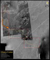
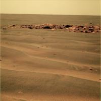
Here's our target "Block Island" in sight some 20m to the south.
We might get there in one driving sol and in position for IDD work in two more. 
|
|
|
|
|
Jul 27 2009, 04:38 PM
Post
#94
|
|
|
Member Group: Members Posts: 813 Joined: 8-February 04 From: Arabia Terra Member No.: 12 |
Two foreign forms on a sand ribbed plain
One low entropy The other high One moves The other still One itinerant The other resident One seeks The other found The seeker approaches |
|
|
|
|
Jul 27 2009, 04:46 PM
Post
#95
|
|||
|
The Poet Dude Group: Moderator Posts: 5551 Joined: 15-March 04 From: Kendal, Cumbria, UK Member No.: 60 |
Land - well, something interesting - ho..!
-------------------- |
||
|
|
|
||
|
Jul 27 2009, 08:36 PM
Post
#96
|
|
|
Member Group: Members Posts: 530 Joined: 21-March 06 From: Canada Member No.: 721 |
At this distance and angle, my mind is turning that object into a tiny boat being tossed about in the waves.
|
|
|
|
| Guest_Bobby_* |
Jul 27 2009, 08:56 PM
Post
#97
|
|
Guests |
What are those Crab Fishermen from The Deadliest Catch doing here on Mars?
Are they trying to catch cobbles of crabs here?
|
|
|
|
|
Jul 27 2009, 10:56 PM
Post
#98
|
|
|
Member Group: Members Posts: 233 Joined: 21-April 05 Member No.: 328 |
SFJCody, your poem is clever and elegant. It calls to mind this one:
Ozymandias Percy Bysshe Shelley I met a traveller from an antique land Who said: "Two vast and trunkless legs of stone Stand in the desert. Near them on the sand, Half sunk, a shattered visage lies, whose frown And wrinkled lip and sneer of cold command Tell that its sculptor well those passions read Which yet survive, stamped on these lifeless things, The hand that mocked them and the heart that fed. And on the pedestal these words appear: `My name is Ozymandias, King of Kings: Look on my works, ye mighty, and despair!' Nothing beside remains. Round the decay Of that colossal wreck, boundless and bare, The lone and level sands stretch far away". Hope I am not duplicating the work of someone else who has been inspired by the Meridiani landscape to post this poem . . . (and Stu -- haven't digested your longer poem yet -- but to whom does "The hand that mocked them and the heart that fed" refer to, ie, can you diagram that sentence?) And a related analog is, of course, the Rosetta Stone -- which is black -- and Block Island may prove to be a geological Rosetta Stone. |
|
|
|
| Guest_Enceladus75_* |
Jul 28 2009, 02:25 AM
Post
#99
|
|
Guests |
The latest traverse map looks puzzling.
Does this mean the Oppy team have now abandoned going West and will resume a route to the South?Or is there some other reason for the U turn? |
|
|
|
|
Jul 28 2009, 03:13 AM
Post
#100
|
|
|
Senior Member Group: Members Posts: 2173 Joined: 28-December 04 From: Florida, USA Member No.: 132 |
QUOTE (Enceladus75 @ Jul 27 2009, 09:25 PM) ...Or is there some other reason for the U turn? Go back to post 43 of this thread and read on from there. Yes, the reason is to go back for a look at the rock, Block Island. |
|
|
|
|

|
Lo-Fi Version | Time is now: 5th June 2024 - 04:54 AM |
|
RULES AND GUIDELINES Please read the Forum Rules and Guidelines before posting. IMAGE COPYRIGHT |
OPINIONS AND MODERATION Opinions expressed on UnmannedSpaceflight.com are those of the individual posters and do not necessarily reflect the opinions of UnmannedSpaceflight.com or The Planetary Society. The all-volunteer UnmannedSpaceflight.com moderation team is wholly independent of The Planetary Society. The Planetary Society has no influence over decisions made by the UnmannedSpaceflight.com moderators. |
SUPPORT THE FORUM Unmannedspaceflight.com is funded by the Planetary Society. Please consider supporting our work and many other projects by donating to the Society or becoming a member. |
|