Danuri: Korea's first lunar orbiter |

  |
Danuri: Korea's first lunar orbiter |
 Jul 26 2022, 09:19 PM Jul 26 2022, 09:19 PM
Post
#1
|
|
|
Solar System Cartographer  Group: Members Posts: 10191 Joined: 5-April 05 From: Canada Member No.: 227 |
https://www.kari.re.kr/eng/sub03_07_01.do
The link is to the Korean Space Agency's page on Danuri, the nation's first lunar orbiter. It will launch from the US in early August and orbit the Moon for a year. Of particular note is he inclusion of Shadowcam, a US payload modified from the LRO NAC instrument to image in polar shadows. I think I have seen it is 200 times more sensitive that NAC. We can hope for a lot of interesting images of polar areas. Work on a followup lander is in progress but may be slow. Phil -------------------- ... because the Solar System ain't gonna map itself.
Also to be found posting similar content on https://mastodon.social/@PhilStooke Maps for download (free PD: https://upload.wikimedia.org/wikipedia/comm...Cartography.pdf NOTE: everything created by me which I post on UMSF is considered to be in the public domain (NOT CC, public domain) |
 |
 
|
|
Jul 26 2022, 09:31 PM
Post
#2
|
|
|
Senior Member Group: Members Posts: 2517 Joined: 13-September 05 Member No.: 497 |
QUOTE (Phil Stooke @ Jul 26 2022, 01:19 PM)  I think I have seen it is 200 times more sensitive that NAC. Something like that; larger pixels (12 micron instead of 7), 32 TDI stages, and a higher QE sensor. It was a big pain to test compared to NAC because we had to use strong ND filters to image any normal scene. More info at http://shadowcam.sese.asu.edu/ -------------------- Disclaimer: This post is based on public information only. Any opinions are my own.
|
|
|
|
|
Jul 26 2022, 10:03 PM
Post
#3
|
|
|
Solar System Cartographer Group: Members Posts: 10191 Joined: 5-April 05 From: Canada Member No.: 227 |
Thanks, Mike.
Thinking about its operation... an area near a PSR but not in it will often be shadowed but sometimes illuminated. When it is illuminated NAC can see it perfectly well, but it will have very pronounced shadows which might complicate mission planning (e.g. a rover traverse into the PSR). There might be some occasions where an area like that could be imaged while in shadow, with the more diffuse reflected light softening the shadows enough to be helpful. I look forward to seeing the images. Phil -------------------- ... because the Solar System ain't gonna map itself.
Also to be found posting similar content on https://mastodon.social/@PhilStooke Maps for download (free PD: https://upload.wikimedia.org/wikipedia/comm...Cartography.pdf NOTE: everything created by me which I post on UMSF is considered to be in the public domain (NOT CC, public domain) |
|
|
|
|
Jul 26 2022, 10:10 PM
Post
#4
|
|
|
Senior Member Group: Members Posts: 2517 Joined: 13-September 05 Member No.: 497 |
QUOTE (Phil Stooke @ Jul 26 2022, 02:03 PM) I look forward to seeing the images. As do we! Keep in mind that while the launch is just a week away, it takes KPLO quite a while to get to the Moon; mapping won't start until sometime in December, I think. See https://directory.eoportal.org/web/eoportal...missions/k/kplo -------------------- Disclaimer: This post is based on public information only. Any opinions are my own.
|
|
|
|
|
Jul 26 2022, 11:54 PM
Post
#5
|
|
|
Senior Member Group: Members Posts: 2517 Joined: 13-September 05 Member No.: 497 |
BTW, in case this has occurred to anyone -- Shadowcam is not sensitive enough to see by Earthlight, but it's too sensitive to image anything illuminated by the Sun without saturating. So it can really only image shadowed regions slightly illuminated by surrounding lit topography. We tried to make it as insensitive to stray light as we could, but mixes of shadow and sunlight may cause problems -- we'll just have to see.
-------------------- Disclaimer: This post is based on public information only. Any opinions are my own.
|
|
|
|
|
Sep 1 2022, 07:42 AM
Post
#6
|
|
|
Solar System Cartographer Group: Members Posts: 10191 Joined: 5-April 05 From: Canada Member No.: 227 |
-------------------- ... because the Solar System ain't gonna map itself.
Also to be found posting similar content on https://mastodon.social/@PhilStooke Maps for download (free PD: https://upload.wikimedia.org/wikipedia/comm...Cartography.pdf NOTE: everything created by me which I post on UMSF is considered to be in the public domain (NOT CC, public domain) |
|
|
|
|
Sep 1 2022, 01:44 PM
Post
#7
|
||
|
Junior Member Group: Members Posts: 38 Joined: 7-October 20 Member No.: 8895 |
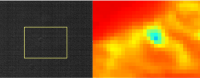
QUOTE (mcaplinger @ Jul 27 2022, 05:24 AM) BTW, in case this has occurred to anyone -- Shadowcam is not sensitive enough to see by Earthlight, but it's too sensitive to image anything illuminated by the Sun without saturating. So it can really only image shadowed regions slightly illuminated by surrounding lit topography. We tried to make it as insensitive to stray light as we could, but mixes of shadow and sunlight may cause problems -- we'll just have to see. I am waiting to see images from shadow cam as it gives us more insight into areas like these from NAC near the Shackleton (This is near the landing area of Artemis near the connecting ridge). Max temperature in Summer is around 120K so most probably it might be ice!
Attached thumbnail(s)
|
|
|
|
|
|
|
Oct 2 2022, 11:22 PM
Post
#8
|
|
|
Solar System Cartographer Group: Members Posts: 10191 Joined: 5-April 05 From: Canada Member No.: 227 |
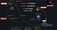
Round about now Danuri is at its most distant from Earth, 1.55 million km, out near Sun-Earth L1. It will now begin to fall in towards Earth and encounter the Moon in December.
Phil -------------------- ... because the Solar System ain't gonna map itself.
Also to be found posting similar content on https://mastodon.social/@PhilStooke Maps for download (free PD: https://upload.wikimedia.org/wikipedia/comm...Cartography.pdf NOTE: everything created by me which I post on UMSF is considered to be in the public domain (NOT CC, public domain) |
|
|
|
|
Nov 9 2022, 08:16 PM
Post
#9
|
||
|
Solar System Cartographer Group: Members Posts: 10191 Joined: 5-April 05 From: Canada Member No.: 227 |
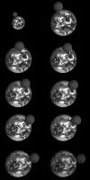
A transit (passing over Korea) on 24 September. These are frames from a video on the mission website.
Phil
-------------------- ... because the Solar System ain't gonna map itself.
Also to be found posting similar content on https://mastodon.social/@PhilStooke Maps for download (free PD: https://upload.wikimedia.org/wikipedia/comm...Cartography.pdf NOTE: everything created by me which I post on UMSF is considered to be in the public domain (NOT CC, public domain) |
|
|
|
|
|
|
Nov 10 2022, 12:02 AM
Post
#10
|
|
 Member Group: Members Posts: 701 Joined: 3-December 04 From: Boulder, Colorado, USA Member No.: 117 |
Sweet! Do you have a link to the original source?
John |
|
|
|
|
Nov 10 2022, 06:00 AM
Post
#11
|
|
|
Solar System Cartographer Group: Members Posts: 10191 Joined: 5-April 05 From: Canada Member No.: 227 |
I thought the link I put in the first post in this thread was to that page but I see now that it is not.
Here is the Danuri website's multimedia page: https://www.kari.re.kr/kplo/multimedia And this is that specific item: https://www.kari.re.kr/kplo/danuri/multi/mu...&searchWrd= Phil -------------------- ... because the Solar System ain't gonna map itself.
Also to be found posting similar content on https://mastodon.social/@PhilStooke Maps for download (free PD: https://upload.wikimedia.org/wikipedia/comm...Cartography.pdf NOTE: everything created by me which I post on UMSF is considered to be in the public domain (NOT CC, public domain) |
|
|
|
|
Dec 5 2022, 08:18 AM
Post
#12
|
||
|
Solar System Cartographer Group: Members Posts: 10191 Joined: 5-April 05 From: Canada Member No.: 227 |
Danuri is approaching the Moon:
It will enter lunar orbit on the 17th. Phil -------------------- ... because the Solar System ain't gonna map itself.
Also to be found posting similar content on https://mastodon.social/@PhilStooke Maps for download (free PD: https://upload.wikimedia.org/wikipedia/comm...Cartography.pdf NOTE: everything created by me which I post on UMSF is considered to be in the public domain (NOT CC, public domain) |
|
|
|
|
|
|
Dec 27 2022, 08:16 AM
Post
#13
|
|
|
Solar System Cartographer Group: Members Posts: 10191 Joined: 5-April 05 From: Canada Member No.: 227 |
Safely in orbit and getting close to its 100 km science orbit. Meanwhile, see this excellent FISO talk by Ben Bussey (now at Intuitive Machines, previously NASA).
https://fiso.spiritastro.net/telecon/Bussey_12-21-22/ Phil -------------------- ... because the Solar System ain't gonna map itself.
Also to be found posting similar content on https://mastodon.social/@PhilStooke Maps for download (free PD: https://upload.wikimedia.org/wikipedia/comm...Cartography.pdf NOTE: everything created by me which I post on UMSF is considered to be in the public domain (NOT CC, public domain) |
|
|
|
|
Jan 3 2023, 02:43 PM
Post
#14
|
|
 Senior Member Group: Members Posts: 1443 Joined: 26-July 08 Member No.: 4270 |
-------------------- -- Hungry4info (Sirius_Alpha)
|
|
|
|
|
Jan 3 2023, 03:10 PM
Post
#15
|
|
|
Senior Member Group: Members Posts: 2090 Joined: 13-February 10 From: Ontario Member No.: 5221 |
Wow! Like the old LROC Earthrise from 2014, just b/w!
|
|
|
|
|
Jan 3 2023, 08:31 PM
Post
#16
|
|
|
Solar System Cartographer Group: Members Posts: 10191 Joined: 5-April 05 From: Canada Member No.: 227 |
-------------------- ... because the Solar System ain't gonna map itself.
Also to be found posting similar content on https://mastodon.social/@PhilStooke Maps for download (free PD: https://upload.wikimedia.org/wikipedia/comm...Cartography.pdf NOTE: everything created by me which I post on UMSF is considered to be in the public domain (NOT CC, public domain) |
|
|
|
|
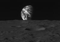
Jan 8 2023, 10:45 AM
Post
#17
|
|
 Member Group: Members Posts: 815 Joined: 3-June 04 From: Brittany, France Member No.: 79 |
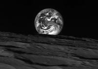
A picture taken on 28 November 2022 at a distance such as the Earth and the Moon had the same apparent size for Danuri's camera.
Contrast increased on the Moon's surface since it appears far much darker than the Earth on the original image. 
-------------------- |
|
|
|
|
Jan 10 2023, 12:09 AM
Post
#18
|
|
|
Senior Member Group: Members Posts: 2517 Joined: 13-September 05 Member No.: 497 |
http://shadowcam.sese.asu.edu/images/1284
"The first ShadowCam image from orbit reveals the permanently shadowed wall and floor of Shackleton crater in never before seen detail." -------------------- Disclaimer: This post is based on public information only. Any opinions are my own.
|
|
|
|
|
Jan 10 2023, 01:38 AM
Post
#19
|
|
|
Solar System Cartographer Group: Members Posts: 10191 Joined: 5-April 05 From: Canada Member No.: 227 |
Very impressive, Mike. Well done!
-------------------- ... because the Solar System ain't gonna map itself.
Also to be found posting similar content on https://mastodon.social/@PhilStooke Maps for download (free PD: https://upload.wikimedia.org/wikipedia/comm...Cartography.pdf NOTE: everything created by me which I post on UMSF is considered to be in the public domain (NOT CC, public domain) |
|
|
|
|
Feb 10 2023, 04:38 AM
Post
#20
|
|
|
Solar System Cartographer Group: Members Posts: 10191 Joined: 5-April 05 From: Canada Member No.: 227 |
More from ShadowCam. This is part of a small crater inside a much larger one near the north pole. Check out the full mosaic at the bottom of the page, zoomable or downloadable.
Phil https://www.shadowcam.asu.edu/images/1288 -------------------- ... because the Solar System ain't gonna map itself.
Also to be found posting similar content on https://mastodon.social/@PhilStooke Maps for download (free PD: https://upload.wikimedia.org/wikipedia/comm...Cartography.pdf NOTE: everything created by me which I post on UMSF is considered to be in the public domain (NOT CC, public domain) |
|
|
|
|
Feb 15 2023, 07:49 AM
Post
#21
|
|
|
Solar System Cartographer Group: Members Posts: 10191 Joined: 5-April 05 From: Canada Member No.: 227 |
-------------------- ... because the Solar System ain't gonna map itself.
Also to be found posting similar content on https://mastodon.social/@PhilStooke Maps for download (free PD: https://upload.wikimedia.org/wikipedia/comm...Cartography.pdf NOTE: everything created by me which I post on UMSF is considered to be in the public domain (NOT CC, public domain) |
|
|
|
|
Mar 15 2023, 06:59 AM
Post
#22
|
|
|
Solar System Cartographer Group: Members Posts: 10191 Joined: 5-April 05 From: Canada Member No.: 227 |
New image from ShadowCam - Marvin crater, which is adjacent to de Gerlache at one end of the 'Connecting Ridge' near the south pole.
https://www.shadowcam.asu.edu/images/1293 Phil -------------------- ... because the Solar System ain't gonna map itself.
Also to be found posting similar content on https://mastodon.social/@PhilStooke Maps for download (free PD: https://upload.wikimedia.org/wikipedia/comm...Cartography.pdf NOTE: everything created by me which I post on UMSF is considered to be in the public domain (NOT CC, public domain) |
|
|
|
|
Mar 15 2023, 01:52 PM
Post
#23
|
|
|
Member Group: Members Posts: 701 Joined: 3-December 04 From: Boulder, Colorado, USA Member No.: 117 |
The quality of these images is remarkable. It's interesting to see the lighting coming from different directions in different parts of the image.
John |
|
|
|
|
Mar 31 2023, 08:36 PM
Post
#24
|
|
|
Solar System Cartographer Group: Members Posts: 10191 Joined: 5-April 05 From: Canada Member No.: 227 |
Another great image from ShadowCam.
https://www.shadowcam.asu.edu/images/1297 This is the central peak of Aristarchus seen by Earthlight. I hadn't thought much about Earthlight imaging before but now I am interested in seeing what some Apollo and other sites would look like. Phil -------------------- ... because the Solar System ain't gonna map itself.
Also to be found posting similar content on https://mastodon.social/@PhilStooke Maps for download (free PD: https://upload.wikimedia.org/wikipedia/comm...Cartography.pdf NOTE: everything created by me which I post on UMSF is considered to be in the public domain (NOT CC, public domain) |
|
|
|
|
Mar 31 2023, 09:12 PM
Post
#25
|
|
|
Senior Member Group: Members Posts: 2517 Joined: 13-September 05 Member No.: 497 |
QUOTE (Phil Stooke @ Mar 31 2023, 12:36 PM) I hadn't thought much about Earthlight imaging before... When we were developing Shadowcam, we tried to come up with ways of having the TDI be selectable so that we could still image on the dayside, but this was just too complex given the constraints of the electronics. So we always asked about Earthlight images, but the SNRs are much poorer than the dimmest permanently-shadowed regions (which you can see in the graininess of the images.) Still, it's better than nothing and a good indication that the system doesn't do too badly even at very low signal levels. -------------------- Disclaimer: This post is based on public information only. Any opinions are my own.
|
|
|
|
|
Apr 1 2023, 04:58 AM
Post
#26
|
|
|
Member Group: Members Posts: 701 Joined: 3-December 04 From: Boulder, Colorado, USA Member No.: 117 |
Sweet! I remember seeing Apollo images of Orientale from lunar orbit in Earthlight, much lower resolution and grainier than this one. Probably in one of the Apollo Preliminary Science Reports (Phil would know).
John |
|
|
|
|
Apr 1 2023, 07:03 PM
Post
#27
|
|
|
Member Group: Members Posts: 149 Joined: 18-June 08 Member No.: 4216 |
Not an expert, but I recall looking at prints of Lunar Orbiter images that were of similar resolution to these impressive shots.
|
|
|
|
|
Apr 1 2023, 09:08 PM
Post
#28
|
|
|
Solar System Cartographer Group: Members Posts: 10191 Joined: 5-April 05 From: Canada Member No.: 227 |
John's faith in me is touching.
According to my records, Apollo 13 was intended to image the area around Orientale by Earthshine at the end of its orbital phase (but didn't for obvious reasons). Some experimental Earthshine images of Aristarchus were taken by Apollo 15, followed by sunlit images of the same area later. Apollo 16 took a few images across Riccioli crater late in the mission. Finally, Apollo 17 took quite a few frames from the Luna 9 area out across Orientale. In addition to these images, Earthshine images have also been taken by star-tracker cameras on Clementine and LADEE. I think Lunar Flashlight might have done the same (or perhaps one of the other recent lunar cubesats, RIP) if its mission had gone as intended. Phil -------------------- ... because the Solar System ain't gonna map itself.
Also to be found posting similar content on https://mastodon.social/@PhilStooke Maps for download (free PD: https://upload.wikimedia.org/wikipedia/comm...Cartography.pdf NOTE: everything created by me which I post on UMSF is considered to be in the public domain (NOT CC, public domain) |
|
|
|
|
Apr 15 2023, 06:00 AM
Post
#29
|
|
|
Solar System Cartographer Group: Members Posts: 10191 Joined: 5-April 05 From: Canada Member No.: 227 |
Some nice new images on the Danuri website. A view of the central peak of Tsiolovskiy is particularly dramatic.
https://www.kari.re.kr/kplo/multimedia Phil -------------------- ... because the Solar System ain't gonna map itself.
Also to be found posting similar content on https://mastodon.social/@PhilStooke Maps for download (free PD: https://upload.wikimedia.org/wikipedia/comm...Cartography.pdf NOTE: everything created by me which I post on UMSF is considered to be in the public domain (NOT CC, public domain) |
|
|
|
|
May 3 2024, 05:57 PM
Post
#30
|
|
|
Junior Member Group: Members Posts: 47 Joined: 23-July 11 Member No.: 6083 |
Danuri's instrument images are now available for download, though it's a tricky business. Here's a link to the files released so far:
https://www.kari.re.kr/kpds/published/KPLO/...O/PublicRelease As yet there's no map based search, which is a shame as the xml files accompanying the images don't seem to have lat/long data included (at least for LUTI). There is a search facility, but it's difficult and slow to navigate, eg: https://www.kari.re.kr/kpds/search_view/lev...ct?keyword=LUTI Shadowcam data can be searched for here: https://data.ser.asu.edu/lunaserv.html Edited to add: They did release views of Apollo 11 and 17's landing sites here: https://twitter.com/kari2030/status/1706532004945412205 The Shadowcam has also coverd Apollo 14, 15 and part of Taurus-Littrow under Earthshine conditions. |
|
|
|
|

|
Lo-Fi Version | Time is now: 9th June 2024 - 07:34 AM |
|
RULES AND GUIDELINES Please read the Forum Rules and Guidelines before posting. IMAGE COPYRIGHT |
OPINIONS AND MODERATION Opinions expressed on UnmannedSpaceflight.com are those of the individual posters and do not necessarily reflect the opinions of UnmannedSpaceflight.com or The Planetary Society. The all-volunteer UnmannedSpaceflight.com moderation team is wholly independent of The Planetary Society. The Planetary Society has no influence over decisions made by the UnmannedSpaceflight.com moderators. |
SUPPORT THE FORUM Unmannedspaceflight.com is funded by the Planetary Society. Please consider supporting our work and many other projects by donating to the Society or becoming a member. |
|