Pluto System Cartography, places and names |

  |
Pluto System Cartography, places and names |
 Jul 28 2015, 08:17 PM Jul 28 2015, 08:17 PM
Post
#1
|
|
 Member  Group: Members Posts: 423 Joined: 13-November 14 From: Norway Member No.: 7310 |
BuzzFeed have gotten their hands on how the NH team plans to name features on both Pluto and Charon: http://www.buzzfeed.com/alexkasprak/the-vader-crater
The names give some clues for how the science team is interpreting things: you find things named fossa, vallis, cavus, rupes, dorsa and linea - all on Pluto. EDIT: The maps on the mission website: Pluto Sputnik plain and surroundings Charon This post has been edited by Habukaz: Dec 20 2015, 09:11 PM -------------------- |
 |
 
|
|
Jul 28 2015, 08:43 PM
Post
#2
|
|
|
Senior Member Group: Members Posts: 1583 Joined: 14-October 05 From: Vermont Member No.: 530 |
Cousteau Rupes! It's an escarpment!
Charon has Star Trek and Star Wars names... |
|
|
|
|
Jul 29 2015, 12:18 AM
Post
#3
|
|
 Member Group: Members Posts: 714 Joined: 3-January 08 Member No.: 3995 |
QUOTE (Habukaz @ Jul 28 2015, 03:17 PM)  BuzzFeed has gotten their hands on how the NH team plans to name features on both Pluto and Charon: http://www.buzzfeed.com/alexkasprak/the-vader-crater It's interesting that the Baré and al-Idrisi Montes have been named, even though those areas are vague in the images released so far. Hopefully, we'll get a peak soon (no pun intended).... 
|
|
|
|
|
Jul 29 2015, 01:31 AM
Post
#4
|
|
 IMG to PNG GOD Group: Moderator Posts: 2251 Joined: 19-February 04 From: Near fire and ice Member No.: 38 |
QUOTE (Antdoghalo @ Jul 28 2015, 09:59 PM) Unfortunately I am unable to view images as large as 16K. Are you working on a map of Charon too? The animation sounds like it will be awesome to see when it's done. I did a map of Charon that I posted earlier in the thread, i.e. here. There isn't a lot of new Charon images since I posted it but nevertheless I may update it later this week. |
|
|
|
|
Jul 29 2015, 03:10 AM
Post
#5
|
|
 SewingMachine Group: Members Posts: 316 Joined: 27-September 05 From: Seattle Member No.: 510 |
I've uploaded a version of the Johns Hopkins/SWRI map labeled with feature names at: https://www.flickr.com/photos/135024395@N07...eposted-public/
Edit: Added Charon based on your map, Bjorn: https://www.flickr.com/photos/135024395@N07...eposted-public/ Interesting how they've set up the various schema. Charon's Chasmata are named after fictional vehicles, craters after characters, ect. I can imagine people developing an interest in planetary cartography thanks to what they're doing here. -------------------- ...if you don't like my melody, i'll sing it in a major key, i'll sing it very happily. heavens! everybody's all aboard? let's take it back to that minor chord...
Exploitcorporations on Flickr (in progress) : https://www.flickr.com/photos/135024395@N07/ |
|
|
|
|
Jul 29 2015, 11:42 AM
Post
#6
|
|
|
Senior Member Group: Members Posts: 2998 Joined: 30-October 04 Member No.: 105 |
They have developed a unique naming strategy. At their public naming campaign website, http://www.ourpluto.org/home, there is the full (and wacky) list of names submitted to the IAU for their perusal.
Initial Proposal to the IAU, July 7, 2015 http://www.ourpluto.org/pluto The Naming of Names at a site is a long and honorable geological tradition. During the delay in getting out preliminary names for the Rosetta mission I managed to go through the Rocky and Bulwinkle pantheon for my informal names... --Bill -------------------- |
|
|
|
|
Jul 29 2015, 03:20 PM
Post
#7
|
|
|
Member Group: Members Posts: 112 Joined: 31-January 15 From: Houston, TX USA Member No.: 7390 |
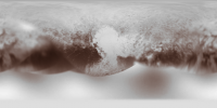
QUOTE (neo56 @ Jul 28 2015, 02:47 PM) Here is my take on the LORRI mosaic, rotated and very slightly sharpened. I colorized it with the 2x2 color picture of Pluto. Since this color low resolution picture and the B&W LORRI mosaic didn't overlap correctly with simple rotation, translation or shearing, I cut the color picture into 50 segments. Then I warped each segment to match the LORRI mosaic. It took me hours of work on Gimp but the result is worth it Every time I look at a nicely rendered image of Sputnik Planum, I really want to call it Sputnik Lacus. That sure looks like a frozen shoreline in the northwest quadrant, with the frozen nitrogen flows. Andy |
|
|
|
|
Jul 29 2015, 05:23 PM
Post
#8
|
|
 Senior Member Group: Members Posts: 1639 Joined: 5-March 05 From: Boulder, CO Member No.: 184 |
QUOTE (Exploitcorporations @ Jul 29 2015, 03:10 AM) Interesting how they've set up the various schema. Charon's Chasmata are named after fictional vehicles, craters after characters, ect. I can imagine people developing an interest in planetary cartography thanks to what they're doing here. Nicely done feature names and such on the maps. I wonder if the eastern part of Serenity Chasma on Charon is more of an escarpment, or if that's just a trick of the lighting and resolution? -------------------- Steve [ my home page and planetary maps page ]
|
|
|
|
|
Jul 30 2015, 08:59 PM
Post
#9
|
|
|
Senior Member Group: Members Posts: 1639 Joined: 5-March 05 From: Boulder, CO Member No.: 184 |
-------------------- Steve [ my home page and planetary maps page ]
|
|
|
|
|
Jul 31 2015, 02:06 PM
Post
#10
|
|
|
Junior Member Group: Members Posts: 64 Joined: 17-December 12 From: Portugal Member No.: 6792 |
QUOTE (scalbers @ Jul 30 2015, 09:59 PM) Just a little cleanup for my Pluto map: Great work as always! Any chance of filling the bottom of the map with Hubble / occultation data ? -------------------- www.astrosurf.com/nunes
|
|
|
|
|
Jul 31 2015, 05:09 PM
Post
#11
|
|
|
Merciless Robot Group: Admin Posts: 8784 Joined: 8-December 05 From: Los Angeles Member No.: 602 |
MOD NOTE: One post (& two responses to same) hidden that was less about cartography than it was about IAU complaints & snark re the NH team. See rules 1.9 and 2.6.
-------------------- A few will take this knowledge and use this power of a dream realized as a force for change, an impetus for further discovery to make less ancient dreams real.
|
|
|
|
|
Aug 2 2015, 02:39 AM
Post
#12
|
|
|
SewingMachine Group: Members Posts: 316 Joined: 27-September 05 From: Seattle Member No.: 510 |
An exhaustive treatment of the proposed names from io9's Mika McKinnon, complete with biographies and illustrations: http://space.io9.com/were-actively-creatin...iver-1721448557
-------------------- ...if you don't like my melody, i'll sing it in a major key, i'll sing it very happily. heavens! everybody's all aboard? let's take it back to that minor chord...
Exploitcorporations on Flickr (in progress) : https://www.flickr.com/photos/135024395@N07/ |
|
|
|
|
Aug 4 2015, 06:45 PM
Post
#13
|
||
|
Senior Member Group: Members Posts: 1639 Joined: 5-March 05 From: Boulder, CO Member No.: 184 |
QUOTE (4throck @ Jul 31 2015, 02:06 PM) Any chance of filling the bottom of the map with Hubble / occultation data ? Good idea 4throck. Here is a preliminary version at 2K resolution. Full res is at the website in my signature.
EDIT: Fixed longitude (hopefully) of FOC image at 2216UTC -------------------- Steve [ my home page and planetary maps page ]
|
|
|
|
|
|
|
Aug 6 2015, 06:01 PM
Post
#14
|
|
|
Member Group: Members Posts: 509 Joined: 2-July 05 From: Calgary, Alberta Member No.: 426 |
Nice to see that they have named large features after Tombaugh and Lowell.
I hope they can find someplace to fit Vesto Slipher and Carl Lampland. |
|
|
|
|
Aug 6 2015, 08:32 PM
Post
#15
|
|
 Member Group: Members Posts: 227 Joined: 13-October 09 From: Olympus Mons Member No.: 4972 |
That's awesome, no more of that blank space! With it one can guess that Balrog Macula and Cthulhu Regio to a lesser extent may extend well into the southern hemisphere. Perhaps like Paul Schenk's map of Triton, any Charonshine images could be used to fill further data into this region to confirm it.
-------------------- "Thats no moon... IT'S A TRAP!"
|
|
|
|
|
Aug 10 2015, 07:35 PM
Post
#16
|
|||
 Junior Member Group: Members Posts: 82 Joined: 13-July 15 Member No.: 7579 |
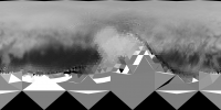
With the use of metadata of LORRI frames I clarify trajectory of New Horizons (error is about 0.000002 on distancies to Pluto at snapshots momens). After that it made possible to simulate all frames with subpixel accuracy. As a bonus Pluto radius was determined: R=240.89 km * u, where 'u' is LORRI pixel size in microradians.
If we assume that the under-Charon avarage point has longitude 0°, then the map of Pluto (for example http://www.unmannedspaceflight.com/index.p...t&id=37374) is offset by 1.6 ° to the east. So I had to make such correction to map, that the image consistent with LORRI frames. Nevertheless, clear to see that there are still quite a strong distortion in the map. Another file, which I posted earlier in http://www.unmannedspaceflight.com/index.p...8071&st=30:
There is a general shift of the East, which I removed, but there are still some parts of the motion relative to each other. To generate frames I used this map:
Map was taken from http://www.unmannedspaceflight.com/index.p...st&id=37232 and enlarged to the right (eastern) side and manually filled in the southern region based on the map obtained by the Hubble Space Telescope observations. |
||
|
|
|
||
|
Aug 10 2015, 08:46 PM
Post
#17
|
||
|
Junior Member Group: Members Posts: 82 Joined: 13-July 15 Member No.: 7579 |
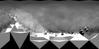
Rebuilt pictures with the map
http://pluto.jhuapl.edu/Multimedia/Science..._PS723_HR-g.jpg and obtained with offset = 0
Maybe tomorrow I will do a map based on a backward projecting of the LORRI images ... |
|
|
|
|
|
|
Aug 10 2015, 09:16 PM
Post
#18
|
|
|
Senior Member Group: Members Posts: 1639 Joined: 5-March 05 From: Boulder, CO Member No.: 184 |
Interesting in that I had also noticed a North-South in my map compared with the official one near Tombaugh Regio. If we have the lat/lon subpoints readily available for the images (and if they are accurate) we can perhaps check and refine the maps better.
-------------------- Steve [ my home page and planetary maps page ]
|
|
|
|
|
Aug 11 2015, 07:58 AM
Post
#19
|
||||
|
Junior Member Group: Members Posts: 82 Joined: 13-July 15 Member No.: 7579 |
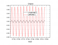
QUOTE (Bjorn Jonsson @ Aug 11 2015, 12:25 AM) Regarding NH's trajectory, if I remember correctly the flyby didn't occur at exactly the planned time (off by some seconds but well within the required accuracy) and this makes it more tricky to use the metadata to accurately determine the viewing geometry (especially in the hi-res images) until an updated trajectory (SPICE kernels) becomes avvailable. At first I tried to use the data from http://ssd.jpl.nasa.gov/horizons.cgi#top 2457218.000000000 = A.D. 2015-Jul-14 12:00:00.0000 (CT) NH: r[km] 1.197739374505814E+09 -4.443897760753548E+09 -1.747680731829689E+09 v[km/s] 5.534336802447741E+00 -1.252001712778965E+01 -4.846832563458260E+00 Pluto: 1.197726655664916E+09 -4.443893298780707E+09 -1.747673432906277E+09 5.379986303470789E+00 8.159673817708096E-01 -1.389030301906091E+00 Charon: 1.197712275411875E+09 -4.443906278626040E+09 -1.747670469452485E+09 5.388459229072444E+00 8.566266433864180E-01 -1.169827709122328E+00 but I found that the position of NH was displaced approximately 120 seconds, so I used the least squares method (with using distances to Pluto, Charon, Nix and Hydra up to 2,000,000 km) to made a correction of 3D position (about 1,665 kilometers) and velocity vector (about 11.6 m/s) so that the simulated distances become coincide to metadata with an error of about 0.1 km. r0_NH {1.1977391023383e9, -4.44389934311302e9, -1.74768117382772e9} v0_NH {5.53196172582933, -12.51701129448342, -4.85774060000822} For the calculation of rotation of Pluto and Charon, I used data from http://link.springer.com/article/10.1007%2Fs10569-010-9320-4 North pole: alpha0=132°.993, delta0=-6°.163, turn: W=237°.305+56°.3625225d
but turn does not coincide with data from http://ssd.jpl.nasa.gov/horizons.cgi#top so I use turn W=304°.155524+56°.3625225d and changed GM=873.22336378 km^3/s^2 for Pluto (instead 872.4 km^3/s^2). As a result I got the following location of Charon relative Pluto:
So if we take the Charon position as the origin point on Pluto, the ambiguity is not more than 0.1 degrees in latitude and 0.01 degrees in longitude. While for the purposes of mapping accuracy it is sufficient. QUOTE (scalbers @ Aug 11 2015, 02:16 AM) Interesting in that I had also noticed a North-South in my map compared with the official one near Tombaugh Regio. If we have the lat/lon subpoints readily available for the images (and if they are accurate) we can perhaps check and refine the maps better. The main ambiguity is in position of Pluto center in frames. The given in metadata values are too bad, so I adjust it manually. Only selfconsistent automatic map generation procedure can give accurate parameters... Now I generate grids for all available LORRI frames. To better quality size is doubled to 2048x2048. Steps are 1,5,10 and 30 degrees. For example:
You can get grids in folder "Grids" from ftp://gionov:NG@46.45.15.20/_Data/_LORRI/ The source images placed in "Source", simulated images in "Simulate". |
|||
|
|
|
|||
|
Aug 26 2015, 10:02 AM
Post
#20
|
|
|
Member Group: Members Posts: 423 Joined: 13-November 14 From: Norway Member No.: 7310 |
Bah, apparently there will be disagreement over the naming.
An IAU press release from March already says something similar: QUOTE Please note, however, that votes for other themes will not be taken into account, incl. the following, since these themes have already been used on Mercury, Venus and Mars:
-------------------- |
|
|
|
|
Aug 26 2015, 01:25 PM
Post
#21
|
|
|
Senior Member Group: Members Posts: 2998 Joined: 30-October 04 Member No.: 105 |
IAU should have had at least a provisional, if not formal, series of names already in place before the Pluto encounter. The time of the flyby has been known for ten years and many albedo features on Pluto have been known for longer. The surface of Charon was a general unknown, but give what we know of similar bodies there were to be Regios Chasmas and Craters to be named.
Although IAU did have the "exclusion disclaimer" in their Spring 2015 (!!) naming campaign announcement, this was a "shot across the bow" in response to prior discussions with the NH Team. Informal names are good. I've got many 67P/C-G features named after the "Rocky and Bullwinkle" pantheon. Let me tell you about Fenwick Boulder on Frostbite Falls Planum... --Bill -------------------- |
|
|
|
|
Aug 26 2015, 02:57 PM
Post
#22
|
|
 Senior Member Group: Members Posts: 2530 Joined: 20-April 05 Member No.: 321 |
Names are always a sign of the times, and Pluto's naming represents a turn towards pop culture that would have been unthinkable when names were being applied to the front/back sides of the Moon, or Mars, Mercury, or the Galileans.
Decades and centuries hence, the names on Pluto will identify who and when the namers were just as the names on the backside of the Moon are an eternal nod to Mother Russia. |
|
|
|
|
Aug 26 2015, 09:35 PM
Post
#23
|
|
|
Junior Member Group: Members Posts: 71 Joined: 3-February 11 Member No.: 5800 |
It is Sputnik Planum AFAIC. The IAU can't change THAT.
|
|
|
|
|
Aug 26 2015, 11:50 PM
Post
#24
|
|
|
Solar System Cartographer Group: Members Posts: 10166 Joined: 5-April 05 From: Canada Member No.: 227 |
Don't worry too much about names. Anyone can name anything, anyway they like. The only question is whether other people will use those names.
For instance, near my house in London, Ontario, down by the river, there's a big boulder which we (my family) call Mermaid Rock. Nobody else uses the name. That's fine. I could make a map of Europe with my own idiosyncratic names for all the countries and major cities. Nobody else would use them. National Lampoon once published a world map full of humorous names. Anyone can name anything. The IAU has an important role in deciding official names, but they have no say over unofficial names. The only question is whether anyone will use the names. So most planetary scientists will stick with official names, but you still see references even in refereed papers to Inca City on Mars, or the Schneckenberg on the Moon. And of course all those names of rocks etc. at the Mars landing sites. As for Pluto, maybe there will be two maps, with official names and unofficial names. That's OK, we can cope with it. Chances are most people will use official names and a few will use the unofficial names that become most well-known. Like Mount Sharp on Mars, not official but we all know what it means. Phil -------------------- ... because the Solar System ain't gonna map itself.
Also to be found posting similar content on https://mastodon.social/@PhilStooke Maps for download (free PD: https://upload.wikimedia.org/wikipedia/comm...Cartography.pdf NOTE: everything created by me which I post on UMSF is considered to be in the public domain (NOT CC, public domain) |
|
|
|
|
Aug 27 2015, 12:43 AM
Post
#25
|
|
 Member Group: Members Posts: 244 Joined: 2-March 15 Member No.: 7408 |
I don't agree that names have the capacity to be official. I wouldn't even accept as valid a statement that a person or group considers their names for extraterrestrial features to be official unless they also claimed to have ownership of the features in question. Otherwise, they either don't understand the meaning of the word "official" and that they mean to say they like those names and feel others should adopt them, or are simply speaking a different (though very similar) language than I speak.
I've noticed, throughout my lifetime, that people like to throw the word "official" around, usually affixing it to something to superficially strengthen an argument or to try to build some precedent for future trust. I don't recall reading about the Prime Minister of Pluto or the Plutonian Senate delegating the task of naming features on Pluto to the IAU so they'd have more time for skiing at Norgay Montes. I recognize that many people (and other entities) adopt IAU naming for extraterrestrial features, and that's perfectly fine; it can be very helpful to have a go-to source for names that you feel confident many other people with whom you communicate will have similarly adopted. That doesn't make those names official, unless you take a more relaxed meaning of that word, allowing for there to be multiple, different, official names for a thing, provided by multiple, different sources. As far as I am aware, however, the IAU has not claimed ownership of Pluto or any geographical subset of it, nor have they been designated the official namers by anyone who does make such a claim of ownership, so the names they assign are not even considered by them to be official (though they may say that; as I said earlier, they'd simply be misspeaking in that case, actually meaning that they like those names and feel others should adopt them). As Phil said, people will call things whatever they want, and fortunately, usefully, a lot of people will gravitate toward the same names, making communication about those features simple and convenient. I think where Phil and I probably disagree is on the validity of affixing the word "official" to anyone's provided names. Edit (added 2015-08-31): Note: I do not mean to sound critical of the IAU. As I said, it is very helpful for people to be able to refer to features on other worlds by names that others will understand, and the IAU is (I believe) the most popular source for such names and assigns them with a consistent style/convention. My above comments are merely me engaging in pedantry with regard to how people misuse the word "official". Personally, I'll be using whatever names I'm used to (currently, those the team has come up with) until a time comes when most people are using different names, at which time, on a name-by-name basis, I'll transition to using whatever those are, irrespective of who came up with them, so that I can be understood. |
|
|
|
|
Aug 27 2015, 03:55 AM
Post
#26
|
|
|
Senior Member Group: Members Posts: 2517 Joined: 13-September 05 Member No.: 497 |
The topic of naming might be considered as an addition to rule 1.9. [MOD- Noted.]
http://planetarynames.wr.usgs.gov/Page/Introduction and http://planetarynames.wr.usgs.gov/Page/Rules are the most succinct statements of current IAU policy. And yes, IAU uses the word "official" a lot; e.g., from http://planetarynames.wr.usgs.gov/Page/FAQ QUOTE The International Astronomical Union (IAU) Working Group for Planetary System Nomenclature provides a unique system of official names for planetary surface features, natural satellites, dwarf planets, and planetary rings for the benefit of the international science community, educators, and the general public. A single system of official names is critical for effective scientific communication.
-------------------- Disclaimer: This post is based on public information only. Any opinions are my own.
|
|
|
|
|
Aug 27 2015, 04:23 AM
Post
#27
|
|
|
Merciless Robot Group: Admin Posts: 8784 Joined: 8-December 05 From: Los Angeles Member No.: 602 |
MOD NOTE: Recall that Aeolis Mons--as it is officially named by the IAU--at the MSL landing site is unofficially known as Mt. Sharp. Same principle applies here. Feel free to call Plutonian features anything you'd like, and it's extremely likely that some of the informal names will persist indefinitely...but the IAU names will be official.
Debates and/or complaints about the validity of IAU names will not be permitted. Many planetary science pros are in fact IAU members (see rule 2.6) and rants in general are not allowed under rule 2.4. As mcaplinger previously noted, rule 1.9 covers contentious topics that really have no bearing on science; although IAU naming processes and conventions are not specifically cited in this rule, note that a previous IAU action is. That may be indicative. -------------------- A few will take this knowledge and use this power of a dream realized as a force for change, an impetus for further discovery to make less ancient dreams real.
|
|
|
|
|
Aug 27 2015, 06:21 AM
Post
#28
|
|
|
Senior Member Group: Members Posts: 2086 Joined: 13-February 10 From: Ontario Member No.: 5221 |
Nothing wrong with multiple names as long as we stay consistent. Anyone remember Ultreya Abyss aka El Dorado at Gusev?
|
|
|
|
|
Aug 27 2015, 09:02 AM
Post
#29
|
|
|
Senior Member Group: Members Posts: 2998 Joined: 30-October 04 Member No.: 105 |
"Ultreya" was hardly widespread and was an annoying local quirk. And it was more a rant proposing an oddball theory of the nature of the feature than simply an alternate name.
 --Bill -------------------- |
|
|
|
|
Aug 27 2015, 10:09 AM
Post
#30
|
|
|
Member Group: Members Posts: 423 Joined: 13-November 14 From: Norway Member No.: 7310 |
The problem with more than one set of names is that it effects communication negatively - the reader will need more familiarity with the subject in order to know which names refer to the same thing.
(I'll make a biased exception for names like the heart, because they are highly intuitive  ) )
-------------------- |
|
|
|
|
Aug 27 2015, 11:01 AM
Post
#31
|
|
|
Senior Member Group: Members Posts: 2530 Joined: 20-April 05 Member No.: 321 |
A point of comparison:
The various Mars rovers had mission planning that included the use of unofficial names for, e.g., individual rocks, so that science teams could coordinate effectively. This was absolutely necessary for daily rover operations. The Pluto observations, on the other hand, were all performed according to a pre-programmed script, so there was little to no operational need for unofficial names. It may be useful to have unofficial names in order to begin scientific work, but I don't think there's much hazard of serious problems at this point. Any papers referring to specific features will probably be published after some of the names have been finalized, so in those cases, the authors can perform an edit before final submission. I once caught an error in the naming of linear features on Europa, where published papers and the USGS map were in conflict. An unfortunate glitch, but also a pretty small and temporary one. And that was due not to unofficial names, but because the continuity of two intertangled linea was hard to track with the human eye. |
|
|
|
|
Aug 27 2015, 06:37 PM
Post
#32
|
|
|
Senior Member Group: Members Posts: 1583 Joined: 14-October 05 From: Vermont Member No.: 530 |
QUOTE (JRehling @ Aug 27 2015, 07:01 AM) but I don't think there's much hazard of serious problems at this point Unless it becomes a skirmish in a wider war. (Which won't happen here on UMSF, thanks be to mod) |
|
|
|
|
Aug 27 2015, 06:41 PM
Post
#33
|
|
 Senior Member Group: Members Posts: 2173 Joined: 28-December 04 From: Florida, USA Member No.: 132 |
Mod is great!
|
|
|
|
|
Sep 5 2015, 10:08 PM
Post
#34
|
|
|
Member Group: Members Posts: 137 Joined: 16-June 15 Member No.: 7507 |
Kneel Before Mod!
hehe... but anyway, given the pace that the IAU naming process works at, I don't think we have to worry about conflicting names for some time. So I don't expect to see a lot of conflicts.
|
|
|
|
|
Sep 6 2015, 08:03 AM
Post
#35
|
|||
|
Junior Member Group: Members Posts: 82 Joined: 13-July 15 Member No.: 7579 |
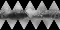
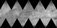
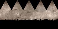
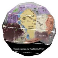
Icosahedral projection of Pluto map translated from scalbers map:
Icosahedral projection of Charon map translated from Bjorn Jonsson map:
|
||
|
|
|
||
|
Sep 6 2015, 08:51 AM
Post
#36
|
|||
|
Junior Member Group: Members Posts: 82 Joined: 13-July 15 Member No.: 7579 |
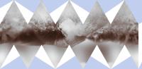
Color icosahedral projection of Pluto map from scalbers original map http://laps.noaa.gov/albers/sos/pluto/pluto_rgb_cyl_16k.png
Color icosahedral projection of Charon map from Bjorn Jonsson original map http://www.unmannedspaceflight.com/index.p...t&id=37406
|
||
|
|
|
||
|
Sep 6 2015, 11:35 AM
Post
#37
|
|
|
Senior Member Group: Members Posts: 2998 Joined: 30-October 04 Member No.: 105 |
What an interesting projections. Could it be printed, cut up and folded into a, uh, penta-whatever sphere?
--Bill -------------------- |
|
|
|
|
Sep 6 2015, 11:40 AM
Post
#38
|
||
|
Junior Member Group: Members Posts: 82 Joined: 13-July 15 Member No.: 7579 |
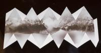
QUOTE (Bill Harris @ Sep 6 2015, 04:35 PM) What an interesting projections. Could it be printed, cut up and folded into a, uh, penta-whatever sphere? --Bill Yes, it is possible to glue the icosahedron. I wanted to do it, but in my printer ended magenta cartridge ... Cut off blue area after printing
|
|
|
|
|
|
|
Sep 6 2015, 12:47 PM
Post
#39
|
|||
|
Junior Member Group: Members Posts: 82 Joined: 13-July 15 Member No.: 7579 |
Printed
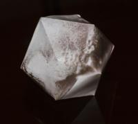
and glued icosahedron
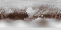
It does not look as good as thought. Not enough sphericity ... Icosahedral class I wrote for automatic construction of maps from LORRI images but not for making the globe. |
||
|
|
|
||
|
Sep 6 2015, 01:40 PM
Post
#40
|
|
 Member Group: Members Posts: 555 Joined: 27-September 10 Member No.: 5458 |
HAHA!
 Great seeing someone try it out Gennady. Seems like this could be a really good approximation for a globe. Translating the map into the strip could prove a bit more difficult. -------------------- |
|
|
|
|
Sep 6 2015, 04:04 PM
Post
#41
|
|
|
Senior Member Group: Members Posts: 2998 Joined: 30-October 04 Member No.: 105 |
QUOTE Yes, it is possible to glue the icosahedron... Great, then I'll piddle away some time with it. I have some printable card stock which should do well. There was someone here (and maybe still is here) who specialized in producing really nice foldable globes of planetary bodies. More faces than an isocktawhatever (sorry, it's been decades since Mineralogy/Crystallography Classes and I don't feel like counting on my fingers in Latin) and really detailed. Does anyone recall who that was? --Bill -------------------- |
|
|
|
|
Sep 6 2015, 08:04 PM
Post
#42
|
|
|
Member Group: Members Posts: 140 Joined: 20-November 07 Member No.: 3967 |
Might be me. I made those foldable maps of several asteroids, and Phobos and Deimos that got a bit of attention a few years ago. World maps with constant-scale natural boundaries, (samples at www.rightbasicbuilding.com). As well as maps of spherical bodies that also fold to solids. Trouble is, if trouble it be, that my maps of spherical bodies fold up to condensations of the sphere rather than nice spheres. Other projection systems based on platonic solids generate better spheres. Some better than others: the icosahedral is pointy; the daisy-hemispheres is pretty good. The "apple-peel" example above is especially nice! I've not seen it before; someone should take a bow.) So, anyway, mine come out lumpy or misshapen in an irregular manner that is a function of the natural boundary system selected as the map's border. The advantage is not so much the globe as it is the map itself, which is also irregular (sometimes highly irregular) but precisely so to display global patterns. A map of earth using (subsets of) continental divides is nice for contemplating global geomorphology, and can be rearranged for different perspectives on the subject. I'm highly intrigued by the new information on Pluto, and begin to strategize a boundary system to experiment with, similar to what my coauthor and I did at last year's lpsc with Miranda, Ganymede, Dione and Enceladus. Consider a bifurcating centroid-tree through Sputnik and then out the white lobes as a starting system. Not sure how far the apparent evidence could take it, perhaps branching again, from there. It may be possible to identify points of interest and districts of distinction on an unseen hemisphere based on large-scale organization of an observed hemisphere. At least for bodies with shell-like crusts in existence long enough to have attained gross equilibrium. (This worked especially well on Ganymede, and not too bad on Dione, but of course this was reverse engineering because those surfaces are known in entirety or nearly so.) Miranda was another test, but of course the back side will remain unseen for the foreseeable future. Pluto might be a nice test body for this conjecture, because some information about the hemisphere unobserved by New Horizons is in those 2011 blurry Hubble images, which some maps above have included. No promises. I may get distracted by 67-P Churyumov-Gerasimenko. Or maybe Bennu. |
|
|
|
|
Sep 6 2015, 08:24 PM
Post
#43
|
|
|
Senior Member Group: Members Posts: 3516 Joined: 4-November 05 From: North Wales Member No.: 542 |
Also JRehling did one for Titan - see here: https://www.google.co.uk/url?sa=t&rct=j...jCG0CjAYPLR3png
Something like that would be very nice for Pluto. |
|
|
|
|
Sep 6 2015, 09:39 PM
Post
#44
|
|
|
Member Group: Members Posts: 555 Joined: 27-September 10 Member No.: 5458 |
My knowledge of cartography is pretty limited so apologies if this isn't useful to many frequenting this thread. I was pretty fascinated when I saw that apple-peeling projection and set out to find anything I could. Seems like interest in such a projection is limited, at least from a flat perspective sense but seems pretty useful in making globes. The relevant function to generate the line is called a 'Rhumb Line' I believe which is essentially a line that crosses the longitudinal coordinates at a constant angle. Here's another page also about rhumb lines. Can't seem to find anyone else that has translated this into a physical model though.
I think to create what was in the video I posted earlier, he probably takes a stereographic polar map and then overlays the function line and then does the opposite for the other hemisphere. -------------------- |
|
|
|
|
Sep 6 2015, 11:29 PM
Post
#45
|
|
|
Junior Member Group: Members Posts: 30 Joined: 15-June 15 Member No.: 7506 |
QUOTE (ZLD @ Sep 6 2015, 02:39 PM) My knowledge of cartography is pretty limited so apologies if this isn't useful to many frequenting this thread. I was pretty fascinated when I saw that apple-peeling projection and set out to find anything I could. Seems like interest in such a projection is limited, at least from a flat perspective sense but seems pretty useful in making globes. The relevant function to generate the line is called a 'Rhumb Line' I believe which is essentially a line that crosses the longitudinal coordinates at a constant angle. Here's another page also about rhumb lines. Can't seem to find anyone else that has translated this into a physical model though. I think to create what was in the video I posted earlier, he probably takes a stereographic polar map and then overlays the function line and then does the opposite for the other hemisphere. Or there's this, a link from the page from the video, which appears to spit out something you can print given the proper input format, although I haven't tested it: http://print-sphere.com/ |
|
|
|
|
Sep 7 2015, 02:35 AM
Post
#46
|
|
|
Member Group: Members Posts: 555 Joined: 27-September 10 Member No.: 5458 |
If it were that simple, I can promise that I would have posted that. The person running that site does allow a person to upload an equirectangular projected map and and then submit it for purchase. I don't know if purchases are international or Japan only, didn't look that far into it. The function seems like it could be worked out with some time and MapMath for Gimp however.
-------------------- |
|
|
|
|
Sep 7 2015, 03:03 AM
Post
#47
|
||
|
Member Group: Members Posts: 148 Joined: 9-August 11 From: Mason, TX Member No.: 6108 |
Yesterday Greg Smyer-Rumsby of Astronomy Now tweeted this printable project. I can report that a ledger-size printout produces a globe (roughly speaking) about 6" across--a nice size for my office, taking a little over an hour to complete (including changing glues and finding thinner forming sticks as it came together).
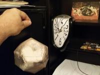
https://twitter.com/gregsmyerumsby/status/640137468071804929 Update: the result:
-------------------- --
Don |
|
|
|
|
|
|
Sep 9 2015, 03:43 PM
Post
#48
|
||
 Director of Galilean Photography Group: Members Posts: 896 Joined: 15-July 04 From: Austin, TX Member No.: 93 |
QUOTE (Req @ Sep 6 2015, 05:29 PM) Or there's this, a link from the page from the video, which appears to spit out something you can print given the proper input format, although I haven't tested it: http://print-sphere.com/ No, they don't provide you the flat image file, they only offer you a cut printout of the final image. I uploaded the Pluto proposed names map, here's their simulated shot showing Tombaugh Regio
Their price for a 14cm diameter made-to-order sphere is about $10.50 US. They also offer a 9cm for ~$8 and a 6cm for ~$5.50. I couldn't determine if they ship outside of Japan, maybe Panda or someone else who reads Japanese can check the website for us? Or ask if we can purchase just the output file? http://print-sphere.jp/hpgen/HPB/shop/policy.html -------------------- Space Enthusiast Richard Hendricks
-- "The engineers, as usual, made a tremendous fuss. Again as usual, they did the job in half the time they had dismissed as being absolutely impossible." --Rescue Party, Arthur C Clarke Mother Nature is the final inspector of all quality. |
|
|
|
|
|
|
Sep 13 2015, 06:51 AM
Post
#49
|
||||
|
Newbie Group: Members Posts: 2 Joined: 7-March 15 Member No.: 7410 |
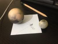
Hello folks. I've been a lurker for some time now, but I can't resist plugging myself in this thread.
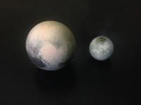
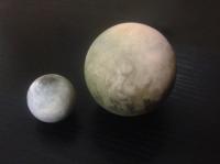
For some time now, I've been using 3d printing to make little astronomical globes, particularly of the most rarely found as a physical globes objects of the solar system. So for example, here's my Pluto & Charon to scale!
If you'd be interested in this sort of stuff you can find Pluto here: http://shpws.me/J6Ik And generally all my stuff here: https://www.shapeways.com/shops/yo3d I also make custom models and sets which can be of any size between 10-200m. So if you'd like something specific, or making use of a particular map I can upload a model and give you a private link to it! |
|||
|
|
|
|||
|
Sep 13 2015, 08:37 AM
Post
#50
|
|
|
Senior Member Group: Members Posts: 2998 Joined: 30-October 04 Member No.: 105 |
How neat-- I like your work. I've been interested in a model of the Comet Churyumov-Gerasimenko.
--Bill EDIT-- and let me add asteroid Ceres to the interest-list. -------------------- |
|
|
|
|
Sep 13 2015, 08:42 AM
Post
#51
|
|
|
Junior Member Group: Members Posts: 82 Joined: 13-July 15 Member No.: 7579 |
It's great! I also thought about how to print Pluto in 3D. But my printer is monochrome and would have to reflex color map by the surface heights ...
|
|
|
|
|
Sep 13 2015, 01:31 PM
Post
#52
|
|
|
Senior Member Group: Members Posts: 2998 Joined: 30-October 04 Member No.: 105 |
QUOTE (hendric) I couldn't determine if they ship outside of Japan... I frequently order motorcycle specialty electrical parts from a Japan-based company (Eastern Beaver) and shipping using Japan Postal is quick and painless. Japanese customs "info" is filled out on a label on the outside, I've never been questioned by US Customs and I've had USPS/UPS from the West Cost take longer to get here. I can't see how maps or DIY globes would be different. --Bill -------------------- |
|
|
|
|
Sep 14 2015, 01:54 PM
Post
#53
|
|
|
Director of Galilean Photography Group: Members Posts: 896 Joined: 15-July 04 From: Austin, TX Member No.: 93 |
Vaebn,
Great work! Bookmarked for future presents. Those tiny planets are just adorable.
-------------------- Space Enthusiast Richard Hendricks
-- "The engineers, as usual, made a tremendous fuss. Again as usual, they did the job in half the time they had dismissed as being absolutely impossible." --Rescue Party, Arthur C Clarke Mother Nature is the final inspector of all quality. |
|
|
|
|
Sep 15 2015, 01:37 AM
Post
#54
|
||
|
Newbie Group: Members Posts: 2 Joined: 7-March 15 Member No.: 7410 |
Bill (also see PM) / Gennady / Hendric. Thanks!
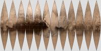
On a sidenote, here's another idea I have been toying with, you may be interested in. Nasa offers a wonderful free utility called g.projector that can take a cylindrical map and do various projections with it. http://www.giss.nasa.gov/tools/gprojector/ If someone takes a Pluto and/or other globe map, and did a "Sinusoidal" projection, and then in the settings selected the "30'' Gores" version of it, he ends up with a map like this:
Then, one could get styrofoam balls like these: http://goo.gl/P7m015 and simply... glue the pieces on to create a globe! (Only bit that needs some attention would be to ensure that the width of the printout matches the circumference of the globe) |
|
|
|
|
|
|
Sep 15 2015, 10:08 PM
Post
#55
|
||
|
Senior Member Group: Members Posts: 1639 Joined: 5-March 05 From: Boulder, CO Member No.: 184 |
I just put together a map version including some of the imagery from last week. Along with "raw" NH LORRI images, this utilizes the nicely done mosaic from Machi from 170000km distance, and an earlier one posted by Herobrine from a closer vantage point. HST from 1994 is in the southern hemisphere.
Still needs some cleanup, though for now the full resolution is here - http://stevealbers.net/albers/sos/sos.html#PLUTO. EDIT: Sept 17th 0000UTC - The "cleaned up" 8K and 16K hires images are now in place at the link above. -------------------- Steve [ my home page and planetary maps page ]
|
|
|
|
|
|
|
Sep 19 2015, 02:33 PM
Post
#56
|
|||||
|
Junior Member Group: Members Posts: 82 Joined: 13-July 15 Member No.: 7579 |
The first test of automatic map generation:
Pluto
Used frames: lor_0298270214_0x630_sci_3 lor_0298615084_0x630_sci_1 lor_0298721434_0x630_sci_1 lor_0298721464_0x630_sci_1 lor_0298721714_0x630_sci_1 lor_0298787064_0x630_sci_1 lor_0298787094_0x630_sci_1 lor_0298787344_0x630_sci_1 For example
|
||||
|
|
|
||||
|
Sep 19 2015, 04:21 PM
Post
#57
|
|
|
Member Group: Members Posts: 423 Joined: 13-November 14 From: Norway Member No.: 7310 |
QUOTE (scalbers @ Sep 16 2015, 12:08 AM) I just put together a map version including some of the imagery from last week. Along with "raw" NH LORRI images, this utilizes the nicely done mosaic from Machi from 170000km distance, and an earlier one posted by Herobrine from a closer vantage point. HST from 1994 is in the southern hemisphere. Hmm - wow, according to your map, we are really close to being able to spot the original "polygonal" feature from the approach images on the NH images we've seen thus far. Maybe limb shots taken several hours later can show parts of it? Part of the problem is of course that the rest of the limb might block it from view as NH flies closer to Pluto. -------------------- |
|
|
|
|
Sep 19 2015, 06:48 PM
Post
#58
|
||
|
Senior Member Group: Members Posts: 1639 Joined: 5-March 05 From: Boulder, CO Member No.: 184 |
This question (referring to Yutu Linea) has a good bit of fascination to it. It might show up near the limb of the sunlit crescent some hours after closest approach. The sun is rising just above the horizon from this location. The ground track takes some interesting turns as in this graphic excerpted from one of Alan Stern's presentations:
I rotated it so North is up. Yutu is about 35N latitude 0 longitude. The best viewing chance should be immediately after the ground track goes farthest to the right (in the southern hemisphere) after closest approach. This is after Pluto is eclipsing the sun. I'm unsure exactly how many hours after closest approach this ground track location is reached, though I see several LORRI opportunities that could cover this. It's really a close call though as a rough calculation has the center of Yutu being just a degree or two of great circle distance this side of the limb. Note that we never really go far enough westward prior to closest approach to catch this looking over the North Pole. It looks like the best possible view is just about the time of Machi's mosaic used in the map. -------------------- Steve [ my home page and planetary maps page ]
|
|
|
|
|
|
|
Sep 20 2015, 05:44 AM
Post
#59
|
|||||||
|
Junior Member Group: Members Posts: 82 Joined: 13-July 15 Member No.: 7579 |
The next approximation:
Pluto and Charon:
longitude-latitude projection:
Additionally used frames: lor_0298893474_0x630_sci_1 lor_0298893504_0x630_sci_1 lor_0298893754_0x630_sci_1 Example (restored from the maps view on the left):
|
||||||
|
|
|
||||||
|
Sep 20 2015, 05:07 PM
Post
#60
|
|||
|
Junior Member Group: Members Posts: 82 Joined: 13-July 15 Member No.: 7579 |
I take a picture area of the sky, where was Pluto and Charon:
RA = 18h 2m 25s Dec = -14° 39' 28" |
||
|
|
|
||
|
Dec 20 2015, 08:12 PM
Post
#61
|
|
|
Member Group: Members Posts: 140 Joined: 20-November 07 Member No.: 3967 |
|
|
|
|
|
Dec 21 2015, 10:02 PM
Post
#62
|
|
|
Senior Member Group: Members Posts: 2998 Joined: 30-October 04 Member No.: 105 |
Thanks, Chuck. Is a Charon foldable globe in the works?
AND while I'm thinking of it in the "places and names" section-- has there ever been a proclamation of official IAU names for the Pluto-Charon system? As far as I can see we're still ticking along with "unofficial names". Odd, since Ceres is updated with official names through this month. --Bill -------------------- |
|
|
|
|
Dec 22 2015, 03:34 PM
Post
#63
|
|
|
Member Group: Members Posts: 140 Joined: 20-November 07 Member No.: 3967 |
a Charon foldable globe?
Yes, Charon is on my radar, but awaiting the more complete coverage release they promise here: http://pluto.jhuapl.edu/Multimedia/Science...mp;image_id=264: "Many additional images now stored on the spacecrafts digital data recorders are expected to be transmitted "home" in fall 2015 and these will be used to complete the global map." I'm prepping the Pluto data now for LPSC 47. If anyone can convert the colorized Pluto image to a simple cylindrical, I'd be happy to immediately update the Pluto daisy-petal map. Anyone? c |
|
|
|
|
Mar 18 2016, 05:25 PM
Post
#64
|
|
|
Senior Member Group: Members Posts: 1639 Joined: 5-March 05 From: Boulder, CO Member No.: 184 |
Would someone be able to remind me where the best (possibly) official Pluto map is available? IIRC this is in "enhanced" color (IR/R/B) and about 18000 pixels across. It may or may not have feature names added. Thanks...
-------------------- Steve [ my home page and planetary maps page ]
|
|
|
|
|
Mar 18 2016, 07:56 PM
Post
#65
|
|
|
Member Group: Members Posts: 555 Joined: 27-September 10 Member No.: 5458 |
As far as I know, this is the current best map available. Its missing the other half of the imaged regions and is only a composition of the red and blue channels from MVIC though.
-------------------- |
|
|
|
|
Mar 19 2016, 02:40 PM
Post
#66
|
|
|
Senior Member Group: Members Posts: 2998 Joined: 30-October 04 Member No.: 105 |
Have we ever gotten official Pluto-system names or are we still moseying along with informal names?
--Bill -------------------- |
|
|
|
|
Mar 19 2016, 03:56 PM
Post
#67
|
|
|
Senior Member Group: Members Posts: 2517 Joined: 13-September 05 Member No.: 497 |
Other than the general categories, I don't see anything at http://planetarynames.wr.usgs.gov/ about official Pluto nomenclature.
See https://www.iau.org/public/themes/naming/ for a description of the process. -------------------- Disclaimer: This post is based on public information only. Any opinions are my own.
|
|
|
|
|
Mar 19 2016, 06:07 PM
Post
#68
|
|
 Senior Member Group: Members Posts: 1887 Joined: 20-November 04 From: Iowa Member No.: 110 |
I wonder if they have submitted the names, or if they are planning to use the names informally until it is too late for the IAU to overrule them.
|
|
|
|
|
Mar 19 2016, 07:03 PM
Post
#69
|
|
|
Senior Member Group: Members Posts: 2517 Joined: 13-September 05 Member No.: 497 |
QUOTE (alan @ Mar 19 2016, 10:07 AM) I wonder if they have submitted the names, or if they are planning to use the names informally until it is too late for the IAU to overrule them. What does "too late" mean? The MSL team sometimes uses "Mount Sharp" in publications, but it's never going to be an official IAU name. The NH team uses their names in LPSC abstracts, with a caveat of "all feature names here are informal". I expect we've got a few hundred years at least before the names of surface features on Pluto are of more than academic interest. I suspect the lack of progress is a mixture of the general slowness of the process and some real controversy. Perhaps surprisingly, the IAU seems to have blessed the use of Charon as the home of sci-fi names. On the other hand, some of the NH team's suggestions are likely never going to be approved by IAU because they simply don't fit with the established naming conventions. http://www.geekwire.com/2015/pluto-we-have...ly-on-iau-maps/ I'd guess this has been discussed ad nauseum on other threads. -------------------- Disclaimer: This post is based on public information only. Any opinions are my own.
|
|
|
|
|
Mar 21 2016, 06:41 PM
Post
#70
|
|
|
Senior Member Group: Members Posts: 1887 Joined: 20-November 04 From: Iowa Member No.: 110 |
QUOTE What does "too late" mean? Just that some of the names like Sputnik Planum are likely to be the only names most people will remember for the features no matter what the IAU decides. |
|
|
|
|
Mar 21 2016, 07:12 PM
Post
#71
|
|
|
Senior Member Group: Members Posts: 2998 Joined: 30-October 04 Member No.: 105 |
The IAU may been useful in the days when you documented a comet discovery by sending a telegram to Harvard, et al. I rather like the informal naming conventions on our non-planet system Pluto and Charon.
--Bill -------------------- |
|
|
|
|
Mar 21 2016, 10:14 PM
Post
#72
|
|
|
Senior Member Group: Members Posts: 2530 Joined: 20-April 05 Member No.: 321 |
A tale I've mentioned before:
The USGS map and some scientific paper(s) used different names for one of Europa's linea features. As far as I could tell, I was the first person to catch the discrepancy. And what of it? It's never going to be a household name. Both the USGS designations and the paper are and will always be obscure. For the difference between de jure and de facto to mean much, there has to be more than a trivial number of people paying attention. |
|
|
|
|
Mar 22 2016, 01:53 PM
Post
#73
|
|
|
Member Group: Members Posts: 244 Joined: 2-March 15 Member No.: 7408 |
At home, I have a browser plug-in configured to replace all occurrences of the word "official" with "IAU" in any paragraph that also contains the word "name" or "definition" on this site. My experience here improved significantly after I did that.
EDIT: In response to mcaplinger's post below (replying here so as not to continue the discussion below the red text (yes, I know that's cheating)): QUOTE (mcaplinger @ Mar 22 2016, 11:07 AM) So in my post above you read "The MSL team sometimes uses "Mount Sharp" in publications, but it's never going to be an official IAU name" as "it's never going to be an IAU IAU name"? Yeah, that seems helpful.  No; the browser plug-in I use lets me define substitutions using regular expressions, so I accounted for the "official IAU" case, as well as some other shouldn't-match cases using negative lookarounds. Seeing "official IAU" in your post was actually what made me think of it and decide to mention it.
|
|
|
|
|
Mar 22 2016, 03:07 PM
Post
#74
|
|
|
Senior Member Group: Members Posts: 2517 Joined: 13-September 05 Member No.: 497 |
QUOTE (Herobrine @ Mar 22 2016, 05:53 AM) At home, I have a browser plug-in configured to replace all occurrences of the word "official" with "IAU" in any paragraph that also contains the word "name" or "definition" on this site. So in my post above you read "The MSL team sometimes uses "Mount Sharp" in publications, but it's never going to be an official IAU name" as "it's never going to be an IAU IAU name"? Yeah, that seems helpful. -------------------- Disclaimer: This post is based on public information only. Any opinions are my own.
|
|
|
|
|
Mar 22 2016, 11:49 PM
Post
#75
|
|
|
Merciless Robot Group: Admin Posts: 8784 Joined: 8-December 05 From: Los Angeles Member No.: 602 |
MOD NOTE: Aaaaand that's the end of the IAU tangent here.
-------------------- A few will take this knowledge and use this power of a dream realized as a force for change, an impetus for further discovery to make less ancient dreams real.
|
|
|
|
|
Apr 26 2016, 10:29 PM
Post
#76
|
|
|
Member Group: Members Posts: 890 Joined: 18-November 08 Member No.: 4489 |
repost from a different forum
--- this is a VERY enhanced and cleaned up map with the missing data filed in with the data from "Marc Buie , et al" map i created years ago based on "PIA19956" and "PIA19858" 2k lores ( 0 to 360 !!! )  16k zip https://drive.google.com/file/d/0B6ZYAd08tZ...iew?usp=sharing |
|
|
|
|
Feb 23 2017, 07:14 PM
Post
#77
|
|
|
Senior Member Group: Members Posts: 1887 Joined: 20-November 04 From: Iowa Member No.: 110 |
|
|
|
|
|
Sep 7 2017, 04:12 PM
Post
#78
|
|
|
Member Group: Members Posts: 241 Joined: 16-May 06 From: Geneva, Switzerland Member No.: 773 |
Finally, Pluto features got their first official names by the IAU.
No big surprises, but it's good to be official. https://www.iau.org/news/pressreleases/detail/iau1704/ Regards, Marc. |
|
|
|
|
Jan 3 2018, 08:01 PM
Post
#79
|
|
|
Member Group: Members Posts: 423 Joined: 13-November 14 From: Norway Member No.: 7310 |
Pluto in Google Maps is quite nice: http://google.com/maps/space/pluto
-------------------- |
|
|
|
|
Apr 11 2018, 06:00 PM
Post
#80
|
|
|
Senior Member Group: Members Posts: 1583 Joined: 14-October 05 From: Vermont Member No.: 530 |
Charon IAU Nomenclature
http://pluto.jhuapl.edu/News-Center/News-A...p?page=20180411 Interestingly modern fictional characters have made a toehold. |
|
|
|
|
Jun 20 2020, 12:56 AM
Post
#81
|
|
|
Member Group: Members Posts: 227 Joined: 13-October 09 From: Olympus Mons Member No.: 4972 |
I made this map of Charon by combining the 12K USGS map with a map that was made from the Lowell Observatory back in 2000. I then overlaid color from the color IAU map and extrapolated color from one of the mid latitude grey areas into the southern hemisphere. I avoided using the color for the Mordor Regio (no official name yet for the giant north polar macula) or any other particularly dark area since the Lowell map shows the southern hemisphere to be brighter. It is interesting how well the albedo areas on the Lowell map roughly line up with the NH map.
https://live.staticflickr.com/65535/4998312...bd2b8db9a_o.png   This will likely be the highest coverage map of Charon until either something else flys by or a more powerful Earth based telescope images it. -------------------- "Thats no moon... IT'S A TRAP!"
|
|
|
|
|
Jul 5 2020, 01:03 PM
Post
#82
|
|
|
Member Group: Members Posts: 227 Joined: 13-October 09 From: Olympus Mons Member No.: 4972 |
16K Map of Pluto made by combining USGS map with additional areas from a map from NASA and using maps from Hubble to fill in most of the rest then a map from Lowell observatory to fill in that tiny south pole area. Color from the NASA map was overlain with extrapolation from mid latitudes for the southern hemisphere.
https://www.flickr.com/photos/60012030@N02/50079014212/ (2K preview) 
-------------------- "Thats no moon... IT'S A TRAP!"
|
|
|
|
|
Nov 23 2020, 11:39 PM
Post
#83
|
|
|
Member Group: Members Posts: 227 Joined: 13-October 09 From: Olympus Mons Member No.: 4972 |
I recently got a new computer. With it, I have constructed the highest resolution color map of Pluto. I had to divide it into 4 sections because Flickr wouldn't accept the 24K beast as one or even two pieces. The map can be seen in this album.
https://www.flickr.com/photos/60012030@N02/...157717015414428     https://www.flickr.com/photos/60012030@N02/...157717015414428 -------------------- "Thats no moon... IT'S A TRAP!"
|
|
|
|
|
Nov 24 2020, 01:01 AM
Post
#84
|
|
|
Merciless Robot Group: Admin Posts: 8784 Joined: 8-December 05 From: Los Angeles Member No.: 602 |
Spectacular. Great work!
-------------------- A few will take this knowledge and use this power of a dream realized as a force for change, an impetus for further discovery to make less ancient dreams real.
|
|
|
|
|
Dec 3 2020, 12:50 AM
Post
#85
|
|
 Member Group: Members Posts: 796 Joined: 27-February 08 From: Heart of Europe Member No.: 4057 |
QUOTE (Antdoghalo @ Nov 24 2020, 12:39 AM) I recently got a new computer. With it, I have constructed the highest resolution color map of Pluto. I had to divide it into 4 sections because Flickr wouldn't accept the 24K beast as one or even two pieces. The map can be seen in this album. Nice map Antdoghalo! Flickr allows images up to 200MB but size in pixels should not be limited so as long it's JPEG with such compression that it's smaller than 200MB, it should be fine. My largest image on Flickr has size 24 000 × 20 300. -------------------- |
|
|
|
|
Feb 4 2022, 07:40 PM
Post
#86
|
|
|
Member Group: Members Posts: 436 Joined: 14-December 15 Member No.: 7860 |
I don't know if I'm posting this in the right topic...
Reading Alan Stern's December 17, 2021 post "The PI's Perspective: Looking Back, Looking Forward" on the New Horizons website - http://pluto.jhuapl.edu/News-Center/PI-Per...tive_12_17_2021 - I noticed this excerpt: „For this update, I also want to mention to you that a number of Pluto system and Arrokoth surfaces features have received official names that our project team proposed (...) They also include the first surface feature named on Pluto’s moon Nix, and an official name, “Sky,” for Arrokoth’s largest crater.” However, I can not find maps, pictures or even some sketches with these new names on Arrokoth and Nix, or any further information on this matter anywhere. Can anyone help me please? |
|
|
|
|
Feb 4 2022, 08:45 PM
Post
#87
|
|
|
Senior Member Group: Members Posts: 2517 Joined: 13-September 05 Member No.: 497 |
QUOTE (Marcin600 @ Feb 4 2022, 11:40 AM) However, I can not find maps, pictures or even some sketches with these new names on Arrokoth and Nix, or any further information on this matter anywhere. Can anyone help me please? Presumably they just haven't updated https://planetarynames.wr.usgs.gov/ yet -- the last update was in early December 2021. -------------------- Disclaimer: This post is based on public information only. Any opinions are my own.
|
|
|
|
|
Feb 8 2022, 06:23 PM
Post
#88
|
|
|
Member Group: Members Posts: 436 Joined: 14-December 15 Member No.: 7860 |
QUOTE (mcaplinger @ Feb 4 2022, 09:45 PM) Presumably they just haven't updated https://planetarynames.wr.usgs.gov/ yet -- the last update was in early December 2021. Thank you. In fact, there is probably some delay (e.g. there are also no maps/pictures with names on the surfaces of Bennu and Ryugu on the IAU website). |
|
|
|
|
Feb 15 2022, 12:53 AM
Post
#89
|
||
|
Member Group: Members Posts: 436 Joined: 14-December 15 Member No.: 7860 |
And here it is!!!
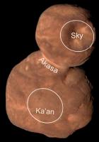
Thank you! http://pluto.jhuapl.edu/News-Center/News-A...p?page=20220210 (Credit: NASA/Johns Hopkins APL/Southwest Research Institute)
Attached thumbnail(s)
|
|
|
|
|
|
|

|
Lo-Fi Version | Time is now: 23rd May 2024 - 04:19 AM |
|
RULES AND GUIDELINES Please read the Forum Rules and Guidelines before posting. IMAGE COPYRIGHT |
OPINIONS AND MODERATION Opinions expressed on UnmannedSpaceflight.com are those of the individual posters and do not necessarily reflect the opinions of UnmannedSpaceflight.com or The Planetary Society. The all-volunteer UnmannedSpaceflight.com moderation team is wholly independent of The Planetary Society. The Planetary Society has no influence over decisions made by the UnmannedSpaceflight.com moderators. |
SUPPORT THE FORUM Unmannedspaceflight.com is funded by the Planetary Society. Please consider supporting our work and many other projects by donating to the Society or becoming a member. |
|