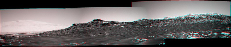
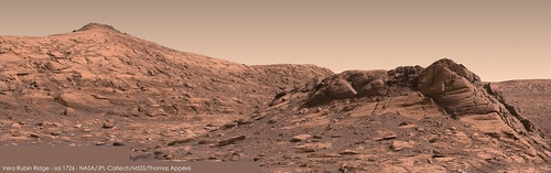
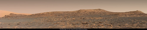
Along the base of Vera Rubin Ridge, (Sites 64-65, Sols 1726-1812, Jun 14-Sep 11 2017) |

  |
Along the base of Vera Rubin Ridge, (Sites 64-65, Sols 1726-1812, Jun 14-Sep 11 2017) |
 Jun 15 2017, 07:09 AM Jun 15 2017, 07:09 AM
Post
#1
|
|
|
Member  Group: Members Posts: 362 Joined: 13-April 06 From: Malta Member No.: 741 |
Time for a new topic in line with Curiosity's new location.
|
 |
 
|
|
Jun 15 2017, 04:57 PM
Post
#2
|
|||
|
Member Group: Members Posts: 923 Joined: 10-November 15 Member No.: 7837 |
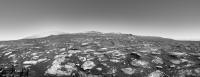
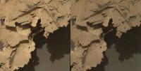
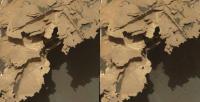
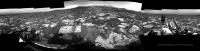
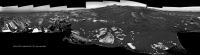
MSL 1726 with extended sky...
 left
right
-------------------- |
||
|
|
|
||
|
Jun 15 2017, 05:07 PM
Post
#3
|
|
 Senior Member Group: Members Posts: 4252 Joined: 17-January 05 Member No.: 152 |
QUOTE (Julius @ Jun 15 2017, 08:09 AM)  Time for a new topic in line with Curiosity's new location. It's not so much a new location as a new, extended view... |
|
|
|
|
Jun 15 2017, 11:26 PM
Post
#4
|
||
 Senior Member Group: Members Posts: 2430 Joined: 30-January 13 From: Penang, Malaysia. Member No.: 6853 |
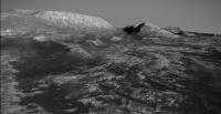
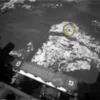
EDITED Having no luck with the 1727 end-of-drive NavCams using MS ICE... So here is a roughly assembled long distance (~100 meters) RMI Mosaic of a section the Vera Rubin Ridge, only four of the 5 frames have been released as 'enhanced data products'.
|
|
|
|
|
|
|
Jun 16 2017, 03:30 PM
Post
#5
|
|
|
Member Group: Members Posts: 923 Joined: 10-November 15 Member No.: 7837 |
Here is 2km square of Vera Rubin Ridge & beyond made with best available HiRISE data & compressed to fit within Sketchfab constraints.
 Vera Rubin Ridge @Sketchfab [ 2km square ] The 8k texture limit covers approx 2km sq. Scaled for VR so you can start wandering from Sol 1727 location. -------------------- |
|
|
|
|
Jun 16 2017, 07:24 PM
Post
#6
|
||
|
Senior Member Group: Members Posts: 2841 Joined: 22-April 05 From: Ridderkerk, Netherlands Member No.: 353 |
The Navcam L view on Sol 1726.
Jan van Driel
|
|
|
|
|
|
|
Jun 17 2017, 12:41 AM
Post
#7
|
||
|
Senior Member Group: Members Posts: 2430 Joined: 30-January 13 From: Penang, Malaysia. Member No.: 6853 |
1728 L-NavCam (MS ICE) after a drive to the East.
|
|
|
|
|
|
|
Jun 17 2017, 11:00 AM
Post
#8
|
||
|
Senior Member Group: Members Posts: 2430 Joined: 30-January 13 From: Penang, Malaysia. Member No.: 6853 |
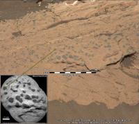
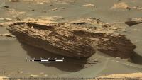
Cropped 1727 R-MastCam mosaic (2 frames in MS ICE, sharpened with 1 meter-long scale bar added), features what I believe to be Spaulding Mountain The sedimentary layers appear to be a little odd / puzzling for mudstone? Likely a valid explanation for these cross bedding like features (thin mineral filled fractures?)

|
|
|
|
|
|
|
Jun 17 2017, 11:20 AM
Post
#9
|
||
|
Member Group: Members Posts: 923 Joined: 10-November 15 Member No.: 7837 |
Slightly ahead of schedule...here is the 2km tile beyond Vera Rubin Ridge using best available HiRISE data squished into Sketchfab & scaled for VR
Beyond Vera Rubin Ridge @Sketchfab -------------------- |
|
|
|
|
|
|
Jun 17 2017, 01:13 PM
Post
#10
|
||
|
Senior Member Group: Members Posts: 2841 Joined: 22-April 05 From: Ridderkerk, Netherlands Member No.: 353 |
The Navcam L view on Sol 1727.
Jan van Driel
|
|
|
|
|
|
|
Jun 17 2017, 02:25 PM
Post
#11
|
||
|
Senior Member Group: Members Posts: 2841 Joined: 22-April 05 From: Ridderkerk, Netherlands Member No.: 353 |
and the Navcam L view on Sol 1728.
Jan van Driel
|
|
|
|
|
|
|
Jun 18 2017, 12:34 AM
Post
#12
|
||
|
Solar System Cartographer Group: Members Posts: 10193 Joined: 5-April 05 From: Canada Member No.: 227 |
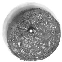
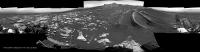
This is Jan's panorama for sol 1726 - the one clearly showing the ridge - in circular form.
Phil
-------------------- ... because the Solar System ain't gonna map itself.
Also to be found posting similar content on https://mastodon.social/@PhilStooke Maps for download (free PD: https://upload.wikimedia.org/wikipedia/comm...Cartography.pdf NOTE: everything created by me which I post on UMSF is considered to be in the public domain (NOT CC, public domain) |
|
|
|
|
|
|
Jun 18 2017, 09:02 AM
Post
#13
|
|||
|
Senior Member Group: Members Posts: 2430 Joined: 30-January 13 From: Penang, Malaysia. Member No.: 6853 |
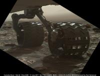
The first of wheel checkout MAHLI images acquired on 1729 are down. Lovely lighting and superb location.
Link to all images Link |
||
|
|
|
||
|
Jun 18 2017, 11:09 AM
Post
#14
|
|
|
Member Group: Members Posts: 923 Joined: 10-November 15 Member No.: 7837 |
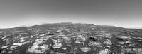
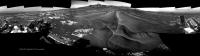
Debayered & extended sky of Vera Rubin Ridge, Sol 1726
    -------------------- |
|
|
|
|
Jun 18 2017, 05:31 PM
Post
#15
|
|
 Member Group: Members Posts: 816 Joined: 3-June 04 From: Brittany, France Member No.: 79 |
My take on this MC100 mosaic of Vera Rubin Ridge:
-------------------- |
|
|
|
|
Jun 19 2017, 02:01 AM
Post
#16
|
|
|
Senior Member Group: Members Posts: 2430 Joined: 30-January 13 From: Penang, Malaysia. Member No.: 6853 |
Impressive work debayering / processing those MastCams
|
|
|
|
|
Jun 19 2017, 09:46 PM
Post
#17
|
|
|
Member Group: Members Posts: 866 Joined: 15-March 05 From: Santa Cruz, CA Member No.: 196 |
|
|
|
|
|
Jun 19 2017, 10:53 PM
Post
#18
|
|
 Administrator Group: Admin Posts: 5172 Joined: 4-August 05 From: Pasadena, CA, USA, Earth Member No.: 454 |
Every time I think the rock textures can't get weirder, Curiosity proves me wrong. Thanks for the 3D views.
And Sean, those Sketchfab VR things are awesome. -------------------- My website - My Patreon - @elakdawalla on Twitter - Please support unmannedspaceflight.com by donating here.
|
|
|
|
|
Jun 20 2017, 02:28 PM
Post
#19
|
||
|
Senior Member Group: Members Posts: 2841 Joined: 22-April 05 From: Ridderkerk, Netherlands Member No.: 353 |
The Navcam L view on Sol 1730
Jan van Driel
|
|
|
|
|
|
| Guest_Steve5304_* |
Jun 21 2017, 12:21 PM
Post
#20
|
|
|
Guests |
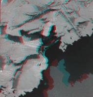
QUOTE (atomoid @ Jun 19 2017, 10:46 PM) Thanks for the Sketchfabs Sean, I will say it enhances my quality of life flying around future MSL terrain like this! Here's an interssting composition from sol1729, plus an obligartory sol1728 stereo crosseye.
That is interesting...I bet that is so brittle it would shatter like glass at if you dropped a pin. ...looks like Plaster at a right angle on potato chip ledge. I guess the low gravity atmosphere allows brittle and unsound structures to last longer than here on earth. Reminds me of when people mix copper and caste pipes a process begins called electrolysis which destroy both and you get pits, waves and right angles just like that rock. Interesting |
|
|
|
|
|
|
Jun 21 2017, 01:00 PM
Post
#21
|
|
|
Member Group: Members Posts: 923 Joined: 10-November 15 Member No.: 7837 |
I have updated the Vera Rubin Sketchfab model to color...
 Vera Rubin Ridge @Sketchfab How to get started with Sketchfab VR -------------------- |
|
|
|
|
Jun 22 2017, 05:06 AM
Post
#22
|
||
|
Solar System Cartographer Group: Members Posts: 10193 Joined: 5-April 05 From: Canada Member No.: 227 |
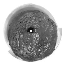
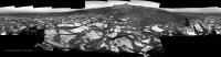
This is a circular version of Jan's 1730 panorama. Many of the blocks are large enough to show up clearly in HiRISE images.
Phil
-------------------- ... because the Solar System ain't gonna map itself.
Also to be found posting similar content on https://mastodon.social/@PhilStooke Maps for download (free PD: https://upload.wikimedia.org/wikipedia/comm...Cartography.pdf NOTE: everything created by me which I post on UMSF is considered to be in the public domain (NOT CC, public domain) |
|
|
|
|
|
|
Jun 22 2017, 12:08 PM
Post
#23
|
||
|
Member Group: Members Posts: 923 Joined: 10-November 15 Member No.: 7837 |
MSL 1732...
 Maybe our path onto Vera Rubin Ridge is just left of center?... looks inviting! Detail...  
-------------------- |
|
|
|
|
|
|
Jun 22 2017, 06:09 PM
Post
#24
|
|
|
Member Group: Members Posts: 122 Joined: 19-June 07 Member No.: 2455 |
A few questions to those in the know.
I saw today that a solar conjunction is coming up soon. What is the exact timing of that and do we plan on being atop Vera Rubin Ridge throughout it? Secondly, because we've been climbing up this hill, the giant mesas at the base of Mt. Sharp have been hidden from view. I would imagine that the view from atop Vera Rubin Ridge will once again expose that dramatic geography and that they'll be considerably closer than when they disappeared. The photographs should be stunning. Am I right in my assumption? Third, are there any upcoming sections of the trek ahead that appear particularly perilous with real questions as to whether the rover can navigate over the rugged and steep terrain especially with the degraded wheels? Lastly, I've seen a number of daily updates that talk about doing further drill diagnosis but no indications at all about the outlook on being able to use this tool. Any insight on this? |
|
|
|
|
Jun 22 2017, 06:57 PM
Post
#25
|
|
|
Member Group: Members Posts: 541 Joined: 17-November 05 From: Oklahoma Member No.: 557 |
In regards to the drill, Emily Lakdawalla posted on the Planetary Society's blog last week:
Curiosity Update QUOTE A problem with the brake on the rover's drill feed mechanism that occurred back in December is still preventing its use, and there's currently no estimate of when (if ever) it will return to action. QUOTE As Curiosity approaches the top of the Murray formation and journeys into new rock units, it would be a really good time for the drill to come back into service. Unfortunately, there is no estimate for when that may happen. Engineers have been hard at work testing the drill, trying to develop methods to reliably advance the drill feed. Project scientist Ashwin Vasavada tells me that the experiments they've been performing have borne some fruit but have not led to a solution that allows the drill feed to function reliably. They're shifting now from trying electronic solutions to the balky drill feed (like adjusting voltages, using one or the other or both brake coils) to mechanical solutions (experimenting with the orientation of the drill and with the use of vibration and percussion at different levels). And because it's been so long since the last successful drill attempt, on sol 1495 at Sebina, the project is beginning to expend some effort to explore some "less standard uses of the drill" that would bypass the use of the drill feed altogether for sampling activity. Let's all hope it doesn't come to that, but I'm glad they're preparing for the possibility that the drill feed mechanism might be unrecoverable. In regards to the current situation facing the wheels, and the blocky terrain ... QUOTE One piece of good news about the changing terrain: despite the increasing blockiness of the Murray, there's been no acceleration in wheel damage. Rover drivers can steer around many of the blocks. Even when wheels have to confront rock, Murray formation rock is soft enough that Curiosity's wheels tend to crush it, unlike the Bradbury rocks that used to puncture the wheels' thin skin. |
|
|
|
|
Jun 22 2017, 07:52 PM
Post
#26
|
||
|
Senior Member Group: Members Posts: 2841 Joined: 22-April 05 From: Ridderkerk, Netherlands Member No.: 353 |
The Navcam L view on Sol 1732-1733.
Jan van Driel
|
|
|
|
|
|
|
Jun 23 2017, 12:11 AM
Post
#27
|
||
|
Member Group: Members Posts: 923 Joined: 10-November 15 Member No.: 7837 |
A simulated Curiosity ( scaled by HiRISE ) climbs Vera Rubin Ridge ( Sol 1732 )
 Detail... 
-------------------- |
|
|
|
|
|
|
Jun 23 2017, 02:56 AM
Post
#28
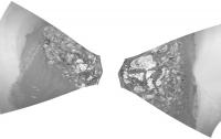
|
|||
|
Senior Member Group: Members Posts: 2430 Joined: 30-January 13 From: Penang, Malaysia. Member No.: 6853 |
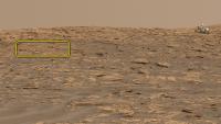
Quick and Dirty 10x2 RMI telephoto mosaic featuring a small section of 'Northern Neck' targeted on sol 1734. One of the frames (lower center) was not available as an enhanced data product when I assembled the mosaic. I've patched it as well as possible within the limitations of MS ICE and my basic skills. Hoping for a better version to be posted here
EDIT: I've identified the target area on a crop from Sean's CG mosaic
Mods please feel free to delete as better versions are posted PS Great work Sean, love the CG Curi on the Ridge
|
||
|
|
|
||
|
Jun 23 2017, 06:14 AM
Post
#29
|
||
|
Founder Group: Chairman Posts: 14433 Joined: 8-February 04 Member No.: 1 |
QUOTE (jvandriel @ Jun 22 2017, 12:52 PM) The Navcam L view on Sol 1732-1733. Jan van Driel
Yeahhhh....my bad on cutting that tiny piece off Mt Sharp with the upper tier. Couldn't convince myself I could still get all of VRR if I nudged it any more left. Fingers crossed I can try again on Monday. |
|
|
|
|
|
|
Jun 23 2017, 01:25 PM
Post
#30
|
||
|
Senior Member Group: Members Posts: 2841 Joined: 22-April 05 From: Ridderkerk, Netherlands Member No.: 353 |
The Navcam L view on Sol 1734
Jan van Driel
|
|
|
|
|
|
|
Jun 23 2017, 07:52 PM
Post
#31
|
|
|
Member Group: Members Posts: 816 Joined: 3-June 04 From: Brittany, France Member No.: 79 |
My take on the MC34 mosaic of sol 1732:
-------------------- |
|
|
|
|
Jun 24 2017, 02:18 AM
Post
#32
|
||
|
Senior Member Group: Members Posts: 2430 Joined: 30-January 13 From: Penang, Malaysia. Member No.: 6853 |
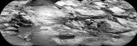
Sol 1734: 2 frame R-MastCam mosaic, part of a multi-spectral session. Provides detailed Stratigraphy / better context for the 10x2 telephoto ChemCam-RMI mosaic of Northern Neck on the Vera Rubin Ridge that I posted yesterday, processed in MS ICE.
|
|
|
|
|
|
|
Jun 25 2017, 06:25 AM
Post
#33
|
|||
|
Senior Member Group: Members Posts: 2430 Joined: 30-January 13 From: Penang, Malaysia. Member No.: 6853 |
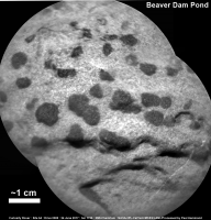
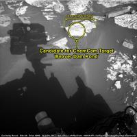
A simple 2 frame ChemCam-RMI mosaic from sol 1736, of what I believe could be the target referred to as 'Beaver Dam Pond' in the latest mission update ('a block of the Murray formation that may have been tilted on its side'). Roughly assembled in MS ICE without further image processing. Also added a L-NavCam frame from 1734 which I believe contains the target block. I used AlgorimancerPG to establish the scales on the NavCam, this was then transposed onto the RMI. Once we have the context R-MastCam frame, I hope to be able to check the scale on the RMI. In the meantime, maybe we are seeing some more concretions, similar to those observed on Sol 1718? Refer to Atomoid's post and subsequent replies
|
||
|
|
|
||
|
Jun 26 2017, 04:48 PM
Post
#34
|
|
|
Founder Group: Chairman Posts: 14433 Joined: 8-February 04 Member No.: 1 |
QUOTE (jvandriel @ Jun 22 2017, 12:52 PM) The Navcam L view on Sol 1732-1733. Trying an upper tier again in Sol 1739 plan......fingers crossed I get all the things this time. |
|
|
|
|
Jun 27 2017, 01:13 AM
Post
#35
|
||
|
Senior Member Group: Members Posts: 2430 Joined: 30-January 13 From: Penang, Malaysia. Member No.: 6853 |
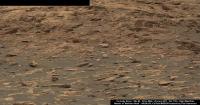
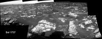
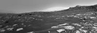
Sol 1737 partial R-NavCam pan after the drive East (MS ICE)
|
|
|
|
|
|
|
Jun 27 2017, 06:15 AM
Post
#36
|
||
|
Senior Member Group: Members Posts: 2430 Joined: 30-January 13 From: Penang, Malaysia. Member No.: 6853 |
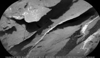
Sol 1737 RMI mosaic (3 frames assembled in MS ICE)
|
|
|
|
|
|
|
Jun 28 2017, 01:57 AM
Post
#37
|
||
|
Senior Member Group: Members Posts: 2430 Joined: 30-January 13 From: Penang, Malaysia. Member No.: 6853 |
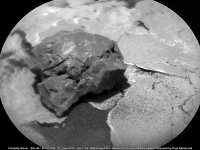
RMI mosaic from 2 frames acquired on sol 1739 (MS ICE, sharpened). Thoughts on what this may be?
|
|
|
|
|
|
|
Jun 28 2017, 03:25 AM
Post
#38
|
|
|
Merciless Robot Group: Admin Posts: 8784 Joined: 8-December 05 From: Los Angeles Member No.: 602 |
Kinda shiny, kinda dark, so my guess would be a little meteorite.
-------------------- A few will take this knowledge and use this power of a dream realized as a force for change, an impetus for further discovery to make less ancient dreams real.
|
|
|
|
|
Jun 28 2017, 04:30 AM
Post
#39
|
|
|
Solar System Cartographer Group: Members Posts: 10193 Joined: 5-April 05 From: Canada Member No.: 227 |
Yes, could be!
Phil -------------------- ... because the Solar System ain't gonna map itself.
Also to be found posting similar content on https://mastodon.social/@PhilStooke Maps for download (free PD: https://upload.wikimedia.org/wikipedia/comm...Cartography.pdf NOTE: everything created by me which I post on UMSF is considered to be in the public domain (NOT CC, public domain) |
|
|
|
|
Jun 28 2017, 04:50 AM
Post
#40
|
|
|
Senior Member Group: Members Posts: 4252 Joined: 17-January 05 Member No.: 152 |
If anyone's up for a June Easter egg hunt, I think it's in this frame...
http://mars.jpl.nasa.gov/msl-raw-images/pr...NCAM00375M_.JPG |
|
|
|
|
Jun 28 2017, 07:17 AM
Post
#41
|
||
|
Senior Member Group: Members Posts: 2430 Joined: 30-January 13 From: Penang, Malaysia. Member No.: 6853 |
QUOTE (fredk @ Jun 28 2017, 12:50 PM) If anyone's up for a June Easter egg hunt, I think it's in this frame... If this is the target, then it's probably ~40mm wide, should be able to get a better handle on the size once we have the R-MastCam context image that they often acquire with ChemCam images.
|
|
|
|
|
|
|
Jun 28 2017, 07:52 AM
Post
#42
|
|
|
Senior Member Group: Members Posts: 2430 Joined: 30-January 13 From: Penang, Malaysia. Member No.: 6853 |
|
|
|
|
|
Jun 28 2017, 08:31 AM
Post
#43
|
||
|
Senior Member Group: Members Posts: 2841 Joined: 22-April 05 From: Ridderkerk, Netherlands Member No.: 353 |
The Navcam L view on Sol 1737.
Jan van Driel
|
|
|
|
|
|
|
Jun 28 2017, 01:06 PM
Post
#44
|
||
|
Senior Member Group: Members Posts: 2430 Joined: 30-January 13 From: Penang, Malaysia. Member No.: 6853 |
Partial L-NavCam 1739 (including what we have of the top tier
Mods feel free to delete as the full pan is posted
|
|
|
|
|
|
|
Jun 28 2017, 02:51 PM
Post
#45
|
||
|
Member Group: Members Posts: 923 Joined: 10-November 15 Member No.: 7837 |
Extended sky from 1739...

-------------------- |
|
|
|
|
|
|
Jun 28 2017, 05:11 PM
Post
#46
|
|
|
Founder Group: Chairman Posts: 14433 Joined: 8-February 04 Member No.: 1 |
There's a few more frames down - it should now be a complete 360 with no trimmed horizon anywhere
|
|
|
|
|
Jun 28 2017, 07:12 PM
Post
#47
|
||
|
Senior Member Group: Members Posts: 2841 Joined: 22-April 05 From: Ridderkerk, Netherlands Member No.: 353 |
The Navcam L view on Sol 1739.
Jan van Driel
|
|
|
|
|
|
| Guest_Steve5304_* |
Jun 28 2017, 08:22 PM
Post
#48
|
|
Guests |
QUOTE (fredk @ Jun 28 2017, 05:50 AM) If anyone's up for a June Easter egg hunt, I think it's in this frame... http://mars.jpl.nasa.gov/msl-raw-images/pr...NCAM00375M_.JPG The Slab appears to have shifted to the right?? Compared to prevouis sol the rover was nowhere near it. Cool. What did that |
|
|
|
|
Jun 28 2017, 11:15 PM
Post
#49
|
|
|
Senior Member Group: Members Posts: 1045 Joined: 17-February 09 Member No.: 4605 |
There seems to be minor subsidence at the edge of the slab but no movement of the slab itself. This is a reasonably common phenomenon observed by MER and MSL and could have something to do with rover proximity.
|
|
|
|
|
Jun 28 2017, 11:48 PM
Post
#50
|
|||
|
Solar System Cartographer Group: Members Posts: 10193 Joined: 5-April 05 From: Canada Member No.: 227 |
Jan's last two panoramas in circular form to show the local area in map form. Soon we will be seeing a broader view of the ridge and the slope we will climb.
Phil 1737:
1739:
-------------------- ... because the Solar System ain't gonna map itself.
Also to be found posting similar content on https://mastodon.social/@PhilStooke Maps for download (free PD: https://upload.wikimedia.org/wikipedia/comm...Cartography.pdf NOTE: everything created by me which I post on UMSF is considered to be in the public domain (NOT CC, public domain) |
||
|
|
|
||
|
Jun 29 2017, 06:10 AM
Post
#51
|
|
|
Senior Member Group: Members Posts: 2430 Joined: 30-January 13 From: Penang, Malaysia. Member No.: 6853 |
|
|
|
|
|
Jun 29 2017, 01:37 PM
Post
#52
|
||
|
Member Group: Members Posts: 923 Joined: 10-November 15 Member No.: 7837 |
MSl 1739 360 NR extended sky
 cropped  ( I should have extended the exposure glare to the sun! Next time... ) resized, compressed & attached
-------------------- |
|
|
|
|
|
|
Jun 29 2017, 02:56 PM
Post
#53
|
||
|
Member Group: Members Posts: 149 Joined: 18-June 08 Member No.: 4216 |
QUOTE (PaulH51 @ Jun 29 2017, 07:10 AM) Not as polished as some of the nickel-iron meteorites spotted earlier by MSL! Not sure if LIBS was used on this target? Presented here in its Sol 1739 R-MastCam context image to support the RMI image Link Interestingly (or not) it failed to get a mention in the latest mission update Link
(raw image) do those dark-coloured bits on the right of the meteorite look like fragments? I haven't seen that before. |
|
|
|
|
|
|
Jun 29 2017, 10:06 PM
Post
#54
|
|
|
Member Group: Members Posts: 866 Joined: 15-March 05 From: Santa Cruz, CA Member No.: 196 |
i wasn't thinking meteorite itself, only basaltic bedrock fragments induced by an impact, but LIBS should reveal, and there do appear to be the usual pattern of LIBS hits most visible in the shadowed portion at right sol1739 RMI image.. The mission update mentions "..We have ChemCam LIBS observations of targets named "Hamilton Pond," "Whalesback," and Rice Point."
|
|
|
|
|
Jun 30 2017, 03:14 AM
Post
#55
|
|
|
Senior Member Group: Members Posts: 2430 Joined: 30-January 13 From: Penang, Malaysia. Member No.: 6853 |
QUOTE (atomoid @ Jun 30 2017, 06:06 AM) i wasn't thinking meteorite itself, only basaltic bedrock fragments induced by an impact, but LIBS should reveal, and there do appear to be the usual pattern of LIBS hits most visible in the shadowed portion at right . The mission update mentions "..We have ChemCam LIBS observations of targets named "Hamilton Pond," "Whalesback," and Rice Point." Good eyes Here is a quickly assembled animated GIF:
|
|
|
|
|
Jun 30 2017, 09:44 AM
Post
#56
|
||
|
Senior Member Group: Members Posts: 2430 Joined: 30-January 13 From: Penang, Malaysia. Member No.: 6853 |
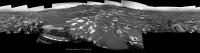
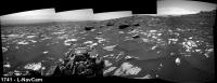
Sol 1741 L-NavCam partial pan after another drive (~ENE). Very roughly assembled using MS ICE: mods please feel free to delete after full size, or better version is posted.
|
|
|
|
|
|
|
Jun 30 2017, 03:25 PM
Post
#57
|
|
 Senior Member Group: Members Posts: 1619 Joined: 12-February 06 From: Bergerac - FR Member No.: 678 |
Very nice Sean
Here is my take on this beautiful panoramic : 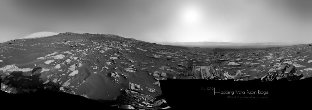 -------------------- |
|
|
|
|
Jun 30 2017, 03:49 PM
Post
#58
|
|
|
Member Group: Members Posts: 923 Joined: 10-November 15 Member No.: 7837 |
Beautiful work Damia! I much prefer yours.
-------------------- |
|
|
|
|
Jun 30 2017, 08:56 PM
Post
#59
|
||
|
Solar System Cartographer Group: Members Posts: 10193 Joined: 5-April 05 From: Canada Member No.: 227 |
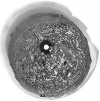
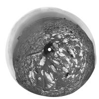
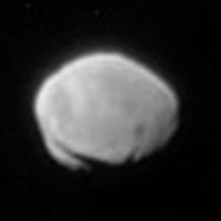
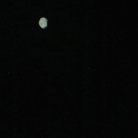
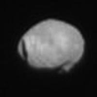
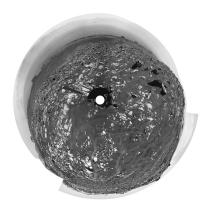
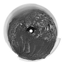
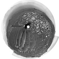
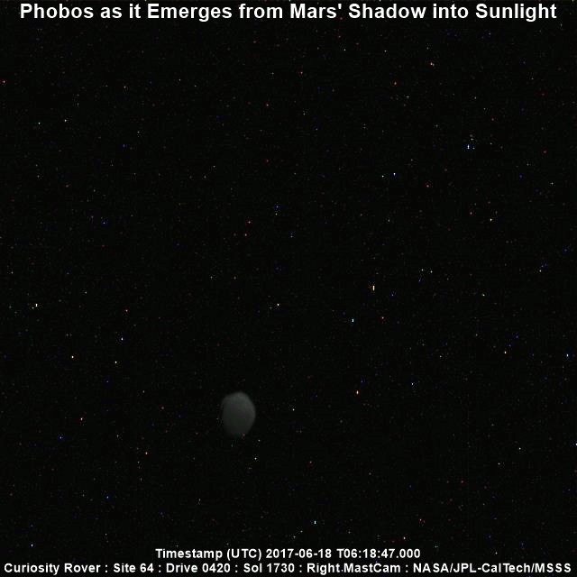
This is Phobos as seen on sol 1730, a 4x enlargement with six images merged and individually processed. Stickney on the left.
Phil
-------------------- ... because the Solar System ain't gonna map itself.
Also to be found posting similar content on https://mastodon.social/@PhilStooke Maps for download (free PD: https://upload.wikimedia.org/wikipedia/comm...Cartography.pdf NOTE: everything created by me which I post on UMSF is considered to be in the public domain (NOT CC, public domain) |
|
|
|
|
|
|
Jul 1 2017, 01:03 AM
Post
#60
|
||
|
Member Group: Members Posts: 866 Joined: 15-March 05 From: Santa Cruz, CA Member No.: 196 |
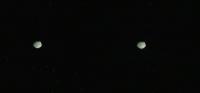
really nice exposure they managed to get as it presumably came out of the penumbra, shown here in cross-eye because (despite the orbital motion) it's so much closer than the stars!
|
|
|
|
|
|
|
Jul 1 2017, 04:33 AM
Post
#61
|
||
|
Senior Member Group: Members Posts: 2430 Joined: 30-January 13 From: Penang, Malaysia. Member No.: 6853 |
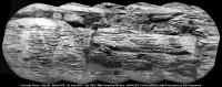
Sol 1741 RMI mosaic featuring the stratigraphy of another section of the Vera Rubin Ridge, not sure about scale, but I estimate the distance to be around 80-85 meters South of the rover (distance depends on its position on the slope). There was another RMI frame, sadly that had data drop-out, not sure if it belonged to the same set or a different section. Assembled in MS ICE and rotated, not sharpened or processed other than stitching in MS ICE.
|
|
|
|
|
|
|
Jul 1 2017, 05:40 AM
Post
#62
|
|
 Senior Member Group: Members Posts: 1444 Joined: 26-July 08 Member No.: 4270 |
Has there been any consideration of looking at Phobos through ChemCam? It's certainly something I would do if I were on Mars with a telescope.
-------------------- -- Hungry4info (Sirius_Alpha)
|
|
|
|
|
Jul 1 2017, 09:30 AM
Post
#63
|
|
|
Senior Member Group: Members Posts: 2430 Joined: 30-January 13 From: Penang, Malaysia. Member No.: 6853 |
A simple animation (GIF) of Phobos imaged during the early hours of sol 1730 (13 frames) the timing of each frame varies towards the end of the animation, maybe more frames are in the pipeline? The mission update tells us this was done to help measure the dust in the upper atmosphere...
 To run the animation full size Link |
|
|
|
|
Jul 1 2017, 04:22 PM
Post
#64
|
|
|
Member Group: Members Posts: 122 Joined: 19-June 07 Member No.: 2455 |
|
|
|
|
|
Jul 2 2017, 01:37 PM
Post
#65
|
||
|
Senior Member Group: Members Posts: 2841 Joined: 22-April 05 From: Ridderkerk, Netherlands Member No.: 353 |
The Navcam L view on Sol 1741.
Jan van Driel
|
|
|
|
|
|
|
Jul 2 2017, 06:20 PM
Post
#66
|
|
|
Solar System Cartographer Group: Members Posts: 10193 Joined: 5-April 05 From: Canada Member No.: 227 |
"Has there been any consideration of looking at Phobos through ChemCam? It's certainly something I would do if I were on Mars with a telescope."
Yes - but it's tricky. See this discussion: http://www.unmannedspaceflight.com/index.p...7730&st=285 Phil -------------------- ... because the Solar System ain't gonna map itself.
Also to be found posting similar content on https://mastodon.social/@PhilStooke Maps for download (free PD: https://upload.wikimedia.org/wikipedia/comm...Cartography.pdf NOTE: everything created by me which I post on UMSF is considered to be in the public domain (NOT CC, public domain) |
|
|
|
|
Jul 3 2017, 01:34 PM
Post
#67
|
|
|
Senior Member Group: Members Posts: 2430 Joined: 30-January 13 From: Penang, Malaysia. Member No.: 6853 |
QUOTE (Phil Stooke @ Jul 3 2017, 02:20 AM) Yes - but it's tricky. See this discussion... Note: Those RMIs are from sol 741 (in case anyone is chasing down the PDS images) Also note: That discussion took place ~1000 sols ago. Time flies for sure... Seems like a couple of months ago
|
|
|
|
|
Jul 3 2017, 10:38 PM
Post
#68
|
||
|
Senior Member Group: Members Posts: 2430 Joined: 30-January 13 From: Penang, Malaysia. Member No.: 6853 |
1736 R-MastCam animated GIF (unprocessed raw files) with a sharper view of Stickney
Link to full size version on Imgur: Link |
|
|
|
|
|
|
Jul 3 2017, 11:39 PM
Post
#69
|
||
|
Solar System Cartographer Group: Members Posts: 10193 Joined: 5-April 05 From: Canada Member No.: 227 |
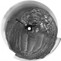
Nice! Here is an enlarged view, north at the top, a merge of five frames.
Phil
-------------------- ... because the Solar System ain't gonna map itself.
Also to be found posting similar content on https://mastodon.social/@PhilStooke Maps for download (free PD: https://upload.wikimedia.org/wikipedia/comm...Cartography.pdf NOTE: everything created by me which I post on UMSF is considered to be in the public domain (NOT CC, public domain) |
|
|
|
|
|
|
Jul 4 2017, 03:07 AM
Post
#70
|
||
|
Solar System Cartographer Group: Members Posts: 10193 Joined: 5-April 05 From: Canada Member No.: 227 |
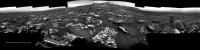
Jan's sol 1741 panorama in circular form. Compared with the last one (previous page) we are much closer to the prominent blocks.
Phil
-------------------- ... because the Solar System ain't gonna map itself.
Also to be found posting similar content on https://mastodon.social/@PhilStooke Maps for download (free PD: https://upload.wikimedia.org/wikipedia/comm...Cartography.pdf NOTE: everything created by me which I post on UMSF is considered to be in the public domain (NOT CC, public domain) |
|
|
|
|
|
|
Jul 4 2017, 08:15 AM
Post
#71
|
|
|
Member Group: Members Posts: 923 Joined: 10-November 15 Member No.: 7837 |
I refreshed my workflow for these simulated clips of Curiosity driving around HiRISE models mapped to mosaics...click thru for a video of Curi climbing Vera on Sol 1732.
 I'll take a look at the speed & suspension on the next one. -------------------- |
|
|
|
|
Jul 4 2017, 01:10 PM
Post
#72
|
||
|
Senior Member Group: Members Posts: 2430 Joined: 30-January 13 From: Penang, Malaysia. Member No.: 6853 |
A 4th of July Special from Curiosity, in the form of a long range 10 frame RMI mosaic featuring another section of the Vera Rubin Ridge. Rather nice for MS ICE, I'm hoping that rash statement will inspire others to have a go at this one
There is another 10 frame mosaic, but that will have to await my morrow. Happy 4th to all that are celebrating the original Brexit V1 (1776 version)
|
|
|
|
|
|
|
Jul 4 2017, 03:21 PM
Post
#73
|
|
 Senior Member Group: Members Posts: 1645 Joined: 5-March 05 From: Boulder, CO Member No.: 184 |
QUOTE (Sean @ Jul 4 2017, 08:15 AM) I refreshed my workflow for these simulated clips of Curiosity driving around HiRISE models mapped to mosaics...click thru for a video of Curi climbing Vera on Sol 1732. Interesting to see this Sean. Is Curiosity in your video climbing at a point SW of Northern Neck? I wonder what the slope is there (and traversing later beyond the field of view). My guess would be that a gentler climb is possible in the relative trough just to the east of Northern Neck, though still west of the notional route mentioned recently by Fernando. This would be after circling around the east side of the drifts. I suppose one could look at a slope map and figure out what path across the ridge has the lowest value of maximum up/down slope. This is what I had roughly done earlier by eye with your 3D interactive view. -------------------- Steve [ my home page and planetary maps page ]
|
|
|
|
|
Jul 4 2017, 04:05 PM
Post
#74
|
|
|
Member Group: Members Posts: 923 Joined: 10-November 15 Member No.: 7837 |
Yes Steve, you can see this on the model also...
Vera Rubin Ridge @Sketchfab  The planned route does offer what appears to be the best entry point to the Ridge, with the possible exit not far away to the south east. 
-------------------- |
|
|
|
|
Jul 5 2017, 08:45 AM
Post
#75
|
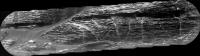
||
|
Senior Member Group: Members Posts: 2430 Joined: 30-January 13 From: Penang, Malaysia. Member No.: 6853 |
Drive to site 64/1890 on sol 1746, duration >50 minutes (MS-ICE with L-NavCam)
Not many frames yet, but this may help to identify the location
Edit: Several additional frames are down now (including a few of the top tier), but MS ICE can't cope with the sandy ripples (great pity). Midnight Planets reports the drive as ~22 meters East (100º) on Sol 1746. The direct path looks like an obstacle course, so they may head a little further East before going south? Whichever way they go, looks like there are no shortage of ground targets between the drives to the entry ramp
|
|
|
|
|
|
|
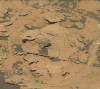
Jul 6 2017, 10:58 AM
Post
#76
|
||
|
Senior Member Group: Members Posts: 2430 Joined: 30-January 13 From: Penang, Malaysia. Member No.: 6853 |
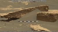
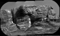
Sol 1745 R-MastCam (cropped mosaic) features one of several eroded blocks imaged by the mast camera. I've added a scale bar (50cm) below the block using AlgorimancerPG, the image has been sharpened a little.
There is a rather nice R-MastCam from the same sol, featuring an upper section of the Vera Rubin ridge, but it is bayer encoded and I can't do it justice after decoding (too many compression artifacts).
All 1745 MastCam images Link |
|
|
|
|
|
|
Jul 6 2017, 11:17 AM
Post
#77
|
|
|
Senior Member Group: Members Posts: 2430 Joined: 30-January 13 From: Penang, Malaysia. Member No.: 6853 |
|
|
|
|
|
Jul 6 2017, 11:46 PM
Post
#78
|
|
|
Member Group: Members Posts: 923 Joined: 10-November 15 Member No.: 7837 |
Here is another HiRISE enabled animation using Sol 1732 RGB mosaic mapped to Navcam composition. RGB gaps filled with data from Sols 1601, 1730, 1734 & extended sky
Click thru for the 4k version...  Click thru for the 2k version ( zoom cut in this sequence )...  MSL 1732 4k @Youtube MSL 1732 2k @Youtube This one has music & retimed to suit... 
-------------------- |
|
|
|
|
Jul 7 2017, 09:16 AM
Post
#79
|
|
|
Member Group: Members Posts: 816 Joined: 3-June 04 From: Brittany, France Member No.: 79 |
QUOTE (PaulH51 @ Jul 6 2017, 11:58 AM) There is a rather nice R-MastCam from the same sol, featuring an upper section of the Vera Rubin ridge, but it is bayer encoded and I can't do it justice after decoding (too many compression artifacts). Paul, I processed the bayer encoded MC100 pics of sol 1745  . Here is the mosaic: . Here is the mosaic: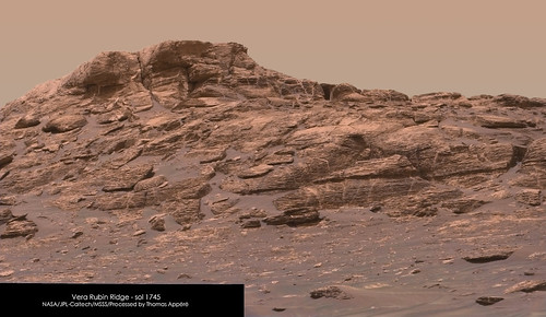 I also stitched the two RMI mosaics and placed them into context: 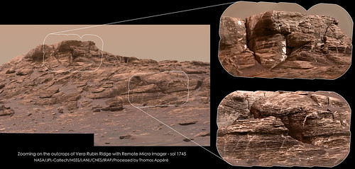
-------------------- |
|
|
|
|
Jul 8 2017, 01:58 AM
Post
#80
|
|
|
Senior Member Group: Members Posts: 2430 Joined: 30-January 13 From: Penang, Malaysia. Member No.: 6853 |
QUOTE (neo56 @ Jul 7 2017, 05:16 PM) Paul, I processed the bayer encoded MC100 pics of sol 1745 . Here is the mosaic:Thomas: Excellent de-bayering / treatment of the compression artifacts. Your panchromatic sharpening makes those RMI's come alive, great to see your work here once again Paul |
|
|
|
|
Jul 8 2017, 10:40 AM
Post
#81
|
||
|
Senior Member Group: Members Posts: 2430 Joined: 30-January 13 From: Penang, Malaysia. Member No.: 6853 |
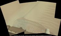
Sol 1748 : L-MastCam Workspace: Assembled in MS ICE, no additional processing, looks a little overexposed, but I've left the mosaic in its raw state (just stitched)
A 5-Sol plan has been issued Link 'Sol 1748-1752: Kicking Up Some Sand' I've tried to assemble the available NavCam frames for 1748, but they wont behave in MS ICE, which is a pity as the scene is rather special with the large sandy ripples...
|
|
|
|
|
|
|
Jul 8 2017, 12:20 PM
Post
#82
|
||
|
Senior Member Group: Members Posts: 2841 Joined: 22-April 05 From: Ridderkerk, Netherlands Member No.: 353 |
The Navcam L view on Sol 1746.
Jan van Driel
|
|
|
|
|
|
|
Jul 8 2017, 02:00 PM
Post
#83
|
||
|
Senior Member Group: Members Posts: 2841 Joined: 22-April 05 From: Ridderkerk, Netherlands Member No.: 353 |
and the view on Sol 1747.
Jan van Driel
|
|
|
|
|
|
|
Jul 9 2017, 07:23 PM
Post
#84
|
|||
|
Solar System Cartographer Group: Members Posts: 10193 Joined: 5-April 05 From: Canada Member No.: 227 |
Jan's last two panoramas in circular form.
Phil Sol 1746:
Sol 1747:
-------------------- ... because the Solar System ain't gonna map itself.
Also to be found posting similar content on https://mastodon.social/@PhilStooke Maps for download (free PD: https://upload.wikimedia.org/wikipedia/comm...Cartography.pdf NOTE: everything created by me which I post on UMSF is considered to be in the public domain (NOT CC, public domain) |
||
|
|
|
||
|
Jul 10 2017, 02:52 AM
Post
#85
|
||
|
Senior Member Group: Members Posts: 2430 Joined: 30-January 13 From: Penang, Malaysia. Member No.: 6853 |
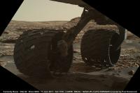
1749 MAHLI of the wheel scuff across the ripple, shows some interesting grain size distribution. Unprocessed other than adding the scale bar. Enhancing the colours shows some nice grain colour variations including one tiny and much redder grain than we are used to seeing, but I guess that may be a JPG compression artifact.
The scale bar is only applicable to items in sharp focus. Thumbnails suggest a focus stacked version was planned.
|
|
|
|
|
|
|
Jul 10 2017, 10:42 AM
Post
#86
|
||
|
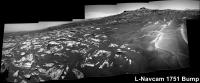
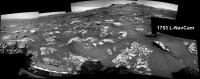
Senior Member Group: Members Posts: 2430 Joined: 30-January 13 From: Penang, Malaysia. Member No.: 6853 |
L-NavCam partial pan after a bump on 1751 roughly assembled in MS ICE
|
|
|
|
|
|
|
Jul 11 2017, 01:22 PM
Post
#87
|
|
|
Senior Member Group: Members Posts: 2430 Joined: 30-January 13 From: Penang, Malaysia. Member No.: 6853 |
I've seen the dates for the solar conjunction moratorium on commanding Opportunity (July 22 to Aug. 1, 2017) Link
Anyone here aware of the dates for MSL? Maybe I missed it
|
|
|
|
|
Jul 11 2017, 01:44 PM
Post
#88
|
|
|
Founder Group: Chairman Posts: 14433 Joined: 8-February 04 Member No.: 1 |
Last tactical shift is this Friday but I think the last drive will be Wednesday to allow us time to recover if something goes wrong with that drive, before conjunction starts.. First tactical shift afterwards is Monday Aug 7th, planning Sol 1780
I believe were expecting a BIG dump from MRO on the Friday before we start planning again. |
|
|
|
|
Jul 11 2017, 02:22 PM
Post
#89
|
|
|
Member Group: Admin Posts: 976 Joined: 29-September 06 From: Pasadena, CA - USA Member No.: 1200 |
QUOTE (PaulH51 @ Jul 11 2017, 05:22 AM) I've seen the dates for the solar conjunction moratorium on commanding Opportunity (July 22 to Aug. 1, 2017) Link Anyone here aware of the dates for MSL? Maybe I missed it Doug is right regarding MSL, but JPL is wrong with the dates for Oppy. Today is the last tactical shift for which we have a downlink before conjunction and July 18 is the last tactical shift with uplink before conjunction. We resume tactical on Aug 2. Paolo -------------------- Disclaimer: all opinions, ideas and information included here are my own,and should not be intended to represent opinion or policy of my employer.
|
|
|
|
|
Jul 11 2017, 06:52 PM
Post
#90
|
||
|
Solar System Cartographer Group: Members Posts: 10193 Joined: 5-April 05 From: Canada Member No.: 227 |
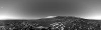
Sol 1752. These are Hazcams roughly reprojected to help me find the block we are looking at after the drive.
Phil
-------------------- ... because the Solar System ain't gonna map itself.
Also to be found posting similar content on https://mastodon.social/@PhilStooke Maps for download (free PD: https://upload.wikimedia.org/wikipedia/comm...Cartography.pdf NOTE: everything created by me which I post on UMSF is considered to be in the public domain (NOT CC, public domain) |
|
|
|
|
|
|
Jul 12 2017, 02:01 AM
Post
#91
|
||
|
Senior Member Group: Members Posts: 2430 Joined: 30-January 13 From: Penang, Malaysia. Member No.: 6853 |
Thanks guys for the info on the solar conjunction, but I know I'll have withdrawal symptoms during the image drought.
EDIT Here's an updated version of a long-distance RMI mosaic featuring a section of the Vera Rubin Ridge. Now with 10 overlapping frames assembled in MS-ICE
|
|
|
|
|
|
|
Jul 12 2017, 12:55 PM
Post
#92
|
|
|
Member Group: Members Posts: 923 Joined: 10-November 15 Member No.: 7837 |
Is the number of 'Drivecam' images a rough indicator of how far Curi has driven?
From 1752 measure of 10m it looks like 1753 is around 20m ( before metadata ) -------------------- |
|
|
|
|
Jul 12 2017, 01:11 PM
Post
#93
|
||
|
Senior Member Group: Members Posts: 2430 Joined: 30-January 13 From: Penang, Malaysia. Member No.: 6853 |
QUOTE (Sean @ Jul 12 2017, 08:55 PM) Is the number of 'Drivecam' images a rough indicator of how far Curi has driven? That's an interesting theory Sean:) We'll see later... Meanwhile... Roughly assembled partial 1753 L-NavCam in MS ICE
|
|
|
|
|
|
|
Jul 12 2017, 03:39 PM
Post
#94
|
|
|
Founder Group: Chairman Posts: 14433 Joined: 8-February 04 Member No.: 1 |
QUOTE (Sean @ Jul 12 2017, 04:55 AM) Is the number of 'Drivecam' images a rough indicator of how far Curi has driven? From 1752 measure of 10m it looks like 1753 is around 20m ( before metadata ) You mean the images with a SeqID of TRAV00NNN in them? They could sort of be used as an analogue for drive distance - but the step between them can vary |
|
|
|
|
Jul 12 2017, 05:15 PM
Post
#95
|
|
|
Member Group: Members Posts: 923 Joined: 10-November 15 Member No.: 7837 |
Thanks Doug.
-------------------- |
|
|
|
|
Jul 12 2017, 08:30 PM
Post
#96
|
||
|
Senior Member Group: Members Posts: 2841 Joined: 22-April 05 From: Ridderkerk, Netherlands Member No.: 353 |
The Navcam L view on Sol 1751.
Jan van Driel
|
|
|
|
|
|
|
Jul 12 2017, 09:01 PM
Post
#97
|
||
|
Solar System Cartographer Group: Members Posts: 10193 Joined: 5-April 05 From: Canada Member No.: 227 |
Thanks. Jan. Here it is in circular form.
Phil
-------------------- ... because the Solar System ain't gonna map itself.
Also to be found posting similar content on https://mastodon.social/@PhilStooke Maps for download (free PD: https://upload.wikimedia.org/wikipedia/comm...Cartography.pdf NOTE: everything created by me which I post on UMSF is considered to be in the public domain (NOT CC, public domain) |
|
|
|
|
|
|
Jul 13 2017, 08:35 PM
Post
#98
|
||
|
Senior Member Group: Members Posts: 2841 Joined: 22-April 05 From: Ridderkerk, Netherlands Member No.: 353 |
The Navcam L view on Sol 1752.
Jan van Driel
|
|
|
|
|
|
|
Jul 14 2017, 07:49 AM
Post
#99
|
|
|
Senior Member Group: Members Posts: 2430 Joined: 30-January 13 From: Penang, Malaysia. Member No.: 6853 |
Formal MSL conjunction dates:
Mission Update: Sol 1755: Getting Ready to Disappear Behind the Sun, by Roger Wiens, dated 13 July 2017 Link |
|
|
|
|
Jul 14 2017, 12:30 PM
Post
#100
|
||
|
Senior Member Group: Members Posts: 2841 Joined: 22-April 05 From: Ridderkerk, Netherlands Member No.: 353 |
The Navcam L view on Sol 1753.
Jan van Driel
|
|
|
|
|
|
|

|
Lo-Fi Version | Time is now: 15th June 2024 - 06:07 AM |
|
RULES AND GUIDELINES Please read the Forum Rules and Guidelines before posting. IMAGE COPYRIGHT |
OPINIONS AND MODERATION Opinions expressed on UnmannedSpaceflight.com are those of the individual posters and do not necessarily reflect the opinions of UnmannedSpaceflight.com or The Planetary Society. The all-volunteer UnmannedSpaceflight.com moderation team is wholly independent of The Planetary Society. The Planetary Society has no influence over decisions made by the UnmannedSpaceflight.com moderators. |
SUPPORT THE FORUM Unmannedspaceflight.com is funded by the Planetary Society. Please consider supporting our work and many other projects by donating to the Society or becoming a member. |
|