Home, Sweet Home, Dream becomes Reality |

  |
Home, Sweet Home, Dream becomes Reality |
 Feb 5 2006, 06:46 PM Feb 5 2006, 06:46 PM
Post
#1
|
|
 Senior Member  Group: Members Posts: 1229 Joined: 24-December 05 From: The blue one in between the yellow and red ones. Member No.: 618 |
Hope no one minds, but I felt we have to have a new topic, right from the start, as a compendium of all the Factual Observations on this incredible structure...this Mother Ship from another world...this...(who said Burgess Shale? I laughed at that at the time.
 ) Who will start us off with a detailed description of what we see before us TODAY February 5, 2006 - Super Sunday. ) Who will start us off with a detailed description of what we see before us TODAY February 5, 2006 - Super Sunday.(I'll be running from game to Exploratorium all afternoon! 
-------------------- My Grandpa goes to Mars every day and all I get are these lousy T-shirts!
|
 |
 
|
|
Feb 5 2006, 09:44 PM
Post
#2
|
||
|
Senior Member Group: Members Posts: 1229 Joined: 24-December 05 From: The blue one in between the yellow and red ones. Member No.: 618 |
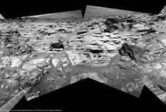
O.K. We're there, and we might as well start at the bottom and work up.
I've cropped an area of slabs at the base of the section and assigned working names so we can easily refer to them. So, can some of the field geologists give the non-geos among us a description of the types they see and list things they could be?
For example, to my untutored eye, the rocks El over to Ward represent a group of similar layers. Are they different in some significant way from the slabs Darby and Bernard just above? Is the upper layer likely to be of different origin or makeup? Obviously we don't have spectrometry now, so this is a visual-only exercise. Have we seen anything even remotely related to HP in Gusev so far? C'mon, rockhounds! We're all ears!  P.S. Steelers by 3 -------------------- My Grandpa goes to Mars every day and all I get are these lousy T-shirts!
|
|
|
|
|
|
|
Feb 6 2006, 07:02 PM
Post
#3
|
|
|
Member Group: Members Posts: 252 Joined: 27-April 05 Member No.: 365 |
Ok, the 'Going to Home Plate' thread is getting a bit long for me, so I thought I start a new topic now that we are 'there'.
I'm thinking that the MER team may already be contemplating ways to either ride out winter at HP/PM or how to at least extend their stay further into winter (perhaps 'Island hopping' thru north-facing slopes between HP and McCool Hill when they do leave). If they decide to stay, they might do the top of HP early on, then more of the north-facing perimeter deeper in the winter, then hop around to the north side of PM? |
|
|
|
|
Feb 6 2006, 07:12 PM
Post
#4
|
|
 Member Group: Members Posts: 723 Joined: 13-June 04 Member No.: 82 |
|
|
|
|
|
Feb 6 2006, 07:14 PM
Post
#5
|
|
|
Member Group: Members Posts: 252 Joined: 27-April 05 Member No.: 365 |
Oops, sorry, didn't spot that one!
|
|
|
|
|
Feb 6 2006, 07:15 PM
Post
#6
|
|
 Senior Member Group: Moderator Posts: 3431 Joined: 11-August 04 From: USA Member No.: 98 |
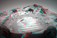
Check out the view out "to sea", as it were, from our position next to Home Plate. Yes, I know, I shouldn't say "out to sea" because the Martian Tricorder crowd will take me seriously, but I just can't help myself, the view is so evocative of a bay or something
 The view is due West by the way, 90 degrees wide. The view is due West by the way, 90 degrees wide.Edit: Oops, I guess we should go with the other thread, although I like the title of this one better. |
|
|
|
|
Feb 6 2006, 07:25 PM
Post
#7
|
|
|
Member Group: Members Posts: 252 Joined: 27-April 05 Member No.: 365 |
And the atmosphere is clearing a bit, I think!
|
|
|
|
|
Feb 6 2006, 07:44 PM
Post
#8
|
|
|
Member Group: Members Posts: 242 Joined: 21-December 04 Member No.: 127 |
The granular lower level intrigues me. Could be an ashfall layer, or we could be seeing grain size differences based on water velocity.
To go way, way out on a limb, there seems to be some periodicity within the coarse layer. Perhaps a series of flooding events? Above it is the finer-grained material...perhaps lacrustine sediments overlaying the initial coarse material following the water filling the basin? |
|
|
|
|
Feb 6 2006, 08:34 PM
Post
#9
|
|
|
Senior Member Group: Members Posts: 1229 Joined: 24-December 05 From: The blue one in between the yellow and red ones. Member No.: 618 |
QUOTE (gpurcell @ Feb 6 2006, 09:44 AM) The granular lower level intrigues me. Could be an ashfall layer, or we could be seeing grain size differences based on water velocity. To go way, way out on a limb, there seems to be some periodicity within the coarse layer. Perhaps a series of flooding events? Above it is the finer-grained material...perhaps lacrustine sediments overlaying the initial coarse material following the water filling the basin?  Thanx. I assume the entire Steelers backfield (sorry about the mixing of sports - Is this, by the way, the outcrop dubbed Gibson ?), is float that has fallen from above, so the El - Ward line is the base of this section. From this distance (When is Explo./JPL going to release today's photos??) the granular layer seems to have shadowed interstices (sorry I don't speak good Geo ). Would that favor a 'scoriaceous' kind of ashfall over a lacustrine gravel bed? Can we put any time constraints on this section? Is it less than a million years of accumulation, or given the nature of Mars could it be almost any duration? (Insert emoticon for sitting-at-your-feet-with-rapt-attention) -------------------- My Grandpa goes to Mars every day and all I get are these lousy T-shirts!
|
|
|
|
|
Feb 6 2006, 09:15 PM
Post
#10
|
|
|
Senior Member Group: Members Posts: 2998 Joined: 30-October 04 Member No.: 105 |
Just off the top of my head: the reason Spirit needs to be on a north-facing slope in Winter is that the Sun moves into the northern sky and the solar panels need to be tilted northward to keep them aligned with the Sun. FWIW, at 14 degrees south latitude the Sun will be no higher than 53* above the northern horizon.
But since the Sun moves NorthEast to due North to NorthWest, it the panels need to be oriented NE in the morning, N at noon and NW in the afternoon, so it seems that it could add a northwest-biased tilt in the afternoon for optimum solar output. That NW slope would be easily obtainable on the NW slope of McCool Hill, which could expand the envelope of possible paths. It will be interesting to see how the mission planners do this Winter. --Bill -------------------- |
|
|
|
|
Feb 6 2006, 09:21 PM
Post
#11
|
||
 Senior Member Group: Members Posts: 1089 Joined: 19-February 05 From: Close to Meudon Observatory in France Member No.: 172 |
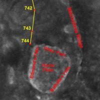
I hope we will have some time also to climb on top of Home Plate. Here are the names I gave to its 3 major albedo structures seen from orbit : a tribute much deserved to the 3 Home Plate discoverers : Dr. Nathalie Cabrol and Dr. Edmond Grin, not forgetting Gilles Dawidowicz, their intern student, who pintpointed Home Plate's interest from the very beginning ! Links : http://www.unmannedspaceflight.com/index.p...indpost&p=38492 http://www.unmannedspaceflight.com/index.p...indpost&p=38541
Attached thumbnail(s)
|
|
|
|
|
|
|
Feb 6 2006, 10:46 PM
Post
#12
|
|
|
Member Group: Members Posts: 713 Joined: 30-March 05 Member No.: 223 |
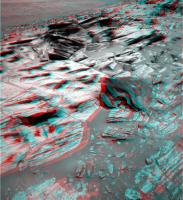
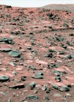
hand-colorized Sol 744 "Home Plate" panorama and Sol 743 navcam "El-Dorado Looking Back" Navcam-Panorama:
  (as always, those colors only reflect my subjective vision of the otherwise b/w landscape and may be way off the "true" spectrum ... 
|
|
|
|
|
Feb 6 2006, 11:04 PM
Post
#13
|
|
|
Member Group: Members Posts: 548 Joined: 19-March 05 From: Princeton, NJ, USA Member No.: 212 |
QUOTE (Nirgal @ Feb 6 2006, 10:46 PM) hand-colorized Sol 744 "Home Plate" panorama and Sol 743 navcam "El-Dorado Looking Back" Navcam-Panorama: Bernhard, these are fantastic and puts it all in perspective that HP has suffered an extremely violent event(s). And the layering on the right will I hope be an early target before climbing up as well as the richly layered areas and tire like tracks towards the left. this is a dream come true for all. Not surprisingly, SS sure was fast this time with an update ken |
|
|
|
|
Feb 6 2006, 11:16 PM
Post
#14
|
|
|
Member Group: Members Posts: 548 Joined: 19-March 05 From: Princeton, NJ, USA Member No.: 212 |
QUOTE (vikingmars @ Feb 6 2006, 09:21 PM) I hope we will have some time also to climb on top of Home Plate.Here are the names I gave to its 3 major albedo structures seen from orbit : a tribute much deserved to the 3 Home Plate discoverers : Dr. Nathalie Cabrol and Dr. Edmond Grin, not forgetting Gilles Dawidowicz, their intern student, who pintpointed Home Plate's interest from the very beginning ! Links : Olivier yeah I cant imagine the MER team not climbing on top unless there is no safe path and thanks for the backgroud on HP discoverers. I had missed that earlier and just checked out those illuminating presentations ken |
|
|
|
|
Feb 6 2006, 11:17 PM
Post
#15
|
|
 Member Group: Members Posts: 267 Joined: 5-February 06 Member No.: 675 |
QUOTE (mars loon @ Feb 6 2006, 11:04 PM) Bernhard, these are fantastic and puts it all in perspective that HP has suffered an extremely violent event(s).... ken Ken, The shards of shattered rock need not indicate extremely violent event(s). They look just like the kind of fragments one finds at the foot of mesas in Northern Arizona. The (admittedly uniformitarian) consensus is that those are the result of slow processes in which pieces of rock broke off, fell, shattered, and tumbled down the slope. I suspect similar processes took place at Home Plate. Steve |
|
|
|
|
Feb 7 2006, 01:40 AM
Post
#16
|
|
|
Senior Member Group: Members Posts: 1636 Joined: 9-May 05 From: Lima, Peru Member No.: 385 |
I look forward in hearing from JPL's activity plan around HP. Will Spirit circle around it before climbing into HP. I think that the most important step at HP is to circle around it due two strong reasons:
1) A scientific method that starts from outside into inside. This method help to understand better the nature of HP first by visting the outside that might influence it. 2) Now it is spring, there is more light now than tomorrow, so Spirit must take the advantage of it in the early to spend more solar energy to circle around HP before climbing into HP. 3) You name it if you have a good guess about the next Spirit move !!! Rodolfo |
|
|
|
| Guest_Sunspot_* |
Feb 7 2006, 01:52 AM
Post
#17
|
|
Guests |
They need to put the MI on the rock in the top left of this image
http://marsrovers.jpl.nasa.gov/gallery/all...0P2363R1M1.HTML |
|
|
|
|
Feb 7 2006, 01:55 AM
Post
#18
|
|
|
Senior Member Group: Members Posts: 2998 Joined: 30-October 04 Member No.: 105 |
QUOTE The shards of shattered rock need not indicate extremely violent event(s). They look just like the kind of fragments one finds... The fragments look like the rock was formed by cyclic deposition events, and have a shattered appearance because of extreme diurnal thermal cycling. I'm interested in seeing the "basement' unit below this layered unit. I imagine that an impact ought to show shattercones (or other signs). This looks like a weathered outcrop. --Bill -------------------- |
|
|
|
|
Feb 7 2006, 01:58 AM
Post
#19
|
|
|
Senior Member Group: Members Posts: 1636 Joined: 9-May 05 From: Lima, Peru Member No.: 385 |
QUOTE (Sunspot @ Feb 6 2006, 08:52 PM) They need to put the MI on the rock in the top left of this image http://marsrovers.jpl.nasa.gov/gallery/all...0P2363R1M1.HTML Do MI on the laminated fallen rock? It looks it was detached from the rim of HP and later it was eroded by the aeolian process, does it not? Rodolfo |
|
|
|
| Guest_Sunspot_* |
Feb 7 2006, 02:05 AM
Post
#20
|
|
Guests |
Yep...thats the one. Also Spirit would be in a great spot for some closeup pancams of the rest of the layered outcrop.
|
|
|
|
|
Feb 7 2006, 02:56 AM
Post
#21
|
|
|
Senior Member Group: Members Posts: 1229 Joined: 24-December 05 From: The blue one in between the yellow and red ones. Member No.: 618 |
QUOTE (Sunspot @ Feb 6 2006, 04:05 PM) Yep...thats the one. Also Spirit would be in a great spot for some closeup pancams of the rest of the layered outcrop. Abso-freakin'-lutely! So where are today's photos at Exploratorium? Don't they know we're dyin' out here waiting for some close-ups? I've been at this keyboard so long I see 164 keys! What's going on? We're hooked now; they can't cut us off cold turkey!  (I don't know what this emoticon means, but it's indicative of my mental state.) (I don't know what this emoticon means, but it's indicative of my mental state.)
-------------------- My Grandpa goes to Mars every day and all I get are these lousy T-shirts!
|
|
|
|
|
Feb 7 2006, 02:59 AM
Post
#22
|
|
|
Junior Member Group: Members Posts: 83 Joined: 19-April 05 Member No.: 251 |
QUOTE (Sunspot @ Feb 6 2006, 08:52 PM) They need to put the MI on the rock in the top left of this image http://marsrovers.jpl.nasa.gov/gallery/all...0P2363R1M1.HTML You mean the piece of broken pottery? |
|
|
|
|
Feb 7 2006, 03:00 AM
Post
#23
|
|
 Member Group: Members Posts: 753 Joined: 23-October 04 From: Greensboro, NC USA Member No.: 103 |
That "laminated fallen rock" almost looks like a shard of pottery in an archaeological dig.
-------------------- Jonathan Ward
Manning the LCC at http://www.apollolaunchcontrol.com |
|
|
|
|
Feb 7 2006, 03:22 AM
Post
#24
|
|
|
Senior Member Group: Members Posts: 1229 Joined: 24-December 05 From: The blue one in between the yellow and red ones. Member No.: 618 |
QUOTE (Bill Harris @ Feb 6 2006, 03:55 PM) The fragments look like the rock was formed by cyclic deposition events, and have a shattered appearance because of extreme diurnal thermal cycling. I'm interested in seeing the "basement' unit below this layered unit. I imagine that an impact ought to show shattercones (or other signs). This looks like a weathered outcrop. --Bill Yes, definitely. I don't see it on this side. I think we must get a look at the west side. -------------------- My Grandpa goes to Mars every day and all I get are these lousy T-shirts!
|
|
|
|
|
Feb 7 2006, 03:25 AM
Post
#25
|
|
|
Senior Member Group: Members Posts: 1229 Joined: 24-December 05 From: The blue one in between the yellow and red ones. Member No.: 618 |
QUOTE (ddeerrff @ Feb 6 2006, 04:59 PM) You mean the piece of broken pottery? No, he means the old porcelein commode. ...gasp....getting delirious...must rest soon...rest...yeeeesss -------------------- My Grandpa goes to Mars every day and all I get are these lousy T-shirts!
|
|
|
|
| Guest_Richard Trigaux_* |
Feb 7 2006, 08:29 AM
Post
#26
|
|
Guests |
Hi all,
there was recently another thread Home Plate Speculations, Get it in now, before we know the truth! with a friendly competition about trying to understand Homeplate before we actually see and analyse it. It seems that I was a bit close to what we see: (predicting a three-layered system) QUOTE (Richard Trigaux @ Feb 5 2006, 11:19 AM) The latest scenario I suggest, after closest view of sol 742: Sometimes between the formation of Gussev and the final filling by mudflow, there was a lake (temporary, or permanent). The surface of this lake was about the level of Homeplate, or a little above, so that Husband hills were not covered. Its open surface lasted only some days, and after the surface frozen, and eventually all the water froze to the core in some months or years. This water was charged with a variety of salts, and these salts were deposited, but very unevenly, from the presence of ice, after one or several of the following processes: -waves projected water on mounds, where it evaporated very quickly, lefting the salts on priviledged patches. (This is sometimes visible on earth) -there were faults in the ice cover, allowing strong evaporation of water in some very restricted places. -There was a continuous ice cover, see the lake froze into its whole depth. But salts were contentred in tiny patches of very salty brines, which can exist at very low temperatures (-50°C for calcium chloride). When ice sublimated, it left the solid salt patches to end drying. Homeplate could be one of these patches. Other were observed all around. So if this model is true, it predicts that Homeplate and similar smaller patches are just salts. Eventually we may find, from top to bottom: -basaltic blocks and sands, projected here by more recent impacts -most soluble salts, such as sodium and calcium chlorides -less soluble salts, such as jarosite and sulphates -eventually an iron oxyd layer somewhere in between -at bottom a sandstone of basaltic sand cemented with sulphates or carbonates (eventually limestone). This layer would be the dark rocky outcrop which seems to encircle Homeplate. -a "discordance" and under ordinary soil (same as elsewhere around). ... and that Homeplate would be the same thing than a much larger similar structure, that of Pollack crater |
|
|
|
|
Feb 7 2006, 10:12 AM
Post
#27
|
|
|
Senior Member Group: Members Posts: 2998 Joined: 30-October 04 Member No.: 105 |
Richard--
I'm witholding judgement until we know more about the lithologies... --Bill -------------------- |
|
|
|
|
Feb 7 2006, 03:43 PM
Post
#28
|
|
|
Member Group: Members Posts: 252 Joined: 27-April 05 Member No.: 365 |
Does this image show Bonneville in the upper left?
http://qt.exploratorium.edu/mars/spirit/na...00P1785L0M1.JPG If so, it is a very nice view of the route between Bonneville and West Spur. |
|
|
|
|
Feb 7 2006, 04:05 PM
Post
#29
|
|
 Member Group: Members Posts: 531 Joined: 24-August 05 Member No.: 471 |
I mean no, Bonneville is rather behind the rocky hill in the upper right. The crater (upper left) is exactly to the west.
-------------------- - blue_scape / Nico -
|
|
|
|
|
Feb 7 2006, 04:08 PM
Post
#30
|
|
 Senior Member Group: Admin Posts: 4763 Joined: 15-March 05 From: Glendale, AZ Member No.: 197 |
QUOTE (mhoward @ Feb 6 2006, 07:15 PM) although I like the title of this one better. Ditto.
-------------------- If Occam had heard my theory, things would be very different now.
|
|
|
|
|
Feb 7 2006, 08:00 PM
Post
#31
|
|
|
Member Group: Members Posts: 252 Joined: 27-April 05 Member No.: 365 |
A run, a short followup bump, set the wheels, and they are clearly in position to do IDD work (assuming the wheels are stable now). Talk about precision driving!
http://qt.exploratorium.edu/mars/spirit/fo...38P1201L0M1.JPG http://qt.exploratorium.edu/mars/spirit/fo...55P1214L0M1.JPG Do you want your laminations thick or thin? http://qt.exploratorium.edu/mars/spirit/na...55P0685L0M1.JPG |
|
|
|
|
Feb 7 2006, 08:03 PM
Post
#32
|
|
|
Senior Member Group: Members Posts: 2998 Joined: 30-October 04 Member No.: 105 |
I just regained my power of speech and I'm again speechless. The view is great, and that was some fancy driving.
I'll take my laminations any way I can get them... --Bill -------------------- |
|
|
|
|
Feb 7 2006, 08:05 PM
Post
#33
|
|
|
Member Group: Members Posts: 163 Joined: 16-March 05 From: Oakville, Ontario, Canada Member No.: 201 |
QUOTE (Burmese @ Feb 7 2006, 08:00 PM) Is it me or does it look nice and smooth up top? thought it would be "bumpier"..easy riding when they get up top to scoot around to other outcrops on HP once they leave the "wall"..which probably won't be for a while.. |
|
|
|
|
Feb 7 2006, 08:07 PM
Post
#34
|
|
|
Senior Member Group: Moderator Posts: 3431 Joined: 11-August 04 From: USA Member No.: 98 |
This is the view looking 45 degrees down directly in front of Spirit:
 So as near as I can tell, we must be parked at about a 45 degree angle. Really amazing driving. Edit: Okay, maybe more like 30 or 35. Unbelievable. Edit: Also near as I can tell, we are facing approximately southeast So the solar panels are pointed roughly northwest. |
|
|
|
|
Feb 7 2006, 08:11 PM
Post
#35
|
|
 Member Group: Members Posts: 510 Joined: 17-March 05 From: Southeast Michigan Member No.: 209 |
...best parking job I've seen since Elwood swung the Bluesmobile into that spot outside of Chez Paul.
-------------------- --O'Dave
|
|
|
|
|
Feb 7 2006, 08:13 PM
Post
#36
|
|
|
Member Group: Members Posts: 877 Joined: 7-March 05 From: Switzerland Member No.: 186 |
The last pictures show so many layers in the Plate - that wasn't an impact event, was it.
If it was not a single event that caused the layers then I would think Home Plate is the rest of a filled crater as "the other" Doug has mentioned earlier - or maybe a filled little extinct volcano. That scenario would open a very big book of ancient time - like a tree trunk. -------------------- |
|
|
|
|
Feb 7 2006, 08:20 PM
Post
#37
|
||
 Senior Member Group: Members Posts: 2492 Joined: 15-January 05 From: center Italy Member No.: 150 |
Really sweet!
It seems drivers are very, very aggressive: almost 30deg inclination from sideview! They are climbing to the top, apparently (you can see the plateau now)...
Attached thumbnail(s)
-------------------- I always think before posting! - Marco -
|
|
|
|
|
|
|
Feb 7 2006, 08:25 PM
Post
#38
|
|
|
Senior Member Group: Moderator Posts: 3431 Joined: 11-August 04 From: USA Member No.: 98 |
Here's a wide view and a "top" view.
|
|
|
|
|
Feb 7 2006, 08:35 PM
Post
#39
|
|
|
Senior Member Group: Members Posts: 1229 Joined: 24-December 05 From: The blue one in between the yellow and red ones. Member No.: 618 |
QUOTE (dilo @ Feb 7 2006, 10:20 AM) Really sweet! It seems drivers are very, very aggressive: almost 30deg inclination from sideview! They are climbing to the top, apparently (you can see the plateau now)...  Is that possible here, Dilo? What angle of slope is this face? Is that possible here, Dilo? What angle of slope is this face?
-------------------- My Grandpa goes to Mars every day and all I get are these lousy T-shirts!
|
|
|
|
|
Feb 7 2006, 08:39 PM
Post
#40
|
||
|
Senior Member Group: Members Posts: 2837 Joined: 22-April 05 From: Ridderkerk, Netherlands Member No.: 353 |
Here is the view of Homeplate on Sol 744.
Taken with the R0 navcam. jvandriel
Attached thumbnail(s)
|
|
|
|
|
|
|
Feb 7 2006, 08:40 PM
Post
#41
|
||
|
Senior Member Group: Members Posts: 2837 Joined: 22-April 05 From: Ridderkerk, Netherlands Member No.: 353 |
and here Spirit looking back on Sol 745.
Taken with the L0 navcam. jvandriel
Attached thumbnail(s)
|
|
|
|
|
|
|
Feb 7 2006, 08:41 PM
Post
#42
|
|
|
Senior Member Group: Moderator Posts: 3431 Joined: 11-August 04 From: USA Member No.: 98 |
Good grief - imagine what the Pancams will look like.
|
|
|
|
|
Feb 7 2006, 08:46 PM
Post
#43
|
|
|
Member Group: Members Posts: 713 Joined: 30-March 05 Member No.: 223 |
QUOTE (mhoward @ Feb 7 2006, 10:41 PM) Good grief - imagine what the Pancams will look like. latest L7-pancam (synthetic colors) 
|
|
|
|
|
Feb 7 2006, 08:54 PM
Post
#44
|
||
|
Senior Member Group: Members Posts: 2492 Joined: 15-January 05 From: center Italy Member No.: 150 |
QUOTE (Shaka @ Feb 7 2006, 08:35 PM) Is that possible here, Dilo? What angle of slope is this face?Look at this if you don't believe me! And this is the straightened side view:
Attached thumbnail(s)
-------------------- I always think before posting! - Marco -
|
|
|
|
|
|
|
Feb 7 2006, 08:54 PM
Post
#45
|
|
|
Senior Member Group: Moderator Posts: 3431 Joined: 11-August 04 From: USA Member No.: 98 |
Nice, Nirgal! Fast work, too; I'm pretty sure those frame just came down within the last couple hours.
Boy, AutoStitch gets the jaggies with those heavily tilted frames as bad as MMB does. Funny. |
|
|
|
|
Feb 7 2006, 08:55 PM
Post
#46
|
|
|
Founder Group: Chairman Posts: 14433 Joined: 8-February 04 Member No.: 1 |
They wont climb to the top here ( infact, they'd have no chance ) - but they're in a 'Hillary' type position- parked up a bit of a slope probably as far as the rover will go - wheel wiggle to settle it - and IDD away
Doug |
|
|
|
| Guest_Richard Trigaux_* |
Feb 7 2006, 08:56 PM
Post
#47
|
|
Guests |
QUOTE (Bill Harris @ Feb 7 2006, 10:12 AM) Richard-- I'm witholding judgement until we know more about the lithologies... --Bill You are right |
|
|
|
|
Feb 7 2006, 09:01 PM
Post
#48
|
|
|
Member Group: Members Posts: 147 Joined: 30-June 05 From: Bristol, UK Member No.: 423 |
Looks like a good angle to catch some rays and recharge! - Ahhhhh!
A little reminiscent of burns cliff. Nice work! Nick |
|
|
|
|
Feb 7 2006, 09:04 PM
Post
#49
|
||
|
Senior Member Group: Members Posts: 2837 Joined: 22-April 05 From: Ridderkerk, Netherlands Member No.: 353 |
Here is the view from Sol 744 into the drive direction.
Taken with the L7 pancam. jvandriel
Attached thumbnail(s)
|
|
|
|
|
|
| Guest_Richard Trigaux_* |
Feb 7 2006, 09:09 PM
Post
#50
|
|
Guests |
QUOTE (dilo @ Feb 7 2006, 08:54 PM) If you notice a strange thing, which is visible on le big dark loose rock on the left, and also on other places more to the left: it is as if spherical volumes of strata were missing. Even if you look well at the left, a spherical volume is missing, and the strata are folded, as if they had formed around a spherical object. I am not sure, but it looks that these layers contained something like giant blueberries, but which are no more in place today, because they were eliminated by erosion or something else. |
|
|
|
|
Feb 7 2006, 09:14 PM
Post
#51
|
|
|
Member Group: Members Posts: 531 Joined: 24-August 05 Member No.: 471 |
Here's a new rover view ...
Today's (Sol 746) Spirit (506 KB): 
-------------------- - blue_scape / Nico -
|
|
|
|
|
Feb 7 2006, 09:19 PM
Post
#52
|
|
|
Member Group: Members Posts: 252 Joined: 27-April 05 Member No.: 365 |
http://qt.exploratorium.edu/mars/spirit/na...55P1926L0M1.JPG
Are we looking at the bottom of this layered caprock, or is it simply diving down below the surface? |
|
|
|
| Guest_Richard Trigaux_* |
Feb 7 2006, 09:23 PM
Post
#53
|
|
Guests |
I must say that there is a tremendous work made to present readable images from raw data!!! Hi all!!
|
|
|
|
|
Feb 7 2006, 09:24 PM
Post
#54
|
|
|
Founder Group: Chairman Posts: 14433 Joined: 8-February 04 Member No.: 1 |
two threads merged
|
|
|
|
|
Feb 7 2006, 09:39 PM
Post
#55
|
||
|
Senior Member Group: Members Posts: 2492 Joined: 15-January 05 From: center Italy Member No.: 150 |
QUOTE (SigurRosFan @ Feb 7 2006, 09:14 PM) Here's a new rover view ... Today's (Sol 746) Spirit (506 KB): Wow Doug! I was preparing this sequence in order to identify HP features, but you did better!
(Sol 743-744-746 from top to bottom) -------------------- I always think before posting! - Marco -
|
|
|
|
|
|
|
Feb 7 2006, 11:12 PM
Post
#56
|
|
|
Member Group: Members Posts: 548 Joined: 19-March 05 From: Princeton, NJ, USA Member No.: 212 |
Are there estimates on how high is HP above the surrounding terrain? 15 - 20 ft , 5-7 m?
and info on when they may plan a drive around to check for a safe path to climb up? |
|
|
|
|
Feb 7 2006, 11:18 PM
Post
#57
|
|
|
Senior Member Group: Members Posts: 2998 Joined: 30-October 04 Member No.: 105 |
QUOTE Are we looking at the bottom of this layered caprock, or is it simply diving down below the surface? I don't know what the structure is here. From the image that Burmese pointed at, it does look that the layers are dipping towards the interior of Homeplate. It looks that the caprock at Pitchers Mound is dipping towards HP. Dipping at 20 or so degrees. I'd expect essentially flat-lying or gently dipping. We need to get to the other side of HP and look, and look at PM. --Bill 2N192598580EFFAO55P1926L0M1 -------------------- |
|
|
|
|
Feb 7 2006, 11:29 PM
Post
#58
|
||
|
Senior Member Group: Members Posts: 1229 Joined: 24-December 05 From: The blue one in between the yellow and red ones. Member No.: 618 |
QUOTE (Nirgal @ Feb 7 2006, 10:46 AM) latest L7-pancam (synthetic colors) Ah, the Operating Theater ! Very fine, Dr. Nirgal! Now, Doctors, where shall we make the First Incision ? How about:
Rats, no Rat! Where shall we make the First Abrasion ? Other suggestions? -------------------- My Grandpa goes to Mars every day and all I get are these lousy T-shirts!
|
|
|
|
|
|
|
Feb 7 2006, 11:30 PM
Post
#59
|
|
|
Senior Member Group: Members Posts: 2492 Joined: 15-January 05 From: center Italy Member No.: 150 |
QUOTE (mars loon @ Feb 7 2006, 11:12 PM) Are there estimates on how high is HP above the surrounding terrain? 15 - 20 ft , 5-7 m? Much less than this, Ken. If you consider that Spirit NavCam is able to see the plateau surface while standing at only 1/3 of the total wall height, elevation should be slightly above 2 meters in the rightmost (North-West) side and, perhaps, less than 1m in the East side... look also to the simulated Doug's view, few posts above... -------------------- I always think before posting! - Marco -
|
|
|
|
|
Feb 8 2006, 04:45 AM
Post
#60
|
|
|
Member Group: Members Posts: 139 Joined: 14-October 05 From: Toronto, Canada Member No.: 529 |
QUOTE (Richard Trigaux @ Feb 7 2006, 05:09 PM) If you notice a strange thing, which is visible on le big dark loose rock on the left, and also on other places more to the left: it is as if spherical volumes of strata were missing. Even if you look well at the left, a spherical volume is missing, and the strata are folded, as if they had formed around a spherical object. I am not sure, but it looks that these layers contained something like giant blueberries, but which are no more in place today, because they were eliminated by erosion or something else. Could these voids not be cause by aeolian errosion sandblasting out a void? I've seen something similiar in the rocks around Colorado Springs. -------------------- -- Robin
|
|
|
|
|
Feb 8 2006, 07:58 AM
Post
#61
|
||
 Member Group: Members Posts: 362 Joined: 12-June 05 From: Kiama, Australia Member No.: 409 |
Wow!!
Attached thumbnail(s)
|
|
|
|
|
|
|
Feb 8 2006, 08:17 AM
Post
#62
|
|
|
Founder Group: Chairman Posts: 14433 Joined: 8-February 04 Member No.: 1 |
QUOTE (Shaka @ Feb 7 2006, 11:29 PM) Rats, no Rat! Where shall we make the First Abrasion ? Other suggestions? The Rat's ability to grind has been lost for months - it's worn out. They can brush, but not grind. Doug |
|
|
|
|
Feb 8 2006, 09:22 AM
Post
#63
|
||
|
Senior Member Group: Moderator Posts: 4279 Joined: 19-April 05 From: .br at .es Member No.: 253 |
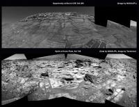
A combination of two panoramas.
Oppy at Home Plate on top, and Spirit at Burns Cliff at ... no, wait a minute! Oppy at Burns Cliff at the bottom and Spirit at... wrong again! Man, they are so similar. Well, judge by yourself.
|
|
|
|
|
|
|
Feb 8 2006, 09:32 AM
Post
#64
|
|
 Senior Member Group: Members Posts: 2488 Joined: 17-April 05 From: Glasgow, Scotland, UK Member No.: 239 |
QUOTE (abalone @ Feb 8 2006, 08:58 AM) Wow!! Indeedy! Firstly, look beyond the immediate eye-candy - HP *is* a bowl, we're looking across the top surface in the background and it clearly has a 'crater' shape (as in bowl, no more). Secondly, I agree that the form of the exposed surfaces is, as previously said, all about the tricks of aeolian erosion - you get some very strange shapes, and they don't need to mean much except the way the winds blow. Thirdly, the fine stratification has to mean persistent episodes of "something". Dykes don't do that, ashfall seems less likely to me now, water more so, but... ...mud pseudo-vulcanism? And finally: I know it can't be, but... ...lithographic slate? Anybody seen any Archeopteryx? Answers, on a postcard please, to Mr R Hoaxland... Bob Shaw -------------------- Remember: Time Flies like the wind - but Fruit Flies like bananas!
|
|
|
|
|
Feb 8 2006, 10:28 AM
Post
#65
|
||
|
Member Group: Members Posts: 362 Joined: 12-June 05 From: Kiama, Australia Member No.: 409 |
Hazcam view
Attached thumbnail(s)
|
|
|
|
|
|
|
Feb 8 2006, 11:25 AM
Post
#66
|
|
|
Senior Member Group: Members Posts: 2998 Joined: 30-October 04 Member No.: 105 |
QUOTE Oppy at Home Plate on top, and Spirit at Burns Cliff at ... no, wait a minute! Oppy at Burns Cliff at the bottom and Spirit at... wrong again! Man, they are so similar. I dunno where we are! However, it does suggest the effects of similar aeolian erosion on rocks of similar mechanical properties. Google "loess". There is a wealth of information on it and it may apply here *only in the context of a windblown deposit*. --Bill -------------------- |
|
|
|
|
Feb 8 2006, 11:30 AM
Post
#67
|
|
|
Founder Group: Chairman Posts: 14433 Joined: 8-February 04 Member No.: 1 |
It does strongly remind me of Burns Cliff - the middle parts that are suggested as being depositied by wind, and then being altered by water. Who knows. Why is it here? What IS Home Plate, what's that stuff made of, ahhhhh---it's all too much
Big MI sequence tosol it seems, Spirits IDD will get a work out today. CODE Sol Seq.Ver ETH ESF EDN EFF ERP Tot Description --- -------- --- --- --- --- --- ---- ----------- 747 p1110.03 2 0 0 2 0 4 front_haz_idd_mi_doc_1024x1024x1bpp_pri_56 747 p1131.05 2 0 2 0 0 4 front_haz_idd_mb_doc_512x512x1_bpp_high 747 p1206.05 2 0 0 2 0 4 front_hazcam_half_bpp_pri_20 747 p1214.05 2 0 0 2 0 4 front_hazcam_ultimate_4_bpp 747 p1244.00 2 2 0 0 0 4 front_hazcam_wheel_sub_256x256_4_bpp_pri_16 747 p1344.00 3 3 0 0 0 6 rear_hazcam_sub_LRREYES_256x256_4bpp_pri23 747 p2102.13 3 0 3 0 1 7 pancam_isc_voc_cal_L267 747 p2104.10 3 0 3 0 1 7 pancam_mtes_cal_target_L267 747 p2578.15 6 0 0 6 2 14 pancam_mackey_L257R247 747 p2600.07 2 2 0 0 2 6 pancam_tau 747 p2600.07 2 2 0 0 2 6 pancam_tau 747 p2631.01 11 0 0 0 2 13 pancam_sky_spot_L234567R34567 747 p2818.07 6 6 0 0 2 14 pancam_cal_target_L257R247 9x 747 p2936.02 1 0 0 1 0 2 mi_cover_open_minloss2_LUT3_pri44 20x 747 p2956.03 1 0 0 1 0 2 mi_cover_open_minloss2_LUT3_pri59 14x 747 p2977.02 1 0 0 1 0 2 mi_cover_open_minloss3_LUT3_medium 43 Mi images - suggestive of perhaps 12 pointing locations? a 4 x 3 or 6 x 2 mosaic? Doug |
|
|
|
|
Feb 8 2006, 03:17 PM
Post
#68
|
|
 Senior Member Group: Members Posts: 3419 Joined: 9-February 04 From: Minneapolis, MN, USA Member No.: 15 |
QUOTE (abalone @ Feb 8 2006, 01:58 AM) Wow!! You know, I was listening to talk radio the other day -- a rabbi was the guest, talking about spirituality in the 21st century. He spoke of someone asking him what all those Hebrew words really meant in the prayers, and he told the questioner, "Most all of those words, when it comes down to it, translate out to simply saying, 'Wow!'" In this jaded world, it's important for us to remember that it is *especially* in these "wow" moments that we are in touch with our spirituality. As y'all know, I'm not particularly a proponent of ID -- but seeing something as wonderfully, richly complex as the Home Plate feature, in all its finely layered glory, fills me with wonder at what we can find in God's universe. And so, I say the only prayer that means anything to me. WOW! -the other Doug -------------------- The trouble ain't that there is too many fools, but that the lightning ain't distributed right. -Mark Twain
|
|
|
|
|
Feb 8 2006, 04:01 PM
Post
#69
|
||
|
Senior Member Group: Members Posts: 1636 Joined: 9-May 05 From: Lima, Peru Member No.: 385 |
QUOTE (Tesheiner @ Feb 8 2006, 04:22 AM) A combination of two panoramas. Oppy at Home Plate on top, and Spirit at Burns Cliff at ... no, wait a minute! Oppy at Burns Cliff at the bottom and Spirit at... wrong again! Man, they are so similar. Well, judge by yourself.
Interesting Tesheiner's picture post. It is a good for comparing purposes. Burn Cliff is more clean, smooth surface and Home Plate is somewhat broken, nothing smooth surface, dirtier with more sand depositions. The broken and fallen stones has turned a darker color than the ones on the surface. That is puzzgling about these differences. Rodolfo |
|
|
|
|
|
|
Feb 8 2006, 04:29 PM
Post
#70
|
|
|
Senior Member Group: Members Posts: 3419 Joined: 9-February 04 From: Minneapolis, MN, USA Member No.: 15 |
There are obviously two different lithologies going on here, even though both are finely layered. One is what appears to be a light-toned sandstone, which is rather hard rock. It's more erosion-resistant than the soils and rock beds within which the entire Home Plate formation is located -- as evidenced by the fact that the HP formation sticks out, far less eroded, from the surrounding soils.
The other is a much darker layered rock, that has a Salvador Dali-esque look to it -- it has slumped and "melted" over the aeons, even though it preserves its finely layered structure. If the light and dark layered rocks share the same lithology, I'll be incredibly surprised -- and I'll have some very basic questions as to how their appearance can be so much different. I keep thinking in terms of artesian springs. I've seen a number of them on Earth, and especially those which vent volcanically heated water tend to bear water that's absolutely saturated with minerals. The "throw" distance from the source of the spring makes an obvious difference in the lithologies of the rock that's deposited by the flowing spring water. Until we get some definite info on the lithology here, I'm still thinking that this was an impact crater that developed a hot spring vent (possibly as a result of the impact cracking a route for pressurized water between a somewhat deep aquifer and the surface). The hot spring could have turned on and off cyclically, depending on the level of subsurface volcanic heating, laying down layer after layer of minerals collected by the water in its journey from the aquifer up to the surface. Let's wait and see how water-altered these rocks are before we trap ourselves in any corners, though, eh? -the other Doug -------------------- The trouble ain't that there is too many fools, but that the lightning ain't distributed right. -Mark Twain
|
|
|
|
|
Feb 8 2006, 05:16 PM
Post
#71
|
||
|
Member Group: Members Posts: 267 Joined: 5-February 06 Member No.: 675 |
QUOTE (dvandorn @ Feb 8 2006, 04:29 PM) There are obviously two different lithologies going on here, even though both are finely layered. One is what appears to be a light-toned sandstone, which is rather hard rock. It's more erosion-resistant than the soils and rock beds within which the entire Home Plate formation is located -- as evidenced by the fact that the HP formation sticks out, far less eroded, from the surrounding soils. The other is a much darker layered rock, that has a Salvador Dali-esque look to it -- it has slumped and "melted" over the aeons, even though it preserves its finely layered structure. If the light and dark layered rocks share the same lithology, I'll be incredibly surprised -- and I'll have some very basic questions as to how their appearance can be so much different. ... Let's wait and see how water-altered these rocks are before we trap ourselves in any corners, though, eh? -the other Doug Thanks for pointing out the two different colors of rocks here. It may be significant that most of the darker rocks have broken loose from their source and apparently tumbled down the slope. In a few cases they seem to have lighter areas which may be the point where the rock fractured, or which may be an artifact of illumination on the edge. For what its worth, I've identified a few possible sources for some of the fragments in Tesheiner's recent panorama. (I'm not certain the attachment worked, I'm at the bottom of the learning curve now). It will clearly be a problem for the geologists to match the layers in these fragments to those in their sources -- sort of like the problem of matching tree-ring layers from different samples. Steve
|
|
|
|
|
|
|
Feb 8 2006, 05:36 PM
Post
#72
|
|
 Member Group: Members Posts: 154 Joined: 17-March 05 Member No.: 206 |
QUOTE (dvandorn @ Feb 8 2006, 12:29 PM) I keep thinking in terms of artesian springs. I've seen a number of them on Earth, and especially those which vent volcanically heated water tend to bear water that's absolutely saturated with minerals. The "throw" distance from the source of the spring makes an obvious difference in the lithologies of the rock that's deposited by the flowing spring water. -the other Doug I was thinking of something similar, but more of a geyser, where high pressure water (possibly from an aquifier) is being forced to the surface. The water is carrying minerals, sand, mud, etc that would add a layer each time it erupted and would build up to the layers we see now. Also, this would explain the 'rind' on Pitchers Mound. Perhaps it was a pre-existing hill, and the geyser-spray coated it with several layers on top. |
|
|
|
|
Feb 8 2006, 05:40 PM
Post
#73
|
|
|
Senior Member Group: Members Posts: 2998 Joined: 30-October 04 Member No.: 105 |
And the "dark layered rock", may be the light-toned layered rock with a dark weathered surface; I seem to recall seeing a break with a light interior. I've seen a "horticolor" image that suggests that the dark-toned rocks are a "dove gray" in color with no trace of the warmish ochre tone. We'll see when some L24567's come in. And there is the darker-toned somewhat granular rock below the finely layered unit.
Now that we have the Handlens and Scratchplate deployed we'll know more soon. QUOTE ...I'm still thinking that this was an impact crater that developed a hot spring vent (possibly as a result of the impact cracking a route for pressurized water between a somewhat deep aquifer and the surface). Deja VuVu: wasn't this somewhat similar to the (discarded) speculation about the Ultreya Abyss? Things go 'round and 'round. It's possible, these layered units are unusual. --Bill -------------------- |
|
|
|
|
Feb 8 2006, 06:05 PM
Post
#74
|
|
|
Member Group: Members Posts: 540 Joined: 17-November 05 From: Oklahoma Member No.: 557 |
Terrific pictures, abalone! Thanks.
QUOTE (djellison @ Feb 8 2006, 02:17 AM) The Rat's ability to grind has been lost for months - it's worn out. They can brush, but not grind. Doug Some of those long rocky protrusions look delicate enough and small enough, I'm wondering if Spirit can't somehow just break a couple off to get at the fresh rock underneath? |
|
|
|
|
Feb 8 2006, 06:54 PM
Post
#75
|
|
|
Founder Group: Chairman Posts: 14433 Joined: 8-February 04 Member No.: 1 |
I don't think it needs to - I think this rock is very wind-scoured, and as a result we're already looking at the 'inside' of it - a brushing would do a good job and that's about it
Doug |
|
|
|
|
Feb 8 2006, 07:07 PM
Post
#76
|
|
|
Member Group: Members Posts: 877 Joined: 7-March 05 From: Switzerland Member No.: 186 |
QUOTE (dvandorn @ Feb 8 2006, 05:29 PM) I keep thinking in terms of artesian springs. I've seen a number of them on Earth, and especially those which vent volcanically heated water tend to bear water that's absolutely saturated with minerals. The "throw" distance from the source of the spring makes an obvious difference in the lithologies of the rock that's deposited by the flowing spring water. -the other Doug If it's such a former spring, would you expect any sign of it on Home Plate where the "water" came out. -------------------- |
|
|
|
|
Feb 8 2006, 07:22 PM
Post
#77
|
|
|
Senior Member Group: Members Posts: 1636 Joined: 9-May 05 From: Lima, Peru Member No.: 385 |
QUOTE (Tman @ Feb 8 2006, 02:07 PM) If it's such a former spring, would you expect any sign of it on Home Plate where the "water" came out. In order to probe it (spring), then around the HP must have at least a hole where comes out the hot water. Sure it must be buried due to billions years of sand and dust deposition. Rodolfo |
|
|
|
| Guest_Richard Trigaux_* |
Feb 8 2006, 07:34 PM
Post
#78
|
|
Guests |
QUOTE (Bob Shaw @ Feb 8 2006, 09:32 AM) Indeedy! ... And finally: I know it can't be, but... ...lithographic slate? Anybody seen any Archeopteryx? Answers, on a postcard please, to Mr R Hoaxland... Bob Shaw If I see an Archeopteryx, I don't send to him, nobody will believe me after |
|
|
|
|
Feb 8 2006, 07:41 PM
Post
#79
|
|
|
Senior Member Group: Members Posts: 1229 Joined: 24-December 05 From: The blue one in between the yellow and red ones. Member No.: 618 |
Setting aside PM for now (we need to see it closer up), wouldn't we see plentiful evidence right in front of us indicative of a "spring" origin? I mean rounded edges, flow channels etc. (I'm not really familiar with worn remnants of springs)? Can anybody point that sort of thing out, as distinct from eolian erosion forms? Is there any reason to doubt that these layers originally ran continuously across this whole exposure?
-------------------- My Grandpa goes to Mars every day and all I get are these lousy T-shirts!
|
|
|
|
|
Feb 8 2006, 08:13 PM
Post
#80
|
|
|
Member Group: Members Posts: 320 Joined: 19-June 04 Member No.: 85 |
I think we're looking at strata that has been tilted through meteorite impact. The stereo images below show the bedding planes to be dipping inward at an apparent angle of at least 20 degrees, best seen in the more erosion resistant layers sticking up above the outcrop in the top right. That implies these rocks were present before the meteorite impact.
The fine laminations are not inconsistant with wind deposition and, in fact, where cross-bedding is visible, it is planar stratified, displaying none of the festoon laminations associated with flowing water. So my guess is that these are wind derived sediments. And that is also what the layering at Burns Hill is interpreted as. I think that's about all we can say for now until we get some geochemistry data. Left: http://marsrovers.jpl.nasa.gov/gallery/all...00P2364L7M1.JPG Right: http://marsrovers.jpl.nasa.gov/gallery/all...00P2364R1M1.JPG -------------------- |
|
|
|
|
Feb 8 2006, 08:58 PM
Post
#81
|
|
|
Member Group: Members Posts: 713 Joined: 30-March 05 Member No.: 223 |
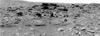
Here is a color-stitch of the great Sol 746 navcam-series:
 BTW.: is it just me or has anyone else noticed the slightly "blurred" quality of the recent Navcam frames (despite the now more clearer winter sky ... ?) esp. compared to last mars-year's crisp & clear navcam around the same time in the season ? |
|
|
|
|
Feb 8 2006, 08:58 PM
Post
#82
|
|
|
Senior Member Group: Members Posts: 2454 Joined: 8-July 05 From: NGC 5907 Member No.: 430 |
QUOTE (aldo12xu @ Feb 8 2006, 03:13 PM) I think we're looking at strata that has been tilted through meteorite impact. The stereo images below show the bedding planes to be dipping inward at an apparent angle of at least 20 degrees, best seen in the more erosion resistant layers sticking up above the outcrop in the top right. That implies these rocks were present before the meteorite impact. I thought the area Spirit landed in was covered in basalt, indicating volcanic activity. Of course who is to say it could not be a combination of both impacts and volcanoes? -------------------- "After having some business dealings with men, I am occasionally chagrined,
and feel as if I had done some wrong, and it is hard to forget the ugly circumstance. I see that such intercourse long continued would make one thoroughly prosaic, hard, and coarse. But the longest intercourse with Nature, though in her rudest moods, does not thus harden and make coarse. A hard, sensible man whom we liken to a rock is indeed much harder than a rock. From hard, coarse, insensible men with whom I have no sympathy, I go to commune with the rocks, whose hearts are comparatively soft." - Henry David Thoreau, November 15, 1853 |
|
|
|
|
Feb 8 2006, 08:58 PM
Post
#83
|
|
 Member Group: Members Posts: 646 Joined: 23-December 05 From: Forest of Dean Member No.: 617 |
Now _that's_ what we like to see!
http://qt.exploratorium.edu/mars/spirit/fo...55P1206R0M1.JPG My uneducated intuition makes me think the lower, thicker layers, which seem to have large grains (small pebbles?) embedded in them, are composed of volcanic ash rather than windblown (or water-washed) fine sediments. Of course intuition is reliably wrong... Question to the geologists: does rock formed from volcanic ash appear any different (to the instruments on Spirit) if the ash fell onto standing water, or onto dry land? Hmm, and I suppose if we imagine that there are repeated episodes of ash fall and periods under water, it will make a difference if the sediments between the water and the ash are water permeable? Clearly there's SOMETHING different between the lower, coarse layers and the higher fine layers. What else might it be? (this is a real question, not a rhetorical.) -------------------- --
Viva software libre! |
|
|
|
|
Feb 8 2006, 10:54 PM
Post
#84
|
|
|
Member Group: Members Posts: 320 Joined: 19-June 04 Member No.: 85 |
QUOTE (ljk4-1 @ Feb 8 2006, 08:58 PM) I thought the area Spirit landed in was covered in basalt, indicating volcanic activity. The Columbia Hills are older than the basaltic flows covering most of Gusev Crater. Some of the rocks within Columbia Hills are interpreted to be clastic (eg. Peace may be a basaltic sandstone) and pyroclastic (eg. Wishtone may be a tuff) in origin. These may represent the basement rocks that were present before the Gusev impact event. With the impact event, these basement rocks were thrown up, tilted and broken up, creating brecciated rocks like Voltaire. All these units were subsequently cut by dikes, represented by basaltic rocks like Backstay and Cherry Bomb. The plains basalts on which Spirit touched down were emplaced some time later. Hope that helps --Aldo-- -------------------- |
|
|
|
|
Feb 8 2006, 11:03 PM
Post
#85
|
|
|
Senior Member Group: Members Posts: 1229 Joined: 24-December 05 From: The blue one in between the yellow and red ones. Member No.: 618 |
QUOTE (imipak @ Feb 8 2006, 10:58 AM) Now _that's_ what we like to see! http://qt.exploratorium.edu/mars/spirit/fo...55P1206R0M1.JPG My uneducated intuition makes me think the lower, thicker layers, which seem to have large grains (small pebbles?) embedded in them, are composed of volcanic ash rather than windblown (or water-washed) fine sediments. Of course intuition is reliably wrong... Question to the geologists: does rock formed from volcanic ash appear any different (to the instruments on Spirit) if the ash fell onto standing water, or onto dry land? Hmm, and I suppose if we imagine that there are repeated episodes of ash fall and periods under water, it will make a difference if the sediments between the water and the ash are water permeable? Clearly there's SOMETHING different between the lower, coarse layers and the higher fine layers. What else might it be? (this is a real question, not a rhetorical.) Aha! But here it is! http://qt.exploratorium.edu/mars/spirit/mi...55P2936M2M1.JPG And what , pray tell, is it? If it's sandstone, I don't see any grains . If it's scoria, I don't see any gas spaces . If threatened with torture, if I don't talk, I would quote a Past Maestro of Home Plate" It's deja vu all over again! It's the kind of fabric Oppy has been sinking her abrasive into all over Meridiani! Smooth-lumpy STUFF! But a geologist would phrase it more ...esoterically. 
-------------------- My Grandpa goes to Mars every day and all I get are these lousy T-shirts!
|
|
|
|
|
Feb 8 2006, 11:26 PM
Post
#86
|
||
 Senior Member Group: Members Posts: 1887 Joined: 20-November 04 From: Iowa Member No.: 110 |
How about some color?
|
|
|
|
|
|
|
Feb 8 2006, 11:39 PM
Post
#87
|
|
|
Member Group: Members Posts: 646 Joined: 23-December 05 From: Forest of Dean Member No.: 617 |
QUOTE (Shaka @ Feb 8 2006, 11:03 PM) Aha! But here it is! http://qt.exploratorium.edu/mars/spirit/mi...55P2936M2M1.JPG And what , pray tell, is it? If it's sandstone, I don't see any grains . If it's scoria, I don't see any gas spaces . "Well... it's rock, isn't it?" /Arthur Dent Actually the blueberry-esque concave dimples in the lower, whitish (in that image) material has brought the word 'slots' floating up from some dusty recess of the distant past, 18 months or more ago. And really the darker, upper material *does* seem (to me) to be made up of sand-grains sized particles. As it happens there's an outside wall made of very soft grey-green sandstone about three feet <-- that way from my monitor that looks very like the farker material. it feels sandy if you rub your thumb over it, and there's a small heap of sand grains that have eroded out of it accumulating in tiny wind traps in the corners of wall and ground. It's a terrible building material - it weathers so fast that old older buildings in the area, there's a characteristic 'gumline' vertical profile - sort of a ' UUUUU ' shape, rotated through 90 degrees - where the mortar holding the wall together has withstood wind erosion more strongly than the building stone itself. Co-incidentally it looks a bit like the harder, then layers standing up proud of the adjacent layers, especially in the coarser-grained , thicker layers. Anyway... I'm still boggling over the image of Homeplate being flipped over like a pancake by an impact event
-------------------- --
Viva software libre! |
|
|
|
|
Feb 9 2006, 01:47 AM
Post
#88
|
|
|
Senior Member Group: Members Posts: 3419 Joined: 9-February 04 From: Minneapolis, MN, USA Member No.: 15 |
QUOTE (Shaka @ Feb 8 2006, 05:03 PM) Aha! But here it is! http://qt.exploratorium.edu/mars/spirit/mi...55P2936M2M1.JPG And what , pray tell, is it? If it's sandstone, I don't see any grains . If it's scoria, I don't see any gas spaces . ... I know I'm probably not seeing what I think I'm seeing. But it looks a little like limestone to me. It's got this flat-smooth-plates look to it that reminds me of limestone emplaced in hot springs. I'm probably wrong, but it's a lovely image... -the other Doug -------------------- The trouble ain't that there is too many fools, but that the lightning ain't distributed right. -Mark Twain
|
|
|
|
|
Feb 9 2006, 02:11 AM
Post
#89
|
||
 Senior Member Group: Moderator Posts: 2262 Joined: 9-February 04 From: Melbourne - Oz Member No.: 16 |
I haven't seen these two Pancam ESF's stitched together here yet.
It will be in full filter colour as soon as the data is down. CODE 746 p2364.15 26 26 0 0 2 54 pancam_barnhill_2cx1r_L234567Rall James -------------------- |
|
|
|
|
|
|
Feb 9 2006, 02:14 AM
Post
#90
|
|
|
Member Group: Members Posts: 166 Joined: 20-September 05 From: North Texas Member No.: 503 |
QUOTE (dvandorn @ Feb 9 2006, 01:47 AM) I know I'm probably not seeing what I think I'm seeing. But it looks a little like limestone to me. It's got this flat-smooth-plates look to it that reminds me of limestone emplaced in hot springs. I'm probably wrong, but it's a lovely image... -the other Doug Yes, similar to what you see at Mammoth Hot Springs in Yellowstone National Park. But deposits like that don't necessarily require *hot* springs; just a source of water with a high mineral content. I have seen lots of flowstone in caves with a similar look. And those are all cold water deposits. Now I am not suggesting that there was a cave involved. But cold water with lots of dissolved minerals would evaporate very quickly in the thin Martian atmosphere. And the fine-grained mineral deposits should build up steadily. Any sort of mineral spring, hot or cold, should be able to do the job. David |
|
|
|
|
Feb 9 2006, 03:04 AM
Post
#91
|
|
|
Senior Member Group: Members Posts: 2998 Joined: 30-October 04 Member No.: 105 |
This is a fine-grained indurated rock, and until we know the mineraoloy, that is all we can say.
One thing noteworthy: looking at Alan's RGB image of the slope at Homeplate posted today, the color of the dark toned rocks is a medium gray, with no trace of the usual ocher dust hue. Unusual because _everything_ here is dusty and itis odd to see rocks without that warm hue. --Bill -------------------- |
|
|
|
|
Feb 9 2006, 03:07 AM
Post
#92
|
||
|
Senior Member Group: Members Posts: 1229 Joined: 24-December 05 From: The blue one in between the yellow and red ones. Member No.: 618 |
QUOTE (imipak @ Feb 8 2006, 01:39 PM) "Well... it's rock, isn't it?" /Arthur Dent snip And really the darker, upper material *does* seem (to me) to be made up of sand-grains sized particles. snip If you're talking about the upper left quarter of the frame, I assume that is sand, blown onto this slab. The little yellow square represents the sort of view I assume this is (inverted, of course).
The actual rock seems to consist of a very-fine-grained matrix, perhaps enclosing some coarse granular clasts. Hence "smooth lumpy stuff". So much of the Meridiani evaporite had a similar look: http://qt.exploratorium.edu/mars/opportuni...44P2953M2M1.JPG Sure, the resemblance can be entirely superficial, representing entirely different constituents and origins...still...others have noted the similarity of HP and Burns Cliff on a macro scale.  think...gotta think about it... think...gotta think about it...
-------------------- My Grandpa goes to Mars every day and all I get are these lousy T-shirts!
|
|
|
|
|
|
|
Feb 9 2006, 03:08 AM
Post
#93
|
||
|
Senior Member Group: Members Posts: 1636 Joined: 9-May 05 From: Lima, Peru Member No.: 385 |
QUOTE (jamescanvin @ Feb 8 2006, 09:11 PM)
According to the above picture, I still have no good idea about how these around 25 degree slope of inclination are formed. As an example, the Endurance Crater has slope due to the impact crater and we can see the cross bedding as the ones of Home Plate. My best guess is that the Home Plate was formed by the accumulation of "limestones" produces by the hot water spring over thousand years (I don't think it is build up by millions but thousands years). But, this guess does not seem to be a strong since I cannot explain well about how the limestones were grown up if the water flush away on its borders. Maybe, a strong explosion from the nearby volcano at about 170-200 km north west of Gusev at Latitude : 7.5°S, Longitude : 187.2°W and has 5 km of Martian daturm: a Apolinaris Patera was erupted about 3 billions years ago (Hesperian age 3.5 Billions to 1.8 Billions years) and continued intermittently throughout the Hesperian period. The Spirit landing site is located near 14.8°S, 184.6°W. The initial effusive lava flows that formed the lower part of the dome were followed by more explosive eruptions of pyroclastic rocks and lavas to build the upper, steeper part of the structure. Depletion of the magma chamber by these eruptions or by withdrawal of the magma produced roof collapse and a large caldera. The last eruption from Apollinaris filled the caldera floor and overflowed from a narrow notch in the south wall of the crater. The above picture shows the flows of lava and probably the ash will go to toward southeast where is located the Gusev crater.  Mars_Global_Surveyor_MOC2_838_Release.html ( 2.88K )
Number of downloads: 479
Mars_Global_Surveyor_MOC2_838_Release.html ( 2.88K )
Number of downloads: 479Thus, to explore the region of Apollinaris Patera will provide important informations on the past volcanic activity on this region of Mars, and its different phases. Interaction between volcano and ground-ice is also visible in this region. Throughout the growth of the volcano, magmatic heating heating by dikes and other conduits, as well as by lava flows, melted ground ice within the regolith. The resulting desintegration and collapse of the terrain continued into the Late Hesperian and formed cluster of chaotic hills and mesas. Floods from Ma'adim Vallis, a large channel south of the map area, contributed to the breakup of surface rocks. Anyone have a better explanation about the formation of HP cone?  Rodolfo A mew update after reading the last post of DFinrock (David), I am able to explain about the formation of HP cone. Good David. Now I am not suggesting that there was a cave involved. But cold water with lots of dissolved minerals would evaporate very quickly in the thin Martian atmosphere. And the fine-grained mineral deposits should build up steadily. Any sort of mineral spring, hot or cold, should be able to do the job. David |
|
|
|
|
|
|
Feb 9 2006, 04:32 AM
Post
#94
|
|
|
Member Group: Members Posts: 166 Joined: 20-September 05 From: North Texas Member No.: 503 |
QUOTE (RNeuhaus @ Feb 9 2006, 03:08 AM) Anyone have a better explanation about the formation of HP cone? Rodolfo A new update after reading the last post of DFinfrock (David), I am able to explain about the formation of HP cone. Good David. But as Bill noted, we shouldn't make any assumptions about the type of rock until we know the mineralogy. It sure *looks* like CACO3... but looks can be deceiving. David |
|
|
|
|
Feb 9 2006, 05:43 AM
Post
#95
|
|
|
Member Group: Members Posts: 233 Joined: 21-April 05 Member No.: 328 |
Posts have been added so rapidly here that I may seem to be fairly far downstream from an earlier post by Dvandorn regarding the almost religious awe that these images inspire in him, but I would like to second his notion -- without lending any credence to "ID" -- that it is this kind of science which for many of us best expresses our spiritual yearnings.
And yes, some of this Home Plate stuff is very remeniscent of Meridiani! |
|
|
|
|
Feb 9 2006, 05:46 AM
Post
#96
|
|
|
Member Group: Members Posts: 233 Joined: 21-April 05 Member No.: 328 |
P.S. Any Teilhard de Chardin fans out there?
|
|
|
|
|
Feb 9 2006, 06:11 AM
Post
#97
|
|
 Member Group: Members Posts: 356 Joined: 12-March 05 Member No.: 190 |
How come a few miniTES samples haven't been taken/shown. They would be able to rule out something like CaCO3 immediately and they only take seconds to perform. Come to think of it, I can't remember the last time a miniTES data mosaic or spectrum was released in a press release. Its still working right? Last I heard the aluminum band around the piece of KBr beamsplitter that was supposed to crack it over the winter because of mismatched termal expansions never happened.....sooo
|
|
|
|
|
Feb 9 2006, 06:12 AM
Post
#98
|
|
|
Senior Member Group: Moderator Posts: 2262 Joined: 9-February 04 From: Melbourne - Oz Member No.: 16 |
This looks good
 CODE 748 p2271.05 72 0 0 72 2 146 pancam_Gibson_col_1_2_3_4_L257R127
748 p2272.05 36 0 0 36 2 74 pancam_Gibson_col_5_6_L257R127 -------------------- |
|
|
|
|
Feb 9 2006, 06:37 AM
Post
#99
|
|
 Senior Member Group: Members Posts: 2228 Joined: 1-December 04 From: Marble Falls, Texas, USA Member No.: 116 |
QUOTE (Bill Harris @ Feb 8 2006, 09:04 PM) This is a fine-grained indurated rock, and until we know the mineraoloy, that is all we can say. ... --Bill Well said. It's hard to say much else at this point. The rampant speculation is unwarranted. I share in the excitement this place induces in all of us. It's amazing. But we really need more info. -------------------- ...Tom
I'm not a Space Fan, I'm a Space Exploration Enthusiast. |
|
|
|
| Guest_Richard Trigaux_* |
Feb 9 2006, 07:53 AM
Post
#100
|
|
Guests |
QUOTE (glennwsmith @ Feb 9 2006, 05:43 AM) Posts have been added so rapidly here that I may seem to be fairly far downstream from an earlier post by Dvandorn regarding the almost religious awe that these images inspire in him, but I would like to second his notion -- without lending any credence to "ID" -- that it is this kind of science which for many of us best expresses our spiritual yearnings. And yes, some of this Home Plate stuff is very remeniscent of Meridiani! I would like to second this post too. Let us forget "beliefs" and especially dogmatism (or worse). My own spiritual life also feeds on the marvels of science results, especially of space exploration. When I was a kid, Mars was still drawn with the Schiaparelli "channels", and Titan was just a spot, I even ignored its name. I would have never dreamed to see one day a robot bringing back pictures of Mars rocks or Titan rocks... |
|
|
|
|

|
Lo-Fi Version | Time is now: 4th June 2024 - 10:11 AM |
|
RULES AND GUIDELINES Please read the Forum Rules and Guidelines before posting. IMAGE COPYRIGHT |
OPINIONS AND MODERATION Opinions expressed on UnmannedSpaceflight.com are those of the individual posters and do not necessarily reflect the opinions of UnmannedSpaceflight.com or The Planetary Society. The all-volunteer UnmannedSpaceflight.com moderation team is wholly independent of The Planetary Society. The Planetary Society has no influence over decisions made by the UnmannedSpaceflight.com moderators. |
SUPPORT THE FORUM Unmannedspaceflight.com is funded by the Planetary Society. Please consider supporting our work and many other projects by donating to the Society or becoming a member. |
|