Rosetta PDS, Images and other products made from archived data |

  |
Rosetta PDS, Images and other products made from archived data |
 Dec 14 2015, 10:48 PM Dec 14 2015, 10:48 PM
Post
#1
|
|
 Member  Group: Members Posts: 796 Joined: 27-February 08 From: Heart of Europe Member No.: 4057 |
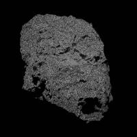
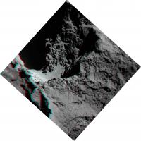
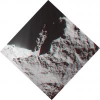
As we have now access to archived OSIRIS images and data from other instruments, I think that it's good idea to start up special topic for that.
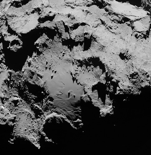
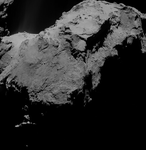
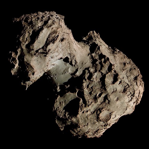
Here are few results from the newly published data: Hi-Res crosseye stereo color image of Imhotep regio at resolution 0.5 m/pix. 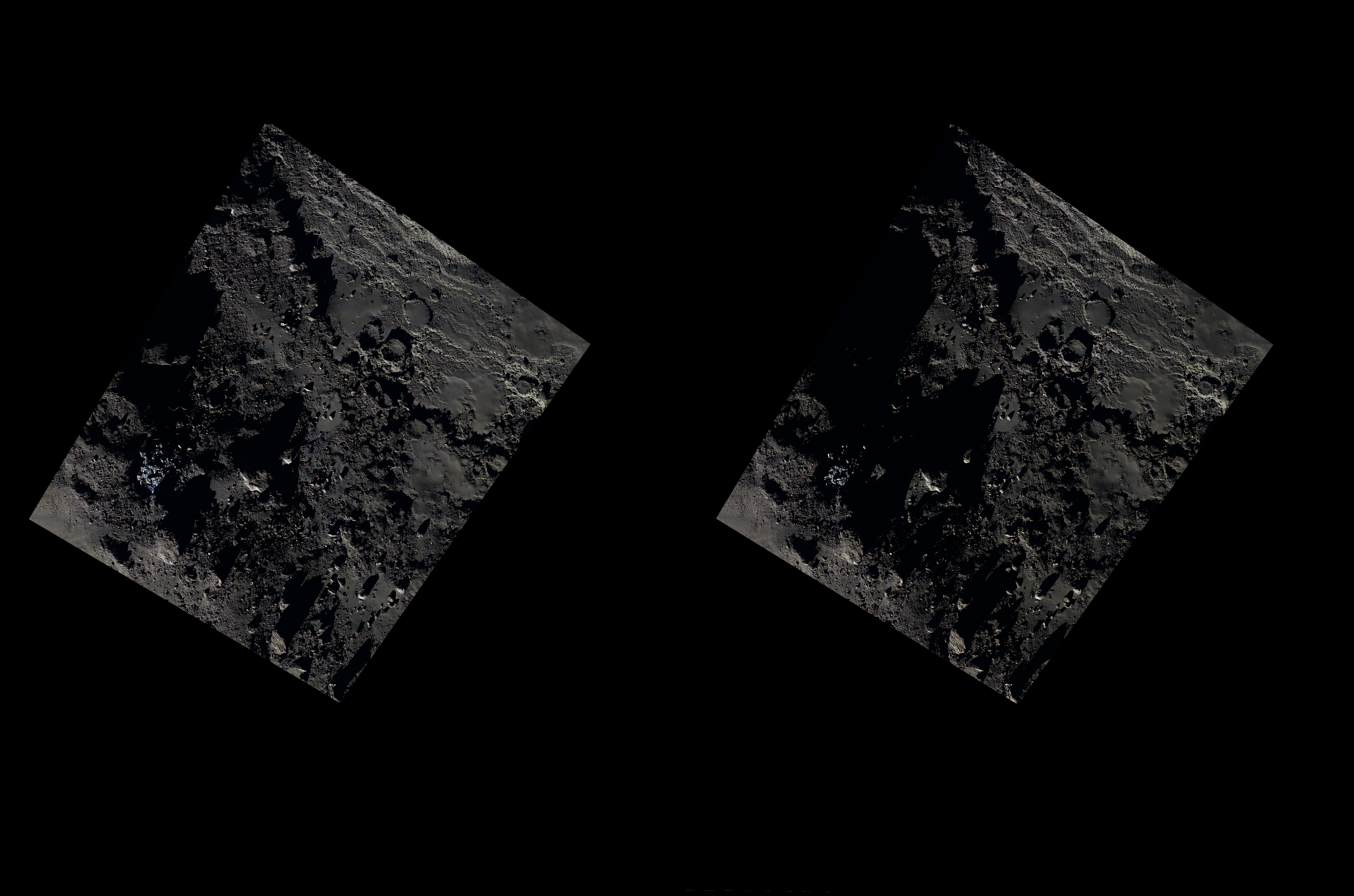 Anaglyph version: 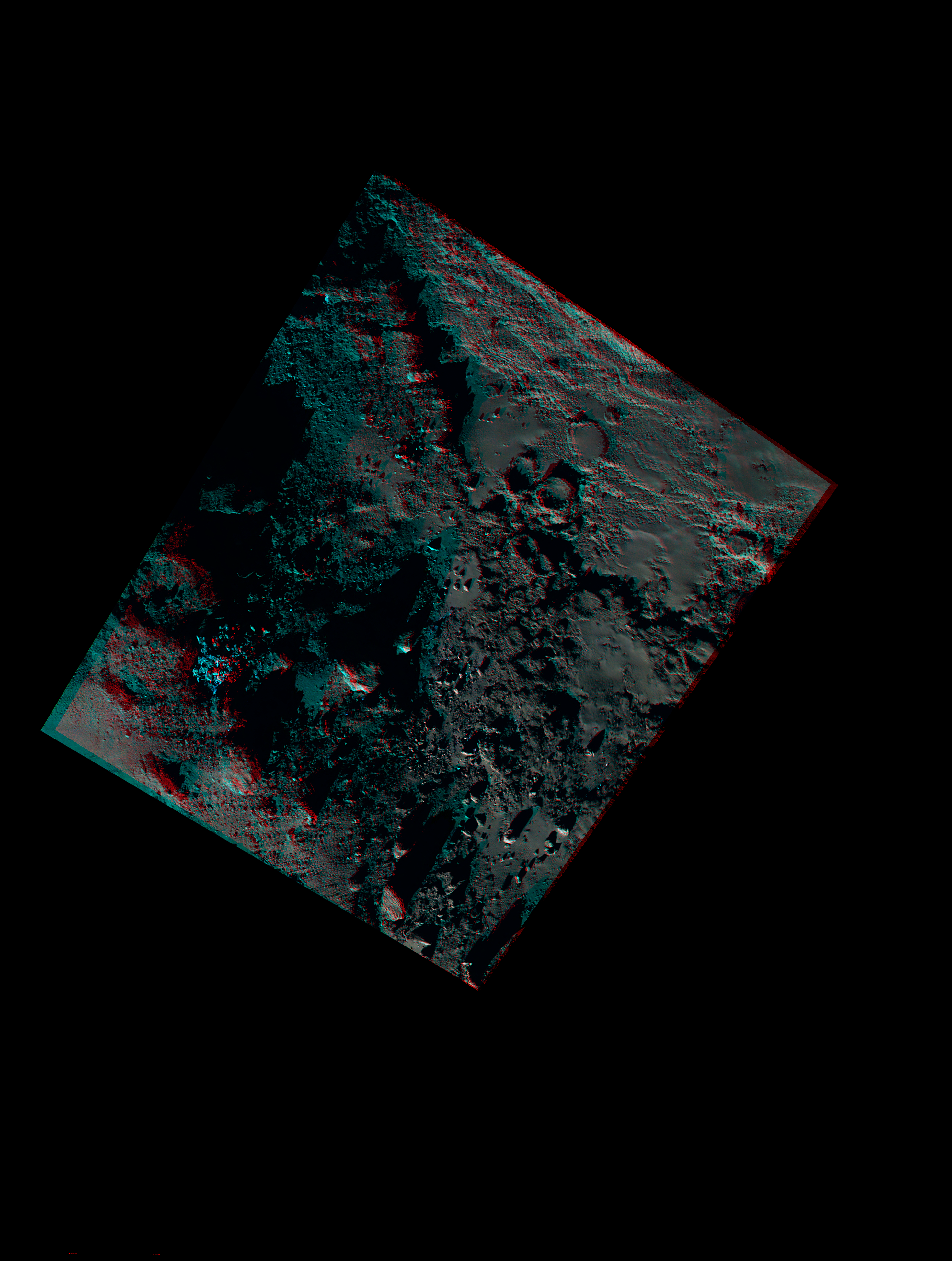 Global color image at 2.2 m/pix: 
-------------------- |
 |
 
|
|
Dec 15 2015, 12:14 AM
Post
#2
|
||
 Senior Member Group: Members Posts: 4247 Joined: 17-January 05 Member No.: 152 |
Very nice anaglyph.
I guess we can't say too much about the colour given that the hue is pretty much uncorrelated with the topography and looks mostly like noise:
|
|
|
|
|
|
|
Dec 15 2015, 01:01 AM
Post
#3
|
|
|
Member Group: Members Posts: 796 Joined: 27-February 08 From: Heart of Europe Member No.: 4057 |
Thanks!
There is real color difference between neck area (Hapi and Seth regio) and head and body. Neck is more bluish. But global image is from uncalibrated data and global color differences are very subtle. Beyond that are source images clearly affected by lossy compression and this had major impact on quality of images (in this case). Losslessly compressed images had better quality and noise looks in them differently (as periodic stripes). This isn't problem for unenhanced images but only objects which have distinctly different color without enhancing are water ice boulders. Those are visible mostly on higher resolution images (there is whole icy boulder field in the crosseye/anaglyph stereo image). -------------------- |
|
|
|
|
Dec 15 2015, 06:01 AM
Post
#4
|
|
 Administrator Group: Admin Posts: 5172 Joined: 4-August 05 From: Pasadena, CA, USA, Earth Member No.: 454 |
I made a set of data browsing pages, with WAC and NAC images grouped together and color-coded by filter.
http://planetary.s3.amazonaws.com/data/ros...osiris_fat.html http://planetary.s3.amazonaws.com/data/ros...osiris_cat.html http://planetary.s3.amazonaws.com/data/ros.../osiris_gm.html Enjoy! -------------------- My website - My Patreon - @elakdawalla on Twitter - Please support unmannedspaceflight.com by donating here.
|
|
|
|
|
Dec 15 2015, 08:17 AM
Post
#5
|
|
|
Member Group: Members Posts: 306 Joined: 4-October 14 Member No.: 7273 |
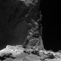
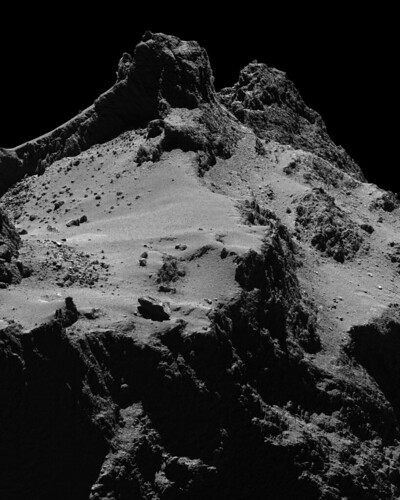
I assembled a 4 frame green filter mosaic of the Imhotep region taken on September 5, 2014 from an altitude of 40km. It's got a great view of the sublimation features, and the velvety texture of the smooth area near the terminator is great.
 I also tried my hand at making a color image. Might be a little on the pink/magenta side, but trying to adjust those made the shadowed areas too green/cyan, so the final result's a compromise between the two extremes. 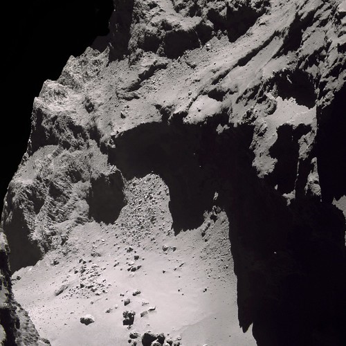
|
|
|
|
|
Dec 15 2015, 01:07 PM
Post
#6
|
|
 Member Group: Members Posts: 655 Joined: 22-January 06 Member No.: 655 |
QUOTE (machi @ Dec 14 2015, 10:48 PM)  As we have now access to archived OSIRIS images..... Does this mean Holger Sierks is back on our Stu's Christmas card list?? 
|
|
|
|
|
Dec 16 2015, 12:03 AM
Post
#7
|
|
 Member Group: Members Posts: 244 Joined: 2-March 15 Member No.: 7408 |
I took the 30 frames from W20140910T035912757ID30F18.IMG through W20140910T042812710ID30F18.IMG and made a full HD bounce animation of the slow rotation. A tiny preview version is included below.
(Click for 1920x1080)  It's hugenormous (65 MB), so beware; it may take a while to fully load, but it's one of the  est things I've seen from Rosetta. est things I've seen from Rosetta.The images were processed to show the area of the neck and connected regions that are in shadow. The frames were all captured 1 minute apart by the wide-angle camera, but are being played at ~15 frames per second. The 1920x1080 dimensions were achieved by cropping the original 2048x2048 frames, not scaling, so this is still at the native/original resolution. |
|
|
|
|
Dec 16 2015, 12:09 AM
Post
#8
|
|
|
Administrator Group: Admin Posts: 5172 Joined: 4-August 05 From: Pasadena, CA, USA, Earth Member No.: 454 |
That is AMAZING.
-------------------- My website - My Patreon - @elakdawalla on Twitter - Please support unmannedspaceflight.com by donating here.
|
|
|
|
|
Dec 16 2015, 12:34 AM
Post
#9
|
|
|
Senior Member Group: Members Posts: 2998 Joined: 30-October 04 Member No.: 105 |
QUOTE back on our Stu's Christmas card list?? Or, apropos, lumps of coal.QUOTE I took the 30 frames... and made a full HD bounce animation It's just like being there. I don't have the MIPS to do that, but I've worked up smallish animations with Navcam imagery to try to intuit the locations of some of the jets we've seen over the year.--Bill -------------------- |
|
|
|
|
Dec 16 2015, 01:59 AM
Post
#10
|
|
|
Junior Member Group: Members Posts: 30 Joined: 16-November 14 Member No.: 7323 |
That jet animation looks really nice! I always love how light bounces off of one of the lobes and illuminates the dark side of the other one... you dont get something like that with convex objects like most of the stuff buzzing around out there.
Also i gave that slomoVideo tool a quick try and applied it to six consecutive NAC frames (taken with different filters... but still relatively usable since the color differences are so small) https://drive.google.com/file/d/0B_Y5O4C6ai...iew?usp=sharing works best if played in a loop
|
|
|
|
|
Dec 16 2015, 02:31 AM
Post
#11
|
|
|
Member Group: Members Posts: 306 Joined: 4-October 14 Member No.: 7273 |
Herobrine, that bounce animation is gorgeous.
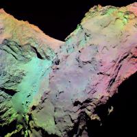
A three frame color mosaic of the Imhotep region. Hue in this image comes primarily from differing exposure lengths for each filtered image, I've only made minor adjustments to contrast because the shadows were a little on the green side. There might be a hint of color differences in this, as the center of the smooth region is slightly bluer than its surroundings. 
|
|
|
|
|
Dec 16 2015, 02:40 AM
Post
#12
|
||
|
Member Group: Members Posts: 244 Joined: 2-March 15 Member No.: 7408 |
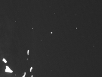
Noticed this little guy at the bottom of the animation I posted earlier.
(Click for animation)
This is rotated 90 degrees counter-clockwise from the original. A rock (I suppose) can be seen moving top-right to bottom-left. The star field is seen moving downward. Each frame was captured 60 seconds apart. It's headed back toward(ish) 67P in image space (it can be hard to tell since I have it bouncing). I wonder how long it has been 'airborne' here. |
|
|
|
|
|
|
Dec 16 2015, 04:12 AM
Post
#13
|
|
|
Junior Member Group: Members Posts: 25 Joined: 22-November 14 Member No.: 7349 |
I can only second the opinions of the rest, that's an amazing animation Herobrine!
jccwrt: Isn't that mosaic flipped horizontally? |
|
|
|
|
Dec 16 2015, 04:35 AM
Post
#14
|
|
|
Member Group: Members Posts: 306 Joined: 4-October 14 Member No.: 7273 |
Now that you mention it, it is. I have a hard time keeping track of which way is when working with FITS data...
I'll post a fixed version in the morning, I just noticed I missed a few smuts as well. |
|
|
|
|
Dec 16 2015, 02:51 PM
Post
#15
|
|
|
Member Group: Members Posts: 470 Joined: 24-March 04 From: Finland Member No.: 63 |
QUOTE (Herobrine @ Dec 16 2015, 12:03 AM) (Click for 1920x1080) It's hugenormous (65 MB), so beware; ... Use the following link with gifv animation automatically generated by imgur for faster loads. It uses a bit more up-to-date animation format: http://i.imgur.com/IJnKFMz.gifv Thanks for the animation Herobrine! -------------------- Antti Kuosmanen
|
|
|
|
|
Dec 16 2015, 04:29 PM
Post
#16
|
||
|
Member Group: Members Posts: 244 Joined: 2-March 15 Member No.: 7408 |
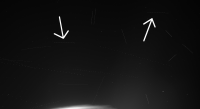
QUOTE (akuo @ Dec 16 2015, 09:51 AM) Use the following link with gifv animation automatically generated by imgur for faster loads. It uses a bit more up-to-date animation format: http://i.imgur.com/IJnKFMz.gifv Thanks for the animation Herobrine! imgur's "gifv" format is just a web page that serves either a .gif file, a .webm file, or a .mp4 file. In this case it's serving a lossy .webm file, displayed in an HTML5 <video> element with the "loop" and "autoplay" attributes set. imgur prefers to serve the lossy video formats for large, photographic animations because the file size is usually much smaller and saves them a lot of bandwidth. The GIF file I linked is the original, lossless (relative to the 8-bit result of my processing) version. The WebM video in your link is lossy compressed, so it is noticeably lower in quality, but still very , and clocking in at less than 2% the file size of the GIF, it may be a better option to anyone for whom bandwidth is a concern.The quality difference isn't a big deal with respect to aesthetic enjoyment, but it can make a difference, for example, if you're trying to find free-floating rocks (not sure what we're calling those, actually). The rock I pointed out a few posts back is visible in the WebM version too, but this fainter one I noticed later is only barely detectable in a few frames of the .WebM version as a smudge, but in the GIF version, a crop of which is seen below, the rock can be spotted in every frame (though very faint), as it moves from the bottom-left to the top-right, and back. (Click for GIF)
|
|
|
|
|
|
|
Dec 16 2015, 05:13 PM
Post
#17
|
|
|
Member Group: Members Posts: 306 Joined: 4-October 14 Member No.: 7273 |
Searching for those free-floaters is pretty fun! Haven't managed to find any new ones myself, but it's really neat seeing those little moonlets fly around.
I flipped the image of the Imhotep region horizontally, as well as did a bit of color adjustment to a slightly more neutral color. 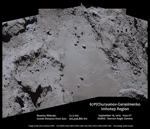
|
|
|
|
|
Dec 16 2015, 06:14 PM
Post
#18
|
|
|
Administrator Group: Admin Posts: 5172 Joined: 4-August 05 From: Pasadena, CA, USA, Earth Member No.: 454 |
I added the Navcam images to my browse pages, and also went through and reoriented and/or flipped all the images in this release so that everything now matches the Navcams. The NAC images needed to be flipped vertically; the WAC images rotated 180 degrees.
http://planetary.s3.amazonaws.com/data/ros.../osiris_gm.html -------------------- My website - My Patreon - @elakdawalla on Twitter - Please support unmannedspaceflight.com by donating here.
|
|
|
|
|
Dec 17 2015, 08:05 PM
Post
#19
|
||
 Senior Member Group: Members Posts: 3648 Joined: 1-October 05 From: Croatia Member No.: 523 |
QUOTE (fredk @ Dec 15 2015, 01:14 AM) I guess we can't say too much about the colour given that the hue is pretty much uncorrelated with the topography and looks mostly like noise: The strange noise-like aspect of the color variations has been bugging me ever since I saw the first color image released. In this dataset, I noticed some images don't appear to suffer from it, some do. Turns out it can vary even across a single image. Whole sections of roughly 500x500 pixel size can be affected. When you boost brightness, it shows a tell-tale sign of lossy compression. Turns out wavelet-like compression can be used by the flight software, but the compression params have to be among the weirdest I've seen. They preserve higher frequency detail while the low frequency component of around 16x16 blocks can be clobbered and this is what causes the mottling noticeable in color composites. Example attached. This is most noticeable in global images like this, perhaps they fixed it in subsequent observations. Related to this, most of the subsequent, really high res NAC green frames seem to be severely more compressed than red and blue counterparts, but at least the mottling seems to be gone.
-------------------- |
|
|
|
|
|
|
Dec 18 2015, 12:02 AM
Post
#20
|
|
|
Member Group: Members Posts: 306 Joined: 4-October 14 Member No.: 7273 |
A couple of OSIRIS mosaics capturing most of the comet:
  And one of the Seth(?) Region with a really great view of the layering. Does a great job showing how extensive the layered units are in the comet. 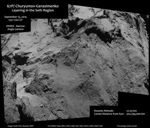
|
|
|
|
|
Dec 20 2015, 08:25 PM
Post
#21
|
|
|
Member Group: Members Posts: 796 Joined: 27-February 08 From: Heart of Europe Member No.: 4057 |
QUOTE (elakdawalla @ Dec 16 2015, 07:14 PM) I added the Navcam images to my browse pages, and also went through and reoriented and/or flipped all the images in this release so that everything now matches the Navcams. The NAC images needed to be flipped vertically; the WAC images rotated 180 degrees. http://planetary.s3.amazonaws.com/data/ros.../osiris_gm.html Thank you Emily! It's very useful! I used your converted PNGs for these mosaics. First image is global color mosaic which combine WAC frames with NAC frames. Second mosaic has enhanced colors and it shows color differences on the 67P surface. As they both use the same NAC frames, best resolution is the same - ~0.8 m/pix.   -------------------- |
|
|
|
|
Dec 20 2015, 10:57 PM
Post
#22
|
||
|
Member Group: Members Posts: 306 Joined: 4-October 14 Member No.: 7273 |
Wow.
That's quite the range of color variation! Excellent work, machi! I looked for more moonlets in Herobrine's gif, this one jumped out at me on the right edge of the image.
|
|
|
|
|
|
|
Dec 21 2015, 05:43 PM
Post
#23
|
|
|
Member Group: Members Posts: 244 Joined: 2-March 15 Member No.: 7408 |
QUOTE (jccwrt @ Dec 20 2015, 05:57 PM) I looked for more moonlets in Herobrine's gif, this one jumped out at me on the right edge of the image. Edit: I see it now. Good eye! I kinda felt bad about not putting a little more effort into the animation given that it was so well-received and Emily even put it up on Planetary. The flickering background is really distracting to me, and it's like that because the program I wrote to spit it out used whatever the minimum value in the data was as the output zero point, and that changes from frame to frame. The maximum used was calculated in a more complex way, but also varied from frame to frame. Doing it per-frame was a bad idea and unnecessary since all 30 frames had the same filter (Empty_VIS610) and exposure time (10.2 seconds). So, I modified it to use 0 as the minimum (or something else constant; I can't remember; I tried it many different ways) and a constant maximum. I also rotated it 180 degrees like Emily did for Planetary. It looked a lot better, but I didn't ever post the improved version because I felt like it was beating a dead horse. However, since it seems some people have been looking for floaters/moonlets, I'll post this version which is much better for that. Tiny preview below. Click for full-size (2222x2049, 63 MiB)  This version is built from the improved output (so no flickering background) and this time, the entire frames are included (no 1920x1080 crop) and they are all aligned1 to the background star field so stars don't move2, making it much easier to see anything floating around. The dimensions are 2222x2049 (instead of 2048x2048) because the frame position changes over time to keep the stars stationary. Empty regions at the sides, outside the bounds of a frame have been filled in with averages of other frames that did cover it. No bounce this time. At the end, it switches briefly to a frame that shows the positions, in every frame I could detect them, of 27 floaters/moonlets that I noticed in a search of the frames, overlaid on an average of all 30 frames, aligned to stars. Here's a little crop showing what it looks like. Notice the stationary star field and the track of the object that can be seen moving. 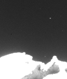 Click here for just the frame with the 27 tracks on it.  Each white pixel3 marks the detected position of an object in a single frame. Some of the objects are so faint that you may not be able to see them in the animation without adjusting the frame brightness/contrast. I found them by subtracting the average of all 30 frames (aligned to the star field) from each individual frame and then stacking the resulting frames in a "lighten only" way so that any moving object brighter than the background would appear as a series of dots. I checked the original frames to verify that each apparent trail was an actual object and to find the precise pixel to assign it for each frame. 1 - To the nearest pixel. I didn't want to damage the data by allowing it to be resampled/interpolated. 2 - Stars near the left and right side of the frame actually do drift very slowly by several pixels over the course of the 30 frames. 3 - Some positions are marked by two pixels where the object center (brightest point, really) fell near the boundary between pixels. |
|
|
|
|
Dec 21 2015, 07:21 PM
Post
#24
|
|
 Member Group: Members Posts: 404 Joined: 5-January 10 Member No.: 5161 |
Herobrine, that is awesome work! Amazing how many moonlets you teased out of the data. And thanks to all you other imagery wizards. Wish I had more time to participate...
|
|
|
|
|
Dec 21 2015, 07:26 PM
Post
#25
|
|
|
Newbie Group: Members Posts: 6 Joined: 17-November 14 Member No.: 7331 |
Some attempts
 |
|
|
|
|
Dec 22 2015, 09:35 AM
Post
#26
|
|
|
Member Group: Members Posts: 306 Joined: 4-October 14 Member No.: 7273 |
Herobrine, I think you scooped up most of the floaters, there almost weren't any left for me to find!
 I did manage to find a handful of other floaters. Most of them are very close to disappearing in sensor noise. I didn't go through and mark their positions in each frame, since they fade in and out of view, but I did mark their paths in yellow lines. 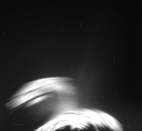 Full size here The one at bottom left very well could be a hot pixel, since it's moving pretty much horizontally and close to the same rate as frame movement. Otherwise I'm pretty sure the other ones are actual floaters. |
|
|
|
|
Dec 22 2015, 12:26 PM
Post
#27
|
||
|
Member Group: Members Posts: 244 Joined: 2-March 15 Member No.: 7408 |
Good finds!
Though, now that you mention it, these two in the one I posted yesterday appear to move with the frame as well. I guess I should have realized they're more likely to be sensor artefacts of some sort.
Oops! |
|
|
|
|
|
|
Dec 22 2015, 04:30 PM
Post
#28
|
|
|
Senior Member Group: Members Posts: 2998 Joined: 30-October 04 Member No.: 105 |
Herobrine-- in your third "stacked" non-animated image (http://www.unmannedspaceflight.com/uploads/post-7408-1450718176.png) I note that some of the dust-mote dotted trails have a kink or a bend in them. Is this actually happening, or is this an artifact of the imaging or processing? I also noticed this happening with some of the long-exposuer NavCam images. In some ways, they look/act like subatomic particles in a bubble chamber...
--Bill -------------------- |
|
|
|
|
Dec 22 2015, 06:17 PM
Post
#29
|
|
|
Member Group: Members Posts: 244 Joined: 2-March 15 Member No.: 7408 |
QUOTE (Bill Harris @ Dec 22 2015, 11:30 AM) Herobrine-- in your third "stacked" non-animated image (http://www.unmannedspaceflight.com/uploads/post-7408-1450718176.png) I note that some of the dust-mote dotted trails have a kink or a bend in them. Is this actually happening, or is this an artifact of the imaging or processing? I don't immediately notice a kink or bend in any of the trails. Some of them are a little jittery because one pixel in any direction is enough difference to make it look that way. I've added numbers for the trails here. Some (#13, for example) are a little curved, I'd guess because their orbital plane is nearly parallel to the image plane. Can you tell me the number of one of the kinked/bent ones? |
|
|
|
|
Dec 23 2015, 11:49 PM
Post
#30
|
|
 IMG to PNG GOD Group: Moderator Posts: 2251 Joined: 19-February 04 From: Near fire and ice Member No.: 38 |
QUOTE (machi @ Dec 20 2015, 08:25 PM) Second mosaic has enhanced colors and it shows color differences on the 67P surface. Great color mosaic, probably the best one I've seen. Which filter combination did you use for the color? |
|
|
|
|
Dec 24 2015, 12:55 AM
Post
#31
|
|
|
Member Group: Members Posts: 796 Joined: 27-February 08 From: Heart of Europe Member No.: 4057 |
Thanks Björn!
There is basic info about that image in the Flickr page. I used red, green and near UV filters so it's slightly extended beyond human vision capability but it does not use whole spectral capabilities of OSIRIS NAC camera. -------------------- |
|
|
|
|
Dec 27 2015, 11:25 PM
Post
#32
|
||
|
IMG to PNG GOD Group: Moderator Posts: 2251 Joined: 19-February 04 From: Near fire and ice Member No.: 38 |
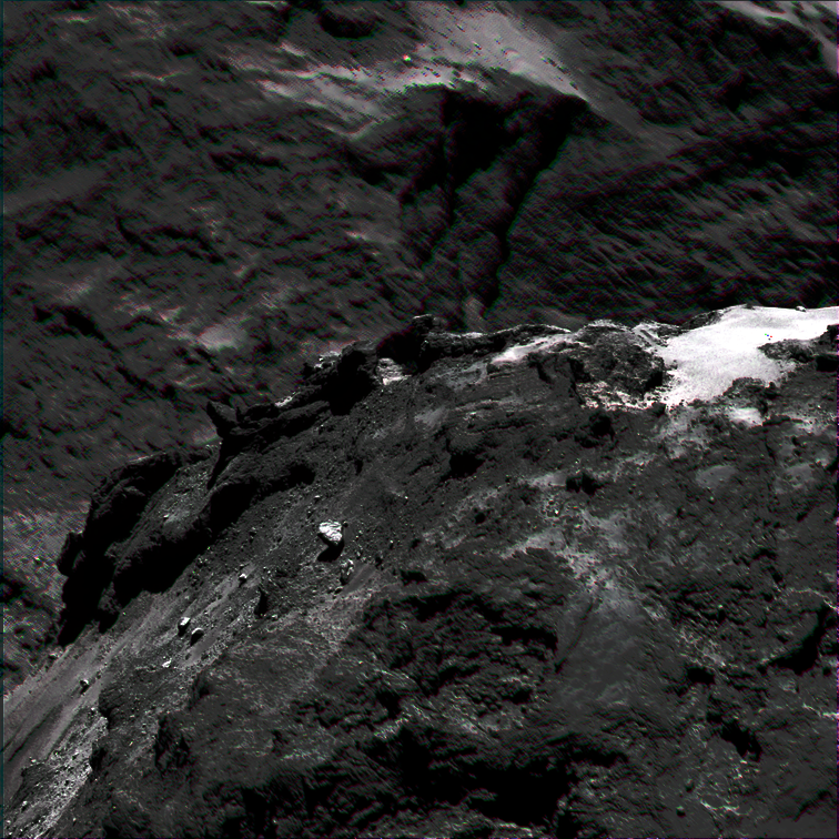
This is a wonderful data set. Having at first spent some time fixing IMG2PNG I now have flipped through all of the September 2014 NAC images. Here is a quick and dirty version of image N20140910T161923332ID30F22.IMG (there's more to come later):
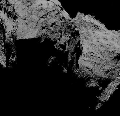
Since this is a 16 bit data set the dynamic range is high. It turns out that many images contain lots of details in the shadowed regions. The image above has been processed to reveal details in the shadowed regions (they were almost black in the original image) without losing significant amounts of contrast in the bright regions. Had the source image been an 8 bit image there would have been only three levels of gray in the shadowed regions. |
|
|
|
|
|
|
Dec 28 2015, 10:21 PM
Post
#33
|
|
|
Administrator Group: Admin Posts: 5172 Joined: 4-August 05 From: Pasadena, CA, USA, Earth Member No.: 454 |
This is not technically PDS data, but is relevant to work people are doing here. I've been provided two lists of navigational data (attached):
- a list of all of the OCMs performed to date by Rosetta. It lists start and stop times but these are not the exact burn start and stop times; they are the full lengths of the periods set aside for OCM activities, including slews, pointing, margin, etc. - a zip file containing Rosetta altitude information at a 1-minute resolution from June 1, 2014 to December 17, 2015. I'll find some way to add this to my index pages, but thought the raw data might come in handy to some of you, or that you may have some clever ideas for how to visualize it.
Attached File(s)
 OCM_list.dat.txt ( 18.27K )
Number of downloads: 954
OCM_list.dat.txt ( 18.27K )
Number of downloads: 954 rosetta_altitude.zip ( 4.58MB )
Number of downloads: 954
rosetta_altitude.zip ( 4.58MB )
Number of downloads: 954-------------------- My website - My Patreon - @elakdawalla on Twitter - Please support unmannedspaceflight.com by donating here.
|
|
|
|
|
Jan 2 2016, 08:56 PM
Post
#34
|
||||
|
IMG to PNG GOD Group: Moderator Posts: 2251 Joined: 19-February 04 From: Near fire and ice Member No.: 38 |
Here is a false color view processed to show color/compositional differences:
This is from images N20140821T154228701ID30F41.IMG, N20140821T154304911ID30F23.IMG and N20140821T154327701ID30F16.IMG. Here near-IR, green and near-UV are displayed as red, green and blue, respectively. Color saturation has been greatly exaggerated to show color/compositional variations. Due to the relative motion between the spacecraft and the comet while the images were obtained I had to warp the near-IR and near-UV images to register them to the green image. This was not quite sufficient to get nice results at the shadow edges so I blurred the resulting color image (in effect reducing its resolution by a factor of ~5) and then pasted the color from the blurred image into the green image. Some color artifacts are still visible near the shadows but they are greatly reduced and all of the large scale color variations and color variations in areas far from shadows are real. And here is an anaglyph from images N20140914T210304360ID30F22.IMG and N20140914T210355741ID30F41.IMG:
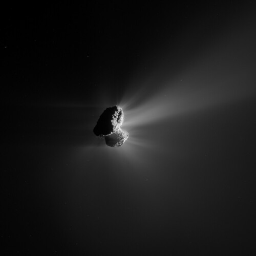
This is a wonderful data set for producing spectacular anaglyphs. There are many tens of possible anaglyphs 'lurking' in the collection of IMG files. Here is another one. Not quite as spectacular but it has been processed to reveal jets of material at the limb and also to show the comet's shadowed limb. This is from images N20140914T202748367ID30F22.IMG and N20140914T202839748ID30F41.IMG:
|
|||
|
|
|
|||
|
May 5 2016, 03:33 AM
Post
#35
|
|
|
Administrator Group: Admin Posts: 5172 Joined: 4-August 05 From: Pasadena, CA, USA, Earth Member No.: 454 |
I can't believe that no one has posted about this yet
http://blogs.esa.int/rosetta/2016/05/04/os...ander-delivery/ I've downloaded all the WAC data and am almost done with the NAC; I'm exercising the new version of IMG2PNG and will have browse pages with metadata and filter information available as soon as I can. -------------------- My website - My Patreon - @elakdawalla on Twitter - Please support unmannedspaceflight.com by donating here.
|
|
|
|
|
May 5 2016, 05:30 AM
Post
#36
|
|
|
Member Group: Members Posts: 306 Joined: 4-October 14 Member No.: 7273 |
Not quite sure where on 67P this was taken. I wanna say Serqet.
 This is a four-frame mosaic taken through the OSIRIS NAC on October 14, 2014 at a distance of around 11 km. EDIT: some more mosaics and stuff Two frame mosaic from October 5, 2014, distance 18.79 km 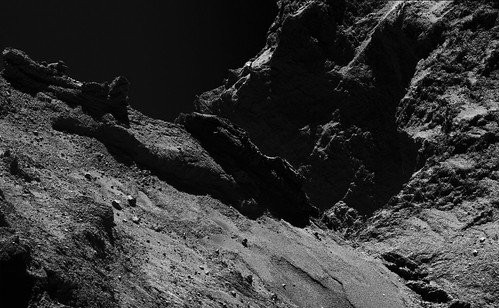 Four frame mosaic from December 13, 2014, distance 19.20 km 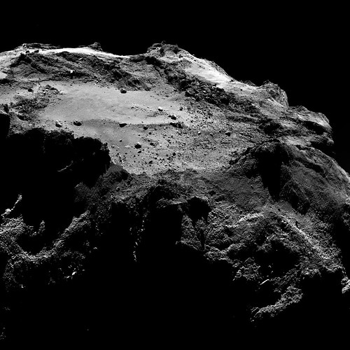 And a few wiggle gifs to show topography. (These are around 6 mb apiece, so I'll just leave a link for slow connections) September 30. 2014. Parallax was from 12 minutes of spacecraft motion. Altitude 18.10 km October 1, 2014. Parallax was from 11 minutes of spacecraft motion. Altitude 18.20 km November 12, 2014. You can see Philae heading in for a landing if you look carefully! Parallax was from 5 minutes of spacecraft motion |
|
|
|
|
May 6 2016, 06:26 PM
Post
#37
|
|
|
Administrator Group: Admin Posts: 5172 Joined: 4-August 05 From: Pasadena, CA, USA, Earth Member No.: 454 |
BEHOLD. Rosetta OSIRIS and Navcam data for:
Far Approach Trajectory (July 2-August 6, 2014) Close Approach Trajectory (August 6-September 10, 2014) Global Mapping Phase (September 10-October 15, 2014) Close Observation Phase (October 15-31, 2014) Lander Delivery Phase (October 31-November 21, 2014) Escort Phase (November 21, 2014-) New stuff begins at the end of the Global Mapping Phase. I'm likely to be making slight tweaks to these pages but all the data are linked. Have at it! EDIT: I have trouble with the FTP links to IMG and LBL files from Chrome but they work for me in Firefox. -------------------- My website - My Patreon - @elakdawalla on Twitter - Please support unmannedspaceflight.com by donating here.
|
|
|
|
|
May 8 2016, 09:17 AM
Post
#38
|
|
|
Junior Member Group: Members Posts: 78 Joined: 20-September 14 Member No.: 7261 |
All 1147 OSIRIS pictures of the escort phase were taken up until December 19, 2014 (one month after lander delivery).
The Escort Phase (MTP10+) by ESA nomenclature ended on December 31st, 2015 due to nominal mission end and was succeeded by the Extension Phase (MTP25+). The latest NAVCAM pictures of the Extension Phase released in the archive are from February 10th, 2016. |
|
|
|
|
May 10 2016, 04:25 PM
Post
#39
|
|
|
Member Group: Members Posts: 244 Joined: 2-March 15 Member No.: 7408 |
Here's my quick attempt at spotting Philae during its descent in the newly-released OSIRIS NAC data.
 Probably didn't get all of the NAC frames with it, but that's most of them. It's enlarged 3x here with no interpolation. I used the PNGs on Planetary's site for this one. Normally, I'd use the IMGs from PSA, but I was just throwing it together for my own amusement. Also, here. People seemed to like this kind of thing in the past. These are mostly 8-20 minute time-steps, so they lack some of the feeling-like-you're-there quality the one I posted a while back had; that one had (I think) 1 minute time-steps. I did use the PSA data for these. Click on the animations below for full-size versions (they're enormous). 2014-11-22  2014-11-24  2014-11-28 
|
|
|
|
|
May 11 2016, 03:43 AM
Post
#40
|
|
|
Merciless Robot Group: Admin Posts: 8784 Joined: 8-December 05 From: Los Angeles Member No.: 602 |
 ...absolutely gob-smacking, as they say. That's truly stunning work, Hero; thank you!!! ...absolutely gob-smacking, as they say. That's truly stunning work, Hero; thank you!!! 
-------------------- A few will take this knowledge and use this power of a dream realized as a force for change, an impetus for further discovery to make less ancient dreams real.
|
|
|
|
|
May 11 2016, 03:56 PM
Post
#41
|
|
|
Member Group: Members Posts: 923 Joined: 10-November 15 Member No.: 7837 |
Herobrine is my hero!
-------------------- |
|
|
|
|
Jun 28 2016, 04:15 PM
Post
#42
|
|
 Senior Member Group: Members Posts: 1729 Joined: 3-August 06 From: 43° 35' 53" N 1° 26' 35" E Member No.: 1004 |
new image release.
be sure to check out the shadow sequence! http://blogs.esa.int/rosetta/2016/06/28/os...g-shadow-flyby/ |
|
|
|
|
Oct 1 2016, 11:29 AM
Post
#43
|
|
|
Junior Member Group: Members Posts: 30 Joined: 16-November 14 Member No.: 7323 |
Not sure if anybody has bothered to do this up til now, but i wrote a little tool to create 32bit floatingpoint greyscale tiff files from the original osiris IMG files in order to get the full dynamic range stored in there (they also use floats...). Though i am not sure if there is more information than in the 16bit png files. If there is interest in playing with this i can clean the code up a little and post a link.
Attached a few quick and dirty images where i tried to pull stuff out of the shadows I wonder if it is possible to use the calibration images in the database to get rid of som of the banding artefacts in there    |
|
|
|
|
Oct 1 2016, 07:49 PM
Post
#44
|
|
|
Member Group: Members Posts: 890 Joined: 18-November 08 Member No.: 4489 |
hi chuck0
nice images i take to you are not aware that GDAL can convert pds img/lbl files to a geotiff an example CODE gdal_translate ros_cam1_20160810t015931.lbl ros_cam1_20160810t015931.tiff http://sbn.pds.nasa.gov/holdings/ro-c-navc...v1.0/data/cam1/ from the label CODE /*** IMAGE DESCRIPTION ***/ OBJECT = IMAGE DERIVED_MAXIMUM = 4095 DERIVED_MINIMUM = 177 LINES = 1024 LINE_SAMPLES = 1024 SAMPLE_TYPE = LSB_UNSIGNED_INTEGER SAMPLE_BITS = 16 SOURCE_SAMPLE_BITS = 12 SAMPLE_DISPLAY_DIRECTION = "RIGHT" LINE_DISPLAY_DIRECTION = "UP" END_OBJECT = IMAGE a 12 bit image converted to 16 bit 
|
|
|
|
|
Oct 2 2016, 12:10 AM
Post
#45
|
|
|
Junior Member Group: Members Posts: 30 Joined: 16-November 14 Member No.: 7323 |
Thanks for pointing me to this tool! Though since geotiffs (and the pngs in the archive) are 16bit greyscales and the original data in the IMG files is 32bit float greyscale i wasnt sure whether some of the information is being lost by doing this conversion... but after looking at quite a few of the images i converted it seems like they just chose 32 bit floats in the IMG files in order to actually store the data in its correct physical units. So a 32bit conversion is not really useful anyways and i would have been better off simply using the publicly available png files
 Anyways, it was a nice exercise in getting to know the image data format they are using
|
|
|
|
|
Oct 2 2016, 12:49 AM
Post
#46
|
|
|
Member Group: Members Posts: 890 Joined: 18-November 08 Member No.: 4489 |
the img files are not 32 bit float
they are 16 bit LSB unsigned as per the label on the img file QUOTE SAMPLE_TYPE = LSB_UNSIGNED_INTEGER SAMPLE_BITS = 16 |
|
|
|
|
Oct 2 2016, 09:48 AM
Post
#47
|
|
|
Junior Member Group: Members Posts: 30 Joined: 16-November 14 Member No.: 7323 |
That label is for a NAVCAM image file, not an OSIRIS one. The OSIRIS ones are 32bit float
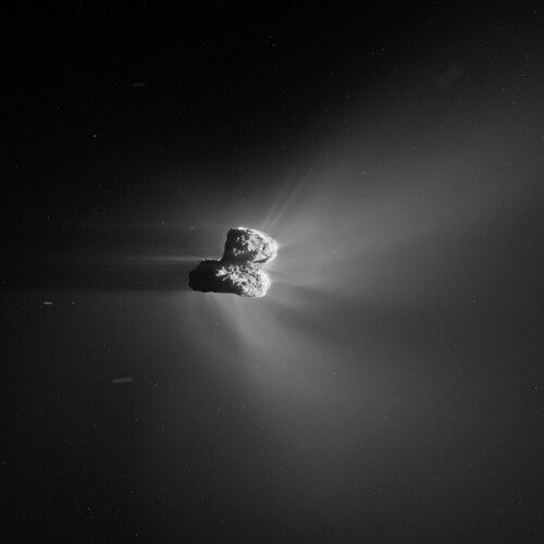
http://imagearchives.esac.esa.int/picture....26/category/252 QUOTE Object = IMAGE INTERCHANGE_FORMAT = BINARY LINES = 2048 LINE_SAMPLES = 2048 FIRST_LINE = 1 FIRST_LINE_SAMPLE = 1 SAMPLE_TYPE = PC_REAL SAMPLE_BITS = 32 BANDS = 1 UNIT = W/M**2/SR/NM SAMPLE_DISPLAY_DIRECTION = RIGHT LINE_DISPLAY_DIRECTION = DOWN End_Object Played a bit more with some of the OSIRIS images... havent seen that one on here yet:  it is the WAC version of the spacecrafts shadow on the comet image. Also, there is one patch of stuff that looks like ice above and slightly to the left of Rosettas shadow .The next one is an overexposed view of comet activity... love those images because they show off pretty nicely what makes comets such special small bodies  If you zoom in you can also see a huge number of small/faint streaks which i would assume are a bit larger/closer particles leaving the comet? |
|
|
|
|
Oct 2 2016, 07:57 PM
Post
#48
|
|
|
Junior Member Group: Members Posts: 30 Joined: 16-November 14 Member No.: 7323 |
Also, since i love color pictures and the global comet images show so few color variations i took a look at the zero phase angle flyby. There is quite a bit of variation across the three bands that are available (Red, Orange, Blue)... registering them is pretty straight forward since it is primarily only a rotation/translation.
   It is really a pity that there is only one proper WAC OSIRIS image of that flyby. |
|
|
|
|
Feb 7 2017, 01:55 AM
Post
#49
|
|
|
Member Group: Members Posts: 306 Joined: 4-October 14 Member No.: 7273 |
Most recent release of OSIRIS data is finally working, so I put together a color image taken on March 3. This should be in approximately true color (using images from VIS_BLUE, VIS_GREEN, and VIS_RED), with the caveat that the saturation has been increased a little to make the subtle color variation a little more obvious.
|
|
|
|
|
Feb 8 2017, 03:06 PM
Post
#50
|
|
|
Member Group: Members Posts: 306 Joined: 4-October 14 Member No.: 7273 |
A couple of tries at doing some HDR work with the OSIRIS wide-angle far excursion coma studies.
|
|
|
|
|
Oct 23 2018, 10:16 PM
Post
#51
|
|
|
Member Group: Members Posts: 796 Joined: 27-February 08 From: Heart of Europe Member No.: 4057 |
I wrote new article for my blog after more than 4 year hiatus (hibernation?).
It's a first part of few (5+) articles covering mostly color imaging of 67P comet from the Rosetta spacecraft. First part is mainly about history of cometary nuclei imaging to put Rosetta mission in to the context and it contains only 2 images of 67P on the end of article, but on other side it also contains 6 new reprocessed images of cometary nuclei from different mission (VeGa-2, Deep Space 1 , Deep Impact, Stardust and others). Article is in the Czech language but it should readable via Google translator (translator button is on the page) and basic info about images is already in the English language. Here are two new images of comet 67P via Flickr taken in the beginning of the mission (5. August 2014). First is close to real colors and it uses three images taken through orange, green and blue filter (details in the link). 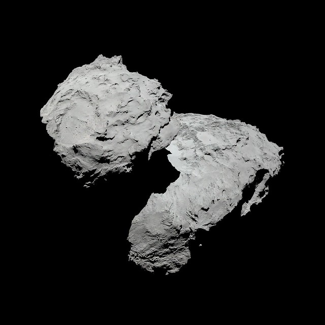 Second image has spectrally extended and enhanced colors and it's from the same sequence but now near-IR image is used as red image and orange image is used as green image in the RGB composite. 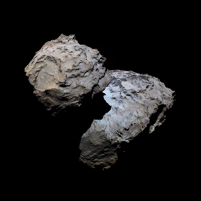 I have also already some 50% of images for the second part of article series which should be about global mapping of 67P comet. Images are available on my Flickr account and here are few examples in spectrally extended and enhanced colors later in the mission when comet was more active. All of them are made using near-IR, orange and blue images as RGB composite. 24. June 2015. 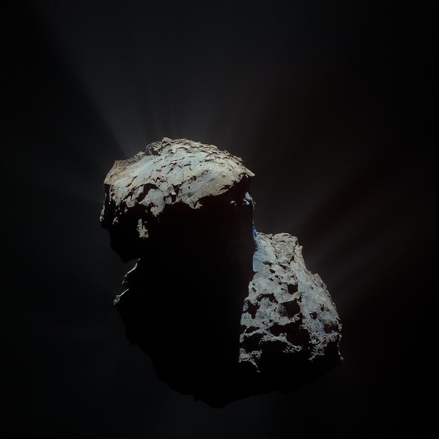 12. April 2015. 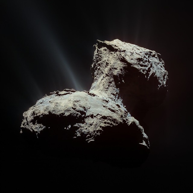 22. November 2015 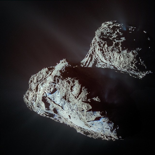 -------------------- |
|
|
|
|
Oct 24 2018, 01:45 AM
Post
#52
|
|
|
Senior Member Group: Members Posts: 2086 Joined: 13-February 10 From: Ontario Member No.: 5221 |
Gorgeous work Machi! The clear outline of the night portion is always a neat sight, thanks to the coma making the background less than the usual black for completely airless bodies.
Your blog post also reminded me, if only Giotto's camera hadn't broken, I wonder what Halley would have looked like up close? What sort of resolution would have been possible? If we want a Rosetta style rendezvous mission in 2061, it's best to start planning now! |
|
|
|
|
Oct 24 2018, 07:25 AM
Post
#53
|
|
|
Member Group: Members Posts: 102 Joined: 29-January 10 From: Poland Member No.: 5205 |
Wow. It's great work machi. I will wait for other articles
-------------------- Adam Hurcewicz from Poland
|
|
|
|
|
Oct 24 2018, 12:09 PM
Post
#54
|
|
|
Member Group: Members Posts: 796 Joined: 27-February 08 From: Heart of Europe Member No.: 4057 |
QUOTE (Explorer1 @ Oct 24 2018, 03:45 AM) Gorgeous work Machi! The clear outline of the night portion is always a neat sight, thanks to the coma making the background less than the usual black for completely airless bodies. QUOTE (Adam Hurcewicz @ Oct 24 2018, 09:25 AM) Wow. It's great work machi. I will wait for other articles Thanks! QUOTE (Explorer1 @ Oct 24 2018, 03:45 AM) Your blog post also reminded me, if only Giotto's camera hadn't broken, I wonder what Halley would have looked like up close? What sort of resolution would have been possible? If we want a Rosetta style rendezvous mission in 2061, it's best to start planning now! On paper, hi-res images should have up to 13 m/pix resolution but I think that images from the closest distance would be significantly affected by the dust. This effect is already visible in the highest resolution images which were send to Earth. They have very low contrast. I think that more interesting would be images covering opposite hemisphere of the comet as that hemisphere was better illuminated by the Sun. But Giotto was simply very risky and bold mission barely comparable to anything else. With flyby speeds near 70 km/s in distance 600 km from the most active comet ever visited by humanity, no other mission comes close to that. In the end it did pretty good job! -------------------- |
|
|
|
|

|
Lo-Fi Version | Time is now: 26th May 2024 - 03:27 AM |
|
RULES AND GUIDELINES Please read the Forum Rules and Guidelines before posting. IMAGE COPYRIGHT |
OPINIONS AND MODERATION Opinions expressed on UnmannedSpaceflight.com are those of the individual posters and do not necessarily reflect the opinions of UnmannedSpaceflight.com or The Planetary Society. The all-volunteer UnmannedSpaceflight.com moderation team is wholly independent of The Planetary Society. The Planetary Society has no influence over decisions made by the UnmannedSpaceflight.com moderators. |
SUPPORT THE FORUM Unmannedspaceflight.com is funded by the Planetary Society. Please consider supporting our work and many other projects by donating to the Society or becoming a member. |
|