

Perseverance - Early Drives, Sols 14-72 |

  |
Perseverance - Early Drives, Sols 14-72 |
 Mar 5 2021, 08:51 PM Mar 5 2021, 08:51 PM
Post
#1
|
|
|
Solar System Cartographer  Group: Members Posts: 10196 Joined: 5-April 05 From: Canada Member No.: 227 |
I am setting up a new thread now for the early drives and continued checkout. Post in here as we start our traverse, sol 14 and on.
Phil -------------------- ... because the Solar System ain't gonna map itself.
Also to be found posting similar content on https://mastodon.social/@PhilStooke Maps for download (free PD: https://upload.wikimedia.org/wikipedia/comm...Cartography.pdf NOTE: everything created by me which I post on UMSF is considered to be in the public domain (NOT CC, public domain) |
 |
 
|
| Guest_Steve5304_* |
Mar 5 2021, 11:22 PM
Post
#2
|
|
Guests |
QUOTE (Phil Stooke @ Mar 5 2021, 08:51 PM)  I am setting up a new thread now for the early drives and continued checkout. Post in here as we start our traverse, sol 14 and on. Phil Nice! Do we have any roadmaps for where the rover will be headed yet or is that something we will get in the weeks ahead after the helicopter |
|
|
|
|
Mar 5 2021, 11:40 PM
Post
#3
|
|
|
Solar System Cartographer Group: Members Posts: 10196 Joined: 5-April 05 From: Canada Member No.: 227 |
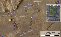
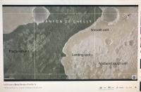
Hi Steve. They just had a press conference and image release on the mission website which includes this:
https://mars.nasa.gov/resources/25700/the-r...r-perseverance/ They will decide soon which of the two paths to take, but they seemed to prefer the clockwise path out of the landing area. Later it meets up with the nominal path through the delta. Phil -------------------- ... because the Solar System ain't gonna map itself.
Also to be found posting similar content on https://mastodon.social/@PhilStooke Maps for download (free PD: https://upload.wikimedia.org/wikipedia/comm...Cartography.pdf NOTE: everything created by me which I post on UMSF is considered to be in the public domain (NOT CC, public domain) |
|
|
|
|
Mar 6 2021, 01:41 AM
Post
#4
|
|
|
Member Group: Members Posts: 248 Joined: 25-February 21 From: Waltham, Massachussetts, U.S.A. Member No.: 8974 |
I have updated my interactive map using an EDL rover down look image with an animation of the first drive, estimated from closely analyzing the animation shown during the press conference:
https://bit.ly/PercyMAP Here is a map of the current location (ca. 4590880.87, 1093294.80, -2569.90, Equirectangular Mars 2000 Sphere projection):  I think it is pretty close. Rover should be to scale. [edit] Ah, I see that Phil came up earlier pretty much with the same route. Should have noticed earlier. Anyways, glad it was not a case famous last worlds. -------------------- --
Andreas Plesch, andreasplesch at gmail dot com |
|
|
|
|
Mar 6 2021, 04:50 AM
Post
#5
|
|
|
Member Group: Members Posts: 311 Joined: 31-August 05 From: Florida & Texas, USA Member No.: 482 |
QUOTE (Phil Stooke @ Mar 5 2021, 06:40 PM) Hi Steve. They just had a press conference and image release on the mission website which includes this: https://mars.nasa.gov/resources/25700/the-r...r-perseverance/ They will decide soon which of the two paths to take, but they seemed to prefer the clockwise path out of the landing area. Later it meets up with the nominal path through the delta. Phil The counter-clockwise route is a little shorter (~5km to delta front). The potential for science targets on the clockwise route seems like a better option even though it adds another km or so to reach the main delta. For instance, the isolated delta remnant would be reached in about 5km and it could be very useful to understanding delta formation and erosion. |
|
|
|
|
Mar 6 2021, 10:32 AM
Post
#6
|
|
|
Forum Contributor Group: Members Posts: 1372 Joined: 8-February 04 From: North East Florida, USA. Member No.: 11 |
QUOTE (Phil Stooke @ Mar 6 2021, 12:40 AM) Hi Steve. They just had a press conference and image release on the mission website which includes this: They will decide soon which of the two paths to take, but they seemed to prefer the clockwise path out of the landing area. Later it meets up with the nominal path through the delta. Phil They could have used different colours for the first part, I thought the blue and purple were the same colour when I watched the news briefing. |
|
|
|
|
Mar 6 2021, 10:42 AM
Post
#7
|
|
|
Forum Contributor Group: Members Posts: 1372 Joined: 8-February 04 From: North East Florida, USA. Member No.: 11 |
Why did they make the tread pattern curved and not just a straight line ?
|
|
|
|
|
Mar 6 2021, 11:11 AM
Post
#8
|
|
 Chief Assistant Group: Admin Posts: 1409 Joined: 5-January 05 From: Ierapetra, Greece Member No.: 136 |
Been wondering about that too. To make them stronger than straight lines would? Curiosity's were more like the design in most tires, but then inverted; raised rims instead of grooves.
-------------------- photographer, space imagery enthusiast, proud father and partner, and geek.
http://500px.com/sacred-photons & |
|
|
|
|
Mar 6 2021, 11:58 AM
Post
#9
|
|
|
Forum Contributor Group: Members Posts: 1372 Joined: 8-February 04 From: North East Florida, USA. Member No.: 11 |
QUOTE (Nix @ Mar 6 2021, 12:11 PM) Been wondering about that too. To make them stronger than straight lines would? Curiosity's were more like the design in most tires, but then inverted; raised rims instead of grooves. I found the answer : "Extensive testing in the Mars Yard at NASA's Jet Propulsion Laboratory, which built the rover and manages operations, has shown these treads better withstand the pressure from sharp rocks and grip just as well or better than Curiosity's when driving on sand." https://www.nasa.gov/feature/nasas-persever...-and-air-brakes |
|
|
|
|
Mar 6 2021, 12:48 PM
Post
#10
|
||
 Senior Member Group: Members Posts: 2430 Joined: 30-January 13 From: Penang, Malaysia. Member No.: 6853 |
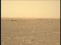
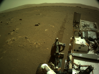
Another Sol, another drive (sol 15 Navcam - raw)
|
|
|
|
|
|
|
Mar 6 2021, 01:45 PM
Post
#11
|
|
|
Chief Assistant Group: Admin Posts: 1409 Joined: 5-January 05 From: Ierapetra, Greece Member No.: 136 |
QUOTE (MahFL @ Mar 6 2021, 01:58 PM) I found the answer : "Extensive testing in the Mars Yard at NASA's Jet Propulsion Laboratory, which built the rover and manages operations, has shown these treads better withstand the pressure from sharp rocks and grip just as well or better than Curiosity's when driving on sand." https://www.nasa.gov/feature/nasas-persever...-and-air-brakes I found as much; but nothing on straight vs curved specifically, only in comparison with the pattern on Curie's wheels. -------------------- photographer, space imagery enthusiast, proud father and partner, and geek.
http://500px.com/sacred-photons & |
|
|
|
|
Mar 6 2021, 02:13 PM
Post
#12
|
||
|
Junior Member Group: Members Posts: 75 Joined: 8-July 15 Member No.: 7566 |
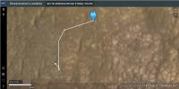
I made this map to show the two paths presented at yesterday's conference, my sense is that they'll decide fairly soon. Exciting times are ahead! The blue route is shorter (~4.6km, >23 sols drive) and safer, whereas the purple route is longer (~6.4km, >32 sols drive) but more scientifically interesting. The estimated times are based on the (aspirational?) 200m per sol that Percy has been designed to reach, of course in reality there'll be scientific stops that will greatly lengthen the journey. Personally, I am a fan of the purple route, it covers a greater diversity of geological terrains and gets a good close-up look at the amazing stratigraphy on the isolated delta butte. |
|
|
|
|
|
|
Mar 6 2021, 02:27 PM
Post
#13
|
||
|
Member Group: Members Posts: 102 Joined: 12-August 12 Member No.: 6540 |
QUOTE (Nix @ Mar 6 2021, 09:45 AM) I found as much; but nothing on straight vs curved specifically, only in comparison with the pattern on Curie's wheels. “But perhaps the most visible change is in the grousers. They are ten percent taller and run across the width of the wheel in a near straight line. It’s got a slight curvature to it to help give some strength to it,” says JPL engineer Patrick DeGrosse. https://www.sciencefriday.com/segments/to-b...s-test-on-mars/ Test wheel victims and survivors:
|
|
|
|
|
|
|
Mar 6 2021, 02:53 PM
Post
#14
|
|
|
Chief Assistant Group: Admin Posts: 1409 Joined: 5-January 05 From: Ierapetra, Greece Member No.: 136 |
Ah. Thanks
 . .
-------------------- photographer, space imagery enthusiast, proud father and partner, and geek.
http://500px.com/sacred-photons & |
|
|
|
|
Mar 6 2021, 03:15 PM
Post
#15
|
|
 Member Group: Members Posts: 291 Joined: 29-December 05 From: Ottawa, ON Member No.: 624 |
You'd think the Blue path would be more interesting with a large crater and the heat shield not far off the path that I'm certain the engineers would like to have a peek at.
|
|
|
|
|
Mar 6 2021, 03:30 PM
Post
#16
|
|
|
Senior Member Group: Members Posts: 2091 Joined: 13-February 10 From: Ontario Member No.: 5221 |
In the telecon yesterday they made clear that they will be staying away from any EDL hardware for contamination reasons.
We'd all like to see it, but Oppy's encounter was a confluence of circumstances. All the hardware was visible as soon as they left Eagle crater, the heat shield was right on the traverse path from Endurance crater, and there were far fewer concerns about close proximity negatively affecting the science mission. Look on the bright size; Mastcam-Z allows imaging at a distance with much more detail (if local topography allows), so no need to get super-close. |
|
|
|
|
Mar 6 2021, 03:36 PM
Post
#17
|
||
 Senior Member Group: Members Posts: 1089 Joined: 19-February 05 From: Close to Meudon Observatory in France Member No.: 172 |
QUOTE (Steve G @ Mar 6 2021, 04:15 PM) You'd think the Blue path would be more interesting with a large crater and the heat shield not far off the path that I'm certain the engineers would like to have a peek at. Yes for sure But also, like many, I would like a visit to see (even from a distance) the colorful parachute and its backshell. This would be a great opportunity for Education & Public Outreach and would offer the public great memorable pictures to see. And we will not have other opportunities to take such impressive pictures for decades to come
|
|
|
|
|
|
|
Mar 6 2021, 03:43 PM
Post
#18
|
|
|
Forum Contributor Group: Members Posts: 1372 Joined: 8-February 04 From: North East Florida, USA. Member No.: 11 |
QUOTE (Marvin @ Mar 6 2021, 03:27 PM) But perhaps the most visible change is in the grousers. They are ten percent taller and run across the width of the wheel in a near straight line. Its got a slight curvature to it to help give some strength to it, says JPL engineer Patrick DeGrosse. That Percy wheel looks pretty good for doing 60Km. |
|
|
|
|
Mar 6 2021, 04:43 PM
Post
#19
|
|
|
Member Group: Members Posts: 180 Joined: 31-January 05 From: Brittany (France) Member No.: 164 |
It seems Perseverance is now roughly 30 metres NNE of Octavia E. Butler site : the blue path is maybe already the chosen path.
-------------------- Erwann |
|
|
|
|
Mar 6 2021, 06:00 PM
Post
#20
|
||
|
Member Group: Members Posts: 180 Joined: 31-January 05 From: Brittany (France) Member No.: 164 |
I think here is approximately the location of Perseverance after sol 15 drive, marked in a sol 11 left mastcam Z image.
-------------------- Erwann |
|
|
|
|
|
|
Mar 6 2021, 06:12 PM
Post
#21
|
||
 Member Group: Members Posts: 816 Joined: 3-June 04 From: Brittany, France Member No.: 79 |
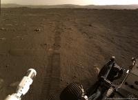
Picture taken by Navcam Right on sol 15 showing tracks left by tosol drive.
-------------------- |
|
|
|
|
|
|
Mar 6 2021, 06:34 PM
Post
#22
|
|
 Senior Member Group: Members Posts: 1887 Joined: 20-November 04 From: Iowa Member No.: 110 |
Why are they avoiding the area directly to the west?
|
|
|
|
|
Mar 6 2021, 06:41 PM
Post
#23
|
|
|
Member Group: Members Posts: 180 Joined: 31-January 05 From: Brittany (France) Member No.: 164 |
Alan, maybe they want to avoid sand dunes traverse ?
-------------------- Erwann |
|
|
|
|
Mar 6 2021, 06:48 PM
Post
#24
|
|
|
Senior Member Group: Members Posts: 2091 Joined: 13-February 10 From: Ontario Member No.: 5221 |
From the MRO images, it seems like there is room between the ripples to maneuver (it's not a solid field like what Curiosity had to go around to reach Mount Sharp), but presumably the team does not want to take even a small risk at this stage of the mission.
|
|
|
|
|
Mar 6 2021, 06:59 PM
Post
#25
|
||
|
Member Group: Members Posts: 102 Joined: 12-August 12 Member No.: 6540 |
Looks like they're sticking to the "Smooth Unit" and avoiding the "Fractured Unit".
|
|
|
|
|
|
|
Mar 6 2021, 07:39 PM
Post
#26
|
|
|
Member Group: Members Posts: 240 Joined: 18-July 06 Member No.: 981 |
QUOTE (Steve G @ Mar 6 2021, 04:15 PM) You'd think the Blue path would be more interesting with a large crater and the heat shield not far off the path that I'm certain the engineers would like to have a peek at. Definitely a "Blue" fan too. The crater is like an amphitheater with a view into the layer underlying the main delta. Also smoother driving and will let them make faster progress. I'd love to see photos of the heat shield in its new forever home even from a distance - good test of the zoom cams. |
|
|
|
|
Mar 6 2021, 08:37 PM
Post
#27
|
|
|
Solar System Cartographer Group: Members Posts: 10196 Joined: 5-April 05 From: Canada Member No.: 227 |
This is not the main traverse - they are looking for a place to drop the Belly Pan (which protected Ingenuity from the landing event), and will then return to a smooth area near the landing site to do the helicopter tests. Only after that will the main traverse begin.
Phil -------------------- ... because the Solar System ain't gonna map itself.
Also to be found posting similar content on https://mastodon.social/@PhilStooke Maps for download (free PD: https://upload.wikimedia.org/wikipedia/comm...Cartography.pdf NOTE: everything created by me which I post on UMSF is considered to be in the public domain (NOT CC, public domain) |
|
|
|
|
Mar 6 2021, 08:56 PM
Post
#28
|
||
|
Solar System Cartographer Group: Members Posts: 10196 Joined: 5-April 05 From: Canada Member No.: 227 |
In the absence of Navcam panoramas for each location I am using rather rough Hazcam reprojections to find the points to plot on the map. Here are the sol 14 and sol 15 images.
I think Erwan's site is very good. Phil
-------------------- ... because the Solar System ain't gonna map itself.
Also to be found posting similar content on https://mastodon.social/@PhilStooke Maps for download (free PD: https://upload.wikimedia.org/wikipedia/comm...Cartography.pdf NOTE: everything created by me which I post on UMSF is considered to be in the public domain (NOT CC, public domain) |
|
|
|
|
|
|
Mar 6 2021, 09:36 PM
Post
#29
|
||
|
Member Group: Members Posts: 180 Joined: 31-January 05 From: Brittany (France) Member No.: 164 |
QUOTE (Phil Stooke @ Mar 6 2021, 09:56 PM) In the absence of Navcam panoramas for each location I am using rather rough Hazcam reprojections to find the points to plot on the map. Here are the sol 14 and sol 15 images. I think Erwan's site is very good. Phil
Thank you Phi for your comment ; and there is also an helicopter... -------------------- Erwann |
|
|
|
|
|
|
Mar 7 2021, 03:06 AM
Post
#30
|
|
|
Member Group: Members Posts: 248 Joined: 25-February 21 From: Waltham, Massachussetts, U.S.A. Member No.: 8974 |
I have updated my interactive map based on EDL downlook at
http://bit.ly/PercyMAP with an animation showing the traverse. It is based on geojson path data from the Where is the rover page. The azimuth of the rover is following the path. That means that the first 150 degree turn is not represented. The way point geojson from the web page has additional yaw orientation data and shows for the current position a yaw of 88 degrees which I think corresponds to the front being pointed to the east. Is that what the latest camera images show ? Was there some turning in place on the final position of the last drive ? [edit] The answer was yes. But the traverse continued more on a 72 track. I updated again http://bit.ly/PercyMAP . -------------------- --
Andreas Plesch, andreasplesch at gmail dot com |
|
|
|
|
Mar 7 2021, 12:05 PM
Post
#31
|
||
|
Senior Member Group: Members Posts: 2430 Joined: 30-January 13 From: Penang, Malaysia. Member No.: 6853 |
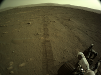
Sol 16, another drive
L-Navcam looking back at the latest set of wheel tracks on Mars...
|
|
|
|
|
|
|
Mar 7 2021, 12:16 PM
Post
#32
|
||
|
Member Group: Members Posts: 180 Joined: 31-January 05 From: Brittany (France) Member No.: 164 |
after the last sol 16 drive, Perseverance seems to be located here (marked on a mastcam Z sol 11 image)
-------------------- Erwann |
|
|
|
|
|
|
Mar 7 2021, 02:00 PM
Post
#33
|
||
|
Member Group: Members Posts: 102 Joined: 12-August 12 Member No.: 6540 |
Looks like the rover took a right turn during its Sol 16 drive:
https://mars.nasa.gov/mars2020/mission/where-is-the-rover/ |
|
|
|
|
|
|
Mar 7 2021, 04:34 PM
Post
#34
|
|
|
Member Group: Members Posts: 291 Joined: 29-December 05 From: Ottawa, ON Member No.: 624 |
If you've noticed the weird donut-shaped raw images on the Skycam, here is a great link on how it works.
https://www.hou.usra.edu/meetings/lpsc2020/eposter/2282.pdf |
|
|
|
|
Mar 7 2021, 06:40 PM
Post
#35
|
|
|
Merciless Robot Group: Admin Posts: 8784 Joined: 8-December 05 From: Los Angeles Member No.: 602 |
New helicopter thread established.
-------------------- A few will take this knowledge and use this power of a dream realized as a force for change, an impetus for further discovery to make less ancient dreams real.
|
|
|
|
|
Mar 7 2021, 09:15 PM
Post
#36
|
||
|
Solar System Cartographer Group: Members Posts: 10196 Joined: 5-April 05 From: Canada Member No.: 227 |
I am still trying to understand the Navcam geometry well enough to make panoramas. I put together a very simple one for sol 16 - horizon tier only - at low resolution. It's not perfect (not good enough to post) but good enough to make a circular view to check the sol 16 location on a HiRISE image. Only 5 Navcams are needed for a full panorama like this. It will be nice to see proper panoramas from our experts.
Phil
-------------------- ... because the Solar System ain't gonna map itself.
Also to be found posting similar content on https://mastodon.social/@PhilStooke Maps for download (free PD: https://upload.wikimedia.org/wikipedia/comm...Cartography.pdf NOTE: everything created by me which I post on UMSF is considered to be in the public domain (NOT CC, public domain) |
|
|
|
|
|
|
Mar 7 2021, 09:47 PM
Post
#37
|
||
|
Member Group: Members Posts: 180 Joined: 31-January 05 From: Brittany (France) Member No.: 164 |
QUOTE (Phil Stooke @ Mar 7 2021, 10:15 PM) I am still trying to understand the Navcam geometry well enough to make panoramas. I put together a very simple one for sol 16 - horizon tier only - al low resolution. It's not perfect (not good enough to post) but good enough to make a circular view to check the sol 16 location on a HiRISE image. Only 5 Navcams are needed for a full panorama like this. It will be nice to see proper panoramas from our experts. Phil Phil, it is good enough to refine the previous location i gave for sol 16 drive
-------------------- Erwann |
|
|
|
|
|
|
Mar 8 2021, 01:31 AM
Post
#38
|
|
|
Member Group: Members Posts: 248 Joined: 25-February 21 From: Waltham, Massachussetts, U.S.A. Member No.: 8974 |
Odometer
https://mars.nasa.gov/mmgis-maps/M20/Layers...0_traverse.json has the traverse geojson data which are used on the Where is Perseverance ? map. The json data also include distances traveled per leg. In addition, it is possible to determine travel distance by measuring along the provided coordinates. Here is a table: CODE day: geojson measured sol 14: 6.25 6.38 sol 15: 36.39 36.53 sol 16: 27.43 28.78 All in meters. There is a small difference and I am not sure why. In any case, total travel sofar is 70m to 72m. -------------------- --
Andreas Plesch, andreasplesch at gmail dot com |
|
|
|
|
Mar 8 2021, 03:00 AM
Post
#39
|
|
|
Member Group: Members Posts: 362 Joined: 13-April 06 From: Malta Member No.: 741 |
Has it been decided where to send the rover on a north or south route?
|
|
|
|
|
Mar 8 2021, 04:12 AM
Post
#40
|
|
|
Solar System Cartographer Group: Members Posts: 10196 Joined: 5-April 05 From: Canada Member No.: 227 |
No. Helicopter operations come before the main traverse.
Phil -------------------- ... because the Solar System ain't gonna map itself.
Also to be found posting similar content on https://mastodon.social/@PhilStooke Maps for download (free PD: https://upload.wikimedia.org/wikipedia/comm...Cartography.pdf NOTE: everything created by me which I post on UMSF is considered to be in the public domain (NOT CC, public domain) |
|
|
|
|
Mar 8 2021, 10:58 AM
Post
#41
|
|
|
Senior Member Group: Members Posts: 2430 Joined: 30-January 13 From: Penang, Malaysia. Member No.: 6853 |
QUOTE (Andreas Plesch @ Mar 8 2021, 09:31 AM) Andreas, Nice link for the traverse path JSON. Many thanks I notice your animated traverse that you show elevation of the terrain around the rover. Perseverance elevation data is not available in the M20 interactive map geojson files, so I was wondering if you are aware of any external links to the other M20 traverse values such as pitch, roll etc values and especially elevation at each coordinate change that is made available in the Curiosity Rover interactive map geojson files? Elevation is not hugely interesting in this near flat plain, but it will be of great interest as the rover begins to climb onto the delta and beyond. Any links would be very welcome. regards, Paul |
|
|
|
|
Mar 8 2021, 03:24 PM
Post
#42
|
|
|
Member Group: Members Posts: 248 Joined: 25-February 21 From: Waltham, Massachussetts, U.S.A. Member No.: 8974 |
QUOTE (PaulH51 @ Mar 8 2021, 05:58 AM) Andreas, Nice link for the traverse path JSON. Many thanks I notice your animated traverse that you show elevation of the terrain around the rover. Perseverance elevation data is not available in the M20 interactive map geojson files, so I was wondering if you are aware of any external links to the other M20 traverse values such as pitch, roll etc values and especially elevation at each coordinate change that is made available in the Curiosity Rover interactive map geojson files? Elevation is not hugely interesting in this near flat plain, but it will be of great interest as the rover begins to climb onto the delta and beyond. Any links would be very welcome. regards, Paul The Where is the rover map uses a few more geojson files, see http://www.unmannedspaceflight.com/index.p...st&p=250647 . The way points geojson has yaw, pitch roll data. I just learned about the PDS PLACES database: http://www.unmannedspaceflight.com/index.p...st&p=250716 I think the geojson comes directly from there. There should be elevation (or Z data) but it is not provided in the geojson. I use the 1m HiRISE mosaic DEM linked from: https://astrogeology.usgs.gov/search/map/Ma...tTs0_lon0_first for querying elevation. The DEM and the imagery should be very well co-registered. In my animated traverse due to slight 3d perspective viewing the rover appears a little offset from the traverse since it is offset above ground level. If the geojson included elevation, I could use that as well. Regarding the odometer data, the distances from the geojson may be straight from the rover, using wheel rotations although the coordinates may also be straight from the rover (with subsequent conversion to latitude/longitude). I used projected, equirectangular coordinates to measure distances which is strictly speaking not quite correct but probably still ok at 18 degrees latitude. In any case, it could not explain a >1m discrepancy in distances. Perhaps the geojson distance is the straight line distance between way points, not along the path but this is inconsistent with the last leg which is almost perfectly straight and has the largest difference. -------------------- --
Andreas Plesch, andreasplesch at gmail dot com |
|
|
|
|
Mar 8 2021, 08:04 PM
Post
#43
|
||
|
Member Group: Members Posts: 102 Joined: 12-August 12 Member No.: 6540 |
The Sol 17 raw images are online. There's a lot of images of the robotic arm.
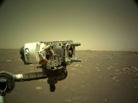
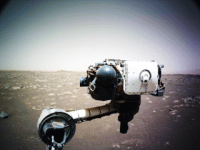
Here's a good image of the business end of the arm, the coring drill, framed by a Martian landscape:
|
|
|
|
|
|
|
Mar 9 2021, 12:57 AM
Post
#44
|
||
|
Senior Member Group: Members Posts: 2430 Joined: 30-January 13 From: Penang, Malaysia. Member No.: 6853 |
Looks like we have arrived at a candidate Helipad. This posted on social media.
QUOTE Ive continued driving to scout a spot where Ill drop off the Mars Helicopter, if the area gets certified as a flight zone. So far, about 230 feet (70 meters) of wheel tracks behind me.
|
|
|
|
|
|
|
Mar 9 2021, 01:08 AM
Post
#45
|
||
|
Member Group: Members Posts: 248 Joined: 25-February 21 From: Waltham, Massachussetts, U.S.A. Member No.: 8974 |
The arm got a workout for each axis. Click to animate:
has a color equalize for each frame (the blueish sky is not real). -------------------- --
Andreas Plesch, andreasplesch at gmail dot com |
|
|
|
|
|
|
Mar 9 2021, 01:44 AM
Post
#46
|
||
|
Member Group: Members Posts: 808 Joined: 10-October 06 From: Maynard Mass USA Member No.: 1241 |
Here is MEDIA SkyCam
Sol 16, 8 AM Local There is dust on the lens (and some hot pixels) (animated gif)
(and is that Wall-E peeking in ...) -------------------- CLA CLL
|
|
|
|
|
|
|
Mar 9 2021, 05:35 AM
Post
#47
|
|
 Senior Member Group: Members Posts: 4252 Joined: 17-January 05 Member No.: 152 |
And in this deeper exposure taken at a similar time we can see the sun through the neutral-density annulus:
https://mars.nasa.gov/mars2020-raw-images/p...5_0000LUJ01.png |
|
|
|
|
Mar 9 2021, 07:17 PM
Post
#48
|
||
|
Solar System Cartographer Group: Members Posts: 10196 Joined: 5-April 05 From: Canada Member No.: 227 |
This is an illustration of the map offset mentioned earlier. The color HiRISE image with the route map from the website registered to it. The third panel shows them superimposed. The map's starting location is too close to the drifts behind the rover and should be moved roughly 3 m southeast (north is at the top, except I registered the map to HiRISE when I should have done the reverse, so north is really a bit clockwise from the top).
Phil
-------------------- ... because the Solar System ain't gonna map itself.
Also to be found posting similar content on https://mastodon.social/@PhilStooke Maps for download (free PD: https://upload.wikimedia.org/wikipedia/comm...Cartography.pdf NOTE: everything created by me which I post on UMSF is considered to be in the public domain (NOT CC, public domain) |
|
|
|
|
|
|
Mar 9 2021, 07:53 PM
Post
#49
|
|
|
Member Group: Members Posts: 248 Joined: 25-February 21 From: Waltham, Massachussetts, U.S.A. Member No.: 8974 |
http://bit.ly/PercyCOORDs (from http://www.unmannedspaceflight.com/index.p...t&p=250266)
shows the landing location as I had read it from the online map right when it was shown first, and the actual landing location imaged from orbit. The online map coordinates then showed as 77.45081, 18.44468 This now seems different and corrected on the online map, and they show as, and the geojson has them as: 77.45088572, 18.44462715 But, and I would confirm Phil, this is still a little offset from what the registered HiRISE of the landed rover shows. For me it comes out at 77.4508882°E, 18.4446394°N , CRS: EPSG 104971 - Mars 2000 (Sphere) The differences are small but I think real and indicate some kind of positioning/registration mismatches. On the other hand subsequent way point locations from the geojson look really close to what navcam imaging reveals, relative to close boulders. But I did not attempt any direct comparisons for those. -------------------- --
Andreas Plesch, andreasplesch at gmail dot com |
|
|
|
|
Mar 10 2021, 12:06 AM
Post
#50
|
|
|
Solar System Cartographer Group: Members Posts: 10196 Joined: 5-April 05 From: Canada Member No.: 227 |
I just noticed that when you let the cursor roll over the traverse on the 'where is the rover' map, it pops up with the length of the drive. I don't know if I just missed that before or if it's new. Roll over the site and you get the sol on which the rover reached that point - it has done that since the landing. If that works for Curiosity as well, it makes up for the loss of drive distance which Paul was concerned about.
Phil -------------------- ... because the Solar System ain't gonna map itself.
Also to be found posting similar content on https://mastodon.social/@PhilStooke Maps for download (free PD: https://upload.wikimedia.org/wikipedia/comm...Cartography.pdf NOTE: everything created by me which I post on UMSF is considered to be in the public domain (NOT CC, public domain) |
|
|
|
|
Mar 10 2021, 01:26 AM
Post
#51
|
|
|
Senior Member Group: Members Posts: 2430 Joined: 30-January 13 From: Penang, Malaysia. Member No.: 6853 |
QUOTE (Phil Stooke @ Mar 10 2021, 08:06 AM) I just noticed that when you let the cursor roll over the traverse on the 'where is the rover' map, it pops up with the length of the drive. I don't know if I just missed that before or if it's new. Roll over the site and you get the sol on which the rover reached that point - it has done that since the landing. If that works for Curiosity as well, it makes up for the loss of drive distance which Paul was concerned about. Phil Mouse over has worked from the onset on paths, it also works on the sol markers. Zoom in close on the M20 map, you can select the individual paths, once selected the path length is displayed on the top of the page, click a sol marker and the sol/waypoint number is displayed instead. Presently the MSL map mouse over, and clicking a sol marker works as M20. Mouse over or clicking the path displays this caption 'from_SCLK:0'. The maps appear to get those captions from the geojson fields that are readily exportable from the map menu. I really enjoy using these new maps, and especially the additional json data available in the M20 map like roll and pitch and the path length is wonderful. Hopefully they'll provide the same level of details on both maps one day, I know it's there in JSON files in NAIF / SPICE for those that know how to get it, but that's probably not the best way to excite the public who use these maps. |
|
|
|
|
Mar 11 2021, 12:51 AM
Post
#52
|
|
|
Member Group: Members Posts: 248 Joined: 25-February 21 From: Waltham, Massachussetts, U.S.A. Member No.: 8974 |
Apart from the ZCam image I found two more images of the Yeehgo Supercam target.
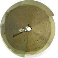
One Navcam image from a distance:  The location relative to boulder, pediment and dune landmarks corresponds exactly to what Phil shows on the latest map. And one Hazcam image from close range which gives another perspective of the shape of the block, as quite blocky:  -------------------- --
Andreas Plesch, andreasplesch at gmail dot com |
|
|
|
|
Mar 11 2021, 05:31 AM
Post
#53
|
|
|
Junior Member Group: Members Posts: 31 Joined: 10-August 12 Member No.: 6526 |
QUOTE (PDP8E @ Mar 8 2021, 05:44 PM) Here is MEDIA SkyCam Sol 16, 8 AM Local There is dust on the lens (and some hot pixels) Seems like quite a few hot pixels. I know my cameras' sensors get more hot pixels as they age. This cam is supposed to be a spare Hazcam from MSL so it's already got an extra 8 years on it, not to mention journey through space, so I guess it makes sense. Mark |
|
|
|
|
Mar 11 2021, 10:54 AM
Post
#54
|
|
|
Junior Member Group: Members Posts: 95 Joined: 11-January 07 From: Amsterdam Member No.: 1584 |
-------------------- |
|
|
|
|
Mar 11 2021, 10:19 PM
Post
#55
|
||
|
Senior Member Group: Members Posts: 2430 Joined: 30-January 13 From: Penang, Malaysia. Member No.: 6853 |
And another drive on Sol 20 as seen in this L-Navcam frame looking back at the tracks.
The map has not been updated yet, so unsure of the location. Not sure if this means the that candidate helipad (sol 16) was not suitable, or possibly they are just continuing to scout the area We may find out more in 'The von Kármán Lecture Series: Helicopters in Space' link? Scheduled in a few hours: March 11, Time: 7 p.m. PDT (10 p.m. EDT; 0300 UTC)
|
|
|
|
|
|
|
Mar 12 2021, 12:20 AM
Post
#56
|
||
|
Solar System Cartographer Group: Members Posts: 10196 Joined: 5-April 05 From: Canada Member No.: 227 |
This is the sol 20 panorama in circular form, Looks like the drive was towards the southwest. My rough and ready panorama is not good enough to post, I will wait for experts to start doing them properly.
Phil
-------------------- ... because the Solar System ain't gonna map itself.
Also to be found posting similar content on https://mastodon.social/@PhilStooke Maps for download (free PD: https://upload.wikimedia.org/wikipedia/comm...Cartography.pdf NOTE: everything created by me which I post on UMSF is considered to be in the public domain (NOT CC, public domain) |
|
|
|
|
|
|
Mar 12 2021, 02:50 PM
Post
#57
|
||
|
Senior Member Group: Members Posts: 2430 Joined: 30-January 13 From: Penang, Malaysia. Member No.: 6853 |
Sol 21 SHERLOC Mosaic (de-Bayer) and assembled in MS-ICE.
Looking at the thumbnails, there's a lot more on the way, but I felt this was worth sharing now
|
|
|
|
|
|
|
Mar 12 2021, 03:20 PM
Post
#58
|
||
|
Junior Member Group: Members Posts: 95 Joined: 11-January 07 From: Amsterdam Member No.: 1584 |
QUOTE (PaulH51 @ Mar 12 2021, 03:50 PM) Sol 21 SHERLOC Mosaic (de-Bayer) and assembled in MS-ICE. Looking at the thumbnails, there's a lot more on the way, but I felt this was worth sharing now
That's an awesome perspective! Nice work! -------------------- |
|
|
|
|
|
|
Mar 12 2021, 05:47 PM
Post
#59
|
|
|
Member Group: Members Posts: 923 Joined: 10-November 15 Member No.: 7837 |
Nice work Paul!
Percy is about to lay a very special egg. 
-------------------- |
|
|
|
|
Mar 12 2021, 06:37 PM
Post
#60
|
|
|
Member Group: Members Posts: 816 Joined: 3-June 04 From: Brittany, France Member No.: 79 |
Nice work Paul and Sean! Here is my take on this underbelly mosaic.

-------------------- |
|
|
|
|
Mar 12 2021, 07:05 PM
Post
#61
|
|
|
Member Group: Members Posts: 102 Joined: 12-August 12 Member No.: 6540 |
The underbelly mosaics are great!
Perseverance looks like she's ready to pop. I am expectantly awaiting Ingenuity to take its first baby flights Also, from twitter, they are getting ready to drop the sample caching system belly pan. |
|
|
|
|
Mar 12 2021, 09:08 PM
Post
#62
|
|
|
Member Group: Members Posts: 816 Joined: 3-June 04 From: Brittany, France Member No.: 79 |
Since the focus is on WATSON camera with the belly mosaic, I made a composition with a Navcam Left and Mastcam-Z Left pictures of WATSON taken on sol 17.

-------------------- |
|
|
|
|
Mar 13 2021, 12:46 PM
Post
#63
|
||
 Senior Member Group: Members Posts: 1444 Joined: 26-July 08 Member No.: 4270 |
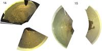
The drop has occurred.
Attached thumbnail(s)
-------------------- -- Hungry4info (Sirius_Alpha)
|
|
|
|
|
|
|
Mar 13 2021, 02:11 PM
Post
#64
|
||
|
Senior Member Group: Members Posts: 2430 Joined: 30-January 13 From: Penang, Malaysia. Member No.: 6853 |
Here's my rough and ready mosaic of the 8 overlapping frames of the Sol 22 ejected Belly Pan that protected the sampling system bay during the later part of EDL.
De-Bayer (GIMP) stitched (MS-ICE)
|
|
|
|
|
|
|
Mar 13 2021, 03:17 PM
Post
#65
|
|
|
Forum Contributor Group: Members Posts: 1372 Joined: 8-February 04 From: North East Florida, USA. Member No.: 11 |
QUOTE (PaulH51 @ Mar 13 2021, 02:11 PM) Here's my rough and ready mosaic of the 8 overlapping frames of the Sol 22 ejected Belly Pan that protected the sampling system bay during the later part of EDL. De-Bayer (GIMP) stitched (MS-ICE) I did not know there was a cover on the sample handling system, no one ever mentioned that in any of the briefings I saw. |
|
|
|
|
Mar 13 2021, 03:21 PM
Post
#66
|
||
|
Member Group: Members Posts: 816 Joined: 3-June 04 From: Brittany, France Member No.: 79 |
Before/after animation of the belly pan ejection on sol 22.
There are a lot of dust specks on the WATSON optic, and a big one. I removed them one by one, next step is to write a script that do it automatically. -------------------- |
|
|
|
|
|
|
Mar 13 2021, 04:37 PM
Post
#67
|
|
 Senior Member Group: Members Posts: 1619 Joined: 12-February 06 From: Bergerac - FR Member No.: 678 |
Very instructive animation Thomas
Mines are static pictures, taken on Sol 21 & 22. 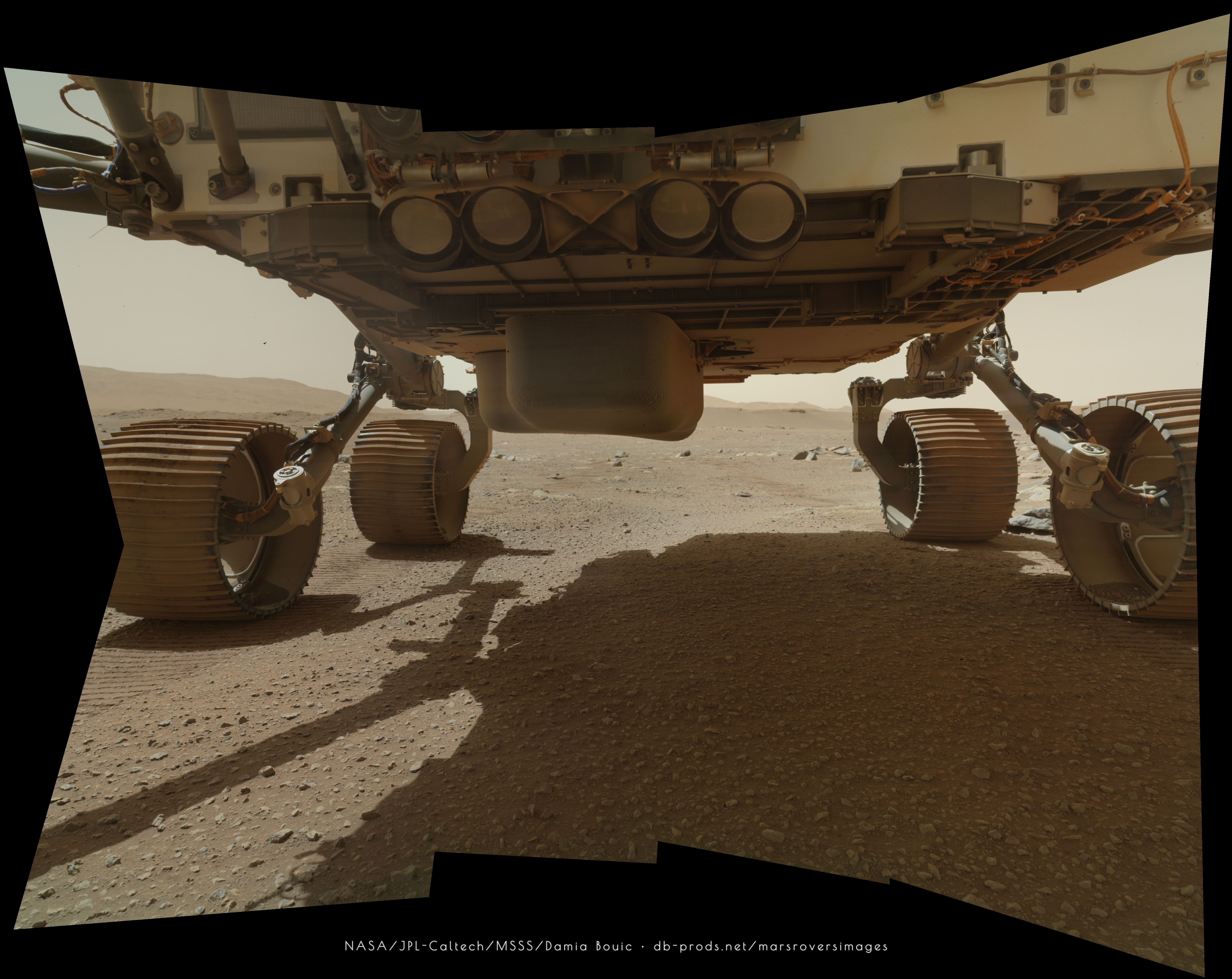 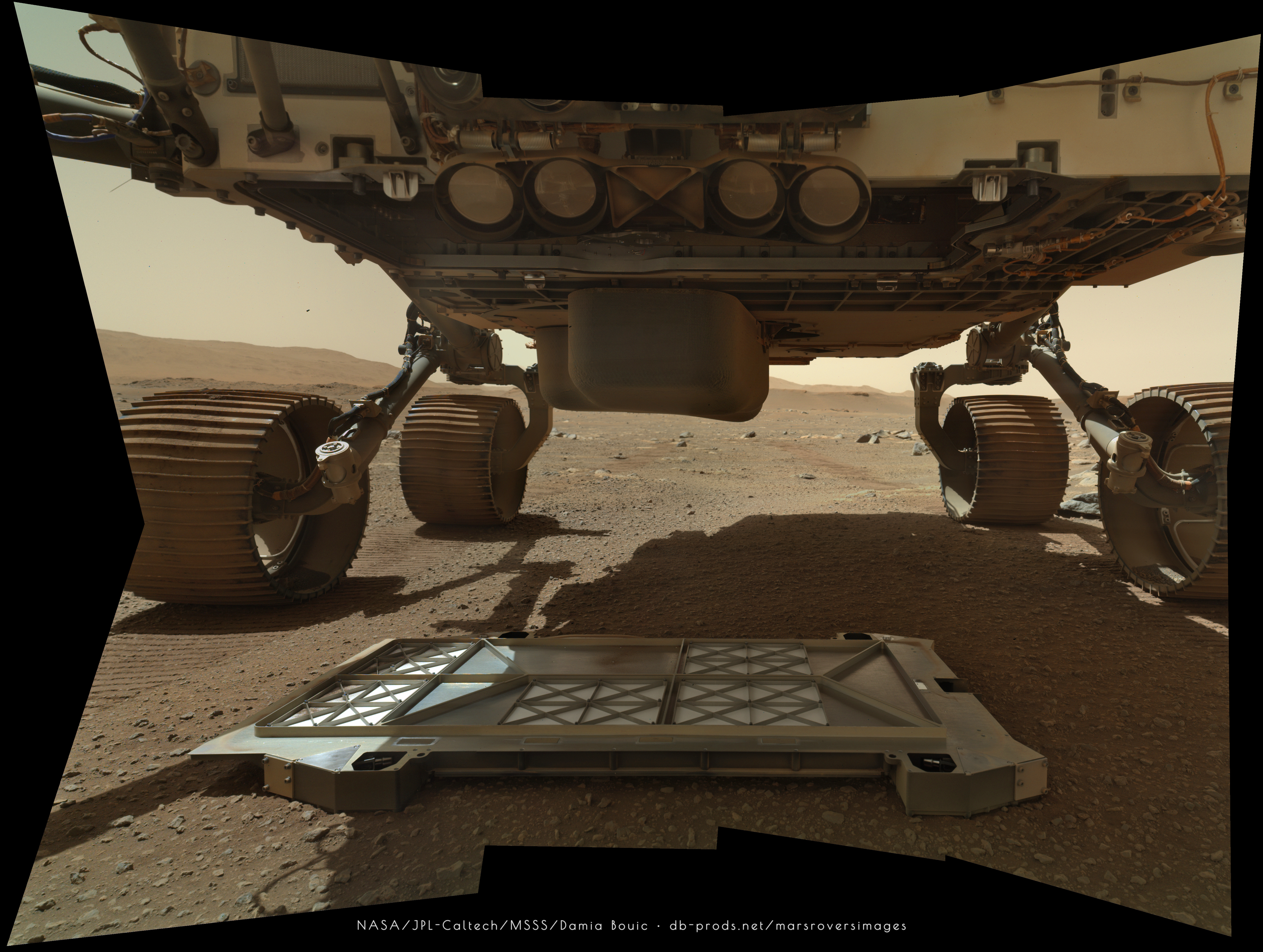
-------------------- |
|
|
|
|
Mar 13 2021, 06:00 PM
Post
#68
|
|||
|
Member Group: Members Posts: 102 Joined: 12-August 12 Member No.: 6540 |
We got a peek at part of the sampling and caching system:
From this diagram, it looks like the DVT assembly:
Source: https://esmats.eu/amspapers/pastpapers/pdfs...0/silverman.pdf |
||
|
|
|
||
|
Mar 13 2021, 06:27 PM
Post
#69
|
|
 Senior Member Group: Members Posts: 2530 Joined: 20-April 05 Member No.: 321 |
I hope I get to see one of those tubes in a museum one day! (Or any other state of affairs that entails their safe return.)
|
|
|
|
|
Mar 13 2021, 08:11 PM
Post
#70
|
|
 Member Group: Members Posts: 146 Joined: 22-November 14 From: Bormida (SV) - Italy Member No.: 7348 |
Before ...
 and after  really, I'm hoping it opened the other box  EDIT: However I realized that we are looking at the reflection of the pipes only after the de-bayer .... 
-------------------- |
|
|
|
|
Mar 14 2021, 01:13 AM
Post
#71
|
|
|
Member Group: Members Posts: 248 Joined: 25-February 21 From: Waltham, Massachussetts, U.S.A. Member No.: 8974 |
QUOTE (Andreas Plesch @ Mar 7 2021, 08:31 PM) Odometer https://mars.nasa.gov/mmgis-maps/M20/Layers...0_traverse.json has the traverse geojson data which are used on the Where is Perseverance ? map. The json data also include distances traveled per leg. In addition, it is possible to determine travel distance by measuring along the provided coordinates. Here is a table: CODE day: geojson measured sol 14: 6.25 6.38 sol 15: 36.39 36.53 sol 16: 27.43 28.78 All in meters. There is a small difference and I am not sure why. In any case, total travel sofar is 70m to 72m. I think the difference is explained by the geojson using true meters for easting, and the measured distance projected map meters. True meters are 0.94863 map meters at this latitude, in easting. -------------------- --
Andreas Plesch, andreasplesch at gmail dot com |
|
|
|
|
Mar 14 2021, 02:11 AM
Post
#72
|
|
|
Member Group: Members Posts: 248 Joined: 25-February 21 From: Waltham, Massachussetts, U.S.A. Member No.: 8974 |
I updated this animated, interactive map with way points, a contrast control, and latitude adjusted distances:
https://bit.ly/PercyMAP Double click to recenter, middle button to pan, right button or wheel to zoom. The rover is to scale, the blue way points are transparent and 2m in diameter. -------------------- --
Andreas Plesch, andreasplesch at gmail dot com |
|
|
|
|
Mar 14 2021, 03:20 AM
Post
#73
|
|
|
Solar System Cartographer Group: Members Posts: 10196 Joined: 5-April 05 From: Canada Member No.: 227 |
Maybe, but I find that disturbing. There should only be one kind of meter. It's the length of a degree of longitude which should vary with latitude.
I will look into the difference between planetocentric and planetographic coordinates... Phil -------------------- ... because the Solar System ain't gonna map itself.
Also to be found posting similar content on https://mastodon.social/@PhilStooke Maps for download (free PD: https://upload.wikimedia.org/wikipedia/comm...Cartography.pdf NOTE: everything created by me which I post on UMSF is considered to be in the public domain (NOT CC, public domain) |
|
|
|
|
Mar 14 2021, 04:15 AM
Post
#74
|
|
|
Member Group: Members Posts: 248 Joined: 25-February 21 From: Waltham, Massachussetts, U.S.A. Member No.: 8974 |
QUOTE (Phil Stooke @ Mar 13 2021, 10:20 PM) Maybe, but I find that disturbing. There should only be one kind of meter. It's the length of a degree of longitude which should vary with latitude. I will look into the difference between planetocentric and planetographic coordinates... Phil Thanks. I think their map meters would be normally the actual easting (keeping in mind that the extremely simple projection is not suited for measuring distances), and their true meters would be something like an adjusted easting. In fact, actually choosing a standard parallel at the regional latitude (say at 18 degrees N) would make the projection more tolerable to use, with less distortions as well as good scale for easting. I think their conversion between map and true meters is similar to, or perhaps even equivalent to choosing a standard parallel at the actual latitude. -------------------- --
Andreas Plesch, andreasplesch at gmail dot com |
|
|
|
|
Mar 14 2021, 04:23 AM
Post
#75
|
|
 Member Group: Members Posts: 445 Joined: 1-July 05 From: New York City Member No.: 424 |
And here I thought that a meter was the length of a platinum bar kept in Napoleon's tomb.
 Seriously though, I guess you're not using "meter" to mean a fixed length? There seems to be potential for confusion ... |
|
|
|
|
Mar 14 2021, 12:34 PM
Post
#76
|
|
|
Member Group: Members Posts: 248 Joined: 25-February 21 From: Waltham, Massachussetts, U.S.A. Member No.: 8974 |
QUOTE (Tom Tamlyn @ Mar 13 2021, 11:23 PM) And here I thought that a meter was the length of a platinum bar kept in Napoleon's tomb. Seriously though, I guess you're not using "meter" to mean a fixed length? There seems to be potential for confusion ... Yes, it is confusing. I was just following the nomenclature and discussion of section 3.9.2 in https://pds-imaging.jpl.nasa.gov/data/msl/M...CES_PDS_SIS.PDF See http://www.unmannedspaceflight.com/index.p...st&p=250931 -------------------- --
Andreas Plesch, andreasplesch at gmail dot com |
|
|
|
|
Mar 14 2021, 01:24 PM
Post
#77
|
||
|
Senior Member Group: Members Posts: 2430 Joined: 30-January 13 From: Penang, Malaysia. Member No.: 6853 |
A short drive away from the ejected belly pan, then a turn in place during sol 23
|
|
|
|
|
|
|
Mar 14 2021, 05:43 PM
Post
#78
|
|
|
Member Group: Members Posts: 445 Joined: 1-July 05 From: New York City Member No.: 424 |
QUOTE (Andreas Plesch @ Mar 14 2021, 07:34 AM) Yes, it is confusing. I was just following the nomenclature and discussion of section 3.9.2 in https://pds-imaging.jpl.nasa.gov/data/msl/M...CES_PDS_SIS.PDF Ahh. QUOTE 3.9.2. Projected Meters vs. True Meters It is important to note that the east/west measurement, called easting, is defined by meters at the equator. Orbital images as used by the MSL localization science team, and thus by PLACES, use a rectangular projection, so that lines of longitude are parallel (as are lines of latitude, naturally). For convenience there are an equal number of meters between each line of longitude, regardless of latitude. This greatly simplifies calculations, and as a nice side-effect causes site frames to be parallel in the orbital projection **** It should be noted that the rover works only with true meters, and does not take into account planet curvature. Thus the telemetry view (and only the telemetry view) is actually expressed in true meters, and assumes a flat world. The localization error in telemetry, even with visual odometry turned on, is far greater than the true vs. easting meters difference, so in practice this distinction makes no difference. Hmm. That's helpful, in that I now dimly grok what's going on. I seem to recall from that whimsical novel Flatland that the reaction of the animate geometrical figures to the idea of additional dimensions was irritable disbelief, and my emotional reaction is similar -- when I think about concepts of length, I want to assume a flat world. Thanks very much! |
|
|
|
|
Mar 14 2021, 06:15 PM
Post
#79
|
|
|
Member Group: Members Posts: 923 Joined: 10-November 15 Member No.: 7837 |

-------------------- |
|
|
|
|
Mar 14 2021, 09:39 PM
Post
#80
|
|
 Member Group: Members Posts: 559 Joined: 1-May 06 From: Scotland (Ecosse, Escocia) Member No.: 759 |
I wonder of the dust inside that panel, on the right, penetrated the seal during landing blast, or bounced in there during panel jettison, or came from the wheels driving past?
|
|
|
|
|
Mar 15 2021, 02:56 PM
Post
#81
|
|
 Junior Member Group: Members Posts: 73 Joined: 10-May 06 From: Spain Member No.: 770 |
QUOTE (Sean @ Mar 14 2021, 07:15 PM) Excellent. How to get the colors? |
|
|
|
|
Mar 15 2021, 04:25 PM
Post
#82
|
|
|
Member Group: Members Posts: 157 Joined: 22-May 09 From: Ireland Member No.: 4792 |
Just a simple, experimental look at the impact dynamics of the pan with the surface on the pebbles from a macroscale level, at bottom-right.
As the impact caused three small pebbles to be shifted (well, at least three easily viewable ones amongst others too small to see), I wonder are the two blue-high-lighted ones, in left view (before impact), those two same ones on the right (after impact). As to which or where the orange-highlighted pebble originated from is, in the before impact view, anyone's guess. John 
|
|
|
|
|
Mar 15 2021, 05:55 PM
Post
#83
|
|
|
Senior Member Group: Members Posts: 2530 Joined: 20-April 05 Member No.: 321 |
Fun mystery, John. I think I may see the origin of the orange pebble. In Image 1, there is what seems to be a smaller, bright, triangular pebble above (at the 1 o'clock position of) the leftmost of the two blue pebbles. I think the deployment of the hardware rearranged the soil and unearthed that pebble from a mainly-buried state to a mainly-exposed one.
|
|
|
|
|
Mar 15 2021, 07:45 PM
Post
#84
|
|
|
Member Group: Members Posts: 157 Joined: 22-May 09 From: Ireland Member No.: 4792 |
Cheers, JRehling...you could be right.
Thomas Appéré's animation above, at a zoomed-in view of the pan's right-hand corner, shows the pebble 'jumps' nicely. There also is another 'jumping pebble' (yeah, the term might catch on  ) examples on the pan's ) examples on the pan's bottom-left corner area, too. John |
|
|
|
|
Mar 16 2021, 12:57 AM
Post
#85
|
||
|
Forum Contributor Group: Members Posts: 1372 Joined: 8-February 04 From: North East Florida, USA. Member No.: 11 |
They opened a cover on the sample receiving part on the rover, does this cover remain permanently open ?
Attached thumbnail(s)
|
|
|
|
|
|
|
Mar 16 2021, 02:12 AM
Post
#86
|
|
|
Senior Member Group: Members Posts: 2430 Joined: 30-January 13 From: Penang, Malaysia. Member No.: 6853 |
QUOTE (MahFL @ Mar 16 2021, 08:57 AM) They opened a cover on the sample receiving part on the rover, does this cover remain permanently open ? If I'm understanding this document correctly, then it's a 'one-time deployment door'. QUOTE The bit carousel (BC) assembly contains an upper and lower opening in its structure. The lower entry point allows for sample tubes to be inserted into bits for sample acquisition, as well as removal from a bit once a sample has been collected (Figure 8). The upper entry point supports bit exchange operations with the Corer assembly. Both of these openings utilize a one-time deployment door to maintain cleanliness of the hardware within the BC until release on the surface of Mars. Both doors consist of a passive spring-actuated hinge mechanism held closed by a latch that is deployed via a release mechanism. The release mechanism is a series of passive spring-actuated mechanisms initiated by a separation nut non-explosive actuator (NEA) device from Ensign-Bickford Aerospace & Defense Company.
|
|
|
|
|
Mar 16 2021, 02:12 AM
Post
#87
|
|
|
Member Group: Members Posts: 248 Joined: 25-February 21 From: Waltham, Massachussetts, U.S.A. Member No.: 8974 |
I have updated my animated map of the drive with the latest move. The segment from the last to the current way point does not have intermediate points in the geojson, unlike the previous segments. That is why it looks accelerated. On the technical side, I automated getting the traverse and converting it to the animation, as well as plotting the way points. So, if the the format of the source geojson does not change, the link should auto-update after new drives, at the same time when the Where is Perseverance map updates. I also added a perspective view (NORTH) which may be helpful in getting a sense of the subtle topography.
double click to recenter, middle button to pan, right button or wheel to zoom. There is a RESET button to the rescue if you get lost. -------------------- --
Andreas Plesch, andreasplesch at gmail dot com |
|
|
|
|
Mar 16 2021, 09:13 AM
Post
#88
|
|
|
Senior Member Group: Members Posts: 1619 Joined: 12-February 06 From: Bergerac - FR Member No.: 678 |
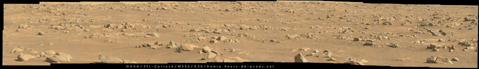
Sol 22 MZ mosaic @110mm. Very rocky terrain ahead !
-------------------- |
|
|
|
|
Mar 16 2021, 12:48 PM
Post
#89
|
||
|
Member Group: Members Posts: 102 Joined: 12-August 12 Member No.: 6540 |
QUOTE (MahFL @ Mar 15 2021, 07:57 PM) They opened a cover on the sample receiving part on the rover, does this cover remain permanently open ? This document also says it's a "one-time release door": https://sites.nationalacademies.org/cs/grou.../ssb_180772.pdf It seems counter-intuitive to have an open hole allowing dust to be blown into the rover. Internally, the rotating carousel looks like this:
The literature says there are nine different drilling bits (in blue). Maybe the gray one at around 3 o'clock is null or closed, rotated to this position when not in use? |
|
|
|
|
|
|
Mar 16 2021, 06:27 PM
Post
#90
|
|
|
Solar System Cartographer Group: Members Posts: 10196 Joined: 5-April 05 From: Canada Member No.: 227 |
News from LPSC: I just asked Roger Wiens if the Supercam images will be available on Raw Images - yes. starting in a few days.
Phil -------------------- ... because the Solar System ain't gonna map itself.
Also to be found posting similar content on https://mastodon.social/@PhilStooke Maps for download (free PD: https://upload.wikimedia.org/wikipedia/comm...Cartography.pdf NOTE: everything created by me which I post on UMSF is considered to be in the public domain (NOT CC, public domain) |
|
|
|
|
Mar 16 2021, 06:28 PM
Post
#91
|
|
|
Solar System Cartographer Group: Members Posts: 10196 Joined: 5-April 05 From: Canada Member No.: 227 |
Damia's rocky panorama just above is identified at LPSC as a candidate for the rover parking area during helicopter operations.
Phil -------------------- ... because the Solar System ain't gonna map itself.
Also to be found posting similar content on https://mastodon.social/@PhilStooke Maps for download (free PD: https://upload.wikimedia.org/wikipedia/comm...Cartography.pdf NOTE: everything created by me which I post on UMSF is considered to be in the public domain (NOT CC, public domain) |
|
|
|
|
Mar 16 2021, 11:23 PM
Post
#92
|
|
 Martian Photographer Group: Members Posts: 352 Joined: 3-March 05 Member No.: 183 |
|
|
|
|
|
Mar 17 2021, 12:08 AM
Post
#93
|
|
|
Solar System Cartographer Group: Members Posts: 10196 Joined: 5-April 05 From: Canada Member No.: 227 |
Is that sol 18? Looking for the images.
EDIT: given above - thanks! Phil -------------------- ... because the Solar System ain't gonna map itself.
Also to be found posting similar content on https://mastodon.social/@PhilStooke Maps for download (free PD: https://upload.wikimedia.org/wikipedia/comm...Cartography.pdf NOTE: everything created by me which I post on UMSF is considered to be in the public domain (NOT CC, public domain) |
|
|
|
|
Mar 17 2021, 09:23 PM
Post
#94
|
|
|
Member Group: Members Posts: 816 Joined: 3-June 04 From: Brittany, France Member No.: 79 |
WATSON imaged its calibration targets with its many easter eggs!
4th target, top row: a maze with Sherlock Holmes' silhouette in the center. 1st target, bottom row: 221BBAKER i.e. 221B Baker Street, the address of Sherlock Holmes in London. There is also a row of characters behind it which is a code. Will you be able to crack it?   Oh, and the 3rd target on the top row is a slice of a martian meteorite. -------------------- |
|
|
|
|
Mar 17 2021, 09:42 PM
Post
#95
|
|
|
Member Group: Members Posts: 102 Joined: 12-August 12 Member No.: 6540 |
A couple of new sound files from Mars!
1. 90 second clip of the rover driving over rocks. Sounds violent, my poor wheels... 2. A longer 16 minute clip. Full story here. |
|
|
|
|
Mar 17 2021, 10:08 PM
Post
#96
|
|
|
Junior Member Group: Members Posts: 22 Joined: 13-November 15 Member No.: 7840 |
QUOTE (Marvin @ Mar 17 2021, 10:42 PM) A couple of new sound files from Mars! 1. 90 second clip of the rover driving over rocks. Sounds violent, my poor wheels... 2. A longer 16 minute clip. Full story here. I don't think the scratching noise is an interference ... If this were the case as soon as the rover stops it should disappear, instead you hear it oscillate, slow down and then stop (at about 12:24). In my opinion it is a noise that comes from the suspension. It is wonderful to talk about this... Thanks to the perseverance team |
|
|
|
|
Mar 17 2021, 11:23 PM
Post
#97
|
|
|
Member Group: Members Posts: 191 Joined: 20-November 06 From: Saint Louis Member No.: 1376 |
QUOTE (Marvin @ Mar 17 2021, 04:42 PM) A couple of new sound files from Mars! 1. 90 second clip of the rover driving over rocks. Sounds violent, my poor wheels... 2. A longer 16 minute clip. Full story here. This is incredible. Can't believe I listened to all 16 minutes! Even though the audio we get back is rather squeaky and clangy, it's glorious. I guess that's what a 22 year wait for a working microphone on Mars will do. 
-------------------- - Matt
|
|
|
|
|
Mar 17 2021, 11:58 PM
Post
#98
|
|
|
Member Group: Members Posts: 122 Joined: 19-June 07 Member No.: 2455 |
QUOTE (jmjawors @ Mar 17 2021, 04:23 PM) This is incredible. Can't believe I listened to all 16 minutes! Even though the audio we get back is rather squeaky and clangy, it's glorious. I guess that's what a 22 year wait for a working microphone on Mars will do. Next thing you know they'll fire back up one of the video cameras during a drive and synch sounds to the video. (that might be a bit to ask for given the cost of all that data to transmit) |
|
|
|
| Guest_Steve5304_* |
Mar 18 2021, 05:24 AM
Post
#99
|
|
Guests |
QUOTE (Art Martin @ Mar 17 2021, 11:58 PM) Next thing you know they'll fire back up one of the video cameras during a drive and synch sounds to the video. (that might be a bit to ask for given the cost of all that data to transmit) Worth every second... Needs to happen at some point |
|
|
|
|
Mar 19 2021, 10:15 AM
Post
#100
|
|
|
Member Group: Members Posts: 109 Joined: 25-November 04 From: Dublin, Ireland Member No.: 113 |
QUOTE (jmjawors @ Mar 18 2021, 12:23 AM) This is incredible. Can't believe I listened to all 16 minutes! Even though the audio we get back is rather squeaky and clangy, it's glorious. I guess that's what a 22 year wait for a working microphone on Mars will do. My first thought was that the scratching sound reminded me of the crunch that fresh snow makes underfoot. Any Mars soil mechanics out there? |
|
|
|
|

|
Lo-Fi Version | Time is now: 22nd June 2024 - 01:51 PM |
|
RULES AND GUIDELINES Please read the Forum Rules and Guidelines before posting. IMAGE COPYRIGHT |
OPINIONS AND MODERATION Opinions expressed on UnmannedSpaceflight.com are those of the individual posters and do not necessarily reflect the opinions of UnmannedSpaceflight.com or The Planetary Society. The all-volunteer UnmannedSpaceflight.com moderation team is wholly independent of The Planetary Society. The Planetary Society has no influence over decisions made by the UnmannedSpaceflight.com moderators. |
SUPPORT THE FORUM Unmannedspaceflight.com is funded by the Planetary Society. Please consider supporting our work and many other projects by donating to the Society or becoming a member. |
|


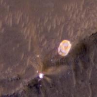
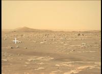
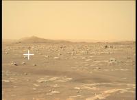


 A dust devil on sol 17--I wonder if there are more?