China to the Moon - Chang'e 1 and 2, Chinese unmanned lunar orbiters |

China to the Moon - Chang'e 1 and 2, Chinese unmanned lunar orbiters |
 Aug 24 2006, 05:03 PM Aug 24 2006, 05:03 PM
Post
#1
|
|
 Member  Group: Members Posts: 124 Joined: 23-March 06 Member No.: 723 |
Lunar Programme To Be Open To World
Although China is still in the "initial stage" in tapping the moon and outer space when compared with the United States, Russia and Europe, the nation is catching up, Luan said. http://www.spacedaily.com/dragonspace.html The first phase of the Chang'e Project was solely accomplished by China through its own technology, products and designs, said Luan, former director of the China National Space Administration (CNSA). However, lunar scientists from Europe, the United States and Russia have expressed their willingness to co-operate with China in its research of the moon and deep space exploration, he said. Chinese scientists are assembling, integrating and testing to ensure that the mission of the nation's first lunar explorer, Chang'e-1, goes smoothly, a top space official said yesterday. http://english.people.com.cn/200607/26/eng...726_286707.html "Fundamental development has been achieved in all five related systems ranging from the satellite, the rocket, tracking and control, ground applications and the launch centre since it was approved two years ago," said Sun Laiyan, head of the China National Space Administration. The lunar orbiter is scheduled to blast off next year from the Xichang Satellite Launch Centre in Southwest China's Sichuan Province, Sun said at the ongoing eighth International Lunar Exploration Working Group (ILEWG) Conference in Beijing. The spacecraft will be 2350 kilograms in weight. According to the plan, the program will go through four phases. 1. Send a satellite to orbit the Moon 2. Conduct exploration on the surface of the moon through the soft landing of a detector. 3. Collect Moon surface samples using a robot, which will then return to the Earth. 4. Manned missions. http://en.wikipedia.org/wiki/Chang'e_program According to the schedule, detailed program design of the first step will be completed by September 2004. Research and development of a prototype probe and relevant testing of the probe will be finished before the end of 2005. Design, manufacture, general assembly, test and ground experiments of the lunar probe satellite will be finished before December 2006. In 2007 the Chang'e 1 will blast off. |
 |
 
|
 |
|
Aug 17 2008, 05:27 PM
Post
#91
|
|
 Senior Member Group: Members Posts: 1441 Joined: 26-July 08 Member No.: 4270 |
I remember a while back that someone found that one of the Chang'e 1 images of the lunar surface was doctored up a little. I wonder how accurate this "700 hours" of data would be. But then again, I desperately want a nice lunar map for Celestia...
The information is being sent QUOTE ...to domestic authorized users and the European Space Agency I don't know which would be harder, getting the information from the Chinese, or the ESA. -------------------- -- Hungry4info (Sirius_Alpha)
|
|
|
|
|
Aug 17 2008, 09:05 PM
Post
#92
|
|
 Senior Member Group: Members Posts: 3648 Joined: 1-October 05 From: Croatia Member No.: 523 |
QUOTE (Hungry4info @ Aug 17 2008, 07:27 PM)  one of the Chang'e 1 images of the lunar surface was doctored up a little The seams between imaging strips were blended in to make the result more aesthetically pleasing. The pointing/position knowledge wasn't good enough to do this automatically at that point in time. You'd be surprised how much many of the other space images are "doctored" before release. -------------------- |
|
|
|
|
Aug 17 2008, 09:46 PM
Post
#93
|
|
 Senior Member Group: Members Posts: 1643 Joined: 5-March 05 From: Boulder, CO Member No.: 184 |
QUOTE (Hungry4info @ Aug 17 2008, 05:27 PM) I desperately want a nice lunar map for Celestia... This one might work for the time being, based on Clementine data... http://laps.noaa.gov/albers/sos/sos.html#MOON Steve |
|
|
|
|
Aug 17 2008, 11:57 PM
Post
#94
|
|
|
Senior Member Group: Members Posts: 1441 Joined: 26-July 08 Member No.: 4270 |
full inline quote removed
That's the one I use currently. I'm hoping once LRO is finished, we can get a better map. I mean not to devalue your work, you do a lot of good work with your maps and I do appreciate it. I'm one of those, though, that wants to be able to see gum on the sidewalk in my virtual textures for Celestia. My Earth texture is 32,000 x 16,000 px (if anyone knows where to find one that is larger, please say something). I deeply desire a lunar map of similar proportions with excellent resolution. I figure that a 32,000 x 16,000 px map for the moon should give a resolution of somewhere around 300 m per pixel. I guess the thing to do is head over to the USGS Map-a-planet and download a bunch of pictures and stitch them together later, lol. I'll go do that now. -------------------- -- Hungry4info (Sirius_Alpha)
|
|
|
|
|
Aug 18 2008, 02:25 AM
Post
#95
|
|
|
Senior Member Group: Members Posts: 1441 Joined: 26-July 08 Member No.: 4270 |
I found new toys at the USGS site. If anyone wants a 16,384 x 8,192 px map of the moon, you can get it here until Aug 20.
http://pdsmaps.wr.usgs.gov/order/I_Am_Aliv...moon00n000.html -------------------- -- Hungry4info (Sirius_Alpha)
|
|
|
|
|
Aug 23 2008, 03:42 PM
Post
#96
|
|
|
Senior Member Group: Members Posts: 1643 Joined: 5-March 05 From: Boulder, CO Member No.: 184 |
Thanks for your comments Hungry...
I usually stick to 8K maps as that is the biggest I can easily produce and/or display (e.g. with Celestia). Good to know about the larger moon one at the USGS, and the potential with the Chinese probe data. I think the Blue Marble Next Generation from NASA would be a good one to check for Earth. It supposedly goes up to 500m resolution, so if that's true it would be quite a lot of pixels. Steve |
|
|
|
|
Aug 23 2008, 08:01 PM
Post
#97
|
|
|
Member Group: Members Posts: 104 Joined: 1-June 08 Member No.: 4172 |
I happen to have a 20K x 10k map (same Clementine/USGS Map A Planet source) lying around from an attempt to create a moon overlay for Google Earth; I have uploaded it in case it will be of use to anyone (it's centered 180 degrees off from the USGS ones, and is too big (104 Mb) for me to edit).
http://www.transferbigfiles.com/Get.aspx?i...a0-5913890be569 It should be available until the 28th. |
|
|
|
|
Nov 12 2008, 12:01 PM
Post
#98
|
|
|
Solar System Cartographer Group: Members Posts: 10186 Joined: 5-April 05 From: Canada Member No.: 227 |
http://news.xinhuanet.com/english/2008-11/...nt_10347379.htm
Chang-e's big global photomosaic on dispay. Let's hope we get to see it online at some point. Phil -------------------- ... because the Solar System ain't gonna map itself.
Also to be found posting similar content on https://mastodon.social/@PhilStooke Maps for download (free PD: https://upload.wikimedia.org/wikipedia/comm...Cartography.pdf NOTE: everything created by me which I post on UMSF is considered to be in the public domain (NOT CC, public domain) |
|
|
|
|
Nov 25 2008, 10:29 PM
Post
#99
|
|
|
Solar System Cartographer Group: Members Posts: 10186 Joined: 5-April 05 From: Canada Member No.: 227 |
-------------------- ... because the Solar System ain't gonna map itself.
Also to be found posting similar content on https://mastodon.social/@PhilStooke Maps for download (free PD: https://upload.wikimedia.org/wikipedia/comm...Cartography.pdf NOTE: everything created by me which I post on UMSF is considered to be in the public domain (NOT CC, public domain) |
|
|
|
|
Nov 25 2008, 10:47 PM
Post
#100
|
|
|
Founder Group: Chairman Posts: 14433 Joined: 8-February 04 Member No.: 1 |
Forgive my ignorance - but if it ever gets 'out' of China - will this represent a better base map than, for example, the Clementine stuff on map-a-planet?
Doug |
|
|
|
|
Nov 25 2008, 10:56 PM
Post
#101
|
|
|
Solar System Cartographer Group: Members Posts: 10186 Joined: 5-April 05 From: Canada Member No.: 227 |
My impression is that it will be similar in lighting and resolution to Clementine. 100 m/pixel, fairly high sun at low latitudes. But that's not to say it will be identical. It is multispectral, and may sample different spectral bands than Clementine. Clementine has some poor areas where missed strips were filled in from higher altitude images, this might not. Also near the poles the lighting will be a bit different depending on the lunar seasons - Clementine only mapped for a couple of months so it saw limited seasonal variation. (for instance, the south rim of Shoemaker is visible here but not in Clementine). If we do get the full data set released, as China says we will - it will be complementary to Clementine.
Phil -------------------- ... because the Solar System ain't gonna map itself.
Also to be found posting similar content on https://mastodon.social/@PhilStooke Maps for download (free PD: https://upload.wikimedia.org/wikipedia/comm...Cartography.pdf NOTE: everything created by me which I post on UMSF is considered to be in the public domain (NOT CC, public domain) |
|
|
|
| Guest_Zvezdichko_* |
Nov 29 2008, 11:03 PM
Post
#102
|
|
|
Guests |
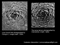
Lunar South Pole as imaged by Chang'e and Clementine.
Attached thumbnail(s)
|
|
|
|
|
|
|
Dec 10 2008, 02:29 PM
Post
#103
|
|
|
Solar System Cartographer Group: Members Posts: 10186 Joined: 5-April 05 From: Canada Member No.: 227 |
Reports now that Chang-e 1 has lowered its orbit to 100 km for a period of higher resolution imaging, to be followed by another drop in altitude to test systems for future landers - presumably navigation towards a final impact. So next year we'll probably see five lunar impacts - Kaguya's relay satellite, Kaguya itself, LCROSS's rocket stage and observation satellite, and Chang-e 1. Not necessarily in that order.
Phil -------------------- ... because the Solar System ain't gonna map itself.
Also to be found posting similar content on https://mastodon.social/@PhilStooke Maps for download (free PD: https://upload.wikimedia.org/wikipedia/comm...Cartography.pdf NOTE: everything created by me which I post on UMSF is considered to be in the public domain (NOT CC, public domain) |
|
|
|
|
Dec 10 2008, 06:56 PM
Post
#104
|
|
|
Solar System Cartographer Group: Members Posts: 10186 Joined: 5-April 05 From: Canada Member No.: 227 |
... and you might like to see what this update says about future missions, and data access:
http://www.lpi.usra.edu/features/chang_e/mapComplete/ Phil -------------------- ... because the Solar System ain't gonna map itself.
Also to be found posting similar content on https://mastodon.social/@PhilStooke Maps for download (free PD: https://upload.wikimedia.org/wikipedia/comm...Cartography.pdf NOTE: everything created by me which I post on UMSF is considered to be in the public domain (NOT CC, public domain) |
|
|
|
| Guest_Zvezdichko_* |
Jan 3 2009, 01:21 PM
Post
#105
|
|
Guests |
http://yolearnchinese.com/archives/chinese...ed#comment-8074
Do you notice something weird? EDIT: Everything is OK now. A credit line is given and a hyperlink to unmannedspaceflight.com was added. |
|
|
|
 |

|
Lo-Fi Version | Time is now: 6th June 2024 - 06:13 AM |
|
RULES AND GUIDELINES Please read the Forum Rules and Guidelines before posting. IMAGE COPYRIGHT |
OPINIONS AND MODERATION Opinions expressed on UnmannedSpaceflight.com are those of the individual posters and do not necessarily reflect the opinions of UnmannedSpaceflight.com or The Planetary Society. The all-volunteer UnmannedSpaceflight.com moderation team is wholly independent of The Planetary Society. The Planetary Society has no influence over decisions made by the UnmannedSpaceflight.com moderators. |
SUPPORT THE FORUM Unmannedspaceflight.com is funded by the Planetary Society. Please consider supporting our work and many other projects by donating to the Society or becoming a member. |
|