The West Valley Route |

The West Valley Route |
 Mar 18 2009, 12:00 PM Mar 18 2009, 12:00 PM
Post
#1
|
|
|
Senior Member  Group: Moderator Posts: 4279 Joined: 19-April 05 From: .br at .es Member No.: 253 |
Here're the latest navcam pictures taken during sol 1850: http://nasa.exploratorium.edu/mars/spirit/navcam/2009-03-18/
Spirit is no longer stuck, but I think the attempt to go on top of HP via the NE path is finished and we are going to the West Valley. A pancam mosaic of the western route is planned for tosol. |
 |
 
|
 |
|
Mar 25 2009, 07:28 PM
Post
#76
|
|
|
Member Group: Admin Posts: 976 Joined: 29-September 06 From: Pasadena, CA - USA Member No.: 1200 |
QUOTE (HughFromAlice @ Mar 25 2009, 11:20 AM)  I've often wondered how long it would take to erase the wheel tracks! Knowing the rate at which they are being erased in different soil types, wind regimes etc could give a lot of very interesting info on geological time frames. In fact, just from the tracks themselves there must be a lot of info (additional to the dragged wheel discoveries). Is anyone studying this - any papers on it - earlier comments in UMSF - or any one got any comments on this? We are getting OT here, so if the Admins want to remove this post please do so. After Opportunity left Duck Bay we stopped at a location where tracks from sol 950-952 and 1291 were visible. The 95x tracks were very degraded from the dust storm of July-August 2007. I believe NAVCAMs and PANCAMS were taken of those tracks and probably this was the best opportunity (no pun intended) to study the track appearance in time. Paolo -------------------- Disclaimer: all opinions, ideas and information included here are my own,and should not be intended to represent opinion or policy of my employer.
|
|
|
|
|
Mar 25 2009, 08:34 PM
Post
#77
|
|
 Senior Member Group: Members Posts: 4251 Joined: 17-January 05 Member No.: 152 |
There were great pictures and some discussion in the Leaving Victoria Crater thread, starting with this post.
Also, we saw Spirit's tracks start to get obscured after the big dust storm, check out the thread starting with this post. |
|
|
|
|
Mar 25 2009, 11:29 PM
Post
#78
|
||
 Senior Member Group: Admin Posts: 3108 Joined: 21-December 05 From: Canberra, Australia Member No.: 615 |
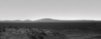
Back in the West Valley...
An enhanced view of Grissom Hill and beyond.
|
|
|
|
|
|
|
Mar 26 2009, 08:09 AM
Post
#79
|
|
 Special Cookie Group: Members Posts: 2168 Joined: 6-April 05 From: Sintra | Portugal Member No.: 228 |
Hmm...here wondering...how far is that?

-------------------- "Ride, boldly ride," The shade replied, "If you seek for Eldorado!"
Edgar Alan Poe |
|
|
|
|
Mar 26 2009, 08:35 AM
Post
#80
|
|
 Senior Member Group: Moderator Posts: 2262 Joined: 9-February 04 From: Melbourne - Oz Member No.: 16 |
About 7.5km from the landing site.
http://marsrovers.nasa.gov/gallery/press/s...sApollo_br2.jpg Add maybe 1km to that from our current position. http://marsrovers.nasa.gov/gallery/press/s...pApollo_br2.jpg A little far for a 5 wheeled rover I'd say. 
-------------------- |
|
|
|
|
Mar 26 2009, 08:59 AM
Post
#81
|
|
|
Senior Member Group: Moderator Posts: 4279 Joined: 19-April 05 From: .br at .es Member No.: 253 |
... producing 230 Wh/day. A bit difficult, yes.
Now, back to the current activities, tosol drive was about 12 meters SSW. Pictures should be in the web soon. |
|
|
|
|
Mar 26 2009, 03:03 PM
Post
#82
|
|
 Senior Member Group: Moderator Posts: 3431 Joined: 11-August 04 From: USA Member No.: 98 |
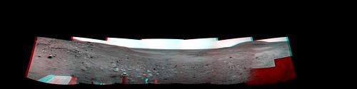 Navcam anaglyph mosaic facing east, sol 1858. 180x90 degree cylindrical projection. QuickTime VR version (2.9MB) Looks like the rover drivers have some challenging terrain ahead. |
|
|
|
|
Mar 26 2009, 03:06 PM
Post
#83
|
|
|
Senior Member Group: Moderator Posts: 4279 Joined: 19-April 05 From: .br at .es Member No.: 253 |
This navcam picture is pointing to the site Spirit was during the first science campaing.
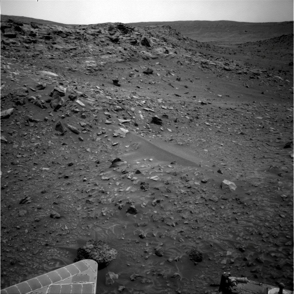 Compare it with James' mosaic here. |
|
|
|
|
Mar 26 2009, 03:26 PM
Post
#84
|
|
|
Senior Member Group: Moderator Posts: 2262 Joined: 9-February 04 From: Melbourne - Oz Member No.: 16 |
QUOTE (Tesheiner @ Mar 26 2009, 03:06 PM) Compare it with James' mosaic here. Might also be a good time to repost the full Gibson Pan:  Posted 26/02/2006 - 37 months ago. Back when Spirit was young a sprightly and able to climb HP here. And the colour anaglyph  -------------------- |
|
|
|
|
Mar 26 2009, 03:34 PM
Post
#85
|
|
|
Member Group: Members Posts: 530 Joined: 21-March 06 From: Canada Member No.: 721 |
Well, at least one rover is on the move. I really hate it when they let the scientists out of their cages.

|
|
|
|
|
Mar 26 2009, 04:17 PM
Post
#86
|
|
|
Senior Member Group: Moderator Posts: 4279 Joined: 19-April 05 From: .br at .es Member No.: 253 |
QUOTE (mhoward @ Mar 26 2009, 04:03 PM) Looks like the rover drivers have some challenging terrain ahead. <back-seat mode on> The West Valley has an E-W slope, perpendicular to the planned path, so I would suggest to keep Spirit as much as possible to the left (near HP) to avoid losing altitude. <back-seat mode off> |
|
|
|
|
Mar 26 2009, 06:17 PM
Post
#87
|
|
|
Member Group: Members Posts: 311 Joined: 31-August 05 From: Florida & Texas, USA Member No.: 482 |
I'd agree that hugging Home Plate's base seems like the best drive path through west valley. However, is Tiolkovsky a different composition from Home Plate, or is it part of the same formation that is just split by the valley? If it's different, maybe it's worth closer examination?
|
|
|
|
|
Mar 26 2009, 07:26 PM
Post
#88
|
|
|
Member Group: Admin Posts: 976 Joined: 29-September 06 From: Pasadena, CA - USA Member No.: 1200 |
QUOTE (Tesheiner @ Mar 26 2009, 08:17 AM) <back-seat mode on> The West Valley has an E-W slope, perpendicular to the planned path, so I would suggest to keep Spirit as much as possible to the left (near HP) to avoid losing altitude. <back-seat mode off> That's what we will try to do. The thing to balance is the soil type. Near HP base there are several locations where fine dust has accumulated and as we have seen this type of terrain can lead to trouble. Paolo -------------------- Disclaimer: all opinions, ideas and information included here are my own,and should not be intended to represent opinion or policy of my employer.
|
|
|
|
|
Mar 26 2009, 08:03 PM
Post
#89
|
|
|
Senior Member Group: Members Posts: 2922 Joined: 14-February 06 From: Very close to the Pyrénées Mountains (France) Member No.: 682 |
IIRC, one of the reason for not using the West Valley Route was because we didn't have enough visual informations as compared to crossing HP or using the East route. Not mentioning the laters were shorter, etc...
Once again, looking at Eduardo's map, I'd said that I guess we have very good coverage (even from to of HP) around Gibson then again around Tartarus; this leads to sol 1363 drive that will join sol 1350 way point. Either I missunderstood or this is not enough to call the route "known enough" for a Rover Driver standard. Anyway, even if we can use the pictures we have down to sol 1350 way point or so, this will cover half the distance to Von Braun. 
-------------------- |
|
|
|
|
Mar 26 2009, 08:18 PM
Post
#90
|
|
|
Senior Member Group: Members Posts: 2922 Joined: 14-February 06 From: Very close to the Pyrénées Mountains (France) Member No.: 682 |
By the way, here is a link from Ant103 new and very nice web site that shows a part of the route: http://www.astrosurf.com/merimages/Spirit/...l758-medres.jpg
-------------------- |
|
|
|
 |

|
Lo-Fi Version | Time is now: 5th June 2024 - 04:47 AM |
|
RULES AND GUIDELINES Please read the Forum Rules and Guidelines before posting. IMAGE COPYRIGHT |
OPINIONS AND MODERATION Opinions expressed on UnmannedSpaceflight.com are those of the individual posters and do not necessarily reflect the opinions of UnmannedSpaceflight.com or The Planetary Society. The all-volunteer UnmannedSpaceflight.com moderation team is wholly independent of The Planetary Society. The Planetary Society has no influence over decisions made by the UnmannedSpaceflight.com moderators. |
SUPPORT THE FORUM Unmannedspaceflight.com is funded by the Planetary Society. Please consider supporting our work and many other projects by donating to the Society or becoming a member. |
|