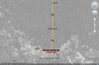
The western route, 5th leg after stop at Absecon / Reeds Bay |

The western route, 5th leg after stop at Absecon / Reeds Bay |
 Jul 11 2009, 05:57 PM Jul 11 2009, 05:57 PM
Post
#1
|
||
|
Senior Member  Group: Moderator Posts: 4279 Joined: 19-April 05 From: .br at .es Member No.: 253 |
Time for a new thread.
After moving southwards for ages, the "detour" by the western path has started with a 60+ meters drive on sol 1942.
There are no images yet --they should be available on the next update-- so this image was calculated solely based on the rover's mobility info. I'll update the route map later. |
|
 |
 
|
|
 |
|
Jul 22 2009, 01:48 PM
Post
#46
|
|
|
Senior Member Group: Moderator Posts: 4279 Joined: 19-April 05 From: .br at .es Member No.: 253 |
It was named "Block Island".
01946::p2532::23::13::13::0::0::2::28::pancam_Block_Island_L234567Rall |
|
|
|
|
Jul 22 2009, 03:03 PM
Post
#47
|
|
|
Member Group: Members Posts: 913 Joined: 4-September 06 From: Boston Member No.: 1102 |
Tesheiner, would it be possible put a label for Block Island on your map (even if too small to actually see on the map image)? I'm confused as to which crater it is sitting in front of. It isn't Alvin?
-------------------- |
|
|
|
|
Jul 22 2009, 03:17 PM
Post
#48
|
|
 Senior Member Group: Members Posts: 4252 Joined: 17-January 05 Member No.: 152 |
"Block Island" is actually a ways south of the sol 1942 location:
http://marsrovers.jpl.nasa.gov/gallery/all...00P1962R0M1.JPG (And it's roughly 25 cm tall.) So that would mean some significant backtracking if that were a target. I'm baffled by this reversal. Edit: perhaps Oppy's gotten tired of seeing her destination in the rearview mirror: http://marsrovers.jpl.nasa.gov/gallery/all...NMP1760R0M1.JPG and she's revolted!   
|
|
|
|
|
Jul 22 2009, 03:45 PM
Post
#49
|
|
|
Member Group: Members Posts: 530 Joined: 21-March 06 From: Canada Member No.: 721 |
Or this is a repeat of that programming glitch that made her go one way when she meant to go the other, although one would assume they got that issue sorted out.
I'm hopeful this is a sign that the Endeavour clays have become such a high-priority target that they have decided on the shorter, presumably quicker but riskier route to increase their chances of getting there before the overriding enemy that is time ultimately results in a critical system failure that will stop Oppy dead in her tracks. In other words, move from the philosophy that "south is the way to go, and IF we get to Endeavour, that's a bonus" to "we must reach Endeavour or die trying". |
|
|
|
|
Jul 22 2009, 05:02 PM
Post
#50
|
|
|
Senior Member Group: Moderator Posts: 4279 Joined: 19-April 05 From: .br at .es Member No.: 253 |
No way that it would be another instance of the "glitch". The evidence is the "post-drive" mosaics because they are pointing WSW, same as the driving direction.
I would expect some news on the next status report in a few days, unless someone in the know posts some tidbits here. |
|
|
|
|
Jul 22 2009, 05:04 PM
Post
#51
|
|
|
Member Group: Members Posts: 362 Joined: 13-April 06 From: Malta Member No.: 741 |
So now we're sailing in the north atlantic along the northeastern US COAST...watch out for JAWS next!

|
|
|
|
|
Jul 22 2009, 06:21 PM
Post
#52
|
|
|
Member Group: Senior Member Posts: 136 Joined: 8-August 06 Member No.: 1022 |
QUOTE (Floyd @ Jul 22 2009, 07:03 AM)  Tesheiner, would it be possible put a label for Block Island on your map (even if too small to actually see on the map image)? I'm confused as to which crater it is sitting in front of. It isn't Alvin? Block Island is visible in the HiRISE image, meaning it's fairly large, which is one reason we're going back. Other reason(s) I'll leave up to the reader! (more fun that way!) -Tim. |
|
|
|
|
Jul 22 2009, 07:04 PM
Post
#53
|
|
|
Senior Member Group: Members Posts: 4252 Joined: 17-January 05 Member No.: 152 |
I estimate Block Island is roughly 25 cm tall by 50 cm wide (orthogonal to our line of sight). That's assuming it's sitting at the same elevation as Oppy's wheels were, and also that the horizon was level with pancam. (Probably not horrible approximations on Meridiani!)
Could someone who has the full resolution HiRISE post a full res crop showing the area of Block Island? I estimate it's about 50 metres S or SSW from the sol 1942 location. |
|
|
|
| Guest_Sunspot_* |
Jul 22 2009, 07:06 PM
Post
#54
|
|
Guests |
QUOTE (alan @ Jul 22 2009, 12:38 PM) Going back for closer look at this perhaps? [attachment=18574:1P300935...2532l456.jpg] Looks like a Land Rover stuck in the Sahara..... kind of 
|
|
|
|
|
Jul 22 2009, 07:44 PM
Post
#55
|
|
 Member Group: Members Posts: 813 Joined: 8-February 04 From: Arabia Terra Member No.: 12 |
Great news!
 This will take me more time to tweak my google earth map extension (it's proving trickier than i thought). This will take me more time to tweak my google earth map extension (it's proving trickier than i thought).
|
|
|
|
|
Jul 22 2009, 08:01 PM
Post
#56
|
||
 Member Group: Members Posts: 221 Joined: 25-March 05 Member No.: 217 |
Hi FredK
Here's a crop of the region I think you want. I may be wrong, can't see the rock. I can crop a different area if you wish. Roy F
Attached thumbnail(s)
|
|
|
|
|
|
|
Jul 22 2009, 08:25 PM
Post
#57
|
|
|
Member Group: Senior Member Posts: 136 Joined: 8-August 06 Member No.: 1022 |
Roy:
It's in there! -Tim. |
|
|
|
|
Jul 22 2009, 09:22 PM
Post
#58
|
|
 Member Group: Members Posts: 237 Joined: 22-December 07 From: Alice Springs, N.T. Australia Member No.: 3989 |
Would someone who can see where it is please circle it and repost the pic! Can't see it.

|
|
|
|
|
Jul 22 2009, 09:35 PM
Post
#59
|
||
|
Member Group: Senior Member Posts: 136 Joined: 8-August 06 Member No.: 1022 |
QUOTE (HughFromAlice @ Jul 22 2009, 01:22 PM) Would someone who can see where it is please circle it and repost the pic! Can't see it.
|
|
|
|
|
|
|
Jul 22 2009, 09:46 PM
Post
#60
|
|
|
Founder Group: Chairman Posts: 14433 Joined: 8-February 04 Member No.: 1 |
I can well understand why we're going to have a look. Not only does it look different to all the surrounding rock - it's also, I'd guess, the single largest rock not in a crater that Opportunity has ever seen.
|
|
|
|
 |

|
Lo-Fi Version | Time is now: 10th June 2024 - 12:12 PM |
|
RULES AND GUIDELINES Please read the Forum Rules and Guidelines before posting. IMAGE COPYRIGHT |
OPINIONS AND MODERATION Opinions expressed on UnmannedSpaceflight.com are those of the individual posters and do not necessarily reflect the opinions of UnmannedSpaceflight.com or The Planetary Society. The all-volunteer UnmannedSpaceflight.com moderation team is wholly independent of The Planetary Society. The Planetary Society has no influence over decisions made by the UnmannedSpaceflight.com moderators. |
SUPPORT THE FORUM Unmannedspaceflight.com is funded by the Planetary Society. Please consider supporting our work and many other projects by donating to the Society or becoming a member. |
|