Cape York, Landfall! |

Cape York, Landfall! |
 Aug 10 2011, 06:30 AM Aug 10 2011, 06:30 AM
Post
#1
|
||
|
Senior Member  Group: Moderator Posts: 4279 Joined: 19-April 05 From: .br at .es Member No.: 253 |
Its finally time for a new thread. THE thread, I would say.
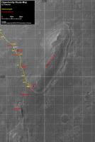
It is now sol 2681 and after virtually one thousand sols, beginning on 1683 when Opportunity left Victoria for good, and also after more than 21km driving on these flat fields, this little rover and obviously the brave missions people behind, made landfall on Cape York. A bunch of pictures and thumbnails are already on the ground (should be public in an hour or so) and the very limited data we can gather for the time being are just enough to guess a drive of around 60m. Ive prepared a new picture to use as a map to follow this part of the mission and which I will update, as usual, on the route map thread once more data are available. Heres a copy of it.
Use this thread for comments, discussions, mosaics, images result of activities at / after sol 2681 and keep using the Post Conjunction: Santa Maria to Cape York, The Journey to 'Spirit Point' thread for posts related with stuff from before sol 2681. |
|
 |
 
|
|
 |
|
Aug 11 2011, 02:23 PM
Post
#91
|
|
 Senior Member Group: Members Posts: 2173 Joined: 28-December 04 From: Florida, USA Member No.: 132 |
This armchair geologist is at a total loss. The only preconception I had of Cape York that may hold true is that the large blocks of Odyssey ejecta may yet turn out to be basaltic boulders. That and a scattering of blueberries indicating that concretion forming sulfate layers once covered Cape York. But have the sulfate layers been entirely eroded away? I can't wait to see what the MI and APXS will reveal!
The only thing I know for sure: When Opportunity moves to the edge of Odyssey, she will be sitting on the rim of a crater... on the rim of a crater! |
|
|
|
|
Aug 11 2011, 02:34 PM
Post
#92
|
|
 The Poet Dude Group: Moderator Posts: 5551 Joined: 15-March 04 From: Kendal, Cumbria, UK Member No.: 60 |
QUOTE (centsworth_II @ Aug 11 2011, 03:23 PM)  When Opportunity moves to the edge of Odyssey, she will be sitting on the rim of a crater... on the rim of a crater! ...and when HiRISE takes its first pic of Oppy after landfall, it should look something like this... http://twitpic.com/64ehoa/full -------------------- |
|
|
|
|
Aug 11 2011, 02:54 PM
Post
#93
|
|
|
Senior Member Group: Members Posts: 2173 Joined: 28-December 04 From: Florida, USA Member No.: 132 |
QUOTE (Stu @ Aug 11 2011, 10:34 AM) ...should look something like this... How tiny she is!Looking at the size scale of Oppy to Odyssey to CY to Endeavour, is like comparing a viral particle to a bacterium to a skin cell to a finger tip! |
|
|
|
|
Aug 11 2011, 03:00 PM
Post
#94
|
|
|
The Poet Dude Group: Moderator Posts: 5551 Joined: 15-March 04 From: Kendal, Cumbria, UK Member No.: 60 |
That scale size demonstration is **brilliant**! Love things like that.

-------------------- |
|
|
|
|
Aug 11 2011, 03:38 PM
Post
#95
|
|
 Member Group: Members Posts: 267 Joined: 5-February 06 Member No.: 675 |
Mini TES hasn't been used for a long time. The last I heard it was severely crippled by a dusty mirror, but theoretically functional.
Any chance it could be used to follow up on the CRISM phyllosilicate signatures? I imagine picking the signal out of the noise of the dust would be a real challenge. SteveM |
|
|
|
|
Aug 11 2011, 04:40 PM
Post
#96
|
|
|
Senior Member Group: Members Posts: 2090 Joined: 13-February 10 From: Ontario Member No.: 5221 |
It's still covered, according to Emily's latest post.
It's doubtful they can clean it after so long. |
|
|
|
|
Aug 11 2011, 04:55 PM
Post
#97
|
|
|
Newbie Group: Members Posts: 7 Joined: 19-July 05 Member No.: 444 |
So, what instruments can they still use to determine the mineralogy of things now that we are here? Other than a close up picture. Are phyllosilicate's iron bearing so the Mossbauer can be used?
|
|
|
|
|
Aug 11 2011, 04:56 PM
Post
#98
|
|
|
Member Group: Members Posts: 267 Joined: 5-February 06 Member No.: 675 |
If Emily says "Mini TES ... is hopelessly contaminated" I'll take the situation as truly hopeless.

|
|
|
|
|
Aug 11 2011, 05:55 PM
Post
#99
|
|
|
Senior Member Group: Members Posts: 2922 Joined: 14-February 06 From: Very close to the Pyrénées Mountains (France) Member No.: 682 |
QUOTE (rschare @ Aug 11 2011, 05:55 PM) So, what instruments can they still use to determine the mineralogy of things now that we are here? Other than a close up picture. Are phyllosilicate's iron bearing so the Mossbauer can be used? Have a look at the end of Emily's blog here: http://www.planetary.org/blog/article/00003137/ -------------------- |
|
|
|
|
Aug 11 2011, 09:32 PM
Post
#100
|
|
 Member Group: Members Posts: 557 Joined: 1-May 06 From: Scotland (Ecosse, Escocia) Member No.: 759 |
QUOTE (mhoward @ Aug 11 2011, 03:28 AM) Full right Navcam panorama for 2681-2682 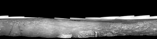 Thanks for this wonderful pano, mhoward. Looking around and comparing it with Tesh's map, I am especially struck by the appearance of Sutherland Point beyond the dark bay to the Right of the rover mast. You can see some subtle undulating topography in it which is so slight, compared with the prominent ridge appearance in the HiRISE map. Another example of how we were fooled by the orbital photos into thinking these crater rim features were much, much taller than they really are. How they can appear so prominent from above, yet be so negligible from gound level, is still pretty mystifying... |
|
|
|
| Guest_Bobby_* |
Aug 12 2011, 03:46 AM
Post
#101
|
|
Guests |
WOW is the best word to Describe what I'm seeing and good job everyone.
I have a few Questions? 1. I would like to know where the official Rim of Endevour Starts and when did we cross that point? Are there any overhead shots showing the rim as a circular pattern? There probably is an image somewhere in UMSF and I missed it. 2. With the current degrading of certain science tools on Oppy. Does it take roughly 2 weeks to examine any rock now? Thanks Bobby |
|
|
|
|
Aug 12 2011, 04:53 AM
Post
#102
|
|
|
Junior Member Group: Members Posts: 52 Joined: 1-March 11 From: Houston, USA Member No.: 5860 |
QUOTE (Bobby @ Aug 11 2011, 09:46 PM) 1. (snip) Are there any overhead shots showing the rim as a circular pattern? NASA posts a good context image here: http://marsrovers.jpl.nasa.gov/newsroom/pr.../20110608a.html QUOTE (Bobby @ Aug 11 2011, 09:46 PM) 2. With the current degrading of certain science tools on Oppy. Does it take roughly 2 weeks to examine any rock now? The curium-244 used in the APXS has a half-life of 18.1 years, so integration times for it should not yet have doubled, everything else being equal. The Mossbauer, on the other hand, uses cobalt-57, which has a half life of 271.8 days. Since the date of launch eight years ago, that's 10.75 half-lives, reducing the source intensity by more than 1,722 times if my arithmetic is right, which I hope it's not. A measurement that took six hours might now take more than a terrestrial year, so they may be running it just long enough to get the bare minimum of a result above the background. |
|
|
|
|
Aug 12 2011, 06:04 AM
Post
#103
|
|
|
Senior Member Group: Moderator Posts: 4279 Joined: 19-April 05 From: .br at .es Member No.: 253 |
QUOTE (john_s @ Aug 12 2011, 02:03 AM) Is it possible this fissure formed when Opportunity ran over the adjacent piece of rock and displaced it? We've seen similar things before. Also, as Gibraltar was (I think) a pre-Cape York target, shouldn't it be in the "Post Conjunction..." thread? I understand why that thread was closed to encourage people to move to the new thread, but now that goal has been accomplished, shouldn't it be re-opened for posting of continued discussion of data from the long trek? John Completely right, John. Moved some posts and re-opened the thread. Cape York related posts, here. Gibraltar or earlier things, on the Post Conjunction thread, please. |
|
|
|
|
Aug 12 2011, 06:11 AM
Post
#104
|
|
|
Senior Member Group: Moderator Posts: 4279 Joined: 19-April 05 From: .br at .es Member No.: 253 |
Today's drive moved the rover about 15m towards the SE to a point somewhere on the S or SW corner of Odyssey. I will update the map once the pictures are available.
|
|
|
|
|
Aug 12 2011, 08:32 AM
Post
#105
|
||
 Member Group: Members Posts: 404 Joined: 5-January 10 Member No.: 5161 |
A little more of the crater's floor in view tonight, from the navcam.
|
|
|
|
|
|
 |

|
Lo-Fi Version | Time is now: 6th June 2024 - 04:57 AM |
|
RULES AND GUIDELINES Please read the Forum Rules and Guidelines before posting. IMAGE COPYRIGHT |
OPINIONS AND MODERATION Opinions expressed on UnmannedSpaceflight.com are those of the individual posters and do not necessarily reflect the opinions of UnmannedSpaceflight.com or The Planetary Society. The all-volunteer UnmannedSpaceflight.com moderation team is wholly independent of The Planetary Society. The Planetary Society has no influence over decisions made by the UnmannedSpaceflight.com moderators. |
SUPPORT THE FORUM Unmannedspaceflight.com is funded by the Planetary Society. Please consider supporting our work and many other projects by donating to the Society or becoming a member. |
|