Image Processing Software, Advice for image processing newbies |

Image Processing Software, Advice for image processing newbies |
 Sep 5 2007, 11:04 PM Sep 5 2007, 11:04 PM
Post
#1
|
|
 Senior Member  Group: Moderator Posts: 2785 Joined: 10-November 06 From: Pasadena, CA Member No.: 1345 |
What kind of image processing software would be good for a newbie interested in starting to manipulate basic images (JPEG, TIFF, PPG)?
Is there a big difference between Photoshop CS3 and Photoshop CS3 Extended? What do y'all recommend? (And how can I get this cheap? Man, this stuff looks expensive!) Any advice would be helpful, but I am so NOT an IT guy: I still move my lips when I try to read software manuals. (I usually just click the default option on installation windows and jsut hope everything works OK.) -Mike -------------------- Some higher resolution images available at my photostream: http://www.flickr.com/photos/31678681@N07/
|
 |
 
|
 |
|
Mar 29 2011, 05:08 AM
Post
#16
|
|
|
Member Group: Members Posts: 890 Joined: 18-November 08 Member No.: 4489 |
QUOTE What I'm really trying to figure out is if and where map-projected lat/long information is maintained. Thanks! ? in the isis cub file it is in the header and from spiceinit the time is given in the header and the location is imported from the spice kernel with the time and location the lat/long for every pixel can be calculated now some cub files like a map projected file like this example CODE GROUP = ISIS_INGESTION PDS2ISIS_VERSION = "2003-05-01" PDS2ISIS_TRANSLATION_TABLE = "/usgs/isisd/galdata/ssi_pds2isis_translation.def.1" END_GROUP = ISIS_INGESTION GROUP = ISIS_MOSAIC SPACECRAFT_NAME = (GALILEO_1,GALILEO_1,GALILEO_1,GALILEO_1) INSTRUMENT_ID = ("SSI","SSI","SSI","SSI") PRODUCT_ID = ("C9I0005","G2I0073","E6I0060","21I0170") IMAGE_NUMBER = ("0401740700","0359986578","0383758500","0506406839") END_GROUP = ISIS_MOSAIC GROUP = IMAGE_MAP_PROJECTION A_AXIS_RADIUS = 1821.46 B_AXIS_RADIUS = 1821.46 C_AXIS_RADIUS = 1821.46 POSITIVE_LONGITUDE_DIRECTION = "WEST" KEYWORD_LATITUDE_TYPE = "PLANETOCENTRIC" LONGITUDE_SYSTEM = 180 MINIMUM_LATITUDE = -90.0 MAXIMUM_LATITUDE = 90.0 WESTERNMOST_LONGITUDE = 180.0 EASTERNMOST_LONGITUDE = -180.0 MAP_RESOLUTION = 31.7904741933759 MAP_SCALE = 1.0 MAP_PROJECTION_TYPE = "SIMPLE_CYLINDRICAL" CENTER_LONGITUDE = 0.0 PROJECTION_LATITUDE_TYPE = "PLANETOGRAPHIC" LINE_PROJECTION_OFFSET = -2861.5 SAMPLE_PROJECTION_OFFSET = -5722.5 END_GROUP = IMAGE_MAP_PROJECTION END_OBJECT = QUBE END is set in the "IMAGE_MAP_PROJECTION" group or for this cub of dione "N1507741140_2.cub"( after spiceinit and NOT map projected ) it is in the "Group = Instrument "( the time) &"Group = Kernels " part of the header & in the body rotation CODE Group = Instrument SpacecraftName = Cassini-Huygens InstrumentId = ISSNA TargetName = Dione StartTime = 2005-284T16:30:24.493 StopTime = 2005-284T16:30:24.553 ExposureDuration = 60.0 <Milliseconds> AntibloomingStateFlag = On ------------------------------------and in the kernel ------------------------------------------------ Group = Kernels NaifFrameCode = -82360 LeapSecond = $base/kernels/lsk/naif0009.tls TargetAttitudeShape = ($base/kernels/pck/pck00009.tpc, $cassini/kernels/pck/cpck15Nov2005.tpc) TargetPosition = (Table, $base/kernels/spk/de405.bsp) InstrumentPointing = (Table, $cassini/kernels/ck/05282_05287ra.bc, $cassini/kernels/fk/cas_v40.tf) Instrument = Null SpacecraftClock = $cassini/kernels/sclk/cas00139.tsc InstrumentPosition = (Table, $cassini/kernels/spk/051114R_SCPSE_05275_05293.bsp) InstrumentAddendum = $cassini/kernels/iak/IssNAAddendum004.ti ShapeModel = Null InstrumentPositionQuality = Reconstructed InstrumentPointingQuality = Reconstructed CameraVersion = 1 End_Group End_Object ---------------- and the body rotation------------------------- Object = Table Name = BodyRotation StartByte = 4284569 Bytes = 40 Records = 1 ByteOrder = Lsb Description = "Created by spiceinit" Kernels = ($base/kernels/spk/de405.bsp, $base/kernels/pck/pck00009.tpc, $cassini/kernels/pck/cpck15Nov2005.tpc) SolarLongitude = 339.77037710307 so if it is not map projected then it is calculated on the fly qview does that when you view an image |
|
|
|
|
Mar 29 2011, 02:20 PM
Post
#17
|
|
|
Member Group: Members Posts: 293 Joined: 29-August 06 From: Columbia, MD Member No.: 1083 |
Thanks John! That's what I was unsure of. If this data was part of the .cub once the file was imported to IDL or if the .cub file just had pixel value data.
|
|
|
|
|
Dec 23 2011, 04:38 AM
Post
#18
|
||
|
Member Group: Members Posts: 808 Joined: 10-October 06 From: Maynard Mass USA Member No.: 1241 |
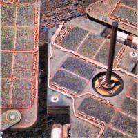
I was playing around with one of Oppy's deck pictures... I cant wait to see a good mosaic..
I just don't have a mosaic tool that would do these images justice... I could do this with the right tool! **** what's your favorite mosaic tool for MER images ? ****
In this test image, I tried to bring out the terrain below the solar wings and just ended up amplifying the JPEG artifacts on the solar cells (darn down sampled image!) I was going to grab the below wing terrain and paste it onto a regular L456 ... But I really should try a mosaic... -------------------- CLA CLL
|
|
|
|
|
|
|
Dec 24 2011, 02:46 PM
Post
#19
|
|
|
Member Group: Members Posts: 890 Joined: 18-November 08 Member No.: 4489 |
ISIS3 or for a normal mosaic Nip2
http://www.vips.ecs.soton.ac.uk/index.php?title=VIPS uses tie points http://www.vips.ecs.soton.ac.uk/supported/...ipguidese2.html |
|
|
|
|
Jan 3 2012, 01:44 AM
Post
#20
|
|
|
Newbie Group: Members Posts: 8 Joined: 23-January 10 Member No.: 5185 |
Quote removed - Mod
You could also use Hugin for a normal mosaic. http://hugin.sourceforge.net/ In the past (3 years ago), I had bad experiences with the software. Now-a-days it's actually pretty awesome and can stitch things together automatically. You can also swap out the automatic tie point software with whatever you like. |
|
|
|
 |

|
Lo-Fi Version | Time is now: 10th June 2024 - 09:42 AM |
|
RULES AND GUIDELINES Please read the Forum Rules and Guidelines before posting. IMAGE COPYRIGHT |
OPINIONS AND MODERATION Opinions expressed on UnmannedSpaceflight.com are those of the individual posters and do not necessarily reflect the opinions of UnmannedSpaceflight.com or The Planetary Society. The all-volunteer UnmannedSpaceflight.com moderation team is wholly independent of The Planetary Society. The Planetary Society has no influence over decisions made by the UnmannedSpaceflight.com moderators. |
SUPPORT THE FORUM Unmannedspaceflight.com is funded by the Planetary Society. Please consider supporting our work and many other projects by donating to the Society or becoming a member. |
|