Exploring Mt Sharp - The Dunes - Part 1: Bagnold Dunes, Site 51-53, Sol 1172-1273, November 24, 2015-March 6, 2016 |

Exploring Mt Sharp - The Dunes - Part 1: Bagnold Dunes, Site 51-53, Sol 1172-1273, November 24, 2015-March 6, 2016 |
 Nov 23 2015, 12:41 PM Nov 23 2015, 12:41 PM
Post
#1
|
||
 Senior Member  Group: Members Posts: 2429 Joined: 30-January 13 From: Penang, Malaysia. Member No.: 6853 |
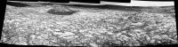
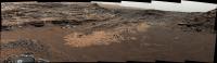
Midnight Planets reporting that Curiosity moved approximately 46.2m SSE (161º) on Sol 1172. LINK Quick and Dirty L-NavCam using the 5 available frames (MS ICE), reduced ~10% to get within the UL limit
|
|
 |
 
|
|
 |
|
Dec 16 2015, 06:20 PM
Post
#76
|
|
|
Junior Member Group: Members Posts: 58 Joined: 9-April 15 Member No.: 7433 |
http://mars.jpl.nasa.gov/msl/multimedia/ra...72M_&s=1194
Looks like they are getting some deck images to look at particles trails, plus from looks of other NavCam pics looks like we are skirting edge of dunes...amazing the dark albedo in contrast to the bright veins all over. Its interesting how these dunes are in such close proximity to other dunes with significantly different albedo...where is the source material? Maybe we will find it on the other side? I had imagined these dunes would not be as dark and "colorful" on the ground as the appeared from HiRise and MOC, but they are, maybe even more so :-) - I just hope the wheels stay together for a long time...some of the damaged areas are looking bad :-( |
|
|
|
|
Dec 16 2015, 07:10 PM
Post
#77
|
|
 Senior Member Group: Members Posts: 4247 Joined: 17-January 05 Member No.: 152 |
QUOTE (Arizona Dave @ Dec 16 2015, 07:20 PM)  other dunes with significantly different albedo Which other dunes do you mean? Direction of solar illumination and phase angle has a big effect on the brightness of these dunes. |
|
|
|
|
Dec 16 2015, 08:41 PM
Post
#78
|
|
 Member Group: Members Posts: 810 Joined: 3-June 04 From: Brittany, France Member No.: 79 |
My take on this awesome view of Namib dune:
ADMIN NOTE: Broken image link - click here to see image. As Sean, I added a picture of Mt Sharp from sol 1169 and extended the sky. Does someone know the height of this dune ? -------------------- |
|
|
|
|
Dec 16 2015, 10:31 PM
Post
#79
|
|||
|
Member Group: Members Posts: 866 Joined: 15-March 05 From: Santa Cruz, CA Member No.: 196 |
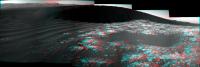
Thanks for the nice stitches of what to me at least now has sol1194 as having one of the most picturesque postcard-worthy snapshots of the mission. here's an anaglyph from a mediocre ICE stitch and a crosseye of the best part. I still hope there are full sizes of these sol1192 thumbs to send back
|
||
|
|
|
||
|
Dec 17 2015, 03:02 AM
Post
#80
|
|
|
Member Group: Members Posts: 923 Joined: 10-November 15 Member No.: 7837 |
QUOTE (neo56 @ Dec 16 2015, 08:41 PM) My take on this awesome view of Namib dune: ADMIN NOTE: Broken image link - click here to see image. As Sean, I added a picture of Mt Sharp from sol 1169 and extended the sky. Does someone know the height of this dune ? Lovely work there Thomas... great minds think alike!  I was too eager to complete mine before the left side of the dune appeared! I was too eager to complete mine before the left side of the dune appeared!
-------------------- |
|
|
|
|
Dec 17 2015, 04:30 AM
Post
#81
|
||
|
Senior Member Group: Members Posts: 2429 Joined: 30-January 13 From: Penang, Malaysia. Member No.: 6853 |
Curiosity Rover Mission Update by Lauren Edgar - Sols 1196-1197: Aeolian Paradise LINK
QUOTE On Sol 1194 Curiosity drove 47 m around the lee side of Namib Dune. The latest Navcam images reveal many beautiful aeolian features on the slipface and interdune deposits.
In todays 2-sol plan, well continue driving around Namib Dune. On the first sol well use ChemCam to assess the composition and grain size of a ripple. Then well use Mastcam to image the brink of the dune and its slipface to characterize the dune morphology. Well also use Mastcam to document an outcrop with an unusual purple hue. Afterwards, Curiosity will drive even closer to the dune slipface, and well take post-drive imaging to prepare for targeting over the weekend. On the second sol, well acquire a 360-degree Mastcam mosaic for geologic context. Well also use ChemCam to monitor the composition of the atmosphere, and Mastcam to assess atmospheric opacity. Throughout the plan Curiosity will acquire a lot of REMS observations to monitor the wind as we move through this dune field. As the GSTL today, it was a real challenge to get all of these observations into the plan while staying within our data volume constraints. Its hard to curb your imaging appetite when the views are so spectacular! |
|
|
|
|
|
|
Dec 17 2015, 08:01 AM
Post
#82
|
||
|
Senior Member Group: Members Posts: 2429 Joined: 30-January 13 From: Penang, Malaysia. Member No.: 6853 |
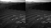
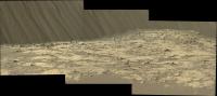
Sol 1194: 3 of the 5 drive direction L-Mastcam frames that capture some of the slip slope details. Raw colours without processing post assembly in MS ICE
The planned 360 Mastcam from in front of this active dune should be a memorable image 
|
|
|
|
|
|
|
Dec 17 2015, 08:27 AM
Post
#83
|
|
|
Senior Member Group: Members Posts: 2087 Joined: 13-February 10 From: Ontario Member No.: 5221 |
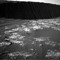
Wow, what an angle! Earth dunes can never get that steep, can they? A rare reminder of the lower gravity on the red planet...
|
|
|
|
|
Dec 17 2015, 08:58 AM
Post
#84
|
||
|
Senior Member Group: Members Posts: 2429 Joined: 30-January 13 From: Penang, Malaysia. Member No.: 6853 |
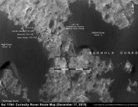
QUOTE (Explorer1 @ Dec 17 2015, 04:27 PM) Wow, what an angle! Earth dunes can never get that steep, can they? A rare reminder of the lower gravity on the red planet... Has anyone here attempted to estimate the angle of these slip slopes? Be interesting to compare the difference between the two planets:) Edit With Phil and Fernando both busy, I decided to have a very rough stab at the location at the end of the 1194 drive, I've added it onto Phil's 1192 map and posted it here to keep the signal to noise ratio down on the official map thread... Comments and criticism welcome  Check out the size of the slip-slope using the scale... It looks like ~10 m? So, if we know the angle we could estimate the actual height
|
|
|
|
|
|
|
Dec 17 2015, 01:25 PM
Post
#85
|
||
 Member Group: Members Posts: 913 Joined: 15-June 09 From: Lisbon, Portugal Member No.: 4824 |
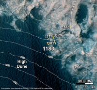
Here is a crop from MSL Traverse Map for Sol 1183. The ground seems to be sloping up, as the contour lines show a difference of at least 6m. Whether or not those are applicable to the High Dune itself I do not know. I have not seen similar data covering the Namib dune.
Fernando
|
|
|
|
|
|
|
Dec 17 2015, 03:03 PM
Post
#86
|
|
|
Member Group: Members Posts: 128 Joined: 10-December 06 From: Atlanta Member No.: 1472 |
QUOTE (Explorer1 @ Dec 17 2015, 03:27 AM) Wow, what an angle! Earth dunes can never get that steep, can they? A rare reminder of the lower gravity on the red planet... To the first approximation, the angle of repose is independent of the force of gravity (it cancels out). Now, this is not exactly true, as shown in this paper: http://onlinelibrary.wiley.com/doi/10.1029...003865/abstract . The actually measured the angle of repose of different materials in a "vomit comet" and saw some secondary effects. |
|
|
|
|
Dec 17 2015, 04:23 PM
Post
#87
|
|
|
Solar System Cartographer Group: Members Posts: 10173 Joined: 5-April 05 From: Canada Member No.: 227 |
For a really steep slope, check this out:
http://www.ourbc.com/travel_bc/bc_cities/s...oat__01_640.jpg You can't tell how steep a slope is by looking straight on to it (perpendicular to the dune foot). So a sideways view will be needed to estimate the real slope. Phil -------------------- ... because the Solar System ain't gonna map itself.
Also to be found posting similar content on https://mastodon.social/@PhilStooke Maps for download (free PD: https://upload.wikimedia.org/wikipedia/comm...Cartography.pdf NOTE: everything created by me which I post on UMSF is considered to be in the public domain (NOT CC, public domain) |
|
|
|
|
Dec 17 2015, 09:11 PM
Post
#88
|
||
|
Senior Member Group: Members Posts: 2836 Joined: 22-April 05 From: Ridderkerk, Netherlands Member No.: 353 |
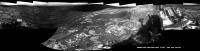
The Navcam L view on Sol 1194.
Jan van Driel
|
|
|
|
|
|
|
Dec 18 2015, 01:17 AM
Post
#89
|
||
|
Senior Member Group: Members Posts: 2429 Joined: 30-January 13 From: Penang, Malaysia. Member No.: 6853 |
JPL Press Release: Rocks Rich in Silica Present Puzzles for Mars Rover Team LINK
Edit: Video of the Associated Press Conference at the American Geophysical Union (AGU): 'Latest findings from NASAs Curiosity Mars rover mission One year at Mount Sharp' YouTube Link Duration: 18 minutes followed by 22 minutes of good questions from the press. Members of the science team for NASAs Curiosity Mars rover describe recent findings from investigations on the lower slope of Mount Sharp (Aeolis Mons). Some rocks there are highly enriched in silica, in contrast to the rock compositions seen on the surrounding plains. Other sites on Mars, such as ground investigated by NASAs Mars Exploration Rover Spirit, are also rich in silica. Researchers are looking at similarities and differences among silica-rich sites for understanding changes in ancient wet environments. Participants: Ashwin Vasavada, Project Scientist for Curiosity, NASA Jet Propulsion Laboratory, Pasadena, California, U.S.A.; Liz Rampe, Curiosity Science Team Member, Aerodyne Industries at NASA Johnson Space Center, Houston, Texas, U.S.A.; Albert Yen, Curiosity Science Team Member, NASA Jet Propulsion Laboratory, Pasadena, California, U.S.A.; Jens Frydenvang, Curiosity Science Team Member, Los Alamos National Laboratory, Los Alamos, New Mexico, U.S.A., and University of Copenhagen, Copenhagen, Denmark. |
|
|
|
|
|
|
Dec 18 2015, 04:10 PM
Post
#90
|
|
|
Junior Member Group: Members Posts: 58 Joined: 9-April 15 Member No.: 7433 |
QUOTE (fredk @ Dec 16 2015, 12:10 PM) Which other dunes do you mean? Direction of solar illumination and phase angle has a big effect on the brightness of these dunes. Almost all other "dunes" curi has visited to date seemed to have similar albedo and color (based on images released and debayering) as the surrounding outcrops, rocks, and bedrock: One example out of thousands: http://mars.jpl.nasa.gov/msl/multimedia/ra..._DXXX&s=993 this is also apparent from space images...What I am surprised about, is that the current dunes really do appear as or more dark than the images from the oribiters, which sometimes (due to their angle and perspective) give a false impression of color on the ground. Its a pleasant confirmation. Are you suggesting these dunes currently are not darker material, but are just a different angle? |
|
|
|
 |

|
Lo-Fi Version | Time is now: 31st May 2024 - 07:38 AM |
|
RULES AND GUIDELINES Please read the Forum Rules and Guidelines before posting. IMAGE COPYRIGHT |
OPINIONS AND MODERATION Opinions expressed on UnmannedSpaceflight.com are those of the individual posters and do not necessarily reflect the opinions of UnmannedSpaceflight.com or The Planetary Society. The all-volunteer UnmannedSpaceflight.com moderation team is wholly independent of The Planetary Society. The Planetary Society has no influence over decisions made by the UnmannedSpaceflight.com moderators. |
SUPPORT THE FORUM Unmannedspaceflight.com is funded by the Planetary Society. Please consider supporting our work and many other projects by donating to the Society or becoming a member. |
|