Chang'e-4 farside landing mission |

Chang'e-4 farside landing mission |
 Jul 15 2015, 01:35 PM Jul 15 2015, 01:35 PM
Post
#1
|
|
|
Junior Member  Group: Members Posts: 31 Joined: 10-January 14 Member No.: 7094 |
Preliminary Suggestions for International Cooperation on Chang'E-4 Lunar Probe Xu Y. (China) http://www.unoosa.org/pdf/pres/copuos2015/...2015tech08E.pdf An Introduction of ChangE-4 Probe: Probe(Lander,Rover)+ Relay Statellite Soft-landing on lunar farside Landing and roving exploration Will be launched between 2018 and 2019 the probe: ChangE-4 probe,lander and rover have the same technical status with the ChangE -3; but exploration will be redesigned; the payload will be reconfigered; The name of the probe might be changed. ChangE-4 probe is a backup spacecraft of ChangE -3 probe. By now, all platform products of the probe have been manufactured, waiting for further AIT. The probe will be launched by a long March 3B rocket from the Xichang Statellite Launch Center(XSLC) which is the same way with the Chang'E-3 between 2018 and 2019 The relay statellite: will be first launched into a lunar transfer orbit about the end of 2018 in the whole mission, then starts its earth-to-moon jurnery alone, and will enter and run in a Halo orbit around the Earth-Moon L2 point; the design life is 3 years. would provide relay service for the probe and the Earth, and carry out exploration. Engineering objectives are as follow. To realize the first soft landing on the lunar farside and perform exploration in human history. To demonstrate technologies of lunar data relay, landing and roving on complicated terrains of the lunar farside, and lunar night power generation; To perform further detailed survey on lunar environment in order to lay a foundation for subsequent lunar exploration mission. Tentative Scientific objectives are as follow. To study lunar surface dust features and its formation mechanism; To perform in-situ measurement of lunar surface residual magnetism and study its interaction with solar wind; To study lunar surface temperature and particle radiation environment; To perform lunar surface topology and material composition analysis, shallow-layer structure survey and study; To explore and study lunar interior structure of spheres; To perform lunar based VLF astronomical observation and study |
 |
 
|
 |
|
Jan 3 2019, 08:22 AM
Post
#91
|
||
|
Solar System Cartographer Group: Members Posts: 10173 Joined: 5-April 05 From: Canada Member No.: 227 |
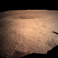
One other comment - the hills on the horizon in the one surface view we have are south of the lander. They are part of the rim of Von Karman, not the central peak. The direction of lighting in the image clearly shows that this must be looking south.
Phil
-------------------- ... because the Solar System ain't gonna map itself.
Also to be found posting similar content on https://mastodon.social/@PhilStooke Maps for download (free PD: https://upload.wikimedia.org/wikipedia/comm...Cartography.pdf NOTE: everything created by me which I post on UMSF is considered to be in the public domain (NOT CC, public domain) |
|
|
|
|
|
|
Jan 3 2019, 08:59 AM
Post
#92
|
|
 Junior Member Group: Members Posts: 98 Joined: 30-November 05 From: Antibes, France Member No.: 594 |
Congratulation to CNSA and the engineers!
 Surprised! I don't see a lot of stones in the first view and the surface seems to be particularly soft with a lot of dust. It looks like dry clay (in a windy day), the kind of clay you find in Roland Garros for instance!  |
|
|
|
|
Jan 3 2019, 09:16 AM
Post
#93
|
|
|
Newbie Group: Members Posts: 7 Joined: 22-September 18 From: Bavaria Member No.: 8456 |
QUOTE (Thorsten Denk @ Jan 2 2019, 07:22 PM)  (3) They will land somewhere else (not Von-Kármán) What makes you think so? In this videoclip (link provided by Explorer1)at 0:21, from looking at the features that's von Kármán crater (I compared with the Virtual Moon atlas). Thomas |
|
|
|
|
Jan 3 2019, 09:33 AM
Post
#94
|
|
 Member Group: Members Posts: 123 Joined: 3-September 12 From: Almeria, SE Spain Member No.: 6632 |
QUOTE (Baywa @ Jan 3 2019, 10:16 AM) What makes you think so? In this videoclip (link provided by Explorer1)at 0:21, from looking at the features that's von Kármán crater (I compared with the Virtual Moon atlas). Thomas It's just one out of five points from a list of possible reasons why the calculations in post #76 are not correct. It was written before the actual landing. Now (after the landing) we know that this point is not the reason. In any case, congratulations to the Chinese for the successful landing!  Thorsten |
|
|
|
|
Jan 3 2019, 10:25 AM
Post
#95
|
|
|
Newbie Group: Members Posts: 7 Joined: 22-September 18 From: Bavaria Member No.: 8456 |
OK - so I mixed up the OR and the AND operator.
 But I would really, really want to figure out what actually happened starting at orbital insertion and ending with the landing approach. For example, maybe they changed the inclination of the orbit? But I would really, really want to figure out what actually happened starting at orbital insertion and ending with the landing approach. For example, maybe they changed the inclination of the orbit?Thomas |
|
|
|
|
Jan 3 2019, 11:03 AM
Post
#96
|
|
|
Senior Member Group: Members Posts: 1074 Joined: 21-September 07 From: Québec, Canada Member No.: 3908 |
Photo of the landing pad on the Moon (link)
|
|
|
|
|
Jan 3 2019, 01:22 PM
Post
#97
|
|
|
Junior Member Group: Members Posts: 27 Joined: 3-January 05 From: Italy Member No.: 134 |
From twitter:
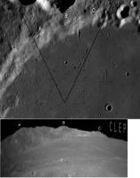
https://twitter.com/Cosmic_Penguin/status/1...6621587456?s=09 "Based on the few descent photos available right now someone in Chinese social media has provided finding charts for #ChangE4. (https://t.co/UiIjI3ngKY) Maybe someone here can get rough landing coordinates of it from the photos below?" Original post on Weibo (Chinese language) https://m.weibo.cn/status/HagktpCG8 |
|
|
|
|
Jan 3 2019, 03:59 PM
Post
#98
|
||
 Member Group: Members Posts: 238 Joined: 15-January 13 Member No.: 6842 |
QUOTE (Phil Stooke @ Jan 3 2019, 08:22 AM) One other comment - the hills on the horizon in the one surface view we have are south of the lander. They are part of the rim of Von Karman, not the central peak. The direction of lighting in the image clearly shows that this must be looking south. Phil
I think the view is towards the largest crater in the immediate vicinity, to the east/south-east of the lander: http://bit.ly/2F5NB9U P.S. QuickMap is strugging to serve so many requests today! -------------------- Curiosity rover panoramas: http://www.facebook.com/CuriosityRoverPanoramas
My Photosynth panoramas: http://photosynth.net/userprofilepage.aspx...;content=Synths |
|
|
|
|
|
|
Jan 3 2019, 04:42 PM
Post
#99
|
|||
 Senior Member Group: Members Posts: 1432 Joined: 26-July 08 Member No.: 4270 |
Yutu 2 deployment.
Attached thumbnail(s)
-------------------- -- Hungry4info (Sirius_Alpha)
|
||
|
|
|
||
|
Jan 3 2019, 05:13 PM
Post
#100
|
|
|
Member Group: Members Posts: 149 Joined: 18-June 08 Member No.: 4216 |
QUOTE (Hungry4info @ Jan 3 2019, 04:42 PM) Yutu 2 deployment. My..that was quick! A somewhat pedantic comment on Phil's earlier remark about viewing directions (Phil, please correct me if I messed up somewhere). It is true that the direction of lighting implies that the mountain ridge on the horizon must be south of the lander and therefore part of the rim of Von Karman, rather than its central peak, but this inference takes also into account the addiitonal knowledge of time of (lunar) day. If the landing were to have taken place near local sunset, witnessing the same shadow direction right after landing would imply a northwards view. Further on the issue of mountains, I recall from looking at pictures of the Von Karman floor posted earlier with the likely location of Ch4 in it that there is a "positive relief feature" just north of the landing site which >should< be closer than either the central peak or the crater rim of VK. It would be interesting to see what that looks like from ground level. Looking forward to those 360 deg panoramas! |
|
|
|
|
Jan 3 2019, 05:18 PM
Post
#101
|
||
|
Newbie Group: Members Posts: 6 Joined: 22-October 09 Member No.: 4990 |
Rover/no-rover
|
|
|
|
|
|
|
Jan 3 2019, 05:38 PM
Post
#102
|
|
 Member Group: Members Posts: 290 Joined: 29-December 05 From: Ottawa, ON Member No.: 624 |
The fact that you can see so far in the distance also indicates they have landed on a slight rise. Reminds me of the view from Stone Mountain on AS16.
|
|
|
|
|
Jan 3 2019, 08:11 PM
Post
#103
|
||
|
Solar System Cartographer Group: Members Posts: 10173 Joined: 5-April 05 From: Canada Member No.: 227 |
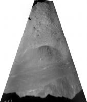
This is my interpretation of the view to the south and the crater rim - south up in the LROC wide angle mosaic. The rim is about 40 km away and the highest peak is 3 km above the plains. I wouldn't say it's 100% certain but I like it better than an interpretation where the relief is a nearby crater. I agree with Steve G that we are on a local rise. Sadly, not enough detail in the middle distance for an exact location yet.
Tolis, you are right about the time determining the direction if you base it on shadows, but we know the landing was mid-morning. Phil
-------------------- ... because the Solar System ain't gonna map itself.
Also to be found posting similar content on https://mastodon.social/@PhilStooke Maps for download (free PD: https://upload.wikimedia.org/wikipedia/comm...Cartography.pdf NOTE: everything created by me which I post on UMSF is considered to be in the public domain (NOT CC, public domain) |
|
|
|
|
|
|
Jan 3 2019, 08:37 PM
Post
#104
|
|
|
Member Group: Members Posts: 156 Joined: 22-May 09 From: Ireland Member No.: 4792 |
From mmatessa's animation, view of the shadows between each - Rover/No Rover - are shortening (note the change at the two small rocks nearby).
The sun is rising over the landed area, so, we must be viewing south as Phil suggests (if elsewise, looking northwards, the shadow changes would be reversed). The 'local sunset' mention may be due to that of viewing the Moon from the Nearside, and anyways, why conduct a mission where the Sun is setting on the Farside, but more when it is rising - availing of its full potential to power-up (using the solar panels) the lander/rover overall. John |
|
|
|
|
Jan 4 2019, 01:59 AM
Post
#105
|
|
|
Senior Member Group: Members Posts: 1276 Joined: 25-November 04 Member No.: 114 |
The pictures posted by China's media look like false color?
Are they using different color filters to bring details out? The moon looks more like mars in the media released images. |
|
|
|
 |

|
Lo-Fi Version | Time is now: 1st June 2024 - 06:57 PM |
|
RULES AND GUIDELINES Please read the Forum Rules and Guidelines before posting. IMAGE COPYRIGHT |
OPINIONS AND MODERATION Opinions expressed on UnmannedSpaceflight.com are those of the individual posters and do not necessarily reflect the opinions of UnmannedSpaceflight.com or The Planetary Society. The all-volunteer UnmannedSpaceflight.com moderation team is wholly independent of The Planetary Society. The Planetary Society has no influence over decisions made by the UnmannedSpaceflight.com moderators. |
SUPPORT THE FORUM Unmannedspaceflight.com is funded by the Planetary Society. Please consider supporting our work and many other projects by donating to the Society or becoming a member. |
|