Home Plate Speculations, Get it in now, before we know the truth! |

Home Plate Speculations, Get it in now, before we know the truth! |
 Jan 25 2006, 04:10 PM Jan 25 2006, 04:10 PM
Post
#1
|
|
 Senior Member  Group: Members Posts: 3419 Joined: 9-February 04 From: Minneapolis, MN, USA Member No.: 15 |
Down in the Front Page Stories board, Phillip asked what all of us UMSF types think Home Plate might be made of and how it was formed. He actually wants Jim Bell's speculations, but asked for UMSF's speculations, as well.
Since we're getting close to getting there, it's time for any of your uninformed speculations out there to be recorded for all posterity...  I posted the following in that thread, but it really belongs here, so I'm reposting it here and inviting discussion. I figure that a lot of us don't bother to read the boards we don't stay actively involved with, so for all of you, this is new. Otherwise, I apologize for the repetitiion! Look at the vertically-exaggerated image posted here. Home Plate seems very obviously, in this stretched image, to be the remnant of an impact crater. There are several impact crater remnants in the inner basin, here. Each seems to have been formed in a surface that was a good many meters higher than the present surface -- those missing several meters have been deflated from this terrain, by some process, leaving the shocked "pedestal" remnants of the deeper cratering forms. Remember, when you make an impact crater, you don't just affect the surface. The disruption caused by the cratering event goes well under the surface, consisting of impact melt (if the impact is energetic enough) and shocked, brecciated rocks. The crater remnants we're seeing on the surface look like the brecciated and shocked rocks that were originally created in a bowl-shaped lining beneath this cluster of impact craters. I can see traces of at least five different craters within the inner basin, here. (The ridge of rock Spirit is passing right now is, in fact, a small crater remnant.) As for Home Plate, it sits within the largest and most well-defined of these crater remnants. Maybe such layers were exhumed in *all* of the craters here, and have since been completely eroded away -- but that doesn't seem right. We have traces of several craters, and in only one of them do we see any trace of this lighter-colored material. I'd have to think that either the impact target composition was different where the Home Plate impact occurred -- which seems a little unlikely when you consider some of these impacts are only a few tens of meters apart -- or that some other substance was deposited in Home Plate crater that wasn't deposited in the other craters. (Or that has been completely deflated from the other craters, if it ever existed there.) So, logic *seems* to point towards post-cratering material deposition accounting for the light-rock ring. Personally, I think it could have been water deposition. Home Plate could have been a puddle that was filled and dried thousands of times (maybe with an internal artesian spring) that resulted in aqueous transport and deposition. Or, it could have just been a good wind trap and it trapped a lot of light-colored dust. Hard to say. I'm not only interested in the light-rock ring's composition, I'm getting very curious about the erosion process that deflated the original surface. Could aeolian erosion have deflated *that* much surface, even over a few billion years? Do we need to postulate aqueous erosion, or even glacial erosion? Maybe the specific composition and erosion patterns we see on the light-rock ring will help us puzzle that out. -the other Doug -------------------- The trouble ain't that there is too many fools, but that the lightning ain't distributed right. -Mark Twain
|
 |
 
|
 |
|
Jan 26 2006, 07:40 AM
Post
#16
|
|
|
Member Group: Members Posts: 236 Joined: 21-June 05 Member No.: 417 |
Thank you, thank you. *bows*

Attached image(s)

|
|
|
|
|
Jan 26 2006, 10:12 AM
Post
#17
|
|
|
Founder Group: Chairman Posts: 14433 Joined: 8-February 04 Member No.: 1 |
Didnt pitchers mound get mentioned by Steve like, a year+ ago?
(not attempting to steal thunder here, but I'm sure he mentioned it) Doug |
|
|
|
|
Jan 26 2006, 10:31 AM
Post
#18
|
|||
 Senior Member Group: Members Posts: 1089 Joined: 19-February 05 From: Close to Meudon Observatory in France Member No.: 172 |
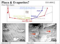
 For your info, excerpts from the 2002 original Gusev presentation at NASA showing "Home Plate" as one of the major features to explore in Gusev, justifying itself a MER landing in Gusev... For your info, excerpts from the 2002 original Gusev presentation at NASA showing "Home Plate" as one of the major features to explore in Gusev, justifying itself a MER landing in Gusev...Enjoy !
Attached thumbnail(s)
|
||
|
|
|
||
|
Jan 26 2006, 01:55 PM
Post
#19
|
|
|
Senior Member Group: Members Posts: 2998 Joined: 30-October 04 Member No.: 105 |
QUOTE (djellison @ Jan 26 2006, 04:12 AM) Didnt pitchers mound get mentioned by Steve like, a year+ ago? (not attempting to steal thunder here, but I'm sure he mentioned it) Doug  At first we were calling this feature "The Cinder Cone" and someone pointed out that the "official" name was "Pitcher's Mound", in keeping with the baseball there. I don't recall whne this was, but it was a while back. Vikingmars, I do recall that the original target at Columbia Hills was the Inner Basin and Homeplate. Do you have a link to the 2002 Gusev presentation that those two images were excerpted from? --Bill -------------------- |
|
|
|
|
Jan 26 2006, 01:59 PM
Post
#20
|
|
 Special Cookie Group: Members Posts: 2168 Joined: 6-April 05 From: Sintra | Portugal Member No.: 228 |
I'm not certain but I have the impression that I first read the name at the Mark Forum...Can't recall who was it...It was you general?...
-------------------- "Ride, boldly ride," The shade replied, "If you seek for Eldorado!"
Edgar Alan Poe |
|
|
|
|
Jan 26 2006, 03:03 PM
Post
#21
|
|
|
Member Group: Members Posts: 236 Joined: 21-June 05 Member No.: 417 |
QUOTE (ustrax @ Jan 26 2006, 02:59 PM) I'm not certain but I have the impression that I first read the name at the Mark Forum...Can't recall who was it...It was you general?... That was me, indeed
|
|
|
|
|
Jan 26 2006, 03:42 PM
Post
#22
|
|
|
Junior Member Group: Members Posts: 98 Joined: 24-November 04 Member No.: 111 |
QUOTE (Bill Harris @ Jan 26 2006, 01:55 PM) At first we were calling this feature "The Cinder Cone" and someone pointed out that the "official" name was "Pitcher's Mound", in keeping with the baseball there. I don't recall whne this was, but it was a while back. "The Cinder Cone" originated from a long thread speculating on what we would find at the space.com boards a while ago. It was a poor but distinctive name since it implied a (almost certainly incorrect) causation. "Pitcher's Mound" is a much better name. My two cents on this: Home Plate is a remnant fossil crater, and it has some evaporite deposts within it. I predict that we will be puzzling how those evaporite deposits became localized and prevalent within this crate remnant. I speculate that ancient cycles of ice deposition at high obliquity (especially when the atmosphere was a bit thicker), followed by subsequent sublimation and maybe possible ephemeral brine formation on very warm days caused the evaporites to concentrate at the surface. We will see! |
|
|
|
|
Jan 26 2006, 05:04 PM
Post
#23
|
|
|
Senior Member Group: Members Posts: 1089 Joined: 19-February 05 From: Close to Meudon Observatory in France Member No.: 172 |
Here are the 2 major links featuring Home Plate (from decisions "end to end") : May 10, 2002 (3rd MER 2003 Workshop where Gusev is 1st closely examined among the 4 remaining sites) http://webgis.wr.usgs.gov/mer/March_2002_p...nal_version.pdf 30 December 2003 (last JGR issue, 5 days before landing on Gusev) http://www.higp.hawaii.edu/~scott/NASA_200..._et_al_2003.pdf Enjoy ! QUOTE (Bill Harris @ Jan 26 2006, 02:55 PM) Vikingmars, I do recall that the original target at Columbia Hills was the Inner Basin and Homeplate. Do you have a link to the 2002 Gusev presentation that those two images were excerpted from?
--Bill |
|
|
|
|
Jan 26 2006, 05:14 PM
Post
#24
|
|
|
Member Group: Members Posts: 242 Joined: 21-December 04 Member No.: 127 |
I'm going to go out on a limb and argue for a sedimentary remnant, perhaps bounded by a crater older than the surrounding lava flows. The walls of the crater protected the sedimentary materials inside from the lava that covered the rest of the ancient lake bed.
|
|
|
|
|
Jan 26 2006, 05:27 PM
Post
#25
|
|
 Member Group: Members Posts: 154 Joined: 17-March 05 Member No.: 206 |
QUOTE Here are the 2 major links featuring Home Plate (from decisions "end to end") :May 10, 2002 (3rd MER 2003 Workshop where Gusev is 1st closely examined among the 4 remaining sites) http://webgis.wr.usgs.gov/mer/March_2002_p...nal_version.pdf Yes, they used an image of the Inner Basin as an arguement (see slide 12 of th epresentation for the photo) as evidence for sedimentary deposit, specifically just above El Dorado. Interesting that what seems obvious from orbit is not the case when we have "ground truth". |
|
|
|
|
Jan 26 2006, 06:33 PM
Post
#26
|
|
|
Senior Member Group: Members Posts: 1636 Joined: 9-May 05 From: Lima, Peru Member No.: 385 |
QUOTE (vikingmars @ Jan 26 2006, 12:04 PM) Here are the 2 major links featuring Home Plate (from decisions "end to end") :May 10, 2002 (3rd MER 2003 Workshop where Gusev is 1st closely examined among the 4 remaining sites) http://webgis.wr.usgs.gov/mer/March_2002_p...nal_version.pdf 30 December 2003 (last JGR issue, 5 days before landing on Gusev) http://www.higp.hawaii.edu/~scott/NASA_200..._et_al_2003.pdf Enjoy ! Vikingmars: Thank you for enjoying us with interesting documents. Rodolfo |
|
|
|
| Guest_Oersted_* |
Jan 26 2006, 06:35 PM
Post
#27
|
|
Guests |
This was my idea back from January 14:
"Possibly out on a limb here, but maybe Home Plate is the source of these thin layers of white material, perhaps salts, that we see just under the surface in the valley. There's no distinct tail of white deposits downwind from Home Plate on the surface. This could be because such deposits are blanketed with darker sands from time to time during dust storms. So, Home Plate could be the source of the white material to the surrounding lower areas. Home Plate itself is higher up, and therefore does not get covered in darker windblown deposits, which rather collect in the eolian cul-de-sacs. Maybe Home Plate protrudes from the valley floor because it is made of a harder material than the surrounding areas. Would this fit together with Home Plate being white due to salts?" |
|
|
|
|
Jan 26 2006, 06:54 PM
Post
#28
|
|
 Senior Member Group: Members Posts: 1229 Joined: 24-December 05 From: The blue one in between the yellow and red ones. Member No.: 618 |
QUOTE (vikingmars @ Jan 26 2006, 07:04 AM) Here are the 2 major links featuring Home Plate (from decisions "end to end") :May 10, 2002 (3rd MER 2003 Workshop where Gusev is 1st closely examined among the 4 remaining sites) http://webgis.wr.usgs.gov/mer/March_2002_p...nal_version.pdf 30 December 2003 (last JGR issue, 5 days before landing on Gusev) http://www.higp.hawaii.edu/~scott/NASA_200..._et_al_2003.pdf Enjoy ! Thanx. I've gone through both documents looking for the names Homeplate and Pitcher's mound without success. I see the features in the orbital photos, but not the names. -------------------- My Grandpa goes to Mars every day and all I get are these lousy T-shirts!
|
|
|
|
|
Jan 26 2006, 07:53 PM
Post
#29
|
|
|
Senior Member Group: Members Posts: 1089 Joined: 19-February 05 From: Close to Meudon Observatory in France Member No.: 172 |
....because at that time, no much was named there, exept the Columbia Hills that were still dubbed "Edmund's Hills" ("Collines d'Edmond") referring to Edmond Grin, working with Nathalie Cabrol, who saw them first in Gusev in 1985 at the University of Paris-Sorbonne and Observatory of Paris-Meudon on Viking Orbiter pictures. Also, he understood their importance for understanding the stratigraphy and history of Gusev. QUOTE (Shaka @ Jan 26 2006, 07:54 PM) I see the features in the orbital photos, but not the names.
|
|
|
|
|
Jan 27 2006, 04:07 AM
Post
#30
|
|
 Senior Member Group: Members Posts: 2228 Joined: 1-December 04 From: Marble Falls, Texas, USA Member No.: 116 |
I couldn't verify the origin of the term "pitcher's mound" for that feature. I did a number of Google searches using their site search feature, searching the MER site, JPL, and the Markcarey forum. It's not important, though. It's a good name, wherever it came from.
After reading the widely diverse opinions of Home Plate's nature here, I can quite confidently predict that once we get there, some of us will be very surprised.
-------------------- ...Tom
I'm not a Space Fan, I'm a Space Exploration Enthusiast. |
|
|
|
 |

|
Lo-Fi Version | Time is now: 4th June 2024 - 12:41 AM |
|
RULES AND GUIDELINES Please read the Forum Rules and Guidelines before posting. IMAGE COPYRIGHT |
OPINIONS AND MODERATION Opinions expressed on UnmannedSpaceflight.com are those of the individual posters and do not necessarily reflect the opinions of UnmannedSpaceflight.com or The Planetary Society. The all-volunteer UnmannedSpaceflight.com moderation team is wholly independent of The Planetary Society. The Planetary Society has no influence over decisions made by the UnmannedSpaceflight.com moderators. |
SUPPORT THE FORUM Unmannedspaceflight.com is funded by the Planetary Society. Please consider supporting our work and many other projects by donating to the Society or becoming a member. |
|