Past Bahia Blanca, onto Cabo Corrientes |

Past Bahia Blanca, onto Cabo Corrientes |
 Feb 8 2007, 06:16 AM Feb 8 2007, 06:16 AM
Post
#1
|
|
|
Member  Group: Members Posts: 233 Joined: 21-April 05 Member No.: 328 |
Tesheiner, I read about the 10K mark, and was hoping that you had updated the route map to show the excursion that put us over the mark -- and you didn't disappoint!
By the way, I'm thinking that Oppy's getting ready to head back to Duck Bay, which looks like the past entry path, plus nice vertical cliffs to examine on the way in . . . |
 |
 
|
 |
|
Feb 18 2007, 10:42 AM
Post
#46
|
||
 The Poet Dude Group: Moderator Posts: 5551 Joined: 15-March 04 From: Kendal, Cumbria, UK Member No.: 60 |
 Where did I put that swear box??!?!?!?! Where did I put that swear box??!?!?!?!
One of the most striking views yet don't you think? LOVE this planet!!! 
-------------------- |
|
|
|
|
|
|
Feb 18 2007, 11:37 AM
Post
#47
|
||
|
Senior Member Group: Members Posts: 2922 Joined: 14-February 06 From: Very close to the Pyrénées Mountains (France) Member No.: 682 |
QUOTE (Stu @ Feb 18 2007, 11:42 AM)  Where did I put that swear box??!?!?!?! Where did I put that swear box??!?!?!?!One of the most striking views yet don't you think? LOVE this planet!!! Clink, clink, clink (clinkber  ) )I agree Stu. There are more : http://qt.exploratorium.edu/mars/opportuni...cam/2007-02-18/ Can't believe how thin last cape looks like. Nice Oppy's tracks near The Dock :
Lot of dark sand too, with some tiny dark "rays" that seams to feed it from above. -------------------- |
|
|
|
|
|
|
Feb 19 2007, 08:46 PM
Post
#48
|
||
|
Senior Member Group: Members Posts: 2837 Joined: 22-April 05 From: Ridderkerk, Netherlands Member No.: 353 |
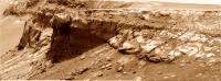
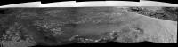
The panoramic view looking back on Sol 1091.
Taken with the L2 Pancam. jvandriel
Attached thumbnail(s)
|
|
|
|
|
|
|
Feb 20 2007, 04:14 PM
Post
#49
|
|
 Member Group: Members Posts: 213 Joined: 21-January 07 From: Wigan, England Member No.: 1638 |
It looks like the puzzling driving as seen around Sol 1078 - 1082 may have been due to the live testing of the Field D* autonav software:
http://www.cmu.edu/news/archive/2007/Febru...13_rovers.shtml |
|
|
|
|
Feb 20 2007, 08:20 PM
Post
#50
|
||
|
Senior Member Group: Members Posts: 2837 Joined: 22-April 05 From: Ridderkerk, Netherlands Member No.: 353 |
Just added 1 image.
The L0 Navcam view on Sol 1089 and Sol 1092. jvandriel
Attached thumbnail(s)
|
|
|
|
|
|
|
Feb 21 2007, 01:47 AM
Post
#51
|
|
 Member Group: Members Posts: 754 Joined: 9-February 07 Member No.: 1700 |
Hello all, I'm a n
 b to UnmannedSpaceflight. A geological beginner's question about the L2 pancam image from Sol1091: Is the prominent ridge creating the shadow considered to be the point-of-impact when the crater was formed in the first place? To what extent has the surface-level diameter of the crater expanded over eons? b to UnmannedSpaceflight. A geological beginner's question about the L2 pancam image from Sol1091: Is the prominent ridge creating the shadow considered to be the point-of-impact when the crater was formed in the first place? To what extent has the surface-level diameter of the crater expanded over eons?
|
|
|
|
|
Feb 21 2007, 05:48 AM
Post
#52
|
|
 Senior Member Group: Members Posts: 2228 Joined: 1-December 04 From: Marble Falls, Texas, USA Member No.: 116 |
Del Palmer: Cool.
-------------------- ...Tom
I'm not a Space Fan, I'm a Space Exploration Enthusiast. |
|
|
|
|
Feb 21 2007, 09:19 AM
Post
#53
|
|
|
Senior Member Group: Members Posts: 2922 Joined: 14-February 06 From: Very close to the Pyrénées Mountains (France) Member No.: 682 |
QUOTE (CosmicRocker @ Feb 21 2007, 06:48 AM) Del Palmer: Cool. Yep, would even be a nice new thread/topic. -------------------- |
|
|
|
|
Feb 21 2007, 09:29 AM
Post
#54
|
|
 Member Group: Members Posts: 559 Joined: 1-May 06 From: Scotland (Ecosse, Escocia) Member No.: 759 |
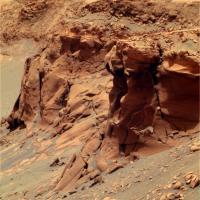
Interesting little rock at the right side of this image. It appears dark in this filter, but light in the other 2.
1092 PanCam |
|
|
|
|
Feb 21 2007, 11:27 AM
Post
#55
|
|
|
Senior Member Group: Moderator Posts: 4279 Joined: 19-April 05 From: .br at .es Member No.: 253 |
Opportunity moved on sol 1094 a few meters to a new location. New pics at the exploratorium.
We can clearly see "Hoy" in this navcam image: http://nasa.exploratorium.edu/mars/opportu...R1P0655L0M1.JPG |
|
|
|
|
Feb 22 2007, 11:15 AM
Post
#56
|
||
|
Senior Member Group: Moderator Posts: 4279 Joined: 19-April 05 From: .br at .es Member No.: 253 |
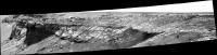
Roving, roving, roving...
 Our little friend moved to almost the other side of the cape few hours ago during sol 1095 and took this 180º navcam mosaic looking north. Bahia Blanca is to the left (west) and cape/bay C3 to the right (east).
|
|
|
|
|
|
|
Feb 22 2007, 04:11 PM
Post
#57
|
|
|
Member Group: Members Posts: 242 Joined: 17-February 04 From: Ohio, USA Member No.: 34 |
Brellis
I'll attempt to provide an answer to your questions. Others may correct me. The initial point of impact of the bolide that formed Victoria crater would have been destroyed in the explosion generated by the impact. The ridge that is visible in the middle background of the sol 1091 panorama has been called "the dock" in this forum and "Guam" by the follks at NASA. As far as I know, there has been no 'official' statement of it's origin. The scalloped nature of Victoria's perimeter strongly suggests that some erosion has taken place since it's formation. How much erosion has occurred has been the subject of some debate. |
|
|
|
|
Feb 24 2007, 11:54 AM
Post
#58
|
||
|
The Poet Dude Group: Moderator Posts: 5551 Joined: 15-March 04 From: Kendal, Cumbria, UK Member No.: 60 |
GORGEOUS views today...
-------------------- |
|
|
|
|
|
|
Feb 24 2007, 01:45 PM
Post
#59
|
||
|
Senior Member Group: Members Posts: 2837 Joined: 22-April 05 From: Ridderkerk, Netherlands Member No.: 353 |
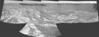
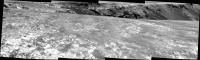
The view in the drive direction on Sol 1094.
Taken with the L2 Pancam. jvandriel
Attached thumbnail(s)
|
|
|
|
|
|
|
Feb 24 2007, 02:17 PM
Post
#60
|
||
|
Senior Member Group: Members Posts: 2837 Joined: 22-April 05 From: Ridderkerk, Netherlands Member No.: 353 |
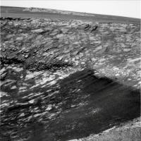
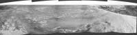
Opportunity looking back on Sol 1095.
Taken with the L0 Navcam. jvandriel
Attached thumbnail(s)
|
|
|
|
|
|
 |

|
Lo-Fi Version | Time is now: 8th June 2024 - 07:42 AM |
|
RULES AND GUIDELINES Please read the Forum Rules and Guidelines before posting. IMAGE COPYRIGHT |
OPINIONS AND MODERATION Opinions expressed on UnmannedSpaceflight.com are those of the individual posters and do not necessarily reflect the opinions of UnmannedSpaceflight.com or The Planetary Society. The all-volunteer UnmannedSpaceflight.com moderation team is wholly independent of The Planetary Society. The Planetary Society has no influence over decisions made by the UnmannedSpaceflight.com moderators. |
SUPPORT THE FORUM Unmannedspaceflight.com is funded by the Planetary Society. Please consider supporting our work and many other projects by donating to the Society or becoming a member. |
|