InSight mission |

InSight mission |
 Jan 7 2012, 08:29 PM Jan 7 2012, 08:29 PM
Post
#1
|
|
 Senior Member  Group: Members Posts: 1729 Joined: 3-August 06 From: 43° 35' 53" N 1° 26' 35" E Member No.: 1004 |
the GEMS Discovery finalist has been renamed InSight and now has its own website: http://insight.jpl.nasa.gov/
|
 |
 
|
 |
|
Jan 7 2012, 09:33 PM
Post
#2
|
|
|
Senior Member Group: Members Posts: 1018 Joined: 29-November 05 From: Seattle, WA, USA Member No.: 590 |
I was going to say I was amazed that we've reached the point where a Mars lander can be attempted on a Discovery budget. Then I found out that Pathfinder did it too: http://www.marsnews.com/missions/pathfinder/ That got me to wondering how much progress we've made in 20 years. I note that InSight should weigh about 350 kg--almost exactly the same as Pathfinder did.
A side-by-side comparison is a little tough, since InSight is about studying the interior of Mars while Pathfinder was focused on the surface. Also, the info on Insight is a little sketchy (from what I could find). A lot of it's derived from Phoenix, so that's a start I guess. --Greg |
|
|
|
|
Jan 8 2012, 12:26 AM
Post
#3
|
|
|
Member Group: Members Posts: 706 Joined: 22-April 05 Member No.: 351 |
QUOTE (Greg Hullender @ Jan 7 2012, 01:33 PM)  I was going to say I was amazed that we've reached the point where a Mars lander can be attempted on a Discovery budget. Phoenix could fit into a Discovery budget only because the lander and instruments were mostly built. It turned out that the development team had to do a lot of testing and modification to the original design, but they had a solid starting place. With the Phoenix lander a proven design, InSight can reuse it and hopefully fit within a Discovery budget. -------------------- |
|
|
|
|
Jan 8 2012, 01:47 AM
Post
#4
|
|
|
Merciless Robot Group: Admin Posts: 8784 Joined: 8-December 05 From: Los Angeles Member No.: 602 |
Hmm. I read through the site & the poster, and saw no mention at all of any sort of cameras.
-------------------- A few will take this knowledge and use this power of a dream realized as a force for change, an impetus for further discovery to make less ancient dreams real.
|
|
|
|
|
Jan 8 2012, 01:50 AM
Post
#5
|
|
|
Senior Member Group: Members Posts: 1018 Joined: 29-November 05 From: Seattle, WA, USA Member No.: 590 |
Oh I definitely love the idea of building new probes on proven platforms. I'm just wondering how much more advanced the instruments are now. I realize that's hard to quantify. Maybe just stats like GHz, megabytes, and bits-per-second would be enough. It just seemed that we're putting the same amount of mass on Mars as we did 20 years ago, but I'll bet we're getting 100x the data.
--Greg |
|
|
|
|
Jan 8 2012, 07:07 AM
Post
#6
|
|
|
Member Group: Members Posts: 706 Joined: 22-April 05 Member No.: 351 |
QUOTE (nprev @ Jan 7 2012, 05:47 PM) I read through the site & the poster, and saw no mention at all of any sort of cameras. I believe the only camera is on the arm that deploys two of the instruments. It might also be able to be used for a panorama, but its primary use is to examine the area within reach and to determine where to place the seismometer and heat probe. This is a stripped down mission carrying only the instruments essential to the geophysical questions. If they were to do an added capability for outreach, my vote would be to carry the duplicate of the Sojourner rover (with new CCDs for the cameras). -------------------- |
|
|
|
|
Jan 8 2012, 03:12 PM
Post
#7
|
|
|
Member Group: Members Posts: 293 Joined: 22-September 08 From: Spain Member No.: 4350 |
Is there a big difference between this mission and the canceled payload for the Exomars lander?
|
|
|
|
|
Jan 8 2012, 05:11 PM
Post
#8
|
|
|
Founder Group: Chairman Posts: 14432 Joined: 8-February 04 Member No.: 1 |
QUOTE (vjkane @ Jan 7 2012, 11:07 PM) If they were to do an added capability for outreach, my vote would be to carry the duplicate of the Sojourner rover (with new CCDs for the cameras). New CCD's means new backend electronics, new storage, new CPU, new radios.....basically, a new rover. It would cost a fortune. I adore Marie Curie - but bolting it onto InSight and deploying it 2001 style would be a bad idea. Moreover - without a stereo camera onboard InSight itself - you don't have the 3D terrain data on which to plan the driving. |
|
|
|
|
Jan 8 2012, 05:32 PM
Post
#9
|
|
|
Solar System Cartographer Group: Members Posts: 10166 Joined: 5-April 05 From: Canada Member No.: 227 |
One additional point about cameras... it is essential to know the exact location of a lander - the interpretation of seismic and heat flow data will be very much tied in with knowing what it landed on. Phoenix was located with HiRISE images but we can't guarantee the availability of images with that resolution in 2016. So precise location will depend, at least as a back-up, on locating the lander with respect to horizon features. So some degree of ability to survey the site will be necessary to guarantee the quality of the science. For Phoenix, the RAC camera on the arm was not used as a site-mapping instrument (except underneath the lander), but it could have been, if necessary.
Phil -------------------- ... because the Solar System ain't gonna map itself.
Also to be found posting similar content on https://mastodon.social/@PhilStooke Maps for download (free PD: https://upload.wikimedia.org/wikipedia/comm...Cartography.pdf NOTE: everything created by me which I post on UMSF is considered to be in the public domain (NOT CC, public domain) |
|
|
|
|
Jan 8 2012, 06:08 PM
Post
#10
|
|
|
Member Group: Members Posts: 706 Joined: 22-April 05 Member No.: 351 |
QUOTE (djellison @ Jan 8 2012, 09:11 AM) I adore Marie Curie - but bolting it onto InSight and deploying it 2001 style would be a bad idea. And there would be the cost of requalifying now 'ancient' parts for flight for which spares may be hard to find. So I mentioned it as a what if day dream, not as a realistic proposal. Also, I've heard that the goal is to put the lander down in flat, boring landscape to ensure a safe landing, so there is likely to be relatively little to see or for a small rover to poke around in. Still, it would have been nice for Marie Curie to eventually make it to Mars. As for the question of how InSight compares to the cancelled ExoMars geophysical station, a quick search on Google didn't bring up the latter's instrument list. However, as I remember, it was fairly extensive, more so than InSight. InSight is a tightly focused proposal that does less than most proposals for Mars geophysical stations/networks. That focus gives probably gives it a better shot at flying than previous proposals, none of which flew. -------------------- |
|
|
|
|
Jan 8 2012, 06:34 PM
Post
#11
|
|
|
Member Group: Members Posts: 706 Joined: 22-April 05 Member No.: 351 |
QUOTE (Phil Stooke @ Jan 8 2012, 09:32 AM) One additional point about cameras... it is essential to know the exact location of a lander - the interpretation of seismic and heat flow data will be very much tied in with knowing what it landed on. I haven't seen this discussed, but they may have a descent camera to meet this need. Phoenix carried a descent camera that wasn't used because, if memory serves me correctly, software issues discovered in flight. The InSight mission could make the necessary changes. -------------------- |
|
|
|
|
Jan 8 2012, 06:59 PM
Post
#12
|
|
|
Senior Member Group: Members Posts: 1018 Joined: 29-November 05 From: Seattle, WA, USA Member No.: 590 |
Here's a completely different question: to get earthquake locations, don't you need three, separated seismic stations? Without location, you don't really have magnitude, do you? What will InSight be able to tell us?
--Greg |
|
|
|
|
Jan 8 2012, 07:03 PM
Post
#13
|
|
|
Founder Group: Chairman Posts: 14432 Joined: 8-February 04 Member No.: 1 |
You don't need a descent imager to exactly locate a spacecraft on the surface of Mars. We have HiRISE for that.
|
|
|
|
|
Jan 8 2012, 07:23 PM
Post
#14
|
|
|
Solar System Cartographer Group: Members Posts: 10166 Joined: 5-April 05 From: Canada Member No.: 227 |
But we may not have it in 2016. Almost certainly it will land in an area of HiRISE coverage, but surface images may still be needed, as a backup if there is no working HiRISE, to match the site with the orbital images. Without images the best we can expect to locate it would be within 1 or 2 km, but it's still useful to know if you are on a small crater's ejecta deposit, or on one side or the other of a terrain boundary or sediment deposit.
I wondered about a descent camera as well. That would be useful, indeed. I seem to recall the problem last time was about moving the descent camera data into the spacecraft computer during a critical time. Hopefully the next descent camera will have its own memory to make that data transfer unnecessary. Phil -------------------- ... because the Solar System ain't gonna map itself.
Also to be found posting similar content on https://mastodon.social/@PhilStooke Maps for download (free PD: https://upload.wikimedia.org/wikipedia/comm...Cartography.pdf NOTE: everything created by me which I post on UMSF is considered to be in the public domain (NOT CC, public domain) |
|
|
|
|
Jan 8 2012, 07:34 PM
Post
#15
|
|
|
Member Group: Members Posts: 293 Joined: 29-August 06 From: Columbia, MD Member No.: 1083 |
QUOTE (Greg Hullender @ Jan 8 2012, 01:59 PM) Here's a completely different question: to get earthquake locations, don't you need three, separated seismic stations? Without location, you don't really have magnitude, do you? What will InSight be able to tell us? --Greg All of the previous Mars network mission concepts, which are focused on interior structure as well, rely on multiple stations so they can triangulate locations in the interior and get a better 3-D picture of the structure. From what I've been told and heard at conferences, InSight will STRONGLY rely on modeling to validate it's measurements. InSight seems to have the inside track as the low-risk option of the 3 finalists, but they need to make the case that their results will be robust when they're depending on modeling to interpret their signal. |
|
|
|
|
Jan 9 2012, 07:40 PM
Post
#16
|
|
 Director of Galilean Photography Group: Members Posts: 896 Joined: 15-July 04 From: Austin, TX Member No.: 93 |
I think they're some work you can do with direct vs reflected signals to determine distance and range. Also, P and S waves travel at different velocities, assuming their seismograph is sensitive enough, they could roughly determine distance that way. This would, however, not let them determine depth of the hypocenter, unless there's some other aspect they can model.
It really is a shame this will probably be a one-off. Too bad a pair of DS2 seismographs couldn't be dropped off the deck as is falls, even if they land just a few km away they could help with triangulation. #include <doug_rant_on_tradeoffs.h> -------------------- Space Enthusiast Richard Hendricks
-- "The engineers, as usual, made a tremendous fuss. Again as usual, they did the job in half the time they had dismissed as being absolutely impossible." --Rescue Party, Arthur C Clarke Mother Nature is the final inspector of all quality. |
|
|
|
|
Jan 9 2012, 08:50 PM
Post
#17
|
|
 Senior Member Group: Admin Posts: 4763 Joined: 15-March 05 From: Glendale, AZ Member No.: 197 |
QUOTE (Greg Hullender @ Jan 8 2012, 10:59 AM) Without location, you don't really have magnitude, do you? Actually you do. Because earthquakes generate three distinct types of waves that travel at different rates a lone seismometer can be used to calculate absolute distance to the focus (or center) of the event and magnitude as well. The only problem is direction. However if you have TWO sufficiently sensitive devices you can calculate the location by first identifying the two intersecting nodes, and then using secondary reflected events to isolate one of the two nodes as the event location. In fact the Viking landers had seismometers for this very purpose, however one of them malfunctioned (forget which right now). -------------------- If Occam had heard my theory, things would be very different now.
|
|
|
|
|
Jan 9 2012, 09:25 PM
Post
#18
|
|
|
Member Group: Members Posts: 252 Joined: 5-May 05 From: Mississippi (USA) Member No.: 379 |
Warning I am not a geologist.
My impression, when I read a short explanation of the mission, was that they were only trying to measure the planets seismic energy. You don't need direction and maybe not even distance for that. Mars doesn't have plate tectonics, as far as I have heard, and I guess the level of seismic energy will say something about the planets core. Jack |
|
|
|
|
Jan 10 2012, 02:44 AM
Post
#19
|
|
|
Member Group: Members Posts: 315 Joined: 1-October 06 Member No.: 1206 |
QUOTE Too bad a pair of DS2 seismographs couldn't be dropped off the deck as is falls Exactly what I was thinking! Its too bad that penetrator technology seems to have gone nowhere since then, and Im not just talking about for Mars. Still, here we all are musing about bolting stuff onto a Discovery class proposal, stuff that wouldnt make it a Discovery class proposal any more. That cap is why I love TiME so much, assuming they CAN actually fly the thing under the cap... P |
|
|
|
|
Jan 10 2012, 03:34 PM
Post
#20
|
|
|
Member Group: Members Posts: 206 Joined: 15-August 07 From: Shrewsbury, Shropshire Member No.: 3233 |
I assume that there is a mission assumption is that the solar panels will continue to suppy power for much more than 90 days. I understand that the Pathfinder lander only lasted 90 days because of a complete lack of cleaning winds. The question that I want to ask is how common are cleaning winds on Mars? Perhaps the only safe landing site for the InSight mission is the Opportunity landing elipse? At least there cleaning winds are guaranteed.
I also wonder how much of its potential payload mass this mission is using? Would it really cost anything for the odd Phoenix instrument to be reflown? I would like to see Lidar reflown to a landing site where it could operate for longer than a very limited 150 days. Obviously the most important missing instrument is a camera to scan the horizon. Would a pair of black and white Navcams cost much to fly? I guess that Navcams are two a penny given the number of spare Navcams that are flying on MSL. |
|
|
|
|
Jan 10 2012, 03:42 PM
Post
#21
|
|
|
Member Group: Members Posts: 293 Joined: 29-August 06 From: Columbia, MD Member No.: 1083 |
I'm guessing the mission is more cost-limited than mass-limited. To fit the Discovery cost cap, they can't fly any more instruments. Even if an instrument was donated by a foreign agency or NASA wanted to fly a camera for purely PR purposes, there are mission financial costs associated with that that could be counted against InSight's cost cap.
|
|
|
|
|
Jan 10 2012, 03:42 PM
Post
#22
|
|
|
Founder Group: Chairman Posts: 14432 Joined: 8-February 04 Member No.: 1 |
QUOTE (PaulM @ Jan 10 2012, 07:34 AM) . I understand that the Pathfinder lander only lasted 90 days because of a complete lack of cleaning winds. No- the battery died. It was a silver-zinc battery, and couldn't withstand the manifold charging cycles that more recent technologies can. Estimate were between 30 and 100 recharges would be the end of it. It lasted 83 sols (not 90) Thereafter, the lander couldn't keep itself warm at night, and presumed failures of other components quickly followed. The Level 1 requirement was a month. |
|
|
|
|
Mar 23 2012, 01:06 PM
Post
#23
|
|
|
Solar System Cartographer Group: Members Posts: 10166 Joined: 5-April 05 From: Canada Member No.: 227 |
A few new details about the mission, from Bruce Banerdt at LPSC.
The spacecraft carries a MER hazcam (maybe 2) fixed on the body to give an overview of the instrument deployment area, and a MER navcam (or a pair, more likely) on the arm elbow area for detailed instrument deployment coverage. After instrument deployment, but during the first 60 days, they will use the navcam(s) to do a full panorama and other things like change detection (which might include clouds, dust devils etc.) . Then they go to reduced operations for the rest of the mission, only monitoring the instruments. Phil -------------------- ... because the Solar System ain't gonna map itself.
Also to be found posting similar content on https://mastodon.social/@PhilStooke Maps for download (free PD: https://upload.wikimedia.org/wikipedia/comm...Cartography.pdf NOTE: everything created by me which I post on UMSF is considered to be in the public domain (NOT CC, public domain) |
|
|
|
|
Mar 28 2012, 11:03 AM
Post
#24
|
|
 Senior Member Group: Members Posts: 1088 Joined: 19-February 05 From: Close to Meudon Observatory in France Member No.: 172 |
QUOTE (PaulM @ Jan 10 2012, 04:34 PM) I understand that the Pathfinder lander only lasted 90 days because of a complete lack of cleaning winds. Well. No : mainly because of a main battery failure which changed the time set on the onboard clock... No more energy storage + no more onboard time = no more tasks doable in a proper order = end of telecoms = end of mission ! |
|
|
|
|
Aug 20 2012, 07:01 PM
Post
#25
|
|
 Junior Member Group: Members Posts: 50 Joined: 14-January 07 From: France Member No.: 1602 |
|
|
|
|
|
Aug 20 2012, 07:18 PM
Post
#26
|
|
 Senior Member Group: Members Posts: 1431 Joined: 26-July 08 Member No.: 4270 |
Awesome! Mars! I can't remember the last time we landed there!
-------------------- -- Hungry4info (Sirius_Alpha)
|
|
|
|
|
Aug 20 2012, 07:55 PM
Post
#27
|
|
|
Solar System Cartographer Group: Members Posts: 10166 Joined: 5-April 05 From: Canada Member No.: 227 |
Good one, Hungry! I would have liked any of them but I'm especially interested in this one.
Phil -------------------- ... because the Solar System ain't gonna map itself.
Also to be found posting similar content on https://mastodon.social/@PhilStooke Maps for download (free PD: https://upload.wikimedia.org/wikipedia/comm...Cartography.pdf NOTE: everything created by me which I post on UMSF is considered to be in the public domain (NOT CC, public domain) |
|
|
|
|
Aug 20 2012, 08:41 PM
Post
#28
|
|
|
Senior Member Group: Members Posts: 1729 Joined: 3-August 06 From: 43° 35' 53" N 1° 26' 35" E Member No.: 1004 |
press release New NASA Mission to Take First Look Deep Inside Mars
|
|
|
|
|
Aug 20 2012, 09:24 PM
Post
#29
|
|
|
Senior Member Group: Members Posts: 1729 Joined: 3-August 06 From: 43° 35' 53" N 1° 26' 35" E Member No.: 1004 |
interesting... the German heat probe "mole" will be based on Beagle 2's PLUTO mole
http://www.dlr.de/irs/en/desktopdefault.as...970_read-25032/ |
|
|
|
|
Aug 20 2012, 09:26 PM
Post
#30
|
|
|
Founder Group: Chairman Posts: 14432 Joined: 8-February 04 Member No.: 1 |
That's cool - PLUTO was an awesome and cunning little piece of kit.
|
|
|
|
|
Aug 21 2012, 05:25 AM
Post
#31
|
|
 Member Group: Members Posts: 813 Joined: 8-February 04 From: Arabia Terra Member No.: 12 |
Does seem like a shame that only one copy of this spacecraft will fit into the Discovery cost envelope. A seismometer network would provide some very interesting data.
|
|
|
|
|
Aug 21 2012, 07:37 AM
Post
#32
|
|
 Member Group: Members Posts: 648 Joined: 9-May 05 From: Subotica Member No.: 384 |
From Bruce Betts blog on PS...
QUOTE The lander will have black and white cameras on the robotic arm, one similar to the Navcam on the Mars Exploration Rovers and one similar to their Hazcams. They will be used for context and directing the placement of the seismic and heat flow instruments. Yeah...those would be some exciting images to show to the press on their first and only press conference. How do they mean to keep the public interest, if the can't snap at least one 360 degrees, Full Color Hi-resolution panorama of landing site. Maybe this is not final spacecraft design yet? Maybe there is some place for one of these beauties or that Planetary Society's Mars Microphone. and BTW. Is there a word about where it should be landing? -------------------- The scientist does not study nature because it is useful; he studies it because he delights in it, and he delights in it because it is beautiful.
Jules H. Poincare My "Astrophotos" gallery on flickr... |
|
|
|
|
Aug 21 2012, 08:05 AM
Post
#33
|
|
|
Member Group: Members Posts: 184 Joined: 2-March 06 Member No.: 692 |
and BTW. Is there a word about where it should be landing? [/quote] This is a good question. Do you aim at an average safe area of mars, or go for tharsis looking for heat from the interior and quakes? |
|
|
|
|
Aug 21 2012, 08:11 AM
Post
#34
|
|
 Member Group: Members Posts: 259 Joined: 23-January 05 From: Seattle, WA Member No.: 156 |
Given the high elevation at Tharsis, I'd guess you don't go there, especially if you're using Phoenix heritage equipment. That's what the illustration suggests.
|
|
|
|
|
Aug 21 2012, 08:23 AM
Post
#35
|
|
|
Senior Member Group: Members Posts: 2086 Joined: 13-February 10 From: Ontario Member No.: 5221 |
Maybe Elysium instead? Oh, what I'd give to finally see a martian volcano from the surface, no matter how distant....
And yes, a color camera should get some serious consideration. I mean Phoenix had one, so why downgrade? |
|
|
|
|
Aug 21 2012, 10:09 AM
Post
#36
|
|
|
Member Group: Members Posts: 315 Joined: 1-October 06 Member No.: 1206 |
I was thinking Elysium as well, but Elysium PLANITIA
 I think they are going to go for a nice flat and featureless site (sight?). They are taking a Phoenix weather package with them I believe, including that telltale that was sich a cute feature of that mission. P |
|
|
|
|
Aug 21 2012, 10:37 AM
Post
#37
|
|
|
Forum Contributor Group: Members Posts: 1372 Joined: 8-February 04 From: North East Florida, USA. Member No.: 11 |
Forget pretty pics, the science is literally underground.
QUOTE (antipode @ Aug 21 2012, 10:09 AM) They are taking a Phoenix weather package with them I believe, including that telltale that was sich a cute feature of that mission. P You sure about that, no mention of that on the website. |
|
|
|
|
Aug 21 2012, 10:56 AM
Post
#38
|
|
|
Member Group: Members Posts: 293 Joined: 29-August 06 From: Columbia, MD Member No.: 1083 |
QUOTE (antipode @ Aug 21 2012, 06:09 AM) They are taking a Phoenix weather package with them I believe, Don't think so. |
|
|
|
|
Aug 21 2012, 10:57 AM
Post
#39
|
|
|
Member Group: Members Posts: 212 Joined: 19-July 05 Member No.: 442 |
QUOTE (SFJCody @ Aug 21 2012, 01:25 PM) Does seem like a shame that only one copy of this spacecraft will fit into the Discovery cost envelope. A seismometer network would provide some very interesting data. I agree, three landings would give them the chance to use earthquakes & impacts to probe the interior of Mars in the same way Apollo allowed us to determine what was underneath the surface of the Moon. As to the suggestion that they fit something like the weather mast used on Phoenix, they'd also need a camera to monitor it. |
|
|
|
|
Aug 21 2012, 11:34 AM
Post
#40
|
|
|
Forum Contributor Group: Members Posts: 1372 Joined: 8-February 04 From: North East Florida, USA. Member No.: 11 |
QUOTE (gndonald @ Aug 21 2012, 11:57 AM) I agree, three landings would give them the chance to use earthquakes & impacts to probe the interior of Mars in the same way Apollo allowed us to determine what was underneath the surface of the Moon. As to the suggestion that they fit something like the weather mast used on Phoenix, they'd also need a camera to monitor it. New techniques don't require 3 landers, they can do the science with one, thats why they have been given the go ahead for the mission. |
|
|
|
|
Aug 21 2012, 11:35 AM
Post
#41
|
|
 Member Group: Members Posts: 133 Joined: 29-January 05 Member No.: 161 |
Good news from NASA's Mars program at last!
InSight mission page Launch March 8 - March 27, 2016 Seismic package, 5m deep drill, and two cameras! -------------------- |
|
|
|
|
Aug 21 2012, 11:55 AM
Post
#42
|
|
|
Member Group: Members Posts: 153 Joined: 4-May 11 From: Pardubice, CZ Member No.: 5979 |
QUOTE (cIclops @ Aug 21 2012, 01:35 PM) Seismic package, 5m deep drill, and two cameras! Just a little note: HP3 instrument doesn't have a drill, but so-called electromechanical mole which penetrates through the soil via hammering mechanism. For more see http://www.dlr.de/irs/en/desktopdefault.as...970_read-25032/ |
|
|
|
|
Aug 21 2012, 12:19 PM
Post
#43
|
|
 Senior Member Group: Members Posts: 2173 Joined: 28-December 04 From: Florida, USA Member No.: 132 |
|
|
|
|
|
Aug 21 2012, 03:00 PM
Post
#44
|
|
|
Solar System Cartographer Group: Members Posts: 10166 Joined: 5-April 05 From: Canada Member No.: 227 |
There was a poster on the landing site at LPSC in March. I spoke to Bruce about it at the time.
The site has to be low elevation for EDL and near the equator for good solar power throughout the mission. Matt Golombek and colleagues identified suitable areas in Valles Marineris, the southern Chryse channel areas (well south of Chryse itself), Isidis and Elysium Planitia. Only the last area worked well for their needs, especially latitude. They identified about a dozen ellipses and chose one at the centre of the area as a starting point for the proposal. Now they will do a detailed analysis with HiRISE to pick the best one. One drawback - it's not far from Gale and may have some communication overlap issues (Gale itself was chosen partly to avoid that overlap with Opportunity, as all other MSL sites were near Opportunity's longitude). But that can be dealt with. And about cameras - I think they plan to use off the shelf spares of MER Hazcam and Navcam to save money. So changes are out unless you fancy doing a Kickstarter for them. And the cameras are only needed for characterization and documentation for instrument deployment - nice flat area for the seismometer and a suitable spot for the drill. After that they will collect a full panorama for outreach and site context, but then (after about 60 days) they are shut off to save money - allowing a smaller team to simply monitor the other data rather than construct data collection sequences all the time. Everything is going to be about keeping costs down. Phil -------------------- ... because the Solar System ain't gonna map itself.
Also to be found posting similar content on https://mastodon.social/@PhilStooke Maps for download (free PD: https://upload.wikimedia.org/wikipedia/comm...Cartography.pdf NOTE: everything created by me which I post on UMSF is considered to be in the public domain (NOT CC, public domain) |
|
|
|
|
Aug 21 2012, 03:11 PM
Post
#45
|
|
|
Member Group: Members Posts: 293 Joined: 29-August 06 From: Columbia, MD Member No.: 1083 |
QUOTE (cIclops @ Aug 21 2012, 06:35 AM) I've seen similar comments swirling around (even by the NASA Administrator), but this is a Discovery mission, NOT part of NASA's separate Mars program. NASA's planetary science division is currently broken down in the following budgetary and organizational lines: Lunar Quest, Mars, Discovery, New Frontiers, Outer Planets, Technology, Research. |
|
|
|
|
Aug 21 2012, 09:07 PM
Post
#46
|
|
 Senior Member Group: Members Posts: 2530 Joined: 20-April 05 Member No.: 321 |
Mars Geophysical network options with anywhere from 1 to 4 stations have been studied. This passage seems to say it all:
"Although a network of four or more stations would be ideal, fewer stations could still provide much of the necessary information for addressing the science objectives described above. There are many analysis techniques that have been developed for seismology, particularly in the last decade that could extract interior information from seismic measurements at fewer stations, or even a single station. One seismic station could use techniques such as P-S/back-azimuth tracing to provide locations, multiple phase arrivals (P, S, PmP, PcP, PKP, etc.) to derive interior velocities and boundary depths, receiver function and surface wave analysis to delineate crust and upper mantle structure, and Phobos tide measurements and possibly normal mode observations to constrain core size and state. Two stations constitute a substantial improvement in capability, providing correlation capacity for unambiguous identification of seismic events, an improved ability to compute surface wave phase velocity, and noise correlation techniques that can provide planetary structure from background noise analysis while strengthening the interpretation of the single-station techniques described above. A three-station network has the additional advantage that it could provide event locations using conventional P-wave arrival techniques combined with a limited set of a priori assumptions. For this study a two-station network of seismometers is considered the minimum network size to address the baseline science of MGN for a New Frontiers class mission. However, single station missions were also investigated, as they would provide science value commensurate with Discovery class missions." Source: http://ia700504.us.archive.org/26/items/Ma...tions-Final.pdf |
|
|
|
|
Aug 21 2012, 11:31 PM
Post
#47
|
|
|
Member Group: Members Posts: 706 Joined: 22-April 05 Member No.: 351 |
A Universe Today article stated that the landing site will be in Elysium Planitia: Our planned landing site is in Elysium Planitia, Banerdt told me. It was chosen for optimizing engineering safety margins for landing and power.
In emails with Banerdt, he told me that the lander will carry some meteorology instruments to characterize the effect of wind and temperature on the seismic instrument. -------------------- |
|
|
|
|
Aug 21 2012, 11:45 PM
Post
#48
|
|
|
Member Group: Members Posts: 293 Joined: 29-August 06 From: Columbia, MD Member No.: 1083 |
QUOTE (vjkane @ Aug 21 2012, 07:31 PM) In emails with Banerdt, he told me that the lander will carry some meteorology instruments to characterize the effect of wind and temperature on the seismic instrument. Thanks for confirming that. That met data is basically engineering data aka "noise". But, hopefully it can be useful scientifically as well. |
|
|
|
|
Aug 22 2012, 02:38 AM
Post
#49
|
|
 Member Group: Members Posts: 107 Joined: 29-January 09 Member No.: 4589 |
I suppose that (re)flying the Planetary Society's Mars mike is out of the question?
-------------------- Protein structures and Mars fun - http://www.flickr.com/photos/nick960/
|
|
|
|
|
Aug 22 2012, 06:46 AM
Post
#50
|
|
 Member Group: Members Posts: 239 Joined: 18-December 07 From: New York Member No.: 3982 |
Any word on a launch vehicle? An Atlas V seems kind of overkill.
|
|
|
|
|
Aug 22 2012, 06:52 AM
Post
#51
|
|
|
Senior Member Group: Members Posts: 2921 Joined: 14-February 06 From: Very close to the Pyrénées Mountains (France) Member No.: 682 |
QUOTE (NickF @ Aug 22 2012, 04:38 AM) I suppose that (re)flying the Planetary Society's Mars mike is out of the question? May be not: http://www.planetary.org/blogs/bill-nye/we...rs-in-2016.html Read last Bill Nye sentence 
-------------------- |
|
|
|
|
Aug 22 2012, 07:33 AM
Post
#52
|
|
|
Senior Member Group: Members Posts: 1729 Joined: 3-August 06 From: 43° 35' 53" N 1° 26' 35" E Member No.: 1004 |
cool video on the German heat probe
http://www.dlr.de/dlr/en/Portaldata/1/Reso...hp3_640x320.mp4 |
|
|
|
|
Aug 22 2012, 04:32 PM
Post
#53
|
|
 Member Group: Members Posts: 723 Joined: 13-June 04 Member No.: 82 |
QUOTE (briv1016 @ Aug 22 2012, 07:46 AM) Any word on a launch vehicle? An Atlas V seems kind of overkill. It occurs to me that the Falcon 9 has a TMI mass capability of approximately 2,500 kg. Given the Mars InSight lander mass of 350 kg (and maybe double that amount for the cruse stage plus EDL hardware plus lander), you could launch 3 Mars InSight spacecraft to Mars for $50 million. How much extra would it cost to produce two extra flight-ready copies of the InSight spacecraft? (Remember that you just saved $50 million in launch costs over a Delta IV.) I am sure that it would cost more than $50 million to manufacture and test two extra copies, but it still sounds like a bargain to me. I imagine that the total cost would still exceed the Discovery cost cap, though. But even if you only send one copy, you would still have an extra $50 million saved by moving from Delta IV to Falcon 9, which could be used to upgrade the spacecraft. |
|
|
|
|
Aug 22 2012, 11:42 PM
Post
#54
|
|
|
Member Group: Members Posts: 813 Joined: 8-February 04 From: Arabia Terra Member No.: 12 |
QUOTE (Mongo @ Aug 23 2012, 02:32 AM) It occurs to me that the Falcon 9 has a TMI mass capability of approximately 2,500 kg. Given the Mars InSight lander mass of 350 kg (and maybe double that amount for the cruse stage plus EDL hardware plus lander), you could launch 3 Mars InSight spacecraft to Mars for $50 million. Or one copy of InSight... and a really big lump of copper to thwack Mars with. 
|
|
|
|
|
Aug 23 2012, 12:51 AM
Post
#55
|
|
 Senior Member Group: Members Posts: 3419 Joined: 9-February 04 From: Minneapolis, MN, USA Member No.: 15 |
Remember too, if you start saying "Hey, with a bigger booster we can add..." and go down that road, then you're getting into unproven EDL realms, you have to re-do your parachute, your landing strategies, etc., etc.
And then your proven, lowest-risk bid of "We already know the Phoenix architecture works, so we'll just duplicate it" becomes something entirely different. I hear they are still building Delta II's... -the other Doug -------------------- The trouble ain't that there is too many fools, but that the lightning ain't distributed right. -Mark Twain
|
|
|
|
|
Aug 23 2012, 08:25 AM
Post
#56
|
|
|
Senior Member Group: Members Posts: 2921 Joined: 14-February 06 From: Very close to the Pyrénées Mountains (France) Member No.: 682 |
Yep, I guess that the TPS microphone would be the only extra they could afford since it was already on MPL i.e. Phoenix concept... and this will not require a rocket change

-------------------- |
|
|
|
|
Aug 23 2012, 08:53 AM
Post
#57
|
|
|
Member Group: Members Posts: 239 Joined: 18-December 07 From: New York Member No.: 3982 |
Taking another look at the animation video it appears that like Phoenix, InSight will not have a high gain antenna and will be completely reliant on orbiter relay for telecommunications. It has already been mentioned up thread that we shouldn't rely on MRO for landing location identification, should we really rely on it for data?
|
|
|
|
|
Aug 23 2012, 12:50 PM
Post
#58
|
|
|
Senior Member Group: Members Posts: 2173 Joined: 28-December 04 From: Florida, USA Member No.: 132 |
QUOTE (briv1016 @ Aug 23 2012, 03:53 AM) ...It has already been mentioned up thread that we shouldn't rely on MRO for landing location identification, should we really rely on it for data? The only reason not to rely on MRO for locating the lander is the possibility that MRO may no longer be functioning. In the (likely) event that MRO is still functioning, of course we can expect it to image InSight on the surface. |
|
|
|
|
Aug 23 2012, 09:21 PM
Post
#59
|
|
|
Senior Member Group: Members Posts: 1583 Joined: 14-October 05 From: Vermont Member No.: 530 |
QUOTE (briv1016 @ Aug 23 2012, 03:53 AM) Taking another look at the animation video it appears that like Phoenix, InSight will not have a high gain antenna and will be completely reliant on orbiter relay for telecommunications. It has already been mentioned up thread that we shouldn't rely on MRO for landing location identification, should we really rely on it for data? MAVEN will have a data relay capability as well. |
|
|
|
|
Aug 24 2012, 08:35 AM
Post
#60
|
|
|
Member Group: Members Posts: 315 Joined: 1-October 06 Member No.: 1206 |
QUOTE Any word on a launch vehicle? An Atlas V seems kind of overkill. NASA just bought 3 Delta II launches after most people though it was all over for that vehicle. I believe there are still 2 left, so I guess its possible that InSight might find a ride on a DII. |
|
|
|
|
Aug 25 2012, 05:02 AM
Post
#61
|
|
|
Member Group: Members Posts: 813 Joined: 8-February 04 From: Arabia Terra Member No.: 12 |
Following on from the earlier active seismic experiment suggestion, would the following idea have any merit whatsoever?
By the time InSight has landed on Mars the Falcon Heavy should have started operations. Falcon Heavy has a TMI capability of approx 17 tonnes (mininum energy). Let's say that you want something better than minimum energy (as the aim is to maximize the velocity with which the impactor spacecraft intercepts Mars) and restrict the spacecraft to a mere 10 tonnes. Maybe a shorter direct flight would be best to set this up, maybe something more intricate involving multiple Venus & Earth 'gravity assists' would be preferable. Anyway, the capability exists, what about the spacecraft? I suppose it must be the opposite of most EDL designs. By this I mean that the aim is not to safely decelerate your vehicle but to smash into the ground with as much of the velocity you entered the atmosphere with as possible. Rather than a wide gumdrop shape you would want a sleek aerodynamic cylindrical shape like a rocket. You would want to enter the atmosphere perpendicular to the surface of the planet. You would favour high altitude regions over low altitude ones. Lastly, you would want a vehicle that is as dense as can be achieved. I suggest making the impactor out of depleted uranium because it's much cheaper than tungsten. So, a ten tonne metal cylinder hitting the surface of Mars at tens of km/s. Should make a nice bang! For a twofer, the spacecraft could be targeted to mid-latitude areas suspected of having ice within metres of the surface and the resultant impact crater could be examined by HiRISE. |
|
|
|
|
Aug 25 2012, 05:17 AM
Post
#62
|
|
|
Merciless Robot Group: Admin Posts: 8784 Joined: 8-December 05 From: Los Angeles Member No.: 602 |
Couple things here to keep in mind:
1. F9 Heavy hasn't even flown yet. 2. F9 non-heavy hasn't been contracted to fly any NASA UMSF missions at all to date. 3. Anything intentionally landing or impacting on Mars has to comply with PPP (planetary protection protocols). Sterilizing an upper booster stage to this degree in probably not at all practical. Not trying to rain on the parade, just think that we should confine this discussion to what InSight is really going to be capable of doing. -------------------- A few will take this knowledge and use this power of a dream realized as a force for change, an impetus for further discovery to make less ancient dreams real.
|
|
|
|
|
Aug 25 2012, 05:27 AM
Post
#63
|
|
|
Member Group: Members Posts: 813 Joined: 8-February 04 From: Arabia Terra Member No.: 12 |
QUOTE (nprev @ Aug 25 2012, 03:17 PM) Not trying to rain on the parade, just think that we should confine this discussion to what InSight is really going to be capable of doing. Of course. Just speculating a little. Wasn't trying to derail the main conversation. |
|
|
|
|
Aug 25 2012, 05:59 AM
Post
#64
|
|
|
Founder Group: Chairman Posts: 14432 Joined: 8-February 04 Member No.: 1 |
We already know from the fresh craters found by CTX et.al. that we don't have to wait long for mother nature to do exactly that anyway.
|
|
|
|
|
Aug 27 2012, 01:59 PM
Post
#65
|
|
|
Senior Member Group: Members Posts: 2921 Joined: 14-February 06 From: Very close to the Pyrénées Mountains (France) Member No.: 682 |
There is something confusing to me. On January 17th 2007 (as I've said in another topic) I ran into (MER and) MSL EDL team in LAX. I spoke with Miguel San Martin as follows:
- So, how everythings going? - Well, were working on the next one (he sew through my eyes that I was not sure of which next one he was talking about) - Thats MSL. This was 7 months before Phoenix Launched and 16 months before it landed on Mars. So I assumed at this time that this team (Adam Steltzners) was NOT in charge of Phoenix EDL. Now my understanding is that, after Curiosity landing, this very team has no longer any work but this information came before InSight selection... but the above conversation make me think they are not involved. So my basic question is: does somebody know whos in charge of InSight EDL? -------------------- |
|
|
|
|
Aug 28 2012, 04:44 AM
Post
#66
|
|
|
Senior Member Group: Members Posts: 2530 Joined: 20-April 05 Member No.: 321 |
There are a lot of issues on the deliberate-thump and impact sounding of Mars.
Impacts are part of the plan (not like we could do anything to stop them!) and one mission objective is to determine the impactor flux at Mars. Of course, many impacts are filtered out by the atmosphere. Perhaps nearby impacts that don't reach the ground will be detected (that kinetic energy goes somewhere). Deliberate-thump is not part of the plan. One issue is that the landed hardware has to be set up in time for the thump, and previous landers' moving parts usually haven't gotten moving in the minutes after landing. So there'd be a bit of complexity in getting the thumper to arrive where you want it but after a delay, OR force the seismometer to be deployed very rapidly (which is subject to error; Spirit and Phoenix both had hiccoughs). Note that Phobos tides will be another form of known stress. These will be much weaker than lunar tides on Earth, but they expect to detect them. Tidal stress is generally reckoned to follow the inverse cube of distance, and Phobos is very close to Mars. However, the equations I've seen may have been derived assuming distance >> planetary radius, which is not the case for Phobos and Mars. In any event, the tides are non-negligible. |
|
|
|
|
Aug 28 2012, 09:11 AM
Post
#67
|
|
|
Member Group: Members Posts: 149 Joined: 18-June 08 Member No.: 4216 |
Hi All,
On the subject of Phobos tides, one factor that should promote their detectability is that they occur at a precisely known frequency (since the location of the source - Phobos - as a function of time and the period of its orbit is known). If one then stacks up the data over time at the same frequency, the signal would eventually rise out of the noise. Of course, "eventually" may be a month, a year or longer. Tolis. |
|
|
|
|
Aug 29 2012, 11:35 PM
Post
#68
|
|
|
Senior Member Group: Members Posts: 2530 Joined: 20-April 05 Member No.: 321 |
Here's a piece about the seismometer which will fly on InSight. Given the >4 decade interval, it may not be surprising that it is more sensitive than the lunar seismometers in the ALSEPs. The Viking seismometer was less sensitive than the ALSEPs, as Viking had much more severe mass limits than Apollo.
http://www.kit.edu/visit/pi_2012_11447.php I suppose that any metrics of the equipment also depend on the planet. How well the local regolith allows the seismometer to couple, and how well the planet propagates waves are factors beyond our control. Also, winds will blow against InSight, which was no concern on the Moon. |
|
|
|
|
Aug 30 2012, 05:20 AM
Post
#69
|
|
|
Senior Member Group: Members Posts: 1729 Joined: 3-August 06 From: 43° 35' 53" N 1° 26' 35" E Member No.: 1004 |
a few (small) pics of the seismometer on the blog of the French team that is developing it
http://ganymede.ipgp.jussieu.fr/gsp-blog/ scroll down to the 1 June (1 juin) entry |
|
|
|
|
Sep 5 2012, 01:52 PM
Post
#70
|
|
|
Newbie Group: Members Posts: 4 Joined: 24-August 12 Member No.: 6611 |
Hi!
Does anyone have a link to the August 20 phone conference when InSight was announced? Thanks! |
|
|
|
|
Sep 8 2012, 04:01 PM
Post
#71
|
|
|
Newbie Group: Members Posts: 1 Joined: 4-March 10 Member No.: 5239 |
QUOTE (Yooper @ Sep 5 2012, 08:52 AM) Hi! Does anyone have a link to the August 20 phone conference when InSight was announced? Thanks! NASA does not, apparently, maintain a public archive of media teleconferences. Thankfully, there appears to be an MP3 here: http://spaceref.com/podcasts/spacetalk.xml |
|
|
|
|
Sep 9 2012, 05:25 PM
Post
#72
|
|
 Member Group: Members Posts: 611 Joined: 23-February 07 From: Occasionally in Columbia, MD Member No.: 1764 |
QUOTE (Drkskywxlt @ Aug 21 2012, 06:45 PM) Thanks for confirming that. That met data is basically engineering data aka "noise". But, hopefully it can be useful scientifically as well. Even with the seismometer sitting on the ground with a wind shield, wind will couple some energy into the ground as it pushes on the lander. Additionally, ground deformations occur as pressure systems migrate across the surface. So ancillary meteorology data is vital to make sense of the seismic measurements (as well as being of interest in its own right). For a review of these issues (and if you want to know the ground motions produced by a Leopard 1 main battle tank...) see http://www.lpl.arizona.edu/~rlorenz/seismology.pdf |
|
|
|
|
Sep 9 2012, 10:00 PM
Post
#73
|
|
|
Newbie Group: Members Posts: 4 Joined: 24-August 12 Member No.: 6611 |
QUOTE (arachnitect @ Sep 8 2012, 11:01 AM) NASA does not, apparently, maintain a public archive of media teleconferences. Thankfully, there appears to be an MP3 here: http://spaceref.com/podcasts/spacetalk.xml I'm listening to it now...THANKS a bunch! Greg. |
|
|
|
|
Sep 14 2012, 04:34 PM
Post
#74
|
|
|
Newbie Group: Members Posts: 4 Joined: 24-August 12 Member No.: 6611 |
Hello two layperson questions about InSights seismometer:
One, will the instrument be able to collect data at night? Or, will the crafts power budget rule that out? Two, can someone offer a sense of how sensitive will the seismometer be? How small a Marsquake could it measure (could that measurement be expressed in the Richer scale?)? Thanks! |
|
|
|
|
Sep 14 2012, 07:54 PM
Post
#75
|
|
|
Senior Member Group: Members Posts: 2530 Joined: 20-April 05 Member No.: 321 |
QUOTE (Yooper @ Sep 14 2012, 09:34 AM) how sensitive will the seismometer be? This depends quite a bit on Mars itself, both the planet overall, the regolith where the seismometer is emplaced, and how close to the landing site any events happen to be. The seismometer stories from ALSEP are interesting as a possible comparison. Here, it's written up in quite an accessible form: http://www.honeysucklecreek.net/msfn_missi...P/hl_alsep.html The performance of a seismometer is multidimensional: One measures the frequency range, dynamic range, and sensitivity. Here's some information about InSight's seismometer: http://www.lpi.usra.edu/meetings/lpsc2012/pdf/1983.pdf An interesting point there is that they hope to detect impact events with the seismometer, then use orbiters to subsequently identify the precise impact location. That's a very powerful combination if that works. |
|
|
|
|
Sep 14 2012, 10:35 PM
Post
#76
|
|
|
Member Group: Members Posts: 611 Joined: 23-February 07 From: Occasionally in Columbia, MD Member No.: 1764 |
QUOTE (Yooper @ Sep 14 2012, 12:34 PM) Two, can someone offer a sense of how sensitive will the seismometer be? How small a Marsquake could it measure (could that measurement be expressed in the Richer scale?)? There is a graph and equation of ground motion vs distance for events of different magnitude in my paper above.... (it took me a long time to find that information succinctly expressed..) So given the sensitivity in nm or nm/s or nm/s2 (depending on whether it it displacement or velocity or acceleration that the instrument measures) you can figure out how large an event is detectable at a given distance. Of course with Viking it wasnt instrument sensitivity that was the limiting factor most of the time, but the wind noise background. That was actually pretty low at night, though. There was one possible Magnitude 3.5 event detected in the Viking data (if that's what it was, it was a couple of hundred km away), although there were not contemporaneous meteorological measurements so a wind gust or dust devil or similar event cannot be excluded. (and of course since the VL-1 seismometer didnt uncage, the event couldnt be confirmed by an independent detection which presumably would not have a wind gust at just the same time - in fact the lack of 2 or more stations was considered the major deficiency of the Viking investigation) |
|
|
|
|
Sep 21 2012, 10:40 AM
Post
#77
|
|
|
Newbie Group: Members Posts: 4 Joined: 24-August 12 Member No.: 6611 |
Thanks! BTW, in a odd twist of timing, I just finished "Titan Unveiled" this morning! A very enjoyable read, and very cool timing with your reply!
|
|
|
|
|
Apr 1 2013, 06:25 AM
Post
#78
|
|
|
Senior Member Group: Members Posts: 2086 Joined: 13-February 10 From: Ontario Member No.: 5221 |
Apparently the general region for landing has been narrowed down, Elysium Planitia, though the 16 candidate sites need to be narrowed down
according to the PI. http://spaceflightnow.com/news/n1303/30insight Hopefully whichever has a volcano on the horizon is the one, for those of us who like topography  Edit: should've searched the previous pages. I thought the article was more than just a rehash, sorry for the bump. |
|
|
|
|
Sep 4 2013, 08:53 PM
Post
#79
|
|
|
Senior Member Group: Members Posts: 2086 Joined: 13-February 10 From: Ontario Member No.: 5221 |
From 16 down to 4. More detail on the exact requirements.
http://www.jpl.nasa.gov/news/news.php?release=2013-269 |
|
|
|
|
Sep 4 2013, 09:17 PM
Post
#80
|
|
|
Solar System Cartographer Group: Members Posts: 10166 Joined: 5-April 05 From: Canada Member No.: 227 |
Unfortunately they don't mention which four ellipses have been chosen. For more information you might like to look at this presentation (penultimate slide) from the recent MEPAG virtual meeting:
http://mepag.jpl.nasa.gov/meeting/jul-13/f...732%20MEPAG.pdf (rest of the meeting is here): http://mepag.jpl.nasa.gov/meeting/jul-13/index.html Phil -------------------- ... because the Solar System ain't gonna map itself.
Also to be found posting similar content on https://mastodon.social/@PhilStooke Maps for download (free PD: https://upload.wikimedia.org/wikipedia/comm...Cartography.pdf NOTE: everything created by me which I post on UMSF is considered to be in the public domain (NOT CC, public domain) |
|
|
|
|
Sep 5 2013, 11:58 AM
Post
#81
|
|
|
Forum Contributor Group: Members Posts: 1372 Joined: 8-February 04 From: North East Florida, USA. Member No.: 11 |
Why does the JPL article use "yards" ?
|
|
|
|
|
Sep 5 2013, 01:16 PM
Post
#82
|
|
|
Solar System Cartographer Group: Members Posts: 10166 Joined: 5-April 05 From: Canada Member No.: 227 |
Because they are written for Americans. The original text probably said 'meters' and it was translated into the nearest non-metric equivalent. Usually they add a metric equivalent as well, as they did for ellipse sizes.
Phil -------------------- ... because the Solar System ain't gonna map itself.
Also to be found posting similar content on https://mastodon.social/@PhilStooke Maps for download (free PD: https://upload.wikimedia.org/wikipedia/comm...Cartography.pdf NOTE: everything created by me which I post on UMSF is considered to be in the public domain (NOT CC, public domain) |
|
|
|
|
Sep 5 2013, 03:02 PM
Post
#83
|
|
|
Member Group: Members Posts: 813 Joined: 8-February 04 From: Arabia Terra Member No.: 12 |
I expect competition between UMSF regulars to see who can produce the best colourization of the imagery! :-)
|
|
|
|
|
Dec 20 2013, 09:11 AM
Post
#84
|
|
|
Senior Member Group: Members Posts: 2086 Joined: 13-February 10 From: Ontario Member No.: 5221 |
Launch vehicle + site chosen: An Atlas 5 from Vandenburg! Apparently going to be the first California launch to Mars...
http://spaceflightnow.com/news/n1312/19insight |
|
|
|
|
Dec 20 2013, 09:26 AM
Post
#85
|
|
|
Senior Member Group: Members Posts: 1729 Joined: 3-August 06 From: 43° 35' 53" N 1° 26' 35" E Member No.: 1004 |
a Vandenberg launch was also initially planned for the Mars Surveyor Orbiter 2001 (later renamed Mars Odyssey). it had something to do with the required high inclination of the parking orbit. IIRC Mars Odyssey passed over the UK after launch and the third stage fired over Italy (45 North).
Insight is launching 15 years after that, and the relative positions of Earth and Mars repeat every 15-17 years (for example "great oppositions" in 1971, 1988, 2003 and 2018), so I think that the reason for the Vandenberg launch is the same. |
|
|
|
|
Dec 20 2013, 06:27 PM
Post
#86
|
|||
 Member Group: Members Posts: 219 Joined: 14-November 11 From: Washington, DC Member No.: 6237 |
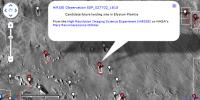
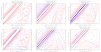
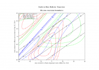
I know there are others who know the orbital mechanics far better, and I'm sure this is documented elsewhere on the web, but I was curious. So I used the tools from here to create some porkchop plots centered on the nominal departure/arrival dates for InSight. Sure enough, there is a high declination (DLA of ~45 deg) for the departure.
|
||
|
|
|
||
|
Dec 30 2013, 09:01 PM
Post
#87
|
|
|
Senior Member Group: Members Posts: 1729 Joined: 3-August 06 From: 43° 35' 53" N 1° 26' 35" E Member No.: 1004 |
the French space agency CNES has just published this cool video (mostly in French) on their seismometer for InSight
http://www.youtube.com/watch?v=k3IOKszmnyo |
|
|
|
|
May 17 2014, 05:23 PM
Post
#88
|
|
 Member Group: Members Posts: 796 Joined: 27-February 08 From: Heart of Europe Member No.: 4057 |
It looks that InSight is now planned with color camera on the arm!
Source (page 9): The 2016 InSight Mission & L/S Process -------------------- |
|
|
|
|
May 17 2014, 05:30 PM
Post
#89
|
|
|
Senior Member Group: Members Posts: 2517 Joined: 13-September 05 Member No.: 497 |
QUOTE (machi @ May 17 2014, 10:23 AM) It looks that InSight is now planned with color camera on the arm! "If this program is successful and on time" is well short of "planned". -------------------- Disclaimer: This post is based on public information only. Any opinions are my own.
|
|
|
|
|
May 17 2014, 05:41 PM
Post
#90
|
|
|
Member Group: Members Posts: 796 Joined: 27-February 08 From: Heart of Europe Member No.: 4057 |
Yes, that's more accurate but isn't "If this program is successful and on time" true for every planned mission after all?
EDIT: BTW, Thanks for correction. I wrote this news in hurry, because I was too excited about this. I hope that they will be successful with this "plan". -------------------- |
|
|
|
|
May 17 2014, 07:22 PM
Post
#91
|
|
|
Senior Member Group: Members Posts: 2517 Joined: 13-September 05 Member No.: 497 |
QUOTE (machi @ May 17 2014, 10:41 AM) isn't "If this program is successful and on time" true for every planned mission after all? True, but usually if they explicitly say this, it's code for "probably won't happen." -------------------- Disclaimer: This post is based on public information only. Any opinions are my own.
|
|
|
|
|
Jul 10 2014, 12:06 AM
Post
#92
|
|
|
Junior Member Group: Members Posts: 57 Joined: 20-January 12 From: Florida Member No.: 6317 |
InSight appears to be focussed on deep structures and the core. All the other landers look down only a few centimeters.
Is anything in planning to examine the top few tens of meters, perhaps by ground penetrating radar? I am not so interested in how Mars got the way it is, but in locating good spots for human development. For example, empty lava tubes or accessible aquifers. |
|
|
|
|
Jul 10 2014, 12:08 AM
Post
#93
|
|
|
Solar System Cartographer Group: Members Posts: 10166 Joined: 5-April 05 From: Canada Member No.: 227 |
For that you really want a mobile vehicle, not a static lander. So not on Insight, but I think GPR has been considered for future missions. One day we'll probably see it.
Phil -------------------- ... because the Solar System ain't gonna map itself.
Also to be found posting similar content on https://mastodon.social/@PhilStooke Maps for download (free PD: https://upload.wikimedia.org/wikipedia/comm...Cartography.pdf NOTE: everything created by me which I post on UMSF is considered to be in the public domain (NOT CC, public domain) |
|
|
|
|
Jul 10 2014, 04:10 AM
Post
#94
|
|
 Member Group: Members Posts: 691 Joined: 21-December 07 From: Clatskanie, Oregon Member No.: 3988 |
The ExoMars rover will have a GPR called WISDOM. Although DAN on Curiosity isn't a GPR, AFAIK it kind of acts like one, exploring the water content in hydrated minerals as well as observing it in the liquid or ice states to a depth of a few feet as the rover drives.
|
|
|
|
|
Nov 18 2014, 04:58 PM
Post
#95
|
|
|
Junior Member Group: Members Posts: 51 Joined: 31-December 10 From: Earth Member No.: 5589 |
InSight mission enters ATLO phase: http://www.jpl.nasa.gov/news/news.php?feature=4377
|
|
|
|
|
Mar 5 2015, 02:12 AM
Post
#96
|
|
 Senior Member Group: Admin Posts: 3108 Joined: 21-December 05 From: Canberra, Australia Member No.: 615 |
Landing site evaluation and spacecraft development... update
http://www.nasa.gov/jpl/insight/single-sit...r/#.VPe6TbEWK_Q |
|
|
|
|
Apr 3 2015, 09:48 AM
Post
#97
|
|
|
Senior Member Group: Members Posts: 1729 Joined: 3-August 06 From: 43° 35' 53" N 1° 26' 35" E Member No.: 1004 |
the French space agency has delivered the qualification model of its seismometer to JPL (in French) http://www.cnes.fr/web/CNES-fr/6115-commun...e.php?item=9796
|
|
|
|
|
May 27 2015, 07:06 PM
Post
#98
|
|
|
Senior Member Group: Members Posts: 1729 Joined: 3-August 06 From: 43° 35' 53" N 1° 26' 35" E Member No.: 1004 |
lots of nice hardware pictures of InSight undergoing tests
http://insight.jpl.nasa.gov/newsdisplay.cf...e_News_ID=37975 |
|
|
|
|
Jun 12 2015, 05:16 PM
Post
#99
|
|
|
Senior Member Group: Members Posts: 2086 Joined: 13-February 10 From: Ontario Member No.: 5221 |
There's been no news about the Planetary Society managing to getting that microphone on board, has there?
|
|
|
|
|
Jun 12 2015, 06:32 PM
Post
#100
|
|
|
Founder Group: Chairman Posts: 14432 Joined: 8-February 04 Member No.: 1 |
It's not onboard.
|
|
|
|
 |

|
Lo-Fi Version | Time is now: 23rd May 2024 - 11:50 PM |
|
RULES AND GUIDELINES Please read the Forum Rules and Guidelines before posting. IMAGE COPYRIGHT |
OPINIONS AND MODERATION Opinions expressed on UnmannedSpaceflight.com are those of the individual posters and do not necessarily reflect the opinions of UnmannedSpaceflight.com or The Planetary Society. The all-volunteer UnmannedSpaceflight.com moderation team is wholly independent of The Planetary Society. The Planetary Society has no influence over decisions made by the UnmannedSpaceflight.com moderators. |
SUPPORT THE FORUM Unmannedspaceflight.com is funded by the Planetary Society. Please consider supporting our work and many other projects by donating to the Society or becoming a member. |
|