Unmanned landing sites from LRO, Surveyors, Lunas, Lunakhods and impact craters from hardware impacts |

Unmanned landing sites from LRO, Surveyors, Lunas, Lunakhods and impact craters from hardware impacts |
 Sep 7 2009, 07:51 PM Sep 7 2009, 07:51 PM
Post
#1
|
|
 Senior Member  Group: Members Posts: 3419 Joined: 9-February 04 From: Minneapolis, MN, USA Member No.: 15 |
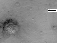
I figured it was time to begin a thread like this, especially since some of us may still be looking for the Surveyor III retro motor casing (assuming the bright dot to the north of the landing site isn't it).
We ought to be seeing some of the other Surveyors fairly soon, I would think. We know most of their locations pretty accurately. Again, I think there is a lot to be gained, both from scientific and engineering standpoints, from detailed imaging of the Surveyor VII landing site, just to mention one. And I really want to see how visible the Lunakhod tracks are as opposed to the MET and LRV tracks. So... until we begin to see images of other unmanned hardware (or the craters caused by same), we could always discuss comparisons of Surveyor III surface imagery to the new LROC images of its landing site here. I'm especially taken by how you can resolve many of the blocks in Block Crater in the LROC image, which gives you a good feel for the explosive nature of the ejecta and roughly where in the ejecta plume a given block might have come from. Might be interesting/useful to apply this information to the samples taken at that location.  -the other Doug -------------------- The trouble ain't that there is too many fools, but that the lightning ain't distributed right. -Mark Twain
|
 |
 
|
 |
|
Sep 8 2009, 04:28 PM
Post
#2
|
|
 Member Group: Members Posts: 399 Joined: 28-August 07 From: San Francisco Member No.: 3511 |
Do you know if the LROC targets will be announced in advance ?
-------------------- 'She drove until the wheels fell off...'
|
|
|
|
|
Sep 8 2009, 04:31 PM
Post
#3
|
|
|
Senior Member Group: Members Posts: 2517 Joined: 13-September 05 Member No.: 497 |
QUOTE (eoincampbell @ Sep 8 2009, 09:28 AM)  Do you know if the LROC targets will be announced in advance ? Yes. http://target.lroc.asu.edu/output/lroc/lroc_page.html If you're asking if upcoming attempts to image these targets will be announced in advance, then I don't know, but I would doubt it. -------------------- Disclaimer: This post is based on public information only. Any opinions are my own.
|
|
|
|
|
Sep 8 2009, 06:49 PM
Post
#4
|
|
|
Member Group: Members Posts: 399 Joined: 28-August 07 From: San Francisco Member No.: 3511 |
Thanks for the excellent link..
-------------------- 'She drove until the wheels fell off...'
|
|
|
|
| Guest_Zvezdichko_* |
Sep 11 2009, 09:04 AM
Post
#5
|
|
Guests |
Probably offtopic, but we can see the blast zone on Lunar Orbiter images.
http://www.moonviews.com/archives/2009/09/...ed_lunar_1.html |
|
|
|
| Guest_Zvezdichko_* |
Sep 30 2009, 09:20 PM
Post
#6
|
|
Guests |
|
|
|
|
|
Sep 30 2009, 09:43 PM
Post
#7
|
|
 Administrator Group: Admin Posts: 5172 Joined: 4-August 05 From: Pasadena, CA, USA, Earth Member No.: 454 |
Thanks! I always learn about these new releases here before my RSS reader picks them up
I've posted the photo along with Phil's version of the Surveyor 1 pan at my blog.My probably too feverish imagination is telling me you can see a light-colored blast zone around Surveyor 1 in the LROC pic. Do I need to tell my imagination to pipe down? -------------------- My website - My Patreon - @elakdawalla on Twitter - Please support unmannedspaceflight.com by donating here.
|
|
|
|
| Guest_Zvezdichko_* |
Sep 30 2009, 09:52 PM
Post
#8
|
|
Guests |
No
 This is really the white blast zone. This is really the white blast zone.I'm very disappointed that the image wasn't made public in July during the press conference. |
|
|
|
|
Sep 30 2009, 10:10 PM
Post
#9
|
|
|
Solar System Cartographer Group: Members Posts: 10186 Joined: 5-April 05 From: Canada Member No.: 227 |
Your imagination is OK, Emily. I think we see the same thing around the Surveyor 3 bounce site just uphill from its final resting place.
Phil (on the full image it's at the left edge just over half way up from the bottom) -------------------- ... because the Solar System ain't gonna map itself.
Also to be found posting similar content on https://mastodon.social/@PhilStooke Maps for download (free PD: https://upload.wikimedia.org/wikipedia/comm...Cartography.pdf NOTE: everything created by me which I post on UMSF is considered to be in the public domain (NOT CC, public domain) |
|
|
|
|
Oct 1 2009, 12:18 AM
Post
#10
|
|
 Member Group: Members Posts: 753 Joined: 23-October 04 From: Greensboro, NC USA Member No.: 103 |
I'm hesitant to say we can see blast zones for the Surveyors, when we can barely see them for the Apollo LMs, if at all. There are albedo variations in all the photos even in areas not directly under the landers. Looking at the Apollo 14 landing site, it appears that Antares is in the middle of a lighter colored blast zone. But if you check out the comparison "before" shot from Lunar Orbiter, the landing spot was already lighter than the surrounding area - what we might call a blast zone was in fact an preexisting area of higher albedo.
-------------------- Jonathan Ward
Manning the LCC at http://www.apollolaunchcontrol.com |
|
|
|
|
Oct 1 2009, 12:30 AM
Post
#11
|
|
|
Solar System Cartographer Group: Members Posts: 10186 Joined: 5-April 05 From: Canada Member No.: 227 |
That's not my interpretation of the Apollo images. I think we see clear brightening at every site where we have good images. The first Apollo 11 LROC was very bad for that, very low sun angle, but this new one shows it clearly, as did Kaguya. I don't see the pre-Apollo 14 brightening in Lunar Orbiter images either.
Phil -------------------- ... because the Solar System ain't gonna map itself.
Also to be found posting similar content on https://mastodon.social/@PhilStooke Maps for download (free PD: https://upload.wikimedia.org/wikipedia/comm...Cartography.pdf NOTE: everything created by me which I post on UMSF is considered to be in the public domain (NOT CC, public domain) |
|
|
|
|
Oct 1 2009, 01:35 AM
Post
#12
|
||
|
Member Group: Members Posts: 808 Joined: 10-October 06 From: Maynard Mass USA Member No.: 1241 |
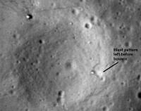
Here is the Apollo 12 / Surveyor 3 image that Phil was taking about showing the Surveyor blast pattern higher up on the crater wall.
(...please correct me if I am wrong...)
Cheers -------------------- CLA CLL
|
|
|
|
|
|
|
Oct 1 2009, 01:40 AM
Post
#13
|
|
|
Solar System Cartographer Group: Members Posts: 10186 Joined: 5-April 05 From: Canada Member No.: 227 |
Yes, that's it, and you can see it surrounds a little crater, exactly as was shown in the mission maps of the footpad imprints.
Phil -------------------- ... because the Solar System ain't gonna map itself.
Also to be found posting similar content on https://mastodon.social/@PhilStooke Maps for download (free PD: https://upload.wikimedia.org/wikipedia/comm...Cartography.pdf NOTE: everything created by me which I post on UMSF is considered to be in the public domain (NOT CC, public domain) |
|
|
|
| Guest_Zvezdichko_* |
Oct 1 2009, 07:10 AM
Post
#14
|
|
Guests |
I think I can see the blast zone of Apollo 11, but it doesn't look like a perfect circle. There are variations - remember that Armstrong manually piloted the LM.
|
|
|
|
|
Oct 1 2009, 08:37 AM
Post
#15
|
|
|
Newbie Group: Members Posts: 19 Joined: 17-June 09 Member No.: 4825 |
It looks as though the Surveyor 1 site has been imaged. The image was taken when the LRO was still in the commissioning orbit.
http://lroc.sese.asu.edu/news/?archives/11...ar-landing.html |
|
|
|
| Guest_Zvezdichko_* |
Oct 1 2009, 08:46 AM
Post
#16
|
|
Guests |
QUOTE (JRA @ Oct 1 2009, 09:37 AM) It looks as though the Surveyor 1 site has been imaged. The image was taken when the LRO was still in the commissioning orbit. http://lroc.sese.asu.edu/news/?archives/11...ar-landing.html Old http://www.unmannedspaceflight.com/index.p...st&p=147019 Anyway, good contribution |
|
|
|
|
Oct 1 2009, 10:43 AM
Post
#17
|
|
|
Newbie Group: Members Posts: 19 Joined: 17-June 09 Member No.: 4825 |
QUOTE (Zvezdichko @ Oct 1 2009, 12:46 AM) Oops, didn't realize it was posted already. My bad
|
|
|
|
|
Oct 1 2009, 11:15 AM
Post
#18
|
|
 The Poet Dude Group: Moderator Posts: 5551 Joined: 15-March 04 From: Kendal, Cumbria, UK Member No.: 60 |
Not a "bad" at all, don't worry about it JRA, it happens all the time
When I joined here I lost count of the number of times I alerted the board to something already mentioned by someone else. I prefer to think of it as "being keen to share", not "old".
-------------------- |
|
|
|
|
Oct 1 2009, 01:58 PM
Post
#19
|
||
|
Senior Member Group: Members Posts: 1074 Joined: 21-September 07 From: Québec, Canada Member No.: 3908 |
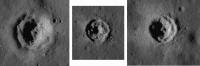
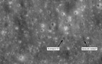
I noticed some funny-looking craters on LRO's image of the Surveyor 1 landing site. Below is a sampling.
These three craters are all at the same scale. They seem recent and are around 100 m wide or less. It looks like the unconsolidated regolith was pushed back by the blast produced by the impact, revealing the surface of the bedrock. If this interpretation is correct., these craters would make great sampling spots. No need to dig through the regolith to get to the bedrock, the work has already been done by meteorites.
Attached thumbnail(s)
|
|
|
|
|
|
|
Oct 1 2009, 03:04 PM
Post
#20
|
|
|
Member Group: Members Posts: 541 Joined: 17-November 05 From: Oklahoma Member No.: 557 |
Surveyor 1 happened to land in one of the geologically youngest spots on the moon. The regolith there is exceptionally thin, which means you will get a lot of young looking craters, and they will plow into thin soil.
|
|
|
|
|
Oct 1 2009, 03:15 PM
Post
#21
|
|
|
Solar System Cartographer Group: Members Posts: 10186 Joined: 5-April 05 From: Canada Member No.: 227 |
This type of crater was discovered in Lunar Orbiter images and recognized as a probe of the depth to bedrock. They can be used to map variations in regolith thickness. Apollo 12's backup landing site - a pinpoint landing spot in Apollo Site 5, was near a crater of this type.
Phil -------------------- ... because the Solar System ain't gonna map itself.
Also to be found posting similar content on https://mastodon.social/@PhilStooke Maps for download (free PD: https://upload.wikimedia.org/wikipedia/comm...Cartography.pdf NOTE: everything created by me which I post on UMSF is considered to be in the public domain (NOT CC, public domain) |
|
|
|
|
Oct 1 2009, 03:26 PM
Post
#22
|
|
|
Senior Member Group: Members Posts: 1074 Joined: 21-September 07 From: Québec, Canada Member No.: 3908 |
Well, so I didn't discover anything new, but anyway, these craters are cool, especially at such high definition.
|
|
|
|
|
Oct 1 2009, 09:17 PM
Post
#23
|
|
|
Member Group: Members Posts: 252 Joined: 5-May 05 From: Mississippi (USA) Member No.: 379 |
QUOTE (charborob @ Oct 1 2009, 10:26 AM) Well, so I didn't discover anything new, But I learned something new. Jack |
|
|
|
|
Oct 2 2009, 02:48 AM
Post
#24
|
||
|
Member Group: Members Posts: 808 Joined: 10-October 06 From: Maynard Mass USA Member No.: 1241 |
Here is the Surveyor 1 site
I downloaded the TIFF (!pain!) and then adjusted the dynamic levels, cropped, destriped, and a little blow up (whew!) (Dear LROC Team, please put non-annotated images up for us noodles to noodle with....like the Apollo sites!)
Cheers -------------------- CLA CLL
|
|
|
|
|
|
|
Nov 22 2009, 04:55 PM
Post
#25
|
|
|
Newbie Group: Members Posts: 2 Joined: 13-November 09 From: Brazil Member No.: 5042 |
LRO is now orbiting over Mare Crisium and the Sun is low over there.I hope it's imaging Luna 23 and 24 landing sites.
|
|
|
|
|
Mar 1 2010, 01:26 AM
Post
#26
|
|
|
Solar System Cartographer Group: Members Posts: 10186 Joined: 5-April 05 From: Canada Member No.: 227 |
LROC news from LPSC - heard from a thoroughly disreputable source (I'm only kidding, L!) - LROC has seen Luna 24 and Lunokhod 2. Results should be shown in a talk tomorrow. Maybe there will be a release soon after. Luna 24 apparently landed on a crater rim, which may have affected its sampling ability.
Phil -------------------- ... because the Solar System ain't gonna map itself.
Also to be found posting similar content on https://mastodon.social/@PhilStooke Maps for download (free PD: https://upload.wikimedia.org/wikipedia/comm...Cartography.pdf NOTE: everything created by me which I post on UMSF is considered to be in the public domain (NOT CC, public domain) |
|
|
|
|
Mar 1 2010, 01:38 AM
Post
#27
|
|
 Member Group: Members Posts: 236 Joined: 5-June 08 From: Udon Thani Member No.: 4185 |
QUOTE (Phil Stooke @ Mar 1 2010, 08:26 AM) Luna 24 apparently landed on a crater rim, which may have affected its sampling ability. That's great news Phil! Have been looking forward to those images for some time. Are they sure it's Luna 24 and not Luna 23 (which landed nearby), 23 was the one which damaged its drilling equipment on touchdown. |
|
|
|
|
Mar 1 2010, 01:45 AM
Post
#28
|
|
|
Solar System Cartographer Group: Members Posts: 10186 Joined: 5-April 05 From: Canada Member No.: 227 |
I can't tell you yet. Maybe more tomorrow.
Phil -------------------- ... because the Solar System ain't gonna map itself.
Also to be found posting similar content on https://mastodon.social/@PhilStooke Maps for download (free PD: https://upload.wikimedia.org/wikipedia/comm...Cartography.pdf NOTE: everything created by me which I post on UMSF is considered to be in the public domain (NOT CC, public domain) |
|
|
|
|
Mar 1 2010, 07:44 PM
Post
#29
|
|
|
Solar System Cartographer Group: Members Posts: 10186 Joined: 5-April 05 From: Canada Member No.: 227 |
Update. Mark Robinson showed images of three Luna landers, 20, 23 and 24. Luna 20 shows the shadow of its sample delivery arm "as if it's waving at us" according to Mark. Luna 23 is sitting on the very edge of a crater only 2 or 3 m across. No obvious sign of why it couldn't collect a sample. Luna 24 is on the rim of a c. 20 or 30 m fresh crater, which may explain an odd thing about its sample... not the amount, but the fact that it differed from the surrounding area as measured by remote sensing... it seems to consist of freshly exposed subsurface material rather than the space-weathered material all around it.
Beautiful pics - let's hope they are released very soon. Phil -------------------- ... because the Solar System ain't gonna map itself.
Also to be found posting similar content on https://mastodon.social/@PhilStooke Maps for download (free PD: https://upload.wikimedia.org/wikipedia/comm...Cartography.pdf NOTE: everything created by me which I post on UMSF is considered to be in the public domain (NOT CC, public domain) |
|
|
|
|
Mar 2 2010, 06:40 AM
Post
#30
|
|
 Senior Member Group: Members Posts: 1729 Joined: 3-August 06 From: 43° 35' 53" N 1° 26' 35" E Member No.: 1004 |
No release yet of the Luna images (too bad, where are they?!?)
in their place, this image of the Marius Hills Hole has been published on the LROC image browser http://wms.lroc.asu.edu/lroc_browse/view/M114328462R |
|
|
|
|
Mar 2 2010, 07:01 AM
Post
#31
|
|
|
Merciless Robot Group: Admin Posts: 8784 Joined: 8-December 05 From: Los Angeles Member No.: 602 |
I would imagine that someone is preparing to publish a paper on this, hence the delay in release?
-------------------- A few will take this knowledge and use this power of a dream realized as a force for change, an impetus for further discovery to make less ancient dreams real.
|
|
|
|
|
Mar 2 2010, 10:23 PM
Post
#32
|
|
|
Junior Member Group: Members Posts: 53 Joined: 15-July 09 Member No.: 4867 |
Wow, just can't wait thoses images !
There is so many things to discuss, years later, when additionnal information become available. |
|
|
|
|
Mar 8 2010, 04:42 PM
Post
#33
|
|
|
Solar System Cartographer Group: Members Posts: 10186 Joined: 5-April 05 From: Canada Member No.: 227 |
It's unfortunate that we don't yet have the LROC images of Lunas 20, 23 and 24 released... but one little extra bit of news I picked up at LPSC was that it's not absolutely certain which is which of the 23 - 24 pair. The locations wouldn't have been known well enough to tell the difference. I suspect the shapes of the shadows in low-sun images may be able to identify the one with an intact ascent stage.
Phil -------------------- ... because the Solar System ain't gonna map itself.
Also to be found posting similar content on https://mastodon.social/@PhilStooke Maps for download (free PD: https://upload.wikimedia.org/wikipedia/comm...Cartography.pdf NOTE: everything created by me which I post on UMSF is considered to be in the public domain (NOT CC, public domain) |
|
|
|
|
Mar 8 2010, 04:59 PM
Post
#34
|
|
 Senior Member Group: Members Posts: 1441 Joined: 26-July 08 Member No.: 4270 |
How close together did they land?
-------------------- -- Hungry4info (Sirius_Alpha)
|
|
|
|
|
Mar 8 2010, 07:47 PM
Post
#35
|
|
|
Solar System Cartographer Group: Members Posts: 10186 Joined: 5-April 05 From: Canada Member No.: 227 |
The usual sources always said a few hundred meters or something like that. but in reality it could be several km apart - each point would be uncertain by a few km.
Phil -------------------- ... because the Solar System ain't gonna map itself.
Also to be found posting similar content on https://mastodon.social/@PhilStooke Maps for download (free PD: https://upload.wikimedia.org/wikipedia/comm...Cartography.pdf NOTE: everything created by me which I post on UMSF is considered to be in the public domain (NOT CC, public domain) |
|
|
|
|
Mar 8 2010, 07:59 PM
Post
#36
|
|
|
Senior Member Group: Members Posts: 1441 Joined: 26-July 08 Member No.: 4270 |
Ah, wow. Was that intentional?
-------------------- -- Hungry4info (Sirius_Alpha)
|
|
|
|
|
Mar 8 2010, 08:20 PM
Post
#37
|
|
|
Senior Member Group: Members Posts: 1729 Joined: 3-August 06 From: 43° 35' 53" N 1° 26' 35" E Member No.: 1004 |
Also Luna 18 and 20 are said to have landed within a few hundred meters of each other
|
|
|
|
|
Mar 8 2010, 08:26 PM
Post
#38
|
|
|
Solar System Cartographer Group: Members Posts: 10186 Joined: 5-April 05 From: Canada Member No.: 227 |
Right, Paolo - in each case the first one failed and the second was sent to the same place, knowing it would get close but not exactly at the same point, so it would avoid any local hazard that might have affected the first one.
Luna 20 was imaged... will 18 show up in the same frame? I hope so. I'm very impatient! Phil -------------------- ... because the Solar System ain't gonna map itself.
Also to be found posting similar content on https://mastodon.social/@PhilStooke Maps for download (free PD: https://upload.wikimedia.org/wikipedia/comm...Cartography.pdf NOTE: everything created by me which I post on UMSF is considered to be in the public domain (NOT CC, public domain) |
|
|
|
|
Mar 9 2010, 05:57 PM
Post
#39
|
|
|
Member Group: Members Posts: 808 Joined: 10-October 06 From: Maynard Mass USA Member No.: 1241 |
Hey Phil,
I have my destriper and blower-upper tools at the ready for some Luna X fun. ~pdp8e -------------------- CLA CLL
|
|
|
|
|
Mar 11 2010, 01:02 AM
Post
#40
|
|
|
Solar System Cartographer Group: Members Posts: 10186 Joined: 5-April 05 From: Canada Member No.: 227 |
The LROC site has a place to ask questions. I asked for these images, sneakily hiding my identity by only describing myself as Phil - hmm, I hope they're not reading this...
Phil -------------------- ... because the Solar System ain't gonna map itself.
Also to be found posting similar content on https://mastodon.social/@PhilStooke Maps for download (free PD: https://upload.wikimedia.org/wikipedia/comm...Cartography.pdf NOTE: everything created by me which I post on UMSF is considered to be in the public domain (NOT CC, public domain) |
|
|
|
|
Mar 11 2010, 09:37 AM
Post
#41
|
|
|
Member Group: Members Posts: 212 Joined: 19-July 05 Member No.: 442 |
QUOTE (Phil Stooke @ Mar 2 2010, 03:44 AM) Update. Mark Robinson showed images of three Luna landers, 20, 23 and 24. Luna 20 shows the shadow of its sample delivery arm "as if it's waving at us" according to Mark. Luna 23 is sitting on the very edge of a crater only 2 or 3 m across. No obvious sign of why it couldn't collect a sample. Pure speculation on my part here, but is it not possible that the drill is pointing into the crater and thus the drill head could not be extended far enough to reach the ground inside the crater to take a sample. It might also explain why the Russians operated the probe for two or three days on the surface after landing, without a camera they would have been unable to see the terrain around the spacecraft and might have tried to diagnose the problem by running the drill at different times of the lunar day. |
|
|
|
|
Mar 11 2010, 02:43 PM
Post
#42
|
|
|
Solar System Cartographer Group: Members Posts: 10186 Joined: 5-April 05 From: Canada Member No.: 227 |
They said the drill was damaged - maybe struck a rock as it landed? But that we may not be able to tell from LROC images. I think a GLXP-type rover may have to examine the site to answer that!
Phil -------------------- ... because the Solar System ain't gonna map itself.
Also to be found posting similar content on https://mastodon.social/@PhilStooke Maps for download (free PD: https://upload.wikimedia.org/wikipedia/comm...Cartography.pdf NOTE: everything created by me which I post on UMSF is considered to be in the public domain (NOT CC, public domain) |
|
|
|
|
Mar 11 2010, 08:47 PM
Post
#43
|
|
|
Solar System Cartographer Group: Members Posts: 10186 Joined: 5-April 05 From: Canada Member No.: 227 |
Now they're teasing us (or just me) - today's release is about 30 km from the Luna 24 position.
Phil -------------------- ... because the Solar System ain't gonna map itself.
Also to be found posting similar content on https://mastodon.social/@PhilStooke Maps for download (free PD: https://upload.wikimedia.org/wikipedia/comm...Cartography.pdf NOTE: everything created by me which I post on UMSF is considered to be in the public domain (NOT CC, public domain) |
|
|
|
|
Mar 11 2010, 11:01 PM
Post
#44
|
|
|
Member Group: Members Posts: 212 Joined: 19-July 05 Member No.: 442 |
QUOTE (Phil Stooke @ Mar 11 2010, 10:43 PM) They said the drill was damaged - maybe struck a rock as it landed? But that we may not be able to tell from LROC images. I think a GLXP-type rover may have to examine the site to answer that! Phil For a definitive answer probably, but if the drill head was not making ground contact the following scenarios are likely: 1. Free rotation, which could damage the motors. 2. Someone assumes they've bent the guide rails on the drill. It would be wonderful to know if they left the drill at full extension or not when they abandoned the probe. |
|
|
|
|
Mar 16 2010, 08:55 AM
Post
#45
|
|
|
Member Group: Members Posts: 236 Joined: 5-June 08 From: Udon Thani Member No.: 4185 |
The longer I look at these new images, the more I get a feeling that Luna 23 is standing at some quite extreme angle, not yet completely on its side but certainly tilted a lot (maybe due to the fact that it landed on a crater rim, possibly with one or two legs inside the crater?).
Shadows and reflections just don't seem to match up with what I feel you should see if it was standing upright. Maybe this large tilt was preventing the drill from operating, or the ascent stage from taking off? I'm searching everywhere in the vicinity of Luna 20 to find any trace of number 18, but as yet nothing. We know it failed at the very final stage of landing, more or less on touch-down, so it should have landed more or less intact although it might be laying on its side.. |
|
|
|
|
Mar 16 2010, 12:44 PM
Post
#46
|
|
 Member Group: Members Posts: 568 Joined: 20-April 05 From: Silesia Member No.: 299 |
-------------------- Free software for planetary science (including Cassini Image Viewer).
http://members.tripod.com/petermasek/marinerall.html |
|
|
|
|
Mar 16 2010, 01:45 PM
Post
#47
|
||
|
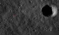
Solar System Cartographer Group: Members Posts: 10186 Joined: 5-April 05 From: Canada Member No.: 227 |
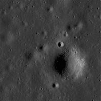
Moving into this thread from the other one... here's the full resolution data of Lunokhod 2, end of track, with details of its last maneuvers and a dark spot marking the rover. Nice detail in the tracks themselves. Image number is in the file name if you save it.
Phil
-------------------- ... because the Solar System ain't gonna map itself.
Also to be found posting similar content on https://mastodon.social/@PhilStooke Maps for download (free PD: https://upload.wikimedia.org/wikipedia/comm...Cartography.pdf NOTE: everything created by me which I post on UMSF is considered to be in the public domain (NOT CC, public domain) |
|
|
|
|
|
|
Mar 16 2010, 02:44 PM
Post
#48
|
||
 Junior Member Group: Members Posts: 55 Joined: 1-May 06 From: Cincinnati, Ohio Member No.: 758 |
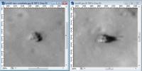
Much clearer in the original higher - resolution shot, Phil. Here is what it looks like from the photo Emily L. posted on the Planetary Society blog. This is a negative and clipped image with the contrast adjusted slightly in the old MS Photo Editor - and it is still visible!
Rob
Attached thumbnail(s)
|
|
|
|
|
|
|
Mar 16 2010, 04:07 PM
Post
#49
|
|
|
Administrator Group: Admin Posts: 5172 Joined: 4-August 05 From: Pasadena, CA, USA, Earth Member No.: 454 |
QUOTE (Phil Stooke @ Mar 16 2010, 06:45 AM) Moving into this thread from the other one... here's the full resolution data of Lunokhod 2, end of track, with details of its last maneuvers and a dark spot marking the rover. Nice detail in the tracks themselves. Phil, the gray levels in the plains look posterized -- is that how the original data looks or did the histogram get squished during processing somewhere? Marvelous to be able to resolve the rover tracks like this!! -------------------- My website - My Patreon - @elakdawalla on Twitter - Please support unmannedspaceflight.com by donating here.
|
|
|
|
|
Mar 16 2010, 04:53 PM
Post
#50
|
|
|
Solar System Cartographer Group: Members Posts: 10186 Joined: 5-April 05 From: Canada Member No.: 227 |
The original is rather low contrast. I'm not doing any calibration etc. - the fully processed versions might be better than this.
Phil -------------------- ... because the Solar System ain't gonna map itself.
Also to be found posting similar content on https://mastodon.social/@PhilStooke Maps for download (free PD: https://upload.wikimedia.org/wikipedia/comm...Cartography.pdf NOTE: everything created by me which I post on UMSF is considered to be in the public domain (NOT CC, public domain) |
|
|
|
|
Mar 17 2010, 01:02 PM
Post
#51
|
||
|
Solar System Cartographer Group: Members Posts: 10186 Joined: 5-April 05 From: Canada Member No.: 227 |
This is an image from the commissioning orbit. Later images from mapping orbit may be better. Image number will follow in a locator image.
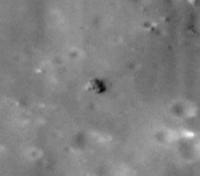
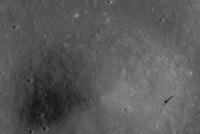
I think this is Surveyor 5. Can't be certain yet but several details around it seem to work. Phil
-------------------- ... because the Solar System ain't gonna map itself.
Also to be found posting similar content on https://mastodon.social/@PhilStooke Maps for download (free PD: https://upload.wikimedia.org/wikipedia/comm...Cartography.pdf NOTE: everything created by me which I post on UMSF is considered to be in the public domain (NOT CC, public domain) |
|
|
|
|
|
|
Mar 17 2010, 08:21 PM
Post
#52
|
|
|
Merciless Robot Group: Admin Posts: 8784 Joined: 8-December 05 From: Los Angeles Member No.: 602 |
<waiting anxiously for confirmation, hoping Phil pulls a two-fer for the week...>
-------------------- A few will take this knowledge and use this power of a dream realized as a force for change, an impetus for further discovery to make less ancient dreams real.
|
|
|
|
|
Mar 17 2010, 09:23 PM
Post
#53
|
|
|
Solar System Cartographer Group: Members Posts: 10186 Joined: 5-April 05 From: Canada Member No.: 227 |
More of a one-fer, I'm afraid. Now I'm afraid to open my mouth.
However, others add more info... Check out this link at the Vernadsky Institute: http://www.planetology.ru/panoramas/lunokh...anguage=english ... where Sasha Basilevsky has posted the discovery of Lunokhod 1 and Luna 17. That's a much bigger deal than Lunokhod 2 (plus it happens to be correct). I have the full image and I'll post details soon. Tracks are barely visible, unlike those of Lunokhod 2, but that may vary with lighting. However I can see tracks in some cases, especially near the biggest crater. I would not have found this by my preferred method, comparing the old Soviet maps with this, because my main feature, the biggest crater, isn't visible in this view. It must be very subdued and only visible under very low lighting. Phil -------------------- ... because the Solar System ain't gonna map itself.
Also to be found posting similar content on https://mastodon.social/@PhilStooke Maps for download (free PD: https://upload.wikimedia.org/wikipedia/comm...Cartography.pdf NOTE: everything created by me which I post on UMSF is considered to be in the public domain (NOT CC, public domain) |
|
|
|
|
Mar 18 2010, 01:20 AM
Post
#54
|
|
|
Newbie Group: Members Posts: 4 Joined: 12-November 09 Member No.: 5040 |
Okay, I've taken a look at NASA site: http://lroc.sese.asu.edu/news/index.php?/a...nar_Rovers.html
There are some errors on page. First of all the two images of Lunokhod 1 and 2 is actually same image just differently processed. What is shows is Lunokhod 2, which I verified using old soviet map of the trail it took on the surface available here - http://astro4u.net/yabbse/index.php/topic,....html#msg241262 The green rectangle I placed there is - more or less - the data gathered by LRO. |
|
|
|
|
Mar 18 2010, 01:26 AM
Post
#55
|
|
|
Member Group: Members Posts: 236 Joined: 5-June 08 From: Udon Thani Member No.: 4185 |
QUOTE (Phil Stooke @ Mar 18 2010, 05:23 AM) . where Sasha Basilevsky has posted the discovery of Lunokhod 1 and Luna 17. That's great news Phil! On the Soviet side of things, that leaves Luna 16 and Luna 18, both of whom I expect will be discovered in the near future. And offcourse the big price, finding Luna 9 and 13, which will be very very hard given the small size of the landers and the large uncertainty in their positions, but who knows... I still have the impression that Luna 23 is standing at a very large tilt, possibly with one of two of its legs in the crater or on top of some boulder. Given the size of that lander (which includes the ascent stage) the length of the shadow doesn't seem to add up and sun reflections are very different from Luna 24 which is seen under the same sun angle. An extreme tilt might have disabled the drill and/or the firing of the ascent stage. |
|
|
|
|
Mar 18 2010, 09:27 AM
Post
#56
|
|
|
Senior Member Group: Members Posts: 2998 Joined: 30-October 04 Member No.: 105 |
The Quotable Phil is quoted in Science Daily:
QUOTE Russian Lunar Rover Found: 37-Year-Old Space Mystery Solved A researcher from The University of Western Ontario has helped solve a 37-year old space mystery using lunar images released March 15 by NASA and maps from his own atlas of the moon... http://www.sciencedaily.com/releases/2010/...00316164950.htm --Bill -------------------- |
|
|
|
|
Mar 18 2010, 12:42 PM
Post
#57
|
|
 Senior Member Group: Members Posts: 2173 Joined: 28-December 04 From: Florida, USA Member No.: 132 |
QUOTE (Bill Harris @ Mar 18 2010, 04:27 AM) The Quotable Phil is quoted in Science Daily... I wonder if Science Daily will correct their article to indicate the true position of the rover, which readers of this site learned from Phil yesterday.
|
|
|
|
|
Mar 19 2010, 02:22 PM
Post
#58
|
|
|
Solar System Cartographer Group: Members Posts: 10186 Joined: 5-April 05 From: Canada Member No.: 227 |
I've been trying to get the word out about this, but generally there is less interest in such corrections. You know how it is - the story about a celebrity scandal is on page 1, the correction is on the back page.
The think that really concerned me was how the story turned into a 37-year-old mystery about a lost rover. That was all created by people trying to write eyecatching headlines. But it becomes very embarrassing. I found what I thought was the Lunokhod in an image - I knew as any of us would have that it was in that specific image, from the coordinates. I saw the dark track and the dark spot but didn't notice the fainter track leading up to the bright spot - I had already cropped the image around the dark spot. But it was about a location in an image. It gets turned into finding a location on the moon, as if it was lost. So now Russians working on this are saying - 'it wasn't lost, we knew where it was all along'. Quite rightly. And people are asking me 'how do you lose a rover on the moon?' - but of course that didn't happen. Anyway I did a story with AOL yesterday which may help. Phil -------------------- ... because the Solar System ain't gonna map itself.
Also to be found posting similar content on https://mastodon.social/@PhilStooke Maps for download (free PD: https://upload.wikimedia.org/wikipedia/comm...Cartography.pdf NOTE: everything created by me which I post on UMSF is considered to be in the public domain (NOT CC, public domain) |
|
|
|
|
Mar 19 2010, 03:45 PM
Post
#59
|
|
|
Administrator Group: Admin Posts: 5172 Joined: 4-August 05 From: Pasadena, CA, USA, Earth Member No.: 454 |
The story is a bit goofy but at least they have the corrected location:
http://www.aolnews.com/science/article/nas...-rover/19405554 -------------------- My website - My Patreon - @elakdawalla on Twitter - Please support unmannedspaceflight.com by donating here.
|
|
|
|
|
Mar 19 2010, 04:39 PM
Post
#60
|
|
|
Senior Member Group: Members Posts: 2998 Joined: 30-October 04 Member No.: 105 |
Goofy, silly and sensational headlining, but at least word is getting out on the work that LRO (et al) is doing. Take the general media reports with a passel of salt and we'll be OK. The AOL article was tolerable until it lapsed into the Richard Garriot story.
I noticed that the Soviet map matched some craters well enough, some it was off, some way, way off. I'll be interesting when Phil (or someone) is able to rubber-sheet the map to the images. --Bill -------------------- |
|
|
|
|
Mar 19 2010, 05:16 PM
Post
#61
|
|
|
Merciless Robot Group: Admin Posts: 8784 Joined: 8-December 05 From: Los Angeles Member No.: 602 |
It's amazing to watch how this story unfolds in the mass media. Phil, you're a long way from Hollywood, so just to save you the trip this weekend I'll drive up there, assume your identity & have you on tabloid covers & TMZ by Sunday morning. You're welcome.
On a completely different note, have any of the booster impact and/or Ranger sites been imaged at high resolution yet? Assume that the S-IVB hits might be the easiest of these to spot. EDIT: And right after posting, I see you've found the Apollo 14 LM impact already! You're a machine, Phil; go, man, go!!! -------------------- A few will take this knowledge and use this power of a dream realized as a force for change, an impetus for further discovery to make less ancient dreams real.
|
|
|
|
|
Mar 19 2010, 06:10 PM
Post
#62
|
|
|
Junior Member Group: Members Posts: 94 Joined: 15-October 09 Member No.: 4979 |
I've been searching for Ranger 9 impact scar, but my blasted internet connection at work keeps timing out...
|
|
|
|
|
Mar 19 2010, 07:21 PM
Post
#63
|
|
|
Solar System Cartographer Group: Members Posts: 10186 Joined: 5-April 05 From: Canada Member No.: 227 |
Ranger 9 looks to be outside the coverage we have so far - looks like the best images are just to the east of it. I posted Apollo 14's LM ascent stage (or shall we say a candidate for it) in the other thread.
Phil -------------------- ... because the Solar System ain't gonna map itself.
Also to be found posting similar content on https://mastodon.social/@PhilStooke Maps for download (free PD: https://upload.wikimedia.org/wikipedia/comm...Cartography.pdf NOTE: everything created by me which I post on UMSF is considered to be in the public domain (NOT CC, public domain) |
|
|
|
|
Mar 20 2010, 02:49 PM
Post
#64
|
|
|
Junior Member Group: Members Posts: 68 Joined: 10-September 05 Member No.: 493 |
Luna-21 found
http://lroc.sese.asu.edu/news/?archives/20...-21-Lander.html  Who did not try to find a Luna-16? -0.68 56.3 http://wms.lroc.asu.edu/lroc/view_lroc/LRO....0/M106511834LE -------------------- |
|
|
|
|
Mar 21 2010, 08:18 PM
Post
#65
|
|
 Member Group: Members Posts: 557 Joined: 1-May 06 From: Scotland (Ecosse, Escocia) Member No.: 759 |
No-one appears to have turned up Luna 16 to date, so Im wondering if there is something about this one (such as poorer LROC imagery) which is inhibiting the search? I see bright objects in the correct area, some with apparent shadows going the correct way, but none anything like as sharp as the Luna 17, 20, 23 etc images.
|
|
|
|
|
Mar 22 2010, 02:09 AM
Post
#66
|
|
|
Member Group: Members Posts: 236 Joined: 5-June 08 From: Udon Thani Member No.: 4185 |
LROC side has images of Surveyor 6 and Surveyor 5.
Luna 16 and Luna 18 still appear to be missing although they should be somewhere in the imagery. Am I correct that the Luna 9-13 area has not yet been imaged/released by LRO? |
|
|
|
|
Mar 22 2010, 05:24 PM
Post
#67
|
|
|
Junior Member Group: Members Posts: 68 Joined: 10-September 05 Member No.: 493 |
QUOTE (Geert @ Mar 22 2010, 07:39 AM) Am I correct that the Luna 9-13 area has not yet been imaged/released by LRO? No. It remains to find the 4 stations made a soft landing on the moon - Luna-9, 13, 16, Surveyor-7. -------------------- |
|
|
|
|
Mar 22 2010, 06:40 PM
Post
#68
|
|
|
Senior Member Group: Members Posts: 1441 Joined: 26-July 08 Member No.: 4270 |
What about Ranger impacts? Or the Surveyor 2 crash site? Any plans to look for these?
-------------------- -- Hungry4info (Sirius_Alpha)
|
|
|
|
|
Mar 22 2010, 07:15 PM
Post
#69
|
|
|
Solar System Cartographer Group: Members Posts: 10186 Joined: 5-April 05 From: Canada Member No.: 227 |
Everything will be looked for! The list of targets - thousands of them including all anthropogenic sites - has been public for months. It's just a matter of actually getting the right images. and finding the objects.
Phil -------------------- ... because the Solar System ain't gonna map itself.
Also to be found posting similar content on https://mastodon.social/@PhilStooke Maps for download (free PD: https://upload.wikimedia.org/wikipedia/comm...Cartography.pdf NOTE: everything created by me which I post on UMSF is considered to be in the public domain (NOT CC, public domain) |
|
|
|
|
Mar 22 2010, 07:56 PM
Post
#70
|
|
|
Junior Member Group: Members Posts: 94 Joined: 15-October 09 Member No.: 4979 |
QUOTE (Phil Stooke @ Mar 22 2010, 03:15 PM) Everything will be looked for! The list of targets - thousands of them including all anthropogenic sites - has been public for months. It's just a matter of actually getting the right images. and finding the objects. Phil Mostly the right lighting conditions. You can't find anything in the images with direct overhead solar lighting... |
|
|
|
|
Mar 23 2010, 10:05 AM
Post
#71
|
|
|
Junior Member Group: Members Posts: 68 Joined: 10-September 05 Member No.: 493 |
 QUOTE Caption: Bang! On April 14th 1970, the Apollo 13 Saturn IVB upper stage impacted the Moon North of Mare Cognitum, at -2.55° latitude, -27.88° East longitude. The impact crater, which is roughly 30 meters in diameter, is clearly visible in LROC NAC image M109420042LE [NASA/GSFC/Arizona State University] http://lroc.sese.asu.edu/news/?archives/20...ic-network.html -------------------- |
|
|
|
|
Mar 23 2010, 01:54 PM
Post
#72
|
|
 Senior Member Group: Admin Posts: 4763 Joined: 15-March 05 From: Glendale, AZ Member No.: 197 |
That has got to be the best man-made impact site we've seen yet.
-------------------- If Occam had heard my theory, things would be very different now.
|
|
|
|
|
Mar 23 2010, 11:28 PM
Post
#73
|
|
|
Senior Member Group: Members Posts: 2090 Joined: 13-February 10 From: Ontario Member No.: 5221 |
Now that's what I'm talking about! Good old fashioned explosions!
|
|
|
|
|
Mar 25 2010, 12:55 PM
Post
#74
|
||
|
Member Group: Members Posts: 236 Joined: 5-June 08 From: Udon Thani Member No.: 4185 |
Most probably it's just one of the many rocks in the area, but size and shadow at least seem to comply with the other Luna sample return missions, so this might be a candidate for Luna 18? Object is somewhat to the northeast of the Luna 20 lander on LRO image M119482862R. Lots and lots of (big) rocks all over the area, but most of them are either too big, too small, or too rounded to be a lander, assuming at least that Luna 18 more or less landed intact (contact seems to have been lost at a altitude of less then 100 mtr). |
|
|
|
|
|
|
Mar 25 2010, 01:31 PM
Post
#75
|
|
|
Member Group: Members Posts: 557 Joined: 1-May 06 From: Scotland (Ecosse, Escocia) Member No.: 759 |
Looks more like a boulder to me, with its uniform relfectivity and boulder-shaped shadow, rather than a multi-faceted tall, thin metallic object. But as always, it's easy to be wrong in this game...
|
|
|
|
|
Mar 25 2010, 04:54 PM
Post
#76
|
|
|
Junior Member Group: Members Posts: 68 Joined: 10-September 05 Member No.: 493 |
-------------------- |
|
|
|
|
Mar 26 2010, 05:30 AM
Post
#77
|
|
|
Merciless Robot Group: Admin Posts: 8784 Joined: 8-December 05 From: Los Angeles Member No.: 602 |
That's one of the clearest shots yet.
-------------------- A few will take this knowledge and use this power of a dream realized as a force for change, an impetus for further discovery to make less ancient dreams real.
|
|
|
|
|
Apr 10 2010, 10:23 AM
Post
#78
|
||
|
Member Group: Members Posts: 236 Joined: 5-June 08 From: Udon Thani Member No.: 4185 |
The list at the LROC site states a preliminary position for Luna 18 at 3.760 N 56.655 E on image M119482862R pixel coordinates 3189 X 28221.
Given that the pixel coordinates relate to the raw image (flipped), this translates to coordinates 1875 X 28221 on the image as published, leading us to below position.
Conform the same logic, Luna 20 can indeed be found on the same image at pixel coordinates 4086 X 29618, so hopefully my mathematics are correct. If this is indeed Luna 18, the craft seems to have landed on the edge of a crater, but how much damage it sustained is impossible to tell. Hopefully we get clearer images later. |
|
|
|
|
|
|
Apr 10 2010, 01:53 PM
Post
#79
|
|
|
Solar System Cartographer Group: Members Posts: 10186 Joined: 5-April 05 From: Canada Member No.: 227 |
I didn't know we had access to that image yet.
Phil -------------------- ... because the Solar System ain't gonna map itself.
Also to be found posting similar content on https://mastodon.social/@PhilStooke Maps for download (free PD: https://upload.wikimedia.org/wikipedia/comm...Cartography.pdf NOTE: everything created by me which I post on UMSF is considered to be in the public domain (NOT CC, public domain) |
|
|
|
|
Apr 10 2010, 03:11 PM
Post
#80
|
|
|
Member Group: Members Posts: 236 Joined: 5-June 08 From: Udon Thani Member No.: 4185 |
QUOTE (Phil Stooke @ Apr 10 2010, 08:53 PM) I didn't know we had access to that image yet. The site doesn't give you direct access to that image, but when I ran a search for it in the library the raw TIFF nevertheless showed up and could be downloaded. http://wms.lroc.asu.edu/lroc_browse/view/M119482862R Tried the same to get Surveyor 7 but that image as yet seems unaccessable. |
|
|
|
|
Apr 10 2010, 05:35 PM
Post
#81
|
||
|
Solar System Cartographer Group: Members Posts: 10186 Joined: 5-April 05 From: Canada Member No.: 227 |
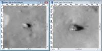
Thanks for the tip!
I'm learning a lot here. Locating both those landers on that image, I find that they are further north than I had expected. Also, that raw image is south-up. If it's rotated 180 degrees it is right-reading - no further flip needed. When I compare the two landers - I mean the candidate Luna 18 lander as it's not confirmed yet - I find the 'Luna 18' is quite a bit smaller than Luna 20:
Maybe it's not the right object, but large rocks are very rare in this region. Phil -------------------- ... because the Solar System ain't gonna map itself.
Also to be found posting similar content on https://mastodon.social/@PhilStooke Maps for download (free PD: https://upload.wikimedia.org/wikipedia/comm...Cartography.pdf NOTE: everything created by me which I post on UMSF is considered to be in the public domain (NOT CC, public domain) |
|
|
|
|
|
|
Apr 10 2010, 05:45 PM
Post
#82
|
|||
|
Senior Member Group: Admin Posts: 4763 Joined: 15-March 05 From: Glendale, AZ Member No.: 197 |
How far apart are they in the image Phil, is it possible that we are looking at a perspective issue here? No doubt that the Luna 20 candidate is a man made object, you can even discern the shadow of narrow cross-section antennas or whatever they are protruding from the top.
EDIT: Also, is it possible the impact caused it to embed in the regolith somewhat or some of the protruding devices to separate, giving it that smaller appearance?
Attached thumbnail(s)
-------------------- If Occam had heard my theory, things would be very different now.
|
||
|
|
|
||
|
Apr 10 2010, 05:53 PM
Post
#83
|
|||
|
Solar System Cartographer Group: Members Posts: 10186 Joined: 5-April 05 From: Canada Member No.: 227 |
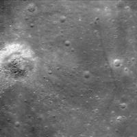
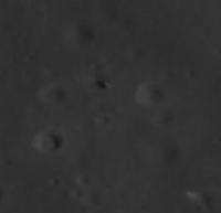
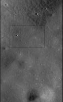
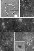
This is a locator image for Luna 20 and the Luna 18 candidate:
The black box (approx. 1500 m wide) has Luna 20 in the upper left corner and the Luna 18 candidate in the lower right corner. But while searching through the image I found this object:
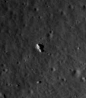
It's inside that large crater at the bottom of the locator image. It appears to be exactly the same size and form as Luna 20. Phil -------------------- ... because the Solar System ain't gonna map itself.
Also to be found posting similar content on https://mastodon.social/@PhilStooke Maps for download (free PD: https://upload.wikimedia.org/wikipedia/comm...Cartography.pdf NOTE: everything created by me which I post on UMSF is considered to be in the public domain (NOT CC, public domain) |
||
|
|
|
||
|
Apr 10 2010, 06:05 PM
Post
#84
|
|
|
Senior Member Group: Admin Posts: 4763 Joined: 15-March 05 From: Glendale, AZ Member No.: 197 |
Wow...good eye
-------------------- If Occam had heard my theory, things would be very different now.
|
|
|
|
|
Apr 10 2010, 06:15 PM
Post
#85
|
|
|
Solar System Cartographer Group: Members Posts: 10186 Joined: 5-April 05 From: Canada Member No.: 227 |
The large crater in that locator image is 4 km north of the expected landing site.
Phil -------------------- ... because the Solar System ain't gonna map itself.
Also to be found posting similar content on https://mastodon.social/@PhilStooke Maps for download (free PD: https://upload.wikimedia.org/wikipedia/comm...Cartography.pdf NOTE: everything created by me which I post on UMSF is considered to be in the public domain (NOT CC, public domain) |
|
|
|
|
Apr 10 2010, 06:47 PM
Post
#86
|
||
|
Solar System Cartographer Group: Members Posts: 10186 Joined: 5-April 05 From: Canada Member No.: 227 |
Here's the new comparison image. (PS I really ought to be doing some work around the house... but who can leave this stuff alone?)
Phil -------------------- ... because the Solar System ain't gonna map itself.
Also to be found posting similar content on https://mastodon.social/@PhilStooke Maps for download (free PD: https://upload.wikimedia.org/wikipedia/comm...Cartography.pdf NOTE: everything created by me which I post on UMSF is considered to be in the public domain (NOT CC, public domain) |
|
|
|
|
|
|
Apr 10 2010, 06:54 PM
Post
#87
|
|
|
Founder Group: Chairman Posts: 14433 Joined: 8-February 04 Member No.: 1 |
I can almost convince myself that the crash landing has caused the ascent stage to fall over to the north.
|
|
|
|
|
Apr 10 2010, 08:00 PM
Post
#88
|
|
|
Solar System Cartographer Group: Members Posts: 10186 Joined: 5-April 05 From: Canada Member No.: 227 |
If this is Luna 18 it obviously landed - rather than crashed - but presumably landed hard enough to do some serious damage to the spacecraft, especially its communication system.
The difference in shadow lengths between the two objects is related to local slopes - Luna 18 (my candidate for it anyway) is on a crater wall sloping toward the sun. Phil -------------------- ... because the Solar System ain't gonna map itself.
Also to be found posting similar content on https://mastodon.social/@PhilStooke Maps for download (free PD: https://upload.wikimedia.org/wikipedia/comm...Cartography.pdf NOTE: everything created by me which I post on UMSF is considered to be in the public domain (NOT CC, public domain) |
|
|
|
|
Apr 11 2010, 12:15 AM
Post
#89
|
|
|
Member Group: Members Posts: 236 Joined: 5-June 08 From: Udon Thani Member No.: 4185 |
QUOTE (Phil Stooke @ Apr 11 2010, 03:00 AM) If this is Luna 18 it obviously landed - rather than crashed - but presumably landed hard enough to do some serious damage to the spacecraft, especially its communication system. Impossible to tell whether your candidate or the 'official' candidate is Luna 18, we have to wait until they release some new images, preferably with a low sun angle. We should keep in mind that Luna 18 (like Luna 23) should have its ascent stage still on top (contrary to Luna 16/20), so it should be a lot higher (unless the thing has toppled over on landing and is lying on its side as might be the case with the official candidate). Probably Luna 18 can best be compared with Luna 23, but then we need two images with similar sun-angle. |
|
|
|
|
Apr 11 2010, 12:28 AM
Post
#90
|
|
|
Founder Group: Chairman Posts: 14433 Joined: 8-February 04 Member No.: 1 |
QUOTE (Geert @ Apr 11 2010, 01:15 AM) Impossible to tell whether your candidate or the 'official' candidate is Luna 18, I'd say it's a very very very very very very very very very very very good candidate. If it's NOT Luna 18, then someone else landed a replica Luna spacecraft at some point. |
|
|
|
|
Apr 11 2010, 07:39 AM
Post
#91
|
|
|
Member Group: Members Posts: 557 Joined: 1-May 06 From: Scotland (Ecosse, Escocia) Member No.: 759 |
I agree that Phil's object is Luna 18. Geert's object looks like a rock which is a different shape and substantially smaller than a Luna. Geert, thnanks also for explaining how there are more images available than the system seems to show, which also explains how no-one (to my knowledge) has been able to find Luna 16 in a big context image, although the craft itself has been excised and posted by the LROC people.
If south is to the bottom, the ascent stage might actually have toppled over to the SE, and there is a curious extra shadow on the NE side of the image.. a rock or an arm or antenna of the spacecraft? Better defintion image awaited with interest. |
|
|
|
|
Apr 11 2010, 09:43 AM
Post
#92
|
||
|
Member Group: Members Posts: 236 Joined: 5-June 08 From: Udon Thani Member No.: 4185 |
QUOTE (kenny @ Apr 11 2010, 02:39 PM) I agree that Phil's object is Luna 18. Geert's object looks like a rock which is a different shape and substantially smaller than a Luna. If south is to the bottom, the ascent stage might actually have toppled over to the SE, and there is a curious extra shadow on the NE side of the image.. a rock or an arm or antenna of the spacecraft? Better defintion image awaited with interest. The object I mentioned before was at the coordinates the LROC site gave for Luna 18, so it's no 'Geert's object'  I agree that the object Phil shows much better conforms to size and shape of a Luna sample return craft, so I think he has indeed a much better candidate. I tried to find the object Phil mentions in other images of the area, problem is making sure that you have indeed the same thing, but maybe I succeeded in M104147428LE, if I'm correct than the same crater Phil mentions is in this image almost at the bottom of the image.
Might this be the same object Phil has found? It certainly looks 'artificial' and indeed as if the ascent stage has broken off, there still seem to be some shadows of antenna.. EDIT: From the latest localizer image Phil posted, it's clear I had the correct crater, but the wrong stone/object ! Still trying to find the correct object in the other images of the area. I'm trying to get the same thing in other images as well, and trying to work out convincingly that we are indeed talking about the same thing, it's hard to puzzle out how pixel-coordinates from one image map into the other, so I might very well be wrong! If I can find the time I'll try to work out a better method of making sure we are talking about the same thing.. |
|
|
|
|
|
|
Apr 11 2010, 10:17 AM
Post
#93
|
|
|
Senior Member Group: Members Posts: 1441 Joined: 26-July 08 Member No.: 4270 |
I'm not convinced. Looking at the shadow gives you a rough idea of what the shape of the object is along the line of sight. It looks rather bumpy, but then again I don't know if the shadow of the object falling on that (what appears to be) rock is the cause of this.
-------------------- -- Hungry4info (Sirius_Alpha)
|
|
|
|
|
Apr 11 2010, 12:15 PM
Post
#94
|
||
|
Solar System Cartographer Group: Members Posts: 10186 Joined: 5-April 05 From: Canada Member No.: 227 |
Here's a finder image for Luna 16 - I just figured it out yesterday. I'm preparing guides like this to all the previously unlocated objects. Phil -------------------- ... because the Solar System ain't gonna map itself.
Also to be found posting similar content on https://mastodon.social/@PhilStooke Maps for download (free PD: https://upload.wikimedia.org/wikipedia/comm...Cartography.pdf NOTE: everything created by me which I post on UMSF is considered to be in the public domain (NOT CC, public domain) |
|
|
|
|
|
|
Apr 11 2010, 01:14 PM
Post
#95
|
|||
|
Solar System Cartographer Group: Members Posts: 10186 Joined: 5-April 05 From: Canada Member No.: 227 |
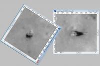
This is where my Luna 18 candidate is:
and here is the same thing at high sun. It doesn't look so convincing in this image.
Phil -------------------- ... because the Solar System ain't gonna map itself.
Also to be found posting similar content on https://mastodon.social/@PhilStooke Maps for download (free PD: https://upload.wikimedia.org/wikipedia/comm...Cartography.pdf NOTE: everything created by me which I post on UMSF is considered to be in the public domain (NOT CC, public domain) |
||
|
|
|
||
|
Apr 11 2010, 03:08 PM
Post
#96
|
|
|
Member Group: Members Posts: 236 Joined: 5-June 08 From: Udon Thani Member No.: 4185 |
QUOTE (Phil Stooke @ Apr 11 2010, 08:14 PM) and here is the same thing at high sun. It doesn't look so convincing in this image. Judging from your latest image, I clearly found the wrong object although possibly in the correct crater. Based on the lat/lon data and the image data, both the "official" luna 18 candidate as probably your candidate, should also be visible in image M104147428LE which seems to have a more favorable sun angle, however as yet I didn't manage to find either. Don't know why they don't include this image on the list at the preliminary Luna 18 position, while it seems to cover the area, maybe they simply haven't managed either to find the object in this image? |
|
|
|
|
Apr 11 2010, 08:01 PM
Post
#97
|
|
|
Member Group: Members Posts: 557 Joined: 1-May 06 From: Scotland (Ecosse, Escocia) Member No.: 759 |
QUOTE (Phil Stooke @ Apr 10 2010, 07:47 PM) Here's the new comparison image. (PS I really ought to be doing some work around the house... but who can leave this stuff alone?) Housework indeed ... and bang goes the gardening. I'm looking at Phil's second set of 2 comparison images. Now assuming the landing orientations of the 2 craft are roughly the same, I'm seeing in the case of Luna 18 an extra "lump" at the South East (bottom right) position, which might be the ascent stage toppled off. That might make the funny shadaow top right (North East corner) to be the partially raised drilling arm. |
|
|
|
|
Apr 12 2010, 03:16 AM
Post
#98
|
|
|
Member Group: Members Posts: 753 Joined: 23-October 04 From: Greensboro, NC USA Member No.: 103 |
QUOTE (Geert @ Apr 11 2010, 05:43 AM) Might this be the same object Phil has found? It certainly looks 'artificial' and indeed as if the ascent stage has broken off, there still seem to be some shadows of antenna.. It looks to me like you found "Nomad" from the Star Trek Original Series! -------------------- Jonathan Ward
Manning the LCC at http://www.apollolaunchcontrol.com |
|
|
|
|
Apr 12 2010, 03:55 AM
Post
#99
|
||
|
Senior Member Group: Admin Posts: 4763 Joined: 15-March 05 From: Glendale, AZ Member No.: 197 |
QUOTE (kenny @ Apr 11 2010, 01:01 PM) Now assuming the landing orientations of the 2 craft are roughly the same, I'd say not. Here's my guess on the relative orientations. The slopes that they are resting on and the different sun angle are likely contributing to the apparent variance in dimensions. When you alter lighting angles on spherical objects (which the Luna craft were rife with) perceptions of size and shape change accordingly.
Attached thumbnail(s)
-------------------- If Occam had heard my theory, things would be very different now.
|
|
|
|
|
|
|
Apr 12 2010, 08:32 AM
Post
#100
|
|
|
Member Group: Members Posts: 557 Joined: 1-May 06 From: Scotland (Ecosse, Escocia) Member No.: 759 |
QUOTE (ElkGroveDan @ Apr 12 2010, 04:55 AM) I'd say not. Here's my guess on the relative orientations. I do see what you mean. That extra object (now in the NE postion) still looks brighter than the rest and could still be a toppled shiny ascent stage. And maybe the dark shadow (now at south, bottom) is a rock it unluckily landed on and it is now straddling, or indeed the drilling arm. The landing sequence of these vehicles was totally automated and Lunas 18 and 20 were the same model (unlike Luna 23, 24) so my guess is that landing orientation would be intended to be identical, so that antennae and landing radar were pointing in predictable ways. But of course things can go wrong...as we know they did with Luna 18. |
|
|
|
 |

|
Lo-Fi Version | Time is now: 6th June 2024 - 04:37 AM |
|
RULES AND GUIDELINES Please read the Forum Rules and Guidelines before posting. IMAGE COPYRIGHT |
OPINIONS AND MODERATION Opinions expressed on UnmannedSpaceflight.com are those of the individual posters and do not necessarily reflect the opinions of UnmannedSpaceflight.com or The Planetary Society. The all-volunteer UnmannedSpaceflight.com moderation team is wholly independent of The Planetary Society. The Planetary Society has no influence over decisions made by the UnmannedSpaceflight.com moderators. |
SUPPORT THE FORUM Unmannedspaceflight.com is funded by the Planetary Society. Please consider supporting our work and many other projects by donating to the Society or becoming a member. |
|