GRAIL: New DISCOVERY mission to the moon |

GRAIL: New DISCOVERY mission to the moon |
 Dec 11 2007, 10:02 PM Dec 11 2007, 10:02 PM
Post
#1
|
|
|
Member  Group: Members Posts: 540 Joined: 17-November 05 From: Oklahoma Member No.: 557 |
According to Space.com, the final selection has been made for the next DISCOVERY mission.
It will be the GRAIL lunar gravity mapping mission. Space.com article Edit: Just noticed that Norm Hartnett posted an official link earlier on the KAGUYA topic: NASA |
 |
 
|
 |
|
Dec 12 2007, 02:12 AM
Post
#2
|
|
|
Member Group: Members Posts: 220 Joined: 13-October 05 Member No.: 528 |
I was pleasently surprised by the September 2011 launch date. I had been under the impression that Discovery 12 was expected to launch in the 2012 time frame (possibly even 2013). I am unable to download the 2006 AO for some reason, so I can't go back and re-read the fine print.
One of the reasons I was glad to see the launch date is that Discovery and New Frontiers seems to keep moving out later and later. Juno was originally scheduled for 2010, but got pushed into 2011 due to budget problems (the probe wasn't over budget, NASA was just a little short on funds). I had visions of Discovery 12 being pushed out to the latest date possible. Let's all cross our fingers and hope that the next Discovery AO really does come out in early 2008 as promised, and we don't end up with another 5-6 year gap between selections. |
|
|
|
|
Dec 12 2007, 06:26 AM
Post
#3
|
|
|
Member Group: Members Posts: 599 Joined: 26-August 05 Member No.: 476 |
Recalling what happened to Discovery 11, it's good that Discovery 12 has completed selection.
It will be interesting to see how much is budgeted for launch as it appears that it will be too expensive to keep Delta II for 2011. As pointed out in another thread, Landsat DCM moved from a Delta II to an Atlas V 401 for that very reason. Landsat DCM is scheduled for July 2011 and its launch was contracted a few months ago. For the same lead time, the GRAIL launch would have to be contracted soon. Given that Falcon 1 has not proved itself, it seems likely that GRAIL will use an EELV. GRAIL mass was not mentioned in the release and articles, but I am just thinking of the LCROSS addition when LRO moved to an Atlas V and whether there is another opportunity like that here. |
|
|
|
|
Dec 12 2007, 07:19 AM
Post
#4
|
|
|
Member Group: Members Posts: 118 Joined: 18-November 07 Member No.: 3964 |
QUOTE (Mariner9 @ Dec 12 2007, 04:12 AM)  I was pleasently surprised by the September 2011 launch date. I had been under the impression that Discovery 12 was expected to launch in the 2012 time frame (possibly even 2013). I am unable to download the 2006 AO for some reason, so I can't go back and re-read the fine print. Discovery 12 was scheduled to launch NO LATER THAN October 2013. Nothing wrong with earlier, I guess  It would be interesting to know, what is the launch mass of both spacecraft. |
|
|
|
|
Dec 12 2007, 05:48 PM
Post
#5
|
|
|
Member Group: Members Posts: 234 Joined: 8-May 05 Member No.: 381 |
GRAIL is supposed to support the return of humans to the moon. I couldn't figure out this statement at first, but then I thought maybe a very high fidelity gravity map would help the Orion spacecraft in lunar orbit conserve its fuel during those longer surface-stay missions.
Or could it be of sufficently high resolution to locate subsurface volatile depoits or other lunar resources? (BTW, should GRAIL have its own thread?) |
|
|
|
|
Jan 9 2008, 12:25 AM
Post
#6
|
|
|
Member Group: Members Posts: 540 Joined: 17-November 05 From: Oklahoma Member No.: 557 |
Yes, I believe GRAIL needs its own thread.
On to business. Noticed this article a few days back. Thought I'd give someone else a chance to post it first. But here it is. Lockheed Martin |
|
|
|
|
Jan 9 2008, 11:48 AM
Post
#7
|
|
 Interplanetary Dumpster Diver Group: Admin Posts: 4404 Joined: 17-February 04 From: Powell, TN Member No.: 33 |
A major issue is that far side gravity has always been filled in with interpolation from near side data and the regions of the far side that past spacecraft passed over before occultation. Since a spacecraft can't be tracked from earth over much of the far side, there has been a big hole in most coverage. This is one of those missions that, while not flashy, will do some much needed science, though it will also have cameras for PR (kind of reminds me of Juno in that regard).
-------------------- |
|
|
|
|
Apr 11 2008, 12:01 AM
Post
#8
|
|
|
Member Group: Members Posts: 540 Joined: 17-November 05 From: Oklahoma Member No.: 557 |
|
|
|
|
|
Apr 11 2008, 05:52 AM
Post
#9
|
|
|
Member Group: Members Posts: 118 Joined: 18-November 07 Member No.: 3964 |
It was actually expected. We already knew that
A. GRAIL will be launched in 2011 B. LADEE will be launched in 2011 C. LADEE will cost only ~ $100M EDIT: "The LADEE orbiter is expected to ride in the back seat of an unmanned Delta 2 rocket behind NASA's Gravity Recovery and Interior Laboratory (GRAIL)" A Delta II launch in 2011? This IS a surprise to me. |
|
|
|
|
Apr 11 2008, 08:27 AM
Post
#10
|
|
|
Senior Member Group: Members Posts: 1870 Joined: 20-February 05 Member No.: 174 |
The press release and all other materials I've seen so far on LADEE has a conspicuous utter lack of information on the instrumentation and measurements, and only the most vaguely worded phrases on scientific objectives.
PIO incompetence at it's most glaring, or deliberate obfuscation? I'm normally utterly un-paranoid, but this just irritates me. |
|
|
|
|
Apr 11 2008, 08:48 AM
Post
#11
|
|
|
Member Group: Members Posts: 118 Joined: 18-November 07 Member No.: 3964 |
So far they talk about "spectrometer for atmosphere studies and a dust detector aimed at the moon's gritty regolith." I think that LADEE is fairly new project and that specifics and other possible science instruments just aren't defined yet.
|
|
|
|
|
Sep 9 2008, 12:59 PM
Post
#12
|
|
|
Member Group: Members Posts: 118 Joined: 18-November 07 Member No.: 3964 |
For the record, some launch info from NSF.com and LADEE's Twitter: GRAIL and LADEE are going to be launched on separate launch vehicles. LADEE will probably use the yet-to-be-developed Minotaur V launch vehicle.
|
|
|
|
|
Nov 12 2008, 05:27 PM
Post
#13
|
|
|
Member Group: Members Posts: 540 Joined: 17-November 05 From: Oklahoma Member No.: 557 |
|
|
|
|
|
Dec 30 2008, 09:45 AM
Post
#14
|
|
|
Member Group: Members Posts: 118 Joined: 18-November 07 Member No.: 3964 |
QUOTE (edstrick @ Apr 11 2008, 10:27 AM) The press release and all other materials I've seen so far on LADEE has a conspicuous utter lack of information on the instrumentation and measurements, and only the most vaguely worded phrases on scientific objectives. It seems there still isn't a official home page for LADEE yet, but I've found the most detailed mission description so far: http://nssdc.gsfc.nasa.gov/nmc/spacecraftDisplay.do?id=LADEE |
|
|
|
|
May 20 2011, 04:24 AM
Post
#15
|
|
|
Member Group: Members Posts: 540 Joined: 17-November 05 From: Oklahoma Member No.: 557 |
Updates:
Denver Post article. (URL deleted) Space.com article. Updates for 7 Sep 2011: Space Daily Space.com NASA press kit Spaceflight Now mission status page for GRAIL |
|
|
|
|
Sep 10 2011, 05:13 PM
Post
#16
|
|
|
Member Group: Members Posts: 540 Joined: 17-November 05 From: Oklahoma Member No.: 557 |
The Delta rocket has had a completely successful launch from Florida, the two GRAIL spacecraft have deployed, they are communicating with earth, and their solar panels have deployed. Their propusion systems remain to be tested, but everything is looking good.
NASA has announced a kid contest to give names to each spacecraft. |
|
|
|
|
Sep 11 2011, 06:15 AM
Post
#17
|
|
|
Junior Member Group: Members Posts: 29 Joined: 11-May 09 Member No.: 4772 |
HD videos of the launch, launch replays, and spacecraft separation can be seen using the following three links:
http://www.youtube.com/watch?v=1elSL-w1B8g http://www.youtube.com/watch?v=LD9_AJD3u8I http://www.youtube.com/watch?v=pKxiuk0MhA4 |
|
|
|
|
Sep 11 2011, 06:59 AM
Post
#18
|
|
|
Founder Group: Chairman Posts: 14432 Joined: 8-February 04 Member No.: 1 |
I was in Florida for the launch ( demoing Eyes on the Solar System for the TweetUp and for the KSC Visitors Center ) and saw it go early today :
http://www.flickr.com/photos/doug_ellison/...57627515484719/ VERY glad to have seen a Delta II launch - it's been the backbone of everything that excited me in exploration for 15 years! |
|
|
|
|
Sep 11 2011, 06:40 PM
Post
#19
|
|
|
Senior Member Group: Members Posts: 3516 Joined: 4-November 05 From: North Wales Member No.: 542 |
QUOTE (Holder of the Two Leashes @ Sep 10 2011, 06:13 PM) NASA has announced a kid contest to give names to each spacecraft. Lance and Percy? |
|
|
|
|
Sep 11 2011, 11:36 PM
Post
#20
|
|
|
Junior Member Group: Members Posts: 79 Joined: 11-September 09 Member No.: 4937 |
Beast and Beauty?
|
|
|
|
|
Sep 12 2011, 02:39 AM
Post
#21
|
|
 Administrator Group: Admin Posts: 5172 Joined: 4-August 05 From: Pasadena, CA, USA, Earth Member No.: 454 |
Let's keep the name suggestions out of this thread, OK? It's not like anybody is listening to them here, and it'll just add a lot of noise to the forum. If you must discuss them, go to the chit-chat section. But an even better thing to do with your time would be to figure out how you could bring this contest to some kids who might not otherwise be given the opportunity! Maybe you can't enter or win, but maybe some kid that you mentor can.
-------------------- My website - My Patreon - @elakdawalla on Twitter - Please support unmannedspaceflight.com by donating here.
|
|
|
|
|
Dec 31 2011, 09:42 PM
Post
#22
|
|
|
Merciless Robot Group: Admin Posts: 8784 Joined: 8-December 05 From: Los Angeles Member No.: 602 |
GRAIL-A LOI burn in progress; follow it at Eyes On The Solar System.
-------------------- A few will take this knowledge and use this power of a dream realized as a force for change, an impetus for further discovery to make less ancient dreams real.
|
|
|
|
|
Jan 2 2012, 01:17 AM
Post
#23
|
|
 Senior Member Group: Members Posts: 1281 Joined: 18-December 04 From: San Diego, CA Member No.: 124 |
Both A and B have successfully completed LOI:
http://www.nasa.gov/mission_pages/grail/ne...il20120101.html Happy New Year! -------------------- Lyford Rome
"Zis is not nuts, zis is super-nuts!" Mathematician Richard Courant on viewing an Orion test |
|
|
|
|
Jan 17 2012, 06:24 PM
Post
#24
|
|
|
Solar System Cartographer Group: Members Posts: 10170 Joined: 5-April 05 From: Canada Member No.: 227 |
Ebb and Flow! Not bad...
My Dad went to Fulneck school near Leeds, UK, in the 1920s. He said there were two members of staff, a married couple I believe, called Ebenezer and Florence. Naturally the kids called them Eb and Flo. Not quite the same but close enough to slip in a wee anecdote! We now resume our scheduled programming. Phil -------------------- ... because the Solar System ain't gonna map itself.
Also to be found posting similar content on https://mastodon.social/@PhilStooke Maps for download (free PD: https://upload.wikimedia.org/wikipedia/comm...Cartography.pdf NOTE: everything created by me which I post on UMSF is considered to be in the public domain (NOT CC, public domain) |
|
|
|
| Guest_Sunspot_* |
Jan 17 2012, 07:34 PM
Post
#25
|
|
Guests |
I would have gone for Isaac & Newton

|
|
|
|
|
Jan 31 2012, 08:58 PM
Post
#26
|
|
|
Solar System Cartographer Group: Members Posts: 10170 Joined: 5-April 05 From: Canada Member No.: 227 |
Ebb and Flow are busy adjusting their orbits... here's a timeline with some useful details, but not taking into account the possible extended mission.
Phil http://www.spaceflight101.com/grail-missio...n-timeline.html -------------------- ... because the Solar System ain't gonna map itself.
Also to be found posting similar content on https://mastodon.social/@PhilStooke Maps for download (free PD: https://upload.wikimedia.org/wikipedia/comm...Cartography.pdf NOTE: everything created by me which I post on UMSF is considered to be in the public domain (NOT CC, public domain) |
|
|
|
|
Jan 31 2012, 09:46 PM
Post
#27
|
|
 Senior Member Group: Admin Posts: 4763 Joined: 15-March 05 From: Glendale, AZ Member No.: 197 |
QUOTE (Phil Stooke @ Jan 31 2012, 12:58 PM) Ebb and Flow are busy adjusting their orbits... ...and it's rude for us to stare until they are both presentable. -------------------- If Occam had heard my theory, things would be very different now.
|
|
|
|
|
Feb 1 2012, 10:27 PM
Post
#28
|
|
|
Solar System Cartographer Group: Members Posts: 10170 Joined: 5-April 05 From: Canada Member No.: 227 |
... and the first video from Moonkam:
http://www.jpl.nasa.gov/news/news.cfm?release=2012-031 This link has a still plus a link to the video) Phil -------------------- ... because the Solar System ain't gonna map itself.
Also to be found posting similar content on https://mastodon.social/@PhilStooke Maps for download (free PD: https://upload.wikimedia.org/wikipedia/comm...Cartography.pdf NOTE: everything created by me which I post on UMSF is considered to be in the public domain (NOT CC, public domain) |
|
|
|
|
Mar 9 2012, 06:06 AM
Post
#29
|
|
|
Member Group: Members Posts: 540 Joined: 17-November 05 From: Oklahoma Member No.: 557 |
|
|
|
|
|
Mar 22 2012, 08:40 PM
Post
#30
|
|
|
Member Group: Members Posts: 540 Joined: 17-November 05 From: Oklahoma Member No.: 557 |
The mission has been extended to December, with the expecation now that the eclipse will be survivable.
Spaceflight Now article |
|
|
|
|
Mar 25 2012, 06:29 PM
Post
#31
|
|
|
Solar System Cartographer Group: Members Posts: 10170 Joined: 5-April 05 From: Canada Member No.: 227 |
-------------------- ... because the Solar System ain't gonna map itself.
Also to be found posting similar content on https://mastodon.social/@PhilStooke Maps for download (free PD: https://upload.wikimedia.org/wikipedia/comm...Cartography.pdf NOTE: everything created by me which I post on UMSF is considered to be in the public domain (NOT CC, public domain) |
|
|
|
|
Mar 25 2012, 08:17 PM
Post
#32
|
|
|
Senior Member Group: Admin Posts: 4763 Joined: 15-March 05 From: Glendale, AZ Member No.: 197 |
QUOTE (Holder of the Two Leashes @ Mar 22 2012, 12:40 PM) The mission has been extended to December, with the expecation now that the eclipse will be survivable. Spaceflight Now article ...and we have a new spaceflight unit of measure QUOTE The GRAIL satellites, each about the size of a washing machine....
-------------------- If Occam had heard my theory, things would be very different now.
|
|
|
|
|
Mar 25 2012, 08:28 PM
Post
#33
|
|
|
Founder Group: Chairman Posts: 14432 Joined: 8-February 04 Member No.: 1 |
Oh no, I distinctly remember the Deep Impact impact being washing machine sized.
|
|
|
|
|
Mar 25 2012, 08:56 PM
Post
#34
|
|
|
Solar System Cartographer Group: Members Posts: 10170 Joined: 5-April 05 From: Canada Member No.: 227 |
Yeah, but these are Maytags!
Phil -------------------- ... because the Solar System ain't gonna map itself.
Also to be found posting similar content on https://mastodon.social/@PhilStooke Maps for download (free PD: https://upload.wikimedia.org/wikipedia/comm...Cartography.pdf NOTE: everything created by me which I post on UMSF is considered to be in the public domain (NOT CC, public domain) |
|
|
|
|
Mar 28 2012, 12:45 AM
Post
#35
|
||
 Senior Member Group: Admin Posts: 3108 Joined: 21-December 05 From: Canberra, Australia Member No.: 615 |
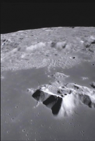
These kids have picked some really nice shots for MoonKam.
Quick animation of a few frames 
|
|
|
|
|
|
|
Sep 21 2012, 11:34 PM
Post
#36
|
|
|
Member Group: Members Posts: 102 Joined: 8-August 12 Member No.: 6511 |
So, decommissioning GRAIL. The mission will end in December 2012. Spaceflight 101 describes it as follows:
"When the science phase has ended, the final mission phase will begin. During a 5- to 7-day period, a Ka-Band calibration is made and GRAIL continue to provide science results as sunlight and power allows. Early in December, 2012, the GRAIL Mission ends. About 20 days after the end of this phase, the GRAIL Orbiters will impact the lunar surface because their orbits will not have been maintained. No special area has been targeted for impact." Earlier this year, Spaceflight Now said: "Mission planners are formulating ideas for the impact scenario, evaluating the possibility of aiming the crashes so they are within the field-of-view of instruments on NASA's Lunar Reconnaissance Orbiter." So, we're getting pretty close now -- December 2012 is just three months away. Has anyone heard anything about the decommissioning? Have impact sites been chosen? Doug M. |
|
|
|
|
Sep 30 2012, 03:18 PM
Post
#37
|
|
|
Solar System Cartographer Group: Members Posts: 10170 Joined: 5-April 05 From: Canada Member No.: 227 |
MoonKAM on GRAIL has taken over 100000 images now (I'm not sure if it is currently collecting images). There is a handy interface to them here:
https://moonkam.ucsd.edu/image_gallery/locations A zoomable map interface of the now almost ubiquitous design (give the designer of that interface a nobel prize or something) - you can search by various methods, then click on an icon and link to the image itself. (there's also a vast gallery but that is hard to find things in) Phil -------------------- ... because the Solar System ain't gonna map itself.
Also to be found posting similar content on https://mastodon.social/@PhilStooke Maps for download (free PD: https://upload.wikimedia.org/wikipedia/comm...Cartography.pdf NOTE: everything created by me which I post on UMSF is considered to be in the public domain (NOT CC, public domain) |
|
|
|
|
Sep 30 2012, 03:23 PM
Post
#38
|
|
|
Founder Group: Chairman Posts: 14432 Joined: 8-February 04 Member No.: 1 |
So we are extending the GRAIL/MoonKAM Eyes on the Solar System interface this coming week to include the extension, but even we don't have details in the final decommissioning. There's a big +/- in there, and no detail on the finality of it all yet.
|
|
|
|
|
Nov 5 2012, 11:31 PM
Post
#39
|
|
|
Junior Member Group: Members Posts: 78 Joined: 16-October 12 From: Pennsylvania Member No.: 6711 |
Any idea when the gravity map will be published? I can not seem to find any information on it. Is there one currently being made or is it not public yet?
The entire mission seems pretty uneventful so far. From what I remember there was a some excitement because GRAIL would be able to test the Two Moon hypothesis. What happened? Is it still a valid theory? Even if the gravity map isn't complete yet, if part of it seemed to suggest the above was correct I would expect at least some kind of announcement from NASA. Is everyone being hush, hush, instead? It's my first post so be gentle
|
|
|
|
|
Nov 5 2012, 11:53 PM
Post
#40
|
|
|
Solar System Cartographer Group: Members Posts: 10170 Joined: 5-April 05 From: Canada Member No.: 227 |
The mission is still in progress, currently acquiring higher resolution data, and it takes a lot of processing and analysis. The map is not released because it's not finished, and the interpretations can't be done properly until it is finished. It's not like an imaging mission where results are available on day 1. We know the mission will end in December, and I would expect very little serious detail to be published until (a) LPSC in March next year, or (
 the publication of a paper in Science or Nature, whichever comes first. So - be patient just a bit longer! the publication of a paper in Science or Nature, whichever comes first. So - be patient just a bit longer!Phil -------------------- ... because the Solar System ain't gonna map itself.
Also to be found posting similar content on https://mastodon.social/@PhilStooke Maps for download (free PD: https://upload.wikimedia.org/wikipedia/comm...Cartography.pdf NOTE: everything created by me which I post on UMSF is considered to be in the public domain (NOT CC, public domain) |
|
|
|
|
Nov 6 2012, 12:05 AM
Post
#41
|
|
|
Administrator Group: Admin Posts: 5172 Joined: 4-August 05 From: Pasadena, CA, USA, Earth Member No.: 454 |
Actually, at DPS they said that there was an article in preparation (I assume in Science) based on the prime mission data, and that they hoped but couldn't be certain that it'd be published around the time of AGU, which is in a month. But it sounds like the schedule's a bit tight for that. Hopefully before the end of the calendar year.
-------------------- My website - My Patreon - @elakdawalla on Twitter - Please support unmannedspaceflight.com by donating here.
|
|
|
|
|
Nov 24 2012, 10:39 PM
Post
#42
|
|
|
Solar System Cartographer Group: Members Posts: 10170 Joined: 5-April 05 From: Canada Member No.: 227 |
We are coming up to the end of GRAIL's extended mission. Has anyone heard anything about the final impact plans? Originally the impacts were to be untargeted, but later there were suggestions of impacts within view of LRO, or one impact in view of the other GRAIL's MoonKAM.
Phil -------------------- ... because the Solar System ain't gonna map itself.
Also to be found posting similar content on https://mastodon.social/@PhilStooke Maps for download (free PD: https://upload.wikimedia.org/wikipedia/comm...Cartography.pdf NOTE: everything created by me which I post on UMSF is considered to be in the public domain (NOT CC, public domain) |
|
|
|
|
Nov 25 2012, 06:06 AM
Post
#43
|
|
|
Administrator Group: Admin Posts: 5172 Joined: 4-August 05 From: Pasadena, CA, USA, Earth Member No.: 454 |
FWIW, I haven't heard a thing. That mission has pretty successfully flown under the media radar since it launched. I think some missions wish they had more attention, but I think GRAIL prefers operating in "stealth mode." Their science results will improve massively the more time they have to work with more data, so the longer nobody pays attention to them, the better they'll look when they do create a stir.
I wonder how far in advance they have to know where they're going to crash in order to attempt LRO observations of the impact? (I don't even know if LRO observations will be possible.) -------------------- My website - My Patreon - @elakdawalla on Twitter - Please support unmannedspaceflight.com by donating here.
|
|
|
|
|
Nov 27 2012, 09:52 PM
Post
#44
|
|
|
Solar System Cartographer Group: Members Posts: 10170 Joined: 5-April 05 From: Canada Member No.: 227 |
This is from spaceflight101, a very useful site:
http://www.spaceflight101.com/grail-mission-updates.html "A total of three additional Mapping Cycles are planned. On December 3, 2012, the mission will come to an end. A short period of decommissioning will be performed before the two spacecraft impact the lunar surface. To further increase science data return, Teams are currently evaluating a targeted Mission Termination meaning that the GRAIL Orbiters will make a targeted Crash on a picked site on the Lunar Surface that is in sight of instruments on NASAs Lunar Reconnaissance Orbiter. A decision on that will be made as the mission progresses and propellant is consumed to support the science phase of the mission." So LRO observations were considered earlier in the year... but did it turn out to be feasible? And (or) will it happen? We should know fairly soon, I guess. Phil -------------------- ... because the Solar System ain't gonna map itself.
Also to be found posting similar content on https://mastodon.social/@PhilStooke Maps for download (free PD: https://upload.wikimedia.org/wikipedia/comm...Cartography.pdf NOTE: everything created by me which I post on UMSF is considered to be in the public domain (NOT CC, public domain) |
|
|
|
|
Nov 27 2012, 10:12 PM
Post
#45
|
|
|
Administrator Group: Admin Posts: 5172 Joined: 4-August 05 From: Pasadena, CA, USA, Earth Member No.: 454 |
There's a press briefing at AGU on Wednesday next week. I won't be there in person, but Casey Dreier will be there representing the Planetary Society. I've asked him if he can ask this question. (I want to save my question for science
)
-------------------- My website - My Patreon - @elakdawalla on Twitter - Please support unmannedspaceflight.com by donating here.
|
|
|
|
|
Dec 2 2012, 07:38 PM
Post
#46
|
|
|
Solar System Cartographer Group: Members Posts: 10170 Joined: 5-April 05 From: Canada Member No.: 227 |
A wee update - MoonKAM was turned on for the extended mission and added some images to the gallery:
http://images.moonkam.ucsd.edu/v/mk12_10/ But now the camara has been affected by a solar flare - it can still be commanded but may not work, as I understand it. I don't know the date of the event yet. https://moonkam.ucsd.edu/news/moonkam_mission_interrupted Phil -------------------- ... because the Solar System ain't gonna map itself.
Also to be found posting similar content on https://mastodon.social/@PhilStooke Maps for download (free PD: https://upload.wikimedia.org/wikipedia/comm...Cartography.pdf NOTE: everything created by me which I post on UMSF is considered to be in the public domain (NOT CC, public domain) |
|
|
|
|
Dec 2 2012, 07:44 PM
Post
#47
|
|
|
Merciless Robot Group: Admin Posts: 8784 Joined: 8-December 05 From: Los Angeles Member No.: 602 |
Huh.
Please pardon my lack of memory here, but this is a straight-up off-the-shelf camera, isn't it (i.e., not rad-hardened)? If so, seems to have held up pretty well, esp. since we're just approaching the next solar max. -------------------- A few will take this knowledge and use this power of a dream realized as a force for change, an impetus for further discovery to make less ancient dreams real.
|
|
|
|
|
Dec 2 2012, 08:51 PM
Post
#48
|
|
|
Senior Member Group: Members Posts: 2517 Joined: 13-September 05 Member No.: 497 |
QUOTE (nprev @ Dec 2 2012, 12:44 PM) this is a straight-up off-the-shelf camera, isn't it (i.e., not rad-hardened)? It's not what I would call an "off-the-shelf" camera. http://eclipticenterprises.com/press_releases/928 As to not being "rad-hardened", it depends on what you mean by that. There have been several MSSS cameras (MRO MARCI and LROC WAC, for example) that aren't rad-hardened but can recover from radiation upsets. -------------------- Disclaimer: This post is based on public information only. Any opinions are my own.
|
|
|
|
|
Dec 2 2012, 09:16 PM
Post
#49
|
|
|
Merciless Robot Group: Admin Posts: 8784 Joined: 8-December 05 From: Los Angeles Member No.: 602 |
Hmm. Okay, thanks, Mike.
Wonder which event took them out? -------------------- A few will take this knowledge and use this power of a dream realized as a force for change, an impetus for further discovery to make less ancient dreams real.
|
|
|
|
|
Dec 5 2012, 04:23 PM
Post
#50
|
|
|
Solar System Cartographer Group: Members Posts: 10170 Joined: 5-April 05 From: Canada Member No.: 227 |
http://www.spaceflight101.com/grail-mission-updates.html
More news. It was over Thanksgiving. And the final fate of the spacecraft, targeted or not, is still not decided. Phil -------------------- ... because the Solar System ain't gonna map itself.
Also to be found posting similar content on https://mastodon.social/@PhilStooke Maps for download (free PD: https://upload.wikimedia.org/wikipedia/comm...Cartography.pdf NOTE: everything created by me which I post on UMSF is considered to be in the public domain (NOT CC, public domain) |
|
|
|
|
Dec 5 2012, 04:51 PM
Post
#51
|
|
|
Founder Group: Chairman Posts: 14432 Joined: 8-February 04 Member No.: 1 |
|
|
|
|
|
Dec 5 2012, 05:47 PM
Post
#52
|
|
|
Solar System Cartographer Group: Members Posts: 10170 Joined: 5-April 05 From: Canada Member No.: 227 |
Pics and maps here. A deeply fractured crust.
Phil http://www.nasa.gov/mission_pages/grail/mu...lery-index.html -------------------- ... because the Solar System ain't gonna map itself.
Also to be found posting similar content on https://mastodon.social/@PhilStooke Maps for download (free PD: https://upload.wikimedia.org/wikipedia/comm...Cartography.pdf NOTE: everything created by me which I post on UMSF is considered to be in the public domain (NOT CC, public domain) |
|
|
|
|
Dec 5 2012, 08:07 PM
Post
#53
|
|
 Senior Member Group: Members Posts: 1729 Joined: 3-August 06 From: 43° 35' 53" N 1° 26' 35" E Member No.: 1004 |
|
|
|
|
|
Dec 6 2012, 07:57 PM
Post
#54
|
|
|
Junior Member Group: Members Posts: 78 Joined: 16-October 12 From: Pennsylvania Member No.: 6711 |
Hmm. Looking over the maps doesn't seem to show any obvious discrepancy that would imply a low velocity impact. Thats one strike against the two moon hypothesis. Personally, I'm rather happy. Didn't like that theory much anyway. Our Moon is a unique object.
Anyway, excellent news! I hope NASA scientists can pull more info out of the new data in the future. For our closest neighbor, there is still a lot of unknowns about it. I would love it if they can find more specifics about the Thera-Earth collision. The moon's mantle should have some answers, or it could surprise us. Who knows? |
|
|
|
|
Dec 7 2012, 01:07 AM
Post
#55
|
|
|
Administrator Group: Admin Posts: 5172 Joined: 4-August 05 From: Pasadena, CA, USA, Earth Member No.: 454 |
I'm having trouble finding a Mercator-projected map of the Moon to compare to the GRAIL map. Does anybody know a digital one?
-------------------- My website - My Patreon - @elakdawalla on Twitter - Please support unmannedspaceflight.com by donating here.
|
|
|
|
|
Dec 7 2012, 01:43 AM
Post
#56
|
|
|
Solar System Cartographer Group: Members Posts: 10170 Joined: 5-April 05 From: Canada Member No.: 227 |
You could go here:
http://www.lpi.usra.edu/resources/mapcatalog/usgsTopo/ or other pages from this list: http://www.lpi.usra.edu/resources/mapcatalog/ But Mercator is not used very much these days as you know. One other option would be to make your own here: http://www.mapaplanet.org/explorer/moon.html Mercator is one of the options under Advanced Options. Choose the data set you want, set the projection and resolution you want... and the lat-long extent. Warning, for Mercator don't choose 90 north to 90 south (it would be infinitely large), but the GRAIL maps are cut off at about 70 N and S. Phil -------------------- ... because the Solar System ain't gonna map itself.
Also to be found posting similar content on https://mastodon.social/@PhilStooke Maps for download (free PD: https://upload.wikimedia.org/wikipedia/comm...Cartography.pdf NOTE: everything created by me which I post on UMSF is considered to be in the public domain (NOT CC, public domain) |
|
|
|
|
Dec 7 2012, 01:52 AM
Post
#57
|
|
|
Administrator Group: Admin Posts: 5172 Joined: 4-August 05 From: Pasadena, CA, USA, Earth Member No.: 454 |
Ah, I'd completely forgotten I could set the projection in map-a-planet. Thanks for the reminder.
Do you know why the lunar folks seem to like Mercator projection so much? -------------------- My website - My Patreon - @elakdawalla on Twitter - Please support unmannedspaceflight.com by donating here.
|
|
|
|
|
Dec 7 2012, 02:06 AM
Post
#58
|
|
|
Solar System Cartographer Group: Members Posts: 10170 Joined: 5-April 05 From: Canada Member No.: 227 |
It allows craters at mid- to high-latitudes to appear circular. Almost all traditional lunar sheet maps from ACIC, USGS etc. used conformal projections (Mercator, conformal conic, polar stereographic) with that special characteristic. Only with the advent of digital mapping have non-conformal (read: shape-distorting) projections like Simple Cylindrical (Equirectangular) or [shudder] Sinusoidal been used to any extent.
Phil -------------------- ... because the Solar System ain't gonna map itself.
Also to be found posting similar content on https://mastodon.social/@PhilStooke Maps for download (free PD: https://upload.wikimedia.org/wikipedia/comm...Cartography.pdf NOTE: everything created by me which I post on UMSF is considered to be in the public domain (NOT CC, public domain) |
|
|
|
|
Dec 7 2012, 02:58 AM
Post
#59
|
|
|
Senior Member Group: Members Posts: 2086 Joined: 13-February 10 From: Ontario Member No.: 5221 |
GRAIL talk starting pretty quick:
http://www.ustream.tv/nasajpl2 |
|
|
|
|
Dec 11 2012, 02:59 AM
Post
#60
|
|
|
Solar System Cartographer Group: Members Posts: 10170 Joined: 5-April 05 From: Canada Member No.: 227 |
"NASA will host a media teleconference at 10:30 a.m. PST (1:30 p.m. EST) Thursday, Dec. 13, to provide an overview of events leading up to twin spacecraft being commanded to impact the moon's surface on Dec. 17 at approximately 2:28 p.m. PST (5:28 p.m. EST). "
Phil -------------------- ... because the Solar System ain't gonna map itself.
Also to be found posting similar content on https://mastodon.social/@PhilStooke Maps for download (free PD: https://upload.wikimedia.org/wikipedia/comm...Cartography.pdf NOTE: everything created by me which I post on UMSF is considered to be in the public domain (NOT CC, public domain) |
|
|
|
|
Dec 12 2012, 12:36 AM
Post
#61
|
|
|
Senior Member Group: Members Posts: 1583 Joined: 14-October 05 From: Vermont Member No.: 530 |
Emily's discussion of the GRAIL results is top knotch:
http://www.planetary.org/blogs/emily-lakda...il-results.html |
|
|
|
|
Dec 12 2012, 03:32 AM
Post
#62
|
|
|
Merciless Robot Group: Admin Posts: 8784 Joined: 8-December 05 From: Los Angeles Member No.: 602 |
Indeed it is; world-class real science explanation, as per her usual.
So that's what happens when you give a talented planetary geologist a computer with word processing capability... 
-------------------- A few will take this knowledge and use this power of a dream realized as a force for change, an impetus for further discovery to make less ancient dreams real.
|
|
|
|
|
Dec 13 2012, 05:09 PM
Post
#63
|
|
|
Member Group: Members Posts: 252 Joined: 5-May 05 From: Mississippi (USA) Member No.: 379 |
Just a reminder
UPCOMING EVENT: NASA Moon Mission News 10:30 a.m. PST (13:30 EST) Thursday, Dec. 13 (18:30 UTC) LINK http://www.ustream.tv/nasajpl2 NASA will host a media teleconference to provide an overview of events leading up to twin spacecraft being commanded to impact the moon's surface on Dec. 17 at approximately 14:28 PST, (17:28 EST). (22:28 UTC) NASA's Gravity Recovery and Interior Laboratory (GRAIL) mission, whose two washing machine-sized probes were named Ebb and Flow by elementary school students in Bozeman, Mont., via a nationwide contest, have successfully completed their prime missions and have only days to go on their extended mission science collection. As planned, the duo is running low on fuel. They have been orbiting the moon since New Year's Eve and New Year's Day, respectively, giving scientists unprecedented detail about the moon's internal structure and composition. |
|
|
|
|
Dec 13 2012, 06:28 PM
Post
#64
|
|
|
Senior Member Group: Members Posts: 1729 Joined: 3-August 06 From: 43° 35' 53" N 1° 26' 35" E Member No.: 1004 |
from images of today's teleconf, the two spacecraft will hit an unnamed mountain 75 degrees north on monday evening (UTC)
http://www.nasa.gov/mission_pages/grail/ne...on20121213.html |
|
|
|
|
Dec 13 2012, 06:40 PM
Post
#65
|
|
|
Senior Member Group: Members Posts: 2086 Joined: 13-February 10 From: Ontario Member No.: 5221 |
Had no idea they 'caught' LRO up to now. Fascinating!
|
|
|
|
|
Dec 13 2012, 07:10 PM
Post
#66
|
|
|
Solar System Cartographer Group: Members Posts: 10170 Joined: 5-April 05 From: Canada Member No.: 227 |
The scattered fragments will be the most northerly artifacts on the lunar surface, for a while.
Phil -------------------- ... because the Solar System ain't gonna map itself.
Also to be found posting similar content on https://mastodon.social/@PhilStooke Maps for download (free PD: https://upload.wikimedia.org/wikipedia/comm...Cartography.pdf NOTE: everything created by me which I post on UMSF is considered to be in the public domain (NOT CC, public domain) |
|
|
|
|
Dec 14 2012, 01:09 AM
Post
#67
|
|
|
Solar System Cartographer Group: Members Posts: 10170 Joined: 5-April 05 From: Canada Member No.: 227 |
And speaking of locations... on the posted graphic the longitude is given as 26.63 degrees East. Oops - it's West! Yes, west of the prime meridian. You could call it 333.37 E if you prefer. Maybe that wacky lunar gravity is playing with the trajectory.
(I just noticed Emily has it right in her blog - well done!) Phil -------------------- ... because the Solar System ain't gonna map itself.
Also to be found posting similar content on https://mastodon.social/@PhilStooke Maps for download (free PD: https://upload.wikimedia.org/wikipedia/comm...Cartography.pdf NOTE: everything created by me which I post on UMSF is considered to be in the public domain (NOT CC, public domain) |
|
|
|
|
Dec 14 2012, 03:53 AM
Post
#68
|
|
 Member Group: Members Posts: 813 Joined: 8-February 04 From: Arabia Terra Member No.: 12 |
On the other side of the quality scale from Emily's fantastic work we have this from The Grauniad: http://www.guardian.co.uk/science/2012/dec...issance-orbiter
Someone alert the Planetary Protection Officer! |
|
|
|
|
Dec 14 2012, 04:19 AM
Post
#69
|
|
|
Solar System Cartographer Group: Members Posts: 10170 Joined: 5-April 05 From: Canada Member No.: 227 |
Let's hope they splash down safely!
Grauniad - that takes me back. Phil -------------------- ... because the Solar System ain't gonna map itself.
Also to be found posting similar content on https://mastodon.social/@PhilStooke Maps for download (free PD: https://upload.wikimedia.org/wikipedia/comm...Cartography.pdf NOTE: everything created by me which I post on UMSF is considered to be in the public domain (NOT CC, public domain) |
|
|
|
|
Dec 14 2012, 02:44 PM
Post
#70
|
|
|
Member Group: Members Posts: 252 Joined: 5-May 05 From: Mississippi (USA) Member No.: 379 |
QUOTE (SFJCody @ Dec 13 2012, 11:53 PM) Someone alert the Planetary Protection Officer! I read the article and couldn't see any major problems. However, when I got to the bottom there was an announcement. http://www.guardian.co.uk/science/2012/dec...issance-orbiter "This article was amended on 14 December to amend the subheading, which originally said the probes would "splash down" on the moon. The photograph was also changed; the original showed Saturn's moon Enceladus."
|
|
|
|
|
Dec 15 2012, 12:45 AM
Post
#71
|
|
|
Senior Member Group: Members Posts: 2086 Joined: 13-February 10 From: Ontario Member No.: 5221 |
Rocket burn complete, according to JPL.
Coverage starts at 2:00 PST. http://www.jpl.nasa.gov/news/news.php?release=2012-398b |
|
|
|
|
Dec 17 2012, 09:35 PM
Post
#72
|
|
|
Member Group: Members Posts: 102 Joined: 29-January 10 From: Poland Member No.: 5205 |
-------------------- Adam Hurcewicz from Poland
|
|
|
|
|
Dec 17 2012, 10:06 PM
Post
#73
|
|
|
Senior Member Group: Admin Posts: 3108 Joined: 21-December 05 From: Canberra, Australia Member No.: 615 |
Live broadcast on NASA TV now.
http://www.nasa.gov/multimedia/nasatv/index.html EDIT: Just a quick (from work) banner. |
|
|
|
|
Dec 17 2012, 10:27 PM
Post
#74
|
|
|
Senior Member Group: Members Posts: 2086 Joined: 13-February 10 From: Ontario Member No.: 5221 |
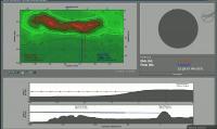
That cross-section chart updating every couple seconds is so cool. Minute left...
And it's done. Goodnight, grail. It's up to LRO to see what it can see when the sun comes up.... |
|
|
|
|
Dec 17 2012, 10:32 PM
Post
#75
|
||
|
Senior Member Group: Admin Posts: 3108 Joined: 21-December 05 From: Canberra, Australia Member No.: 615 |
Final resting place for Grail A&B is now named in honor of "Sally Ride".
http://www.jpl.nasa.gov/news/news.php?release=2012-401
|
|
|
|
|
|
|
Dec 18 2012, 12:25 AM
Post
#76
|
|
|
Junior Member Group: Members Posts: 78 Joined: 16-October 12 From: Pennsylvania Member No.: 6711 |
This was probably the most exciting moon mission possible next to a sample return or human landing.
Congratulations GRAIL! You've made history. |
|
|
|
|
Dec 18 2012, 01:55 AM
Post
#77
|
|
|
Senior Member Group: Members Posts: 2086 Joined: 13-February 10 From: Ontario Member No.: 5221 |
And two new holes in the ground at that

|
|
|
|
|
Dec 18 2012, 06:38 AM
Post
#78
|
||
|
Senior Member Group: Admin Posts: 3108 Joined: 21-December 05 From: Canberra, Australia Member No.: 615 |
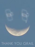
Just a final contribution...
Thank you GRAIL.
|
|
|
|
|
|
|
Dec 23 2012, 04:26 AM
Post
#79
|
|
|
Solar System Cartographer Group: Members Posts: 10170 Joined: 5-April 05 From: Canada Member No.: 227 |
Ebb, one of the GRAIL spacecraft, made some final images from very low orbit which can be seen here:
http://images.moonkam.ucsd.edu/v/ebbs_last_images/ Phil -------------------- ... because the Solar System ain't gonna map itself.
Also to be found posting similar content on https://mastodon.social/@PhilStooke Maps for download (free PD: https://upload.wikimedia.org/wikipedia/comm...Cartography.pdf NOTE: everything created by me which I post on UMSF is considered to be in the public domain (NOT CC, public domain) |
|
|
|
|
Dec 31 2012, 05:04 AM
Post
#80
|
|
|
Senior Member Group: Members Posts: 2086 Joined: 13-February 10 From: Ontario Member No.: 5221 |
Any news from LRO? I see nothing on the main website or camera's individual site. We're past full moon by now.
|
|
|
|
|
Dec 31 2012, 02:17 PM
Post
#81
|
|
|
Administrator Group: Admin Posts: 5172 Joined: 4-August 05 From: Pasadena, CA, USA, Earth Member No.: 454 |
Even if they do have an image, which they might not, I'm not surprised to see nothing right now. It's New Year's Eve, and last week was a holiday. NASA won't release something when they don't expect anybody will be paying attention.
-------------------- My website - My Patreon - @elakdawalla on Twitter - Please support unmannedspaceflight.com by donating here.
|
|
|
|
|
Jan 2 2013, 11:54 AM
Post
#82
|
|
|
Forum Contributor Group: Members Posts: 1372 Joined: 8-February 04 From: North East Florida, USA. Member No.: 11 |
QUOTE (elakdawalla @ Dec 31 2012, 03:17 PM) Even if they do have an image, which they might not, I'm not surprised to see nothing right now. It's New Year's Eve, and last week was a holiday. NASA won't release something when they don't expect anybody will be paying attention. Lol, that depends who you work for, last week was a 2 day break......Also I worked New Years eve too, as I am sure millions of us did. |
|
|
|
|
Jan 2 2013, 04:39 PM
Post
#83
|
|
|
Solar System Cartographer Group: Members Posts: 10170 Joined: 5-April 05 From: Canada Member No.: 227 |
One other point - LRO is in a higher orbit now so the small GRAIL craters will be very small in the images. It may be easier to locate them if the new images have illumination very similar to the older ones. That could take months to arrange. So I expect they will take images every time they are over the mountain, but any announcement might take longer.
Phil -------------------- ... because the Solar System ain't gonna map itself.
Also to be found posting similar content on https://mastodon.social/@PhilStooke Maps for download (free PD: https://upload.wikimedia.org/wikipedia/comm...Cartography.pdf NOTE: everything created by me which I post on UMSF is considered to be in the public domain (NOT CC, public domain) |
|
|
|
|
Jan 2 2013, 05:30 PM
Post
#84
|
|
|
Founder Group: Chairman Posts: 14432 Joined: 8-February 04 Member No.: 1 |
Moreover - just because a site is in sunlight doesn't mean LRO is going to be over it quickly - the groundtrack of the orbit has to be taken into consideration also and it might be several cycles ( lunar days ) before a good view is available.
|
|
|
|
|
Jan 11 2013, 01:33 AM
Post
#85
|
|
|
Solar System Cartographer Group: Members Posts: 10170 Joined: 5-April 05 From: Canada Member No.: 227 |
Final (or nearly final, not sure yet) video from GRAIL, three days before impact:
http://www.jpl.nasa.gov/video/index.php?id=1181 Phil -------------------- ... because the Solar System ain't gonna map itself.
Also to be found posting similar content on https://mastodon.social/@PhilStooke Maps for download (free PD: https://upload.wikimedia.org/wikipedia/comm...Cartography.pdf NOTE: everything created by me which I post on UMSF is considered to be in the public domain (NOT CC, public domain) |
|
|
|
|
Jan 11 2013, 04:29 AM
Post
#86
|
|
|
Newbie Group: Members Posts: 8 Joined: 29-August 11 Member No.: 6141 |
I found it interesting to realize that the 10km altitude of that video above the moon is about the same altitude as jet planes fly above Earth.
|
|
|
|
|
Jan 11 2013, 07:12 AM
Post
#87
|
|
|
Founder Group: Chairman Posts: 14432 Joined: 8-February 04 Member No.: 1 |
As far as I know - those were the last frames taken by MoonKAM - I got the raw frames from Sally Ride Science last week ( although they've been on their website for a while ) and just did a bit of deinterlacing and rotating to get the best I could out of them.
|
|
|
|
|
Jan 11 2013, 08:24 AM
Post
#88
|
|
|
Senior Member Group: Admin Posts: 3108 Joined: 21-December 05 From: Canberra, Australia Member No.: 615 |
Thoroughly impressed by the MoonKam project as an education tool.
Throughout 2012 I did as much as possible to encourage students to give it a try. Wonderful to see those final frames blended into such a great film. Nice job Doug. Can't wait to see the results from the JunoCam project in 2016. |
|
|
|
|
Jan 11 2013, 08:49 AM
Post
#89
|
|
 Member Group: Members Posts: 796 Joined: 27-February 08 From: Heart of Europe Member No.: 4057 |
Few weeks ago I did two animations from those images, but I was too lazy to finish my blog entry about them
.Faster version (timewarp 5×) is available here. Slow (~realtime) version is available here. My animations are without some images in the beginning of the NASA's video, because they weren't published (yet?).  . .
-------------------- |
|
|
|
|
Jan 11 2013, 04:59 PM
Post
#90
|
|
|
Senior Member Group: Members Posts: 2517 Joined: 13-September 05 Member No.: 497 |
QUOTE (Astro0 @ Jan 11 2013, 01:24 AM) Can't wait to see the results from the JunoCam project in 2016. Note that there is no hardware commonality between MoonKAM and Junocam. And you won't have to wait until 2016; the Juno Earth flyby is happening this year (9 October). -------------------- Disclaimer: This post is based on public information only. Any opinions are my own.
|
|
|
|
|
Jan 11 2013, 05:50 PM
Post
#91
|
|
|
Member Group: Members Posts: 115 Joined: 8-January 05 From: Austin | Texas Member No.: 138 |
QUOTE (Phil Stooke @ Jan 11 2013, 02:33 AM) Final (or nearly final, not sure yet) video from GRAIL, three days before impact: http://www.jpl.nasa.gov/video/index.php?id=1181 Phil Is it too late to send a message to Grail telling it to turn it's phone horizontal? |
|
|
|
|
Jan 11 2013, 07:00 PM
Post
#92
|
|
|
Founder Group: Chairman Posts: 14432 Joined: 8-February 04 Member No.: 1 |
The cameras were bolted to the spacecraft in that orientation probably about two years ago - and now lay smashed on the lunar surface.
I'm going to say yes...it's a bit too late. |
|
|
|
|
Jan 11 2013, 07:53 PM
Post
#93
|
|
|
Member Group: Members Posts: 115 Joined: 8-January 05 From: Austin | Texas Member No.: 138 |
QUOTE (djellison @ Jan 11 2013, 07:00 PM) The cameras were bolted to the spacecraft in that orientation probably about two years ago.... Yes, we know -- it was a joke. |
|
|
|
|
Jan 17 2013, 03:13 PM
Post
#94
|
||
|
Solar System Cartographer Group: Members Posts: 10170 Joined: 5-April 05 From: Canada Member No.: 227 |
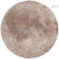
Here's an updated version of my Nearside Moon map with the GRAIL impacts added.
Phil
-------------------- ... because the Solar System ain't gonna map itself.
Also to be found posting similar content on https://mastodon.social/@PhilStooke Maps for download (free PD: https://upload.wikimedia.org/wikipedia/comm...Cartography.pdf NOTE: everything created by me which I post on UMSF is considered to be in the public domain (NOT CC, public domain) |
|
|
|
|
|
|
Jan 17 2013, 04:23 PM
Post
#95
|
|
|
Administrator Group: Admin Posts: 5172 Joined: 4-August 05 From: Pasadena, CA, USA, Earth Member No.: 454 |
Is this farside map of yours still current? Trying to make sure I have a matched set
-------------------- My website - My Patreon - @elakdawalla on Twitter - Please support unmannedspaceflight.com by donating here.
|
|
|
|
|
Jan 17 2013, 05:25 PM
Post
#96
|
|
|
Solar System Cartographer Group: Members Posts: 10170 Joined: 5-April 05 From: Canada Member No.: 227 |
Yes it is - no more farside impacts. Incidentally, Chandrayaan-1 was predicted to impact in 2012 as its orbit evolved, but as it was not tracked or trackable we don't know where it fell.
Phil -------------------- ... because the Solar System ain't gonna map itself.
Also to be found posting similar content on https://mastodon.social/@PhilStooke Maps for download (free PD: https://upload.wikimedia.org/wikipedia/comm...Cartography.pdf NOTE: everything created by me which I post on UMSF is considered to be in the public domain (NOT CC, public domain) |
|
|
|
|
Mar 19 2013, 10:47 PM
Post
#97
|
|
|
Junior Member Group: Members Posts: 59 Joined: 25-December 05 From: Stevens Point, Wisconsin, USA Member No.: 619 |
LROC spots craters formed by GRAIL probes (sorry I couldn't find the original paper in the conference abstracts):
http://science.nbcnews.com/_news/2013/03/1...oon-probes?lite |
|
|
|
|
Mar 19 2013, 10:55 PM
Post
#98
|
|
|
Merciless Robot Group: Admin Posts: 8784 Joined: 8-December 05 From: Los Angeles Member No.: 602 |
Wow. LROC is an impressive instrument indeed, and their science team is getting very good at this sort of thing. Well done!!!
-------------------- A few will take this knowledge and use this power of a dream realized as a force for change, an impetus for further discovery to make less ancient dreams real.
|
|
|
|
|
Mar 20 2013, 03:42 AM
Post
#99
|
|
|
Solar System Cartographer Group: Members Posts: 10170 Joined: 5-April 05 From: Canada Member No.: 227 |
There is no abstract, this was a press conference, not a paper. It's cool to see this even with LRO in its higher orbit.
Phil -------------------- ... because the Solar System ain't gonna map itself.
Also to be found posting similar content on https://mastodon.social/@PhilStooke Maps for download (free PD: https://upload.wikimedia.org/wikipedia/comm...Cartography.pdf NOTE: everything created by me which I post on UMSF is considered to be in the public domain (NOT CC, public domain) |
|
|
|
|
Mar 21 2013, 09:46 PM
Post
#100
|
|
|
Senior Member Group: Members Posts: 2998 Joined: 30-October 04 Member No.: 105 |
Better images and text at the NASA/LROC site:
http://www.nasa.gov/mission_pages/LRO/news...il-results.html -------------------- |
|
|
|
 |

|
Lo-Fi Version | Time is now: 28th May 2024 - 01:47 PM |
|
RULES AND GUIDELINES Please read the Forum Rules and Guidelines before posting. IMAGE COPYRIGHT |
OPINIONS AND MODERATION Opinions expressed on UnmannedSpaceflight.com are those of the individual posters and do not necessarily reflect the opinions of UnmannedSpaceflight.com or The Planetary Society. The all-volunteer UnmannedSpaceflight.com moderation team is wholly independent of The Planetary Society. The Planetary Society has no influence over decisions made by the UnmannedSpaceflight.com moderators. |
SUPPORT THE FORUM Unmannedspaceflight.com is funded by the Planetary Society. Please consider supporting our work and many other projects by donating to the Society or becoming a member. |
|