Yutu Route Map |

Yutu Route Map |
 Dec 15 2013, 04:30 PM Dec 15 2013, 04:30 PM
Post
#1
|
||
|
Solar System Cartographer  Group: Members Posts: 10193 Joined: 5-April 05 From: Canada Member No.: 227 |
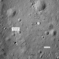
First route map! I will keep it going, mostly on LROC images, as I need it for a future project. I am still working on an accurate scale.
Phil
-------------------- ... because the Solar System ain't gonna map itself.
Also to be found posting similar content on https://mastodon.social/@PhilStooke Maps for download (free PD: https://upload.wikimedia.org/wikipedia/comm...Cartography.pdf NOTE: everything created by me which I post on UMSF is considered to be in the public domain (NOT CC, public domain) |
|
 |
 
|
|
 |
|
Dec 16 2013, 06:34 PM
Post
#2
|
|
 Administrator Group: Admin Posts: 5172 Joined: 4-August 05 From: Pasadena, CA, USA, Earth Member No.: 454 |
Now that we have six wheels on soil we need a dedicated route map thread
 The usual route map thread rules apply -- no chit-chat in there, keep it clean for just map updates. The usual route map thread rules apply -- no chit-chat in there, keep it clean for just map updates.
-------------------- My website - My Patreon - @elakdawalla on Twitter - Please support unmannedspaceflight.com by donating here.
|
|
|
|
|
Dec 16 2013, 10:30 PM
Post
#3
|
|
 Member Group: Members Posts: 559 Joined: 1-May 06 From: Scotland (Ecosse, Escocia) Member No.: 759 |
Could we re-post the landing site location images here, so all the relevant mapping material is in the one place?
|
|
|
|
|
Dec 17 2013, 10:27 PM
Post
#4
|
||
 Member Group: Members Posts: 124 Joined: 3-September 12 From: Almeria, SE Spain Member No.: 6632 |
Yes, we can.
Thorsten |
|
|
|
|
|
|
Dec 19 2013, 11:53 AM
Post
#5
|
|
|
Member Group: Members Posts: 559 Joined: 1-May 06 From: Scotland (Ecosse, Escocia) Member No.: 759 |
Thanks, Thorsten and Phil,
I watched a lot of CNTV live stream after the deployment of Yutu, and in one of the interviews an engineer showed a map of the early stages of the Rover's intended route. It showed a curved route going down the east side of the lander, which was said to be in order to photograph the sunlit side of the Lander (which makes sense). It then came in behind the south side of the Lander (I think they said to photograph the Chinese flag on the Lander ), and made a short move directly further south. There were 3 or 4 stops marked with blobs, indicating mutual photo stops. Unfortunately this was up too fast for me to get a screen grab. I have searched the several clips from that coverage here and elsewhere, but that part does not appear to be one that was clipped and posted for later re-play. China TV English Chang'e Report |
|
|
|
|
Dec 19 2013, 12:00 PM
Post
#6
|
|
|
Solar System Cartographer Group: Members Posts: 10193 Joined: 5-April 05 From: Canada Member No.: 227 |
-------------------- ... because the Solar System ain't gonna map itself.
Also to be found posting similar content on https://mastodon.social/@PhilStooke Maps for download (free PD: https://upload.wikimedia.org/wikipedia/comm...Cartography.pdf NOTE: everything created by me which I post on UMSF is considered to be in the public domain (NOT CC, public domain) |
|
|
|
|
Dec 20 2013, 08:18 PM
Post
#7
|
|||
 Junior Member Group: Members Posts: 37 Joined: 21-December 05 Member No.: 614 |
Based on the new panorama, this is what I would suggest for a map update.
Attached thumbnail(s)
|
||
|
|
|
||
|
Dec 20 2013, 08:38 PM
Post
#8
|
|
|
Solar System Cartographer Group: Members Posts: 10193 Joined: 5-April 05 From: Canada Member No.: 227 |
I agree... I was holding off until I knew which date the new images were taken, but I'm sure you are right.
Phil -------------------- ... because the Solar System ain't gonna map itself.
Also to be found posting similar content on https://mastodon.social/@PhilStooke Maps for download (free PD: https://upload.wikimedia.org/wikipedia/comm...Cartography.pdf NOTE: everything created by me which I post on UMSF is considered to be in the public domain (NOT CC, public domain) |
|
|
|
|
Dec 21 2013, 03:51 AM
Post
#9
|
||
|
Solar System Cartographer Group: Members Posts: 10193 Joined: 5-April 05 From: Canada Member No.: 227 |
My update of the map...
Phil
-------------------- ... because the Solar System ain't gonna map itself.
Also to be found posting similar content on https://mastodon.social/@PhilStooke Maps for download (free PD: https://upload.wikimedia.org/wikipedia/comm...Cartography.pdf NOTE: everything created by me which I post on UMSF is considered to be in the public domain (NOT CC, public domain) |
|
|
|
|
|
|
Dec 21 2013, 11:11 PM
Post
#10
|
||
|
Solar System Cartographer Group: Members Posts: 10193 Joined: 5-April 05 From: Canada Member No.: 227 |
I have modified the map to include the 21 December drive and also to fit the new Chinese map.
Phil
-------------------- ... because the Solar System ain't gonna map itself.
Also to be found posting similar content on https://mastodon.social/@PhilStooke Maps for download (free PD: https://upload.wikimedia.org/wikipedia/comm...Cartography.pdf NOTE: everything created by me which I post on UMSF is considered to be in the public domain (NOT CC, public domain) |
|
|
|
|
|
|
Dec 22 2013, 03:23 PM
Post
#11
|
||
|
Solar System Cartographer Group: Members Posts: 10193 Joined: 5-April 05 From: Canada Member No.: 227 |
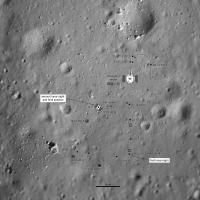
Update to 22 December - but the exact location is not certain and is subject to correction (as it will usually be)
Phil
-------------------- ... because the Solar System ain't gonna map itself.
Also to be found posting similar content on https://mastodon.social/@PhilStooke Maps for download (free PD: https://upload.wikimedia.org/wikipedia/comm...Cartography.pdf NOTE: everything created by me which I post on UMSF is considered to be in the public domain (NOT CC, public domain) |
|
|
|
|
|
|
Dec 23 2013, 03:22 PM
Post
#12
|
|
|
Member Group: Members Posts: 559 Joined: 1-May 06 From: Scotland (Ecosse, Escocia) Member No.: 759 |
Total distance travelled to date, according to Xinhua today...
"The six-wheeled rover started moving again after shutting down its subsystems on Dec. 16, and has traveled about 21 meters as of 8:05 p.m. Beijing Time on Saturday, according to the BACC." |
|
|
|
|
Dec 24 2013, 08:37 AM
Post
#13
|
|
 Senior Member Group: Members Posts: 1089 Joined: 19-February 05 From: Close to Meudon Observatory in France Member No.: 172 |
QUOTE (Phil Stooke @ Dec 22 2013, 04:23 PM)  Update to 22 December - but the exact location is not certain and is subject to correction (as it will usually be) Phil Phil you are definitely one of the BEST planetary cartographers in the world. I mean it : you succeed so well in adding locations on the Moon for a probe and its rover for which we have barely (as Westerners) no hi-res imaging data at all (and I would say with no access to an outreach policy as we have in Europe or in the USA). CONGRATULATIONS, Phil ! (and Merry XMas) 
|
|
|
|
|
Dec 24 2013, 09:24 PM
Post
#14
|
|
 Senior Member Group: Members Posts: 1729 Joined: 3-August 06 From: 43° 35' 53" N 1° 26' 35" E Member No.: 1004 |
this link (in Chinese) gives some details of the future objectives of Yutu's traverses:
http://news.xinhuanet.com/mil/2013-12/24/c_118692396.htm a "large stone pyramid" about 42 meters SW of the lander, the a high ground to the W and a crater 10 m to the N. the link also gives some detail of the driving sessions. |
|
|
|
|
Dec 24 2013, 10:06 PM
Post
#15
|
|
|
Solar System Cartographer Group: Members Posts: 10193 Joined: 5-April 05 From: Canada Member No.: 227 |
The pyramid will be the large rock in the corner of my route map (and its pyramid shape well seen in the circular pan I posted). The high ground is most likely the rim of the 60 m diameter crater west of the lander, bristling with rocks in the panorama view. The other crater is probably the blocky one just north of the lander. After that the article says they are contemplating a strategic path for long term objectives.
Phil -------------------- ... because the Solar System ain't gonna map itself.
Also to be found posting similar content on https://mastodon.social/@PhilStooke Maps for download (free PD: https://upload.wikimedia.org/wikipedia/comm...Cartography.pdf NOTE: everything created by me which I post on UMSF is considered to be in the public domain (NOT CC, public domain) |
|
|
|
|
Dec 28 2013, 09:52 PM
Post
#16
|
||
|
Solar System Cartographer Group: Members Posts: 10193 Joined: 5-April 05 From: Canada Member No.: 227 |
This is a very tentative map update. We have no images to help with the current position, but there is a report that the rover is 40 m south of the lander and 'a little bit left' which I am interpreting to mean left on a north-up map, not left as the rover drove.
So... position is very tentative and the shape of the route unknown, and even the date of the drive is uncertain. So all this may be changed later. But for now it's the best we can do. Phil
-------------------- ... because the Solar System ain't gonna map itself.
Also to be found posting similar content on https://mastodon.social/@PhilStooke Maps for download (free PD: https://upload.wikimedia.org/wikipedia/comm...Cartography.pdf NOTE: everything created by me which I post on UMSF is considered to be in the public domain (NOT CC, public domain) |
|
|
|
|
|
|
Dec 30 2013, 11:36 PM
Post
#17
|
||
|
Senior Member Group: Members Posts: 1089 Joined: 19-February 05 From: Close to Meudon Observatory in France Member No.: 172 |
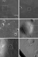
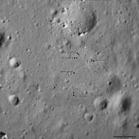
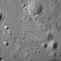
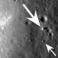
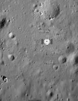
QUOTE (Phil Stooke @ Dec 28 2013, 10:52 PM) So... position is very tentative and the shape of the route unknown, and even the date of the drive is uncertain. So all this may be changed later. But for now it's the best we can do. Phil Great : you did it quite good Phil ! Here is the LRO image : congratulations to you again for your new Yu-Tu positioning close to the spot on the LRO image (small arrow) with almost no data at all ...and Happy NEW YEAR's Eve !
|
|
|
|
|
|
|
Dec 31 2013, 02:44 AM
Post
#18
|
|
|
Founder Group: Chairman Posts: 14433 Joined: 8-February 04 Member No.: 1 |
QUOTE (vikingmars @ Dec 30 2013, 03:36 PM) Here is the LRO image HERE is the LRO Image. http://lroc.sese.asu.edu/news/index.php?/a...From-Above.html |
|
|
|
|
Dec 31 2013, 02:47 AM
Post
#19
|
||
|
Solar System Cartographer Group: Members Posts: 10193 Joined: 5-April 05 From: Canada Member No.: 227 |
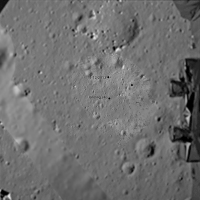
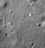
Merci! Here's another update including a sketch of the lander - though I'm not sure of the exact dimensions of the lander... and corrected to use the LRO position for Yutu.
Since we will presumably never have daily status reports, this map will always be a work in progress, updated from every scrap of information we get. Phil
-------------------- ... because the Solar System ain't gonna map itself.
Also to be found posting similar content on https://mastodon.social/@PhilStooke Maps for download (free PD: https://upload.wikimedia.org/wikipedia/comm...Cartography.pdf NOTE: everything created by me which I post on UMSF is considered to be in the public domain (NOT CC, public domain) |
|
|
|
|
|
|
Dec 31 2013, 03:32 AM
Post
#20
|
|
|
Senior Member Group: Members Posts: 2091 Joined: 13-February 10 From: Ontario Member No.: 5221 |
LRO can make up for the lack of reports quite easily, given the regular flyover schedule. I expect you'll miss learning any creative names they give to sites and targets more Phil (if they even have more than numbers)!
|
|
|
|
|
Dec 31 2013, 04:00 AM
Post
#21
|
|
|
Solar System Cartographer Group: Members Posts: 10193 Joined: 5-April 05 From: Canada Member No.: 227 |
I'm hoping for a few names!
Phil -------------------- ... because the Solar System ain't gonna map itself.
Also to be found posting similar content on https://mastodon.social/@PhilStooke Maps for download (free PD: https://upload.wikimedia.org/wikipedia/comm...Cartography.pdf NOTE: everything created by me which I post on UMSF is considered to be in the public domain (NOT CC, public domain) |
|
|
|
|
Jan 15 2014, 12:12 AM
Post
#22
|
||
|
Solar System Cartographer Group: Members Posts: 10193 Joined: 5-April 05 From: Canada Member No.: 227 |
Map update to 14 January - I don't know the date of the drive or the path, so this is conjectural, but the position should be OK. Since the last map I have corrected the size of the lander.
(EDIT - replaced with an update with the latest position, but I'm leaving it undated until I know more) Phil
-------------------- ... because the Solar System ain't gonna map itself.
Also to be found posting similar content on https://mastodon.social/@PhilStooke Maps for download (free PD: https://upload.wikimedia.org/wikipedia/comm...Cartography.pdf NOTE: everything created by me which I post on UMSF is considered to be in the public domain (NOT CC, public domain) |
|
|
|
|
|
|
Jan 19 2014, 08:32 PM
Post
#23
|
||
|
Junior Member Group: Members Posts: 45 Joined: 18-July 05 Member No.: 439 |
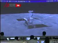
In a Chinese news report from Jan 14 current position was pictured as -32.61 meters (south) and -24.63 meters (west). Can't say what frame is in use -- either from lander or from the X point at the end of rails. The third number (27.17) relates to Yutu's attitude. The one to the right (129.23) is the Sun azimuth. There's also the fifth number outside of this frame -- Sun elevation (34.42 or so). Hope this helps to check/correct Phil's map.
Attached thumbnail(s)
|
|
|
|
|
|
|
Jan 19 2014, 10:45 PM
Post
#24
|
|
|
Junior Member Group: Members Posts: 45 Joined: 18-July 05 Member No.: 439 |
Similar data were found for points A (15 Dec 2013) and E (22 Dec 2013). With reservations about guessing blurred figures, here are these:
Point A -- 9.03 N, 1.55 E, Az = -171.08 Point E -- 30.97 S, 0.64 W, Az = 174.80 As LRO found Yutu to rest some 30-31 meters from CE3, we should believe positions are consistently measured from CE3. Jia Yang's 'more than 40 meters' may be from point X -- or even along the track. |
|
|
|
|
Jan 19 2014, 11:42 PM
Post
#25
|
||
|
Solar System Cartographer Group: Members Posts: 10193 Joined: 5-April 05 From: Canada Member No.: 227 |
Interesting! Here is my map with a 10 m grid superimposed and aligned with the lander. The coordinates match the Jan. 14 position well, except 'point E' refers to the point south of my E.
Phil
-------------------- ... because the Solar System ain't gonna map itself.
Also to be found posting similar content on https://mastodon.social/@PhilStooke Maps for download (free PD: https://upload.wikimedia.org/wikipedia/comm...Cartography.pdf NOTE: everything created by me which I post on UMSF is considered to be in the public domain (NOT CC, public domain) |
|
|
|
|
|
|
Jan 20 2014, 01:13 AM
Post
#26
|
|
|
Junior Member Group: Members Posts: 45 Joined: 18-July 05 Member No.: 439 |
Phil, you are right and I was wrong!
What I referred to as point E was in fact point of night sleep, recorded on December 26 and January 8. |
|
|
|
|
Feb 23 2014, 04:20 PM
Post
#27
|
||
|
Solar System Cartographer Group: Members Posts: 10193 Joined: 5-April 05 From: Canada Member No.: 227 |
As you know there has been very little information since mid-January. I have updated this map to suggest where we might be based on three very uncertain thoughts.
1. The direction the lander is viewed from in the most recent image. 2. A statement that the distance driven was 'over 100 m' which I interpret as 'only slightly over 100 m'. 3. An earlier statement that the big rock was a target for the rover instruments. Phil
-------------------- ... because the Solar System ain't gonna map itself.
Also to be found posting similar content on https://mastodon.social/@PhilStooke Maps for download (free PD: https://upload.wikimedia.org/wikipedia/comm...Cartography.pdf NOTE: everything created by me which I post on UMSF is considered to be in the public domain (NOT CC, public domain) |
|
|
|
|
|
|
Feb 23 2014, 04:31 PM
Post
#28
|
|
|
Administrator Group: Admin Posts: 5172 Joined: 4-August 05 From: Pasadena, CA, USA, Earth Member No.: 454 |
I'm sort of surprised we haven't seen any further photos from LROC that would help localize the rover.
-------------------- My website - My Patreon - @elakdawalla on Twitter - Please support unmannedspaceflight.com by donating here.
|
|
|
|
|
Feb 23 2014, 05:34 PM
Post
#29
|
|
|
Solar System Cartographer Group: Members Posts: 10193 Joined: 5-April 05 From: Canada Member No.: 227 |
Yes, we are overdue - some were expected during day 2 but have not been released (if taken). I could really use an LROC-NAC about now!
Phil -------------------- ... because the Solar System ain't gonna map itself.
Also to be found posting similar content on https://mastodon.social/@PhilStooke Maps for download (free PD: https://upload.wikimedia.org/wikipedia/comm...Cartography.pdf NOTE: everything created by me which I post on UMSF is considered to be in the public domain (NOT CC, public domain) |
|
|
|
|
Feb 24 2014, 05:32 PM
Post
#30
|
|
|
Administrator Group: Admin Posts: 5172 Joined: 4-August 05 From: Pasadena, CA, USA, Earth Member No.: 454 |
Since it took me a while to dig it up, I'll post in here a link to Mark Robinson's LPSC abstract on LROC imaging of the Chang'e 3 landing site, and a clip of the table of information on planned images:
CODE Image Sample Line Incidence Emission Phase Scale (m/px) Date
M102285549LE 2645 48154 -81 2 82 1.7 2009-07-15 M181302794LE 2478 39772 -72 2 74 1.6 2012-01-15 M183661683LE 4784 22098 -54 0 54 1.6 2012-02-12 M1116664800RE 3639 6405 -44 2 44 1.5 2013-02-28 M1127248516RE 2283 33974 -76 1 75 1.5 2013-06-30 M1129602407LE 2846 31480 -59 2 60 1.6 2013-07-27 M1142554338LE 4549 15684 -74 33 106 1.8 2013-12-24 M1142568554LE 4184 20330 -75 17 92 1.6 2013-12-24 M1142582775RE 1550 20621 -77 2 75 1.5 2013-12-25 M1142596997RE 845 20800 -78 20 58 1.6 2013-12-25 M1142625444RE 1477 16571 -81 48 36 2.1 2013-12-25 M1142682346RE 1112 10474 -87 72 21 3.8 2013-12-26 Table 1. Summary of LROC NAC images and pixel coordinates of Chang'e 3 lander, entries in italics acquired after landing. Future imaging opportunities occur 2014-01-22, 2014-02-19, 2014-03-19. Negative incidence angle indicates Sun from the west. -------------------- My website - My Patreon - @elakdawalla on Twitter - Please support unmannedspaceflight.com by donating here.
|
|
|
|
|
Feb 26 2014, 02:14 AM
Post
#31
|
||
|
Solar System Cartographer Group: Members Posts: 10193 Joined: 5-April 05 From: Canada Member No.: 227 |
I am updating my route map to show a new estimate of the current position which has been relayed to me privately. That does not mean it is official or certain, only that it is suggested by somebody with connections. I hope to learn more at LPSC.
Phil
-------------------- ... because the Solar System ain't gonna map itself.
Also to be found posting similar content on https://mastodon.social/@PhilStooke Maps for download (free PD: https://upload.wikimedia.org/wikipedia/comm...Cartography.pdf NOTE: everything created by me which I post on UMSF is considered to be in the public domain (NOT CC, public domain) |
|
|
|
|
|
|
Feb 26 2014, 03:22 AM
Post
#32
|
|
|
Administrator Group: Admin Posts: 5172 Joined: 4-August 05 From: Pasadena, CA, USA, Earth Member No.: 454 |
While the apparent closeness of the lander in the most recent images had made me think it likely they had moved closer, I clearly wasn't confident enough about that to say anything publicly. I would really love an LROC image right about now!
-------------------- My website - My Patreon - @elakdawalla on Twitter - Please support unmannedspaceflight.com by donating here.
|
|
|
|
|
Feb 26 2014, 03:42 PM
Post
#33
|
|
 Senior Member Group: Members Posts: 4252 Joined: 17-January 05 Member No.: 152 |
If the distance between the L and R cameras is known (big if?), or could be measured from a lander photo, it would be simple to measure the distance from the lander in the new stereo pair.
|
|
|
|
|
Feb 26 2014, 04:08 PM
Post
#34
|
|
|
Member Group: Admin Posts: 976 Joined: 29-September 06 From: Pasadena, CA - USA Member No.: 1200 |
Not necessarily. The relative position of the two cameras have huge effects on triangulation. On the other hand if in the image you had features of known size and distance, you could estimate the size and distance of other objects.
Paolo -------------------- Disclaimer: all opinions, ideas and information included here are my own,and should not be intended to represent opinion or policy of my employer.
|
|
|
|
|
Feb 26 2014, 04:19 PM
Post
#35
|
|
|
Senior Member Group: Members Posts: 4252 Joined: 17-January 05 Member No.: 152 |
Yes, that's what I meant - if you knew the relative separation of the L and R rover cameras, then you can find the distance to the lander. I know information is sparse with this mission. But it may be possible to measure the L/R separation from a lander photo of the rover at known distance, or simply by comparing the L/R separation to the total width of the rover, if that's known reasonably well.
Knowing the L/R separation of the rover cameras (orthogonal to their optical axes), then it's a simple matter of trig to convert the measured parallax between the lander and the distant horizon (effectively at infinity) to the lander distance. (Maybe this is what you meant Paolo - without an absolute direction reference, we could not do this, since the L/R optical axes may not be parallel. But we do have such a reference, given by features on the distant horizon in the images.) |
|
|
|
|
Feb 26 2014, 05:20 PM
Post
#36
|
|
|
Founder Group: Chairman Posts: 14433 Joined: 8-February 04 Member No.: 1 |
QUOTE (fredk @ Feb 26 2014, 08:19 AM) if you knew the relative separation of the L and R rover cameras AND the degree of toe in, if any. |
|
|
|
|
Feb 26 2014, 05:29 PM
Post
#37
|
|
|
Member Group: Admin Posts: 976 Joined: 29-September 06 From: Pasadena, CA - USA Member No.: 1200 |
QUOTE (fredk @ Feb 26 2014, 08:19 AM) ... (Maybe this is what you meant Paolo - without an absolute direction reference, we could not do this, since the L/R optical axes may not be parallel. But we do have such a reference, given by features on the distant horizon in the images.) Yes, that's what I meant. There is some literature on uncalibrated stereo but worked very little on that topic. Features on the horizon might be helpful to determine the vergence but you still need an object of known size in the images. Paolo -------------------- Disclaimer: all opinions, ideas and information included here are my own,and should not be intended to represent opinion or policy of my employer.
|
|
|
|
|
Feb 26 2014, 06:46 PM
Post
#38
|
|
|
Senior Member Group: Members Posts: 4252 Joined: 17-January 05 Member No.: 152 |
QUOTE (djellison @ Feb 26 2014, 05:20 PM) AND the degree of toe in, if any. That can be measured in pixels by looking at the shift in features on the distant horizon (effectively at infinity).The basic problem is that we need to know the pixel scale of the camera to convert pixels to an angle. Equivalently, as Paolo says, we need an object of known size and distance to give us a known angle. I'm used to MER/MSL, where we have that info easily available. But I'm guessing that's not the case with this mission. In principle, we could estimate the pixel scale since we have 360 degree pans. So if we can match distant features between the 360 and these new L/R images, we could estimate angles. Or, we could look at rover pancam images from the first lunar days and estimate the pixel scale from the (presumably) known size of the lander and distance from Phil's map. Then you have to assume/guess that those images are full frame rather than cropped. Either way, a lot of work. |
|
|
|
|
Mar 4 2014, 08:00 PM
Post
#39
|
||
|
Solar System Cartographer Group: Members Posts: 10193 Joined: 5-April 05 From: Canada Member No.: 227 |
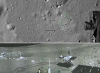
Very quick update based on the new LROC images.
Very interesting! If you look back you will see that the two southern points I mapped earlier were from big display screens in the control room. But of course they might have been target positions rather than real positions. The fact that we never saw a close-up image of the big rock suggests they did not get right up beside it. The tracks are not resolved well enough to be certain of the path here and they might have gone closer. Phil -------------------- ... because the Solar System ain't gonna map itself.
Also to be found posting similar content on https://mastodon.social/@PhilStooke Maps for download (free PD: https://upload.wikimedia.org/wikipedia/comm...Cartography.pdf NOTE: everything created by me which I post on UMSF is considered to be in the public domain (NOT CC, public domain) |
|
|
|
|
|
|
Mar 4 2014, 10:42 PM
Post
#40
|
|
|
Senior Member Group: Members Posts: 3516 Joined: 4-November 05 From: North Wales Member No.: 542 |
That's very strange. I'm looking at the same images and seeing a simpler track closer to your original one, Phil. Where do you get all the new zigzags from? (And why would they execute them anyway?)
|
|
|
|
|
Mar 4 2014, 11:12 PM
Post
#41
|
|
|
Solar System Cartographer Group: Members Posts: 10193 Joined: 5-April 05 From: Canada Member No.: 227 |
I overlaid the image on my map to get the location exactly right. Other than that it's a matter of interpretation, which marking is part of the track. But I will be looking at it again for a more finished version.
Phil -------------------- ... because the Solar System ain't gonna map itself.
Also to be found posting similar content on https://mastodon.social/@PhilStooke Maps for download (free PD: https://upload.wikimedia.org/wikipedia/comm...Cartography.pdf NOTE: everything created by me which I post on UMSF is considered to be in the public domain (NOT CC, public domain) |
|
|
|
|
Mar 23 2014, 06:43 PM
Post
#42
|
||
|
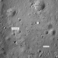
Solar System Cartographer Group: Members Posts: 10193 Joined: 5-April 05 From: Canada Member No.: 227 |
This is a new version of the route map, as complete as I can make it now.
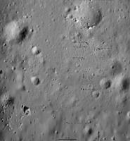
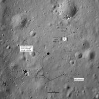
It is based on Chinese maps from the first lunar day, near the lander, and a Chinese map shown at LPSC, modified from my own examination of tracks in images, including a vertical projection of tracks from the middle of day 2, also shown at LPSC. The rover location is from the LROC images and it slightly updates the Chinese map shown at LPSC. Dots are stops between drives, and square symbols are science locations shown on the Chinese map. The dates shown for each stop are my estimates but they may not be correct, as we have almost no reliable information to go on. The rover is shown to scale (approximately) but I don't know its orientation. Phil
-------------------- ... because the Solar System ain't gonna map itself.
Also to be found posting similar content on https://mastodon.social/@PhilStooke Maps for download (free PD: https://upload.wikimedia.org/wikipedia/comm...Cartography.pdf NOTE: everything created by me which I post on UMSF is considered to be in the public domain (NOT CC, public domain) |
|
|
|
|
|
|
Apr 14 2014, 07:28 AM
Post
#43
|
||
|
Junior Member Group: Members Posts: 31 Joined: 10-January 14 Member No.: 7094 |
I have read a new magazine
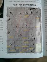
科学世界/Newton , 2014, issue 4: http://www.kxsj.com/html/zixundongtai/zixu...320/103649.html it gave us a official yutu route map
Attached thumbnail(s)
|
|
|
|
|
|
|
Apr 14 2014, 11:09 AM
Post
#44
|
|
|
Solar System Cartographer Group: Members Posts: 10193 Joined: 5-April 05 From: Canada Member No.: 227 |
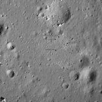
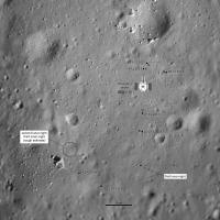
This is the same map shown on a poster at LPSC in March. My map was based on the new map, but there are places where other information was used to add to my map, especially images of tracks. If you compare this with the LRO image you see that the final rover location is further NE than the site at the end of this map.
Phil -------------------- ... because the Solar System ain't gonna map itself.
Also to be found posting similar content on https://mastodon.social/@PhilStooke Maps for download (free PD: https://upload.wikimedia.org/wikipedia/comm...Cartography.pdf NOTE: everything created by me which I post on UMSF is considered to be in the public domain (NOT CC, public domain) |
|
|
|
|
Apr 14 2014, 06:31 PM
Post
#45
|
|
|
Junior Member Group: Members Posts: 45 Joined: 18-July 05 Member No.: 439 |
Numbers of positions appear to be straightforward: Nddnn points to lunar day dd, point nn, and a sequential number is added in paretheses. But what is E2, S3, N and H?
|
|
|
|
|
Jun 11 2014, 11:03 PM
Post
#46
|
||
|
Solar System Cartographer Group: Members Posts: 10193 Joined: 5-April 05 From: Canada Member No.: 227 |
I have updated this map to include the newly named rock. I may change this as I learn more about it. Sites with squares are the main science sites (use of APXS or other instruments).
Phil
-------------------- ... because the Solar System ain't gonna map itself.
Also to be found posting similar content on https://mastodon.social/@PhilStooke Maps for download (free PD: https://upload.wikimedia.org/wikipedia/comm...Cartography.pdf NOTE: everything created by me which I post on UMSF is considered to be in the public domain (NOT CC, public domain) |
|
|
|
|
|
|
Sep 24 2014, 11:39 PM
Post
#47
|
|
|
Solar System Cartographer Group: Members Posts: 10193 Joined: 5-April 05 From: Canada Member No.: 227 |
I have just been to a meeting with Long Xiao in which he showed results from a paper submitted but not yet accepted. It contains a wonderful route map which I will use to update mine (giving accurate dates at the various stops in Day 2, for instance) as well as several unofficial crater names. There are other very good results including a fascinating interpretation of the ground-penetrating radar data.
I will post an updated version of my map when the new one becomes public. Phil -------------------- ... because the Solar System ain't gonna map itself.
Also to be found posting similar content on https://mastodon.social/@PhilStooke Maps for download (free PD: https://upload.wikimedia.org/wikipedia/comm...Cartography.pdf NOTE: everything created by me which I post on UMSF is considered to be in the public domain (NOT CC, public domain) |
|
|
|
|
Oct 21 2014, 07:00 PM
Post
#48
|
|
|
Senior Member Group: Members Posts: 1729 Joined: 3-August 06 From: 43° 35' 53" N 1° 26' 35" E Member No.: 1004 |
been reading a few papers presented at this year's IAC congress. according to this one: A Priority Method of cruise direction for the Lunar Rover Yutu traveled a total of 118.9 m. the paper also includes a route map
|
|
|
|
|
Nov 24 2014, 07:03 PM
Post
#49
|
||
|
Solar System Cartographer Group: Members Posts: 10193 Joined: 5-April 05 From: Canada Member No.: 227 |
This is a version of my route map (route still needs to be updated) with the new feature names just published in this paper:
http://www.raa-journal.org/raa/index.php/r...ticle/view/1962 The names are Chinese traditional names for constellations. The big crater west of the landing site is 'Purple Palace', a name for a region of the sky. These are not the same names I referred to a few posts above. I will say more about them as soon as I see them again. Phil
-------------------- ... because the Solar System ain't gonna map itself.
Also to be found posting similar content on https://mastodon.social/@PhilStooke Maps for download (free PD: https://upload.wikimedia.org/wikipedia/comm...Cartography.pdf NOTE: everything created by me which I post on UMSF is considered to be in the public domain (NOT CC, public domain) |
|
|
|
|
|
|
Nov 24 2014, 07:56 PM
Post
#50
|
|
|
Senior Member Group: Members Posts: 1074 Joined: 21-September 07 From: Québec, Canada Member No.: 3908 |
"Celestial Cereals"? That's what I eat every morning.

|
|
|
|
|
Nov 24 2014, 09:40 PM
Post
#51
|
|
|
Member Group: Members Posts: 559 Joined: 1-May 06 From: Scotland (Ecosse, Escocia) Member No.: 759 |
What wonderful, poetic names!
And of course extending the Mare analogy, why wouldn't a crater be a pool, well or spring? |
|
|
|
|
Nov 24 2014, 09:50 PM
Post
#52
|
||
|
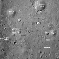
Solar System Cartographer Group: Members Posts: 10193 Joined: 5-April 05 From: Canada Member No.: 227 |
Here's a guide to the new names.
Phil
-------------------- ... because the Solar System ain't gonna map itself.
Also to be found posting similar content on https://mastodon.social/@PhilStooke Maps for download (free PD: https://upload.wikimedia.org/wikipedia/comm...Cartography.pdf NOTE: everything created by me which I post on UMSF is considered to be in the public domain (NOT CC, public domain) |
|
|
|
|
|
|
Nov 25 2014, 12:15 AM
Post
#53
|
||
|
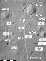
Solar System Cartographer Group: Members Posts: 10193 Joined: 5-April 05 From: Canada Member No.: 227 |
This map adds the names and updates the route to take the most recent maps into account. A reminder - I still don't know the exact dates of stops near the end of the route. The dates I give are only guesses.
Phil
-------------------- ... because the Solar System ain't gonna map itself.
Also to be found posting similar content on https://mastodon.social/@PhilStooke Maps for download (free PD: https://upload.wikimedia.org/wikipedia/comm...Cartography.pdf NOTE: everything created by me which I post on UMSF is considered to be in the public domain (NOT CC, public domain) |
|
|
|
|
|
|
Nov 25 2014, 05:17 PM
Post
#54
|
|
|
Senior Member Group: Members Posts: 1089 Joined: 19-February 05 From: Close to Meudon Observatory in France Member No.: 172 |
QUOTE (Phil Stooke @ Nov 25 2014, 01:15 AM) ...A reminder - I still don't know the exact dates of stops near the end of the route. The dates I give are only guesses. Phil Phil, anyway : this is a GREAT map ! Thanks, thanks so much for sharing this very nice work with us
|
|
|
|
|
Jan 12 2016, 06:41 PM
Post
#55
|
|||
|
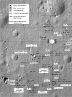
Solar System Cartographer Group: Members Posts: 10193 Joined: 5-April 05 From: Canada Member No.: 227 |
I am revising and extending my old Moon book, and just did some work on Chang'E 3. This and some recent publications allow me to revise the route map, and now I am confident I do have the dates correct... though there is still some uncertainty about whether some dates correspond to Beijing time or Universal Time. So here is probably the last update of this thread.
Phil
The Chinese names come mostly from a mission overview paper in Space Science Reviews: Li, C. et al, 2015. The Chang’e 3 Mission Overview. Space Science Reviews, v. 190, pp. 85-101. -------------------- ... because the Solar System ain't gonna map itself.
Also to be found posting similar content on https://mastodon.social/@PhilStooke Maps for download (free PD: https://upload.wikimedia.org/wikipedia/comm...Cartography.pdf NOTE: everything created by me which I post on UMSF is considered to be in the public domain (NOT CC, public domain) |
||
|
|
|
||
 |

|
Lo-Fi Version | Time is now: 18th June 2024 - 05:50 AM |
|
RULES AND GUIDELINES Please read the Forum Rules and Guidelines before posting. IMAGE COPYRIGHT |
OPINIONS AND MODERATION Opinions expressed on UnmannedSpaceflight.com are those of the individual posters and do not necessarily reflect the opinions of UnmannedSpaceflight.com or The Planetary Society. The all-volunteer UnmannedSpaceflight.com moderation team is wholly independent of The Planetary Society. The Planetary Society has no influence over decisions made by the UnmannedSpaceflight.com moderators. |
SUPPORT THE FORUM Unmannedspaceflight.com is funded by the Planetary Society. Please consider supporting our work and many other projects by donating to the Society or becoming a member. |
|