Finishing work in and around Seitah, sols 238-378 |

Finishing work in and around Seitah, sols 238-378 |
 Oct 21 2021, 06:50 AM Oct 21 2021, 06:50 AM
Post
#1
|
|
|
Solar System Cartographer  Group: Members Posts: 10186 Joined: 5-April 05 From: Canada Member No.: 227 |
It's time to start a new thread - this will cover the remaining work in Seitah and the drive back to the landing site.
Phil -------------------- ... because the Solar System ain't gonna map itself.
Also to be found posting similar content on https://mastodon.social/@PhilStooke Maps for download (free PD: https://upload.wikimedia.org/wikipedia/comm...Cartography.pdf NOTE: everything created by me which I post on UMSF is considered to be in the public domain (NOT CC, public domain) |
 |
 
|
 |
|
Oct 22 2021, 12:13 AM
Post
#2
|
||
|
Solar System Cartographer Group: Members Posts: 10186 Joined: 5-April 05 From: Canada Member No.: 227 |
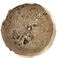
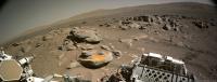
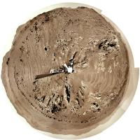
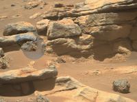
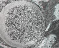
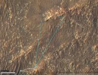
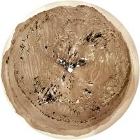
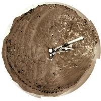
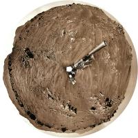
OK, a drive up to the outcrop on sol 238. Here is a circular view of the new location.
Phil
-------------------- ... because the Solar System ain't gonna map itself.
Also to be found posting similar content on https://mastodon.social/@PhilStooke Maps for download (free PD: https://upload.wikimedia.org/wikipedia/comm...Cartography.pdf NOTE: everything created by me which I post on UMSF is considered to be in the public domain (NOT CC, public domain) |
|
|
|
|
|
|
Oct 22 2021, 12:13 PM
Post
#3
|
||
 Member Group: Members Posts: 692 Joined: 9-May 21 From: Germany Member No.: 9017 |
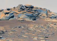
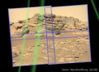
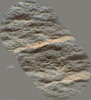
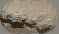
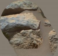
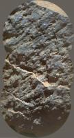
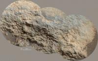
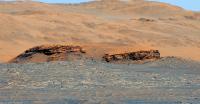
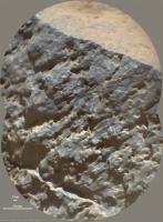
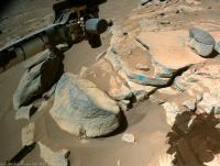
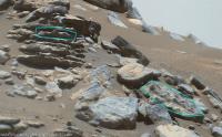
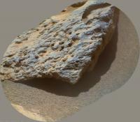
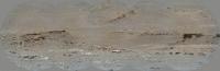
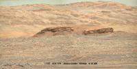
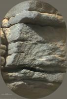
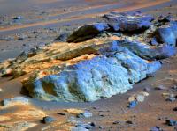
An outcrop of compact, layered rock with overlying vesicular rock fragments on sol 238.
Mastcam-Z left eye filter 0 (RGB), colors enhanced.
|
|
|
|
|
|
|
Oct 22 2021, 04:19 PM
Post
#4
|
|
|
Senior Member Group: Members Posts: 2998 Joined: 30-October 04 Member No.: 105 |
Tau, this stratigraphy is getting interesting.
Time to backtrack and try to intuit the bedding orientation. --Bill -------------------- |
|
|
|
|
Oct 22 2021, 10:16 PM
Post
#5
|
|
|
Senior Member Group: Members Posts: 1045 Joined: 17-February 09 Member No.: 4605 |
Perseverance had a pretty fair tilt when this was taken and these are probably as horizontal as the precious ridge.
|
|
|
|
|
Oct 23 2021, 12:46 AM
Post
#6
|
||
|
Solar System Cartographer Group: Members Posts: 10186 Joined: 5-April 05 From: Canada Member No.: 227 |
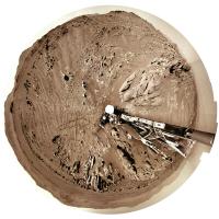
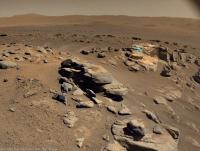
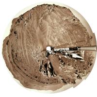
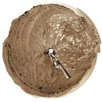
Sol 239, another drive... another circular panorama.
Phil
-------------------- ... because the Solar System ain't gonna map itself.
Also to be found posting similar content on https://mastodon.social/@PhilStooke Maps for download (free PD: https://upload.wikimedia.org/wikipedia/comm...Cartography.pdf NOTE: everything created by me which I post on UMSF is considered to be in the public domain (NOT CC, public domain) |
|
|
|
|
|
|
Oct 23 2021, 01:20 AM
Post
#7
|
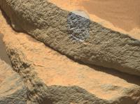
|
|
Senior Member Group: Members Posts: 1045 Joined: 17-February 09 Member No.: 4605 |
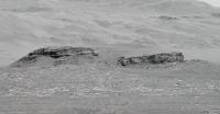
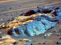
QUOTE (tau @ Oct 22 2021, 12:13 PM)  An outcrop of compact, layered rock with overlying vesicular rock fragments on sol 238. To me this looks more like honeycomb weathering of basaltic sandstone rather than vesicular basalt tau, but I stand to be corrected. |
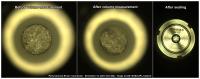
|
|
|
|
Oct 23 2021, 12:45 PM
Post
#8
|
|
|
Member Group: Members Posts: 692 Joined: 9-May 21 From: Germany Member No.: 9017 |
If the term "vesicular" implies a specific type of rock or origin of the rock, then I would rather refer to it as "spongeous appearance".
I would not rule out weathering as the reason of the small holes/cavities. |
|
|
|
|
Oct 23 2021, 07:18 PM
Post
#9
|
||||
|
Member Group: Members Posts: 692 Joined: 9-May 21 From: Germany Member No.: 9017 |
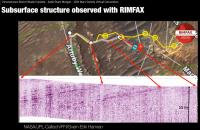
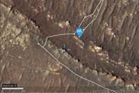
QUOTE (Bill Harris @ Oct 22 2021, 06:19 PM) Tau, this stratigraphy is getting interesting. Time to backtrack and try to intuit the bedding orientation. QUOTE (serpens @ Oct 23 2021, 12:16 AM) Perseverance had a pretty fair tilt when this was taken and these are probably as horizontal as the precious ridge. As to the bedding orientation, here is a sol 236 Navcam image with the sol 238 Mastcam-Z image as inset. If there is any tilt of the rover, it seems to be rather small. Navcam and Mastcam-Z are looking east-northeast. The layers are dipping to the right, i.e., towards the Artuby ridge. This is consistent with the Rimfax results in the screenshot below, which is from a presentation by Kathryn Stack Morgan. Thanks to cIclops for the link to this very interesting video! The part about Rimfax and Séítah layering begins after 21 minutes. Here is a direct link to this part. The field of view of the sol 238 Mastcam-Z image and the position of Perseverance on sol 239 are marked in the upper right section of a helicopter photo from sol 174.
EDIT: Corrected the compass direction that the Navcam and Mastcam-Z looked at. I had accidentaly typed west where I meant east. The correct direction is east-nordeast. |
|||
|
|
|
|||
|
Oct 23 2021, 07:31 PM
Post
#10
|
|
|
Senior Member Group: Members Posts: 2998 Joined: 30-October 04 Member No.: 105 |
I haven't had the chance to look at that video presentation yet.
The RIMFAX data fairly well corresponds to my general observations. In a general sense, the "beds are essentially flat-lying with a gentle regional dip to the southwest". Artuby ridge is stratigraphically the high point of this section of the traverse and we are headed along stratigraphically lower units. And Artuby is the youngest unit, and we are traversing along increasingly older units. Nice presentation of yours. --Bill -------------------- |
|
|
|
|
Oct 23 2021, 10:49 PM
Post
#11
|
||
|
Senior Member Group: Members Posts: 1045 Joined: 17-February 09 Member No.: 4605 |
Indeed, good one tau. The Rimfax trace doesn't show any real change in the angle of dip despite a 90 degree turn across the terrain, not that I have any skill whatsoever in interpreting such.
The reason I suspected an element of tilt was due to this Sol 238 Navcam image.
Attached thumbnail(s)
|
|
|
|
|
|
|
Oct 24 2021, 12:07 AM
Post
#12
|
|
|
Solar System Cartographer Group: Members Posts: 10186 Joined: 5-April 05 From: Canada Member No.: 227 |
That picture was taken at the sol 238 location, but Tau's image was from the sol 237 location, before the drive on sol 238.
Phil -------------------- ... because the Solar System ain't gonna map itself.
Also to be found posting similar content on https://mastodon.social/@PhilStooke Maps for download (free PD: https://upload.wikimedia.org/wikipedia/comm...Cartography.pdf NOTE: everything created by me which I post on UMSF is considered to be in the public domain (NOT CC, public domain) |
|
|
|
|
Oct 24 2021, 10:45 AM
Post
#13
|
||
 Senior Member Group: Members Posts: 2430 Joined: 30-January 13 From: Penang, Malaysia. Member No.: 6853 |
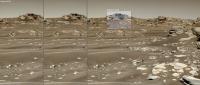
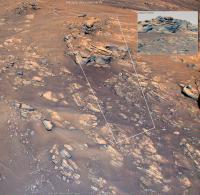
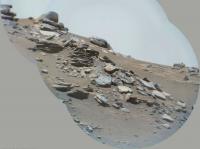
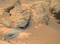
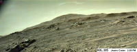
4x4 Navcam tile of Perseverance's post-drive workspace on sol 239.
Very roughly assembled and reduced to fit upload limits
|
|
|
|
|
|
|
Oct 24 2021, 04:41 PM
Post
#14
|
|||
|
Member Group: Members Posts: 692 Joined: 9-May 21 From: Germany Member No.: 9017 |
QUOTE (serpens @ Oct 23 2021, 12:16 AM) Perseverance had a pretty fair tilt when this was taken and these are probably as horizontal as the precious ridge. The tilt of the previously shown sol 238 Mastcam-Z picture can be estimated with the projection of the images onto a sphere provided online by marslife.org. The mast was tilted about 4° to the left (that's more than I presumed from the Navcam photos). When we apply the tilt to the picture, the layers are still tilted to the right (towards Artuby ridge) with an angle of about 7° to 8°. This is in accordance with the Rimfax results where we have a dip angle of about 12° towards Artuby ridge.
|
||
|
|
|
||
|
Oct 24 2021, 09:15 PM
Post
#15
|
|
|
Senior Member Group: Members Posts: 2998 Joined: 30-October 04 Member No.: 105 |
This site you noted, https://marslife.org/ , looks interesting and potentially useful. Let me dig around and find documentation on the site.
--Bill -------------------- |
|
|
|
|
Oct 25 2021, 12:08 AM
Post
#16
|
|
|
Senior Member Group: Members Posts: 1045 Joined: 17-February 09 Member No.: 4605 |
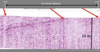
The dipping structure in the Rimfax trace seems to disappear at the third position Tau and it would be interesting to see subsequent results to determine if similar structure re-appears. The trace presentation seems to be truncated in the X axis which accentuates the angle of dip which if the trace were extended to agree with the 15 metre depth would be around 7 degrees.
|
|
|
|
|
Oct 25 2021, 05:19 PM
Post
#17
|
|||
|
Member Group: Members Posts: 692 Joined: 9-May 21 From: Germany Member No.: 9017 |
The Rimfax diagram has two small marks for sol 201 and sol 202.
In the Hirise map, the positions of sol 201 and sol 202 can be connected by a stright line ("as the crow flies") with a linear distance of about 43 m. This line is almost perpendicular to Artuby ridge. The ridge can be assumed to represent a strike line of the layers. When the Rimfax diagram between sol 201 and sol 202 is stretched horizontally according to the vertical scale, we get a dip angle of about 11° to 12°.
|
||
|
|
|
||
|
Oct 26 2021, 04:12 PM
Post
#18
|
||||
|
Member Group: Members Posts: 692 Joined: 9-May 21 From: Germany Member No.: 9017 |
Sol 242 SuperCam Remote Micro Imager with double context.
Grain-size measurement by stereoscopy gives an average grain diameter of about 1.3 mm
|
|||
|
|
|
|||
|
Nov 1 2021, 12:02 AM
Post
#19
|
||
|
Senior Member Group: Members Posts: 2430 Joined: 30-January 13 From: Penang, Malaysia. Member No.: 6853 |
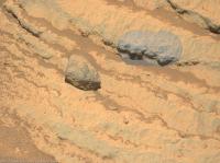
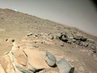
Roughly processed sol 248 end-of-drive 4 tile Navcam. The site index incremented which could indicate we are at, or very close to the next sample site.
|
|
|
|
|
|
|
Nov 1 2021, 03:15 AM
Post
#20
|
|
|
Solar System Cartographer Group: Members Posts: 10186 Joined: 5-April 05 From: Canada Member No.: 227 |
Yes, a move, but really just a turn in place (possibly involving a drive downslope, a turn and back upslope, but I only see the end result).
Phil -------------------- ... because the Solar System ain't gonna map itself.
Also to be found posting similar content on https://mastodon.social/@PhilStooke Maps for download (free PD: https://upload.wikimedia.org/wikipedia/comm...Cartography.pdf NOTE: everything created by me which I post on UMSF is considered to be in the public domain (NOT CC, public domain) |
|
|
|
|
Nov 1 2021, 08:54 AM
Post
#21
|
|
|
Senior Member Group: Members Posts: 2998 Joined: 30-October 04 Member No.: 105 |
QUOTE (PaulH51 @ Oct 31 2021, 07:02 PM) Roughly processed sol 248 end-of-drive 4 tile Navcam. The site index incremented which could indicate we are at, or very close to the next sample site. Plenty of interesting contacts here. Especially that (apparently) loose rock at the top with the dark basaltic (?) unit on top of the grey clastic (?) unit on top of the in-place units. --Bill -------------------- |
|
|
|
|
Nov 1 2021, 01:05 PM
Post
#22
|
||
|
Member Group: Members Posts: 692 Joined: 9-May 21 From: Germany Member No.: 9017 |
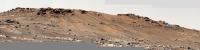
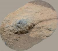
Kodiak behind Séítah as seen by the SuperCam Remote Micro-Imager on Sol 248
|
|
|
|
|
|
|
Nov 1 2021, 04:33 PM
Post
#23
|
||
|
Solar System Cartographer Group: Members Posts: 10186 Joined: 5-April 05 From: Canada Member No.: 227 |
That's a beautiful image of Kodiak. Thanks!
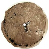
Here is a circular panorama for the current position. Phil
-------------------- ... because the Solar System ain't gonna map itself.
Also to be found posting similar content on https://mastodon.social/@PhilStooke Maps for download (free PD: https://upload.wikimedia.org/wikipedia/comm...Cartography.pdf NOTE: everything created by me which I post on UMSF is considered to be in the public domain (NOT CC, public domain) |
|
|
|
|
|
|
Nov 1 2021, 05:35 PM
Post
#24
|
|
|
Solar System Cartographer Group: Members Posts: 10186 Joined: 5-April 05 From: Canada Member No.: 227 |
Paul: "The site index incremented which could indicate we are at, or very close to the next sample site."
I was asked about site numbering, and i don't have specific information about Persererance, but this is a document for Curiosity which discusses sites.  MSL_Coordinate_Frames_Mar5_2013.pdf ( 343.63K )
Number of downloads: 373
MSL_Coordinate_Frames_Mar5_2013.pdf ( 343.63K )
Number of downloads: 373I expect the situation is the same for Perseverance. A new site number doesn't really suggest sampling is about to happen, though I expect it is. Phil -------------------- ... because the Solar System ain't gonna map itself.
Also to be found posting similar content on https://mastodon.social/@PhilStooke Maps for download (free PD: https://upload.wikimedia.org/wikipedia/comm...Cartography.pdf NOTE: everything created by me which I post on UMSF is considered to be in the public domain (NOT CC, public domain) |
|
|
|
|
Nov 1 2021, 06:38 PM
Post
#25
|
|
|
Founder Group: Chairman Posts: 14433 Joined: 8-February 04 Member No.: 1 |
The site incrementing is usually because the propagated error in attitude knowledge has reached a certain limit. It's usually based on cumulative IMU on time.
|
|
|
|
|
Nov 1 2021, 08:43 PM
Post
#26
|
||||
|
Member Group: Members Posts: 692 Joined: 9-May 21 From: Germany Member No.: 9017 |
Sol 247 SuperCam RMI with Mastcam-Z context and sol 147 Helicopter color camera context
|
|||
|
|
|
|||
|
Nov 5 2021, 05:01 PM
Post
#27
|
||||
|
Member Group: Members Posts: 692 Joined: 9-May 21 From: Germany Member No.: 9017 |
Sol 252 SuperCam RMI with Mastcam-Z and Navcam context
|
|||
|
|
|
|||
|
Nov 6 2021, 08:09 AM
Post
#28
|
|
|
Senior Member Group: Members Posts: 2430 Joined: 30-January 13 From: Penang, Malaysia. Member No.: 6853 |
|
|
|
|
|
Nov 6 2021, 01:27 PM
Post
#29
|
|||
|
Member Group: Members Posts: 692 Joined: 9-May 21 From: Germany Member No.: 9017 |
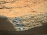
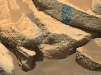
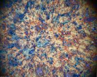
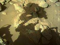
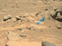
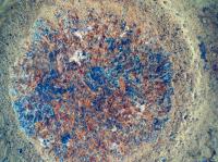
A sol 253 Sherloc Watson camera image with enhanced colors and an anaglyph of the abrasion target.
Could that small white triangle above the center of the abraded area be a lost part of the abrasion tool?
|
||
|
|
|
||
|
Nov 6 2021, 06:05 PM
Post
#30
|
||||
|
Member Group: Members Posts: 692 Joined: 9-May 21 From: Germany Member No.: 9017 |
Sol 253 SuperCam RMI with Mastcam-Z and Navcam context
|
|||
|
|
|
|||
|
Nov 6 2021, 09:43 PM
Post
#31
|
||
|
Senior Member Group: Members Posts: 2430 Joined: 30-January 13 From: Penang, Malaysia. Member No.: 6853 |
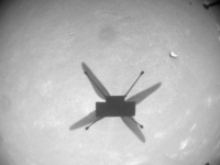
Mars Helicopter - November 6, 2021 (Sol 254) Flight 15 NavCam - 12:06 local time
|
|
|
|
|
|
|
Nov 8 2021, 02:50 PM
Post
#32
|
||
|
Senior Member Group: Members Posts: 1074 Joined: 21-September 07 From: Québec, Canada Member No.: 3908 |
Sol 254 LMastcam-Z:
|
|
|
|
|
|
|
Nov 8 2021, 07:44 PM
Post
#33
|
||||
|
Member Group: Members Posts: 692 Joined: 9-May 21 From: Germany Member No.: 9017 |
The sol 253 abrasion target in sol 255 Mastcam-Z images
1. Raw image left eye filter 0 (visible RGB) 2. Left eye filters 0 to 6 multispectral principal components 3. Right eye filter 0 (RGB) and infrared filters 1 to 6 multispectral principal components 1
|
|||
|
|
|
|||
|
Nov 10 2021, 06:40 PM
Post
#34
|
||
|
Member Group: Members Posts: 692 Joined: 9-May 21 From: Germany Member No.: 9017 |
The abraded surface in a combination of sol 257 images with SHERLOC Autofocus and Context Imager for detail and SHERLOC WATSON camera for enhanced color.
Do I see concentric zoning and lamellae in some crystals (I do not mean the visible effect of the abrading tool hammering), or are these just image artifacts or imagination ?
|
|
|
|
|
|
|
Nov 10 2021, 08:21 PM
Post
#35
|
|
|
Senior Member Group: Members Posts: 2998 Joined: 30-October 04 Member No.: 105 |
We do see zoning as well as lamellae in these mineral grains. I'm thinking that the zonation is due to weathering in a wet and oxygenated environment. These rocks are covered with a weathering crust and this abraded area is just beneath that zone.
--Bill -------------------- |
|
|
|
|
Nov 12 2021, 05:55 PM
Post
#36
|
||||
|
Member Group: Members Posts: 692 Joined: 9-May 21 From: Germany Member No.: 9017 |
Sol 256 SuperCam Remote Micro Imager with Mastcam-Z context and anaglyph
|
|||
|
|
|
|||
|
Nov 13 2021, 12:34 AM
Post
#37
|
|
|
Senior Member Group: Members Posts: 2998 Joined: 30-October 04 Member No.: 105 |
Percy hasn't covered much distance since leaving the Artuby ridge. But the Micro Imager shows consistent grain size, sorting, and angularity in several images. More important than the linear surface distance is the stratigraphic interval, which covers time as well as space. We don't know the deposition rates yet, so this time interval could be years, tens, or hundreds or thousands.
--Bill -------------------- |
|
|
|
|
Nov 13 2021, 06:37 PM
Post
#38
|
|
|
Solar System Cartographer Group: Members Posts: 10186 Joined: 5-April 05 From: Canada Member No.: 227 |
Since this is Mars, it could be hundreds of millions of years.
Phil -------------------- ... because the Solar System ain't gonna map itself.
Also to be found posting similar content on https://mastodon.social/@PhilStooke Maps for download (free PD: https://upload.wikimedia.org/wikipedia/comm...Cartography.pdf NOTE: everything created by me which I post on UMSF is considered to be in the public domain (NOT CC, public domain) |
|
|
|
|
Nov 14 2021, 04:56 PM
Post
#39
|
|||
|
Member Group: Members Posts: 692 Joined: 9-May 21 From: Germany Member No.: 9017 |
Sol 248 Mastcam-Z. Kodiak with enhanced colors and as anaglyph.
The stereoscopic effect is quite weak because of the large distances. The visible distant part of Séítah is about 1 km away, Kodiak 2 km, and the inner crater wall about 7 km and more.
|
||
|
|
|
||
|
Nov 15 2021, 11:30 AM
Post
#40
|
||||
|
Senior Member Group: Members Posts: 2430 Joined: 30-January 13 From: Penang, Malaysia. Member No.: 6853 |
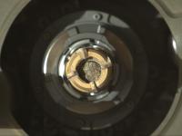
Latest sample from Jezero imaged in the rover's coring bit.
November 15, 2021 (Sol 262) Edit: Added L-Navcam of the hole Edit#2: roughly assembled raw 4-tile L-Navcam (MS-ICE) All jpg'ed to reduce server impact
|
|||
|
|
|
|||
|
Nov 15 2021, 09:42 PM
Post
#41
|
|
 Member Group: Members Posts: 815 Joined: 3-June 04 From: Brittany, France Member No.: 79 |
My take on the 4-tile NavCam Left mosaic.

-------------------- |
|
|
|
|
Nov 15 2021, 11:08 PM
Post
#42
|
||
|
Senior Member Group: Members Posts: 2430 Joined: 30-January 13 From: Penang, Malaysia. Member No.: 6853 |
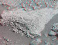
Sol 262 CacheCam shows the core is in at least two sections. The 2nd (later) image provides us a with a side-on view of the upper section of the core closest to the camera.
I'm assuming the upper section of the core rotated after the static probe was used at the Volume station to measure the size of the sample, and to ensure there was room to fit the seal. I'm sure geologists will enjoy this bonus side-on view of the split core and its grain structure.
|
|
|
|
|
|
|
Nov 18 2021, 11:16 AM
Post
#43
|
|||||
|
Member Group: Members Posts: 692 Joined: 9-May 21 From: Germany Member No.: 9017 |
Sol 255 SuperCam Remote Micro Imager with context images (2 Mastcam-Z sol 255, 1 Navcam sol 253), ordered by decreasing focal length
|
||||
|
|
|
||||
|
Nov 18 2021, 03:58 PM
Post
#44
|
|
 Senior Member Group: Members Posts: 1089 Joined: 19-February 05 From: Close to Meudon Observatory in France Member No.: 172 |
QUOTE (tau @ Nov 18 2021, 01:16 PM) Sol 255 SuperCam Remote Micro Imager with context images (2 Mastcam-Z sol 255, 1 Navcam sol 253), ordered by decreasing focal length Thanks a lot Tau for this superb work of yours  |
|
|
|
|
Nov 18 2021, 04:46 PM
Post
#45
|
||||
|
Member Group: Members Posts: 692 Joined: 9-May 21 From: Germany Member No.: 9017 |
Sol 265 SuperCam Remote Micro Imager with context images Mastcam-Z sol 241 and Navcam sol 248.
It took me a while to find appropriate context images.
|
|||
|
|
|
|||
|
Nov 18 2021, 06:25 PM
Post
#46
|
|
 Member Group: Members Posts: 701 Joined: 3-December 04 From: Boulder, Colorado, USA Member No.: 117 |
Looks like there may be some ripple structures preserved in the rock in that image.
John |
|
|
|
|
Nov 19 2021, 12:56 AM
Post
#47
|
|
 Member Group: Members Posts: 153 Joined: 8-February 04 From: Phoenix, AZ USA Member No.: 9 |
QUOTE (john_s @ Nov 18 2021, 01:25 PM) Looks like there may be some ripple structures preserved in the rock in that image. I see what you are talking about, at some of the bed boundaries. There is also a fallen piece that has a bedding plane exposed with what could be small 3D dunes or ripples (can't quite determine the scale). They both are not pleasingly preserved, at least from here, so we'll have to wait and see. We've been seeing distinct bed boundaries for a while, in several places along the traverse, at several stratigraphic intervals. None of them looked completely planar, but there were no obvious ripple forms either, let alone cross-stratification within the beds. After finally determining that the grain size was in the medium-coarse to granule range, that's not surprising. Maybe the grain size is smaller in these outcrops, and ripples and dunes could have formed during the flows. -------------------- Tim Demko
BioLink site |
|
|
|
|
Nov 19 2021, 08:23 PM
Post
#48
|
|
|
Member Group: Members Posts: 282 Joined: 18-June 04 Member No.: 84 |
QUOTE (john_s @ Nov 18 2021, 07:25 PM) Looks like there may be some ripple structures preserved in the rock in that image. John Which image are you referring to? |
|
|
|
|
Nov 19 2021, 08:46 PM
Post
#49
|
|
|
Member Group: Members Posts: 701 Joined: 3-December 04 From: Boulder, Colorado, USA Member No.: 117 |
This post. Specifically the wavy bedding planes left of center, and the funky-looking slab surface on the slope just lower right of center.
John |
|
|
|
|
Nov 20 2021, 12:59 PM
Post
#50
|
|
|
Member Group: Members Posts: 692 Joined: 9-May 21 From: Germany Member No.: 9017 |
|
|
|
|
|
Nov 20 2021, 08:10 PM
Post
#51
|
|||
|
Member Group: Members Posts: 692 Joined: 9-May 21 From: Germany Member No.: 9017 |
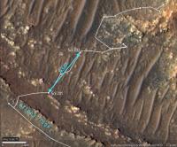
QUOTE (tdemko @ Nov 19 2021, 01:56 AM) I see what you are talking about, at some of the bed boundaries. There is also a fallen piece that has a bedding plane exposed with what could be small 3D dunes or ripples (can't quite determine the scale). . . . Regarding the scale, here is a sol 265 Mastcam-Z context panorama for the sol 265 SuperCam detail image (bluish rectangle to the right), and a HiRISE map of the panorama's field of view. The target taken by the SuperCam is circled on the map. It is almost exactly 200 m away from the rover. With some calculations it came out that the visible distance between the suspected ripple crests is about 9 to 10 cm in the SuperCam detail image (see previous post).
|
||
|
|
|
||
|
Nov 24 2021, 06:44 PM
Post
#52
|
|
|
Solar System Cartographer Group: Members Posts: 10186 Joined: 5-April 05 From: Canada Member No.: 227 |
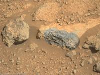
A second drill hole and sample just done at Brac.
https://mars.nasa.gov/mars2020-raw-images/p..._0LLJ01_800.jpg Phil -------------------- ... because the Solar System ain't gonna map itself.
Also to be found posting similar content on https://mastodon.social/@PhilStooke Maps for download (free PD: https://upload.wikimedia.org/wikipedia/comm...Cartography.pdf NOTE: everything created by me which I post on UMSF is considered to be in the public domain (NOT CC, public domain) |
|
|
|
|
Nov 24 2021, 08:50 PM
Post
#53
|
||
|
Member Group: Members Posts: 815 Joined: 3-June 04 From: Brittany, France Member No.: 79 |
Here is a picture of the second drill hole in Brac taken on sol 271.
-------------------- |
|
|
|
|
|
|
Nov 26 2021, 12:31 AM
Post
#54
|
||
|
Solar System Cartographer Group: Members Posts: 10186 Joined: 5-April 05 From: Canada Member No.: 227 |
I have collected and labelled images of the various sampling (and related activities) sites with the names as I know them so far. I don't yet have a name for the most recent sample hole. All images are oriented roughly north-up, not in raw image orientation.
Phil
-------------------- ... because the Solar System ain't gonna map itself.
Also to be found posting similar content on https://mastodon.social/@PhilStooke Maps for download (free PD: https://upload.wikimedia.org/wikipedia/comm...Cartography.pdf NOTE: everything created by me which I post on UMSF is considered to be in the public domain (NOT CC, public domain) |
|
|
|
|
|
|
Nov 26 2021, 05:00 PM
Post
#55
|
||
|
Senior Member Group: Members Posts: 1089 Joined: 19-February 05 From: Close to Meudon Observatory in France Member No.: 172 |
Sol 265 partial pan and also in 3D. Enjoy
|
|
|
|
|
|
|
Nov 26 2021, 05:03 PM
Post
#56
|
||
|
Senior Member Group: Members Posts: 1089 Joined: 19-February 05 From: Close to Meudon Observatory in France Member No.: 172 |
Because the distances between the foreground and background are big, take some time to let your eyes adapt 
|
|
|
|
|
|
|
Nov 27 2021, 01:46 AM
Post
#57
|
||
|
Senior Member Group: Members Posts: 2430 Joined: 30-January 13 From: Penang, Malaysia. Member No.: 6853 |
Sol 271: CacheCam 2-tile fusion stitch of sample number 5 in its tube prior to sealing, roughly assembled in MS-ICE (unprocessed other than the stitch)
|
|
|
|
|
|
|
Nov 27 2021, 07:23 AM
Post
#58
|
|||
|
Senior Member Group: Members Posts: 1089 Joined: 19-February 05 From: Close to Meudon Observatory in France Member No.: 172 |
Sol 248 of Perseverance's mission : more spectacular rocks to be seen... and also in 3D. Enjoy
|
||
|
|
|
||
|
Nov 28 2021, 05:22 PM
Post
#59
|
|||||
|
Member Group: Members Posts: 692 Joined: 9-May 21 From: Germany Member No.: 9017 |
Sol 274 SuperCam Remote Micro Imager with sol 274 and sol 265 Mastcam-Z context
|
||||
|
|
|
||||
|
Nov 29 2021, 02:18 PM
Post
#60
|
||
|
Senior Member Group: Members Posts: 1074 Joined: 21-September 07 From: Québec, Canada Member No.: 3908 |
Sol 275 Lmastcam-Z:
|
|
|
|
|
|
|
Nov 29 2021, 03:56 PM
Post
#61
|
|
|
Senior Member Group: Members Posts: 1089 Joined: 19-February 05 From: Close to Meudon Observatory in France Member No.: 172 |
QUOTE (charborob @ Nov 29 2021, 03:18 PM) Sol 275 Lmastcam-Z: What a nice mosaic! Thanks Robert to share this work with us |
|
|
|
|
Dec 1 2021, 08:15 AM
Post
#62
|
||||
|
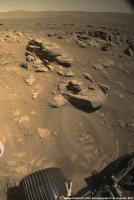
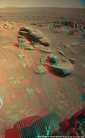
Senior Member Group: Members Posts: 1089 Joined: 19-February 05 From: Close to Meudon Observatory in France Member No.: 172 |
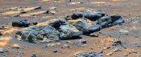
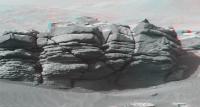
Sol 239 : here is one of the nicest views with gorgeous piles of rocks taken during the whole mission !
Also in 3D. Enjoy
|
|||
|
|
|
|||
|
Dec 1 2021, 04:30 PM
Post
#63
|
|
|
Member Group: Members Posts: 923 Joined: 10-November 15 Member No.: 7837 |
Here is my hasty effort ( avoid the extended sky! ) for Sol 275 MZR along with a 4k video on Youtube
     -------------------- |
|
|
|
|
Dec 1 2021, 06:08 PM
Post
#64
|
|
|
Solar System Cartographer Group: Members Posts: 10186 Joined: 5-April 05 From: Canada Member No.: 227 |
Very nice, Sean. Thanks!
Sol 278 - we just had a small move uphill, so the rover is now above Brac - behind it from the previous perspective. Phil -------------------- ... because the Solar System ain't gonna map itself.
Also to be found posting similar content on https://mastodon.social/@PhilStooke Maps for download (free PD: https://upload.wikimedia.org/wikipedia/comm...Cartography.pdf NOTE: everything created by me which I post on UMSF is considered to be in the public domain (NOT CC, public domain) |
|
|
|
|
Dec 1 2021, 07:29 PM
Post
#65
|
||
|
Solar System Cartographer Group: Members Posts: 10186 Joined: 5-April 05 From: Canada Member No.: 227 |
A quick circular panorama for sol 278.
Phil
-------------------- ... because the Solar System ain't gonna map itself.
Also to be found posting similar content on https://mastodon.social/@PhilStooke Maps for download (free PD: https://upload.wikimedia.org/wikipedia/comm...Cartography.pdf NOTE: everything created by me which I post on UMSF is considered to be in the public domain (NOT CC, public domain) |
|
|
|
|
|
|
Dec 3 2021, 05:33 PM
Post
#66
|
|||
|
Member Group: Members Posts: 692 Joined: 9-May 21 From: Germany Member No.: 9017 |
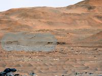
Sol 280 SuperCam Remote Micro Imager with sol 275 Mastcam-Z context showing the planned entrance to the delta remnants near a location on the crater floor called "Three Forks".
Will there be a continuation with some SuperCam RMI images on the right?
Edit: For extended context, check out the center of Sean's beautiful panorama in post #63. Second edit: "Planned entrance" refers to this image in the JPL Photojournal from January 2021, that was before landing. Plans may have changed meanwhile. |
||
|
|
|
||
|
Dec 3 2021, 08:09 PM
Post
#67
|
||
|
Solar System Cartographer Group: Members Posts: 10186 Joined: 5-April 05 From: Canada Member No.: 227 |
Sol 280, a circular view with lots of nice sandy ripples. This looks like the start of the return journey so it will lead to a new map.
Phil
-------------------- ... because the Solar System ain't gonna map itself.
Also to be found posting similar content on https://mastodon.social/@PhilStooke Maps for download (free PD: https://upload.wikimedia.org/wikipedia/comm...Cartography.pdf NOTE: everything created by me which I post on UMSF is considered to be in the public domain (NOT CC, public domain) |
|
|
|
|
|
|
Dec 5 2021, 08:43 AM
Post
#68
|
||
|
Solar System Cartographer Group: Members Posts: 10186 Joined: 5-April 05 From: Canada Member No.: 227 |
Another drive on sol 281 - here is a circular version of a panorama.
Phil
-------------------- ... because the Solar System ain't gonna map itself.
Also to be found posting similar content on https://mastodon.social/@PhilStooke Maps for download (free PD: https://upload.wikimedia.org/wikipedia/comm...Cartography.pdf NOTE: everything created by me which I post on UMSF is considered to be in the public domain (NOT CC, public domain) |
|
|
|
|
|
|
Dec 6 2021, 04:49 PM
Post
#69
|
|||||
|
Member Group: Members Posts: 692 Joined: 9-May 21 From: Germany Member No.: 9017 |
The planned entrance to the delta remnants in sol 280 Mastcam-Z images.
1. Raw image 2. Contrast enhanced 3. With simulated haze to emphasize the relief and the landscape units, and with distances from the rover position on sol 280 4. Left eye filters 1 to 6 multispectral principal components 1
For SuperCam details see also post #66. Edit: "Planned entrance" refers to this image in the JPL Photojournal from January 2021, that was before landing. Plans may have changed meanwhile. |
||||
|
|
|
||||
|
Dec 6 2021, 10:41 PM
Post
#70
|
||
|
Solar System Cartographer Group: Members Posts: 10186 Joined: 5-April 05 From: Canada Member No.: 227 |
Sol 283, we had a small move, a few m only, to the NE plus a rotation.
Phil EDIT: here's a circular panorama for sol 283.
-------------------- ... because the Solar System ain't gonna map itself.
Also to be found posting similar content on https://mastodon.social/@PhilStooke Maps for download (free PD: https://upload.wikimedia.org/wikipedia/comm...Cartography.pdf NOTE: everything created by me which I post on UMSF is considered to be in the public domain (NOT CC, public domain) |
|
|
|
|
|
|
Dec 7 2021, 02:51 AM
Post
#71
|
||
|
Member Group: Members Posts: 808 Joined: 10-October 06 From: Maynard Mass USA Member No.: 1241 |
SOL 275 9:15 AM
This is a part of the morning PAN (Kodiak) -- 4 image stitch Adaptive-Equalization
-------------------- CLA CLL
|
|
|
|
|
|
|
Dec 7 2021, 10:05 AM
Post
#72
|
|||
|
Member Group: Members Posts: 692 Joined: 9-May 21 From: Germany Member No.: 9017 |
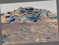
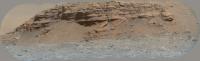
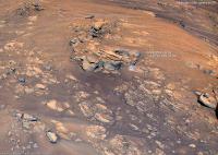
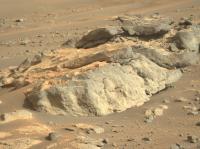
Layered outcrops in Séítah with Kodiak and the crater wall in the background on sol 282
1. Mastcam-Z right eye filter 0 (RGB), colors enhanced by principal components analysis 2. Anaglyph with impressive stereo effects (best seen on displays with wide gamut or extended color space) 1
|
||
|
|
|
||
|
Dec 8 2021, 03:08 AM
Post
#73
|
||
|
Member Group: Members Posts: 808 Joined: 10-October 06 From: Maynard Mass USA Member No.: 1241 |
SOL 283
We have clouds ...
-------------------- CLA CLL
|
|
|
|
|
|
|
Dec 8 2021, 08:54 AM
Post
#74
|
||
|
Senior Member Group: Members Posts: 1089 Joined: 19-February 05 From: Close to Meudon Observatory in France Member No.: 172 |
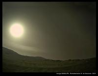
Sol 284: nice afternoon clouds. Enjoy
|
|
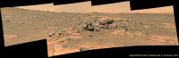
|
|
|
|
|
Dec 8 2021, 06:24 PM
Post
#75
|
||
|
Senior Member Group: Members Posts: 1089 Joined: 19-February 05 From: Close to Meudon Observatory in France Member No.: 172 |
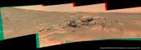
Sol 279.
I could not resist building this small panorama that shows such a romantic view with its scattered rock piles seen at late afternoon: this is the 'Mars' dreamed by Ray Bradbury. Also in 3D. Enjoy
|
|
|
|
|
|
|
Dec 8 2021, 06:26 PM
Post
#76
|
||
|
Senior Member Group: Members Posts: 1089 Joined: 19-February 05 From: Close to Meudon Observatory in France Member No.: 172 |
(cont.)
|
|
|
|
|
|
|
Dec 9 2021, 08:05 AM
Post
#77
|
||
|
Solar System Cartographer Group: Members Posts: 10186 Joined: 5-April 05 From: Canada Member No.: 227 |
Here is a circular panorama after the sol 285 drive. The next drive might just get out of Seitah, or to the bottom of the last slope.
Phil
-------------------- ... because the Solar System ain't gonna map itself.
Also to be found posting similar content on https://mastodon.social/@PhilStooke Maps for download (free PD: https://upload.wikimedia.org/wikipedia/comm...Cartography.pdf NOTE: everything created by me which I post on UMSF is considered to be in the public domain (NOT CC, public domain) |
|
|
|
|
|
|
Dec 9 2021, 09:44 PM
Post
#78
|
||
|
Senior Member Group: Members Posts: 2430 Joined: 30-January 13 From: Penang, Malaysia. Member No.: 6853 |
Welcome to site 9...
Sol 286: 4-tile Navcam (roughly assembled in MS-ICE) EDIT: Looks like a drive SSW by about 8 meters
|
|
|
|
|
|
|
Dec 9 2021, 11:08 PM
Post
#79
|
||
|
Member Group: Members Posts: 808 Joined: 10-October 06 From: Maynard Mass USA Member No.: 1241 |
Sol 285 -- 2:28 PM
Early afternoon clouds over the crater rim -- deltas in the foreground
-------------------- CLA CLL
|
|
|
|
|
|
|
Dec 12 2021, 12:24 AM
Post
#80
|
||
|
Senior Member Group: Members Posts: 2430 Joined: 30-January 13 From: Penang, Malaysia. Member No.: 6853 |
Looks like we may not be leaving Seitah as soon as I expected?
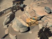
Sol 288 Hazcam (jpeg'd to save space) Drill press? or maybe abrasion preparation? Watch this space
|
|
|
|
|
|
|
Dec 12 2021, 03:25 AM
Post
#81
|
||
|
Senior Member Group: Members Posts: 1074 Joined: 21-September 07 From: Québec, Canada Member No.: 3908 |
Sol 288 LMastcam-Z:
|
|
|
|
|
|
|
Dec 12 2021, 05:37 AM
Post
#82
|
||
|
Member Group: Members Posts: 808 Joined: 10-October 06 From: Maynard Mass USA Member No.: 1241 |
Here is a subset of SOL88 Lmastcam-Z
-------------------- CLA CLL
|
|
|
|
|
|
|
Dec 12 2021, 04:46 PM
Post
#83
|
|
|
Senior Member Group: Members Posts: 2998 Joined: 30-October 04 Member No.: 105 |
Back at Artuby.
-------------------- |
|
|
|
|
Dec 12 2021, 07:15 PM
Post
#84
|
||||
|
Member Group: Members Posts: 692 Joined: 9-May 21 From: Germany Member No.: 9017 |
SuperCam Remote Micro Imager with Mastcam-Z and Navcam context on sol 286 at the edge of Séítah.
Stereophotometry gives an average grain diameter of about 1.3 mm
|
|||
|
|
|
|||
|
Dec 12 2021, 10:18 PM
Post
#85
|
|||
|
Member Group: Members Posts: 692 Joined: 9-May 21 From: Germany Member No.: 9017 |
A pretty fragile structure on sol 286.
Mastcam-Z anaglyph and left eye filter 0 (RGB) with enhanced colors.
|
||
|
|
|
||
|
Dec 13 2021, 06:37 AM
Post
#86
|
||
|
Solar System Cartographer Group: Members Posts: 10186 Joined: 5-April 05 From: Canada Member No.: 227 |
Circular panorama for sol 286.
Phil
-------------------- ... because the Solar System ain't gonna map itself.
Also to be found posting similar content on https://mastodon.social/@PhilStooke Maps for download (free PD: https://upload.wikimedia.org/wikipedia/comm...Cartography.pdf NOTE: everything created by me which I post on UMSF is considered to be in the public domain (NOT CC, public domain) |
|
|
|
|
|
|
Dec 14 2021, 02:03 AM
Post
#87
|
||
|
Member Group: Members Posts: 808 Joined: 10-October 06 From: Maynard Mass USA Member No.: 1241 |
Here is a local ridge PAN on SOL 289 -- 4:10 PM
-------------------- CLA CLL
|
|
|
|
|
|
|
Dec 14 2021, 04:27 PM
Post
#88
|
||
|
Senior Member Group: Members Posts: 1074 Joined: 21-September 07 From: Québec, Canada Member No.: 3908 |
Sol 290 LMastcam-Z:
|
|
|
|
|
|
|
Dec 14 2021, 05:10 PM
Post
#89
|
||||||
|
Member Group: Members Posts: 692 Joined: 9-May 21 From: Germany Member No.: 9017 |
Many interesting panoramas in these days and sols.
Here comes sol 290 SuperCam Remote Micro Imager with context (Mastcam-Z and Navcam sol 288, HiRISE) and Mastcam-Z anaglyph. The bright pebble in the SuperCam image to the right of center, enclosed between two layers, has a horizontal size of about 13 mm. The distance from the rover to the SuperCam target is 18 m.
|
|||||
|
|
|
|||||
|
Dec 14 2021, 09:42 PM
Post
#90
|
||||
|
Member Group: Members Posts: 692 Joined: 9-May 21 From: Germany Member No.: 9017 |
Sol 290 Mastcam-Z
1. Left eye filter 0 (RGB) raw image 2. Left eye filters 1 to 6 multispectral principal components 3. Right eye filters 0 to 6 multispectral principal components The small sharp-edged fragments with a slightly purple tint in the foreground are probably made of a different material than the other rocks in the image.
|
|||
|
|
|
|||
|
Dec 15 2021, 10:17 AM
Post
#91
|
||
|
Senior Member Group: Members Posts: 1089 Joined: 19-February 05 From: Close to Meudon Observatory in France Member No.: 172 |
The next poster to be seen on the wall of my office. Enjoy
|
|
|
|
|
|
|
Dec 15 2021, 12:18 PM
Post
#92
|
||
|
Junior Member Group: Members Posts: 91 Joined: 11-August 21 Member No.: 9072 |
With what instrument was this test performed? (sol 291)
 (full_res: https://mars.nasa.gov/mars2020-raw-images/p...4_0000LMJ01.png)
Attached thumbnail(s)
|
|
|
|
|
|
|
Dec 15 2021, 12:58 PM
Post
#93
|
|
|
Member Group: Members Posts: 913 Joined: 4-September 06 From: Boston Member No.: 1102 |
Deliberate wheel scrape? There seem to be parallel scratches that a wheel scrape would make. Just a guess.
-------------------- |
|
|
|
|
Dec 15 2021, 05:22 PM
Post
#94
|
||
|
Member Group: Members Posts: 692 Joined: 9-May 21 From: Germany Member No.: 9017 |
At first I had also thought of wheel scratches. But the lack of wheel marks around the rock and the timing looks like an abrasion attempt.
An uneven surface with rounded granules apparently prevented successful abrasion. Some of the granules were crushed.
Links to the original raw images: Mastcam-Z Front Right Hazard Avoidance Camera A SHERLOC WATSON camera Edit: Corrected annotation and raw image link to Front Right Hazard Avoidance Camera A |
|
|
|
|
|
|
Dec 15 2021, 05:40 PM
Post
#95
|
||
|
Member Group: Members Posts: 692 Joined: 9-May 21 From: Germany Member No.: 9017 |
Sol 291 SHERLOC WATSON camera
A very elongated crystal (length/width ratio 12:1 or more), or something else?
|
|
|
|
|
|
|
Dec 16 2021, 02:31 AM
Post
#96
|
||
|
Member Group: Members Posts: 808 Joined: 10-October 06 From: Maynard Mass USA Member No.: 1241 |
SOL 289
My DD detector couldn't find any DDs in this sequence but it kept lighting up the sky - Clouds 2:53 PM to 3:14 PM (~21 minutes) Chopped out the foreground (faint) Clouds in motion:
-------------------- CLA CLL
|
|
|
|
|
|
|
Dec 16 2021, 05:05 AM
Post
#97
|
|
|
Junior Member Group: Members Posts: 91 Joined: 11-August 21 Member No.: 9072 |
Meanwhile on December 15 NASA published unusually large set of materials in the 'News' section (six or more?) among which the most encouraging (IMHO) is this one named «NASAs Perseverance Mars Rover Makes Surprising Discoveries». The article tells about the unexpected results of the 2-day intensive usage of RIMFAX at the entry of Seitah-S, just after crossing Artuby ridge on sol 200.
.png/800px-RIMFAX_radargram_at_the_entry_of_South_Seitah_(PIA25025).png) |
|
|
|
|
Dec 16 2021, 01:23 PM
Post
#98
|
||
|
Member Group: Members Posts: 692 Joined: 9-May 21 From: Germany Member No.: 9017 |
QUOTE (tau @ Dec 15 2021, 06:22 PM) . . . An uneven surface with rounded granules apparently prevented successful abrasion. Some of the granules were crushed. . . . I was wrong with the crushed rounded granules. Obviously, these are fragments of the partially abraded very uneven surface of the rock, as an animated comparison before (sol 287) and after abrasion attempt (sol 291) shows.
|
|
|
|
|
|
|
Dec 16 2021, 02:26 PM
Post
#99
|
||
|
Member Group: Members Posts: 692 Joined: 9-May 21 From: Germany Member No.: 9017 |
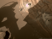
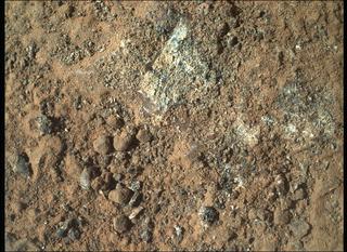
Sol 292 SHERLOC WATSON camera image (with enhanced colors) of a successful abrasion
|
|
|
|
|
|
|
Dec 16 2021, 03:42 PM
Post
#100
|
|
|
Senior Member Group: Members Posts: 2998 Joined: 30-October 04 Member No.: 105 |
-------------------- |
|
|
|
 |

|
Lo-Fi Version | Time is now: 6th June 2024 - 07:43 AM |
|
RULES AND GUIDELINES Please read the Forum Rules and Guidelines before posting. IMAGE COPYRIGHT |
OPINIONS AND MODERATION Opinions expressed on UnmannedSpaceflight.com are those of the individual posters and do not necessarily reflect the opinions of UnmannedSpaceflight.com or The Planetary Society. The all-volunteer UnmannedSpaceflight.com moderation team is wholly independent of The Planetary Society. The Planetary Society has no influence over decisions made by the UnmannedSpaceflight.com moderators. |
SUPPORT THE FORUM Unmannedspaceflight.com is funded by the Planetary Society. Please consider supporting our work and many other projects by donating to the Society or becoming a member. |
|