SMART-1 impact, September 2006 |

SMART-1 impact, September 2006 |
 Mar 16 2006, 05:26 PM Mar 16 2006, 05:26 PM
Post
#1
|
||
|
Solar System Cartographer  Group: Members Posts: 10196 Joined: 5-April 05 From: Canada Member No.: 227 |
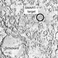
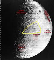
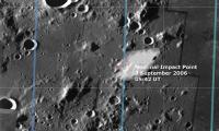
Emily posted a very nice article in her blog on the SMART-1 lunar impact in September this year. Here's a map of the targeted point:
But as Emily explained, the actual point may be off because of uncertainties about topography. I'm starting this thread to have a place for news and opinions on it, and - I really hope - maybe some observations at the time from any amateur astronomers out there. This event will be the last event to make it into my atlas. I've left a space for it, and I will make the final maps and fit them in, and then send the stuff off to the publisher. Phil -------------------- ... because the Solar System ain't gonna map itself.
Also to be found posting similar content on https://mastodon.social/@PhilStooke Maps for download (free PD: https://upload.wikimedia.org/wikipedia/comm...Cartography.pdf NOTE: everything created by me which I post on UMSF is considered to be in the public domain (NOT CC, public domain) |
|
 |
 
|
|
 |
|
Mar 16 2006, 08:41 PM
Post
#2
|
|
|
Senior Member Group: Members Posts: 2454 Joined: 8-July 05 From: NGC 5907 Member No.: 430 |
The March 16 edition of LPOD has an image of the SMART-1
impact region from Lunar Orbiter 4: http://www.lpod.org/?m=20060316 Interesting quote: "The good news is that SMART-1 has captured thousands of images of the Moon; the bad news is that because of the daily pressures of flying the mission the team will not have time to start archiving the images and release then until after the impact. Apparently many of the images have not been looked at by anyone!" -------------------- "After having some business dealings with men, I am occasionally chagrined,
and feel as if I had done some wrong, and it is hard to forget the ugly circumstance. I see that such intercourse long continued would make one thoroughly prosaic, hard, and coarse. But the longest intercourse with Nature, though in her rudest moods, does not thus harden and make coarse. A hard, sensible man whom we liken to a rock is indeed much harder than a rock. From hard, coarse, insensible men with whom I have no sympathy, I go to commune with the rocks, whose hearts are comparatively soft." - Henry David Thoreau, November 15, 1853 |
|
|
|
| Guest_AlexBlackwell_* |
Mar 16 2006, 08:50 PM
Post
#3
|
|
Guests |
QUOTE (ljk4-1 @ Mar 16 2006, 08:41 PM)  Interesting quote: "The good news is that SMART-1 has captured thousands of images of the Moon; the bad news is that because of the daily pressures of flying the mission the team will not have time to start archiving the images and release then until after the impact. Apparently many of the images have not been looked at by anyone!" Now, why doesn't that excuse work for, say, MSSS? Well, I guess SMART-1 doesn't have a "People's Camera" installed. 
|
|
|
|
|
Mar 16 2006, 09:05 PM
Post
#4
|
|
 Senior Member Group: Members Posts: 2488 Joined: 17-April 05 From: Glasgow, Scotland, UK Member No.: 239 |
QUOTE (ljk4-1 @ Mar 16 2006, 08:41 PM) Interesting quote: "The good news is that SMART-1 has captured thousands of images of the Moon; the bad news is that because of the daily pressures of flying the mission the team will not have time to start archiving the images and release then until after the impact. Apparently many of the images have not been looked at by anyone!" Pah! We'd have looked at them if they'd let us... In the famous words of the Eurovision Song Contest: ESA - Nil Points! Bob Shaw -------------------- Remember: Time Flies like the wind - but Fruit Flies like bananas!
|
|
|
|
|
Mar 16 2006, 09:06 PM
Post
#5
|
|
|
Founder Group: Chairman Posts: 14433 Joined: 8-February 04 Member No.: 1 |
Somehow, they get away with that excuse across the whole of ESA.
Doug |
|
|
|
|
Mar 16 2006, 09:07 PM
Post
#6
|
|
 Member Group: Members Posts: 510 Joined: 17-March 05 From: Southeast Michigan Member No.: 209 |
SMART-1 @ Home?
-------------------- --O'Dave
|
|
|
|
|
Mar 17 2006, 12:35 AM
Post
#7
|
|
 Dublin Correspondent Group: Admin Posts: 1799 Joined: 28-March 05 From: Celbridge, Ireland Member No.: 220 |
QUOTE (djellison @ Mar 16 2006, 09:06 PM) Somehow, they get away with that excuse across the whole of ESA. As a taxpayer who funds an admittedly minuscle component of this I am embarassed. The science is good and theadministration is defensible but the public outreach is abysmal. Oh well - time to ping my MEP yet again. |
|
|
|
|
Mar 17 2006, 08:34 AM
Post
#8
|
|
|
Founder Group: Chairman Posts: 14433 Joined: 8-February 04 Member No.: 1 |
What we need is Esawatch - I'm not a Cowing fan, but at least he asks the awkward questions from time to time.
Doug |
|
|
|
| Guest_AlexBlackwell_* |
Mar 17 2006, 05:13 PM
Post
#9
|
|
Guests |
QUOTE (djellison @ Mar 17 2006, 08:34 AM) What we need is Esawatch - I'm not a Cowing fan, but at least he asks the awkward questions from time to time. Do you really think an "ESAWatch" would work in Europe, given that U.S. "democracy" materially differs from European "democracy"? We (the U.S.) have our faults, as Europeans are more than willing to point out, but there are some ideas that work here that, in my opinion, wouldn't be easily transplantable to Europe. That said, I would love to see someone give ESA a dose of the "Cowing treatment," even if only for the sake of Schadenfreude. |
|
|
|
|
Mar 22 2006, 04:03 AM
Post
#10
|
|
|
Junior Member Group: Members Posts: 94 Joined: 22-March 06 Member No.: 722 |
I'm not optimistic about the results; I'm no expert, but has *any* impacting spacecraft or spent booster on the Moon generated a confirmed flash or ejecta sighting from Earth?
-------------------- Mayor: Er, Master Betty, what is the Evil Council's plan?
Master Betty: Nyah. Haha. It is EVIL, it is so EVIL. It is a bad, bad plan, which will hurt many... people... who are good. I think it's great that it's so bad. -Kung Pow: Enter the Fist |
|
|
|
|
Mar 22 2006, 04:27 AM
Post
#11
|
|
|
Solar System Cartographer Group: Members Posts: 10196 Joined: 5-April 05 From: Canada Member No.: 227 |
A very good question.
There is general agreement, I believe, that the Hiten impact on 10 April 1993 was visible, in fact imaged in IR (Google will lead you to the image). Like SMART-1 it was in darkness near the terminator on the near side. There were poorly documented reports that Luna 2's impact was observed (Sky & Tel. Nov 1960 p. 265). Similarly Luna 5's upper stage rocket (New Scientist, soon after impact, but I don't have the reference yet), and Luna 7 (unpublished MSC internal report in LPI library). Most western observers discounted these reports, and strenuous efforts to view the Ranger impacts came to nothing. But modern CCD and IR imaging should do much better. I personally have little doubt that SMART-1 is at the very least worth making an effort to see, and in fact will probably be imaged. Phil -------------------- ... because the Solar System ain't gonna map itself.
Also to be found posting similar content on https://mastodon.social/@PhilStooke Maps for download (free PD: https://upload.wikimedia.org/wikipedia/comm...Cartography.pdf NOTE: everything created by me which I post on UMSF is considered to be in the public domain (NOT CC, public domain) |
|
|
|
|
Mar 22 2006, 12:37 PM
Post
#12
|
|
|
Senior Member Group: Members Posts: 2454 Joined: 8-July 05 From: NGC 5907 Member No.: 430 |
QUOTE (Phil Stooke @ Mar 21 2006, 11:27 PM) A very good question. There is general agreement, I believe, that the Hiten impact on 10 April 1993 was visible, in fact imaged in IR (Google will lead you to the image). Like SMART-1 it was in darkness near the terminator on the near side. There were poorly documented reports that Luna 2's impact was observed (Sky & Tel. Nov 1960 p. 265). Similarly Luna 5's upper stage rocket (New Scientist, soon after impact, but I don't have the reference yet), and Luna 7 (unpublished MSC internal report in LPI library). Most western observers discounted these reports, and strenuous efforts to view the Ranger impacts came to nothing. But modern CCD and IR imaging should do much better. I personally have little doubt that SMART-1 is at the very least worth making an effort to see, and in fact will probably be imaged. Phil Dust cloud produced by Luna-5 impacting the lunar surface: http://ntrs.nasa.gov/archive/nasa/casi.ntr..._1979073878.pdf -------------------- "After having some business dealings with men, I am occasionally chagrined,
and feel as if I had done some wrong, and it is hard to forget the ugly circumstance. I see that such intercourse long continued would make one thoroughly prosaic, hard, and coarse. But the longest intercourse with Nature, though in her rudest moods, does not thus harden and make coarse. A hard, sensible man whom we liken to a rock is indeed much harder than a rock. From hard, coarse, insensible men with whom I have no sympathy, I go to commune with the rocks, whose hearts are comparatively soft." - Henry David Thoreau, November 15, 1853 |
|
|
|
|
Mar 24 2006, 05:10 AM
Post
#13
|
|
|
Junior Member Group: Members Posts: 94 Joined: 22-March 06 Member No.: 722 |
Thanks for the answers, people.
-------------------- Mayor: Er, Master Betty, what is the Evil Council's plan?
Master Betty: Nyah. Haha. It is EVIL, it is so EVIL. It is a bad, bad plan, which will hurt many... people... who are good. I think it's great that it's so bad. -Kung Pow: Enter the Fist |
|
|
|
|
Mar 24 2006, 04:44 PM
Post
#14
|
|
|
Solar System Cartographer Group: Members Posts: 10196 Joined: 5-April 05 From: Canada Member No.: 227 |
Very useful new report on the impact:
http://sci.esa.int/science-e/www/object/in...objectid=38988# Phil -------------------- ... because the Solar System ain't gonna map itself.
Also to be found posting similar content on https://mastodon.social/@PhilStooke Maps for download (free PD: https://upload.wikimedia.org/wikipedia/comm...Cartography.pdf NOTE: everything created by me which I post on UMSF is considered to be in the public domain (NOT CC, public domain) |
|
|
|
|
Mar 24 2006, 07:15 PM
Post
#15
|
|
|
Member Group: Members Posts: 624 Joined: 10-August 05 Member No.: 460 |
QUOTE (Bob Shaw @ Mar 16 2006, 02:05 PM) Pah! We'd have looked at them if they'd let us... In the famous words of the Eurovision Song Contest: ESA - Nil Points! Bob Shaw I wonder if the lens cap is off... 
|
|
|
|
|
Mar 26 2006, 03:54 PM
Post
#16
|
||
|
Solar System Cartographer Group: Members Posts: 10196 Joined: 5-April 05 From: Canada Member No.: 227 |
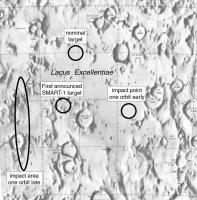
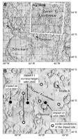
This map shows the target locations from the report just referred to. The original point may have been a statement of the nominal perilune rather than the actual impact point, misquoted in the press.
I'm just plotting coordinates on the old LAC chart. The points might be a bit off because of improved selenodetic control since the 60s. Phil
-------------------- ... because the Solar System ain't gonna map itself.
Also to be found posting similar content on https://mastodon.social/@PhilStooke Maps for download (free PD: https://upload.wikimedia.org/wikipedia/comm...Cartography.pdf NOTE: everything created by me which I post on UMSF is considered to be in the public domain (NOT CC, public domain) |
|
|
|
|
|
|
Mar 26 2006, 03:57 PM
Post
#17
|
|
 Senior Member Group: Members Posts: 3419 Joined: 9-February 04 From: Minneapolis, MN, USA Member No.: 15 |
So, like, they're gonna crash it into, like, Lake Excellent, dude?
Excellent!!!! ((insert bad air guitar riff here)) -the Other S. Doug, Esq. -------------------- The trouble ain't that there is too many fools, but that the lightning ain't distributed right. -Mark Twain
|
|
|
|
|
Mar 26 2006, 04:37 PM
Post
#18
|
|
|
Solar System Cartographer Group: Members Posts: 10196 Joined: 5-April 05 From: Canada Member No.: 227 |
I prefer a Mr Burns-style "Eeeeexcellent!"
Phil -------------------- ... because the Solar System ain't gonna map itself.
Also to be found posting similar content on https://mastodon.social/@PhilStooke Maps for download (free PD: https://upload.wikimedia.org/wikipedia/comm...Cartography.pdf NOTE: everything created by me which I post on UMSF is considered to be in the public domain (NOT CC, public domain) |
|
|
|
|
Mar 26 2006, 05:22 PM
Post
#19
|
||
|
Senior Member Group: Members Posts: 1636 Joined: 9-May 05 From: Lima, Peru Member No.: 385 |
QUOTE (Phil Stooke @ Mar 26 2006, 10:54 AM) This map shows the target locations from the report just referred to. The original point may have been a statement of the nominal perilune rather than the actual impact point, misquoted in the press. I'm just plotting coordinates on the old LAC chart. The points might be a bit off because of improved selenodetic control since the 60s. Phil
Shall anyone let us know the impact location in the Moon longitudinal and latitud's coordinates. I am not able to ubicate the Lacus Excelentia, forgive me, into an excellent lake! Rodolfo |
|
|
|
|
|
|
Mar 26 2006, 05:35 PM
Post
#20
|
|
|
Dublin Correspondent Group: Admin Posts: 1799 Joined: 28-March 05 From: Celbridge, Ireland Member No.: 220 |
QUOTE (RNeuhaus @ Mar 26 2006, 05:22 PM) Shall anyone let us know the impact location in the Moon longitudinal and latitud's coordinates. I am not able to ubicate the Lacus Excelentia, forgive me, into an excellent lake! Can't give you lat\lon but this puts it in context, Clausius is on the upper left. Looking at the whole moon it is slightly above and to the left of Tycho (the bright crater with very prominent ejecta rays in the southern hemisphere). |
|
|
|
|
Jun 23 2006, 09:03 PM
Post
#21
|
|
 Administrator Group: Admin Posts: 5172 Joined: 4-August 05 From: Pasadena, CA, USA, Earth Member No.: 454 |
ESA press release today:
SMART-1 manoeuvres prepare for mission end Looks like they're getting ready for the ending. I was wondering if anybody who knows more about lunar geography than I do could take a look at the unfortunately rather low-quality illustration of the impact site in that story and tell me if it looks like the same location as the one posted here previously. --Emily -------------------- My website - My Patreon - @elakdawalla on Twitter - Please support unmannedspaceflight.com by donating here.
|
|
|
|
|
Jun 23 2006, 09:19 PM
Post
#22
|
|
 Member Group: Members Posts: 370 Joined: 12-September 05 From: France Member No.: 495 |
Final operational report for the SMART-1 mission.
http://sci.esa.int/science-e/www/object/in...fobjectid=39395 |
|
|
|
|
Jun 25 2006, 10:42 PM
Post
#23
|
|
|
Junior Member Group: Members Posts: 81 Joined: 19-April 05 Member No.: 256 |
QUOTE (elakdawalla @ Jun 23 2006, 05:03 PM) ESA press release today: SMART-1 manoeuvres prepare for mission end That was an interesting article. The following paragraph got my attention. QUOTE The off-loading consists of braking a set of spinning wheels inside the spacecraft, which has the effect of transferring angular momentum from the wheels to the spacecraft and hence changing its velocity. I thought all you could do with reaction wheels is change spin and orientation, I didn't realize you could change velocity as well. Does that only work while in a gravity field or can that work in free space also? |
|
|
|
|
Jun 25 2006, 11:29 PM
Post
#24
|
|
|
Senior Member Group: Members Posts: 2488 Joined: 17-April 05 From: Glasgow, Scotland, UK Member No.: 239 |
QUOTE (garybeau @ Jun 25 2006, 11:42 PM) I thought all you could do with reaction wheels is change spin and orientation, I didn't realize you could change velocity as well. Does that only work while in a gravity field or can that work in free space also? Gary: I read that, and pondered also. I think the key was in the concurrent mention of attitude-control jet firings - I have the impression that they were 'hanging' the vehicle on the reaction wheels and firing the jets to create a force applied in the appropriate direction (the RCS jets wouldn't be balanced through the vehicle CG the way that the ion drive would be). It's all down to vectors... ...and the article could have been clearer! Bob Shaw -------------------- Remember: Time Flies like the wind - but Fruit Flies like bananas!
|
|
|
|
|
Jun 29 2006, 02:29 AM
Post
#25
|
|
|
Senior Member Group: Members Posts: 1870 Joined: 20-February 05 Member No.: 174 |
It's "nice" but not always "necessary" to have balanced attitude control jets, with two jets on opposite sides of a spacecraft's center-of-gravity firing in perfect opposition to rotate the spacecraft without any change in velocity. For a spacecraft doing fine attitude and translational maneuvers in close proximity to another spacecraft, like an Apollo rendezvouis and docking, yes, it's necessary, but often, it's not.
That, of course, is what killed Mars Climate Orbiter. The spacecraft was assymetrical, with one solar panel, and offloaded solar light pressure which slowly spun up the momentum wheels with weekly attitude thruster firings. The firings also imparted a small velocity change on the spacecraft that needed to be included in trajectory calculations. It was.. in the wrong units (english vs metric) throwing off the trajectory models in a particularly insidious way. |
|
|
|
| Guest_AlexBlackwell_* |
Aug 4 2006, 08:12 PM
Post
#26
|
|
Guests |
|
|
|
|
|
Aug 4 2006, 10:59 PM
Post
#27
|
|
|
Junior Member Group: Members Posts: 59 Joined: 25-December 05 From: Stevens Point, Wisconsin, USA Member No.: 619 |
Any harm for the Moon?
Nearly 50 years ago, in 1959, the Russian Luna-2 spacecraft was the first man-made object to hit the Moon. Since then many others have done the same, without any noticeable harm, and SMART-1s impact will be softer than that of any man-made impactor up till now. ... The crater made by SMART-1 will be 3 to 10 metres wide and perhaps a metre deep. The Moon already has 100 000 craters that are more than four kilometres wide, and every day several small meteoroids make craters as big as SMART-1s. Every chemical element present on SMART-1 and in its equipment exists naturally on the Moon. For instance aluminium and iron are very common. Hydrogen, carbon and nitrogen are much scarcer on the Moon, but they arrive naturally onto the surface from the solar wind and from the impacts of icy fragments of comets, which contain many elements. From this point of view, one can think of SMART-1 as an artificial comet. Furthermore, the little hydrazine left in the SMART-1 thrusters will burn immediately at impact. ...Interesting (and a bit silly if not creepy) that ESA took pains to explain that Smart-1s crash would have a minimal impact on the moon. I suppose they know their audience well and presume them to be extraordinarily green and caring about our fragile little satellite... |
|
|
|
|
Aug 4 2006, 11:49 PM
Post
#28
|
|
|
Senior Member Group: Members Posts: 2454 Joined: 8-July 05 From: NGC 5907 Member No.: 430 |
QUOTE (rogelio @ Aug 4 2006, 06:59 PM) ...Interesting (and a bit silly if not creepy) that ESA took pains to explain that Smart-1s crash would have a minimal impact on the moon. I suppose they know their audience well and presume them to be extraordinarily green and caring about our fragile little satellite... Certain Native American groups were upset to learn that Lunar Prospector contained the ashes of Gene Shoemaker when it crashed on the Moon in 1998, as they consider our nearest celestial neighbor to be sacred. Muslims also consider the Moon to be important to their faith. -------------------- "After having some business dealings with men, I am occasionally chagrined,
and feel as if I had done some wrong, and it is hard to forget the ugly circumstance. I see that such intercourse long continued would make one thoroughly prosaic, hard, and coarse. But the longest intercourse with Nature, though in her rudest moods, does not thus harden and make coarse. A hard, sensible man whom we liken to a rock is indeed much harder than a rock. From hard, coarse, insensible men with whom I have no sympathy, I go to commune with the rocks, whose hearts are comparatively soft." - Henry David Thoreau, November 15, 1853 |
|
|
|
| Guest_DonPMitchell_* |
Aug 6 2006, 06:44 PM
Post
#29
|
|
Guests |
James Oberg had an article some time ago about radical-Islamic objection to space exploration. There is a strong embracing of the Apollo hoax theories too. I guess the greens also object to space exploration, but usually on the grounds of using petroleum in rockets. And of course, if there is even a small RTG in a space probe, some people go nuts.
But remember that Muslims have made important contributions to space. Farouk El-Bas, for example, is a highly honored scientist in the US program. Radicalism isn't about Islam or Christianity or ecology. It is just ambitious people searching for political opportunities. If you are curious about some theory, read The True Believer by the philosopher, Eric Hoffer. Oh, my personal favorite crank political protest -- some people objected to NASA's Deep Impact mission, claiming that if the orbit of the comet was perturbed, it might collide with the Earth someday. :-) |
|
|
|
|
Aug 7 2006, 03:48 PM
Post
#30
|
|
 Interplanetary Dumpster Diver Group: Admin Posts: 4404 Joined: 17-February 04 From: Powell, TN Member No.: 33 |
QUOTE (DonPMitchell @ Aug 6 2006, 06:44 PM) James Oberg had an article some time ago about radical-Islamic objection to space exploration. There is a strong embracing of the Apollo hoax theories too. I guess the greens also object to space exploration, but usually on the grounds of using petroleum in rockets. And of course, if there is even a small RTG in a space probe, some people go nuts. I am assuming you mean plutonium
-------------------- |
|
|
|
|
Aug 10 2006, 03:11 PM
Post
#31
|
|
|
Senior Member Group: Members Posts: 2454 Joined: 8-July 05 From: NGC 5907 Member No.: 430 |
Lunar research opportunity
As many of you are aware, the ESA's SMART-1 lunar probe is scheduled to spiral down over the next three weeks, culminating in its impacting the Lunar surface on 3 September 2006. During its descent through the Moon's tenuous atmosphere, our colleague Claudio Maccone has proposed that as many of us as possible monitor its S-band and X-band beacons, to analyze the nature of the Lunar atmosphere through sounding measurements. He has secured time on the 32 metre VLBI antenna in Medicina to support these measurements. I know several of you have been doing Deep Space Network monitoring - now is your chance to make a significant amateur contribution to science. Claudio's research proposal to the Istituto di Radioastronomia appears (in English) at: http://www.setileague.org/articles/maccone.pdf Please take a look, and contact Claudio at the email address (clmaccon@libero.it) with cc to me, if you are able to participate in this important experiment. Thanks. If any of you are in touch with other amateur groups (SARA, ERAC, AMSAT, etc.) that may be interested in monitoring SMART-1, please feel free to cross-post this email to their various Lists. -- H. Paul Shuch, Ph.D. Executive Director Emeritus, The SETI League, Inc. http://www.setileague.org n6tx@setileague.org -------------------- "After having some business dealings with men, I am occasionally chagrined,
and feel as if I had done some wrong, and it is hard to forget the ugly circumstance. I see that such intercourse long continued would make one thoroughly prosaic, hard, and coarse. But the longest intercourse with Nature, though in her rudest moods, does not thus harden and make coarse. A hard, sensible man whom we liken to a rock is indeed much harder than a rock. From hard, coarse, insensible men with whom I have no sympathy, I go to commune with the rocks, whose hearts are comparatively soft." - Henry David Thoreau, November 15, 1853 |
|
|
|
|
Aug 11 2006, 02:11 PM
Post
#32
|
|
|
Senior Member Group: Members Posts: 2454 Joined: 8-July 05 From: NGC 5907 Member No.: 430 |
NEWS RELEASE
For immediate release: 2006 July 18 For more information -- Glenn A. Walsh: Daytime: E-Mail gawalsh@planetarium.cc Evening: Telephone 412-561-7876 Space Probe Crash on Moon May Be Visible to Amateur Astronomers with Large Telescopes Pittsburgh, July 18 On the evening of September 2, observers in the eastern half of North America with moderately large telescopes may get a chance to see the European SMART-1 spacecraft crash into the Moon, according to Friends of the Zeiss Steering Committee Member Francis G. Graham, who is Assistant Professor of Physics and Astronomy at Kent State University. Professor Graham has prepared a practical guide for amateur observers who wish to try to watch the impact of Smart-1 on the Moon, which can be accessed at the following link: http://www.venustransit.pghfree.net/gcorner/ImpactMoon.htm For further information, the following is contact information for Professor Graham: Francis Graham East Liverpool Regional Campus Kent State University 400 East 4th Street East Liverpool OH 43920 USA Telephone: 330-382-7466 Electronic Mail: fgraham@kent.edu -------------------- "After having some business dealings with men, I am occasionally chagrined,
and feel as if I had done some wrong, and it is hard to forget the ugly circumstance. I see that such intercourse long continued would make one thoroughly prosaic, hard, and coarse. But the longest intercourse with Nature, though in her rudest moods, does not thus harden and make coarse. A hard, sensible man whom we liken to a rock is indeed much harder than a rock. From hard, coarse, insensible men with whom I have no sympathy, I go to commune with the rocks, whose hearts are comparatively soft." - Henry David Thoreau, November 15, 1853 |
|
|
|
| Guest_DonPMitchell_* |
Aug 11 2006, 07:29 PM
Post
#33
|
|
Guests |
QUOTE (tedstryk @ Aug 7 2006, 08:48 AM) I am assuming you mean plutonium No, actually there has been some protesting about the use of fossil fuel in rockets, by the same crowd that go around keying SUV's. |
|
|
|
| Guest_DonPMitchell_* |
Aug 11 2006, 07:33 PM
Post
#34
|
|
Guests |
How does the resolution and coverage from SMART-1 compare to Clementine? Will this be the best source of information for making maps?
I've been tinkering together a solar-system simulator, and I find it ironic that there is better data for Mars than there is for the Moon. You can make a fine texture map from Clementine data, but there is still no really usable elevation data for generating a good bump map. Looks like we will have to wait for LRO for that. |
|
|
|
|
Aug 11 2006, 07:48 PM
Post
#35
|
|
|
Solar System Cartographer Group: Members Posts: 10196 Joined: 5-April 05 From: Canada Member No.: 227 |
Don, the SMART-1 images will be a good source of map data. The situation is a bit complex though, but this is how I see it.
SMART-1 is in an orbit that favours southern hemisphere viewing, so its resolution in the south will be better than in the north. At its best I think it will exceed the Clementine Basemap in resolution. Probably the northern mid to high latitudes will still be better in Clementine, but the southern mid to high latitudes better in SMART-1 data. But that's just resolution. Lighting must be considered as well. Clem was optimized for multispectral, so they wanted to avoid shadows, and we got high sun over most latitudes. SMART-1 will have lower sun angles where Clem is too high for good mapping. So even where resolution is the same or a bit worse, these new images should be better for mapping in many cases. Then there is coverage. It's not clear yet that we will have global coverage at the higher resolutions which will be useful. I think I'm right in saying that there will be good global coverage at lower resolution from very early in the orbit phase, but I don't know what the coverage looks like at high resolution. I think the goal was global high res low sun imaging but I don't know what they have achieved. The USGS digitized lunar orbiter images will also give good lower sun almost-global coverage. How that relates to SMART-1 data in quality, lighting and coverage I couldn't say yet. Clem altimetry was collected over a short period, so it wasn't a dense dataset. I hope LRO and other missions will provide a MOLA-like dataset, and I think that is the goal. I never believed that altimetry could be as good as MOLA, and I'd love to see the same for the Moon. Too bad Venus can't be that good! Radar will never be as good as laser. I assume even an IR laser would not be great at Venus. Phil -------------------- ... because the Solar System ain't gonna map itself.
Also to be found posting similar content on https://mastodon.social/@PhilStooke Maps for download (free PD: https://upload.wikimedia.org/wikipedia/comm...Cartography.pdf NOTE: everything created by me which I post on UMSF is considered to be in the public domain (NOT CC, public domain) |
|
|
|
| Guest_DonPMitchell_* |
Aug 11 2006, 08:20 PM
Post
#36
|
|
Guests |
Looking forward do it. For computer rendering of the Moon, the ideal is to actually have the high-sun angle, like what Clementine did. But then compute your own bumb-map shading with altimetry data. Then the shadows will match whatever the Sun's position is.
I've been tinkering with a Venus map for some time. I have a good collection of all the radar data (a box of CDs with high-res Magellan data, all the Venera-15/16 data, the Arecebo maps). One of the technical problems, which fortunately is one of my real-life research interests, is the interpolation of the nonuniformly spaced altimetry measurments. That's something everyone gets wrong. |
|
|
|
|
Aug 11 2006, 08:31 PM
Post
#37
|
|
|
Solar System Cartographer Group: Members Posts: 10196 Joined: 5-April 05 From: Canada Member No.: 227 |
That certainly works for computer rendering, but as image resolution will usually exceed altimetry resolution by at least one order of magnitude, other kinds of mapping require the highest possible resolution low sun data. Ideally we'll have both at some point, and in fact I think there will be some high sun imaging from SMART-1 as well, but I don't know about its resolution or coverage.
-------------------- ... because the Solar System ain't gonna map itself.
Also to be found posting similar content on https://mastodon.social/@PhilStooke Maps for download (free PD: https://upload.wikimedia.org/wikipedia/comm...Cartography.pdf NOTE: everything created by me which I post on UMSF is considered to be in the public domain (NOT CC, public domain) |
|
|
|
| Guest_DonPMitchell_* |
Aug 12 2006, 07:59 AM
Post
#38
|
|
Guests |
In theory, with overhead-lit and side-lit views, you should be able to do shape from shading. But computer vision algorithms can be pretty dodgy in practice.
|
|
|
|
|
Aug 12 2006, 05:12 PM
Post
#39
|
|
|
Newbie Group: Members Posts: 1 Joined: 12-August 06 Member No.: 1036 |
UPDATE FOR THE LUNAR IMPACT OF THE SMART-1
Dear Colleagues, Please, check the news data and news time, images and graphics updated for lunar impact of the SMART-1 in the homepage of the SL/REA SMART-1 Lunar Impact Project, in the Lunar Section of the Rede de Astronomia Observacional REA BRAZIL. These are the last orbit prediction we have for SMART-1. English Version: http://slrea-smart1lunar-impact-project-ing.blogspot.com/ Best regards, Valmir Martins de Morais- valmirmmorais@yahoo.com.br Coordinator for the SL/REA SMART-1 Lunar Impact Project - Secção Lunar REA/BRAZIL Member of the Moon SMART Impact: Predictions and Observation Campaign. |
|
|
|
|
Aug 17 2006, 02:33 PM
Post
#40
|
|
|
Solar System Cartographer Group: Members Posts: 10196 Joined: 5-April 05 From: Canada Member No.: 227 |
Latest news:
http://www.esa.int/esaCP/SEMTU0Z7QQE_index_1.html The impact points keep shifting around slightly as timing becomes better known. Phil -------------------- ... because the Solar System ain't gonna map itself.
Also to be found posting similar content on https://mastodon.social/@PhilStooke Maps for download (free PD: https://upload.wikimedia.org/wikipedia/comm...Cartography.pdf NOTE: everything created by me which I post on UMSF is considered to be in the public domain (NOT CC, public domain) |
|
|
|
|
Aug 18 2006, 07:59 PM
Post
#41
|
|
|
Founder Group: Chairman Posts: 14433 Joined: 8-February 04 Member No.: 1 |
Looking at Stellarium, (and I'm guessing it's accurate) - both those times are a no-go for Western Europe sadly
 Doug |
|
|
|
|
Aug 30 2006, 01:36 PM
Post
#42
|
||||
|
Solar System Cartographer Group: Members Posts: 10196 Joined: 5-April 05 From: Canada Member No.: 227 |
Latest news - Star Tracker images:
http://www.esa.int/SPECIALS/SMART-1/SEMPFY5LARE_0.html They are reproduced quite dark, but look what happens if you brighten them and do a little reprojection work
the lower one is located here (courtesy LPI):
I have not found the other one yet. Phil -------------------- ... because the Solar System ain't gonna map itself.
Also to be found posting similar content on https://mastodon.social/@PhilStooke Maps for download (free PD: https://upload.wikimedia.org/wikipedia/comm...Cartography.pdf NOTE: everything created by me which I post on UMSF is considered to be in the public domain (NOT CC, public domain) |
|||
|
|
|
|||
|
Aug 30 2006, 01:52 PM
Post
#43
|
|
 Senior Member Group: Members Posts: 3648 Joined: 1-October 05 From: Croatia Member No.: 523 |
What puzzles me is that the star tracker images appear to be interlaced (!?). It's as though they're using an ordinary alternate-field-readout video camera instead of progressively readout frames. I'd thought that would wreak havoc on the star recognition software.
What gives? -------------------- |
|
|
|
|
Aug 30 2006, 03:21 PM
Post
#44
|
|
|
Solar System Cartographer Group: Members Posts: 10196 Joined: 5-April 05 From: Canada Member No.: 227 |
There might be a difference between what the camera uses onboard for tracking and what it transmits.
Phil -------------------- ... because the Solar System ain't gonna map itself.
Also to be found posting similar content on https://mastodon.social/@PhilStooke Maps for download (free PD: https://upload.wikimedia.org/wikipedia/comm...Cartography.pdf NOTE: everything created by me which I post on UMSF is considered to be in the public domain (NOT CC, public domain) |
|
|
|
|
Aug 30 2006, 05:18 PM
Post
#45
|
|
|
Senior Member Group: Members Posts: 1636 Joined: 9-May 05 From: Lima, Peru Member No.: 385 |
Will SMART-1 impact around the initially planned zone: Lacus Excellentiae localized about North East of Schickard crater? Now, with the recent post of Phil, the probably impact has moved up to North West of Schickard crater? That means that the previous planned impact zone won't be on the Lacus Excellentiae but other site.
Not yet know by sure where will SMART-1 be impacted doesn't it? Rodolfo |
|
|
|
|
Aug 30 2006, 05:42 PM
Post
#46
|
|
|
Senior Member Group: Members Posts: 2454 Joined: 8-July 05 From: NGC 5907 Member No.: 430 |
Some more undistorted (?) images from the star tracker here:
http://www.esa.int/SPECIALS/SMART-1/SEMPFY5LARE_0.html -------------------- "After having some business dealings with men, I am occasionally chagrined,
and feel as if I had done some wrong, and it is hard to forget the ugly circumstance. I see that such intercourse long continued would make one thoroughly prosaic, hard, and coarse. But the longest intercourse with Nature, though in her rudest moods, does not thus harden and make coarse. A hard, sensible man whom we liken to a rock is indeed much harder than a rock. From hard, coarse, insensible men with whom I have no sympathy, I go to commune with the rocks, whose hearts are comparatively soft." - Henry David Thoreau, November 15, 1853 |
|
|
|
|
Aug 30 2006, 06:08 PM
Post
#47
|
||
|
Solar System Cartographer Group: Members Posts: 10196 Joined: 5-April 05 From: Canada Member No.: 227 |
Rodolfo asked about the impact area - it's still in the same general area, as this map shows:
Phil -------------------- ... because the Solar System ain't gonna map itself.
Also to be found posting similar content on https://mastodon.social/@PhilStooke Maps for download (free PD: https://upload.wikimedia.org/wikipedia/comm...Cartography.pdf NOTE: everything created by me which I post on UMSF is considered to be in the public domain (NOT CC, public domain) |
|
|
|
|
|
|
Aug 30 2006, 07:03 PM
Post
#48
|
|
|
Senior Member Group: Members Posts: 1636 Joined: 9-May 05 From: Lima, Peru Member No.: 385 |
Many thanks for sharing us. What ways will confirm about the impact site?
Rodolfo |
|
|
|
|
Aug 30 2006, 08:28 PM
Post
#49
|
|
|
Senior Member Group: Members Posts: 2922 Joined: 14-February 06 From: Very close to the Pyrénées Mountains (France) Member No.: 682 |
QUOTE (RNeuhaus @ Aug 30 2006, 09:03 PM) Many thanks for sharing us. What ways will confirm about the impact site?
Rodolfo Source : Ciel et Espace of September 2006 ESA has organised of network from South Africa to Hawaii able to observe the moon from 7pm to 8 am. Two instruments will be able to detect the melt of aluminium : VLT (in Chile) and Salt in South Africa. Rodolfo, you've rigth in the good spot  . Nevertheless, they say that, due to some hills on the way of the trajectory, impact could occurs 5 to 7 hours before. They'll know better the day before the crash. . Nevertheless, they say that, due to some hills on the way of the trajectory, impact could occurs 5 to 7 hours before. They'll know better the day before the crash.
-------------------- |
|
|
|
|
Aug 30 2006, 08:29 PM
Post
#50
|
|||
 Senior Member Group: Members Posts: 2492 Joined: 15-January 05 From: center Italy Member No.: 150 |
QUOTE (Phil Stooke @ Aug 30 2006, 01:36 PM) Latest news - Star Tracker images: http://www.esa.int/SPECIALS/SMART-1/SEMPFY5LARE_0.html They are reproduced quite dark, but look what happens if you brighten them and do a little reprojection work Great work, Phil. Cannot avoid to process a couple of these images, they are very nice especially after jpeg+interlace removal:
-------------------- I always think before posting! - Marco -
|
||
|
|
|
||
|
Aug 30 2006, 09:23 PM
Post
#51
|
|
|
Solar System Cartographer Group: Members Posts: 10196 Joined: 5-April 05 From: Canada Member No.: 227 |
Updating on the impact point: here:
http://sci.esa.int/science-e/www/object/in...fobjectid=39890 is a map of the impact point on a base made of AMIE images. Note that the impact points on my just-posted map are really perilune points, and the impact will occur slightly north of them. I'll fix that. Phil -------------------- ... because the Solar System ain't gonna map itself.
Also to be found posting similar content on https://mastodon.social/@PhilStooke Maps for download (free PD: https://upload.wikimedia.org/wikipedia/comm...Cartography.pdf NOTE: everything created by me which I post on UMSF is considered to be in the public domain (NOT CC, public domain) |
|
|
|
|
Aug 31 2006, 09:09 AM
Post
#52
|
|
 Special Cookie Group: Members Posts: 2168 Joined: 6-April 05 From: Sintra | Portugal Member No.: 228 |
Foreseen operational duration:
2-2.5 years Well...It will last more 5 months and one week than the 2.5 years predicted... You can't rely a mission timetable anymore...  Edited: Humm...I was counting with the 14 months transfer period...That doesn't count, doesn't it? 
-------------------- "Ride, boldly ride," The shade replied, "If you seek for Eldorado!"
Edgar Alan Poe |
|
|
|
|
Aug 31 2006, 02:27 PM
Post
#53
|
|
|
Senior Member Group: Members Posts: 2454 Joined: 8-July 05 From: NGC 5907 Member No.: 430 |
Some Italian radio astronomers are conducting live tests for the upcoming impact:
http://www.geocities.com/priapus_dionysos/bsih.html -------------------- "After having some business dealings with men, I am occasionally chagrined,
and feel as if I had done some wrong, and it is hard to forget the ugly circumstance. I see that such intercourse long continued would make one thoroughly prosaic, hard, and coarse. But the longest intercourse with Nature, though in her rudest moods, does not thus harden and make coarse. A hard, sensible man whom we liken to a rock is indeed much harder than a rock. From hard, coarse, insensible men with whom I have no sympathy, I go to commune with the rocks, whose hearts are comparatively soft." - Henry David Thoreau, November 15, 1853 |
|
|
|
|
Sep 2 2006, 09:14 AM
Post
#54
|
|
|
Senior Member Group: Members Posts: 2492 Joined: 15-January 05 From: center Italy Member No.: 150 |
QUOTE (ljk4-1 @ Aug 31 2006, 02:27 PM) Some Italian radio astronomers are conducting live tests for the upcoming impact: http://www.geocities.com/priapus_dionysos/bsih.html They say: QUOTE The Italian team may thus have a chance to see the crash from Noto only that would be otherwise impossible to see at 5:40 UT because the moon will be below the horizon. But, based on the last update, impact will occur tomorrow morning, at 5:42 UT! This is a very bad new, also because europeans will not be able to see impact... Hope some friend across ocean will do fo us!
-------------------- I always think before posting! - Marco -
|
|
|
|
|
Sep 2 2006, 06:09 PM
Post
#55
|
|
|
Member Group: Members Posts: 548 Joined: 19-March 05 From: Princeton, NJ, USA Member No.: 212 |
A new ESA update today, as SMART-1 recovers from a tense 6 hours in "Safe Mode"
and the impact has been delayed by 1 minute as the orbit was raised by 592 meters due to terrain uncertainties details in the link below, first 2 paragrahs reads as follows: http://www.esa.int/SPECIALS/SMART-1/SEMV386LARE_0.html Intense final hours for SMART-1 2 September 2006 The final days of SMART-1's spectacularly successful mission have seen intense activity including a successful recovery from safe mode as mission controllers manoeuvre the craft into a planned Moon crash landing, newly estimated for 07:42 CEST Sunday, 3 September. A tense, 6-hour recovery from an unexpected safe mode activation, one of the quickest in recent ESA spacecraft operations memory, allowed manoeuvres to proceed nominally during the night of 1-2 September aimed at avoiding a premature Moon impact. |
|
|
|
|
Sep 2 2006, 06:19 PM
Post
#56
|
|
|
Senior Member Group: Members Posts: 1636 Joined: 9-May 05 From: Lima, Peru Member No.: 385 |
QUOTE (dilo @ Sep 2 2006, 04:14 AM) They say: But, based on the last update, impact will occur tomorrow morning, at 5:42 UT! This is a very bad new, also because europeans will not be able to see impact... Hope some friend across ocean will do fo us! Cheer up! Don't sleep overnight!  Rodolfo |
|
|
|
|
Sep 2 2006, 09:55 PM
Post
#57
|
|
|
Member Group: Members Posts: 370 Joined: 12-September 05 From: France Member No.: 495 |
An animation made of some star tracker images from 1 Sept is available.
Article Full animation (.wmv - 1730 kb) |
|
|
|
|
Sep 2 2006, 11:46 PM
Post
#58
|
|
|
Solar System Cartographer Group: Members Posts: 10196 Joined: 5-April 05 From: Canada Member No.: 227 |
Nice. The bright crater they mention is Aristarchus.
Phil -------------------- ... because the Solar System ain't gonna map itself.
Also to be found posting similar content on https://mastodon.social/@PhilStooke Maps for download (free PD: https://upload.wikimedia.org/wikipedia/comm...Cartography.pdf NOTE: everything created by me which I post on UMSF is considered to be in the public domain (NOT CC, public domain) |
|
|
|
|
Sep 2 2006, 11:54 PM
Post
#59
|
||
|
Solar System Cartographer Group: Members Posts: 10196 Joined: 5-April 05 From: Canada Member No.: 227 |
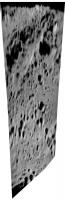
This is Clementine long wavelength infrared - the best resolution except for the HIRES camera, which only worked well near the poles - at the SMART-1 impact site. The target is slightly east of this strip. I'm looking at the next strip over now.
Phil
-------------------- ... because the Solar System ain't gonna map itself.
Also to be found posting similar content on https://mastodon.social/@PhilStooke Maps for download (free PD: https://upload.wikimedia.org/wikipedia/comm...Cartography.pdf NOTE: everything created by me which I post on UMSF is considered to be in the public domain (NOT CC, public domain) |
|
|
|
|
|
|
Sep 3 2006, 12:58 AM
Post
#60
|
|
|
Member Group: Members Posts: 548 Joined: 19-March 05 From: Princeton, NJ, USA Member No.: 212 |
A new update from Spaceflightnow.com
http://www.spaceflightnow.com/news/n0609/02smart1/ first few paragraphs below, has a few more tidbits compared to the ESA new release Europe's lunar orbiter to impact the moon Sunday BY STEPHEN CLARK SPACEFLIGHT NOW Posted: September 2, 2006 A European space probe is just hours away from a violent crash into the lunar surface that ground-based scientists hope will help answer debated questions about the Moon's sub-surface. The exact timing of the impact remains unknown, but European Space Agency officials say their most recent estimates place the event at 0542 GMT (1:42 a.m. EDT) Sunday morning. |
|
|
|
|
Sep 3 2006, 04:14 AM
Post
#61
|
||
|
Solar System Cartographer Group: Members Posts: 10196 Joined: 5-April 05 From: Canada Member No.: 227 |
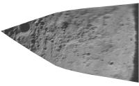
Well, unfortunately the Clementine LWIR image strips don't cover the nominal impact point. Here is a mosaic of four orbits, containing all the images in the area. The nominal impact point is right in the middle, between the two strips. Each strip is a composite of two orbits. This can be compared with the new AMIE mosaic to see where the strips lie.
LWIR images are difficult to process but give very nice views of the surface, as long as the point you want is covered! Phil (PS does anyone else on planet Earth actually use these images?)
-------------------- ... because the Solar System ain't gonna map itself.
Also to be found posting similar content on https://mastodon.social/@PhilStooke Maps for download (free PD: https://upload.wikimedia.org/wikipedia/comm...Cartography.pdf NOTE: everything created by me which I post on UMSF is considered to be in the public domain (NOT CC, public domain) |
|
|
|
|
|
|
Sep 3 2006, 05:29 AM
Post
#62
|
|
|
Member Group: Members Posts: 295 Joined: 2-March 04 From: Central California Member No.: 45 |
Does anyone know if there's anywhere on the web broadcasting live via telescope? I'm telescope challenged and was hoping to see the impact..
-------------------- Eric P / MizarKey
|
|
|
|
|
Sep 3 2006, 05:51 AM
Post
#63
|
|
 Member Group: Members Posts: 124 Joined: 23-March 06 Member No.: 723 |
QUOTE (MizarKey @ Sep 3 2006, 02:29 AM) Does anyone know if there's anywhere on the web broadcasting live via telescope? I'm telescope challenged and was hoping to see the impact.. Spaceflightnow ( www.spaceflightnow.com/news ) says the best phots might come from Amateur astronomers, the guys over at nasaspaceflight were running a live thread with impact images from a webcam inside the ESA controll room. Still no press release....but they have a lot of info on Europe's pre-impact activities as Smart-1 comes to an end The ESA website says 'ESA-webportal will publish results as soon as they are available late on 2 September and early on 3 September.' |
|
|
|
|
Sep 3 2006, 06:10 AM
Post
#64
|
|
|
Junior Member Group: Members Posts: 43 Joined: 10-December 05 Member No.: 605 |
According to the ESA, the impact took place according to schedule.
http://www.esa.int/SPECIALS/SMART-1/SEMBY5BVLRE_0.html |
|
|
|
|
Sep 3 2006, 07:05 AM
Post
#65
|
|
 Senior Member Group: Members Posts: 2228 Joined: 1-December 04 From: Marble Falls, Texas, USA Member No.: 116 |
I've been chasing the news, but it has been scarce so far. Apparently an observatory in Hawaii detected a "bright flash," according to this article.
-------------------- ...Tom
I'm not a Space Fan, I'm a Space Exploration Enthusiast. |
|
|
|
|
Sep 3 2006, 08:29 AM
Post
#66
|
|
|
Member Group: Members Posts: 249 Joined: 11-June 05 From: Finland (62°14′N 25°44′E) Member No.: 408 |
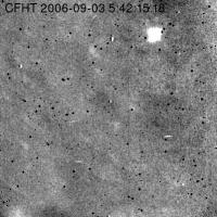
The CFHT image of the flash is available here.
-------------------- The universe is not only stranger than we imagine, it is stranger than we can imagine.
|
|
|
|
|
Sep 3 2006, 09:50 AM
Post
#67
|
|
|
Senior Member Group: Members Posts: 2492 Joined: 15-January 05 From: center Italy Member No.: 150 |
Thanks, Jyril... I suspect these are the very first published images of the impact.
About the flash, apparently the explosion is big: it's apparent size is 24 pixel (or 7 arcsec) in the outermost part and 9pixel/2.7arcsec in the inner/most luminous (saturated?) region... these numbers correspond to a "hot gas bubble" of 5-12Km diameter. I do not know if these value are "real" because, even if well above instrument resolution (a fraction of arcsec, see here), we do not know the atmospheric conditions and they do not published the FWHM figure... in fact, I suspect that the true moon surface detail are the very blurred (do not considetr the very dark spots or other bright, well defined features probably arising from the sensor) and, based on this, seeing is very bad and SN ratio is high. Probably, only some convoluted image can tell us real size of the bubble. Obviously, SMART crater isn't visible (should be less than 1/60 pixel size)
-------------------- I always think before posting! - Marco -
|
|
|
|
|
Sep 3 2006, 10:30 AM
Post
#68
|
|
|
Senior Member Group: Members Posts: 3648 Joined: 1-October 05 From: Croatia Member No.: 523 |
I suspect the brightness of the flash will be much more useful than measuring its dimensions (which is very dependant on seeing conditions, instrument characteristics and the sort). I wonder if any good spectra were acquired?
-------------------- |
|
|
|
| Guest_Sunspot_* |
Sep 3 2006, 10:44 AM
Post
#69
|
|
Guests |
The impact site would be a good target for the future Lunar Reconaissance orbiter..
|
|
|
|
|
Sep 3 2006, 11:44 AM
Post
#70
|
|
|
Senior Member Group: Members Posts: 1870 Joined: 20-February 05 Member No.: 174 |
Given the low impact speed, this is *not* a hypervelocity impact. Metal and rock debris leaving the impact crater at high velocity will be hot, but probably barely hot enough to glow thermally at visual wavelengths. <I'd like to see a calculation on the maximum kinetic heating possible> There should be some visible flash from remaining hydrazine and maybe shorting batteries and the like.. hard to guess how much.
I'd think a flash would be much more visible at thermal infrared wavelengths.. 5 micrometer or longer. Having an acutal flash dection will pinpoint the impact point better than raw spacecraft L.O.S. timing, I'd presume, and provide a good coordinate for future high and eventually ultra-high imaging. |
|
|
|
|
Sep 3 2006, 11:55 AM
Post
#71
|
|
 Member Group: Members Posts: 124 Joined: 23-April 05 Member No.: 358 |
|
|
|
|
|
Sep 3 2006, 12:28 PM
Post
#72
|
|
|
Member Group: Members Posts: 548 Joined: 19-March 05 From: Princeton, NJ, USA Member No.: 212 |
There are some brief reports at the Planetary society website;
http://www.planetary.org/blog/article/00000688/ http://www.planetary.org/blog/article/00000686/ (includes a beautiful mosaic of the impact region from ESA, also at ESA site) mosaic link: http://esamultimedia.esa.int/images/smart_...onAMIEMap_H.jpg there are about 4. check the weblog for more: Just As Planned Sep. 2, 2006 | 23:00 PDT | Sep. 3 06:00 UTC Weblog Archiveby Jennifer Vaughn SMART-1 scientist Detlef Koschy confirmed that mission control lost the SMART-1 signal at 10:42:19. He reported that folks at ESOC applauded when the "mission ended just as planned." Team members at ESOC are now downloading final pictures. SMART-1 took images up to about 5 minutes before impact. We also heard from a group of amateur astronomers who have set up at Los Angeles' Griffith Observatory. They did not observe anything unusual, nor did we see anything here at The Planetary Society. We're still waiting to hear from the worldwide network of observatories to see if an impact blast or ejecta plume was seen. |
|
|
|
| Guest_Myran_* |
Sep 3 2006, 12:42 PM
Post
#73
|
|
Guests |
I can only confirm whats been said, but yes the Swedish Space Corporation have that image up now also with a link to the Canada France Hawaii Telescope.
Someone might wonder what the Swedish Space Corporation got to do with SMART? Well SMART was proposed and designed by SSC, and built by Saab/Ericsson space (Formerly Saab-aerospace) in Linköping Sweden. After completion SMART was handed over to ESA for launch and the daily operations of the mission. |
|
|
|
|
Sep 3 2006, 03:47 PM
Post
#74
|
|
|
Solar System Cartographer Group: Members Posts: 10196 Joined: 5-April 05 From: Canada Member No.: 227 |
I was just thinking about how many things have hit or landed on the moon... some we might be uncertain about - are the Soviet orbiters still in orbit, for instance? - Luna 10 was high enough that it may still be in orbit - but making a few assumptions, I think SMART-1 may be the 60th spacecraft to reach the surface. I count 20 Lunas (including upper stages of two of them), five Rangers, seven Surveyors, five Lunar Orbiters, 20 bits of Apollo hardware, Hiten, Prospector and SMART-1. I'm not counting things like the Luna 9 landing stage or the Surveyor main engines, ejected before landing, and I'm not counting Luna 17 and Lunokhod 1 (etc) as two items. So a bit of a fudged list.
Some we can't locate on a map - e.g. the Apollo 16 LM ascent stage or the Apollo 15 subsatellite. I think that 50 could be plotted on a map. -------------------- ... because the Solar System ain't gonna map itself.
Also to be found posting similar content on https://mastodon.social/@PhilStooke Maps for download (free PD: https://upload.wikimedia.org/wikipedia/comm...Cartography.pdf NOTE: everything created by me which I post on UMSF is considered to be in the public domain (NOT CC, public domain) |
|
|
|
|
Sep 3 2006, 05:49 PM
Post
#75
|
|
|
Junior Member Group: Members Posts: 81 Joined: 19-April 05 Member No.: 256 |
Not sure if the telescope/camera has the resolution to pick out a crater from the impact, but it sure
looks like there is something visible from the before and after pictures. 
|
|
|
|
|
Sep 3 2006, 05:55 PM
Post
#76
|
|
|
Founder Group: Chairman Posts: 14433 Joined: 8-February 04 Member No.: 1 |
The crater is expected to be 3 x 10m..... you're not going to see if from the ground. You're not going to see if with Hubble. You're not going to see it until LRO starts mapping at 50cm/pixel in a few years time.
Doug |
|
|
|
|
Sep 3 2006, 06:07 PM
Post
#77
|
|
|
Junior Member Group: Members Posts: 81 Joined: 19-April 05 Member No.: 256 |
True, the actual crater may not be visible, but the ejecta may change the albedo for a much broader area on the order of hundreds of square meters. But even this may not show up with a wide angle view. I look
forward to some high res pictures of the area. |
|
|
|
|
Sep 3 2006, 06:41 PM
Post
#78
|
||
|
Solar System Cartographer Group: Members Posts: 10196 Joined: 5-April 05 From: Canada Member No.: 227 |
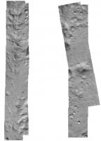
The Apollo 14 LM ascent stage impacted in a mare area west of the landing site. Its impact crater was not seen, but its ejecta was identified by Ewen Whitaker (Apollo 16 Preliminary Science Report). (just to show that the crater itself need not be visible).
Phil A is Apollo 12 image AS12-56-8439, showing the location of B. B is part of Apollo 16 metric camera frame 2508 rectified from its original oblique geometry.
-------------------- ... because the Solar System ain't gonna map itself.
Also to be found posting similar content on https://mastodon.social/@PhilStooke Maps for download (free PD: https://upload.wikimedia.org/wikipedia/comm...Cartography.pdf NOTE: everything created by me which I post on UMSF is considered to be in the public domain (NOT CC, public domain) |
|
|
|
|
|
|
Sep 3 2006, 06:53 PM
Post
#79
|
||
|
Senior Member Group: Members Posts: 1636 Joined: 9-May 05 From: Lima, Peru Member No.: 385 |
Approximate impact zone:
The impact region lies about two-thirds down, directly above the small gap in the mosaic, just south-east of the small crater Palmieri A in the direction of crater Doppelmayer W ESA estimates that impact occurred at 46.2º West, 34.4º South. I have enclosed a pinpoint impact zone:
Rodolfo |
|
|
|
|
|
|
Sep 3 2006, 07:05 PM
Post
#80
|
|
|
Junior Member Group: Members Posts: 81 Joined: 19-April 05 Member No.: 256 |
From Space.com article.
"Dust and other material ejected off the Moon were expected to possibly be visible to observers with big telescopes back here on Earth." |
|
|
|
|
Sep 3 2006, 07:28 PM
Post
#81
|
|
|
Member Group: Members Posts: 688 Joined: 20-April 05 From: Sweden Member No.: 273 |
QUOTE (garybeau @ Sep 3 2006, 09:05 PM) From Space.com article. "Dust and other material ejected off the Moon were expected to possibly be visible to observers with big telescopes back here on Earth." You'd have to be very fast. Dust is ballistic on the Moon. tty |
|
|
|
|
Sep 4 2006, 02:21 AM
Post
#82
|
||
|
Solar System Cartographer Group: Members Posts: 10196 Joined: 5-April 05 From: Canada Member No.: 227 |
It's not easy to compare the CFHT image of the flash with the AMIE map, but using the Consolidated Lunar Atlas as an intermediate step, I think this is the location of the flash:
Almost exactly where it was expected, but maybe slightly east of the expected groundtrack. Of course, the observers will do better, but it's interesting to try. Phil -------------------- ... because the Solar System ain't gonna map itself.
Also to be found posting similar content on https://mastodon.social/@PhilStooke Maps for download (free PD: https://upload.wikimedia.org/wikipedia/comm...Cartography.pdf NOTE: everything created by me which I post on UMSF is considered to be in the public domain (NOT CC, public domain) |
|
|
|
|
|
|
Sep 4 2006, 03:23 PM
Post
#83
|
|
|
Rover Driver Group: Members Posts: 1015 Joined: 4-March 04 Member No.: 47 |
|
|
|
|
|
Sep 4 2006, 07:42 PM
Post
#84
|
||
|
Solar System Cartographer Group: Members Posts: 10196 Joined: 5-April 05 From: Canada Member No.: 227 |
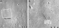
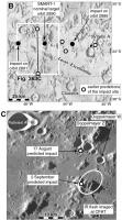
This is my current SMART-1 map, as I understand it now, or think I do. The last item to be plugged into my book except for the foreword, which is now being written.
There's a bit of confusion sometimes between periapsis and impact points, but I think I have it sorted out in the top map - B -. White dots are pre-August impact predictions, black dots are August 17 predictions. In the lower image - C -, plotted on an AMIE mosaic (original provided by Bernard Foing with his permission to use it), I show the August 17 and September 2 predictions and what i think is the location of the IR flash seen at CFHT. Phil
Attached thumbnail(s)
-------------------- ... because the Solar System ain't gonna map itself.
Also to be found posting similar content on https://mastodon.social/@PhilStooke Maps for download (free PD: https://upload.wikimedia.org/wikipedia/comm...Cartography.pdf NOTE: everything created by me which I post on UMSF is considered to be in the public domain (NOT CC, public domain) |
|
|
|
|
|
|
Sep 4 2006, 08:00 PM
Post
#85
|
|
|
Rover Driver Group: Members Posts: 1015 Joined: 4-March 04 Member No.: 47 |
Fig 363? I am looking forward to your book! It must be well illustrated
|
|
|
|
|
Sep 5 2006, 02:11 PM
Post
#86
|
||
|
Solar System Cartographer Group: Members Posts: 10196 Joined: 5-April 05 From: Canada Member No.: 227 |
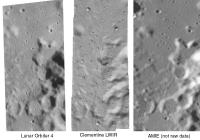
Here is a side by side comparison of an area immediately to the west of the SMART-1 impact point (west of it because the Clementine image doesn't cross the impact site itself).
I'm comparing Lunar Orbiter 4 - the new USGS digital version - with Clementine long-wavelength infrared (LWIR) and AMIE. Warning - this is not a fair comparison for AMIE because it's not raw data. This is just cropped out of the big mosaic of the landing area recently posted. This shows LO4 and Clem at full resolution. The AMIE image is enlarged to match the scale, hence its fuzziness. It is possible that raw AMIE images would equal the resolution of the other two, or get fairly close, near the periapsis latitude. A few other points can be made - the lighting is reversed from Lunar Orbiter, so areas lost in shadow in Orbiter will be seen in AMIE and vice versa - especially important near the poles. And Orbiter coverage of the farside is inferior to this nearside area, so AMIE will at least equal it in many areas. And the Clem LWIR is only available in narrow strips. So we benefit most by having access to all three types of image. AMIE apparently took 20,000 images. When they are released - and especially if good global mosaics are constructed - they will be a very useful addition to lunar databases. And let's not forget that, although several other orbiters are planned, we don't know how many will actually fly successfully. Phil
-------------------- ... because the Solar System ain't gonna map itself.
Also to be found posting similar content on https://mastodon.social/@PhilStooke Maps for download (free PD: https://upload.wikimedia.org/wikipedia/comm...Cartography.pdf NOTE: everything created by me which I post on UMSF is considered to be in the public domain (NOT CC, public domain) |
|
|
|
|
|
|
Sep 5 2006, 03:44 PM
Post
#87
|
|
|
Senior Member Group: Members Posts: 1636 Joined: 9-May 05 From: Lima, Peru Member No.: 385 |
It is evident that Clementine LWIR has better pictures than Lunar Orbiter 4 and the ones of AMIES looks fuzzier due to the stretch
The morphology of Lunar surface has made me to be inquietant. Its tendency of forming the surface does not agree to others places such as Earth and Mars in which they surface are constantly eroded by others process. Rodolfo P.D. |
|
|
|
|
Sep 5 2006, 03:48 PM
Post
#88
|
|
|
Founder Group: Chairman Posts: 14433 Joined: 8-February 04 Member No.: 1 |
QUOTE (RNeuhaus @ Sep 5 2006, 04:44 PM) due to the scratch process Scratch process? Doug |
|
|
|
|
Sep 5 2006, 03:58 PM
Post
#89
|
|
|
Senior Member Group: Members Posts: 1636 Joined: 9-May 05 From: Lima, Peru Member No.: 385 |
QUOTE (djellison @ Sep 5 2006, 10:48 AM) Scratch process? Doug Already corrected --> Stretch Thanks, Rodolfo |
|
|
|
|
Sep 5 2006, 03:59 PM
Post
#90
|
|
|
Founder Group: Chairman Posts: 14433 Joined: 8-February 04 Member No.: 1 |
Well - I'll still ask the same question - why do the images look fuzzy because of a 'stretch' process?
Doug |
|
|
|
|
Sep 5 2006, 04:16 PM
Post
#91
|
|
|
Senior Member Group: Members Posts: 1636 Joined: 9-May 05 From: Lima, Peru Member No.: 385 |
QUOTE (djellison @ Sep 5 2006, 10:59 AM) Well - I'll still ask the same question - why do the images look fuzzy because of a 'stretch' process? Doug It is according to Phil's post http://www.unmannedspaceflight.com/index.p...ost&p=66774 The AMIE image is enlarged to match the scale, hence its fuzziness. Rodolfo |
|
|
|
|
Sep 5 2006, 04:23 PM
Post
#92
|
|
 The Poet Dude Group: Moderator Posts: 5551 Joined: 15-March 04 From: Kendal, Cumbria, UK Member No.: 60 |
-------------------- |
|
|
|
|
Sep 5 2006, 04:27 PM
Post
#93
|
|
 Member Group: Members Posts: 562 Joined: 29-March 05 Member No.: 221 |
|
|
|
|
|
Sep 5 2006, 04:35 PM
Post
#94
|
|
|
The Poet Dude Group: Moderator Posts: 5551 Joined: 15-March 04 From: Kendal, Cumbria, UK Member No.: 60 |
Don't be silly. Button Moon was just puppets. Everyone knows the Clangers are real...
-------------------- |
|
|
|
|
Sep 5 2006, 04:54 PM
Post
#95
|
|
|
Member Group: Members Posts: 562 Joined: 29-March 05 Member No.: 221 |
QUOTE (Stu @ Sep 5 2006, 05:35 PM) Don't be silly. Button Moon was just puppets. noooooo say it ain't so.... It's real dammit! It has to be.... |
|
|
|
|
Sep 5 2006, 05:01 PM
Post
#96
|
|
|
The Poet Dude Group: Moderator Posts: 5551 Joined: 15-March 04 From: Kendal, Cumbria, UK Member No.: 60 |
QUOTE (paxdan @ Sep 5 2006, 04:54 PM) noooooo say it ain't so.... It's real dammit! It has to be.... C'mon man, you can see the strings... ain't no strings on Clangers... ("What's that Soup Dragon? Some inconsiderate European guy dropped a ruddy great washing machine sized spaceprobe on your cave and now there's no blue string soup? How terrible!") 
-------------------- |
|
|
|
|
Sep 5 2006, 06:43 PM
Post
#97
|
|
|
Dublin Correspondent Group: Admin Posts: 1799 Joined: 28-March 05 From: Celbridge, Ireland Member No.: 220 |
QUOTE (Stu @ Sep 5 2006, 06:01 PM) ("What's that Soup Dragon? Some inconsiderate European guy dropped a ruddy great washing machine sized spaceprobe on your cave and now there's no blue string soup? How terrible!") Priceless Stu...
|
|
|
|
|
Sep 6 2006, 01:13 PM
Post
#98
|
|
|
Special Cookie Group: Members Posts: 2168 Joined: 6-April 05 From: Sintra | Portugal Member No.: 228 |
QUOTE (garybeau @ Sep 3 2006, 07:07 PM) True, the actual crater may not be visible, but the ejecta may change the albedo for a much broader area on the order of hundreds of square meters. But even this may not show up with a wide angle view. I look forward to some high res pictures of the area. But there are some slightly visible changes on the ground from the 15secs before and 15secs after the impact images: http://i16.photobucket.com/albums/b14/ustrax3/smart1.jpg -------------------- "Ride, boldly ride," The shade replied, "If you seek for Eldorado!"
Edgar Alan Poe |
|
|
|
|
Sep 6 2006, 01:26 PM
Post
#99
|
|
|
Founder Group: Chairman Posts: 14433 Joined: 8-February 04 Member No.: 1 |
I was about to say... How do you know it's changes to the ground and not an ejecta cloud..
Then I thought -hmm - I'll do some image work myself - where's the movie... Then went to find it and found this http://sci.esa.int/science-e/www/object/in...fobjectid=39968 Doug |
|
|
|
|
Sep 6 2006, 01:34 PM
Post
#100
|
|
|
Rover Driver Group: Members Posts: 1015 Joined: 4-March 04 Member No.: 47 |
is that a simple differencing of the images wrt the pre-impact image? Looks cool though!
edit - here's the animation of it...you can clearly see somthing hitting from above and then making a crash landing like longjumpers do http://www.cfht.hawaii.edu/News/Smart1/#Dust |
|
|
|
 |

|
Lo-Fi Version | Time is now: 21st June 2024 - 12:39 PM |
|
RULES AND GUIDELINES Please read the Forum Rules and Guidelines before posting. IMAGE COPYRIGHT |
OPINIONS AND MODERATION Opinions expressed on UnmannedSpaceflight.com are those of the individual posters and do not necessarily reflect the opinions of UnmannedSpaceflight.com or The Planetary Society. The all-volunteer UnmannedSpaceflight.com moderation team is wholly independent of The Planetary Society. The Planetary Society has no influence over decisions made by the UnmannedSpaceflight.com moderators. |
SUPPORT THE FORUM Unmannedspaceflight.com is funded by the Planetary Society. Please consider supporting our work and many other projects by donating to the Society or becoming a member. |
|