South to Vera Rubin Ridge, (Sites 62-63, Sols 1659-1726, Apr 6 2017-Jun 14 2017) |

South to Vera Rubin Ridge, (Sites 62-63, Sols 1659-1726, Apr 6 2017-Jun 14 2017) |
 Apr 7 2017, 07:24 PM Apr 7 2017, 07:24 PM
Post
#1
|
|
|
Solar System Cartographer  Group: Members Posts: 10197 Joined: 5-April 05 From: Canada Member No.: 227 |
OK, we have left the dunes, and it's time for a new chapter in our story as we head south to Vera Rubin (formerly known as Hematite) Ridge.
Phil -------------------- ... because the Solar System ain't gonna map itself.
Also to be found posting similar content on https://mastodon.social/@PhilStooke Maps for download (free PD: https://upload.wikimedia.org/wikipedia/comm...Cartography.pdf NOTE: everything created by me which I post on UMSF is considered to be in the public domain (NOT CC, public domain) |
 |
 
|
 |
|
Apr 7 2017, 08:19 PM
Post
#2
|
||
|
Solar System Cartographer Group: Members Posts: 10197 Joined: 5-April 05 From: Canada Member No.: 227 |
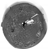
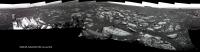
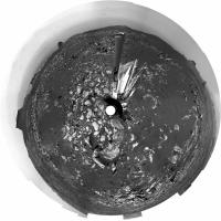
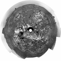
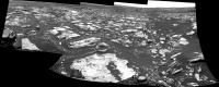
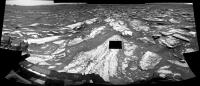
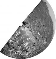
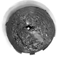
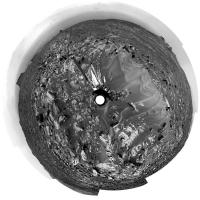
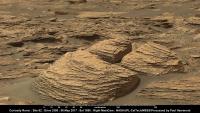
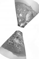
OK, we are on the road, and here is a circular version of Jan's sol 1659 panorama to get us started.
Phil
-------------------- ... because the Solar System ain't gonna map itself.
Also to be found posting similar content on https://mastodon.social/@PhilStooke Maps for download (free PD: https://upload.wikimedia.org/wikipedia/comm...Cartography.pdf NOTE: everything created by me which I post on UMSF is considered to be in the public domain (NOT CC, public domain) |
|
|
|
|
|
|
Apr 8 2017, 09:39 PM
Post
#3
|
||
 Senior Member Group: Members Posts: 2430 Joined: 30-January 13 From: Penang, Malaysia. Member No.: 6853 |
Mission Update from Ryan Anderson: Sols 1661-1663: DAN has been busy
QUOTE Our drive away from the Ogunquit Beach sand dune location went well, taking us about 35 meters to the southwest and putting us in a good location to continue measuring the composition of the bedrock as we drive up Mt. Sharp. The Sol 1661 plan starts out with a Mastcam mosaic of Old Speck Mountain and some Navcam cloud detection observations. ChemCam will then analyze the targets Blueberry Mountain, Brewer Mountain, and Mud Hole with Mastcam documentation images for each target. I also requested some long distance ChemCam images of a cliff face on Mt. Sharp. I wasnt able to participate in planning today, so we will see if the instructions I left the uplink team were correct! Once the remote sensing is done, MAHLI will take some pictures of the targets Paradise Hill and Treasure Island. APXS will then analyze both targets, with an overnight analysis of Treasure Island. On Sol 1662 we will drive again, followed by an autonomously targeted ChemCam observation, and on sol 1663 Curiosity will have a pretty easy day, with some Mastcam atmospheric dust measurements and a MARDI image of the ground beneath the rover. Throughout this week, the environmental science group has been working to recover the activities that were lost last weekend because of the Deep Space Network outage, such as the morning imaging suite and 15-frame Navcam dust devil movie, while also continuing the normal cadence of monitoring activities. Earlier in the week, a special DAN active measurement was acquired over the sand of Ogunquit Beach. By turning the rover in place and backing up onto the dune, we placed the field of view of DAN's active neutron experiment, which is centered between the rear two wheels, right on the dune sand. DAN active experiments are performed after each rover position change (usually immediately after a drive), but in this case, the measurement was taken just before the rover departed Ogunquit Beach. In a DAN active measurement, neutrons are fired in all directions by the Pulse Neutron Generator, and some neutrons scattered by the soil under the rover return to the DAN detectors. This measurement will allow DAN to compare the amount of hydrogen measured at Namib Dune around sol 1243 to the conditions at Ogunquit Beach.
|
|
|
|
|
|
|
Apr 10 2017, 10:39 AM
Post
#4
|
||
|
Senior Member Group: Members Posts: 2430 Joined: 30-January 13 From: Penang, Malaysia. Member No.: 6853 |
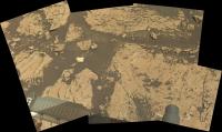
Not much here really (1662 L-NavCam partial) but it's all there is until more frames come down... Midnight Planets reports it as: Curiosity moved approximately 24.1m SSW (-158º) on Sol 1662
|
|
|
|
|
|
|
Apr 10 2017, 07:23 PM
Post
#5
|
||
 Senior Member Group: Members Posts: 4252 Joined: 17-January 05 Member No.: 152 |
DD activity has been quiet recently, but here's a large (or close) DD on 1660:
It moved right to left (note the negative image). I think it's behind the distant knob, which would make it very big. |
|
|
|
|
|
|
Apr 10 2017, 08:40 PM
Post
#6
|
||
|
Senior Member Group: Members Posts: 2842 Joined: 22-April 05 From: Ridderkerk, Netherlands Member No.: 353 |
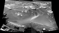
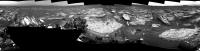
The Navcam L view on Sol 1662.
Jan van Driel
|
|
|
|
|
|
|
Apr 10 2017, 09:15 PM
Post
#7
|
||
|
Solar System Cartographer Group: Members Posts: 10197 Joined: 5-April 05 From: Canada Member No.: 227 |
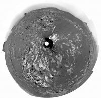
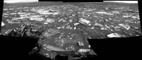
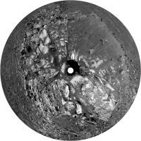
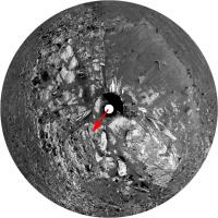
Thanks, Jan. Here is a circular version. We are creeping through the gap between the dunes.
Phil
-------------------- ... because the Solar System ain't gonna map itself.
Also to be found posting similar content on https://mastodon.social/@PhilStooke Maps for download (free PD: https://upload.wikimedia.org/wikipedia/comm...Cartography.pdf NOTE: everything created by me which I post on UMSF is considered to be in the public domain (NOT CC, public domain) |
|
|
|
|
|
|
Apr 11 2017, 05:12 AM
Post
#8
|
|
|
Senior Member Group: Members Posts: 2430 Joined: 30-January 13 From: Penang, Malaysia. Member No.: 6853 |
Curiosity Rover Mission Update: Sols 1664-1665: Keep on driving
QUOTE MSL drove about 24 meters on Sol 1662, and another drive is planned for Sol 1664. Before the drive, lots of targeted remote sensing is planned: ChemCam and Right Mastcam will observe a bright rock named "Peaks Island," an exposure of bedding dubbed "Great Wass Island," a sand ripple called "Baldpate Mountain," and an interesting rock that was selected by AEGIS after the Sol 1662 drive, now named "Chebeague Island." Mastcam will also acquire a stereo mosaic of outcrops toward the south, in the direction of the planned drive.
Planning is restricted this week, so two sols were planned today. Untargeted remote sensing planned for Sol 1665 includes passive (no laser) ChemCam sky observations and two ground LIBS targets selected using the AEGIS software. Navcam will then search for dust devils and clouds before the rover rests in preparation for Wednesday's plan. |
|
|
|
|
Apr 12 2017, 03:02 AM
Post
#9
|
||
|
Member Group: Members Posts: 866 Joined: 15-March 05 From: Santa Cruz, CA Member No.: 196 |
ICe stitch of the sol1661 chemcam. i think that section with the gouge has been chemcammed a month or three ago..?
|
|
|
|
|
|
|
Apr 12 2017, 03:51 AM
Post
#10
|
||
|
Senior Member Group: Members Posts: 2430 Joined: 30-January 13 From: Penang, Malaysia. Member No.: 6853 |
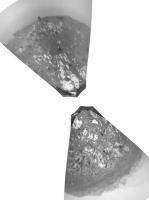
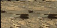
QUOTE (atomoid @ Apr 12 2017, 11:02 AM)  ICe stitch of the sol1661 chemcam. I found the pointing for the RMI's (169.48° to 171.78°), but would like to calculate the approximate height of the cliff face and or the width of the terrain covered by the mosaic. Google Earth (Pro) does not have high res map coverage in that section of the mountain, or I could have used their measuring tool for a rough guide based on the bearing. At that long range AlgorimancerPG would likely be of little use, even if I had the stereo pair to go with the frame below? Does anyone have an idea of the distance to the target? Or has someone already worked out the scale for this mosaic? TIA 
|
|
|
|
|
|
|
Apr 12 2017, 04:34 AM
Post
#11
|
|
 Administrator Group: Admin Posts: 5172 Joined: 4-August 05 From: Pasadena, CA, USA, Earth Member No.: 454 |
I don't have time to do this myself, but: take the CTX mosaic of the Curiosity landing site, crop it so that Curiosity's current position is at the center, use Photoshop polar > rectangular filter to "unwrap" the horizon, stretch or shrink it vertically as needed to make the horizon legible, and compare it to a Navcam panorama to locate the peaks. (If you don't use PShop I'd be shocked if GIMP didn't have a similar filter.)
-------------------- My website - My Patreon - @elakdawalla on Twitter - Please support unmannedspaceflight.com by donating here.
|
|
|
|
|
Apr 12 2017, 05:39 AM
Post
#12
|
||
|
Senior Member Group: Members Posts: 2430 Joined: 30-January 13 From: Penang, Malaysia. Member No.: 6853 |
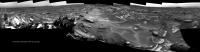
QUOTE (elakdawalla @ Apr 12 2017, 12:34 PM) ....CTX mosaic of the Curiosity landing site... Thanks Emily, I look at that process.... Meanwhile Curi has driven as planned, no distance data yet but we have a few end of drive NavCam frames, I will stitch what I can soon. Here is a RMI mosaic acquired before the drive to Site 62/0690 of what I believe to be The 'Exposure of Bedding dubbed 'Great Wass Island' mentioned in the recent USGS update. The pointing is currently shown as above the horizon so I cant accurately locate on the NavCams, nor scale it at the moment, but likely close to the rover.
|
|
|
|
|
|
|
Apr 12 2017, 01:08 PM
Post
#13
|
|
|
Solar System Cartographer Group: Members Posts: 10197 Joined: 5-April 05 From: Canada Member No.: 227 |
If there was any move at all it can only have been a few metres. Maybe stopped prematurely.
Phil -------------------- ... because the Solar System ain't gonna map itself.
Also to be found posting similar content on https://mastodon.social/@PhilStooke Maps for download (free PD: https://upload.wikimedia.org/wikipedia/comm...Cartography.pdf NOTE: everything created by me which I post on UMSF is considered to be in the public domain (NOT CC, public domain) |
|
|
|
|
Apr 12 2017, 01:39 PM
Post
#14
|
||
|
Senior Member Group: Members Posts: 2430 Joined: 30-January 13 From: Penang, Malaysia. Member No.: 6853 |
QUOTE (Phil Stooke @ Apr 12 2017, 09:08 PM) Maybe stopped prematurely. Agreed, very short indeed, more of a bump... Here is the R-NavCam mosaic in MS ICE using 17 frames, quick and dirty as usual for ICE... Link for full resolution version hosted on IMGUR that may suffice until Jan can work his magic... Much reduced version below, use the link above for the full resolution version
|
|
|
|
|
|
|
Apr 12 2017, 08:14 PM
Post
#15
|
||
|
Senior Member Group: Members Posts: 2842 Joined: 22-April 05 From: Ridderkerk, Netherlands Member No.: 353 |
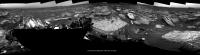
The Navcam L view on Sol 1664.
Jan van Driel
|
|
|
|
|
|
|
Apr 14 2017, 03:06 AM
Post
#16
|
||
|
Senior Member Group: Members Posts: 2430 Joined: 30-January 13 From: Penang, Malaysia. Member No.: 6853 |
Sol 1666: The short drive up to 'Moosehead Lake' looks to have completed successfully after the drive that halted early on 1664 see USGS Update
Edit: Midnight planets reports the drive as approximately 9.2m S (-177º) Link
|
|
|
|
|
|
|
Apr 14 2017, 09:36 PM
Post
#17
|
||
 Member Group: Members Posts: 684 Joined: 24-July 15 Member No.: 7619 |
QUOTE (PaulH51 @ Apr 14 2017, 03:06 AM) Sol 1666: The short drive up to 'Moosehead Lake' looks to have completed successfully after the drive that halted early on 1664 see USGS Update Edit: Midnight planets reports the drive as approximately 9.2m S (-177º) Link
Ok, now that's different... Don't recall seeing anything similar before. When do we expect to start getting to the caprock / hematite, or are were there? |
|
|
|
|
|
|
Apr 14 2017, 10:10 PM
Post
#18
|
|
|
Senior Member Group: Members Posts: 2430 Joined: 30-January 13 From: Penang, Malaysia. Member No.: 6853 |
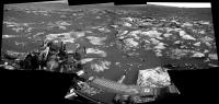
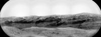
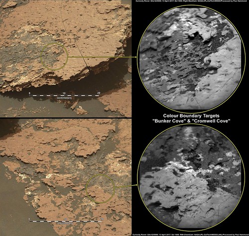
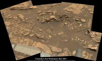
QUOTE (HSchirmer @ Apr 15 2017, 05:36 AM) Don't recall seeing anything similar before.... Here is 'Moosehead Lake' in a R-MastCam cropped mosaic from Sol 1664 (pre-drive) 1-meter scale bar added (AlgorimancerPG) Full resolution 2765x1555px Link 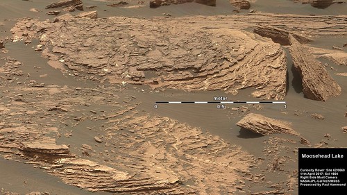 |
|
|
|
|
Apr 15 2017, 01:34 AM
Post
#19
|
||
|
Senior Member Group: Members Posts: 2430 Joined: 30-January 13 From: Penang, Malaysia. Member No.: 6853 |
USGS Mission Update by Ryan Anderson Sols 1668-1670: Diving into (analysis of) Moosehead Lake
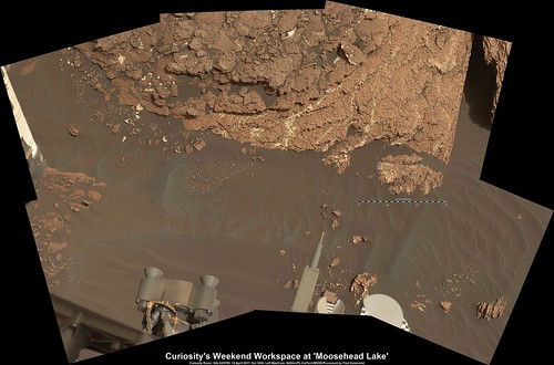
QUOTE Our latest drive put us in position in front of the interesting Moosehead Lake outcrop with lots of veins and grey patches: plenty to keep Curiosity busy over the weekend! The Sol 1668 plan starts off with a nice long science block. ChemCam has observations of targets Sheldrake Island, Crabtree Neck, Waukeah Neck, Morancy Stream and Ogden Point. This is followed by a dust devil survey and several Mastcam mosaics. These include one covering Moosehead Lake, a few frames to extend the coverage of the area near the rover, and a big 22 frame mosaic of the outcrop at our next stop. Mastcam will also take a picture of the ChemCam auto-targeted location from after the drive. After that MAHLI will take pictures of the targets Morancy Stream and Sheldrake Island and then APXS will analyze those two targets. On Sol 1669, well retract the arm and drive, followed by post-drive imaging and a MARDI observation in the evening. On Sol 1670, there is a short morning block of atmospheric observations and a longer afternoon block containing a Mastcam image of the rover deck, another dust devil observation, and an auto-targeted ChemCam observation. We will wrap up Sol 1670 with some observations of the dust in the atmosphere to compare with the morning. Speaking of atmospheric observations, lets do a recap of the environmental science weve done this week. Of course Curiosity acquired the usual REMS and DAN measurements as well as Navcam cloud observation movies throughout the week. The pointing direction of the cloud movies was shifted from north-facing to south-facing to avoid the sun. The movies will remain pointed towards the south until just after the southern hemisphere spring equinox in May 2018. As mentioned above, there was a Navcam dust devil survey on Sol 1670, as well as one earlier in the week on sol 1668. Also captured earlier this week in ENV planning was a ChemCam passive sky observation on sol 1665 that had been previously dropped twice from the plan due to the DSN outage two weeks ago and sun safety issues last week. Planning passive sky observations is difficult: they are among the most time consuming and time constrained atmospheric observations. This is because the observation requires ChemCam to take passive spectra of the sky at two different azimuths and ChemCam must avoid the suns path as it slews between those locations. This can be difficult near equinoxes when the sun passes directly overhead!
|
|
|
|
|
|
|
Apr 15 2017, 01:38 PM
Post
#20
|
||
|
Senior Member Group: Members Posts: 2842 Joined: 22-April 05 From: Ridderkerk, Netherlands Member No.: 353 |
The Navcam L view on Sol 1666.
Jan van Driel
|
|
|
|
|
|
|
Apr 15 2017, 03:17 PM
Post
#21
|
||
|
Solar System Cartographer Group: Members Posts: 10197 Joined: 5-April 05 From: Canada Member No.: 227 |
Thanks, Jan. Here is a circular view of it. The position next to the large patch of rock slabs is easily matched to the HiRISE view.
Phil
-------------------- ... because the Solar System ain't gonna map itself.
Also to be found posting similar content on https://mastodon.social/@PhilStooke Maps for download (free PD: https://upload.wikimedia.org/wikipedia/comm...Cartography.pdf NOTE: everything created by me which I post on UMSF is considered to be in the public domain (NOT CC, public domain) |
|
|
|
|
|
|
Apr 16 2017, 02:17 AM
Post
#22
|
|
|
Senior Member Group: Members Posts: 2430 Joined: 30-January 13 From: Penang, Malaysia. Member No.: 6853 |
1666 MS ICE L-MastCam 'arm workspace' with 30 cm scale-bar (AlgorimancerPG)
 Browse image [1024x675px] Full resolution image [3898x2569] |
|
|
|
|
Apr 16 2017, 11:33 PM
Post
#23
|
|
|
Senior Member Group: Members Posts: 2430 Joined: 30-January 13 From: Penang, Malaysia. Member No.: 6853 |
|
|
|
|
|
Apr 17 2017, 08:19 AM
Post
#24
|
||
|
Senior Member Group: Members Posts: 2430 Joined: 30-January 13 From: Penang, Malaysia. Member No.: 6853 |
And the 1669 drive images all came down in one shot
Quick and Dirty in MS ICE, but the rather nice outcrops in the pan may help establish the location until Jan can post his proper version...Reduced preview and link to full resolution below: EDIT Drive reported by MP as @Curiosity moved approximately 28.4m SSE (147º) on Sol 1669" Image Link Tweet Link
Link to Full Size on IMGUR |
|
|
|
|
|
|
Apr 17 2017, 08:51 AM
Post
#25
|
||
|
Senior Member Group: Members Posts: 2430 Joined: 30-January 13 From: Penang, Malaysia. Member No.: 6853 |
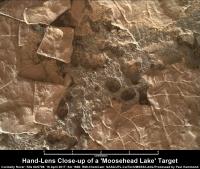
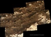
One of the 1668 'Moosehead Lake' focus merged MAHLIs ('Morancy Stream' or 'Sheldrake Island'). Scale bar thanks to Gerald and the focus motor count. Some really nice details in this set of images LINK
|
|
|
|
|
|
|
Apr 17 2017, 11:42 AM
Post
#26
|
|
|
Member Group: Members Posts: 915 Joined: 4-September 06 From: Boston Member No.: 1102 |
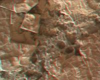
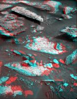
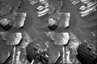
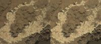
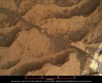
Sand crepes. It looks like the delicates crepe is placed on top of a layer of sand. In the image above, are the sandy areas -- low spots that accumulated sand, or are they -- high spots where the crepe has eroded and exposed sand?
-------------------- |
|
|
|
|
Apr 17 2017, 12:06 PM
Post
#27
|
||
|
Senior Member Group: Members Posts: 2430 Joined: 30-January 13 From: Penang, Malaysia. Member No.: 6853 |
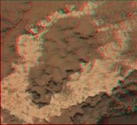
QUOTE (Floyd @ Apr 17 2017, 07:42 PM) Sand crepes... are the sandy areas -- low spots that accumulated sand, or are they -- high spots where the crepe has eroded and exposed sand? This red/cyan anaglyph may help you decide... Hope you have the appropriate glasses?
|
|
|
|
|
|
|
Apr 17 2017, 12:09 PM
Post
#28
|
||
|
Solar System Cartographer Group: Members Posts: 10197 Joined: 5-April 05 From: Canada Member No.: 227 |
Thanks for the panorama, Paul - here is a circular view to show our new location.
Phil
-------------------- ... because the Solar System ain't gonna map itself.
Also to be found posting similar content on https://mastodon.social/@PhilStooke Maps for download (free PD: https://upload.wikimedia.org/wikipedia/comm...Cartography.pdf NOTE: everything created by me which I post on UMSF is considered to be in the public domain (NOT CC, public domain) |
|
|
|
|
|
|
Apr 17 2017, 01:55 PM
Post
#29
|
||
|
Senior Member Group: Members Posts: 2842 Joined: 22-April 05 From: Ridderkerk, Netherlands Member No.: 353 |
Here is my view of the Sol 1669 Panorama.
Jan van Driel
|
|
|
|
|
|
|
Apr 18 2017, 10:38 PM
Post
#30
|
|||||
|
Member Group: Members Posts: 866 Joined: 15-March 05 From: Santa Cruz, CA Member No.: 196 |
crosseyed/parallel version of that deliciously underlighted crepe from sol1668.. plus anaglyph/parallel of an interesting formation from sol1669, perhaps a rectangularly-eroded fracture fill remnant hanging precipitously at the end of its substrate, looking more like some sort of martian magic trick prop, or that rock has a cellphone..
|
||||
|
|
|
||||
|
Apr 19 2017, 02:15 AM
Post
#31
|
|
|
Senior Member Group: Members Posts: 1045 Joined: 17-February 09 Member No.: 4605 |
The "crepes" are really quite lovely. In parts the white deposit seems to morph into pinkish / tan. I would punt for a thin lamination of calcium sulphate with impurities.
|
|
|
|
|
Apr 19 2017, 12:44 PM
Post
#32
|
||
|
Solar System Cartographer Group: Members Posts: 10197 Joined: 5-April 05 From: Canada Member No.: 227 |
Just a few metres drive on sol 1671.
Phil
Attached thumbnail(s)
-------------------- ... because the Solar System ain't gonna map itself.
Also to be found posting similar content on https://mastodon.social/@PhilStooke Maps for download (free PD: https://upload.wikimedia.org/wikipedia/comm...Cartography.pdf NOTE: everything created by me which I post on UMSF is considered to be in the public domain (NOT CC, public domain) |
|
|
|
|
|
|
Apr 20 2017, 08:18 PM
Post
#33
|
||
|
Senior Member Group: Members Posts: 2842 Joined: 22-April 05 From: Ridderkerk, Netherlands Member No.: 353 |
The Navcam L view on Sol 1671.
Jan van Driel
|
|
|
|
|
|
|
Apr 21 2017, 07:54 AM
Post
#34
|
|
|
Senior Member Group: Members Posts: 2430 Joined: 30-January 13 From: Penang, Malaysia. Member No.: 6853 |
|
|
|
|
|
Apr 22 2017, 12:44 AM
Post
#35
|
|
|
Solar System Cartographer Group: Members Posts: 10197 Joined: 5-April 05 From: Canada Member No.: 227 |
An invaluable source of day to day news about Curiosity activities has been the USGS blog at:
https://astrogeology.usgs.gov/ It is mirrored at JPL at this URL: https://mars.jpl.nasa.gov/msl/mission/mars-...ission-updates/ - and at the moment that is being updated while the USGS site is not. Just in case anyone is looking for new updates. I know I do every day. Phil -------------------- ... because the Solar System ain't gonna map itself.
Also to be found posting similar content on https://mastodon.social/@PhilStooke Maps for download (free PD: https://upload.wikimedia.org/wikipedia/comm...Cartography.pdf NOTE: everything created by me which I post on UMSF is considered to be in the public domain (NOT CC, public domain) |
|
|
|
|
Apr 22 2017, 12:50 AM
Post
#36
|
|
|
Senior Member Group: Members Posts: 2430 Joined: 30-January 13 From: Penang, Malaysia. Member No.: 6853 |
QUOTE (Phil Stooke @ Apr 22 2017, 08:44 AM) It is mirrored at JPL.... Many thanks Phil.... |
|
|
|
|
Apr 22 2017, 11:09 AM
Post
#37
|
|
|
Senior Member Group: Members Posts: 2430 Joined: 30-January 13 From: Penang, Malaysia. Member No.: 6853 |
|
|
|
|
|
Apr 22 2017, 02:27 PM
Post
#38
|
||
|
Senior Member Group: Members Posts: 2842 Joined: 22-April 05 From: Ridderkerk, Netherlands Member No.: 353 |
Thhe Navcam L view on Sol 1672.
Jan van Driel
|
|
|
|
|
|
|
Apr 22 2017, 07:19 PM
Post
#39
|
||
|
Senior Member Group: Members Posts: 2842 Joined: 22-April 05 From: Ridderkerk, Netherlands Member No.: 353 |
and the L Navcam view on Sol 1673.
Jan van Driel
|
|
|
|
|
|
|
Apr 24 2017, 03:34 AM
Post
#40
|
|
|
Senior Member Group: Members Posts: 2430 Joined: 30-January 13 From: Penang, Malaysia. Member No.: 6853 |
Another periodic check of the deck mounted Rover Environmental Monitoring Station (REMS) Ultra-Violet Sensor (UVS) housing suggests a small increase in fine dust levels on the lenses of the 6 UV sensors.
Montage of a selection of checks (preview) with links below: 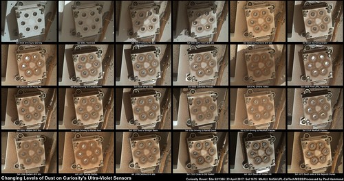 Flickr 1024x541px Link Flickr 9994x5276px Link |
|
|
|
|
Apr 24 2017, 07:37 AM
Post
#41
|
||
|
Senior Member Group: Members Posts: 2430 Joined: 30-January 13 From: Penang, Malaysia. Member No.: 6853 |
Sol 1676 drive of ~26 minutes, partial NavCam pan from the available left-side images, assembled in MS ICE, will add details as they are become available
EDIT, a few more images added...
|
|
|
|
|
|
|
Apr 24 2017, 12:04 PM
Post
#42
|
||
|
Solar System Cartographer Group: Members Posts: 10197 Joined: 5-April 05 From: Canada Member No.: 227 |
Reprojected hazcams for the sol 1676 drive. They should project to a wider angle than this suggests, but my ad hoc method produces a narrower image. Anyway, a very clear location comes from this.
Phil
-------------------- ... because the Solar System ain't gonna map itself.
Also to be found posting similar content on https://mastodon.social/@PhilStooke Maps for download (free PD: https://upload.wikimedia.org/wikipedia/comm...Cartography.pdf NOTE: everything created by me which I post on UMSF is considered to be in the public domain (NOT CC, public domain) |
|
|
|
|
|
|
Apr 24 2017, 01:17 PM
Post
#43
|
|
|
Senior Member Group: Members Posts: 2430 Joined: 30-January 13 From: Penang, Malaysia. Member No.: 6853 |
QUOTE (Phil Stooke @ Apr 24 2017, 08:04 PM) Reprojected hazcams for the sol 1676 drive. Midnight planets now reporting the drive as 'approximately 17.0m SSE (166º) on Sol 1676' Link |
|
|
|
|
Apr 24 2017, 04:18 PM
Post
#44
|
|
|
Administrator Group: Admin Posts: 5172 Joined: 4-August 05 From: Pasadena, CA, USA, Earth Member No.: 454 |
QUOTE (Phil Stooke @ Apr 21 2017, 04:44 PM) An invaluable source of day to day news about Curiosity activities has been the USGS blog at: https://astrogeology.usgs.gov/ It is mirrored at JPL at this URL: https://mars.jpl.nasa.gov/msl/mission/mars-...ission-updates/ - and at the moment that is being updated while the USGS site is not. Just in case anyone is looking for new updates. I know I do every day. Phil There's been a change in the ownership of the blog. Ashwin told me: "FYI we have changed our blogging from the USGS to JPL. The original 3 authors still participate, but weve recruited several more. The posts are now natively hosted at JPL (same web page) instead of mirroring USGS." -------------------- My website - My Patreon - @elakdawalla on Twitter - Please support unmannedspaceflight.com by donating here.
|
|
|
|
|
Apr 24 2017, 04:29 PM
Post
#45
|
|
|
Solar System Cartographer Group: Members Posts: 10197 Joined: 5-April 05 From: Canada Member No.: 227 |
Also, the JPL site contains archives all the way back to just before landing. At USGS the archiving arrangement was not easy to get into.
Phil -------------------- ... because the Solar System ain't gonna map itself.
Also to be found posting similar content on https://mastodon.social/@PhilStooke Maps for download (free PD: https://upload.wikimedia.org/wikipedia/comm...Cartography.pdf NOTE: everything created by me which I post on UMSF is considered to be in the public domain (NOT CC, public domain) |
|
|
|
|
Apr 24 2017, 06:16 PM
Post
#46
|
|
|
Member Group: Members Posts: 923 Joined: 10-November 15 Member No.: 7837 |
Here is a still from a movie I'm cooking up showing Curi's current AO
 ...still amazed at the fidelity of HiRISE data. Here is the full video over at Flickr...  -------------------- |
|
|
|
|
Apr 25 2017, 01:31 AM
Post
#47
|
|
|
Senior Member Group: Members Posts: 2430 Joined: 30-January 13 From: Penang, Malaysia. Member No.: 6853 |
A short YouTube video 'How To Not Break A Mars Rover' by Tom Scott at the Mars Yard including interviews with JPL staff.
LINK |
|
|
|
|
Apr 25 2017, 01:19 PM
Post
#48
|
|
|
Senior Member Group: Members Posts: 2430 Joined: 30-January 13 From: Penang, Malaysia. Member No.: 6853 |
|
|
|
|
|
Apr 25 2017, 03:02 PM
Post
#49
|
||
|
Senior Member Group: Members Posts: 2842 Joined: 22-April 05 From: Ridderkerk, Netherlands Member No.: 353 |
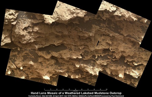
The MAHLI view on Sol 1675.
Jan van Driel
|
|
|
|
|
|
|
Apr 26 2017, 02:35 AM
Post
#50
|
|
|
Senior Member Group: Members Posts: 2430 Joined: 30-January 13 From: Penang, Malaysia. Member No.: 6853 |
|
|
|
|
|
Apr 26 2017, 03:56 AM
Post
#51
|
||
|
Senior Member Group: Members Posts: 2430 Joined: 30-January 13 From: Penang, Malaysia. Member No.: 6853 |
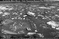
Curiosity Rover Total Traverse Passes The 10 Mile Marker
Date: 25th April 2017 (Mission Sol 1677) Total traverse: 16.12 kilometers (10.1 miles) Camera: Left-Side Navigation Camera (cropped /resized mosaic) Curiosity's Traverse Map Through Sol 1677: Link
|
|
|
|
|
|
|
Apr 26 2017, 09:11 AM
Post
#52
|
|
|
Senior Member Group: Members Posts: 2430 Joined: 30-January 13 From: Penang, Malaysia. Member No.: 6853 |
Curiosity Rover USGS Mission Update: Sol 1678: A Smooth Planning Day By Ken Herkenhoff & Lauren Edgar 25th April 2017 Link
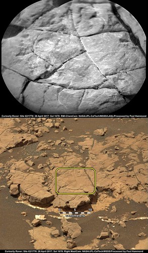
QUOTE MSL drove another 33 meters on Sol 1677, and again is surrounded by rocky outcrops partly covered by dark sand. Although Rover Planner support was available for "touch and go" contact science, the GEO science theme group decided that the limited reachable outcrop did not warrant contact science, and that driving is the top priority for this plan. APXS data were successfully acquired on Sol 1677, so are not urgently needed in this new location. The plan for Sol 1678 therefore focuses on remote sensing, with ChemCam 10x1 rasters on "Hancock Point," a darker exposure of bedrock, and "Crocker Mountain," a more normal-looking bedrock exposure. Mastcam context imaging of these targets will be followed by mosaics of nearby exposures that show sedimentary structures. Because the drive plan is likely to end up with bedrock in the arm workspace, we added a 3x2 Left Mastcam mosaic of the workspace to the post-drive imaging block, in case we can plan a touch and go tomorrow. Two ChemCam AEGIS activities and a Navcam zenith movie are planned after the drive. Thanks to the efficient work done by the science theme groups, planning went very smoothly today, making it an easy day for me as SOWG Chair.
|
|
|
|
|
Apr 26 2017, 10:23 AM
Post
#53
|
||
|
Senior Member Group: Members Posts: 2430 Joined: 30-January 13 From: Penang, Malaysia. Member No.: 6853 |
1678 partial pan L-NavCam using MS ICE, will add details when they arrive, but it looks like a good drive of at least 70 minutes
|
|
|
|
|
|
|
Apr 27 2017, 11:36 AM
Post
#54
|
||
|
Senior Member Group: Members Posts: 2430 Joined: 30-January 13 From: Penang, Malaysia. Member No.: 6853 |
Sol 1679 L-NavCam partial pan in MS ICE, drive was ~46 minutes, no other details at the moment
|
|
|
|
|
|
|
Apr 27 2017, 12:07 PM
Post
#55
|
||
|
Senior Member Group: Members Posts: 2430 Joined: 30-January 13 From: Penang, Malaysia. Member No.: 6853 |
Sol 1678 L-MastCam mosaic (arm workspace) MS-ICE
|
|
|
|
|
|
|
Apr 27 2017, 07:26 PM
Post
#56
|
||
|
Senior Member Group: Members Posts: 2842 Joined: 22-April 05 From: Ridderkerk, Netherlands Member No.: 353 |
The complete Navcam L view on Sol 1676.
Jan van Driel
|
|
|
|
|
|
|
Apr 27 2017, 08:17 PM
Post
#57
|
||
|
Senior Member Group: Members Posts: 2842 Joined: 22-April 05 From: Ridderkerk, Netherlands Member No.: 353 |
and the complete one taken on Sol 1677.
Jan van Driel
|
|
|
|
|
|
|
Apr 28 2017, 06:49 AM
Post
#58
|
|
|
Senior Member Group: Members Posts: 2430 Joined: 30-January 13 From: Penang, Malaysia. Member No.: 6853 |
|
|
|
|
|
Apr 28 2017, 02:13 PM
Post
#59
|
||
|
Senior Member Group: Members Posts: 2842 Joined: 22-April 05 From: Ridderkerk, Netherlands Member No.: 353 |
The Navcam L view on Sol 1678.
Jan van Driel
|
|
|
|
|
|
|
Apr 28 2017, 06:07 PM
Post
#60
|
||
|
Solar System Cartographer Group: Members Posts: 10197 Joined: 5-April 05 From: Canada Member No.: 227 |
Here is Jan's latest panorama in circular form.
Phil
-------------------- ... because the Solar System ain't gonna map itself.
Also to be found posting similar content on https://mastodon.social/@PhilStooke Maps for download (free PD: https://upload.wikimedia.org/wikipedia/comm...Cartography.pdf NOTE: everything created by me which I post on UMSF is considered to be in the public domain (NOT CC, public domain) |
|
|
|
|
|
|
Apr 28 2017, 08:11 PM
Post
#61
|
||
|
Senior Member Group: Members Posts: 2842 Joined: 22-April 05 From: Ridderkerk, Netherlands Member No.: 353 |
and the view, with missing data, on Sol 1679.
Jan van Driel
|
|
|
|
|
|
|
Apr 30 2017, 01:48 AM
Post
#62
|
||
|
Solar System Cartographer Group: Members Posts: 10197 Joined: 5-April 05 From: Canada Member No.: 227 |
Thanks, Jan - here is a circular view of it (I filled a little bit of the gap before projecting)
Phil
-------------------- ... because the Solar System ain't gonna map itself.
Also to be found posting similar content on https://mastodon.social/@PhilStooke Maps for download (free PD: https://upload.wikimedia.org/wikipedia/comm...Cartography.pdf NOTE: everything created by me which I post on UMSF is considered to be in the public domain (NOT CC, public domain) |
|
|
|
|
|
|
Apr 30 2017, 07:50 PM
Post
#63
|
||
|
Senior Member Group: Members Posts: 2842 Joined: 22-April 05 From: Ridderkerk, Netherlands Member No.: 353 |
The complete Navcam L view on Sol 1679.
( Added the missing image taken on Sol 1680 ) Jan van Driel
|
|
|
|
|
|
|
Apr 30 2017, 08:43 PM
Post
#64
|
||
|
Senior Member Group: Members Posts: 2842 Joined: 22-April 05 From: Ridderkerk, Netherlands Member No.: 353 |
and the view on Sol 1680.
Jan van Driel
|
|
|
|
|
|
|
May 1 2017, 09:25 PM
Post
#65
|
||
|
Senior Member Group: Members Posts: 2430 Joined: 30-January 13 From: Penang, Malaysia. Member No.: 6853 |
Partial NLB 1683, with a little data drop out. M-Planets tweeted it as approximately 25.5m SSE (151º)
|
|
|
|
|
|
|
May 2 2017, 09:04 PM
Post
#66
|
|
|
Member Group: Members Posts: 866 Joined: 15-March 05 From: Santa Cruz, CA Member No.: 196 |
|
|
|
|
|
May 3 2017, 09:09 AM
Post
#67
|
||
|
Senior Member Group: Members Posts: 2842 Joined: 22-April 05 From: Ridderkerk, Netherlands Member No.: 353 |
The Navcam L view on Sol 1684.
Jan van Driel
|
|
|
|
|
|
|
May 3 2017, 02:25 PM
Post
#68
|
|
|
Senior Member Group: Members Posts: 2430 Joined: 30-January 13 From: Penang, Malaysia. Member No.: 6853 |
|
|
|
|
|
May 3 2017, 03:49 PM
Post
#69
|
||
|
Solar System Cartographer Group: Members Posts: 10197 Joined: 5-April 05 From: Canada Member No.: 227 |
Here is your half-panorama in circular form. My map update uses this to show where we are.
Phil
-------------------- ... because the Solar System ain't gonna map itself.
Also to be found posting similar content on https://mastodon.social/@PhilStooke Maps for download (free PD: https://upload.wikimedia.org/wikipedia/comm...Cartography.pdf NOTE: everything created by me which I post on UMSF is considered to be in the public domain (NOT CC, public domain) |
|
|
|
|
|
|
May 3 2017, 07:41 PM
Post
#70
|
||
|
Senior Member Group: Members Posts: 2842 Joined: 22-April 05 From: Ridderkerk, Netherlands Member No.: 353 |
The last complete image is down and here is the Navcam L view on Sol 1683.
Jan van Driel
|
|
|
|
|
|
|
May 4 2017, 07:04 AM
Post
#71
|
||
 Senior Member Group: Members Posts: 1089 Joined: 19-February 05 From: Close to Meudon Observatory in France Member No.: 172 |
Thank you very much jvandriel for this very interesting mosaic.
What we can see inside (see your annotated image with brown lines) is that there is clearly an orientation of the layers going down the slope... Did water flow here?
|
|
|
|
|
|
|
May 4 2017, 02:39 PM
Post
#72
|
|
|
Senior Member Group: Members Posts: 2430 Joined: 30-January 13 From: Penang, Malaysia. Member No.: 6853 |
|
|
|
|
|
May 4 2017, 07:33 PM
Post
#73
|
||
|
Senior Member Group: Members Posts: 2842 Joined: 22-April 05 From: Ridderkerk, Netherlands Member No.: 353 |
The Navcam L View on Sol 1685.
Jan van Driel
|
|
|
|
|
|
|
May 4 2017, 09:53 PM
Post
#74
|
|||||
|
Member Group: Members Posts: 866 Joined: 15-March 05 From: Santa Cruz, CA Member No.: 196 |
anaglph and crosseye excerpt of stitches of the outcrop images on sol1684 M-34 and sol1685 M-100. plus one from the navcam view on sol1685
|
||||
|
|
|
||||
|
May 5 2017, 12:04 AM
Post
#75
|
||
|
Solar System Cartographer Group: Members Posts: 10197 Joined: 5-April 05 From: Canada Member No.: 227 |
This is Jan's 1685 panorama in circular form, filling out the rest of the circle compared with the half-panorama posted earlier.
Phil
-------------------- ... because the Solar System ain't gonna map itself.
Also to be found posting similar content on https://mastodon.social/@PhilStooke Maps for download (free PD: https://upload.wikimedia.org/wikipedia/comm...Cartography.pdf NOTE: everything created by me which I post on UMSF is considered to be in the public domain (NOT CC, public domain) |
|
|
|
|
|
|
May 5 2017, 10:26 AM
Post
#76
|
||
|
Senior Member Group: Members Posts: 2842 Joined: 22-April 05 From: Ridderkerk, Netherlands Member No.: 353 |
The Navcam L view on Sol 1686.
Jan van Driel
|
|
|
|
|
|
|
May 5 2017, 01:28 PM
Post
#77
|
|
 Junior Member Group: Members Posts: 21 Joined: 21-August 12 From: the Netherlands Member No.: 6599 |
Thanks 4 the great pictures Jan, Paul, Phil, atom et al.
-------------------- ---------------------------------------------------------- Gale is a Crater filled by Volcano M.Sharp ----------------------------------------------------------- |
|
|
|
|
May 5 2017, 02:03 PM
Post
#78
|
|
|
Member Group: Members Posts: 122 Joined: 19-June 07 Member No.: 2455 |
I see that we're ascending a hill because the view of the base of Mt. Sharp is really obstructed and has been for awhile. How much more distance do we have to go before we crest this rise?
|
|
|
|
|
May 5 2017, 06:57 PM
Post
#79
|
||
|
Solar System Cartographer Group: Members Posts: 10197 Joined: 5-April 05 From: Canada Member No.: 227 |
Jan's sol 1686 panorama in circular form. Compare with the previous one to see how we moved down the SW side of the linear megaripple.
Phil
-------------------- ... because the Solar System ain't gonna map itself.
Also to be found posting similar content on https://mastodon.social/@PhilStooke Maps for download (free PD: https://upload.wikimedia.org/wikipedia/comm...Cartography.pdf NOTE: everything created by me which I post on UMSF is considered to be in the public domain (NOT CC, public domain) |
|
|
|
|
|
|
May 5 2017, 09:59 PM
Post
#80
|
|
 Senior Member Group: Members Posts: 1656 Joined: 5-March 05 From: Boulder, CO Member No.: 184 |
QUOTE (Art Martin @ May 5 2017, 02:03 PM) I see that we're ascending a hill because the view of the base of Mt. Sharp is really obstructed and has been for awhile. How much more distance do we have to go before we crest this rise? It seems most of the rest of the mission will be on a similar slope up Mt. Sharp. -------------------- Steve [ my home page and planetary maps page ]
|
|
|
|
|
May 6 2017, 03:13 AM
Post
#81
|
||
|
Senior Member Group: Members Posts: 2430 Joined: 30-January 13 From: Penang, Malaysia. Member No.: 6853 |
QUOTE (Art Martin @ May 5 2017, 10:03 PM) I see that we're ascending..... This may help Note the vertical dimension is exaggerated 14-fold... Full report Link
|
|
|
|
|
|
|
May 6 2017, 11:17 PM
Post
#82
|
|
|
Member Group: Members Posts: 122 Joined: 19-June 07 Member No.: 2455 |
QUOTE (PaulH51 @ May 5 2017, 08:13 PM) This may help Thank you. Wow, the views should be spectacular. |
|
|
|
|
May 7 2017, 12:38 AM
Post
#83
|
|
|
Member Group: Members Posts: 122 Joined: 19-June 07 Member No.: 2455 |
Some 3D from Sol 1686
 1686 Ripples Anaglyph 2 1686 Ripples Anaglyph 2 1686 Ripples Side By Side 2 1686 Ripples Side By Side 2 1686 Ripples Anaglyph 1686 Ripples Anaglyph 1686 Ripples Side By Side 1686 Ripples Side By Side Panorama Anaglyph by Art Martin, on Flickr Panorama Anaglyph by Art Martin, on Flickr
|
|
|
|
|
May 7 2017, 02:24 AM
Post
#84
|
||
|
Senior Member Group: Members Posts: 2430 Joined: 30-January 13 From: Penang, Malaysia. Member No.: 6853 |
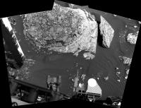
Sol 1682 : A mosaic of focus merged MAHLIs assembled in MS ICE (the base images were acquired one sol earlier)
Scale from focus motor count using Gerald's MAHLI Ruler
|
|
|
|
|
|
|
May 7 2017, 10:42 AM
Post
#85
|
|
|
Senior Member Group: Members Posts: 2430 Joined: 30-January 13 From: Penang, Malaysia. Member No.: 6853 |
|
|
|
|
|
May 8 2017, 03:17 AM
Post
#86
|
||
|
Senior Member Group: Members Posts: 2430 Joined: 30-January 13 From: Penang, Malaysia. Member No.: 6853 |
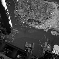
Sol 1688: a crop from a mosaic of two R-MastCam frames looking WSW of the rover. Assembled in MS ICE, scale bar added using AlgorimancerPG which placed the large block at ~15 m from the camera, contrast stretched.
|
|
|
|
|
|
|
May 8 2017, 10:11 AM
Post
#87
|
|
|
Senior Member Group: Members Posts: 1074 Joined: 21-September 07 From: Québec, Canada Member No.: 3908 |
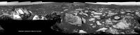
The complete sol 1688 Rmastcam panorama:
|
|
|
|
|
May 9 2017, 12:52 AM
Post
#88
|
||
|
Senior Member Group: Members Posts: 2430 Joined: 30-January 13 From: Penang, Malaysia. Member No.: 6853 |
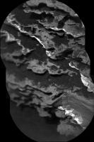
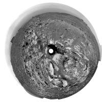
1690 L-NavCam: Quick & very dirty in MS ICE, but it's a full 360 and may suffice until Jan can do his magic. We appear to have the right rear wheel close to the small outcrop featured in my last post, Edit JPL show the drive to be a tad over 11 meters. We have now reached site 63
50% preview and link (below) to the full resolution pan on Imgur
Full resolution pan LINK |
|
|
|
|
|
|
May 9 2017, 01:27 AM
Post
#89
|
||
|
Solar System Cartographer Group: Members Posts: 10197 Joined: 5-April 05 From: Canada Member No.: 227 |
Paul's panorama in a circular version - I cropped out the horizon, which had a few defects in it that are magnified by my reprojection method.
Phil
-------------------- ... because the Solar System ain't gonna map itself.
Also to be found posting similar content on https://mastodon.social/@PhilStooke Maps for download (free PD: https://upload.wikimedia.org/wikipedia/comm...Cartography.pdf NOTE: everything created by me which I post on UMSF is considered to be in the public domain (NOT CC, public domain) |
|
|
|
|
|
|
May 9 2017, 04:56 PM
Post
#90
|
||
|
Senior Member Group: Members Posts: 2842 Joined: 22-April 05 From: Ridderkerk, Netherlands Member No.: 353 |
The Navcam L view on Sol 1690.
Jan van Driel
|
|
|
|
|
|
|
May 9 2017, 06:29 PM
Post
#91
|
|||
|
Solar System Cartographer Group: Members Posts: 10197 Joined: 5-April 05 From: Canada Member No.: 227 |
Sol 1691 - a short drive, just a few metres, southwestish. Here are the reprojected Hazcams and my recent circular image showing the drive very roughly - map update tonight.
Phil
-------------------- ... because the Solar System ain't gonna map itself.
Also to be found posting similar content on https://mastodon.social/@PhilStooke Maps for download (free PD: https://upload.wikimedia.org/wikipedia/comm...Cartography.pdf NOTE: everything created by me which I post on UMSF is considered to be in the public domain (NOT CC, public domain) |
||
|
|
|
||
|
May 9 2017, 08:34 PM
Post
#92
|
||||
|
Member Group: Members Posts: 866 Joined: 15-March 05 From: Santa Cruz, CA Member No.: 196 |
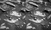
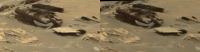
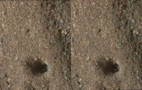
layer flake stereo of sol1688, presumably one of the '_Brook' vein targets. I'm not sure what the story is with that 'hole' apparently punched in the distressed area with Mahli pin chevrons apparently dragged behind.. the visible Z-offset stripes perhaps due to scan differences in the images being overlaid and made apparent in the stereo, the Mahli frame maybe crept a bit during exposure due to MSL settling?
|
|||
|
|
|
|||
|
May 9 2017, 10:10 PM
Post
#93
|
|
|
Senior Member Group: Members Posts: 4252 Joined: 17-January 05 Member No.: 152 |
QUOTE (atomoid @ May 9 2017, 09:34 PM) the visible Z-offset stripes perhaps due to scan differences in the images being overlaid and made apparent in the stereo, the Mahli frame maybe crept a bit during exposure due to MSL settling? If those are focus stacks, that's the kind of thing you expect since the process combines parts of the various images with the best focus. The original images shouldn't show those effects. |
|
|
|
|
May 9 2017, 10:45 PM
Post
#94
|
|
|
Solar System Cartographer Group: Members Posts: 10197 Joined: 5-April 05 From: Canada Member No.: 227 |
"I'm not sure what the story is with that 'hole' apparently punched in the distressed area with Mahli pin chevrons apparently dragged behind.. "
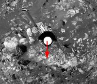
That's no MAHLI pin chevron! Those are ChemCam pits in sand, made the day before: http://www.midnightplanets.com/web/MSL/ima...CAM02687L1.html Each new blast pushes sand into the previous pit (each pit is the sum of numerous zaps with the laser). Phil -------------------- ... because the Solar System ain't gonna map itself.
Also to be found posting similar content on https://mastodon.social/@PhilStooke Maps for download (free PD: https://upload.wikimedia.org/wikipedia/comm...Cartography.pdf NOTE: everything created by me which I post on UMSF is considered to be in the public domain (NOT CC, public domain) |
|
|
|
|
May 10 2017, 03:08 AM
Post
#95
|
||
|
Solar System Cartographer Group: Members Posts: 10197 Joined: 5-April 05 From: Canada Member No.: 227 |
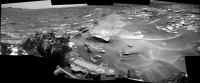
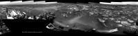
This is Jan's panorama from sol 1690 in circular form. It's basically the same as Paul's except I took it out to the horizon. We get a good view of the geography of the site. The Murray Buttes are just becoming visible again - they had disappeared behind the local horizon for a while but as we climb they are reappearing.
Phil
-------------------- ... because the Solar System ain't gonna map itself.
Also to be found posting similar content on https://mastodon.social/@PhilStooke Maps for download (free PD: https://upload.wikimedia.org/wikipedia/comm...Cartography.pdf NOTE: everything created by me which I post on UMSF is considered to be in the public domain (NOT CC, public domain) |
|
|
|
|
|
|
May 10 2017, 11:30 AM
Post
#96
|
||
|
Senior Member Group: Members Posts: 2842 Joined: 22-April 05 From: Ridderkerk, Netherlands Member No.: 353 |
The Navcam L view on Sol 1691.
Jan van Driel
|
|
|
|
|
|
|
May 10 2017, 12:04 PM
Post
#97
|
||
|
Senior Member Group: Members Posts: 2430 Joined: 30-January 13 From: Penang, Malaysia. Member No.: 6853 |
One of a series of pre-drive focus merged MAHLI's from sol 1691. A 30 millimeter scale has been bar added (based on the focus motor count reported for the first image then using Gerald's MAHLI Ruler)
Other MAHLI's from 1691 LINK |
|
|
|
|
|
|
May 10 2017, 02:15 PM
Post
#98
|
|
|
Senior Member Group: Members Posts: 2346 Joined: 7-December 12 Member No.: 6780 |
For the focus-stacked images, the motor count for the first image may be well off-focus. In this case, the motor count of the first image of the stacked image is 13722, while it is 13916 for a sharp similar single image.
Whenever the scale is essential for an investigation, I'd recommend to work with single unstacked images, and apply the scale to the sharpest areas. |
|
|
|
|
May 10 2017, 11:05 PM
Post
#99
|
|
|
Senior Member Group: Members Posts: 2430 Joined: 30-January 13 From: Penang, Malaysia. Member No.: 6853 |
QUOTE (Gerald @ May 10 2017, 10:15 PM) I'd recommend to work with single unstacked images, and apply the scale to the sharpest areas. Thanks Gerald |
|
|
|
|
May 10 2017, 11:14 PM
Post
#100
|
||
|
Senior Member Group: Members Posts: 2430 Joined: 30-January 13 From: Penang, Malaysia. Member No.: 6853 |
1691 L-MastCam of Curiosity's workspace, assembled in MS ICE, scaled using AlgorimancerPG. Reduced size posted here, LINK to full resolution on IMGUR
|
|
|
|
|
|
 |

|
Lo-Fi Version | Time is now: 24th June 2024 - 04:42 PM |
|
RULES AND GUIDELINES Please read the Forum Rules and Guidelines before posting. IMAGE COPYRIGHT |
OPINIONS AND MODERATION Opinions expressed on UnmannedSpaceflight.com are those of the individual posters and do not necessarily reflect the opinions of UnmannedSpaceflight.com or The Planetary Society. The all-volunteer UnmannedSpaceflight.com moderation team is wholly independent of The Planetary Society. The Planetary Society has no influence over decisions made by the UnmannedSpaceflight.com moderators. |
SUPPORT THE FORUM Unmannedspaceflight.com is funded by the Planetary Society. Please consider supporting our work and many other projects by donating to the Society or becoming a member. |
|