To the Cape!, Quackmire and arm troubles |

To the Cape!, Quackmire and arm troubles |
 Mar 31 2008, 12:16 PM Mar 31 2008, 12:16 PM
Post
#1
|
|
|
Founder  Group: Chairman Posts: 14433 Joined: 8-February 04 Member No.: 1 |
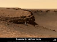
"Hey folks! Im on-duty with Opportunity this week and its going to be pretty exciting. We are in the process of driving the rover over to the wall of Cape Verde to study the layers of rocks there in much greater detail. I will be posting updates all week with the spectacular new pictures that we should be receiving. Stay tuned, its going to be a pretty cool week!"
Thanks for the update Ryan : http://martianchronicles.wordpress.com/200...ng-to-the-cape/ I wonder how close they'll get. I think no closer than the height projected from it's base ( i.e. 45 degrees ) |
 |
 
|
 |
|
Mar 31 2008, 12:34 PM
Post
#2
|
|
|
Merciless Robot Group: Admin Posts: 8784 Joined: 8-December 05 From: Los Angeles Member No.: 602 |
Rock on!!!
 
-------------------- A few will take this knowledge and use this power of a dream realized as a force for change, an impetus for further discovery to make less ancient dreams real.
|
|
|
|
|
Mar 31 2008, 12:45 PM
Post
#3
|
|
 The Poet Dude Group: Moderator Posts: 5551 Joined: 15-March 04 From: Kendal, Cumbria, UK Member No.: 60 |
Woohoo!! Go get 'em Oppy!
About time our gal lifted her eyes off the ground and looked up again. 
-------------------- |
|
|
|
|
Mar 31 2008, 01:00 PM
Post
#4
|
||
|
Senior Member Group: Members Posts: 2837 Joined: 22-April 05 From: Ridderkerk, Netherlands Member No.: 353 |
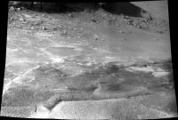
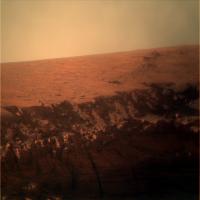
The view in the drive direction on Sol 1484.
Taken with the R2 Pancam. jvandriel
|
|
|
|
|
|
|
Mar 31 2008, 03:00 PM
Post
#5
|
|
|
Member Group: Members Posts: 279 Joined: 19-August 07 Member No.: 3299 |
QUOTE (djellison @ Mar 31 2008, 07:16 AM)  I wonder how close they'll get. I think no closer than the height projected from it's base ( i.e. 45 degrees )
Why do you think that Opportunity won't be closer than the distance of the height of wall? |
|
|
|
|
Mar 31 2008, 03:44 PM
Post
#6
|
|
|
Founder Group: Chairman Posts: 14433 Joined: 8-February 04 Member No.: 1 |
QUOTE (SpaceListener @ Mar 31 2008, 04:00 PM) Why do you think that Opportunity won't be closer than the distance of the height of wall? Restricted visibility for Mars Odyssey communications. You would probably be taking a 1/3rd off total downlink if you brought the local horizon to 45 deg elevation (given that the spacecraft will appear to move slower nearer the horizon, thus more of the session, and thus the data, is sent at the lower elevations. ) Doug |
|
|
|
|
Mar 31 2008, 04:28 PM
Post
#7
|
|
|
Senior Member Group: Members Posts: 3516 Joined: 4-November 05 From: North Wales Member No.: 542 |
I'm probably missing something very simple here, but how long does it take to take a photo? Why can't they do short in-out maneuvers for the close-up snaps, backing out each time to a better location for sunbathing and data transmission?
|
|
|
|
|
Mar 31 2008, 08:19 PM
Post
#8
|
|
 Member Group: Members Posts: 753 Joined: 23-October 04 From: Greensboro, NC USA Member No.: 103 |
QUOTE (ngunn @ Mar 31 2008, 11:28 AM) I'm probably missing something very simple here, but how long does it take to take a photo? Why can't they do short in-out maneuvers for the close-up snaps, backing out each time to a better location for sunbathing and data transmission? The problem would be if something unexpected happened that aborted the drive-away, anything from wheel slippage to a 'safe mode' event. That could potentially strand Oppy in a very bad place and the situation could deteriorate rapidly if there wasn't enough sunlight or ability to 'see' the orbiters. -------------------- Jonathan Ward
Manning the LCC at http://www.apollolaunchcontrol.com |
|
|
|
|
Mar 31 2008, 08:29 PM
Post
#9
|
|
|
Senior Member Group: Members Posts: 2922 Joined: 14-February 06 From: Very close to the Pyrénées Mountains (France) Member No.: 682 |
When I sew the title of this new topic (I din't notice it was in Oppy section) I thought : I do not remember of any launch scheduled at Cape ...Canaveral !
After last week news of nearly shutting the rovers down...it's even a much better new ! -------------------- |
|
|
|
|
Mar 31 2008, 09:06 PM
Post
#10
|
|
|
Senior Member Group: Members Posts: 3516 Joined: 4-November 05 From: North Wales Member No.: 542 |
QUOTE (ilbasso @ Mar 31 2008, 09:19 PM) The problem would be if something unexpected happened that aborted the drive-away A finite risk, certainly, but maybe manageable. I guess you'd have to do repeated stabs to and fro along the same track going a little further in each time, with the back-outs at the far end being slightly downhill (which they probably would be anyway). I doubt if the total daily insolation anywhere (in fine weather) would be as bad as it was out on the plain during the dust storm, and if you're just edging cautiously out of trouble as opposed to sending lots of data you don't need that much relay time. If it's the only way to address a major science objective some risk is maybe worthwhile? |
|
|
|
|
Apr 1 2008, 04:42 AM
Post
#11
|
|
 Senior Member Group: Members Posts: 2228 Joined: 1-December 04 From: Marble Falls, Texas, USA Member No.: 116 |
Thanks, Ryan, for the heads-up on this week's plans.
With regard to how closely Opportunity might approach the cliffs of Cape Verde, I think the local geomorphology also limits the places where Oppy is likely to tread. I would guess that the toe of the talus slope surrounding Cape Verde is a boundary beyond which this rover is unlikely to stray. -------------------- ...Tom
I'm not a Space Fan, I'm a Space Exploration Enthusiast. |
|
|
|
|
Apr 1 2008, 07:37 AM
Post
#12
|
|
|
Founder Group: Chairman Posts: 14433 Joined: 8-February 04 Member No.: 1 |
"We're hoping to get close enough to reach out and touch the face of this cliff,"
Squyres, in the TPS Rover update for March. Mr conservative here got it wrong. |
|
|
|
|
Apr 1 2008, 08:33 AM
Post
#13
|
|
|
Senior Member Group: Moderator Posts: 4279 Joined: 19-April 05 From: .br at .es Member No.: 253 |
Great news IMO!
(I was planning to post the exact same piece of info. Doug, you beat me.) "Opportunity roved the first 5.5 meters (18 feet) of the journey to Cape Verde on Sol 1484 (last Thursday, March 27, 2008) and followed that with another 5 meter (16.4-foot) drive on Sol 1486 Saturday (March 29, 2008)" Next drive is planned for sol 1489. Images should be down in less then 24h. |
|
|
|
|
Apr 1 2008, 10:50 AM
Post
#14
|
|
|
Senior Member Group: Members Posts: 2922 Joined: 14-February 06 From: Very close to the Pyrénées Mountains (France) Member No.: 682 |
So, this is the "surprise" SS talked about a few weeks ago! I like it
-------------------- |
|
|
|
|
Apr 2 2008, 12:53 AM
Post
#15
|
||
 Senior Member Group: Members Posts: 4252 Joined: 17-January 05 Member No.: 152 |
I like it too! And can't believe the "reach out and touch" line. At first I thought: "April fools?"
Based on the blog report, here's my estimate of the target location (enhanced and cropped from a pan posted by CosmicRocker):
I can understand the drooling going on contemplating that layering! |
|
|
|
|
|
|
Apr 2 2008, 02:40 AM
Post
#16
|
|
|
Member Group: Members Posts: 307 Joined: 16-March 05 Member No.: 198 |
QUOTE (djellison @ Mar 31 2008, 11:16 PM) I wonder how close they'll get. I think no closer than the height projected from it's base ( i.e. 45 degrees ) There is a quote from Steve Squyres in the latest MER update on planetary.org which relates to this: "'We're hoping to get close enough to reach out and touch the face of this cliff,' Squyres said Friday. There are a number of things that make that 'kind of scary,' he said. 'One is that there is a very steep and rocky slope right below the cliff and those are always difficult to maneuver on.'" ====== Stephen Edit: I might add there one or two other tidbits about the Cape Verde adventure in that planetary.org page people might want to check out. |
|
|
|
|
Apr 2 2008, 03:30 AM
Post
#17
|
|
 Senior Member Group: Members Posts: 3419 Joined: 9-February 04 From: Minneapolis, MN, USA Member No.: 15 |
Well... after the number of times I have suggested that Squyres and company might well decide to trundle over to the rock face at Verde, and the equal number of times I've been told that it'll *never* happen, I feel good about the plans right now...
 -the other Doug -------------------- The trouble ain't that there is too many fools, but that the lightning ain't distributed right. -Mark Twain
|
|
|
|
|
Apr 2 2008, 04:06 AM
Post
#18
|
|
|
Member Group: Members Posts: 233 Joined: 21-April 05 Member No.: 328 |
"Here's an obvious scenario that better minds can critique: we will descend hugging the clockwise cliff but also at some safe distance from it (lest a rock should become dislodged during the next wind event or daily thermal cycle and fall on the solar panels), occasionally turning to face it (but still at some safe distance) and using the full reach of the instrument arm to RAT and take micrographs and readings." This from my post of June 24, 2007 starting "The Descent into Victoria" thread, before the sandstorm etc. intervened. As noted, an obvious scenario -- you just have to have a little patience!
|
|
|
|
|
Apr 2 2008, 06:14 AM
Post
#19
|
|
|
Senior Member Group: Members Posts: 2228 Joined: 1-December 04 From: Marble Falls, Texas, USA Member No.: 116 |
QUOTE (fredk @ Apr 1 2008, 06:53 PM) ... Based on the blog report, here's my estimate of the target location ... That would be my choice, too. It appears to be the part of the layered cliff face that can be approached to within an IDD-distance, while avoiding most of the talus and wind-blown sediment. It also is a place where daily sunshine and satellite communications should be minimally affected. I liked this SS quotation..."For now, all eyes at Meridiani are on the base of Cape Verde. The stereo images the rover took of this "promontory" from the rim last year show striking layers within the bedrock. "The Pancam image we're going to take once we get into position at the base is going to be just stunning, like nothing you've ever seen," Squyres promised. I can hardly wait.
-------------------- ...Tom
I'm not a Space Fan, I'm a Space Exploration Enthusiast. |
|
|
|
|
Apr 2 2008, 02:19 PM
Post
#20
|
||
|
Senior Member Group: Members Posts: 2837 Joined: 22-April 05 From: Ridderkerk, Netherlands Member No.: 353 |
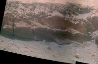
The view in the drive direction on Sol 1486.
Taken with the R0 Navcam. jvandriel
|
|
|
|
|
|
|
Apr 2 2008, 02:54 PM
Post
#21
|
|
|
Senior Member Group: Members Posts: 4252 Joined: 17-January 05 Member No.: 152 |
Testing the surface, I suppose:
http://qt.exploratorium.edu/mars/opportuni...76P1212L0M1.JPG |
|
|
|
|
Apr 2 2008, 11:12 PM
Post
#22
|
|
|
Solar System Cartographer Group: Members Posts: 10189 Joined: 5-April 05 From: Canada Member No.: 227 |
That looks a bit too loose for my liking.
Phil -------------------- ... because the Solar System ain't gonna map itself.
Also to be found posting similar content on https://mastodon.social/@PhilStooke Maps for download (free PD: https://upload.wikimedia.org/wikipedia/comm...Cartography.pdf NOTE: everything created by me which I post on UMSF is considered to be in the public domain (NOT CC, public domain) |
|
|
|
|
Apr 3 2008, 12:38 AM
Post
#23
|
|||
 Senior Member Group: Admin Posts: 3108 Joined: 21-December 05 From: Canberra, Australia Member No.: 615 |
EDITED - I received some feedback which said... "We are aiming for the triangular piece of layered bedrock that is just to the right of Oppy in your picture. Given the shadows we have seen on images taken on Sol 1489 we might not be able to get so close, but we will try."
OK, Opportunity getting to the base of Cape Verde is just too tempting an image to not start looking at producing an artist's view. Here's my
Revised image based on the advice above. This will form part of a wider panorama that I am still working on, but the file will be about 25mb when I'm finished. Here's a small preview.
Enjoy Astro0 |
||
|
|
|
||
|
Apr 3 2008, 01:40 AM
Post
#24
|
|
 Senior Member Group: Members Posts: 1229 Joined: 24-December 05 From: The blue one in between the yellow and red ones. Member No.: 618 |
Astro0, Old Matey, Why don't you make a movie 'short' of Oppy puttering around Duck Bay, with the clouds rolling by and a suitable sound track?
On a more serious note, I wonder if someone could do a precise calculation of Oppy's daily solar energy intake in that near-wall position. I fear the result would be disconcerting! -------------------- My Grandpa goes to Mars every day and all I get are these lousy T-shirts!
|
|
|
|
|
Apr 3 2008, 06:22 AM
Post
#25
|
|
|
Member Group: Members Posts: 233 Joined: 21-April 05 Member No.: 328 |
Yes, the approach looks a little dicey! (How's that for Brit speak?!?)
|
|
|
|
|
Apr 3 2008, 01:58 PM
Post
#26
|
|
|
Senior Member Group: Members Posts: 4252 Joined: 17-January 05 Member No.: 152 |
We're well past the equinox now, heading towards northern summer. That means that for Oppy, near the equator, the sun has to be on the northern half of the sky all day. It would rise in the ENE, climb up high in the north, and set in the WNW. Definitely not optimal.
Power is one issue, but I wonder what the imaging will be like for shadowed targets. I would think longer than usual exposures would work well. I can't recall any closeup imaging of large shadowed regions from either rover before. |
|
|
|
|
Apr 3 2008, 02:43 PM
Post
#27
|
|
|
Founder Group: Chairman Posts: 14433 Joined: 8-February 04 Member No.: 1 |
Oh, hold on - you're right. An equatorial site, during northern summer, will have the sun in the north at noon. At high summer, it would be 25 degrees from zenith. Thus - at noon, mid summers day, a 10m cliff would cast a shadow of about 4.6 metres.
So shadowing WILL be an issue (as indeed, the 4pm navcam image taken a few sols ago shows) I've got it right this time havn't I? Equatorial sites would have the sun at zenith during northern spring and autumn, and then experience two winters as it were, at northern summer (when a site 25 deg north of the equator has the sun at zenith) and northern winter ( when a site 25 deg south of the equator has the sun at senith) Doug |
|
|
|
|
Apr 3 2008, 04:25 PM
Post
#28
|
|
|
Senior Member Group: Members Posts: 4252 Joined: 17-January 05 Member No.: 152 |
That's right, two very mild winters.
Does anyone know the current subsolar latitude on Mars? Equinox was Dec 10th, solstice is June 25th, so we're past halfway to solstice, but the sun moves northwards much more quickly near equinox, so I'd guess that the sun at noon is currently between 15 and 20 degrees to the north of zenith for Oppy. |
|
|
|
|
Apr 3 2008, 05:11 PM
Post
#29
|
|
 Administrator Group: Admin Posts: 5172 Joined: 4-August 05 From: Pasadena, CA, USA, Earth Member No.: 454 |
The current subsolar latitude is roughly 20 deg north (this is from Mars24).
Edit: And the current solar elevation for Opportuity is 67.7 degrees. --Emily -------------------- My website - My Patreon - @elakdawalla on Twitter - Please support unmannedspaceflight.com by donating here.
|
|
|
|
|
Apr 3 2008, 06:00 PM
Post
#30
|
|
 Dublin Correspondent Group: Admin Posts: 1799 Joined: 28-March 05 From: Celbridge, Ireland Member No.: 220 |
Sunrise\sunset (on the plains) is at around 5:55AM local mars time at the moment and on a typical Sol the percentages of the the total amount of power generated per hour of each sol is [very roughly]:
12-1PM:15% 1-2PM:13% 2-3PM:11% 3-4PM:7% 4-5PM:3% 5-6PM:1% (similar numbers apply in reverse to the morning) My take would be that they could risk being in the shade of the cape for quite a few hours in the evening without it being too risky in terms of overall power loss, being in shade from 3PM would only lose 10-11% of total daily power. It might have a significant impact on thermal management though which is something to bear in mind. |
|
|
|
|
Apr 3 2008, 07:03 PM
Post
#31
|
|
|
Senior Member Group: Members Posts: 1229 Joined: 24-December 05 From: The blue one in between the yellow and red ones. Member No.: 618 |
Presumably Oppy would be in full shadow all morning, until some time around local noon. Do we have an estimated power input during this shadowed period? Then how many hours of direct sunlight would follow before shadow re-covered it? Can we estimate the southerly tilt of the solar arrays in the near-wall position?
-------------------- My Grandpa goes to Mars every day and all I get are these lousy T-shirts!
|
|
|
|
|
Apr 3 2008, 08:00 PM
Post
#32
|
|
|
Senior Member Group: Members Posts: 2922 Joined: 14-February 06 From: Very close to the Pyrénées Mountains (France) Member No.: 682 |
You all love calculations. I love pictures
  : : Let them take pictures of the place they want to go at different hours of the day. Would be nice, eh ? -------------------- |
|
|
|
|
Apr 3 2008, 08:27 PM
Post
#33
|
|
|
Senior Member Group: Members Posts: 1229 Joined: 24-December 05 From: The blue one in between the yellow and red ones. Member No.: 618 |
A start has been made, courtesy of HHAW, for your edification, Climb: Shadow animation
However, we need watt-hour numbers to judge the hazard of a given location. -------------------- My Grandpa goes to Mars every day and all I get are these lousy T-shirts!
|
|
|
|
|
Apr 3 2008, 10:24 PM
Post
#34
|
||
|
Senior Member Group: Admin Posts: 3108 Joined: 21-December 05 From: Canberra, Australia Member No.: 615 |
That's some drive ahead of Oppy.
Anyone want to pick the route? Astro0 |
|
|
|
|
|
|
Apr 3 2008, 11:08 PM
Post
#35
|
|
|
Founder Group: Chairman Posts: 14433 Joined: 8-February 04 Member No.: 1 |
QUOTE (Astro0 @ Apr 3 2008, 11:24 PM) Anyone want to pick the route? left 40 go 10 right 90 go 5 end MER works like a LOGO turtle right? Doug |
|
|
|
|
Apr 4 2008, 12:05 AM
Post
#36
|
|
|
Dublin Correspondent Group: Admin Posts: 1799 Joined: 28-March 05 From: Celbridge, Ireland Member No.: 220 |
Judging by Horton's animation it seems that the Oppy's Solar panel deck is effectively already in shadow by 4:30-5:00PM local time. That makes sense as it is at around a 15 degree incline facing away from the setting sun which would correspond to about an hour or so of sunlight.
The shaded zone at Midday seems to be pretty close to the wall so I think that they can probably manoeuvre fairly close in and keep the rover in direct sunlight until ~3:00PM without too much trouble. That would keep the power impact below about a 5-7% reduction from the levels it currently achieves. |
|
|
|
|
Apr 4 2008, 03:07 AM
Post
#37
|
|||
|
Senior Member Group: Admin Posts: 3108 Joined: 21-December 05 From: Canberra, Australia Member No.: 615 |
Here's a revised version (third) of Oppy at Cape Verde based on some advice and a target.
The path is just my artist's thoughts, not actual. The position of the rover could be in a variety of orientations. Not science, just art
Here's the revised panorama as a thumbnail. Large version will come once Oppy arrives at the Cape.
Enjoy Astro0 |
||
|
|
|
||
|
Apr 4 2008, 03:12 AM
Post
#38
|
||
|
Senior Member Group: Admin Posts: 3108 Joined: 21-December 05 From: Canberra, Australia Member No.: 615 |
Based on the above...here's where we could be headed.
Some fantastic layering for Oppy's eyes  and ours and ours  to bug out on. to bug out on.
Cool Astro0 |
|
|
|
|
|
|
Apr 4 2008, 03:32 AM
Post
#39
|
|
|
Member Group: Members Posts: 258 Joined: 22-December 06 Member No.: 1503 |
If Oppy can actually get that close to the Cape safely, then it should be the highlight of the entire mission at Meridiani.
BTW, I would also like to see the rover traverse lower to inspect the deepest layers. I don't know whether that's possible because of the results of that test drive over the dust layer the other day. It looks like Oppy could safely get down to the lower levels, but I don't think it could make it back up the slope along that dust layer. Perhaps it could if it traverse in a Zig-Zag shaped route. I don't know. I hope the MER team finds a way to do it. |
|
|
|
|
Apr 4 2008, 03:44 AM
Post
#40
|
|
|
Merciless Robot Group: Admin Posts: 8784 Joined: 8-December 05 From: Los Angeles Member No.: 602 |
QUOTE (MarsIsImportant @ Apr 3 2008, 08:32 PM) Perhaps it could if it traverse in a Zig-Zag shaped route. I don't know. I hope the MER team finds a way to do it. Yeah, I have the same concerns...that deep. loose soil is scary to the nth. Good thought on the zigzags, though. I'm assuming that the development team at some point determined sideslip coefficients? Would be interesting to know what the limits might be as a function of tilt angle, but they're probably predicated on a more rigid surface... 
-------------------- A few will take this knowledge and use this power of a dream realized as a force for change, an impetus for further discovery to make less ancient dreams real.
|
|
|
|
|
Apr 4 2008, 08:42 AM
Post
#41
|
|
|
Senior Member Group: Members Posts: 1870 Joined: 20-February 05 Member No.: 174 |
I have not heard *anything* regarding the terrain handling ability of MSL vs MER's. Maximum slope up/down, maximum slope along-slope, soft-sand/dust, etc.
Of course, MSL should be able to handle dust that would be up to or over MER's hubcaps... it's hubcaps are higher!... but what's it's ability in proportionately deeper dust/sand? Future missions will more and more need greater terrain handling capabilities beyond the baseline level of MSL and MER. Even if a wheel fails, as on Sprit, it should be possible to convert it to a free-wheeling mode, and not terribly cripple the rover on slopes or in soft terrain. |
|
|
|
|
Apr 4 2008, 09:00 AM
Post
#42
|
|||
|
The Poet Dude Group: Moderator Posts: 5551 Joined: 15-March 04 From: Kendal, Cumbria, UK Member No.: 60 |
Going to have to tip-toe through this lot... should be some gorgeous pictures in the days and weeks ahead tho!
-------------------- |
||
|
|
|
||
|
Apr 4 2008, 09:29 AM
Post
#43
|
||
|
Senior Member Group: Moderator Posts: 4279 Joined: 19-April 05 From: .br at .es Member No.: 253 |
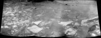
QUOTE (nprev @ Apr 4 2008, 05:44 AM) Yeah, I have the same concerns...that deep. loose soil is scary to the nth. I'm of the same opinion. But if you have a look to today's lot of hazcam images, my felling is that the rover drivers don't share our same concerns. Opportunity drove straight down the slope over the scuff.Here's tosol's (1491) navcam mosaic.
|
|
|
|
|
|
|
Apr 4 2008, 12:38 PM
Post
#44
|
|
 Member Group: Members Posts: 276 Joined: 11-December 07 From: Dar es Salaam, Tanzania Member No.: 3978 |
You hav to admit, cape verde is a compelling target. I would be interested to see the layers up close. Particularly those filled fractures. BTW any news on the status of the mini-tes on Oppy?
-------------------- |
|
|
|
|
Apr 4 2008, 06:28 PM
Post
#45
|
|
 Senior Member Group: Moderator Posts: 2262 Joined: 9-February 04 From: Melbourne - Oz Member No.: 16 |
This is just the start of the sol 1487 pan but as it shows the region we're all interested in I thought I'd process what is down so far.
 Click image James -------------------- |
|
|
|
|
Apr 4 2008, 07:16 PM
Post
#46
|
|
 Special Cookie Group: Members Posts: 2168 Joined: 6-April 05 From: Sintra | Portugal Member No.: 228 |
Great blog, great pan! Looks like you'll have a lot of work in the coming days...
-------------------- "Ride, boldly ride," The shade replied, "If you seek for Eldorado!"
Edgar Alan Poe |
|
|
|
|
Apr 5 2008, 11:45 PM
Post
#47
|
||
|
The Poet Dude Group: Moderator Posts: 5551 Joined: 15-March 04 From: Kendal, Cumbria, UK Member No.: 60 |
Oh boy we're gonna see some sights over the next few days and weeks... here's the latest view...
-------------------- |
|
|
|
|
|
|
Apr 6 2008, 05:28 AM
Post
#48
|
|
|
Senior Member Group: Members Posts: 1870 Joined: 20-February 05 Member No.: 174 |
..."...as it shows the region we're all interested in I thought I'd process what is down so far."
I've kept looking at the transition between the cobbly/blocky surface next to the base of the cape and the flatter, but dustier, more mantled surface further from the cape... and keep thinking that slope angle limits permitting...... there's a potentially drivable route... pant-pant! |
|
|
|
|
Apr 6 2008, 12:28 PM
Post
#49
|
|
|
Senior Member Group: Members Posts: 2922 Joined: 14-February 06 From: Very close to the Pyrénées Mountains (France) Member No.: 682 |
QUOTE (jamescanvin @ Apr 4 2008, 08:28 PM) This is just the start of the sol 1487 pan but as it shows the region we're all interested in I thought I'd process what is down so far. James On the full resolution image we can clearly see the "pavment" under the dust so, I think it'll be driveable. -------------------- |
|
|
|
|
Apr 6 2008, 12:35 PM
Post
#50
|
|||
|
The Poet Dude Group: Moderator Posts: 5551 Joined: 15-March 04 From: Kendal, Cumbria, UK Member No.: 60 |
Couple more pieces of the puzzle filled in...
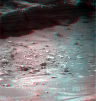
I know others will do a lot better - by getting rid of those horrible dark lines, for example - but I wanted to have a go... can't resist this low angle lighting... And a quick 3D of the base of the cliff... looks like there is some interesting terrain over there, some dips and hollows, and some very interesting rocks to look at close-up...
-------------------- |
||
|
|
|
||
|
Apr 6 2008, 05:27 PM
Post
#51
|
|
|
Senior Member Group: Moderator Posts: 2262 Joined: 9-February 04 From: Melbourne - Oz Member No.: 16 |
It looks like the 3rd row of the 1487 pan, that is not down yet, is of the sky. So this is a quick go at essentially the finished 6x2 image.
 Click image James -------------------- |
|
|
|
|
Apr 6 2008, 06:04 PM
Post
#52
|
|
|
Founder Group: Chairman Posts: 14433 Joined: 8-February 04 Member No.: 1 |
QUOTE (jamescanvin @ Apr 6 2008, 06:27 PM) It looks like the 3rd row of the 1487 pan, that is not down yet, is of the sky. Ryan ( http://martianchronicles.wordpress.com/ ) said that they downlinked all the thumbnails - but then threw away the sky images They commanded a bigger mosaic than they needed, as it was commanded in the blind before the drive.Doug |
|
|
|
|
Apr 8 2008, 04:21 AM
Post
#53
|
|
|
Newbie Group: Members Posts: 3 Joined: 12-March 08 Member No.: 4062 |
Yep, didn't want to waste bits downlinking blank sky images. I've posted the full-res false-color (uncalibrated) mosaic in my latest update: http://martianchronicles.wordpress.com/200...sols-1492-1494/ Enjoy! |
|
|
|
|
Apr 8 2008, 12:42 PM
Post
#54
|
||||
|
Senior Member Group: Moderator Posts: 4279 Joined: 19-April 05 From: .br at .es Member No.: 253 |
There are some fresh pictures on the Exploratorium of the latest move by Opportunity during sol 1495.
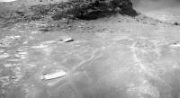
The latest significant drive was on sol 1491 (check the route map) and there were two "drive attempts" after that one, on sols 1493 and 1495, both of them resulting on tiny uphill movements. Have a look to the fhazcam shots from those sols here below (gamma corrected). Don't you think the forward left wheel is sliping and digging in the soil?  Sol 1491 (original: http://nasa.exploratorium.edu/mars/opportu...84P1212R0M1.JPG
Sol 1493 (original: http://nasa.exploratorium.edu/mars/opportu...86P1212R0M1.JPG
Sol 1495 (original: http://nasa.exploratorium.edu/mars/opportu...88P1212R0M1.JPG)
|
|||
|
|
|
|||
|
Apr 8 2008, 02:52 PM
Post
#55
|
|
|
Senior Member Group: Members Posts: 4252 Joined: 17-January 05 Member No.: 152 |
QUOTE (Tesheiner @ Apr 8 2008, 12:42 PM) Don't you think the forward left wheel is sliping and digging in the soil? I'd say it is digging in, to a small depth. But of course on such a steep slope even a small amount of slippage is concerning. When you look at these images it's easy to forget about the slope and mentally "subtract it off".On the other hand, we apparently have bedrock not far below the surface here. And the best rover drivers in the solar system at the wheel. I have to say though that I'm surprized that it appears they intend to take a direct route to the target, over this sandy surface, rather than following the exposed rock to the left (upslope) as far as possible, before heading downslope. Perhaps they've chosen the route with the shallowest slopes. |
|
|
|
|
Apr 9 2008, 01:16 AM
Post
#56
|
||
|
Senior Member Group: Admin Posts: 3108 Joined: 21-December 05 From: Canberra, Australia Member No.: 615 |
Animation of Tesheiner's and fredk's observation.
This is going to be a long and winding road. Astro0 |
|
|
|
|
|
|
Apr 9 2008, 01:49 PM
Post
#57
|
||
|
Senior Member Group: Moderator Posts: 4279 Joined: 19-April 05 From: .br at .es Member No.: 253 |
> This is going to be a long and winding road.
Definitely. Check the latest fhazcam shot from a few hours ago during sol 1496.
The original image without any "enhancements" is here: http://nasa.exploratorium.edu/mars/opportu...90P1213R0M1.JPG |
|
|
|
|
|
|
Apr 10 2008, 03:34 AM
Post
#58
|
|
|
Member Group: Members Posts: 350 Joined: 20-June 04 From: Portland, Oregon, U.S.A. Member No.: 86 |
Fear not, they will reach their goal. They must.
|
|
|
|
|
Apr 10 2008, 07:56 AM
Post
#59
|
|
|
Senior Member Group: Moderator Posts: 4279 Joined: 19-April 05 From: .br at .es Member No.: 253 |
I'm not sure to be correctly interpreting the mobility data from the PCTD but based on that info I calculated the amount of slippage which happened during the driving attempts of last sols. During sol 1493, Opportunity was expected to move some 24cm but actually moved just 7cm; that corresponds to 70% slippage. During sol 1495, she was expected to move 56cm but did only 5cm; 90% slippage. There are not enough data from sol 1496 to calculate any slippage factor.
Opportunity was scheduled to move again tosol (1497). Fingers crossed. |
|
|
|
|
Apr 10 2008, 09:34 PM
Post
#60
|
||
|
Founder Group: Chairman Posts: 14433 Joined: 8-February 04 Member No.: 1 |
View from Jan 11th of Oppy in Vic crater.
Attached thumbnail(s)
|
|
|
|
|
|
|
Apr 10 2008, 09:59 PM
Post
#61
|
||
|
Senior Member Group: Members Posts: 2922 Joined: 14-February 06 From: Very close to the Pyrénées Mountains (France) Member No.: 682 |
Nice to see her again from the sky. Is this the first pictures from Oppy inside Vicky ?
Something different. I cannot remember whether somebody already pointed out this possibility : Would be nice to send Oppy there on the way to Cape Verde : Edit : you'd better click on the image to see what I want to show :
-------------------- |
|
|
|
|
|
|
Apr 10 2008, 10:05 PM
Post
#62
|
|
|
The Poet Dude Group: Moderator Posts: 5551 Joined: 15-March 04 From: Kendal, Cumbria, UK Member No.: 60 |
That's really quite moving, seeing Oppy again from above. Brings home just how small she is, but how fearless too...!
-------------------- |
|
|
|
|
Apr 10 2008, 10:10 PM
Post
#63
|
|
|
Member Group: Members Posts: 279 Joined: 19-August 07 Member No.: 3299 |
If there is much sleepage, Oppy must move back until the platform and go to closer to Cape Verde and then go down. Not yet I have studied about the degree of transversability of the surface closer to the Cape verde.
|
|
|
|
|
Apr 11 2008, 07:39 AM
Post
#64
|
|
|
Senior Member Group: Moderator Posts: 4279 Joined: 19-April 05 From: .br at .es Member No.: 253 |
> If there is much sleepage, Oppy must move back until the platform ...
AFAIK that's what they are trying to do, without too much success. |
|
|
|
|
Apr 11 2008, 01:24 PM
Post
#65
|
|
 Senior Member Group: Members Posts: 1619 Joined: 12-February 06 From: Bergerac - FR Member No.: 678 |
Hi,
Still a long time without make pictures. So, after the beautiful pan of James, I want to show mine  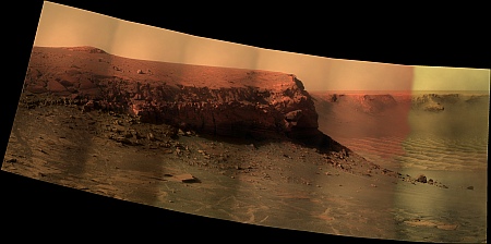 And a little desktop from it, with a new 16:9 format :  Bye, Damien. -------------------- |
|
|
|
|
Apr 12 2008, 08:37 AM
Post
#66
|
|
 Member Group: Members Posts: 144 Joined: 17-July 07 From: Canberra Australia Member No.: 2865 |
Hey Ant, Love your desktops and have had Cape St Mary as my backdrop for a long time. But why such a low resolution for your latest effort?
|
|
|
|
|
Apr 12 2008, 09:23 AM
Post
#67
|
|
|
Member Group: Members Posts: 350 Joined: 20-June 04 From: Portland, Oregon, U.S.A. Member No.: 86 |
Thanks for the desktop image.
|
|
|
|
|
Apr 12 2008, 02:54 PM
Post
#68
|
|
|
Member Group: Members Posts: 530 Joined: 21-March 06 From: Canada Member No.: 721 |
New pics up on exploratorium. Much close scrutiny of the surface by the pancam. Guess I'll await the panel's analysis now.
Brian |
|
|
|
|
Apr 12 2008, 04:43 PM
Post
#69
|
|
|
Senior Member Group: Members Posts: 1619 Joined: 12-February 06 From: Bergerac - FR Member No.: 678 |
QUOTE (Aussie @ Apr 12 2008, 10:37 AM) Hey Ant, Love your desktops and have had Cape St Mary as my backdrop for a long time. But why such a low resolution for your latest effort? Because I was thinking that a lot of people have more 16/9 size screen than traditionnal 4/3. But, If you want, I can make a version with previous resolution I used .Edit : for those like Aussi who prefer 1280 x 1024 px, here is a version of it : http://www.astrosurf.com/merimages/Desktop...esktop-1280.png -------------------- |
|
|
|
| Guest_Sunspot_* |
Apr 12 2008, 07:07 PM
Post
#70
|
|
Guests |
It looks like they may be stuck

|
|
|
|
|
Apr 13 2008, 03:19 AM
Post
#71
|
|
|
Member Group: Members Posts: 144 Joined: 17-July 07 From: Canberra Australia Member No.: 2865 |
Hi Ant,
The 16/9 sizing was great. It was just that a 6kb JPEG doesn't provide much definition compared to (for example) the 1.7 Meg PNG in your latest 4/3. |
|
|
|
|
Apr 13 2008, 10:06 AM
Post
#72
|
|
|
Senior Member Group: Moderator Posts: 4279 Joined: 19-April 05 From: .br at .es Member No.: 253 |
Another attempt to free the rover from the trap (I'm wondering on a name for it...) was executed on sol 1499.
The wheels were commanded to drive for about one meter but Opportunity had a net move of less then 10cm, making for more than 90% slippage. |
|
|
|
|
Apr 13 2008, 04:47 PM
Post
#73
|
|
|
Senior Member Group: Members Posts: 4252 Joined: 17-January 05 Member No.: 152 |
QUOTE (Tesheiner @ Apr 13 2008, 10:06 AM) I'm wondering on a name for it... Prepare yourselves: the Quackmire of Duck Bay!(He ducks, expecting to have ruffled many feathers...) [For non-native Englishers out there, quackmire = quagmire + quack (the sound an English duck makes!)] Seriously, though, at least some of the other wheels seem to be on pretty firm ground (right rear especially). And it won't take too many 10cm drives to get completely back on firm ground. But this certainly raises questions about getting to the base of the cliff... |
|
|
|
|
Apr 13 2008, 10:41 PM
Post
#74
|
||
|
The Poet Dude Group: Moderator Posts: 5551 Joined: 15-March 04 From: Kendal, Cumbria, UK Member No.: 60 |
Nice detail visible, even from this far away...
-------------------- |
|
|
|
|
|
|
Apr 14 2008, 03:13 AM
Post
#75
|
|
|
Member Group: Members Posts: 144 Joined: 17-July 07 From: Canberra Australia Member No.: 2865 |
QUOTE (fredk @ Apr 13 2008, 04:47 PM) But this certainly raises questions about getting to the base of the cliff... Quackmire. I think that will stick. But the question is raises is not about access th the cliff, but rather why they chose to drive back across the excavated holes instead of around them. Or did they intend to go back to do an MI on the scuff and overshot through miscalculation of the slippage going downhill compared to the initial uphill withdrawal drive? |
|
|
|
|
Apr 14 2008, 08:31 AM
Post
#76
|
|
|
Senior Member Group: Moderator Posts: 4279 Joined: 19-April 05 From: .br at .es Member No.: 253 |
QUOTE (fredk @ Apr 13 2008, 06:47 PM) Seriously, though, at least some of the other wheels seem to be on pretty firm ground (right rear especially). Are you sure? Unless my eyes are playing me a trick it looks like the right-rear wheel (left on the images) is not even touching the ground but is floating. |
|
|
|
|
Apr 14 2008, 11:49 AM
Post
#77
|
|
|
Member Group: Members Posts: 530 Joined: 21-March 06 From: Canada Member No.: 721 |
What sort of physical situation can cause a rear wheel to come off the ground in this system, and is such a situation possible where it is?
Brian |
|
|
|
|
Apr 14 2008, 11:57 AM
Post
#78
|
|
|
Founder Group: Chairman Posts: 14433 Joined: 8-February 04 Member No.: 1 |
The middle wheel digging in will do that quite easily.
Doug |
|
|
|
|
Apr 14 2008, 12:07 PM
Post
#79
|
|
|
Senior Member Group: Moderator Posts: 2262 Joined: 9-February 04 From: Melbourne - Oz Member No.: 16 |
If you compare the latest rhaz with some from a few sols ago you can see that the right rear has 'moved up' significantly. So it does look like the middle right has started to dig in.
Conversely though, it looks like the opposite is happening on the left side which may be a good sign (slightly nervous )James -------------------- |
|
|
|
|
Apr 14 2008, 03:12 PM
Post
#80
|
||
|
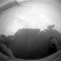
Senior Member Group: Members Posts: 4252 Joined: 17-January 05 Member No.: 152 |
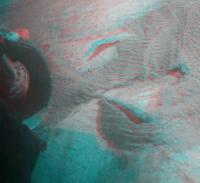
QUOTE (Tesheiner @ Apr 14 2008, 08:31 AM) ...it looks like the right-rear wheel (left on the images) is not even touching the ground but is floating. Yikes. It looks like you're right.  You can see that fairly clearly from an anaglyph:
|
|
|
|
|
|
|
Apr 14 2008, 03:36 PM
Post
#81
|
|
|
Senior Member Group: Members Posts: 1619 Joined: 12-February 06 From: Bergerac - FR Member No.: 678 |
Good catch Fredk. I had the impression by looking at the pictures and I didn't have the idea of the analgyph. And it's clear that the rear-left wheel is above the ground. I'm wondering if it's not the middle-left wheel who is deeply inserted into the ground, and she cause an elevation on rear wheel.
-------------------- |
|
|
|
|
Apr 14 2008, 06:42 PM
Post
#82
|
|
|
Member Group: Members Posts: 913 Joined: 4-September 06 From: Boston Member No.: 1102 |
The rocker bogie system is great for getting over uneven surfaces as long as they are solid. Unfortunately, there is no way to lock it (or move it) to a 6 flat wheel position for digging out of traps (sort of like 4 wheel drive on a car with differential locked to prevent slipping).
Opportunity's problem, and Spirit getting stuck in the bowl on top of home plate, may cause some re-thinking about rocker bogie designs for future rovers. -Floyd -------------------- |
|
|
|
|
Apr 14 2008, 07:41 PM
Post
#83
|
||
|
The Poet Dude Group: Moderator Posts: 5551 Joined: 15-March 04 From: Kendal, Cumbria, UK Member No.: 60 |
Next section of the latest pan...
-------------------- |
|
|
|
|
|
|
Apr 15 2008, 03:27 AM
Post
#84
|
|
|
Senior Member Group: Members Posts: 4252 Joined: 17-January 05 Member No.: 152 |
From The Martian Chronicals:
QUOTE Opportunity has been carefully extracting herself from a difficult little sand trap on the slope of Duck Bay in Victoria crater, but should be free and driving again sometime this week. Also there are nice new versions of the Cape Verde pan on that site.
|
|
|
|
|
Apr 15 2008, 03:13 PM
Post
#85
|
|
|
Senior Member Group: Members Posts: 4252 Joined: 17-January 05 Member No.: 152 |
|
|
|
|
|
Apr 15 2008, 03:19 PM
Post
#86
|
|
|
Founder Group: Chairman Posts: 14433 Joined: 8-February 04 Member No.: 1 |
****
I'll get the low res MER model out when I get home and see what you have to do to the rocker bogie to make that happen. It's more motion than the height of the whole wheel imho. Doug |
|
|
|
|
Apr 15 2008, 03:22 PM
Post
#87
|
|
 Member Group: Members Posts: 578 Joined: 5-November 04 From: Denmark Member No.: 107 |
-------------------- "I want to make as many people as possible feel like they are part of this adventure. We are going to give everybody a sense of what exploring the surface of another world is really like"
- Steven Squyres |
|
|
|
|
Apr 15 2008, 03:52 PM
Post
#88
|
|
|
Special Cookie Group: Members Posts: 2168 Joined: 6-April 05 From: Sintra | Portugal Member No.: 228 |
Looks R-E-A-L-L-Y high to me Doug...
Didn't the ground collapsed on Oppy's front left?... -------------------- "Ride, boldly ride," The shade replied, "If you seek for Eldorado!"
Edgar Alan Poe |
|
|
|
|
Apr 15 2008, 04:18 PM
Post
#89
|
|
|
Founder Group: Chairman Posts: 14433 Joined: 8-February 04 Member No.: 1 |
Not front left. Middle right.
Doug |
|
|
|
|
Apr 15 2008, 05:37 PM
Post
#90
|
|
|
Merciless Robot Group: Admin Posts: 8784 Joined: 8-December 05 From: Los Angeles Member No.: 602 |
Good grief!!!
That ain't right at all!!!
-------------------- A few will take this knowledge and use this power of a dream realized as a force for change, an impetus for further discovery to make less ancient dreams real.
|
|
|
|
| Guest_Sunspot_* |
Apr 15 2008, 06:01 PM
Post
#91
|
|
Guests |
Good Grief...
The middle wheel must be completely covered I should think. |
|
|
|
|
Apr 15 2008, 06:09 PM
Post
#92
|
|
 Senior Member Group: Members Posts: 3648 Joined: 1-October 05 From: Croatia Member No.: 523 |
What the heck?!?!
-------------------- |
|
|
|
|
Apr 15 2008, 07:08 PM
Post
#93
|
|
|
Senior Member Group: Moderator Posts: 4279 Joined: 19-April 05 From: .br at .es Member No.: 253 |
Aside of the "floating" wheel, the rover is clearly tilted to the right!
Just compare the latest rhazcam picture with a similar one from sol 1496. |
|
|
|
|
Apr 15 2008, 07:21 PM
Post
#94
|
|
|
Member Group: Members Posts: 913 Joined: 4-September 06 From: Boston Member No.: 1102 |
But the good news, looking at those two images, is that we have moved several cm up hill as indicated by the relative position of the triangular rock!
Floyd -------------------- |
|
|
|
|
Apr 15 2008, 08:04 PM
Post
#95
|
|
|
Senior Member Group: Moderator Posts: 4279 Joined: 19-April 05 From: .br at .es Member No.: 253 |
Here're some mobility data associated to today's drive. It was executed in six consecutive steps and each of them was expected to move the rover back some 55cm for a total of 3.3meters. Opportunity moved only 22cm with an average slip factor of 93%.
Fingers crossed! |
|
|
|
|
Apr 15 2008, 08:31 PM
Post
#96
|
|||
|
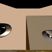
Founder Group: Chairman Posts: 14433 Joined: 8-February 04 Member No.: 1 |
Actually - it's not as bad as I thought.
My understanding is that the rocker ( the front wheel, thru the diff, to the bogie pivot ) can rotate + / - 20 degrees. The bogie ( the rear two wheels ) can rotate + / -30 degrees. And yes - if they both go max in the same direction, the rear wheel will contact the bottom of a solar array. BUT - on the upside - I don't think pulling a wheely like we are is as bad as all that after all. Probably about half-buried wheel. Attached - a low fidelity sim of the RHAZ having a look, the side view of the max bogie tilt, and a movie that shows, I think, the full suspension extent. Doug
Attached thumbnail(s)
Attached File(s)
|
||
|
|
|
||
|
Apr 15 2008, 09:16 PM
Post
#97
|
|
|
Member Group: Members Posts: 753 Joined: 23-October 04 From: Greensboro, NC USA Member No.: 103 |
Excellent illustration and movie, Doug!
Just goes to show what happens when you let things go around on 6 legs, instead of the 3 legs that the God of the Martians intended! H.G. Wells was right, again! -------------------- Jonathan Ward
Manning the LCC at http://www.apollolaunchcontrol.com |
|
|
|
|
Apr 15 2008, 09:45 PM
Post
#98
|
|
|
Merciless Robot Group: Admin Posts: 8784 Joined: 8-December 05 From: Los Angeles Member No.: 602 |
Well done, Doug, and thank you!
Man, that slip rate from the latest traverse, though...93%? Horrific. I suppose the blueberries are contributing significantly to this. Gee, why didn't the MER designers foresee them? All humor aside, though, I think that it might well be time to ask some serious questions, as I'm sure the MER team is busily doing. If Oppy goes down there, she really might not be able to get out. The cliff is an extremely tempting and of course scientifically significant target; is this the time to roll the dice? Hate to say it in a way, but I think the answer is yes. It would be much better to be stranded down there (God forbid) then out on the Meridiani plains with nothing, really, nearby to study. We would've killed to put one of the Vikings right where Oppy's trying to go, after all. -------------------- A few will take this knowledge and use this power of a dream realized as a force for change, an impetus for further discovery to make less ancient dreams real.
|
|
|
|
|
Apr 15 2008, 10:17 PM
Post
#99
|
|
|
The Poet Dude Group: Moderator Posts: 5551 Joined: 15-March 04 From: Kendal, Cumbria, UK Member No.: 60 |
Having heard Steve S talking on this week's Planetary Radio show, I think it's v v unlikely there'll be any rolling of any dice. He was adamant that VC will NOT be Oppy's final resting place, that she has a lot more work to do outside, back up on the plains. For those who didn't hear the show yet - I say "yet" because everyone should go over to Emily's blog and download the show asap - SS said that they are looking at two possible "campaigns" for Oppy, post-VC. #1: "The Cobble Campaign", where Oppy would re-trace some of her tracks and go back and examine some of the interesting cobbles, stones and meteorites she scooted past in her haste to reach VC. SS said that the "Cobbles" are a very diverse mix, in great contrast to the bedrock seen by Oppy. Some are meteorites, some are ejecta from craters a long way away, and so represent samples of material deeper beneath the surface of Meridiani than seen elsewhere and so far by Oppy. He would like Oppy to go back and take a good close look at these to learn more about the sub-surface of Mars. Campaign #2 would be to go and find some more outcrops of rock and features where water came to the surface.
So, I think that if it comes down to a choice between a glorious game of Rover Roulette and a tactical if grudging withdrawl from VC, I think they'll go with the latter. -------------------- |
|
|
|
|
Apr 16 2008, 12:55 AM
Post
#100
|
|
|
Senior Member Group: Members Posts: 4252 Joined: 17-January 05 Member No.: 152 |
I agree there's work to do out on the plains. Does anyone have a clear idea of exactly what we might learn from an approach to Verde cliff? I mean, we have studied the layers pretty well on our traverse into Victoria so far. But judging from the imagery, the layers they talked about tasting on the cliff are quite a bit lower down than we've sampled so far? Is that all that matters here - getting lower into the layering? Or might they learn something worthwhile by looking closely at the same layers we've already tasted, but now crossing the cliff face?
|
|
|
|
 |

|
Lo-Fi Version | Time is now: 7th June 2024 - 11:46 AM |
|
RULES AND GUIDELINES Please read the Forum Rules and Guidelines before posting. IMAGE COPYRIGHT |
OPINIONS AND MODERATION Opinions expressed on UnmannedSpaceflight.com are those of the individual posters and do not necessarily reflect the opinions of UnmannedSpaceflight.com or The Planetary Society. The all-volunteer UnmannedSpaceflight.com moderation team is wholly independent of The Planetary Society. The Planetary Society has no influence over decisions made by the UnmannedSpaceflight.com moderators. |
SUPPORT THE FORUM Unmannedspaceflight.com is funded by the Planetary Society. Please consider supporting our work and many other projects by donating to the Society or becoming a member. |
|