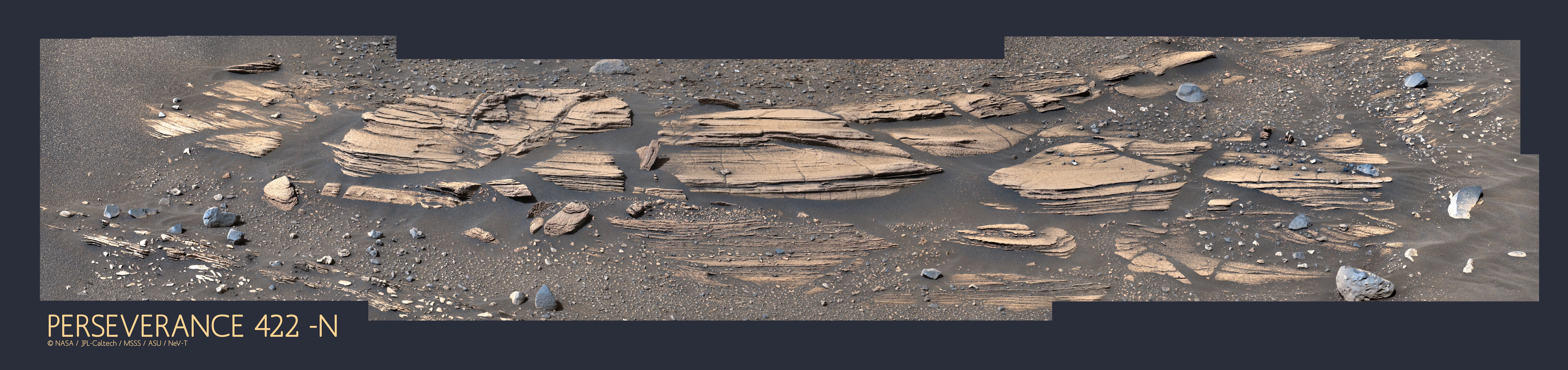
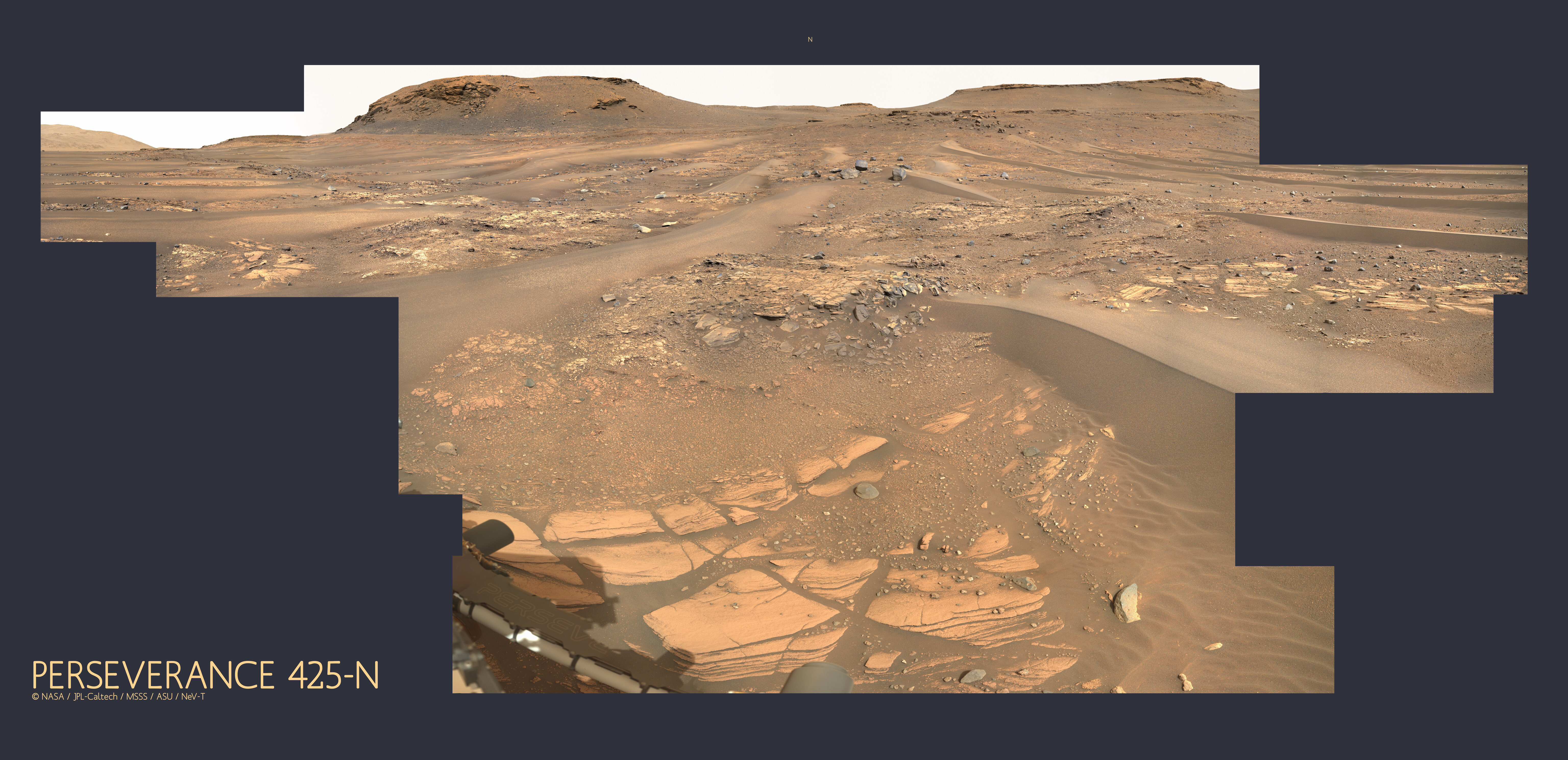
Jezero Delta Campaign, Sols 414-1000, 21 Apr 2022- 23 Dec 2023 |

Jezero Delta Campaign, Sols 414-1000, 21 Apr 2022- 23 Dec 2023 |
 Apr 21 2022, 07:21 PM Apr 21 2022, 07:21 PM
Post
#1
|
|
|
Member  Group: Members Posts: 362 Joined: 13-April 06 From: Malta Member No.: 741 |
Think we can kick off the new phase of exploration at Jezero.
|
 |
 
|
 |
|
Apr 22 2022, 02:28 AM
Post
#2
|
||
|
Solar System Cartographer Group: Members Posts: 10166 Joined: 5-April 05 From: Canada Member No.: 227 |
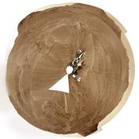
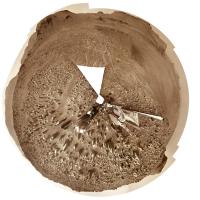
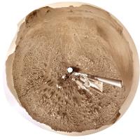
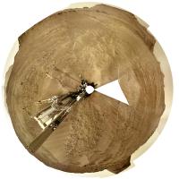
Yes, I was thinking that. The new delta campaign has begun according to the press release.
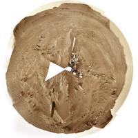
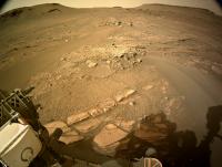
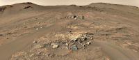
This is the sol 415 circular panorama showing us between the big drifts or ripples (aeolian bedforms), reminiscent of Opportunity many years ago. I haven't done the sol 414 version because I don't really want to deal with the multi-tile Navcams (4 tiles is bad enough, 16 is way too much for me to tackle with other work piling up). If someone makes a panorama for sol 414 I will use that to make a circular view. Phil
-------------------- ... because the Solar System ain't gonna map itself.
Also to be found posting similar content on https://mastodon.social/@PhilStooke Maps for download (free PD: https://upload.wikimedia.org/wikipedia/comm...Cartography.pdf NOTE: everything created by me which I post on UMSF is considered to be in the public domain (NOT CC, public domain) |
|
|
|
|
|
|
Apr 22 2022, 08:20 AM
Post
#3
|
|
|
Merciless Robot Group: Admin Posts: 8784 Joined: 8-December 05 From: Los Angeles Member No.: 602 |
Topic title edited to include sol range- admin

-------------------- A few will take this knowledge and use this power of a dream realized as a force for change, an impetus for further discovery to make less ancient dreams real.
|
|
|
|
|
Apr 22 2022, 01:04 PM
Post
#4
|
|
 Senior Member Group: Members Posts: 2429 Joined: 30-January 13 From: Penang, Malaysia. Member No.: 6853 |
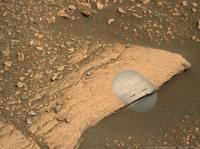
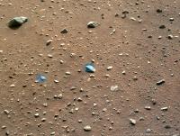
There's a NavCam thumbnail image of the sun from sol 416 with metadata that suggests there was a drive to site 23-1180 from site 23-0824. Looks like the images are late or they'll acquire them the following morning

|
|
|
|
|
Apr 22 2022, 05:01 PM
Post
#5
|
||||
 Member Group: Members Posts: 670 Joined: 9-May 21 From: Germany Member No.: 9017 |
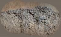
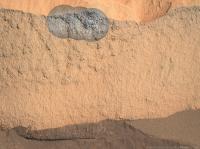
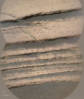
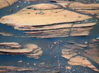
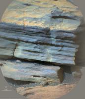
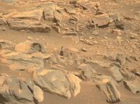
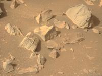
Sol 416 Supercam Remote Micro-Imager with Mastcam-Z and Navcam context
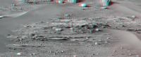
Finely laminated horizontal layering at the base of the hillside - are these the lake sediments we are looking for?
|
|||
|
|
|
|||
|
Apr 22 2022, 06:35 PM
Post
#6
|
|||
|
Solar System Cartographer Group: Members Posts: 10166 Joined: 5-April 05 From: Canada Member No.: 227 |
Very nice images, Tau. I hope we can get to those outcrops.
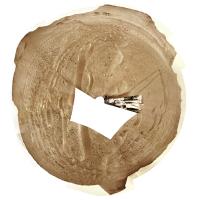
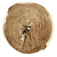
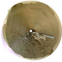
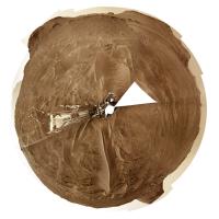
I changed my mind and made a sol 414 circular pan, using just the upper tier of the multi-tile Navcams to save time. Because of the projection I use the coverage even in just the upper tier is quite extensive. These circular images don't need a special viewer. They are like a standard polar projection except that the radial scale is changed (roughly equivalent to a stereographic projection). The basic idea is that the middle part is like a map:
and the full image includes the horizon features all displayed at the correct azimuth. North is always at the top (or very near it):
Phil -------------------- ... because the Solar System ain't gonna map itself.
Also to be found posting similar content on https://mastodon.social/@PhilStooke Maps for download (free PD: https://upload.wikimedia.org/wikipedia/comm...Cartography.pdf NOTE: everything created by me which I post on UMSF is considered to be in the public domain (NOT CC, public domain) |
||
|
|
|
||
|
Apr 22 2022, 08:32 PM
Post
#7
|
|
 Member Group: Members Posts: 810 Joined: 3-June 04 From: Brittany, France Member No.: 79 |
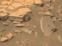
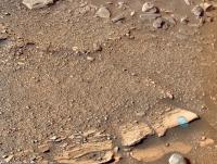
End of sol 416 afternoon on Kodiak hill, taken with Navcam Left.

-------------------- |
|
|
|
|
Apr 23 2022, 03:13 AM
Post
#8
|
||
|
Solar System Cartographer Group: Members Posts: 10166 Joined: 5-April 05 From: Canada Member No.: 227 |
Sol 416, lots of rocks here but the biggest drifts are behind us.
Phil
-------------------- ... because the Solar System ain't gonna map itself.
Also to be found posting similar content on https://mastodon.social/@PhilStooke Maps for download (free PD: https://upload.wikimedia.org/wikipedia/comm...Cartography.pdf NOTE: everything created by me which I post on UMSF is considered to be in the public domain (NOT CC, public domain) |
|
|
|
|
|
|
Apr 23 2022, 08:39 AM
Post
#9
|
||
|
Junior Member Group: Members Posts: 75 Joined: 8-July 15 Member No.: 7566 |
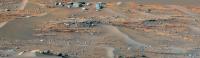
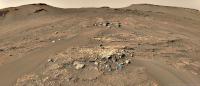
Remember that huge Mastcam-Z panorama from Sol 406? and at the left in the far distance there was an erosional surface preserved in the strata, but the image quality was quite poor? Well we now have our first high resolution view of that outcrop, taken on Sol 415. It shows the same tripartite system we've seen on Kodiak and elsewhere: inclined strata sandwiched between two horizontally bedded units.
|
|
|
|
|
|
|
Apr 23 2022, 10:21 AM
Post
#10
|
|
 Member Group: Members Posts: 648 Joined: 9-May 05 From: Subotica Member No.: 384 |
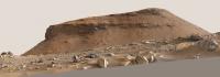
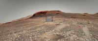
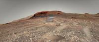
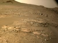
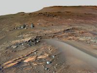
Kodiak Hill imaged by Mars Perseverances Mastcam-Z.camera on sol 416.
Just about 450 meters away from Kodiak hill. I think this is as close as we are going to see this feature ever.  Panorama Sol 416 M2020.jpg1 by Tomislav Bandin, on Flickr Panorama Sol 416 M2020.jpg1 by Tomislav Bandin, on Flickr
-------------------- The scientist does not study nature because it is useful; he studies it because he delights in it, and he delights in it because it is beautiful.
Jules H. Poincare My "Astrophotos" gallery on flickr... |
|
|
|
|
Apr 23 2022, 12:04 PM
Post
#11
|
||
|
Member Group: Members Posts: 670 Joined: 9-May 21 From: Germany Member No.: 9017 |
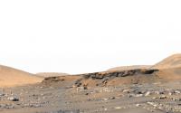
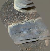
Yet another mosaic of Kodiak on sol 416, rotated to the horizontal
Interesting the multiple and partially opposed discordances in the upper center of the image
|
|
|
|
|
|
|
Apr 23 2022, 03:14 PM
Post
#12
|
|
|
Senior Member Group: Members Posts: 1044 Joined: 17-February 09 Member No.: 4605 |
Nice image Tau. There appears to be a transition in depositional environment from left to right with the distance between topsets and bottomsets narrowing with an apparent transition to a more energetic, turbulent flow. Unfortunately much of the transition point is obscured by detritus.
|
|
|
|
|
Apr 23 2022, 04:35 PM
Post
#13
|
|
|
Member Group: Members Posts: 233 Joined: 14-January 22 Member No.: 9140 |
Perhaps this was noted in earlier threads, but when we see a feature like this stand so tall above the surrounding plains, but cover such a small part of the area, that means that locally the erosion of other delta material must have been absolutely massive, right? And likely the only agent capable of carrying so much material away would have been catastrophic flooding, right? So while we see, in the hill and more generally in the delta layers built up by one era of water flow, there must have been subsequent eras (or episodes) of water flow that tore a lot of that down in the direction from the remaining delta material towards the center of the crater. Does that sound right or am I missing some other possible agent of erosion? Wind, impacts, and seismic activity from Syrtis Major seem like other possible agents in the destruction of the delta's original edge, but for so much material to be carried away, it seems like water had to be a major player.
|
|
|
|
|
Apr 23 2022, 05:36 PM
Post
#14
|
|
 Member Group: Members Posts: 714 Joined: 3-January 08 Member No.: 3995 |
It's possible the thick cross-bedded unit in Kodiak butte was formed by eolian processes. Sand dunes and drifts likely formed across the delta during dry periods. The cross-beds seem to dip to the southwest (or somewhere between south and east), which would be unexpected with those formed by fluvial processes on the delta. Perhaps coastal dunes formed as the lake level dropped and sediment became available to wind transport.
As for Kodiak butte itself, it could be an old crater pedestal, where the rock altered by the impact became slightly more resistant than the surrounding material. Over time, the rest is eroded away by mass wasting and wind, leaving the neat little butte. |
|
|
|
|
Apr 23 2022, 06:55 PM
Post
#15
|
|
|
Founder Group: Chairman Posts: 14432 Joined: 8-February 04 Member No.: 1 |
QUOTE (StargazeInWonder @ Apr 23 2022, 09:35 AM)  And likely the only agent capable of carrying so much material away would have been catastrophic flooding, right? Nope. Hundreds of millions of years and wind erosion are capable of this. See the best understood evolution of Gale Crater for similar massive volumes of wind erosion. An incredibly slow mode of erosion, over incredibly long periods of time can literally vanish mountains. |
|
|
|
|
Apr 24 2022, 03:16 AM
Post
#16
|
|
|
Senior Member Group: Members Posts: 1044 Joined: 17-February 09 Member No.: 4605 |
QUOTE (StargazeInWonder @ Apr 23 2022, 04:35 PM) ...but when we see a feature like this stand so tall above the surrounding plains, but cover such a small part of the area, that means that locally the erosion of other delta material must have been absolutely massive.... The maximum extent of the original deltas is not known but there are delta remnants similar to Kodiak some 3 km to the East of the current Neretva Vallis delta edge. Mars was probably a quite energetic environment when the lake dried out with reasonably rapid (in geological terms) erosion and step-back of the delta front. This occurred between the final drying out of the lake and the effusive lava that spread across the crater floor and embayed the delta and outlying remnants. As djellison indicates the environment now is most benign and any erosion is painfully slow. |
|
|
|
|
Apr 24 2022, 01:51 PM
Post
#17
|
|
 Senior Member Group: Members Posts: 1619 Joined: 12-February 06 From: Bergerac - FR Member No.: 678 |
Sol 415 MastcamZ mosaic of that wonderful mesa :
 And the same Sol, Navcam full panoramic : 
-------------------- |
|
|
|
|
Apr 25 2022, 06:10 AM
Post
#18
|
||
|
Solar System Cartographer Group: Members Posts: 10166 Joined: 5-April 05 From: Canada Member No.: 227 |
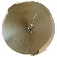
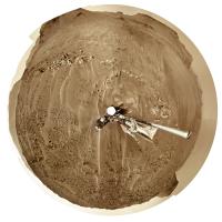
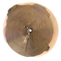
Very nice, Damia. I couldn't resist making a circular version, hope you don't mind. This is without any extra processing. Later i will look at a higher contrast version.
We just had another drive on sol 418. Phil
Attached thumbnail(s)
-------------------- ... because the Solar System ain't gonna map itself.
Also to be found posting similar content on https://mastodon.social/@PhilStooke Maps for download (free PD: https://upload.wikimedia.org/wikipedia/comm...Cartography.pdf NOTE: everything created by me which I post on UMSF is considered to be in the public domain (NOT CC, public domain) |
|
|
|
|
|
|
Apr 25 2022, 06:27 PM
Post
#19
|
||
|
Member Group: Members Posts: 714 Joined: 3-January 08 Member No.: 3995 |
They have begun to image the light-colored beds at the base of Cape Nukshak:
|
|
|
|
|
|
|
Apr 25 2022, 07:03 PM
Post
#20
|
||
|
Solar System Cartographer Group: Members Posts: 10166 Joined: 5-April 05 From: Canada Member No.: 227 |
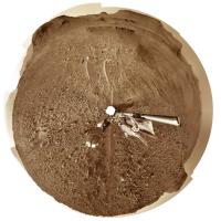
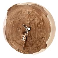
The sol 418 panorama in circular form. Another drive on sol 419! - but not very long.
Phil
-------------------- ... because the Solar System ain't gonna map itself.
Also to be found posting similar content on https://mastodon.social/@PhilStooke Maps for download (free PD: https://upload.wikimedia.org/wikipedia/comm...Cartography.pdf NOTE: everything created by me which I post on UMSF is considered to be in the public domain (NOT CC, public domain) |
|
|
|
|
|
|
Apr 25 2022, 09:08 PM
Post
#21
|
||
|
Solar System Cartographer Group: Members Posts: 10166 Joined: 5-April 05 From: Canada Member No.: 227 |
Sol 419. Not sure if we are turning to examine something interesting, or to improve helicopter communications for a new flight (or those parachute images).
Phil
-------------------- ... because the Solar System ain't gonna map itself.
Also to be found posting similar content on https://mastodon.social/@PhilStooke Maps for download (free PD: https://upload.wikimedia.org/wikipedia/comm...Cartography.pdf NOTE: everything created by me which I post on UMSF is considered to be in the public domain (NOT CC, public domain) |
|
|
|
|
|
|
Apr 25 2022, 09:44 PM
Post
#22
|
|
|
Senior Member Group: Members Posts: 2998 Joined: 30-October 04 Member No.: 105 |
I presume that we've driven up on that Nukshak plateau.
-------------------- |
|
|
|
|
Apr 25 2022, 10:03 PM
Post
#23
|
|
|
Member Group: Members Posts: 362 Joined: 13-April 06 From: Malta Member No.: 741 |
From the latest rover position it looks like Percy is still on the crater floor but probably plans to access the lower strata of the delta plateau from this location..easier access to avoid sand dunes perhaps?
|
|
|
|
|
Apr 26 2022, 02:24 AM
Post
#24
|
||
|
Senior Member Group: Members Posts: 2998 Joined: 30-October 04 Member No.: 105 |
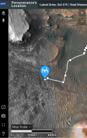
Sol 419 update of Rover's location (quick screengrab).
Attached thumbnail(s)
-------------------- |
|
|
|
|
|
|
Apr 26 2022, 09:40 AM
Post
#25
|
|
|
Senior Member Group: Members Posts: 1619 Joined: 12-February 06 From: Bergerac - FR Member No.: 678 |
Sol 419 Navcam panoramic. I just love here that feel of climbing up a hill.
-------------------- |
|
|
|
|
Apr 26 2022, 05:48 PM
Post
#26
|
||
|
Solar System Cartographer Group: Members Posts: 10166 Joined: 5-April 05 From: Canada Member No.: 227 |
That's a very nice panorama! Thanks, Damia.
This is sol 420's view in circular form. We moved about 60 m north to a rocky ledge. Phil
-------------------- ... because the Solar System ain't gonna map itself.
Also to be found posting similar content on https://mastodon.social/@PhilStooke Maps for download (free PD: https://upload.wikimedia.org/wikipedia/comm...Cartography.pdf NOTE: everything created by me which I post on UMSF is considered to be in the public domain (NOT CC, public domain) |
|
|
|
|
|
|
Apr 26 2022, 07:41 PM
Post
#27
|
||||
|
Member Group: Members Posts: 670 Joined: 9-May 21 From: Germany Member No.: 9017 |
1. Sol 419 Mastcam-Z left eye filters 1 to 6 multispectral principal components false colors
2. Navcam context 3. Mastcam-Z left eye filter 0 (RGB) raw image for comparison 1
|
|||
|
|
|
|||
|
Apr 26 2022, 08:16 PM
Post
#28
|
|
 Member Group: Members Posts: 868 Joined: 9-September 17 From: UK Member No.: 8241 |
-------------------- |
|
|
|
|
Apr 26 2022, 10:07 PM
Post
#29
|
|
 Member Group: Members Posts: 700 Joined: 3-December 04 From: Boulder, Colorado, USA Member No.: 117 |
Spectacular! And welcome to the forum.
John |
|
|
|
|
Apr 27 2022, 02:38 AM
Post
#30
|
|
|
Member Group: Members Posts: 868 Joined: 9-September 17 From: UK Member No.: 8241 |
-------------------- |
|
|
|
|
Apr 27 2022, 09:03 AM
Post
#31
|
|
|
Senior Member Group: Members Posts: 1619 Joined: 12-February 06 From: Bergerac - FR Member No.: 678 |
Thanks Phil
Sol 420 Navcam panoramic. I really love this place, it's nice to finally see changes in the landscape.  Also deserved a Postcard : 
-------------------- |
|
|
|
|
Apr 27 2022, 10:05 AM
Post
#32
|
||
|
Junior Member Group: Members Posts: 75 Joined: 8-July 15 Member No.: 7566 |
QUOTE (neville thompson @ Apr 26 2022, 09:16 PM) Gigapan - PERSEVERANCE 419 -N © NASA/JPL-Caltech/MSSS/ASU/NeV-T I think this portion of your panorama might be our best view of Neretva Vallis yet. Neretva Vallis is the canyon cutting through the crater wall of Jezero Crater about 7 km to the NW, through which the river that formed the Jezero delta flowed. Once the rover drives ontop of the delta, we'll finally get to see an unobstructed view of the canyon which we'll be driving through in a year or two.
|
|
|
|
|
|
|
Apr 27 2022, 10:31 AM
Post
#33
|
|||
|
Member Group: Members Posts: 670 Joined: 9-May 21 From: Germany Member No.: 9017 |
Sol 420 Supercam Remote Micro-Imager mosaic with sol 419 Navcam context
The mosaic shows the upper right corner of the sol 419 Mastcam-Z multispectral photo (see post #27), but from a slightly different perspective.
|
||
|
|
|
||
|
Apr 27 2022, 01:07 PM
Post
#34
|
|||
|
Member Group: Members Posts: 670 Joined: 9-May 21 From: Germany Member No.: 9017 |
Another sol 420 Supercam Remote Micro-Imager mosaic with sol 420 Mastcam-Z context
|
||
|
|
|
||
|
Apr 27 2022, 01:09 PM
Post
#35
|
|||
|
Newbie Group: Members Posts: 16 Joined: 27-February 22 Member No.: 9153 |
QUOTE (tau @ Apr 27 2022, 11:31 AM) Sol 420 Supercam Remote Micro-Imager mosaic with sol 419 Navcam context The mosaic shows the upper right corner of the sol 419 Mastcam-Z multispectral photo (see post #27), but from a slightly different perspective.
very nice view tau ! Distance: 310 m (rmi scale is 2.2 cm per pixel at 2000 m - source Dr. Gwénaël Caravaca) |
||
|
|
|
||
|
Apr 27 2022, 01:38 PM
Post
#36
|
|
|
Member Group: Members Posts: 700 Joined: 3-December 04 From: Boulder, Colorado, USA Member No.: 117 |
QUOTE (tau @ Apr 27 2022, 06:07 AM) Another sol 420 Supercam Remote Micro-Imager mosaic with sol 420 Mastcam-Z context First closeup of the bedrock hereabouts. The texture looks like the Séítah rocks at first glance. But we may not have transitioned to the sub-delta layered unit yet. John |
|
|
|
|
Apr 27 2022, 05:23 PM
Post
#37
|
||
|
Member Group: Members Posts: 700 Joined: 3-December 04 From: Boulder, Colorado, USA Member No.: 117 |
...aaand now we've transitioned to the layered unit:
|
|
|
|
|
|
|
Apr 27 2022, 06:51 PM
Post
#38
|
|
 Member Group: Members Posts: 684 Joined: 24-July 15 Member No.: 7619 |
QUOTE (neville thompson @ Apr 27 2022, 02:38 AM) Wow, amazing shot. Definitely should be "Jakku lithofacies" due to the resemblance to fictional planet covered in crashed star destroyers... |
|
|
|
|
Apr 28 2022, 03:34 AM
Post
#39
|
||
|
Solar System Cartographer Group: Members Posts: 10166 Joined: 5-April 05 From: Canada Member No.: 227 |
Sol 421, circular panorama with some nice outcrops between the aeolian ridges.
Phil
-------------------- ... because the Solar System ain't gonna map itself.
Also to be found posting similar content on https://mastodon.social/@PhilStooke Maps for download (free PD: https://upload.wikimedia.org/wikipedia/comm...Cartography.pdf NOTE: everything created by me which I post on UMSF is considered to be in the public domain (NOT CC, public domain) |
|
|
|
|
|
|
Apr 28 2022, 08:57 AM
Post
#40
|
||
|
Junior Member Group: Members Posts: 75 Joined: 8-July 15 Member No.: 7566 |
I concur with john_s. The rocks on Sol 420, best seen in Ant103's panorama, in my opinion look like the igneous rocks we saw earlier. Their colour, texture, and subdued relief reminds me of the upper Maaz formation members encountered early in the mission, remember the first failed coring attempt? Meanwhile the Sol 421 lithology is very different and is all consistent with prodelta mudstones, which must be an exciting moment for the mission's geologists.
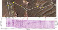
That means sometime in the last drive, the rover crossed the geological contact between the two units. On the surface, this contact may not have been spotted, as the area is covered in sand ripples and the contact is between two quite soft rock types. However, perhaps they've detected the contact in the subsurface using Rimfax, the radar instrument. In fact, the last two drives look very well suited for doing such a radar survey: the rover pivoted northwards and has conducted a nearly straight, N-S transect across the boundary, so I expect that's what they're doing right now. The rover did this same thing the last time it crossed a major boundary, when it entered the Seitah Formation around Sol 200 (see image for the results of that survey). I wonder if this was a major motivation for the rover planners choosing to come here in the first place instead of going to Hawksbill Gap: because this area better preserves the contact between the delta and the lava flow, allowing them to do a transect & Rimfax survey.
|
|
|
|
|
|
|
Apr 28 2022, 12:41 PM
Post
#41
|
|
|
Senior Member Group: Members Posts: 1044 Joined: 17-February 09 Member No.: 4605 |
Given the step back of the delta and what appears to be a contact between the effusive lava and sedimentary deposits I feel the layered unit is more likely later delta deposits than prodelta/lake bed remnants. Getting close up and personal will tell the tale.
|
|
|
|
|
Apr 28 2022, 12:56 PM
Post
#42
|
||||
|
Member Group: Members Posts: 670 Joined: 9-May 21 From: Germany Member No.: 9017 |
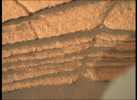
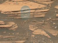
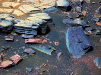
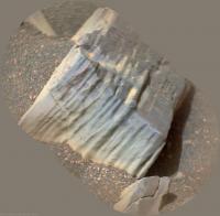
Layered outcrops at the base of Cape Nukshak.
1. Sol 420 Mastcam-Z image mosaic from a distance of about 44 m, with enhanced colors. I see two different layered units here: a bluish-gray unit on top of a orange-brown unit. 2. Sol 420 Mastcam-Z anaglyph 3. Sol 421 Navcam, now very close (about 5 m) 1
|
|||
|
|
|
|||
|
Apr 28 2022, 08:32 PM
Post
#43
|
||
|
Junior Member Group: Members Posts: 75 Joined: 8-July 15 Member No.: 7566 |
I agree, there's two distinct units here, corresponding to the different colours of the "bacon strip". I wonder what the significance of that colour difference is? This Mastcam zoom-in taken today shows cm or mm-scale layering. Perhaps that represents annual cyclicity. The grain size seems to be too fine to resolve individual grains, certainly it's finer-grained than the aeolian sediment ontop of it. I hope the rover does an abrasion here so we can see how thin the layering is & try and resolve some grains with the hand lens.
|
|
|
|
|
|
|
Apr 28 2022, 09:42 PM
Post
#44
|
||
|
Senior Member Group: Members Posts: 2429 Joined: 30-January 13 From: Penang, Malaysia. Member No.: 6853 |
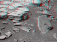
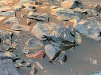
Sol 422 NavCam after a short bump
I have a feeling we could be here for a while
|
|
|
|
|
|
|
Apr 29 2022, 03:25 AM
Post
#45
|
||
|
Solar System Cartographer Group: Members Posts: 10166 Joined: 5-April 05 From: Canada Member No.: 227 |
Sol 422 circular view. As Paul says, just a small move.
Phil
-------------------- ... because the Solar System ain't gonna map itself.
Also to be found posting similar content on https://mastodon.social/@PhilStooke Maps for download (free PD: https://upload.wikimedia.org/wikipedia/comm...Cartography.pdf NOTE: everything created by me which I post on UMSF is considered to be in the public domain (NOT CC, public domain) |
|
|
|
|
|
|
Apr 29 2022, 01:36 PM
Post
#46
|
|
|
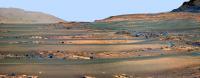
Member Group: Members Posts: 810 Joined: 3-June 04 From: Brittany, France Member No.: 79 |
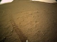
Peaceful sight of the rover's tracks winding across the floor of Jezero crater, imaged on sol 422 by Mastcam-Z Left.

-------------------- |
|
|
|
|
Apr 29 2022, 04:46 PM
Post
#47
|
||||
|
Member Group: Members Posts: 670 Joined: 9-May 21 From: Germany Member No.: 9017 |
Indeed, a very peaceful and beautiful picture. It looks like a romantic painting.
Layered outcrops at the base of Cape Nukshak, seen from a distance of about 6 m on sol 422 1. Supercam Remote Micro-Imager. A very rough grain-size estimate: in the rock about 0.4 to 0.5 mm, dark sand 0.2 to 0.3 mm 2. Mastcam-Z context 3. Mastcam-Z left eye filters 1 to 6 multispectral principal components
|
|||
|
|
|
|||
|
Apr 29 2022, 07:58 PM
Post
#48
|
|||||
|
Member Group: Members Posts: 670 Joined: 9-May 21 From: Germany Member No.: 9017 |
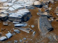
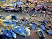
More layered outcrops at the base of Cape Nukshak in Mastcam-Z images from sol 423
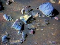
1. Raw image filter 0 (RGB) 2. Left eye filters 1 to 6 multispectral principal components. A few stones have alternating blue/purple layers. 3. Right eye infrared filters 1 to 6 multispectral principal components 1 and 2 4. Anaglyph
|
||||
|
|
|
||||
|
Apr 30 2022, 08:19 AM
Post
#49
|
|||||
|
Newbie Group: Members Posts: 16 Joined: 27-February 22 Member No.: 9153 |
QUOTE (tau @ Apr 29 2022, 08:58 PM) More layered outcrops at the base of Cape Nukshak in Mastcam-Z images from sol 423 1. Raw image filter 0 (RGB) 2. Left eye filters 1 to 6 multispectral principal components. A few stones have alternating blue/purple layers. 3. Right eye infrared filters 1 to 6 multispectral principal components 1 and 2 4. Anaglyph
Tau : any clue as to what minerals the colors represent? do we have mudstone here ? grain is not visible but the resolution lacks a bit it seems |
||||
|
|
|
||||
|
Apr 30 2022, 03:09 PM
Post
#50
|
|
|
Member Group: Members Posts: 868 Joined: 9-September 17 From: UK Member No.: 8241 |
-------------------- |
|
|
|
|
Apr 30 2022, 07:54 PM
Post
#51
|
|
|
Member Group: Members Posts: 868 Joined: 9-September 17 From: UK Member No.: 8241 |
-------------------- |
|
|
|
|
Apr 30 2022, 08:18 PM
Post
#52
|
|
|
Member Group: Members Posts: 810 Joined: 3-June 04 From: Brittany, France Member No.: 79 |
Panorama taken with Navcam Left (my first attempt to this tricky dataset!) on sol 422 at 14:12 LMST.

-------------------- |
|
|
|
|
Apr 30 2022, 08:40 PM
Post
#53
|
|
|
Member Group: Members Posts: 670 Joined: 9-May 21 From: Germany Member No.: 9017 |
QUOTE (Keltos @ Apr 30 2022, 10:19 AM) Tau : any clue as to what minerals the colors represent? Sorry, no clue. The colors are somewhat arbitrary, because the results of the principal components analysis depent on the overall image content and some manual adjustments. Irrespective of this, radiometrically calibrated multispectral image data are required for mineral determination. An idea of the calibration and processing pipeline is given by this paper, this paper, and this document. With radiometrically calibrated data and mineral spectra libraries, it might be possible, see the "Mineralogy" chapter and Fig. 3 in this paper. The rover has further instruments for elemental and mineral analysis (SuperCam, SHERLOC). |
|
|
|
|
Apr 30 2022, 09:11 PM
Post
#54
|
|
|
Member Group: Members Posts: 233 Joined: 14-January 22 Member No.: 9140 |
I think with PCA, all that you can safely say about two highly contrasting colors is that there is a difference between two things, but there's no definite information about the nature of that difference, and it could easily be some combination of illumination, texture, composition or possibly other things, in any unknown combination.
For example, when you see the color patterns where oil or gasoline and water are on wet pavement, the color differences have absolutely nothing to do with compositional differences. An image of snow and ice might show considerable variation in color even though every bit of solid present is pure H2O. Moreover, with the PCA, the contrasts seen across one part of the image are further altered by what happens to be present in other parts of the image. We may easily be looking at one more or less constant composition of the rocks in these photos with different history of weathering, burial, dust cover, etc. |
|
|
|
|
Apr 30 2022, 09:19 PM
Post
#55
|
|
|
Member Group: Members Posts: 868 Joined: 9-September 17 From: UK Member No.: 8241 |
-------------------- |
|
|
|
|
Apr 30 2022, 10:34 PM
Post
#56
|
|
|
Senior Member Group: Members Posts: 2998 Joined: 30-October 04 Member No.: 105 |
Very good, Tau. My sense suggests to me that the finely-bedded bluish rocks are silt- or mudstones. Fine particle sizes that remained in suspension and settled away from the early delta. The purplish rocks are a different mineralogy and are somtimes associated with the siltstone units, which may well.be cyclic. Some purplish rocks appear to be coarse grained and may represent rocks that have tumbled down from higher in the section, or may represent cataclysmic flows in the streams or may represent turbidites from the delta. The mineralogical difference may be the result of intense chemical weathering of volcanic rocks in wet basins of the upland that were breached during intense rainfall events and entered the streams as a slug.
--Bill -------------------- |
|
|
|
|
May 1 2022, 05:54 AM
Post
#57
|
|
|
Senior Member Group: Members Posts: 1044 Joined: 17-February 09 Member No.: 4605 |
If you are right that the deposition was fallout in the lake prior to delta formation Bill then couldn't the banded layers reflect variations in oxygenation conditions within the lake? Assuming an abiotic influence, say periodic changes in cloud or ash cover affecting levels of UV at the surface and potentially shallow water.
|
|
|
|
|
May 1 2022, 09:47 AM
Post
#58
|
|
|
Member Group: Members Posts: 670 Joined: 9-May 21 From: Germany Member No.: 9017 |
QUOTE (StargazeInWonder @ Apr 30 2022, 11:11 PM) I think with PCA, all that you can safely say about two highly contrasting colors is that there is a difference between two things, but there's no definite information about the nature of that difference, and it could easily be some combination of illumination, texture, composition or possibly other things, in any unknown combination. . . . Thank you, StargazeInWonder, I couldn't explain it better.Moreover, with the PCA, the contrasts seen across one part of the image are further altered by what happens to be present in other parts of the image. We may easily be looking at one more or less constant composition of the rocks in these photos with different history of weathering, burial, dust cover, etc. Another example with relation to Mars: A solid piece of crystalline hematite (like the famous "blueberries") is steel gray and may appear blue after PCA transformation. Hematite powder is red (used as pigment Red ochre). The nature of the difference here is the different particle size, the mineral is the same. QUOTE (Bill Harris @ May 1 2022, 12:34 AM) . . . My sense suggests to me that the finely-bedded bluish rocks are silt- or mudstones. . . . I had the same impression due to the smooth surfaces and thin layering. I hesitated to write it down until we get more details (high resolution images, mineral analyses). |
|
|
|
|
May 1 2022, 01:19 PM
Post
#59
|
||
|
Member Group: Members Posts: 684 Joined: 24-July 15 Member No.: 7619 |
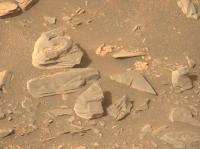
QUOTE (tau @ May 1 2022, 09:47 AM) Thank you, StargazeInWonder, I couldn't explain it better. Another example with relation to Mars: A solid piece of crystalline hematite (like the famous "blueberries") is steel gray and may appear blue after PCA transformation. Hematite powder is red (used as pigment Red ochre). The nature of the difference here is the different particle size, the mineral is the same. I had the same impression due to the smooth surfaces and thin layering. I hesitated to write it down until we get more details (high resolution images, mineral analyses). I'll mention again - might want to check the "Newark Basin Coring Project" out of Rutgers- They were able to correlate orbital orientation to rainfall, correlated to lake depth, such that blueshales are deep-water anoxic, redshales are shallow water-playa exposed and oxidized. Some terrestrial basins have tell-tale enrichment of rare-earth elements from the deepest lakestands, I'd be quite curious to see if any of those compounds turn up, or are detectable. Meanwhile- What's that? Everyone's looking at the silt layers, what's with the 'worm castings?"
Attached thumbnail(s)
|
|
|
|
|
|
|
May 1 2022, 04:45 PM
Post
#60
|
||
|
Member Group: Members Posts: 670 Joined: 9-May 21 From: Germany Member No.: 9017 |
QUOTE (HSchirmer @ May 1 2022, 03:19 PM) . . . Meanwhile- What's that? Everyone's looking at the silt layers, what's with the 'worm castings?" A SuperCam image of this little pile would be interesting, and a SuperCam image of the bumpy surface of this purple rock in the foreground of the sol 423 Mastcam-Z image below.
|
|
|
|
|
|
|
May 1 2022, 04:49 PM
Post
#61
|
|||
|
Member Group: Members Posts: 670 Joined: 9-May 21 From: Germany Member No.: 9017 |
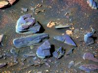
Here comes a sol 424 SuperCam RMI mosaic of the presumed siltstone/mudstone with sol 423 Mastcam-Z context.
The graininess in the bluish-gray parts of the SuperCam image is most likely image noise. Possible mineral grains are too small to be visible. If there are grains, their diameter should be less than 0.15 mm assuming that at least 3 pixels are necessary to resolve a grain. The vertical sequence of laser shots in the center of the SuperCam mosaic indicates that a chemical-mineralogical analysis is in progress.
|
||
|
|
|
||
|
May 1 2022, 07:48 PM
Post
#62
|
|
|
Member Group: Members Posts: 868 Joined: 9-September 17 From: UK Member No.: 8241 |
-------------------- |
|
|
|
|
May 1 2022, 09:26 PM
Post
#63
|
|
|
Senior Member Group: Members Posts: 2998 Joined: 30-October 04 Member No.: 105 |
QUOTE (HSchirmer @ May 1 2022, 08:19 AM) Snippity-snip Meanwhile- What's that? Everyone's looking at the silt layers, what's with the 'worm castings?" I'm not willing to stick my neck out on that just yet!! Aeolian weathering can create the strangest shapes!! --Bill -------------------- |
|
|
|
|
May 1 2022, 09:42 PM
Post
#64
|
|
|
Senior Member Group: Members Posts: 2998 Joined: 30-October 04 Member No.: 105 |
QUOTE (serpens @ May 1 2022, 12:54 AM) If you are right that the deposition was fallout in the lake prior to delta formation Bill then couldn't the banded layers reflect variations in oxygenation conditions within the lake? Assuming an abiotic influence, say periodic changes in cloud or ash cover affecting levels of UV at the surface and potentially shallow water. Absolutely. In (polluted) terrestrial waters you can have low dissolved oxygen due to BOD (Biological Oxygen Demand) and COD (Chemical Oxygen Demand). The chemistry of the water can scavenge oxygen. And still water in the bottom of a basin or Cup (  ) can certainly produce anoxic zones. ) can certainly produce anoxic zones. --Bill -------------------- |
|
|
|
|
May 2 2022, 09:54 AM
Post
#65
|
||||
|
Member Group: Members Posts: 670 Joined: 9-May 21 From: Germany Member No.: 9017 |
Sol 424 SuperCam RMI mosaic no. 2 with Mastcam-Z context and sol 422 Navcam context
|
|||
|
|
|
|||
|
May 2 2022, 10:04 AM
Post
#66
|
||||
|
Member Group: Members Posts: 670 Joined: 9-May 21 From: Germany Member No.: 9017 |
Sol 425 SuperCam RMI mosaic with sol 423 Mastcam-Z context and sol 422 Navcam context
|
|||
|
|
|
|||
|
May 2 2022, 11:29 AM
Post
#67
|
||
|
Member Group: Members Posts: 684 Joined: 24-July 15 Member No.: 7619 |
QUOTE (tau @ May 2 2022, 11:04 AM) Sol 425 SuperCam RMI mosaic ...
Interesting shapes- they remind me a bit of the raindrop casts you find in some eastern USA Triassic red shales. Anyone heard any guesses on what size raindrops on Mars would grow to? |
|
|
|
|
|
|
May 2 2022, 11:57 AM
Post
#68
|
|
 Member Group: Members Posts: 593 Joined: 20-April 05 Member No.: 279 |
QUOTE (HSchirmer @ May 2 2022, 12:29 PM) Anyone heard any guesses on what size raindrops on Mars would grow to? I know Ralph Lorenz has 'previous' on this matter! In brief - it appears to depend on the atmospheric pressure. Andy |
|
|
|
|
May 2 2022, 07:09 PM
Post
#69
|
||||
|
Solar System Cartographer Group: Members Posts: 10166 Joined: 5-April 05 From: Canada Member No.: 227 |
We have had some really nice panoramas posted by Damia and Thomas recently, certainly much better than I could manage. I have been playing with circular versions of them so here are some examples.
Damia, sol 419:
Thomas, sol 422:
and the same with some contrast enhancement and other processing:
And we just had another drive, this time to the east, looking like we will approach an interesting outcrop north of where we are now. Phil -------------------- ... because the Solar System ain't gonna map itself.
Also to be found posting similar content on https://mastodon.social/@PhilStooke Maps for download (free PD: https://upload.wikimedia.org/wikipedia/comm...Cartography.pdf NOTE: everything created by me which I post on UMSF is considered to be in the public domain (NOT CC, public domain) |
|||
|
|
|
|||
|
May 3 2022, 06:11 PM
Post
#70
|
|
|
Solar System Cartographer Group: Members Posts: 10166 Joined: 5-April 05 From: Canada Member No.: 227 |
Just reporting in from the MEPAG meeting. Ken Farley reports that the rover will now move back to the Three Forks area and up into Hawksbill Gap. It will survey outcrops on the way up, then sample them on the way down. At the end of 2022 it will be back at Three Forks and that may be the site of the first sample cache, because it is so flat and benign for operation of the later sample collection missions. Then Perseverance will climb onto the delta top for more sampling. It is possible that the cache will be closer to the crater Belva on the delta top, some time in 2023, but there is a desire to get a good cache safely deployed fairly soon. Later the rover moves to the main channel of the delta and finally up onto the crater rim in about 2024. A second cache would be further southwest after more sampling.
Phil -------------------- ... because the Solar System ain't gonna map itself.
Also to be found posting similar content on https://mastodon.social/@PhilStooke Maps for download (free PD: https://upload.wikimedia.org/wikipedia/comm...Cartography.pdf NOTE: everything created by me which I post on UMSF is considered to be in the public domain (NOT CC, public domain) |
|
|
|
|
May 3 2022, 08:08 PM
Post
#71
|
||
|
Solar System Cartographer Group: Members Posts: 10166 Joined: 5-April 05 From: Canada Member No.: 227 |
This is Damia's panorama for sol 419 (as posted above) but with enhanced contrast and adjusted colour. Changing contrast messes up the colour, which is why I make changes to it. I know it's not realistic.
I have not worked on the latest panorama, hoping someone else will do it first. Phil
-------------------- ... because the Solar System ain't gonna map itself.
Also to be found posting similar content on https://mastodon.social/@PhilStooke Maps for download (free PD: https://upload.wikimedia.org/wikipedia/comm...Cartography.pdf NOTE: everything created by me which I post on UMSF is considered to be in the public domain (NOT CC, public domain) |
|
|
|
|
|
|
May 4 2022, 02:23 AM
Post
#72
|
||
|
Senior Member Group: Members Posts: 1074 Joined: 21-September 07 From: Québec, Canada Member No.: 3908 |
Sol 425 RMastcam-Z (34mm):
|
|
|
|
|
|
|
May 5 2022, 06:56 AM
Post
#73
|
||
|
Solar System Cartographer Group: Members Posts: 10166 Joined: 5-April 05 From: Canada Member No.: 227 |
sol 426, a circular panorama with lots of aeolian bedforms AKA drifty-like ripply-like objects.
Phil
-------------------- ... because the Solar System ain't gonna map itself.
Also to be found posting similar content on https://mastodon.social/@PhilStooke Maps for download (free PD: https://upload.wikimedia.org/wikipedia/comm...Cartography.pdf NOTE: everything created by me which I post on UMSF is considered to be in the public domain (NOT CC, public domain) |
|
|
|
|
|
|
May 5 2022, 09:05 AM
Post
#74
|
||
|
Senior Member Group: Members Posts: 2429 Joined: 30-January 13 From: Penang, Malaysia. Member No.: 6853 |
More of those lovely aeolian bedforms (See Phil's post) this time after the drive on sol 428 (site 24-1970)
|
|
|
|
|
|
|
May 5 2022, 11:22 AM
Post
#75
|
|
|
Senior Member Group: Members Posts: 1619 Joined: 12-February 06 From: Bergerac - FR Member No.: 678 |
Sol 428 Navcam panoramic. Look at this very nice place !
-------------------- |
|
|
|
|
May 5 2022, 12:47 PM
Post
#76
|
||||
|
Member Group: Members Posts: 240 Joined: 18-July 06 Member No.: 981 |
QUOTE (tau @ May 1 2022, 05:49 PM) Here comes a sol 424 SuperCam RMI mosaic of the presumed siltstone/mudstone with sol 423 Mastcam-Z context. The graininess in the bluish-gray parts of the SuperCam image is most likely image noise. Possible mineral grains are too small to be visible. If there are grains, their diameter should be less than 0.15 mm assuming that at least 3 pixels are necessary to resolve a grain. The vertical sequence of laser shots in the center of the SuperCam mosaic indicates that a chemical-mineralogical analysis is in progress.
Very interesting. Rather than strata these layers have the appearance of striations given the uniformity of the mineralogy and almost invisible grains and a colour which seems to match that of other igneous rock in the region. It seems very unlikely that distinct layers deposited in different periods would appear so uniform and cohesive with uniformly microscopic grain size and exhibit such stable fractures. Admittedly the orientation seems wrong but could be the result of a kinetic event. Glaciation or rock glaciation might explain the unusual erosion evident in the geography of the delta front. Here's an example:
|
|||
|
|
|
|||
|
May 5 2022, 01:29 PM
Post
#77
|
|||
|
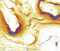
Member Group: Members Posts: 670 Joined: 9-May 21 From: Germany Member No.: 9017 |
The mineralogy of many rocks here is most likely not homogeneous.
There are color variations (bluish/purple) parallel to the layers. They are particularly well visible in multispectral images like this one in post #48. I would exclude a glacial influence on the shape of the rocks here. Here come some more multispectral images. The next three were taken around SuperCam RMI investigations. Sol 425 no. 1 Mastcam-Z left eye filter 0 raw image and filters 1 to 6 multispectral principal components
|
||
|
|
|
||
|
May 5 2022, 01:31 PM
Post
#78
|
|||
|
Member Group: Members Posts: 670 Joined: 9-May 21 From: Germany Member No.: 9017 |
Sol 425 no. 2 Mastcam-Z left eye filter 0 raw image and filters 1 to 6 multispectral principal components
|
||
|
|
|
||
|
May 5 2022, 01:33 PM
Post
#79
|
|||
|
Member Group: Members Posts: 670 Joined: 9-May 21 From: Germany Member No.: 9017 |
Sol 425 no. 3 Mastcam-Z left eye filter 0 raw image and filters 1 to 6 multispectral principal components
|
||
|
|
|
||
|
May 5 2022, 01:34 PM
Post
#80
|
|
|
Member Group: Members Posts: 670 Joined: 9-May 21 From: Germany Member No.: 9017 |
|
|
|
|
|
May 5 2022, 06:39 PM
Post
#81
|
|
|
Member Group: Members Posts: 868 Joined: 9-September 17 From: UK Member No.: 8241 |
-------------------- |
|
|
|
|
May 5 2022, 08:49 PM
Post
#82
|
||
|
Solar System Cartographer Group: Members Posts: 10166 Joined: 5-April 05 From: Canada Member No.: 227 |
Sol 427 panorama in circular form. I thought this area would be difficult to cross but it seems not. I only used the upper tier of tiles in the multi-tile image to save time.
Phil
-------------------- ... because the Solar System ain't gonna map itself.
Also to be found posting similar content on https://mastodon.social/@PhilStooke Maps for download (free PD: https://upload.wikimedia.org/wikipedia/comm...Cartography.pdf NOTE: everything created by me which I post on UMSF is considered to be in the public domain (NOT CC, public domain) |
|
|
|
|
|
|
May 5 2022, 09:15 PM
Post
#83
|
|||
|
Solar System Cartographer Group: Members Posts: 10166 Joined: 5-April 05 From: Canada Member No.: 227 |
And this is Damia's very nice panorama from sol 428 in circular form, with a closeup of the area around the rover. Still lots of terrain relief distortion in this. Thanks for a timely panorama, Damia.
Phil
-------------------- ... because the Solar System ain't gonna map itself.
Also to be found posting similar content on https://mastodon.social/@PhilStooke Maps for download (free PD: https://upload.wikimedia.org/wikipedia/comm...Cartography.pdf NOTE: everything created by me which I post on UMSF is considered to be in the public domain (NOT CC, public domain) |
||
|
|
|
||
|
May 5 2022, 11:29 PM
Post
#84
|
|
|
Member Group: Members Posts: 868 Joined: 9-September 17 From: UK Member No.: 8241 |
-------------------- |
|
|
|
|
May 6 2022, 09:24 PM
Post
#85
|
||||
|
Member Group: Members Posts: 670 Joined: 9-May 21 From: Germany Member No.: 9017 |
Two SuperCam RMI mosaics from sol 428 with Navcam context image
|
|||
|
|
|
|||
|
May 9 2022, 02:37 AM
Post
#86
|
||
|
Senior Member Group: Members Posts: 2429 Joined: 30-January 13 From: Penang, Malaysia. Member No.: 6853 |
A drive on Sol 432 takes the rover to site 24-2770
Trimmed this roughly assembled / processed end-of-drive tiled L-NavCam to remove a little image drop out. JSON drive data not yet available.
|
|
|
|
|
|
|
May 9 2022, 07:42 AM
Post
#87
|
|
|
Solar System Cartographer Group: Members Posts: 10166 Joined: 5-April 05 From: Canada Member No.: 227 |
Now the map is updated - a good drive out of the ripple area and out into the plains of Three Forks. According to the MEPAG presentation we will head for the bacon buffet now.
Phil -------------------- ... because the Solar System ain't gonna map itself.
Also to be found posting similar content on https://mastodon.social/@PhilStooke Maps for download (free PD: https://upload.wikimedia.org/wikipedia/comm...Cartography.pdf NOTE: everything created by me which I post on UMSF is considered to be in the public domain (NOT CC, public domain) |
|
|
|
|
May 9 2022, 06:00 PM
Post
#88
|
|
|
Senior Member Group: Members Posts: 2998 Joined: 30-October 04 Member No.: 105 |
Which map is updated, Phil? The last Route Map uodate ia 3May22.
-------------------- |
|
|
|
|
May 9 2022, 07:31 PM
Post
#89
|
|
|
Solar System Cartographer Group: Members Posts: 10166 Joined: 5-April 05 From: Canada Member No.: 227 |
I was referring to the JPL map:
https://mars.nasa.gov/mars2020/mission/where-is-the-rover/ It is updated after every drive, usually within half a day. Phil -------------------- ... because the Solar System ain't gonna map itself.
Also to be found posting similar content on https://mastodon.social/@PhilStooke Maps for download (free PD: https://upload.wikimedia.org/wikipedia/comm...Cartography.pdf NOTE: everything created by me which I post on UMSF is considered to be in the public domain (NOT CC, public domain) |
|
|
|
|
May 9 2022, 11:52 PM
Post
#90
|
||
|
Member Group: Members Posts: 714 Joined: 3-January 08 Member No.: 3995 |
Has Perseverance taken RIMFAX scans since it was at South Séítah? A scan around sol 419-422 could help determine whether the crater-floor volcanic unit onlaps or underlies the sedimentary beds of the delta.
Edit: Two possibilities:
|
|
|
|
|
|
|
May 10 2022, 02:39 AM
Post
#91
|
|
|
Solar System Cartographer Group: Members Posts: 10166 Joined: 5-April 05 From: Canada Member No.: 227 |
RIMFAX is used on almost every drive. A place as significant as this will certainly be probed by RIMFAX, but it may be quite a while before we get to hear about the results.
Phil -------------------- ... because the Solar System ain't gonna map itself.
Also to be found posting similar content on https://mastodon.social/@PhilStooke Maps for download (free PD: https://upload.wikimedia.org/wikipedia/comm...Cartography.pdf NOTE: everything created by me which I post on UMSF is considered to be in the public domain (NOT CC, public domain) |
|
|
|
|
May 11 2022, 12:36 PM
Post
#92
|
||||
|
Member Group: Members Posts: 670 Joined: 9-May 21 From: Germany Member No.: 9017 |
Sol 425 SuperCam Remote Micro-Imager mosaic with Mastcam-Z context and sol 422 Navcam context
Here is a link to a multispectral image of the Mastcam-Z context
|
|||
|
|
|
|||
|
May 11 2022, 11:37 PM
Post
#93
|
|
|
Member Group: Members Posts: 362 Joined: 13-April 06 From: Malta Member No.: 741 |
Do we know what slope angles will Percy have to drive climbing up the delta?
|
|
|
|
|
May 12 2022, 07:12 AM
Post
#94
|
||
|
Solar System Cartographer Group: Members Posts: 10166 Joined: 5-April 05 From: Canada Member No.: 227 |
A circular panorama for sol 432, coming back into the Three Forks area.
Phil
-------------------- ... because the Solar System ain't gonna map itself.
Also to be found posting similar content on https://mastodon.social/@PhilStooke Maps for download (free PD: https://upload.wikimedia.org/wikipedia/comm...Cartography.pdf NOTE: everything created by me which I post on UMSF is considered to be in the public domain (NOT CC, public domain) |
|
|
|
|
|
|
May 12 2022, 08:10 AM
Post
#95
|
||
|
Senior Member Group: Members Posts: 2429 Joined: 30-January 13 From: Penang, Malaysia. Member No.: 6853 |
After the short drive on Sol 434
|
|
|
|
|
|
|
May 12 2022, 11:58 AM
Post
#96
|
|||
|
Member Group: Members Posts: 670 Joined: 9-May 21 From: Germany Member No.: 9017 |
QUOTE (Julius @ May 12 2022, 01:37 AM) Do we know what slope angles will Percy have to drive climbing up the delta? Here is a map of slope angles derived from a digital terrain model with a horizontal resolution of 1 m. Local small-scale slope angles may be greater than shown on the map. Thick elevation contour lines every 10 m, thin lines every meter. The steepest slope Curiosity has climbed so far in Gale crater was about 31 degrees to my knowledge, most probably on solid ground. I wouldn't try this with Perseverance on a scree slope.
|
||
|
|
|
||
|
May 12 2022, 05:59 PM
Post
#97
|
|
|
Forum Contributor Group: Members Posts: 1372 Joined: 8-February 04 From: North East Florida, USA. Member No.: 11 |
Don't forget Perseverance's wheels have twice as many treads as Curiosity's wheels, so that could mean less slippage when traversing slopes ?
|
|
|
|
|
May 12 2022, 08:44 PM
Post
#98
|
||
|
Solar System Cartographer Group: Members Posts: 10166 Joined: 5-April 05 From: Canada Member No.: 227 |
Sol 433 circular panorama. A good landing strip for the sample return lander!
Phil
-------------------- ... because the Solar System ain't gonna map itself.
Also to be found posting similar content on https://mastodon.social/@PhilStooke Maps for download (free PD: https://upload.wikimedia.org/wikipedia/comm...Cartography.pdf NOTE: everything created by me which I post on UMSF is considered to be in the public domain (NOT CC, public domain) |
|
|
|
|
|
|
May 13 2022, 02:57 AM
Post
#99
|
|
|
Member Group: Members Posts: 233 Joined: 14-January 22 Member No.: 9140 |
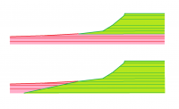
Given tau's very nice topo map, it looks like Perseverance can reach some delta layers by climbing a slope no steeper than 6° in the direction of motion. That doesn't account for the need to negotiate some dunes in the early going, which is also tricky. But it looks like nothing harder than what Curiosity has already done.
|
|
|
|
|
May 13 2022, 03:45 AM
Post
#100
|
||
|
Solar System Cartographer Group: Members Posts: 10166 Joined: 5-April 05 From: Canada Member No.: 227 |
This is the description of future activities shown by Ken Farley at MEPAG (public information, will be online shortly). We are at point 4 now.
Phil
-------------------- ... because the Solar System ain't gonna map itself.
Also to be found posting similar content on https://mastodon.social/@PhilStooke Maps for download (free PD: https://upload.wikimedia.org/wikipedia/comm...Cartography.pdf NOTE: everything created by me which I post on UMSF is considered to be in the public domain (NOT CC, public domain) |
|
|
|
|
|
 |

|
Lo-Fi Version | Time is now: 23rd May 2024 - 10:37 AM |
|
RULES AND GUIDELINES Please read the Forum Rules and Guidelines before posting. IMAGE COPYRIGHT |
OPINIONS AND MODERATION Opinions expressed on UnmannedSpaceflight.com are those of the individual posters and do not necessarily reflect the opinions of UnmannedSpaceflight.com or The Planetary Society. The all-volunteer UnmannedSpaceflight.com moderation team is wholly independent of The Planetary Society. The Planetary Society has no influence over decisions made by the UnmannedSpaceflight.com moderators. |
SUPPORT THE FORUM Unmannedspaceflight.com is funded by the Planetary Society. Please consider supporting our work and many other projects by donating to the Society or becoming a member. |
|