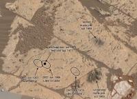
The Top of Vera Rubin Ridge Part 2, Site 67-73, sol 1944-2297, 24 Jan 2018-22 Jan 2019 |

The Top of Vera Rubin Ridge Part 2, Site 67-73, sol 1944-2297, 24 Jan 2018-22 Jan 2019 |
 Jan 24 2018, 08:59 PM Jan 24 2018, 08:59 PM
Post
#1
|
||
 Senior Member  Group: Members Posts: 2429 Joined: 30-January 13 From: Penang, Malaysia. Member No.: 6853 |
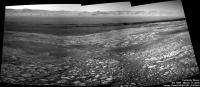
Drive during 1944, L-NavCam pan roughly stitched in MS ICE be should be good to help pinpoint the location. (the plan called for a 25 meter drive south)
(delete after proper version is posted)
|
|
 |
 
|
|
 |
|
Jan 25 2018, 12:29 AM
Post
#2
|
||
|
Solar System Cartographer Group: Members Posts: 10166 Joined: 5-April 05 From: Canada Member No.: 227 |
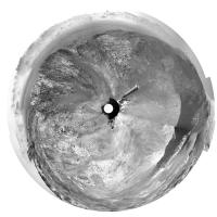
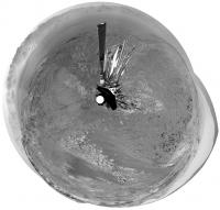
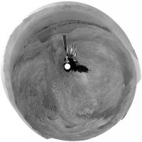
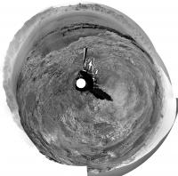
Paul's sol 1944 panorama in circular form.
Phil
-------------------- ... because the Solar System ain't gonna map itself.
Also to be found posting similar content on https://mastodon.social/@PhilStooke Maps for download (free PD: https://upload.wikimedia.org/wikipedia/comm...Cartography.pdf NOTE: everything created by me which I post on UMSF is considered to be in the public domain (NOT CC, public domain) |
|
|
|
|
|
|
Jan 25 2018, 02:11 AM
Post
#3
|
|
 Administrator Group: Admin Posts: 5172 Joined: 4-August 05 From: Pasadena, CA, USA, Earth Member No.: 454 |
New thread! Please keep sharing sol 1943 self-portrait work in the previous thread, and carry on discussing the ongoing mission here. Curiosity should be driving east across the top of the ridge for a little bit, chasing interesting CRISM pixels, before driving down into the valley. If we're lucky we might see a little action with restoring the drill to service, too.
-------------------- My website - My Patreon - @elakdawalla on Twitter - Please support unmannedspaceflight.com by donating here.
|
|
|
|
|
Jan 25 2018, 11:05 PM
Post
#4
|
|
 Senior Member Group: Members Posts: 1619 Joined: 12-February 06 From: Bergerac - FR Member No.: 678 |
Sol 1944 Navcam pan
 Do we have a name for "the Valley-Behind-the-Ridge" (my temporay proposition for this place) ? Do we have a name for "the Valley-Behind-the-Ridge" (my temporay proposition for this place) ?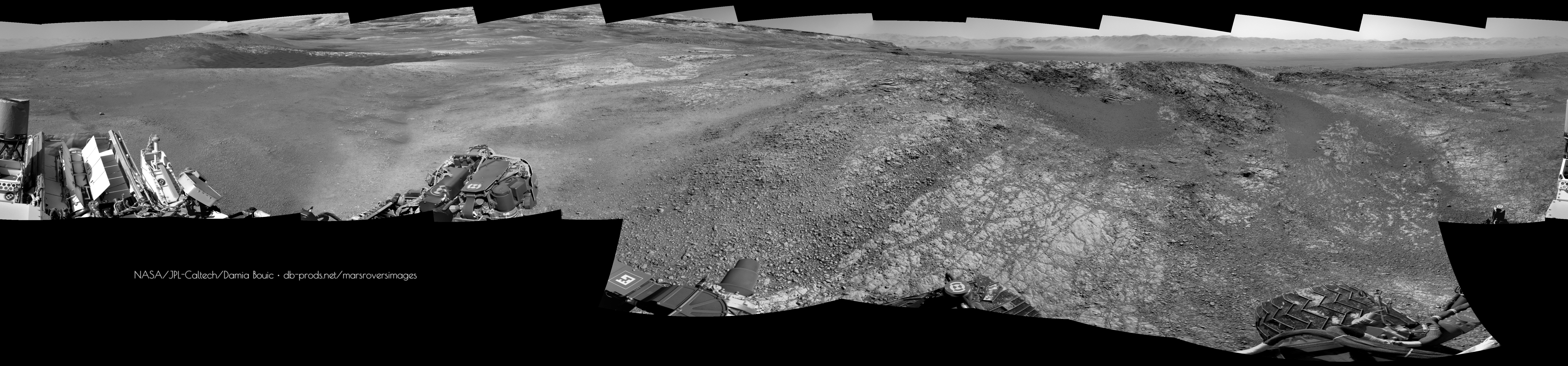
-------------------- |
|
|
|
|
Jan 25 2018, 11:36 PM
Post
#5
|
|
|
Senior Member Group: Members Posts: 2346 Joined: 7-December 12 Member No.: 6780 |
The most common informal name seems to be "Phyllosilicate Trough", see e.g. here.
|
|
|
|
|
Jan 26 2018, 12:33 AM
Post
#6
|
|
 Member Group: Members Posts: 684 Joined: 24-July 15 Member No.: 7619 |
QUOTE (Gerald @ Jan 25 2018, 11:36 PM)  The most common informal name seems to be "Phyllosilicate Trough", Since Phyllo means "sheets/dough" and silica means hard, are we going to get placenames based on pastries? |
|
|
|
|
Jan 26 2018, 11:10 AM
Post
#7
|
|
|
Senior Member Group: Members Posts: 2346 Joined: 7-December 12 Member No.: 6780 |
The phyllosilicates form a large class of silicate minerals, with the clay minerals as a subclass. Phyllosilicates have been identified by CRISM in the Phyllosilicate Trough (see e.g. fig. 6 on page 1723 in the paper).
|
|
|
|
|
Jan 27 2018, 09:42 AM
Post
#8
|
||
|
Senior Member Group: Members Posts: 2429 Joined: 30-January 13 From: Penang, Malaysia. Member No.: 6853 |
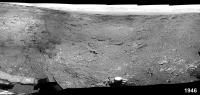
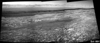
Drive on 1946, here is what I could salvage from a rough stitch of the available L-NavCam's, hopefully it may assist in refining the location (mods to delete when the full version is posted)
|
|
|
|
|
|
|
Jan 27 2018, 11:46 AM
Post
#9
|
|
|
Senior Member Group: Members Posts: 1619 Joined: 12-February 06 From: Bergerac - FR Member No.: 678 |
Incoming !
Edit : complete 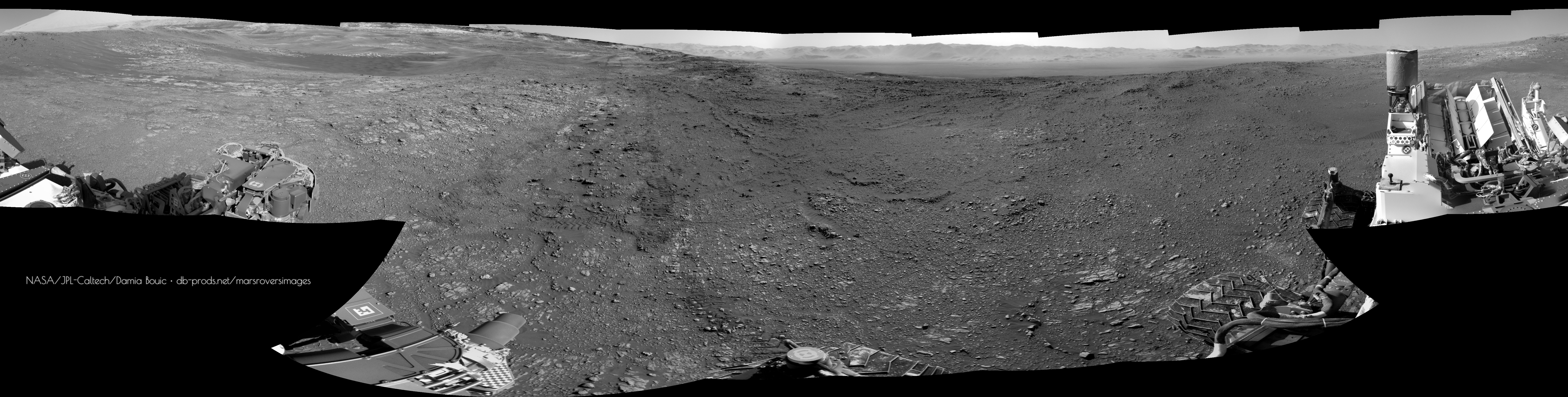
-------------------- |
|
|
|
|
Jan 27 2018, 07:39 PM
Post
#10
|
||
|
Solar System Cartographer Group: Members Posts: 10166 Joined: 5-April 05 From: Canada Member No.: 227 |
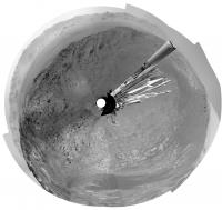
For location purposes I did a rough patch of Damia's panorama and made a circular version:
Phil -------------------- ... because the Solar System ain't gonna map itself.
Also to be found posting similar content on https://mastodon.social/@PhilStooke Maps for download (free PD: https://upload.wikimedia.org/wikipedia/comm...Cartography.pdf NOTE: everything created by me which I post on UMSF is considered to be in the public domain (NOT CC, public domain) |
|
|
|
|
|
|
Jan 29 2018, 09:03 AM
Post
#11
|
||
|
Senior Member Group: Members Posts: 2429 Joined: 30-January 13 From: Penang, Malaysia. Member No.: 6853 |
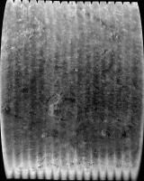
A long distance RMI mosaic, roughly assembled from 9 overlapping images acquired on sol 1948.
The early pointing data on Joe Knapp's image page suggests that it is located Southwest of the rover, if confirmed then it could be a valley Mesa or a section the north side of 'Phyllosillicate Valley'. I see a possible candidate on the NavCam images, but my monitor is poor (like my aging eyes). It could be mentioned in the weekend plan, but I've not found it yet. Thankfully we often get associated MastCam context frames with these image sets, hopefully we'll see it soon so we can establish the actual location.
EDIT: As often happens, another image from this set has come down which extends it to the left side a little. I wont flood the server by posting the updated version. Maybe we will see one of those rather nice pansharpened versions (hint) providing the MastCam images have enough detail
|
|
|
|
|
|
|
Jan 30 2018, 01:53 AM
Post
#12
|
||
|
Senior Member Group: Members Posts: 2429 Joined: 30-January 13 From: Penang, Malaysia. Member No.: 6853 |
Looks like a nice drive (>20 meters?) on sol 1949. MS ICE does not want to play ball with the available images, but there is a lovely view West of the rover's tracks as it drove back onto the top of the ridge. Looking forward to seeing the full pan with a nice view of what awaits us in the valley.
|
|
|
|
|
|
|
Jan 30 2018, 11:42 AM
Post
#13
|
|
|
Senior Member Group: Members Posts: 1619 Joined: 12-February 06 From: Bergerac - FR Member No.: 678 |
Sol 1949 Navcam panoramic.
-------------------- |
|
|
|
|
Jan 30 2018, 06:27 PM
Post
#14
|
||
|
Solar System Cartographer Group: Members Posts: 10166 Joined: 5-April 05 From: Canada Member No.: 227 |
I roughly patched Damia's panorama for location purposes - here is a circular projection of it.
Phil
-------------------- ... because the Solar System ain't gonna map itself.
Also to be found posting similar content on https://mastodon.social/@PhilStooke Maps for download (free PD: https://upload.wikimedia.org/wikipedia/comm...Cartography.pdf NOTE: everything created by me which I post on UMSF is considered to be in the public domain (NOT CC, public domain) |
|
|
|
|
|
|
Jan 30 2018, 11:45 PM
Post
#15
|
|
|
Member Group: Members Posts: 122 Joined: 19-June 07 Member No.: 2455 |
|
|
|
|
|
Jan 31 2018, 12:15 PM
Post
#16
|
||
|
Senior Member Group: Members Posts: 2429 Joined: 30-January 13 From: Penang, Malaysia. Member No.: 6853 |
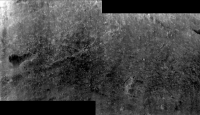
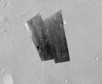
The wide exposure variations once again defeated MS ICE on the sol 1950 post drive L-NavCams. I managed to salvage this small section, hopefully it will assist in narrowing down the location until the full version is posted.
|
|
|
|
|
|
|
Jan 31 2018, 11:03 PM
Post
#17
|
|
|
Senior Member Group: Members Posts: 1619 Joined: 12-February 06 From: Bergerac - FR Member No.: 678 |
Don't give up Paul. Maybe try a different stitching software.
Sol 1950 Navcam panoramic. The visibility is so good we can nearly touch the mountains of Gale crater rim ! 
-------------------- |
|
|
|
|
Feb 1 2018, 01:18 AM
Post
#18
|
|
|
Senior Member Group: Members Posts: 2429 Joined: 30-January 13 From: Penang, Malaysia. Member No.: 6853 |
QUOTE (Ant103 @ Feb 1 2018, 07:03 AM) Don't give up Paul. Maybe try a different stitching software. Beautifully crafted panorama Damia I do hope that one day I can learn how to use some different software... Thankfully there is always lots of inspiration in this forum
|
|
|
|
|
Feb 1 2018, 01:22 AM
Post
#19
|
|
|
Administrator Group: Admin Posts: 5172 Joined: 4-August 05 From: Pasadena, CA, USA, Earth Member No.: 454 |
QUOTE (PaulH51 @ Jan 31 2018, 04:15 AM) The wide exposure variations once again defeated MS ICE I have sometimes found that I can encourage ICE to work by doing some preliminary exposure adjustment to better match adjacent frames.-------------------- My website - My Patreon - @elakdawalla on Twitter - Please support unmannedspaceflight.com by donating here.
|
|
|
|
|
Feb 1 2018, 01:39 AM
Post
#20
|
|
|
Senior Member Group: Members Posts: 2429 Joined: 30-January 13 From: Penang, Malaysia. Member No.: 6853 |
QUOTE (elakdawalla @ Feb 1 2018, 09:22 AM) I have sometimes found that I can encourage ICE to work by doing some preliminary exposure adjustment to better match adjacent frames. I did try that with this batch, maybe I overdid the lightening of the darker images... More practice needed |
|
|
|
|
Feb 1 2018, 10:56 AM
Post
#21
|
|
|
Senior Member Group: Members Posts: 1619 Joined: 12-February 06 From: Bergerac - FR Member No.: 678 |
Sol 1950 Mastcam34 driving direction pan. Looks like some new features are visibles here.
-------------------- |
|
|
|
|
Feb 1 2018, 06:10 PM
Post
#22
|
||
|
Solar System Cartographer Group: Members Posts: 10166 Joined: 5-April 05 From: Canada Member No.: 227 |
Damia's panorama in circular projection - rover tracks are visible at lower left, on the edge of the dark-floored depression.
Phil
-------------------- ... because the Solar System ain't gonna map itself.
Also to be found posting similar content on https://mastodon.social/@PhilStooke Maps for download (free PD: https://upload.wikimedia.org/wikipedia/comm...Cartography.pdf NOTE: everything created by me which I post on UMSF is considered to be in the public domain (NOT CC, public domain) |
|
|
|
|
|
|
Feb 3 2018, 09:13 PM
Post
#23
|
|
 Member Group: Members Posts: 810 Joined: 3-June 04 From: Brittany, France Member No.: 79 |
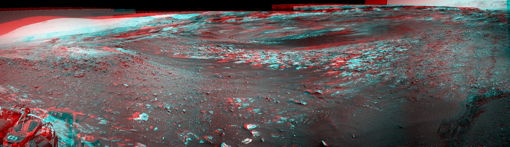
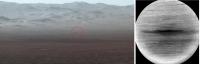
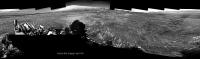
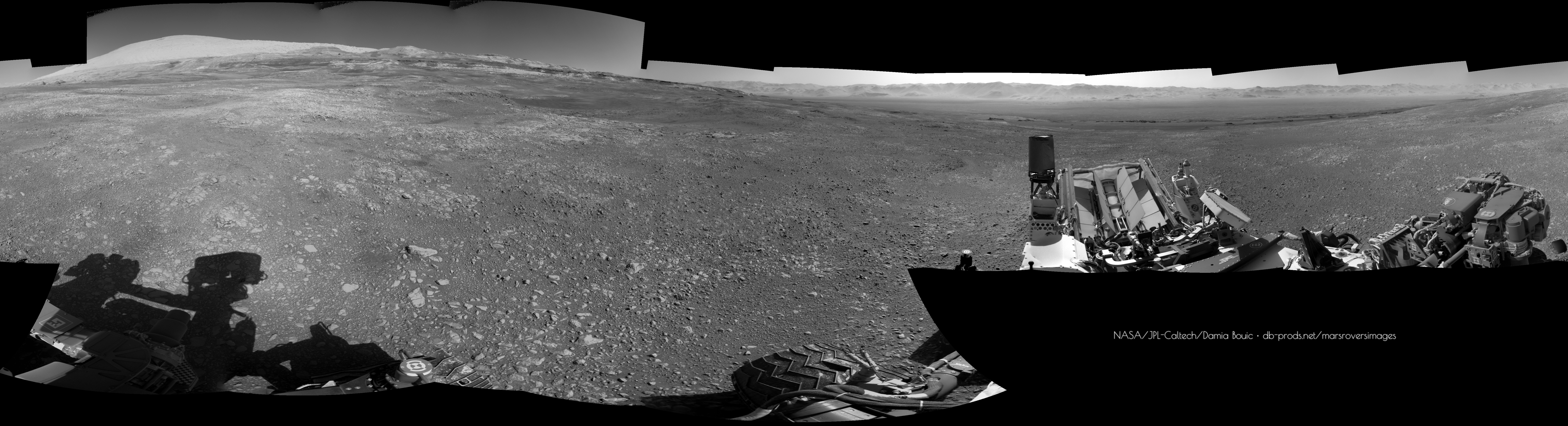
Postcard from Mars: with the particularly low atmospheric opacity these days, we have a crystal-clear view on the distant rim of Gale crater. What a vista!
This is a section of the sol 1950 NavCamR panorama with an extended sky. 
-------------------- |
|
|
|
|
Feb 3 2018, 09:36 PM
Post
#24
|
|
|
Senior Member Group: Members Posts: 3516 Joined: 4-November 05 From: North Wales Member No.: 542 |
A stupendous view indeed. It would be a particularly good one on which to mark the whole route travelled so far. I'm especially enjoying the reminders of earlier parts of the journey, such as the reappearance of the little hill to the east I used to call 'Dumgoyne' now seen from above whereas we were looking up at it from Yellowknife Bay.
|
|
|
|
|
Feb 4 2018, 03:41 PM
Post
#25
|
|
|
Member Group: Members Posts: 810 Joined: 3-June 04 From: Brittany, France Member No.: 79 |
QUOTE (ngunn @ Feb 3 2018, 10:36 PM) A stupendous view indeed. It would be a particularly good one on which to mark the whole route travelled so far. Here it is!  I used the recent JPL Press Release as a reference. I used the recent JPL Press Release as a reference.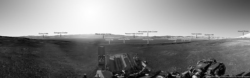
-------------------- |
|
|
|
|
Feb 5 2018, 08:37 AM
Post
#26
|
||
|
Senior Member Group: Members Posts: 2429 Joined: 30-January 13 From: Penang, Malaysia. Member No.: 6853 |
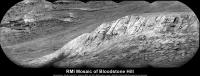
QUOTE (neo56 @ Feb 4 2018, 11:41 PM) Here it is! Very nice Thomas I'm so pleased they named some new features, particularly the large crater in the western rim wall, it's long been a landmark for me to decide where the rover was pointing. I hope they continue to release the names of the vales, gorges and Mesa's etc in the months and years ahead, it makes it so much more enjoyable to follow along and the share the mission with others.Meanwhile on Mars: sol 1955: 5 frame RMI mosaic of 'Bloodstone Hill' (roughly assembled in MS ICE), I guess there could be more images, but this is all they had when I processed these
|
|
|
|
|
|
|
Feb 5 2018, 06:59 PM
Post
#27
|
|
|
Member Group: Members Posts: 684 Joined: 24-July 15 Member No.: 7619 |
QUOTE (elakdawalla @ Feb 1 2018, 01:22 AM) I have sometimes found that I can encourage ICE to work by doing some preliminary exposure adjustment to better match adjacent frames. Well, you might try a "suture" - a small image created from the edges of adjacent images, manually matching scale and exposure. This roughly re-creates the "identify 3 match points" that was common in old camera stitch software. |
|
|
|
|
Feb 8 2018, 09:16 AM
Post
#28
|
|
|
Senior Member Group: Members Posts: 2429 Joined: 30-January 13 From: Penang, Malaysia. Member No.: 6853 |
Thanks. I'll see if I can find out more about that 'suture' process
EDIT : No drive on sol 1957, but the rover took another NavCam 360, so I have deleted the roughly stitched pan I posted earlier as it's the same as the one posted on 1950 |
|
|
|
|
Feb 8 2018, 07:17 PM
Post
#29
|
|
|
Member Group: Members Posts: 684 Joined: 24-July 15 Member No.: 7619 |
QUOTE (PaulH51 @ Feb 8 2018, 09:16 AM) Thanks. I'll see if I can find out more about that 'suture' process The other suggestion, see if you can dig up a copy of Canon's Photostitch, circa 2003 that had the incredibly useful ability to set manually forced match points. I've got the .iso somewhere.... |
|
|
|
|
Feb 10 2018, 03:10 AM
Post
#30
|
||
|
Senior Member Group: Members Posts: 2429 Joined: 30-January 13 From: Penang, Malaysia. Member No.: 6853 |
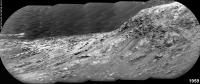
One of the telephoto RMI mosaics from sol 1959, roughly assembled in MS ICE with a little pre stitch processing on some of the frames. The 1959 mission update states that some of these long distance mosaics were checking various steep slopes to look for evidence of grain motion downhill.
|
|
|
|
|
|
|
Feb 10 2018, 11:07 AM
Post
#31
|
|
|
Senior Member Group: Members Posts: 1619 Joined: 12-February 06 From: Bergerac - FR Member No.: 678 |
Sol 1957 (and 1959, one frame) panoramic.
-------------------- |
|
|
|
|
Feb 12 2018, 09:18 AM
Post
#32
|
|
|
Senior Member Group: Members Posts: 2429 Joined: 30-January 13 From: Penang, Malaysia. Member No.: 6853 |
Looks like they have completed the long awaited drive to the NE on 1962, path looks like a dogs leg, but the point to point may be around 50m. Still playing with ICE
 |
|
|
|
|
Feb 12 2018, 11:33 AM
Post
#33
|
|
|
Member Group: Members Posts: 810 Joined: 3-June 04 From: Brittany, France Member No.: 79 |
I stitched a couple of MC100 pictures focusing on the foothills and outcrops on sol 1957 and 1959. Photos are taken at ~12h local time, so not a lot of contrast.
   I also combined a recent RMI mosaic taken on sol 1961 with a MC100 picture to show the location of the outcrop that was imaged: 
-------------------- |
|
|
|
|
Feb 12 2018, 07:39 PM
Post
#34
|
|
|
Solar System Cartographer Group: Members Posts: 10166 Joined: 5-April 05 From: Canada Member No.: 227 |
Great pictures, everybody - what an amazing place we are coming to! The next few years are going to be spectacular.
Phil -------------------- ... because the Solar System ain't gonna map itself.
Also to be found posting similar content on https://mastodon.social/@PhilStooke Maps for download (free PD: https://upload.wikimedia.org/wikipedia/comm...Cartography.pdf NOTE: everything created by me which I post on UMSF is considered to be in the public domain (NOT CC, public domain) |
|
|
|
|
Feb 13 2018, 11:48 AM
Post
#35
|
|
|
Senior Member Group: Members Posts: 1619 Joined: 12-February 06 From: Bergerac - FR Member No.: 678 |
Sol 1962 Navcam pan :
-------------------- |
|
|
|
|
Feb 13 2018, 01:37 PM
Post
#36
|
||
|
Senior Member Group: Members Posts: 2429 Joined: 30-January 13 From: Penang, Malaysia. Member No.: 6853 |
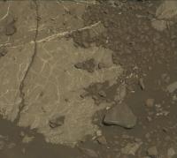
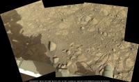
Potential Drill Site?
L-MastCam arm workspace: Sol 1962 (MS ICE) minimal processing, some nice surface details on the exposed bedrock Fingers crossed they get the all clear to drill... Been a while
|
|
|
|
|
|
|
Feb 13 2018, 04:48 PM
Post
#37
|
|
|
Member Group: Members Posts: 810 Joined: 3-June 04 From: Brittany, France Member No.: 79 |
Gregory Dubos, who works at JPL on Curiosity, recently tweeted (@astroptere) that his team is currently preparing a new drilling attempt.
-------------------- |
|
|
|
|
Feb 13 2018, 08:39 PM
Post
#38
|
||
|
Solar System Cartographer Group: Members Posts: 10166 Joined: 5-April 05 From: Canada Member No.: 227 |
Damia's new panorama for sol 1962 in circular form.
Phil
-------------------- ... because the Solar System ain't gonna map itself.
Also to be found posting similar content on https://mastodon.social/@PhilStooke Maps for download (free PD: https://upload.wikimedia.org/wikipedia/comm...Cartography.pdf NOTE: everything created by me which I post on UMSF is considered to be in the public domain (NOT CC, public domain) |
|
|
|
|
|
|
Feb 13 2018, 10:55 PM
Post
#39
|
|
|
Senior Member Group: Members Posts: 2429 Joined: 30-January 13 From: Penang, Malaysia. Member No.: 6853 |
QUOTE (neo56 @ Feb 14 2018, 12:48 AM) Gregory Dubos, who works at JPL on Curiosity, recently tweeted (@astroptere) that his team is currently preparing a new drilling attempt. Good spot Thomas The possibility of using the drill at this location is also addressed in the sol 1963 mission update |
|
|
|
|
Feb 16 2018, 01:56 AM
Post
#40
|
||
|
Senior Member Group: Members Posts: 2429 Joined: 30-January 13 From: Penang, Malaysia. Member No.: 6853 |
The 1965 mission update calls for a 360 MastCam mosaic, maybe to support that they have also acquired a NavCam set of the Rover deck
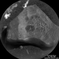
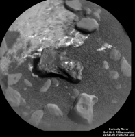
Should be an impressive panorama from this vantage point.There is also a nice candidate for another iron-nickel meteorite in the arm workspace, the team are going to be here for a while if the ground is suitable to attempt drilling, so maybe they will give it a zap to see if it is iron, I hope the coating on its topside is not dust, maybe wishful thinking that is a ferrous oxide, or maybe where is was in contact with a rock (if it was buried in the sediments)
Attached thumbnail(s)
|
|
|
|
|
|
|
Feb 20 2018, 08:21 PM
Post
#41
|
||
|
Solar System Cartographer Group: Members Posts: 10166 Joined: 5-April 05 From: Canada Member No.: 227 |
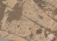
This is part of Paul's workspace mosaic (with a little patch), posted earlier, annotated with recent activities.
Phil
-------------------- ... because the Solar System ain't gonna map itself.
Also to be found posting similar content on https://mastodon.social/@PhilStooke Maps for download (free PD: https://upload.wikimedia.org/wikipedia/comm...Cartography.pdf NOTE: everything created by me which I post on UMSF is considered to be in the public domain (NOT CC, public domain) |
|
|
|
|
|
|
Feb 21 2018, 10:17 PM
Post
#42
|
|
|
Administrator Group: Admin Posts: 5172 Joined: 4-August 05 From: Pasadena, CA, USA, Earth Member No.: 454 |
FYI (from Ashwin), the smaller pile (upper one in your view) is the sieved (fine-grained) sample, the larger pile the unsieved (coarse-grained) sample.
Curiosity update forthcoming. -------------------- My website - My Patreon - @elakdawalla on Twitter - Please support unmannedspaceflight.com by donating here.
|
|
|
|
|
Feb 22 2018, 12:12 AM
Post
#43
|
|
|
Solar System Cartographer Group: Members Posts: 10166 Joined: 5-April 05 From: Canada Member No.: 227 |
Thanks, I was trying to decide which was which.
Phil -------------------- ... because the Solar System ain't gonna map itself.
Also to be found posting similar content on https://mastodon.social/@PhilStooke Maps for download (free PD: https://upload.wikimedia.org/wikipedia/comm...Cartography.pdf NOTE: everything created by me which I post on UMSF is considered to be in the public domain (NOT CC, public domain) |
|
|
|
|
Feb 23 2018, 09:27 AM
Post
#44
|
|
|
Senior Member Group: Members Posts: 2429 Joined: 30-January 13 From: Penang, Malaysia. Member No.: 6853 |
Go For Drilling at "Lake Orcadie" Link
|
|
|
|
|
Feb 27 2018, 07:40 PM
Post
#45
|
||
|
Solar System Cartographer Group: Members Posts: 10166 Joined: 5-April 05 From: Canada Member No.: 227 |
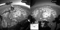
Suffering through a bit of an image diet here, but it looks like we had a successful drill on 1977. Here's a comparison of images 2 sols apart.
Phil
-------------------- ... because the Solar System ain't gonna map itself.
Also to be found posting similar content on https://mastodon.social/@PhilStooke Maps for download (free PD: https://upload.wikimedia.org/wikipedia/comm...Cartography.pdf NOTE: everything created by me which I post on UMSF is considered to be in the public domain (NOT CC, public domain) |
|
|
|
|
|
|
Feb 28 2018, 07:34 AM
Post
#46
|
||
|
Senior Member Group: Members Posts: 2429 Joined: 30-January 13 From: Penang, Malaysia. Member No.: 6853 |
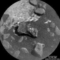
QUOTE (Phil Stooke @ Feb 28 2018, 03:40 AM) Suffering through a bit of an image diet here.... Good eyes as always Phil Looks like the drought may have been eased, with the arrival of 100+ L-MastCam full frames from the 360 pan acquired on sol 1965, although I would rather have got the NavCams from the recent pre-FED & FED activities. But we did get a bonus in a sol 1971 RMI of what appears to be (to my amateur eyes) suspiciously like another iron meteorite candidate in the current workspace The 360 pan frames are all Bayer encoded, so I cant do them any justice, hopefully the image wizards here will be able to use those and the NavCam Deck images to make another masterpiece
|
|
|
|
|
|
|
Feb 28 2018, 09:13 PM
Post
#47
|
|
|
Solar System Cartographer Group: Members Posts: 10166 Joined: 5-April 05 From: Canada Member No.: 227 |
-------------------- ... because the Solar System ain't gonna map itself.
Also to be found posting similar content on https://mastodon.social/@PhilStooke Maps for download (free PD: https://upload.wikimedia.org/wikipedia/comm...Cartography.pdf NOTE: everything created by me which I post on UMSF is considered to be in the public domain (NOT CC, public domain) |
|
|
|
|
Feb 28 2018, 09:23 PM
Post
#48
|
|
|
Senior Member Group: Members Posts: 2086 Joined: 13-February 10 From: Ontario Member No.: 5221 |
High five to the whole team! The drought is (almost) over!
Only step 1, though, as this press release explains. https://www.jpl.nasa.gov/news/news.php?feature=7070 |
|
|
|
|
Feb 28 2018, 11:34 PM
Post
#49
|
|
|
Senior Member Group: Members Posts: 2429 Joined: 30-January 13 From: Penang, Malaysia. Member No.: 6853 |
QUOTE (Explorer1 @ Mar 1 2018, 05:23 AM) ...Only step 1, though.... Great news, really looking forward to the next steps in that process |
|
|
|
|
Mar 1 2018, 05:22 AM
Post
#50
|
|
|
Senior Member Group: Members Posts: 2429 Joined: 30-January 13 From: Penang, Malaysia. Member No.: 6853 |
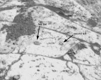
Going to try drilling again, need to be deeper to obtain a sample, but first the DRT and APXS will assess the new target (Lake Orcadie 2) roughly 7 inches to the right of the first hole. Link
|
|
|
|
|
Mar 1 2018, 11:17 PM
Post
#51
|
||
|
Solar System Cartographer Group: Members Posts: 10166 Joined: 5-April 05 From: Canada Member No.: 227 |
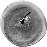
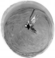
Sol 1979, DRT at Lake Orcadie 2.
Phil
-------------------- ... because the Solar System ain't gonna map itself.
Also to be found posting similar content on https://mastodon.social/@PhilStooke Maps for download (free PD: https://upload.wikimedia.org/wikipedia/comm...Cartography.pdf NOTE: everything created by me which I post on UMSF is considered to be in the public domain (NOT CC, public domain) |
|
|
|
|
|
|
Mar 3 2018, 10:22 PM
Post
#52
|
||
|
Senior Member Group: Members Posts: 2429 Joined: 30-January 13 From: Penang, Malaysia. Member No.: 6853 |
Checking-Out the Phyllosilicate Trough to the SW of the rover (Telephoto RMI mosaic assembled in MS ICE, sol 1981)
|
|
|
|
|
|
|
Mar 4 2018, 01:28 AM
Post
#53
|
||||
|
Senior Member Group: Members Posts: 2429 Joined: 30-January 13 From: Penang, Malaysia. Member No.: 6853 |
Three of the recent ChemCam targets from sols 1980 & 1981.
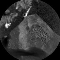
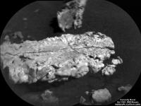
A lovely looking vein (calcium sulfate?) A revisit to 'Black Cuillin' and yet another candidate iron meteorite (judging by the bright laser spots)... (mosaics assembled in MS ICE) I think I may need to make a list of these candidates
|
|||
|
|
|
|||
|
Mar 4 2018, 01:30 PM
Post
#54
|
||
|
Senior Member Group: Members Posts: 2429 Joined: 30-January 13 From: Penang, Malaysia. Member No.: 6853 |
Felt compelled to make the GIF (looks like a little movement in the sand grains below the target)
|
|
|
|
|
|
|
Mar 4 2018, 05:58 PM
Post
#55
|
|
 Senior Member Group: Members Posts: 4247 Joined: 17-January 05 Member No.: 152 |
QUOTE (PaulH51 @ Mar 3 2018, 11:22 PM) Checking-Out the Phyllosilicate Trough to the SW of the rover (Telephoto RMI mosaic assembled in MS ICE, sol 1981) Thanks for the mosaic. There was another sequence on 1980 looking at a crater out in the plains to the north: http://mars.jpl.nasa.gov/msl-raw-images/pr...CCAM04980L1.PNG I haven't found the exact spot but it should be in this frame: http://mars.jpl.nasa.gov/msl-raw-images/pr...NCAM00297M_.JPG |
|
|
|
|
Mar 4 2018, 09:28 PM
Post
#56
|
|
|
Senior Member Group: Members Posts: 2429 Joined: 30-January 13 From: Penang, Malaysia. Member No.: 6853 |
QUOTE (fredk @ Mar 5 2018, 01:58 AM) Thanks for the mosaic. There was another sequence on 1980 looking at a crater out in the plains to the north: I believe it is the 'Crater on Peace Vallis Fan' identified on Photojournal PIA22208 Link and Photojournal PIA22210 Link (see fig1) MS ICE did not want to work for me with those images, but Neville Thompson assembled it and published it on Gigapan Link. The acquisition of the long-distance images of the 'Peace Vallis fan' was also mentioned in the Mission Update for sol 1980 Link |
|
|
|
|
Mar 4 2018, 10:08 PM
Post
#57
|
||
|
Solar System Cartographer Group: Members Posts: 10166 Joined: 5-April 05 From: Canada Member No.: 227 |
Not quite... it's here:
(took a while to find it) Phil -------------------- ... because the Solar System ain't gonna map itself.
Also to be found posting similar content on https://mastodon.social/@PhilStooke Maps for download (free PD: https://upload.wikimedia.org/wikipedia/comm...Cartography.pdf NOTE: everything created by me which I post on UMSF is considered to be in the public domain (NOT CC, public domain) |
|
|
|
|
|
|
Mar 4 2018, 10:13 PM
Post
#58
|
|
|
Senior Member Group: Members Posts: 2429 Joined: 30-January 13 From: Penang, Malaysia. Member No.: 6853 |
QUOTE (Phil Stooke @ Mar 5 2018, 06:08 AM) Not quite... it's here: Good eyes Phil (as always)
|
|
|
|
|
Mar 5 2018, 06:27 AM
Post
#59
|
||
|
Solar System Cartographer Group: Members Posts: 10166 Joined: 5-April 05 From: Canada Member No.: 227 |
Sol 1982... looks like the drill happened. To my eyes it looks like it made only a small ring of tailings, suggesting only a small drill hole, possibly stopped early.
Phil
-------------------- ... because the Solar System ain't gonna map itself.
Also to be found posting similar content on https://mastodon.social/@PhilStooke Maps for download (free PD: https://upload.wikimedia.org/wikipedia/comm...Cartography.pdf NOTE: everything created by me which I post on UMSF is considered to be in the public domain (NOT CC, public domain) |
|
|
|
|
|
|
Mar 5 2018, 07:19 AM
Post
#60
|
|
|
Senior Member Group: Members Posts: 2429 Joined: 30-January 13 From: Penang, Malaysia. Member No.: 6853 |
QUOTE (Phil Stooke @ Mar 5 2018, 02:27 PM) To my eyes it looks like it made only a small ring of tailings, suggesting only a small drill hole, possibly stopped early. Edit: I found more images of the 1982 attempt, times appear similar, maybe they were going to drill for longer this time? Better luck next time... 'Third time's always a charm'
|
|
|
|
|
Mar 6 2018, 12:36 AM
Post
#61
|
|
|
Solar System Cartographer Group: Members Posts: 10166 Joined: 5-April 05 From: Canada Member No.: 227 |
Regarding the Peace Vallis RMI images - we have two nice sequences very recently which I hope somebody will mosaic for us - you may find this new LPSC abstract useful:
https://www.hou.usra.edu/meetings/lpsc2018/pdf/2965.pdf Interesting information on RMI and Mastcam observations including "super-resolution" efforts. Phil -------------------- ... because the Solar System ain't gonna map itself.
Also to be found posting similar content on https://mastodon.social/@PhilStooke Maps for download (free PD: https://upload.wikimedia.org/wikipedia/comm...Cartography.pdf NOTE: everything created by me which I post on UMSF is considered to be in the public domain (NOT CC, public domain) |
|
|
|
|
Mar 6 2018, 01:46 AM
Post
#62
|
|
|
Senior Member Group: Members Posts: 2429 Joined: 30-January 13 From: Penang, Malaysia. Member No.: 6853 |
Nice find Phil, would be nice to see those figures used in that abstract at the full resolution one day, especially the "super-resolution" observations
|
|
|
|
|
Mar 6 2018, 02:39 AM
Post
#63
|
||
|
Solar System Cartographer Group: Members Posts: 10166 Joined: 5-April 05 From: Canada Member No.: 227 |
I've updated the annotated image of the workspace to include the new drill attempt.
Phil
-------------------- ... because the Solar System ain't gonna map itself.
Also to be found posting similar content on https://mastodon.social/@PhilStooke Maps for download (free PD: https://upload.wikimedia.org/wikipedia/comm...Cartography.pdf NOTE: everything created by me which I post on UMSF is considered to be in the public domain (NOT CC, public domain) |
|
|
|
|
|
|
Mar 6 2018, 05:22 AM
Post
#64
|
||
|
Senior Member Group: Members Posts: 2429 Joined: 30-January 13 From: Penang, Malaysia. Member No.: 6853 |
Hope someone with more skills and professional applications can have a go at assembling the Peace Vallis mosaics. ICE running on my old laptop will only join these 17 of the 20 in this set from 1981, and that was after much trial and error in cropping away the bright borders (vignetting?) from the overlapping regions before dropping into ICE. No additional processing was done on the images, just cropping and then into ICE.
|
|
|
|
|
|
|
Mar 6 2018, 07:28 AM
Post
#65
|
||
|
Solar System Cartographer Group: Members Posts: 10166 Joined: 5-April 05 From: Canada Member No.: 227 |
Thanks, Paul. That image might seem hard to interpret or do anything with (not Paul's fault! It's the geometry) but look what happens when you stretch it out vertically to counter the foreshortening:
Imagine doing this with all the mosaics of the fan. Eventually you get good coverage of large areas with lots of scope for analysis of the geomorphology.
Phil -------------------- ... because the Solar System ain't gonna map itself.
Also to be found posting similar content on https://mastodon.social/@PhilStooke Maps for download (free PD: https://upload.wikimedia.org/wikipedia/comm...Cartography.pdf NOTE: everything created by me which I post on UMSF is considered to be in the public domain (NOT CC, public domain) |
|
|
|
|
|
|
Mar 6 2018, 07:48 AM
Post
#66
|
|
|
Senior Member Group: Members Posts: 2429 Joined: 30-January 13 From: Penang, Malaysia. Member No.: 6853 |
QUOTE (Phil Stooke @ Mar 6 2018, 03:28 PM) Imagine doing this with all the mosaics of the fan. Eventually you get good coverage of large areas with lots of scope for analysis of the geomorphology. That certainly provides a different perspective
|
|
|
|
|
Mar 7 2018, 12:54 AM
Post
#67
|
|||
|
Member Group: Members Posts: 306 Joined: 4-October 14 Member No.: 7273 |
Taking Phil's idea and running with it a bit: a rough foreshortened-corrected 40 image RMI mosaic, and an animated map-projected version overlaid on the USGS orthophoto image of Gale Crater. Will definitely need to check this out with PDS data once it's released.
Attached thumbnail(s)
|
||
|
|
|
||
|
Mar 7 2018, 12:56 AM
Post
#68
|
||
|
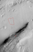
Member Group: Members Posts: 306 Joined: 4-October 14 Member No.: 7273 |
Double-post just to add another attachment, which has Curiosity's current location as a red X and an outline of the RMI mosaic footprint.
Attached thumbnail(s)
|
|
|
|
|
|
|
Mar 7 2018, 01:31 AM
Post
#69
|
||
|
Senior Member Group: Members Posts: 2429 Joined: 30-January 13 From: Penang, Malaysia. Member No.: 6853 |
Fantastic work on the RMI mosaics guys
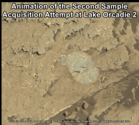
Simple animated GIF of the second sample acquisition attempt at Lake Orcadie 2 (1.5 second blink rate) Source frames (sol 1980 & sol 1983) Margins added to roughly align the frames. Now time to seek 'Softer Pastures'
|
|
|
|
|
|
|
Mar 7 2018, 01:52 AM
Post
#70
|
|
|
Solar System Cartographer Group: Members Posts: 10166 Joined: 5-April 05 From: Canada Member No.: 227 |
Wow, Justin - fantastic results!
Phil -------------------- ... because the Solar System ain't gonna map itself.
Also to be found posting similar content on https://mastodon.social/@PhilStooke Maps for download (free PD: https://upload.wikimedia.org/wikipedia/comm...Cartography.pdf NOTE: everything created by me which I post on UMSF is considered to be in the public domain (NOT CC, public domain) |
|
|
|
|
Mar 7 2018, 11:17 AM
Post
#71
|
||
|
Senior Member Group: Members Posts: 2429 Joined: 30-January 13 From: Penang, Malaysia. Member No.: 6853 |
Here is my version of the sol 1984 long-distance RMI mosaic that the sol 1984 mission update refers to as 'a portion of the clay unit that represents part of Curiosity's future agenda'. I have sharpened the images a little before assembling in ICE. There was also another RMI sequence of the PV fan, but I think I best leave that mosaic to Justin and the other experts
|
|
|
|
|
|
|
Mar 8 2018, 10:40 AM
Post
#72
|
||
|
Senior Member Group: Members Posts: 2833 Joined: 22-April 05 From: Ridderkerk, Netherlands Member No.: 353 |
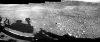
The Navcam L panoramic view on Sol 1985.
Jan van Driel
|
|
|
|
|
|
|
Mar 8 2018, 11:32 AM
Post
#73
|
|
|
Senior Member Group: Members Posts: 1619 Joined: 12-February 06 From: Bergerac - FR Member No.: 678 |
Sol 1985 Navcam panoramic
-------------------- |
|
|
|
|
Mar 8 2018, 08:23 PM
Post
#74
|
||
|
Solar System Cartographer Group: Members Posts: 10166 Joined: 5-April 05 From: Canada Member No.: 227 |
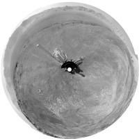
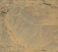
Thanks for that nice panorama! Here is a circular projection of it. You can see the tracks leading up from the previous outcrop site to the current location, almost in a straight line.
Phil
-------------------- ... because the Solar System ain't gonna map itself.
Also to be found posting similar content on https://mastodon.social/@PhilStooke Maps for download (free PD: https://upload.wikimedia.org/wikipedia/comm...Cartography.pdf NOTE: everything created by me which I post on UMSF is considered to be in the public domain (NOT CC, public domain) |
|
|
|
|
|
|
Mar 8 2018, 11:15 PM
Post
#75
|
||
|
Senior Member Group: Members Posts: 2429 Joined: 30-January 13 From: Penang, Malaysia. Member No.: 6853 |
Nice work on the 360's and the circular projection
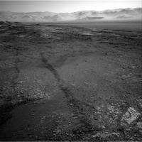
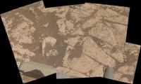
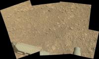
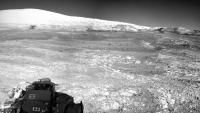
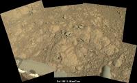
Here's the Sol 1985 L-MastCam Workspace mosaic. Unprocessed, only assembled in MS ICE. No contact science planned on this gravelly patch of ground, so another drive is planned for 1986 heading towards the Northeast
|
|
|
|
|
|
|
Mar 9 2018, 11:23 AM
Post
#76
|
|
|
Senior Member Group: Members Posts: 1619 Joined: 12-February 06 From: Bergerac - FR Member No.: 678 |
Sol 1986 Navcam pan is already here
 And thank you Paul ^^ -------------------- |
|
|
|
|
Mar 9 2018, 12:02 PM
Post
#77
|
|
 Senior Member Group: Members Posts: 1088 Joined: 19-February 05 From: Close to Meudon Observatory in France Member No.: 172 |
QUOTE (Ant103 @ Mar 9 2018, 12:23 PM) Sol 1986 Navcam pan is already here And thank you Paul ^^ Thanks very much Ant103
|
|
|
|
|
Mar 9 2018, 06:31 PM
Post
#78
|
||
|
Solar System Cartographer Group: Members Posts: 10166 Joined: 5-April 05 From: Canada Member No.: 227 |
Yes indeed, thanks! Here is a circular projection of it which I used to update the map.
Phil
-------------------- ... because the Solar System ain't gonna map itself.
Also to be found posting similar content on https://mastodon.social/@PhilStooke Maps for download (free PD: https://upload.wikimedia.org/wikipedia/comm...Cartography.pdf NOTE: everything created by me which I post on UMSF is considered to be in the public domain (NOT CC, public domain) |
|
|
|
|
|
|
Mar 9 2018, 10:04 PM
Post
#79
|
|
|
Solar System Cartographer Group: Members Posts: 10166 Joined: 5-April 05 From: Canada Member No.: 227 |
A little discrepancy in names... can anyone throw any light on this situation?
Due west of our current position there is a distinctive crater at the foot of the wall of Gale crater. It seems to have been given two names: Slangpos: https://www.hou.usra.edu/meetings/lpsc2017/pdf/2995.pdf Slagnos: https://www.jpl.nasa.gov/spaceimages/details.php?id=PIA22208 Slangpos looks like the correct name to me (matching the Namibian naming scheme used during the period when the ChemCam RMI mosaic was made, see link). So is Slagnos a mistake, or a separate name? Please let me know if you have any insight into this. Phil -------------------- ... because the Solar System ain't gonna map itself.
Also to be found posting similar content on https://mastodon.social/@PhilStooke Maps for download (free PD: https://upload.wikimedia.org/wikipedia/comm...Cartography.pdf NOTE: everything created by me which I post on UMSF is considered to be in the public domain (NOT CC, public domain) |
|
|
|
|
Mar 9 2018, 11:30 PM
Post
#80
|
|
|
Administrator Group: Admin Posts: 5172 Joined: 4-August 05 From: Pasadena, CA, USA, Earth Member No.: 454 |
Fred Calef says its Slangpos crater.
-------------------- My website - My Patreon - @elakdawalla on Twitter - Please support unmannedspaceflight.com by donating here.
|
|
|
|
|
Mar 9 2018, 11:39 PM
Post
#81
|
|
|
Solar System Cartographer Group: Members Posts: 10166 Joined: 5-April 05 From: Canada Member No.: 227 |
Thanks, Emily and Fred.
Phil -------------------- ... because the Solar System ain't gonna map itself.
Also to be found posting similar content on https://mastodon.social/@PhilStooke Maps for download (free PD: https://upload.wikimedia.org/wikipedia/comm...Cartography.pdf NOTE: everything created by me which I post on UMSF is considered to be in the public domain (NOT CC, public domain) |
|
|
|
|
Mar 10 2018, 09:06 AM
Post
#82
|
|
|
Senior Member Group: Members Posts: 3516 Joined: 4-November 05 From: North Wales Member No.: 542 |
QUOTE (Phil Stooke @ Mar 9 2018, 10:04 PM) A little discrepancy in names... https://www.jpl.nasa.gov/spaceimages/details.php?id=PIA22208 A very nice location map (despite the Slangpos error) which I had not seen until you posted it, thanks. One thing: for me the nested link to the 22210 panorama does not work, so for anyone like myself following here and wishing to compare the two here's one that should - https://www.google.co.uk/url?sa=t&rct=j...4pSt51gGJFAjI4n
|
|
|
|
|
Mar 10 2018, 06:56 PM
Post
#83
|
|
|
Member Group: Members Posts: 201 Joined: 16-December 13 Member No.: 7067 |
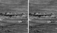
 animation of drilling on sol 1982 |
|
|
|
|
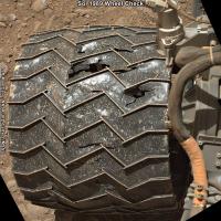
Mar 12 2018, 01:59 AM
Post
#84
|
||
|
Senior Member Group: Members Posts: 2429 Joined: 30-January 13 From: Penang, Malaysia. Member No.: 6853 |
Nice animation
Another drive during Sol 1989. No drive data yet but they performed a series of wheel checks at the onset of the drive, then drove for around 1 hour. I've roughly assembled the available L-NavCams in MS ICE. Edit: Looks like the rover did a turn in place after this small set was acquired.
|
|
|
|
|
|
|
Mar 14 2018, 02:59 AM
Post
#85
|
||
|
Senior Member Group: Members Posts: 2429 Joined: 30-January 13 From: Penang, Malaysia. Member No.: 6853 |
L-NavCam mid drive imaging on Sol 1991. Roughly assembled in MS ICE
EDIT: Midnight Planets reports the drive as ~15.0m ENE
|
|
|
|
|
|
|
Mar 14 2018, 03:26 PM
Post
#86
|
||
|
Senior Member Group: Members Posts: 2429 Joined: 30-January 13 From: Penang, Malaysia. Member No.: 6853 |
A small taste of what is to come in the 360 when all the images come down, It's going to be an interesting traverse across the trough and onto the rounded buttes and mesas of the sulfate unit
Cropped from 4 L-NavCam frames |
|
|
|
|
|
|
Mar 14 2018, 05:25 PM
Post
#87
|
|
|
Founder Group: Chairman Posts: 14432 Joined: 8-February 04 Member No.: 1 |
Sadly I couldn't get enough bits in the plan to finish that upper tier - I only had two frames to spend, and needed three
|
|
|
|
|
Mar 14 2018, 08:56 PM
Post
#88
|
|
|
Member Group: Members Posts: 810 Joined: 3-June 04 From: Brittany, France Member No.: 79 |
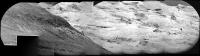
A postcard from Mars, sol 1981. I love how the late afternoon light enhances the relief of the hills...

-------------------- |
|
|
|
|
Mar 15 2018, 12:51 AM
Post
#89
|
||
|
Senior Member Group: Members Posts: 2429 Joined: 30-January 13 From: Penang, Malaysia. Member No.: 6853 |
QUOTE (neo56 @ Mar 15 2018, 04:56 AM) A postcard from Mars, sol 1981. I love how the late afternoon light enhances the relief of the hills... A de-bayered Gem, thanks Thomas Here's a simple mosaic using L-MastCam frames from the recent wheel checks on Sol 1989
|
|
|
|
|
|
|
Mar 15 2018, 12:51 PM
Post
#90
|
|||
|
Senior Member Group: Members Posts: 2429 Joined: 30-January 13 From: Penang, Malaysia. Member No.: 6853 |
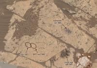
Numerous small light-toned structures (crystals?) in this sol 1991 pre-drive target? I think it could be called 'Seaforth Head' as it was the only MALI target mission update
R-MastCam link
MAHLI link
|
||
|
|
|
||
|
Mar 15 2018, 03:55 PM
Post
#91
|
||
|
Senior Member Group: Members Posts: 2429 Joined: 30-January 13 From: Penang, Malaysia. Member No.: 6853 |
Sol 1991 arm workspace (L-MastCam. MS ICE raw
|
|
|
|
|
|
|
Mar 16 2018, 10:40 AM
Post
#92
|
||
|
Senior Member Group: Members Posts: 2833 Joined: 22-April 05 From: Ridderkerk, Netherlands Member No.: 353 |
The Navcam L view on Sol 1991.
Jan van Driel
|
|
|
|
|
|
|
Mar 16 2018, 11:44 AM
Post
#93
|
|
|
Senior Member Group: Members Posts: 1619 Joined: 12-February 06 From: Bergerac - FR Member No.: 678 |
My take on this Sol 1991 :
-------------------- |
|
|
|
|
Mar 17 2018, 08:38 PM
Post
#94
|
|
|
Member Group: Members Posts: 810 Joined: 3-June 04 From: Brittany, France Member No.: 79 |
A mosaic of three MC100 pictures taken on sol 1987 showing nice details on the foothills and yardangs.
-------------------- |
|
|
|
|
Mar 18 2018, 01:50 AM
Post
#95
|
||
|
Senior Member Group: Members Posts: 2429 Joined: 30-January 13 From: Penang, Malaysia. Member No.: 6853 |
Very nice processing from Jan, Damia and Thomas
Sadly there's some data drop out on this telephoto RMI frames from this mosaic, so this was the best I could do with MS ICE and the available images, hopefully they will be able to command the rover to resend the affected frames? If not I am sure there will be a better version posted soon, maybe even a colour composite (hint) Looks like this sol 1994 mosaic was targeting the stratigraphy of the edge of a Mesa from the Sulfate unit and a section of the more distant Light Toned Yardang Unit' (LTYu), the mission plan called for two RMI's of the Yardang unit, so hopefully this one could be extended or we have another one to look forward to.
Raw images: link EDIT: A few images have been resent, leaving just one with drop out, but looks like only one has been enhanced so far, fingers crossed for the remaining image and all to be enhanced |
|
|
|
|
|
|
Mar 18 2018, 01:55 AM
Post
#96
|
|||
|
Solar System Cartographer Group: Members Posts: 10166 Joined: 5-April 05 From: Canada Member No.: 227 |
RMI took a super-resolution sequence in the peace Valley fan on sol 1993. Here's a quick look at it. The images were registered, enlarged 3x, sharpened and merged. A comparison between part of it and one of the original images (the last one), enlarged 3x, is included. Of course, the real PDS data will give better results.
Phil PS OK, RMI persons, how about doing this for the landing site, maybe targeted to include the bit of the backshell which Doug thought he could see...
-------------------- ... because the Solar System ain't gonna map itself.
Also to be found posting similar content on https://mastodon.social/@PhilStooke Maps for download (free PD: https://upload.wikimedia.org/wikipedia/comm...Cartography.pdf NOTE: everything created by me which I post on UMSF is considered to be in the public domain (NOT CC, public domain) |
||
|
|
|
||
|
Mar 18 2018, 02:23 AM
Post
#97
|
||
|
Solar System Cartographer Group: Members Posts: 10166 Joined: 5-April 05 From: Canada Member No.: 227 |
... and Jan's 1991 panorama in circular form.
Phil
-------------------- ... because the Solar System ain't gonna map itself.
Also to be found posting similar content on https://mastodon.social/@PhilStooke Maps for download (free PD: https://upload.wikimedia.org/wikipedia/comm...Cartography.pdf NOTE: everything created by me which I post on UMSF is considered to be in the public domain (NOT CC, public domain) |
|
|
|
|
|
|
Mar 18 2018, 06:37 PM
Post
#98
|
|
|
Senior Member Group: Members Posts: 4247 Joined: 17-January 05 Member No.: 152 |
That shows really nicely how we're perched on the ridge above some pretty steep cliffs above the plain in the north, Phil.
|
|
|
|
|
Mar 19 2018, 04:31 AM
Post
#99
|
||
|
Senior Member Group: Members Posts: 2429 Joined: 30-January 13 From: Penang, Malaysia. Member No.: 6853 |
Sol 1993 arm workspace (L-MastCam. MS ICE raw)
|
|
|
|
|
|
|
Mar 19 2018, 10:20 AM
Post
#100
|
|
|
Senior Member Group: Members Posts: 2429 Joined: 30-January 13 From: Penang, Malaysia. Member No.: 6853 |
Another drive, looks to be Northeast (again) probably towards that CRISM target on one of Phil's wide area maps?
ICE is not behaving with the available images, maybe I'll have more success when more come down Link |
|
|
|
 |

|
Lo-Fi Version | Time is now: 23rd May 2024 - 09:39 AM |
|
RULES AND GUIDELINES Please read the Forum Rules and Guidelines before posting. IMAGE COPYRIGHT |
OPINIONS AND MODERATION Opinions expressed on UnmannedSpaceflight.com are those of the individual posters and do not necessarily reflect the opinions of UnmannedSpaceflight.com or The Planetary Society. The all-volunteer UnmannedSpaceflight.com moderation team is wholly independent of The Planetary Society. The Planetary Society has no influence over decisions made by the UnmannedSpaceflight.com moderators. |
SUPPORT THE FORUM Unmannedspaceflight.com is funded by the Planetary Society. Please consider supporting our work and many other projects by donating to the Society or becoming a member. |
|