Distant Vistas 2 - The view from Cape Tribulation |

Distant Vistas 2 - The view from Cape Tribulation |
 Nov 17 2014, 08:58 PM Nov 17 2014, 08:58 PM
Post
#1
|
|
|
Senior Member  Group: Members Posts: 3516 Joined: 4-November 05 From: North Wales Member No.: 542 |
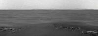
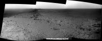
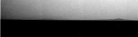
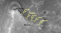
The latest pancams show some interesting bumps on the far horizon as well as long 'swells' on the plain that might respond well to 'phil-o-vision'. Time for the 'Distant Vistas' team to resume work? I'm not going to attempt the first identifications as I have little idea what azimuths we're looking at. Also I don't know what visibility to expect with the current dust levels.
|
 |
 
|
 |
|
Nov 17 2014, 10:00 PM
Post
#2
|
||
|
Solar System Cartographer Group: Members Posts: 10191 Joined: 5-April 05 From: Canada Member No.: 227 |
By jingo - you're right... here's a stretched look at the western horizon. IDs will have to wait a bit.
Phil
-------------------- ... because the Solar System ain't gonna map itself.
Also to be found posting similar content on https://mastodon.social/@PhilStooke Maps for download (free PD: https://upload.wikimedia.org/wikipedia/comm...Cartography.pdf NOTE: everything created by me which I post on UMSF is considered to be in the public domain (NOT CC, public domain) |
|
|
|
|
|
|
Nov 18 2014, 12:26 AM
Post
#3
|
||
 Senior Member Group: Members Posts: 1089 Joined: 19-February 05 From: Close to Meudon Observatory in France Member No.: 172 |
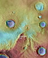
QUOTE (Phil Stooke @ Nov 17 2014, 11:00 PM)  By jingo - you're right... here's a stretched look at the western horizon. IDs will have to wait a bit. Phil Thanks Phil and Ngunn : maybe we will be able to see also the distant rim of Bopolu crater on the western horizon when we reach the summit... (see Bopolu Crater herebelow : a Sol 2195 image) 
|
|
|
|
|
|
|
Nov 19 2014, 12:04 AM
Post
#4
|
||
 Senior Member Group: Moderator Posts: 2262 Joined: 9-February 04 From: Melbourne - Oz Member No.: 16 |
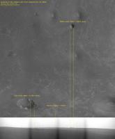
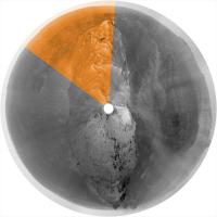
Well I think it's likely that the central hazy feature is Bopolu.
Dusting off my 'inverse polar' analysis with my id's of a couple of more nearby craters.
-------------------- |
|
|
|
|
|
|
Nov 19 2014, 12:55 AM
Post
#5
|
|
|
Solar System Cartographer Group: Members Posts: 10191 Joined: 5-April 05 From: Canada Member No.: 227 |
Good! And in addition, in the right foreground is a broad shallow depression visible in both pan and map.
Phil -------------------- ... because the Solar System ain't gonna map itself.
Also to be found posting similar content on https://mastodon.social/@PhilStooke Maps for download (free PD: https://upload.wikimedia.org/wikipedia/comm...Cartography.pdf NOTE: everything created by me which I post on UMSF is considered to be in the public domain (NOT CC, public domain) |
|
|
|
|
Nov 19 2014, 12:18 PM
Post
#6
|
||
|
Senior Member Group: Members Posts: 1089 Joined: 19-February 05 From: Close to Meudon Observatory in France Member No.: 172 |
QUOTE (Ant103 @ Nov 19 2014, 12:25 PM) Hi I don't know if it's a come back, but I feel the envy to do some stitchings these days (maybe it's because the summit is near). So, Sol 3846 Navcam panoramic :Thanks a lot, Damia ! How nice ! ...and, Phil, jamescanvin and ngunn : -in theory- we would be able to discern from the very summit of Cape Tribulation a faint line lying on the north-western horizon showing Victoria Crater ! Herebelow as a reminder, Cape Tribulation as seen from the rim of Victoria Crater on Sol 986. Enjoy
|
|
|
|
|
|
|
Nov 19 2014, 03:08 PM
Post
#7
|
|
|
Junior Member Group: Members Posts: 32 Joined: 3-May 04 From: mes pieds à Paris, mon coeur dans les Pyrénées, mon esprit dans l'Espace Member No.: 72 |
QUOTE (vikingmars @ Nov 19 2014, 01:18 PM) Thanks a lot, Damia ! How nice ! ...and, Phil, jamescanvin and ngunn : -in theory- we would be able to discern from the very summit of Cape Tribulation a faint line lying on the north-western horizon showing Victoria Crater ! Herebelow as a reminder, Cape Tribulation as seen from the rim of Victoria Crater on Sol 986. Enjoy Well done, Olivier ! |
|
|
|
|
Nov 19 2014, 04:09 PM
Post
#8
|
|
|
Senior Member Group: Moderator Posts: 2262 Joined: 9-February 04 From: Melbourne - Oz Member No.: 16 |
QUOTE (vikingmars @ Nov 19 2014, 12:18 PM) ...and, Phil, jamescanvin and ngunn : -in theory- we would be able to discern from the very summit of Cape Tribulation a faint line lying on the north-western horizon showing Victoria Crater ! Indeed. And a few sols ago Oppy took some images looking that way! I have been anxiously waiting for them to come down... 
-------------------- |
|
|
|
|
Nov 19 2014, 04:45 PM
Post
#9
|
|
 Senior Member Group: Members Posts: 4252 Joined: 17-January 05 Member No.: 152 |
QUOTE (vikingmars @ Nov 19 2014, 01:18 PM) Cape Tribulation as seen from the rim of Victoria Crater on Sol 986. Sorry, Viking, I have to correct you! I know it's been a long time since Victoria, but from there we only saw what we called the "Twin Peaks" on the north rim of Endeavour, and what we called "Cook", the highest peak on the east rim (the one with the prominent crater below the peak). The peak you show in your attachment is "Cook". Check out James's identification from Victoria in this post. The first clear sighting of Tribulation I know of was on sol 1820 in this pancam frame. Again see James's identification in this post. That was near Cook Islands/Resolution, about 2 km south of Victoria. It's still possible that Tribulation was technically visible from Victoria, but peeked only a couple of pixels above the horizon so wasn't discernable in pancam. In that case we would see the rim of Victoria from the summit of Tribulation. So it's definitely worth looking when we get there! |
|
|
|
|
Nov 19 2014, 06:19 PM
Post
#10
|
|
|
Senior Member Group: Members Posts: 2922 Joined: 14-February 06 From: Very close to the Pyrénées Mountains (France) Member No.: 682 |
I guess you all remember how we used to see Victoria coming from Endurance? Yes, the BEACON!
Any chance we could see a cliff of Victoria acting as a beacon...if the MER team is ever to command Oppy to take a picture by early morning? -------------------- |
|
|
|
|
Nov 19 2014, 06:23 PM
Post
#11
|
||
|
Member Group: Members Posts: 111 Joined: 14-March 05 From: Vastitas Borealis Member No.: 193 |
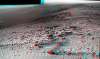
Vikingmars. fredk, climber: I have something to add here, an enlarged (2x) and stretched (2x) crop of this sol 950 pancam, or rather the equivalent anaglyph, showing exactly those few pixels of Cape Tribulation and some peaks to the south of it.
I think this was the highest location where Cape Tribulation ever was visible at Victoria, and the image represents something like the topmost 10-15 m of the Endeavour rim peaks seen from ~18 km away. Conversely, the high craggy wall of Cape St. Mary facing us now could be just discernible from the summit as a mere sliver of the whole with 1-2 pix of vertical extent, unless the horizon comes between even worse than I imagine and/or the weather renders visibility too poor. (Edited for style and to correct minor errors.)
Attached thumbnail(s)
|
|
|
|
|
|
|
Nov 19 2014, 08:38 PM
Post
#12
|
||
|
Senior Member Group: Members Posts: 4252 Joined: 17-January 05 Member No.: 152 |
As amazing as it sounds, I'm pretty sure that that bump just peeking above the horizon in marswiggle's post is a piece of the rim of Iazu, rather than Tribulation. The sky was extremely clear at that time. And Iazu should actually look a bit higher than Tribulation from Victoria.
Compare the view from 1820 (upper part of my new pic below, from James's post), when we got our first clear view of Tribulation with the bump in marswiggle's post (lower part):
In the upper part, Tribulation's on the left and Iazu on the right. It's pretty clear that the shape of marswiggle's bump (small bit on left, larger part on right) doesn't match the shape of Tribulation (two bits, taller one on right). But marswiggle's bump matches the shape of the Iazu piece pretty well. A fainter piece of Iazu farther to the right might be visible as well. Still, we were definitely close to seeing Tribulation, and with another metre in rover height may just see Victoria from the summit... |
|
|
|
|
|
|
Nov 19 2014, 09:31 PM
Post
#13
|
|
|
Member Group: Members Posts: 111 Joined: 14-March 05 From: Vastitas Borealis Member No.: 193 |
Wow, fredk, never thought of that possibility. Another consideration, the azimuths from sol 950 location to the highest peaks of Endeavour / Iazu (using Google Mars) pretty much converge to each other, could they even be blended into one and the same blurred shape here? Admittedly, the shape in my previous post is largely similar to the Iazu outline, which does not exclude the possibility that Tribulation is 'shadowed' by the more distant rim.
|
|
|
|
|
Nov 19 2014, 10:43 PM
Post
#14
|
|||
|
Senior Member Group: Members Posts: 4252 Joined: 17-January 05 Member No.: 152 |
Yikes, you may be right. Here's the Duck Bay - Iazu line of sight, showing it does come very close to Tribulation:
Something always looked odd about marswiggle's bump. The part circled in black looks less hazy than the rest (presumably Iazu). Maybe that's the highest bit of Tribulation, which was much closer and so should look less hazy:
This could be better checked using the PDS and combining the various frames, if someone has time... But if this is right, it would mean we'll definitely have a line of sight to Victoria from the summit! |
||
|
|
|
||
|
Nov 20 2014, 08:43 AM
Post
#15
|
|
|
Senior Member Group: Moderator Posts: 2262 Joined: 9-February 04 From: Melbourne - Oz Member No.: 16 |
QUOTE (fredk @ Nov 19 2014, 10:43 PM) Something always looked odd about marswiggle's bump. The part circled in black looks less hazy than the rest (presumably Iazu). Maybe that's the highest bit of Tribulation, which was much closer and so should look less hazy: That is pretty tantalizing - someone definitely needs to dig out and process the PDS data.
-------------------- |
|
|
|
|
Dec 17 2014, 12:18 AM
Post
#16
|
||
|
Senior Member Group: Members Posts: 1074 Joined: 21-September 07 From: Québec, Canada Member No.: 3908 |
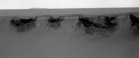
I don't know if this has been noticed before. In the attached (enhanced) pancam image taken on sol 3873, there is a very faint hill. I tried to bring it out somewhat (noise removed, fiddled with curves in Photoshop). The direction is over the plains, to the right of Cape Tribulation. Could it be Bopolu crater? On the other hand, it doesn't seem wide enough for that.
|
|
|
|
|
|
|
Dec 17 2014, 01:30 AM
Post
#17
|
|||
|
Senior Member Group: Members Posts: 4252 Joined: 17-January 05 Member No.: 152 |
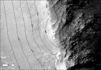
I've been eyeing that feature for several sols - notice how the view has improved since 3863: we have climbed substantially since then and can see much more of the feature:
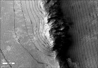
http://mars.nasa.gov/mer/gallery/all/1/p/3...L1P2426R1M1.JPG This is too far to the south to be Bopolu and has the wrong shape - here's an old view of Bopolu:
I've been meaning to check some azimuths but haven't had time. My too-many-years-staring-at-Mars-images intuition says it's the crater rim I've circled here:
But again, I'd need to do some measurements to be sure. Once we're closer to the summit we should see Iazu again and that'll fix things better. But if this is right, this is the farthest feature we've seen from Oppy - it's farther than Bopolu and the Miyamoto rim segment ("mule ears" we called it those years ago). |
||
|
|
|
||
|
Dec 17 2014, 11:05 AM
Post
#18
|
|
|
Senior Member Group: Members Posts: 3516 Joined: 4-November 05 From: North Wales Member No.: 542 |
I've been watching that too and thinking it might be Miyamoto. I'd expect the 'mule ears' to be lined up to appear as one from where we are now. But I have no handle on the azimuths so that was a wild guess. It would be exciting to be seeing an even more distant feature but I'd find that surprising given the curvature of the planet. Might be worth checking the theoretical visibility with Google Earth Mars
|
|
|
|
|
Dec 17 2014, 08:49 PM
Post
#19
|
|
|
Senior Member Group: Members Posts: 3516 Joined: 4-November 05 From: North Wales Member No.: 542 |
A crude estimate from the pancams puts the main peak 40 to 45-ish degrees to the right of Tribulation summit which I think is about right for the combined 'Mule Ears'. Also I think there is a long low distant horizon feature well to the left in that same image. This could be the nearer hills we were originally looking for in that general direction when the 'Mule Ears' popped up instead.
|
|
|
|
|
Dec 17 2014, 09:07 PM
Post
#20
|
||
|
Senior Member Group: Moderator Posts: 2262 Joined: 9-February 04 From: Melbourne - Oz Member No.: 16 |
Based on the Azimuth and size I think it is probably this:
-------------------- |
|
|
|
|
|
|
Dec 17 2014, 09:38 PM
Post
#21
|
|
|
Senior Member Group: Members Posts: 3516 Joined: 4-November 05 From: North Wales Member No.: 542 |
Do you mean that is the main peak showing in the image charborob posted? That's the feature I thought might be the lower hills I referred to in my post just before yours. The trouble with those hills being the main peak visible in charborob's image is that if they were that big we should have seen them before when we first saw the 'Mule Ears'.
|
|
|
|
|
Dec 17 2014, 10:20 PM
Post
#22
|
|
|
Senior Member Group: Moderator Posts: 2262 Joined: 9-February 04 From: Melbourne - Oz Member No.: 16 |
Yes I think that is the horizon feature charborob posted. Back in 2010 when we were looking at the 'Mule Ears' we didn't have a great view on that azimuth. It sits in a bit of a dip and we had a closeish horizon in that direction back then. Now it looks to be much more favourable. I don't think the azimuth is right to be the 'Mule Ears', if we got the ID right back in 2010 they should be about half a Pancam frame further to the right.
-------------------- |
|
|
|
|
Dec 17 2014, 10:36 PM
Post
#23
|
|
|
Senior Member Group: Members Posts: 3516 Joined: 4-November 05 From: North Wales Member No.: 542 |
OK, thanks. I'm glad you're in on the hunt. If you're right we should have a great view of the Miyamoto rim just a bit to the right of what we see now. It's not much further away than than this feature. Maybe there is already something visible at the extreme right of the image. I've been scutinising that but everything darkens there so it's difficult to say. I hope you will have time to provide us with one of your wonderful reverse polar horizon analyses when we reach the summit.
|
|
|
|
|
Dec 17 2014, 10:56 PM
Post
#24
|
|
|
Senior Member Group: Moderator Posts: 2262 Joined: 9-February 04 From: Melbourne - Oz Member No.: 16 |
Yeah really looking forward to the summit pan, that should nail things down. I wonder how good the view will be though. I don't think the visibility is all that great, else I we should be able to see more of Miyamoto right now.
-------------------- |
|
|
|
|
Jan 7 2015, 11:31 AM
Post
#25
|
|
|
Senior Member Group: Members Posts: 3516 Joined: 4-November 05 From: North Wales Member No.: 542 |
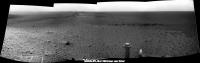
Clear view forward: http://qt.exploratorium.edu/mars/opportuni...DGP1870L0M1.JPG
|
|
|
|
|
Jan 7 2015, 02:46 PM
Post
#26
|
||
|
Senior Member Group: Members Posts: 1089 Joined: 19-February 05 From: Close to Meudon Observatory in France Member No.: 172 |
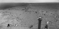
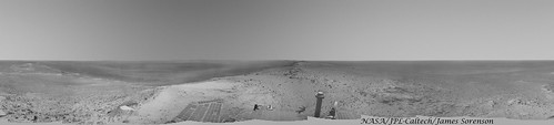
YES ! Incredible ! We are now standing at the very summit of Cape Tribulation !
Here is the view towards the south : we are indeed standing at the topmost point. I could not imagine such a feat in 2004 for the Opportunity mission in my wildest dreams... CONGRATULATIONS to the MER team ! 
|
|
|
|
|
|
|
Jan 7 2015, 03:25 PM
Post
#27
|
|
 Member Group: Members Posts: 691 Joined: 21-December 07 From: Clatskanie, Oregon Member No.: 3988 |
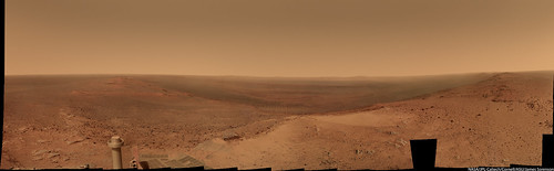
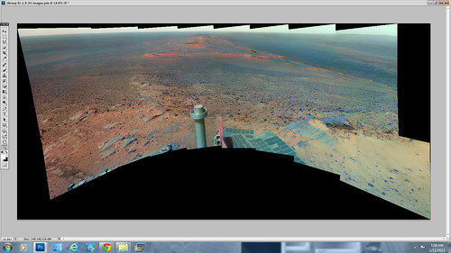
My take on this breathtaking and monumental vista. A truly wonderful achievement for the whole MER team.
 Polar:  1920x1080 Desktop Background 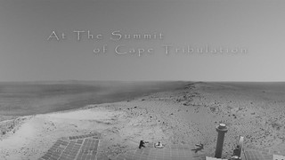
|
|
|
|
|
Jan 7 2015, 04:09 PM
Post
#28
|
||
|
Solar System Cartographer Group: Members Posts: 10191 Joined: 5-April 05 From: Canada Member No.: 227 |
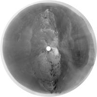
Stunning!
This is James's panorama in circular format. Phil
-------------------- ... because the Solar System ain't gonna map itself.
Also to be found posting similar content on https://mastodon.social/@PhilStooke Maps for download (free PD: https://upload.wikimedia.org/wikipedia/comm...Cartography.pdf NOTE: everything created by me which I post on UMSF is considered to be in the public domain (NOT CC, public domain) |
|
|
|
|
|
|
Jan 7 2015, 04:52 PM
Post
#29
|
|
 Interplanetary Dumpster Diver Group: Admin Posts: 4404 Joined: 17-February 04 From: Powell, TN Member No.: 33 |
Wow oh wow! I never thought I'd see Oppy become a mountain climber!
-------------------- |
|
|
|
|
Jan 7 2015, 04:59 PM
Post
#30
|
|
|
Founder Group: Chairman Posts: 14433 Joined: 8-February 04 Member No.: 1 |
And for the past month or so - without the use of flash memory.
Extraordinary. |
|
|
|
|
Jan 7 2015, 05:17 PM
Post
#31
|
|
|
Senior Member Group: Members Posts: 2090 Joined: 13-February 10 From: Ontario Member No.: 5221 |
Congrats to the team! 11 years after landing; well deserved.
Presumably there will be a short stay to make a big panorama? |
|
|
|
|
Jan 7 2015, 06:12 PM
Post
#32
|
|
|
Senior Member Group: Members Posts: 2922 Joined: 14-February 06 From: Very close to the Pyrénées Mountains (France) Member No.: 682 |
Hi climber!(From climber)
-------------------- |
|
|
|
|
Jan 7 2015, 06:34 PM
Post
#33
|
||
|
Senior Member Group: Members Posts: 4252 Joined: 17-January 05 Member No.: 152 |
QUOTE (Explorer1 @ Jan 7 2015, 06:17 PM) Presumably there will be a short stay to make a big panorama? That's right, according to the new PS update:QUOTE The plans for Opportunity in 2015 remain the same: drive to the summit of Cape Tribulation, take what will probably be another breathtaking panorama from the vista point, and then rove on to Spirit of St. Louis Crater, and just beyond, Marathon Valley. Huge congratulations to the team. What a way to celebrate 11 years! With the opening up of the view to the south, we now have our first good look at Iazu in a long time:
|
|
|
|
|
|
|
Jan 7 2015, 07:23 PM
Post
#34
|
|
|
Junior Member Group: Members Posts: 32 Joined: 3-May 04 From: mes pieds à Paris, mon coeur dans les Pyrénées, mon esprit dans l'Espace Member No.: 72 |
QUOTE (climber @ Jan 7 2015, 07:12 PM) Hi climber!(From climber) Hi Climber (from Paris) ! |
|
|
|
|
Jan 7 2015, 09:04 PM
Post
#35
|
|
|
Senior Member Group: Members Posts: 1089 Joined: 19-February 05 From: Close to Meudon Observatory in France Member No.: 172 |
QUOTE (climber @ Jan 7 2015, 07:12 PM) Hi climber!(From climber) Hi Climber (from Meudon) ! |
|
|
|
|
Jan 7 2015, 10:15 PM
Post
#36
|
||
 Senior Member Group: Admin Posts: 3108 Joined: 21-December 05 From: Canberra, Australia Member No.: 615 |
If this isn't today's newspaper headline somewhere, then I'll be disappointed

Nod to James for his summit image. |
|
|
|
|
|
|
Jan 7 2015, 11:37 PM
Post
#37
|
|
|
Senior Member Group: Members Posts: 4252 Joined: 17-January 05 Member No.: 152 |
Ha! But maybe considering the translation from 11 human years to "rover years", and Oppy's condition, the story would read:
115 year old lady, deaf and suffering from arthritis and dementia, reaches summit walking backwards. |
|
|
|
|
Jan 8 2015, 12:03 AM
Post
#38
|
|
|
Senior Member Group: Members Posts: 2090 Joined: 13-February 10 From: Ontario Member No.: 5221 |
Deaf how? The antennas are working just fine! Maybe the old girls' senses of smell and taste have declined (her spectrometers), but those eyes are as sharp as ever...
Sense of touch too is fine too; the RAT drill is still usable, right? |
|
|
|
|
Jan 8 2015, 02:11 AM
Post
#39
|
|
|
Senior Member Group: Members Posts: 4252 Joined: 17-January 05 Member No.: 152 |
I guess the analogy strains when pushed a bit too far. But the important point is that it's absolutely incredible that the fiesty old "lady" has made it this far!
|
|
|
|
|
Jan 8 2015, 09:35 AM
Post
#40
|
|
 Member Group: Members Posts: 214 Joined: 30-December 05 Member No.: 628 |
Go, Granny, go!
|
|
|
|
|
Jan 8 2015, 10:58 PM
Post
#41
|
|
|
Senior Member Group: Members Posts: 1045 Joined: 17-February 09 Member No.: 4605 |
QUOTE (fredk @ Jan 7 2015, 07:34 PM) That's right, according to the new PS update: I have to tip my hat to A.J.S Rayl. Her update/summary is, as always, outstanding. The snippets on Pinnacle Island were particularly interesting, correlated to the identification of other oxygenated material in fractures, with sulphur also evident. I believe that we could assume a dearth of atmospheric oxygen combined with the high probability that alteration took place underground and has subsequently been exposed by erosion. A strong oxidant (hydrogen peroxide) can result from the reaction of anoxic water with iron sulphide (pyrite). For ground water induced alteration this seems a more likely path than photolysis. |
|
|
|
|
Jan 9 2015, 12:27 AM
Post
#42
|
|
|
Member Group: Members Posts: 691 Joined: 21-December 07 From: Clatskanie, Oregon Member No.: 3988 |
The 360 color Pancam Cape Tribulation pan has begun.
http://qt.exploratorium.edu/mars/opportuni...cam/2015-01-08/ |
|
|
|
|
Jan 9 2015, 12:54 AM
Post
#43
|
|
|
Senior Member Group: Members Posts: 4252 Joined: 17-January 05 Member No.: 152 |
And it's going to be epic...
http://qt.exploratorium.edu/mars/opportuni...2M1.JPG?sol3895 |
|
|
|
|
Jan 9 2015, 01:37 AM
Post
#44
|
||
|
Member Group: Members Posts: 691 Joined: 21-December 07 From: Clatskanie, Oregon Member No.: 3988 |
To help me keep track, I'm going to be personally using Phil's projection of my Navcam summit pan to highlight what is roughly down sofar.
|
|
|
|
|
|
|
Jan 9 2015, 01:58 AM
Post
#45
|
|
|
Solar System Cartographer Group: Members Posts: 10191 Joined: 5-April 05 From: Canada Member No.: 227 |
For years now we have been wondering if Victoria crater would be visible from Endeavour. Well, it's too bad about the dusty sky, but if it's ever going to be visible, it will be in this pan. Look for a narrow strip along the horizon ridge. In images taken in the afternoon, the visible far rim (under Cape St. Mary) would be shadowed, so the crater should probably look dark if we see it at all.
Phil -------------------- ... because the Solar System ain't gonna map itself.
Also to be found posting similar content on https://mastodon.social/@PhilStooke Maps for download (free PD: https://upload.wikimedia.org/wikipedia/comm...Cartography.pdf NOTE: everything created by me which I post on UMSF is considered to be in the public domain (NOT CC, public domain) |
|
|
|
|
Jan 9 2015, 08:43 AM
Post
#46
|
|
|
Member Group: Members Posts: 691 Joined: 21-December 07 From: Clatskanie, Oregon Member No.: 3988 |
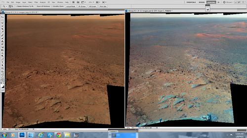
Still some work left to be done on this segment, but here is a screenshot of the pan sofar.
|
|
|
|
|
Jan 9 2015, 09:32 AM
Post
#47
|
|
|
Senior Member Group: Members Posts: 1089 Joined: 19-February 05 From: Close to Meudon Observatory in France Member No.: 172 |
QUOTE (James Sorenson @ Jan 9 2015, 09:43 AM) Still some work left to be done on this segment, but here is a screenshot of the pan sofar. WOW ! Thanks a lot James to share this excellent work of yours with us
|
|
|
|
|
Jan 9 2015, 10:09 AM
Post
#48
|
|
 Member Group: Members Posts: 813 Joined: 8-February 04 From: Arabia Terra Member No.: 12 |
Hmm, do I want the tau to improve over the next few sols so that we can see distant hills more clearly, or do I want it to stay the same so that all the pieces of the summit panorama will be taken under similar lighting conditions?
|
|
|
|
|
Jan 9 2015, 02:31 PM
Post
#49
|
|
|
Senior Member Group: Members Posts: 1089 Joined: 19-February 05 From: Close to Meudon Observatory in France Member No.: 172 |
Good question SFJCody !
On my side, I vote for the Tau improvement to see more details in the far distance, because I can play with the contrast (i.e. reduce it) in my image processing
|
|
|
|
|
Jan 9 2015, 09:34 PM
Post
#50
|
|
|
Senior Member Group: Members Posts: 1045 Joined: 17-February 09 Member No.: 4605 |
Well Spirit held the mountain climbing height record for a good while, but Opportunity has eclipsed that too.
|
|
|
|
|
Jan 9 2015, 10:00 PM
Post
#51
|
|
|
Senior Member Group: Members Posts: 3516 Joined: 4-November 05 From: North Wales Member No.: 542 |
I'm interested in knowing the elevation we are at here. It's difficult to get actual figures. Larry Crumpler's excellent contour maps have no numbers on them (or am I wrong?). We were quite high around Concepcion crater. How high are we now relative to that point? It seems to me we descended a long way before climbing this hill.
|
|
|
|
|
Jan 10 2015, 01:56 AM
Post
#52
|
|
|
Senior Member Group: Members Posts: 1045 Joined: 17-February 09 Member No.: 4605 |
Emily did a blog entry on MOLA tracks back in August 2010 and Conception is recorded as having an elevation of -1372m relative to Mars datum. Cape Tribulation has an elevation of -1380m so at the top of the mound near Conception Opportunity was a smidgeon higher than she is now. But relative to the approach to Cape Tribulation Opportunity climbed around 135 metres. Spirit climbed around 107 metres above the landing site but only some 82 metres above the base of Husband Hill.
|
|
|
|
|
Jan 10 2015, 07:30 AM
Post
#53
|
|
|
Senior Member Group: Members Posts: 3516 Joined: 4-November 05 From: North Wales Member No.: 542 |
QUOTE (serpens @ Jan 10 2015, 01:56 AM) Cape Tribulation has an elevation of -1380m so at the top of the mound near Conception Opportunity was a smidgeon higher than she is now. Thanks serpens, that's very helpful for making sense of what we see on the far horizon. I was surprised to find the opposite stated in A.J.S. Rayl's article. (I know - a bit of a nitpick as there's only a few metres involved.) |
|
|
|
|
Jan 10 2015, 12:04 PM
Post
#54
|
|
|
Member Group: Members Posts: 813 Joined: 8-February 04 From: Arabia Terra Member No.: 12 |
I imagine this is the highest elevation she'll ever drive to.
Unless of course they manage to get down to the northern rim of Iazu.  A marathon is all very well, but achieving 100X the mission success drive goal would be something else!
|
|
|
|
|
Jan 10 2015, 01:33 PM
Post
#55
|
|
|
Senior Member Group: Members Posts: 1045 Joined: 17-February 09 Member No.: 4605 |
QUOTE (ngunn @ Jan 10 2015, 07:30 AM) .....(I know - a bit of a nitpick as there's only a few metres involved.) Larry Crumpler's field report of 12 December had the summit as -1380. But his latest has it marked as -1390. As you say only a few metres, and either a typo or it is possible that in the first instance the elevation against Cape Tribulation actually referred to the elevation of the rover at that time, below the peak. |
|
|
|
|
Jan 10 2015, 03:27 PM
Post
#56
|
|
|
Senior Member Group: Members Posts: 3516 Joined: 4-November 05 From: North Wales Member No.: 542 |
If -1380 was the rover elevation, not the summit, in Crumpler's previous post then maybe the summit is at -1370, not -1390 (easy to go 10m the wrong way when counting backwards). That would make Rayl's statement correct, by a margin of 2m! It's silly really but now I've started to query it I would like to find out for sure.
|
|
|
|
|
Jan 11 2015, 10:13 AM
Post
#57
|
|
|
Member Group: Members Posts: 691 Joined: 21-December 07 From: Clatskanie, Oregon Member No.: 3988 |
Another segment, another screenshot preview. This is the false color view.
|
|
|
|
|
Jan 13 2015, 05:22 PM
Post
#58
|
|
|
Senior Member Group: Members Posts: 4252 Joined: 17-January 05 Member No.: 152 |
|
|
|
|
|
Jan 13 2015, 08:02 PM
Post
#59
|
|
|
Solar System Cartographer Group: Members Posts: 10191 Joined: 5-April 05 From: Canada Member No.: 227 |
Wowsers! Finally I'm superfluous and can go back to my real love, knitting.
Very faintly visible above the ejecta of Iazu (right of centre) is a more distant ridge. It must be part of the rim of the un-named crater south of Iazu. Phil -------------------- ... because the Solar System ain't gonna map itself.
Also to be found posting similar content on https://mastodon.social/@PhilStooke Maps for download (free PD: https://upload.wikimedia.org/wikipedia/comm...Cartography.pdf NOTE: everything created by me which I post on UMSF is considered to be in the public domain (NOT CC, public domain) |
|
|
|
|
Jan 13 2015, 10:02 PM
Post
#60
|
|
|
Senior Member Group: Members Posts: 3516 Joined: 4-November 05 From: North Wales Member No.: 542 |
Good spot Phil. (I was looking at that very same area and couldn't figure it out.) Although these images will undoubtedly contribute to the complete panorama they also look like drive direction shots so presumably someone is already planning the next move.
While we're still on the top can I reiterate an earlier question: What is the elevation of this summit relative to Mars datum? Is it -1370, -1380 or -1390 metres . . or something else? Recent blog posts by Larry Crumpler and A.J.S. Rayl seem to give conflicting information. Somebody here must know definitively. |
|
|
|
|
Jan 13 2015, 11:11 PM
Post
#61
|
|
|
Member Group: Members Posts: 866 Joined: 15-March 05 From: Santa Cruz, CA Member No.: 196 |
|
|
|
|
|
Jan 15 2015, 04:01 AM
Post
#62
|
|
|
Senior Member Group: Members Posts: 4252 Joined: 17-January 05 Member No.: 152 |
QUOTE (serpens @ Jan 10 2015, 01:56 AM) Emily did a blog entry on MOLA tracks back in August 2010 and Conception is recorded as having an elevation of -1372m relative to Mars datum. Cape Tribulation has an elevation of -1380m so at the top of the mound near Conception Opportunity was a smidgeon higher than she is now. Remember that the MOLA samples are quite sparse. Emily's post shows that there are only a few samples very close to Oppy's route. (See also this post.) So we can't be very sure what the highest elevation we reached was. Given the uncertainty about our current elevation, I think we can only say that we're within 20 m or so of our highest point. From this official DTM elevation map you can only crudely read our elevation, but you might be able to get something more quantitative from some of the other images there. Pgrindrod did some elevation maps a while back; this one gives a good overall view of how we dropped from Victoria and then climbed back up. |
|
|
|
|
Jan 15 2015, 10:00 AM
Post
#63
|
|
|
Senior Member Group: Members Posts: 3516 Joined: 4-November 05 From: North Wales Member No.: 542 |
Just to be absolutely sure I emailed Larry Crumpler and he confirmed that -1380 figure for the summit.
|
|
|
|
|
Jan 15 2015, 10:34 AM
Post
#64
|
|
|
Senior Member Group: Members Posts: 1089 Joined: 19-February 05 From: Close to Meudon Observatory in France Member No.: 172 |
Thanks a lot ngunn.
Please, tell me if I'm wrong, but I recorded that the altitude of Opportunity's landing site is -1387m. It means that with the -1380m figure we are now just sitting slightly above the landing site, knowing that we have travelled down a slope to reach Endeavour crater...
|
|
|
|
|
Jan 15 2015, 06:14 PM
Post
#65
|
|||
|
Junior Member Group: Members Posts: 59 Joined: 18-July 07 From: London, UK Member No.: 2873 |
A local contour map from the HiRISE DTM fredk linked to. Values look good to me!
And a context map too.
|
||
|
|
|
||
|
Jan 15 2015, 06:30 PM
Post
#66
|
||
|
Senior Member Group: Members Posts: 1074 Joined: 21-September 07 From: Québec, Canada Member No.: 3908 |
Here's another PanCam view of the distant hill in a somewhat South-West direction. This time with 2x Phil-o-vision:
|
|
|
|
|
|
|
Jan 15 2015, 07:39 PM
Post
#67
|
|
|
Senior Member Group: Members Posts: 3516 Joined: 4-November 05 From: North Wales Member No.: 542 |
Yes and the latest NAVCAM of your hill (dead centre here) shows another smaller but clearer feature about 15 degrees farther to the right plus a possible faint hint of the Miyamoto rim extending between the two.
http://qt.exploratorium.edu/mars/opportuni...GKP0704L0M1.JPG And thanks pgrindrod for those excellent, very readable contour maps. They're exactly what we need and I'm delighted you're still with us on this forum. |
|
|
|
|
Jan 15 2015, 11:52 PM
Post
#68
|
|
|
Senior Member Group: Members Posts: 3516 Joined: 4-November 05 From: North Wales Member No.: 542 |
A Request: Can we please have some 'mystery men' stationed along the rim southward?
|
|
|
|
|
Jan 16 2015, 09:46 AM
Post
#69
|
|
|
Senior Member Group: Members Posts: 3516 Joined: 4-November 05 From: North Wales Member No.: 542 |
Here is a great boon for distant horizon watchers.
Larry Crumpler's latest field report for 15th Jan includes a navcam panorama with an azimuth scale. The central image in the panorama is the one I linked to two posts up. This should nail the IDs of the horizon features.http://www.google.co.uk/url?sa=t&rct=j....83829542,d.d24 EDIT: Apologies for the messy link. Maybe someone can replace it with a better one? My first rough estimates for the azimuths: charborob's hill 197, possible Miyamoto rim 205, smaller closer (around 32km) hill 210. James Canvin will tell us whether this makes any sense I'm sure. |
|
|
|
|
Jan 16 2015, 03:38 PM
Post
#70
|
||
|
Senior Member Group: Members Posts: 2839 Joined: 22-April 05 From: Ridderkerk, Netherlands Member No.: 353 |
The Navcam view on Sol 3900.
Jan van Driel
|
|
|
|
|
|
|
Jan 16 2015, 03:56 PM
Post
#71
|
||
|
Senior Member Group: Members Posts: 2839 Joined: 22-April 05 From: Ridderkerk, Netherlands Member No.: 353 |
and the view on Sol 3902.
Jan van Driel
|
|
|
|
|
|
|
Jan 16 2015, 04:11 PM
Post
#72
|
|
|
Senior Member Group: Members Posts: 1089 Joined: 19-February 05 From: Close to Meudon Observatory in France Member No.: 172 |
QUOTE (jvandriel @ Jan 16 2015, 04:56 PM) and the view on Sol 3902. Jan van Driel Thanks a lot jvandriel The view is one of the most beautiful ever seen on Mars !I'd love so much roving for miles, and miles and miles on the Endeavour crater rim crest...  |
|
|
|
|
Jan 17 2015, 04:35 AM
Post
#73
|
|
|
Member Group: Members Posts: 691 Joined: 21-December 07 From: Clatskanie, Oregon Member No.: 3988 |
|
|
|
|
|
Jan 17 2015, 05:59 AM
Post
#74
|
|
 Member Group: Members Posts: 399 Joined: 28-August 07 From: San Francisco Member No.: 3511 |
Thank you James, just ... WOW!
-------------------- 'She drove until the wheels fell off...'
|
|
|
|
|
Jan 17 2015, 09:13 PM
Post
#75
|
|
|
Senior Member Group: Members Posts: 1089 Joined: 19-February 05 From: Close to Meudon Observatory in France Member No.: 172 |
QUOTE (James Sorenson @ Jan 17 2015, 05:35 AM) The Summit of Cape Tribulation! Thank you so much James : what a nice work ! |
|
|
|
|
Jan 18 2015, 03:38 AM
Post
#76
|
|
|
Member Group: Members Posts: 808 Joined: 10-October 06 From: Maynard Mass USA Member No.: 1241 |
James, your work is incredible! Thank you for sharing your skills!
-------------------- CLA CLL
|
|
|
|
|
Jan 18 2015, 05:04 AM
Post
#77
|
|
|
Member Group: Members Posts: 204 Joined: 14-April 06 From: Seattle, WA Member No.: 745 |
OMG!
I am glad I have lived to see a view like this from Mars. Thank you, James.
|
|
|
|
|
Jan 18 2015, 03:32 PM
Post
#78
|
|
|
Member Group: Members Posts: 913 Joined: 4-September 06 From: Boston Member No.: 1102 |
James, fantastic work. I assume this is 2/3 of a 360 degree view? Or is this the essentially complete pan?
-------------------- |
|
|
|
|
Jan 18 2015, 04:02 PM
Post
#79
|
|
|
Senior Member Group: Members Posts: 4252 Joined: 17-January 05 Member No.: 152 |
I think that's got to be the whole pan, since we're not using flash at the moment so whatever's down now is all we're getting. The latest update says "The project plans to implement the masking after an independent review is held later this week."
But wow, what a view!
|
|
|
|
|
Jan 18 2015, 08:55 PM
Post
#80
|
|
|
Member Group: Members Posts: 691 Joined: 21-December 07 From: Clatskanie, Oregon Member No.: 3988 |
Thank you everyone for the comments on it.
On Sol 3902 we drove about 20 meters, so I took it at that point the pan was done so I then wrapped it up. The latest update also says that it was going to be a 360, so for what ever reason I'm assuming they terminated it early. My guess is a mix of ants in their pants to drive and get a better view of Marithon Valley and the preparation for masking off the flash. I was secretly hoping for a 360 pan with the possibility of a rover deck pan. But we can't always get what we want I guess....it's a wonderful view regardless.
|
|
|
|
|
Jan 19 2015, 08:10 AM
Post
#81
|
|
|
Senior Member Group: Members Posts: 1089 Joined: 19-February 05 From: Close to Meudon Observatory in France Member No.: 172 |
QUOTE (James Sorenson @ Jan 18 2015, 09:55 PM) .../... I was secretly hoping for a 360 pan with the possibility of a rover deck pan. But we can't always get what we want I guess....it's a wonderful view regaurdless. While driving on the crest Oppy will be still high above the plains : they can image the missing horizon with PanCam L2/L5/L7, so that we can have a 360° pan for the far features...
|
|
|
|
|
Jan 23 2015, 06:39 AM
Post
#82
|
|
|
Member Group: Members Posts: 691 Joined: 21-December 07 From: Clatskanie, Oregon Member No.: 3988 |
Boy did I bite the dust! It had not occurred to me that the image of the RAT was part of the summit pan.I was looking for that missing pointing....
http://www.jpl.nasa.gov/spaceimages/details.php?id=pia19109
|
|
|
|
|
Jan 24 2015, 03:39 PM
Post
#83
|
|
|
Senior Member Group: Members Posts: 4252 Joined: 17-January 05 Member No.: 152 |
QUOTE (ngunn @ Jan 15 2015, 10:00 AM) Just to be absolutely sure I emailed Larry Crumpler and he confirmed that -1380 figure for the summit. Just when we're discussing elevations, the latest traverse map includes an excellent elevation contour overlay! (And gives the summit height to the mm: -1379.857 m! )
|
|
|
|
|
Jan 24 2015, 06:46 PM
Post
#84
|
||
|
Solar System Cartographer Group: Members Posts: 10191 Joined: 5-April 05 From: Canada Member No.: 227 |
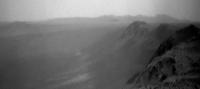
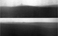
Great map! Here are a couple of Navcam horizon sections from sol 3909 - with a considerable vertical stretch - st show the distant features. I think the sky is clearing a bit, but there's a long way to go.
Phil
-------------------- ... because the Solar System ain't gonna map itself.
Also to be found posting similar content on https://mastodon.social/@PhilStooke Maps for download (free PD: https://upload.wikimedia.org/wikipedia/comm...Cartography.pdf NOTE: everything created by me which I post on UMSF is considered to be in the public domain (NOT CC, public domain) |
|
|
|
|
|
|
Jan 24 2015, 10:16 PM
Post
#85
|
|
|
Senior Member Group: Members Posts: 3516 Joined: 4-November 05 From: North Wales Member No.: 542 |
Thanks fredk for the link to the map, and thanks to the professionals who produced it and made it available. It's exactly what we need. Phil - can you provide a context (or azimuths) for those horizon views? I've been looking hard at one part of the the horizon but I can't locate it in your images.
|
|
|
|
|
Jan 26 2015, 06:58 AM
Post
#86
|
|
|
Senior Member Group: Members Posts: 3516 Joined: 4-November 05 From: North Wales Member No.: 542 |
Finally, a pancam view in the right direction . . I think that's Miyamoto on the left, big and very faint with a smaller hill in front of it.
http://qt.exploratorium.edu/mars/opportuni...BXP2351R1M1.JPG |
|
|
|
|
Jan 26 2015, 06:24 PM
Post
#87
|
|
|
Member Group: Members Posts: 148 Joined: 9-August 11 From: Mason, TX Member No.: 6108 |
Phil's stretched images reminded me of something. While Opportunity is near its current "mountaintop" location in dusty conditions, is it possible that at sundown it could image the mountain-shadow phenomenon that visitors to the top of Mauna Loa often can see?
http://darkerview.com/wordpress/?p=8766 The physics being the same on both worlds, I suspect that it could, since the "point" is more of a trick of perspective and viewpoint than of the steepness of the slopes. But perhaps the altitude is not enough to obtain that perspective. -------------------- --
Don |
|
|
|
|
Jan 26 2015, 09:06 PM
Post
#88
|
||
|
Senior Member Group: Members Posts: 3516 Joined: 4-November 05 From: North Wales Member No.: 542 |
I've had a crude go at tweaking brightness and contrast to bring out the outline of Miyamoto.
Attached thumbnail(s)
|
|
|
|
|
|
|
Jan 26 2015, 10:44 PM
Post
#89
|
|
|
Founder Group: Chairman Posts: 14433 Joined: 8-February 04 Member No.: 1 |
QUOTE (MarsInMyLifetime @ Jan 26 2015, 10:24 AM) is it possible that at sundown it could image the mountain-shadow phenomenon that visitors to the top of Mauna Loa often can see? http://pancam.astro.cornell.edu/pancam_ins...847B_P2445.html Doing anything in color much beyond that time will be hard as fringing between filters will dominate the effect. Navcam might be able to pull something off. |
|
|
|
|
Feb 1 2015, 07:47 PM
Post
#90
|
|
|
Member Group: Members Posts: 154 Joined: 21-April 05 From: Rochester, New York, USA Member No.: 336 |
Just curious. Marathon Valley has been a key objective for years and now it's potentially a few days drive away. Are there any other targets of comparable interest within a few months drive? Curious about the next big goal and the overall mission strategy after this.
<edit: sorry this is probably not the place for this discussion, but I am not seeing an obvious way to delete it> ADMIN: No need to delete, we just moved it from the 'map' thread to here.
|
|
|
|
|
Feb 1 2015, 09:02 PM
Post
#91
|
|
|
Solar System Cartographer Group: Members Posts: 10191 Joined: 5-April 05 From: Canada Member No.: 227 |
Iazu crater has been talked about as a future destination for a while, despite being ridiculously far away (you know, like Endeavour was when we were at Victoria).
So it's interesting to see this at LPSC: http://www.lpi.usra.edu/meetings/lpsc2015/pdf/2548.pdf Nowhere does it say specifically that it's a future destination. But a co-author is Ray Arvidson. So maybe this will be the next goal. It would be several years away. Phil -------------------- ... because the Solar System ain't gonna map itself.
Also to be found posting similar content on https://mastodon.social/@PhilStooke Maps for download (free PD: https://upload.wikimedia.org/wikipedia/comm...Cartography.pdf NOTE: everything created by me which I post on UMSF is considered to be in the public domain (NOT CC, public domain) |
|
|
|
|
Feb 1 2015, 09:44 PM
Post
#92
|
|
|
Member Group: Members Posts: 154 Joined: 21-April 05 From: Rochester, New York, USA Member No.: 336 |
Thanks Phil for that reference. The image on the second page is spectacular.
There is something to be said for driving Opportunity until she fails just to see how far she can go for engineering reasons. I would never bet against her at this point. Part of my question is really about the value of other parts of Endeavor vs. Marathon Valley. Is there any other destination in Endeavor that has major incremental value after Marathon? |
|
|
|
|
Feb 2 2015, 10:21 AM
Post
#93
|
|||||
|
Senior Member Group: Members Posts: 1089 Joined: 19-February 05 From: Close to Meudon Observatory in France Member No.: 172 |
QUOTE (craigmcg @ Feb 1 2015, 10:44 PM) .../... Part of my question is really about the value of other parts of Endeavor vs. Marathon Valley. Is there any other destination in Endeavor that has major incremental value after Marathon? Good question Craigmcg. Lots of interesting minerals were identified from orbit along the rim of Endeavour's (see the 3 illustrations herebelow). So... My gess is that, after the study of Marathon Valley (that will take 1 Earth year at least), we will rove again, following the rim of Endeavour Crater... And this treck will make us going closer and closer to Iazu crater. When we reach Point Hicks (maybe in 2017, who knows ?) and if the rover is still in good health (with many, many technical "ifs"), then we could start our ~12-km traverse on the Meridfiani plain to reach the northmost point of Iazu ejecta that overlooks the Meridiani plains (see the 3rd ansd 4th illustrations : it looks like the Cotentin Peninsula in Normandy, a well-known place by our American, Canadian and British friends who fought the Battle of Normandy in World War II). Marathon Valley is located midway between Victoria Crater and Iazu's cape. Well... there is still a loooong way to go before reaching Iazu crater ! But we have the big chance on our lives to be witnesses of all those exploration feats : maybe we'll see it up close and as we say, "Where there's life, there's hope" !
|
||||
|
|
|
||||
|
Feb 2 2015, 07:34 PM
Post
#94
|
|
|
Senior Member Group: Members Posts: 2090 Joined: 13-February 10 From: Ontario Member No.: 5221 |
On the other hand....
https://twitter.com/CaseyDreier/status/562330771935883264 On page PS-43 of the budget released today (173 in the PDF): QUOTE After a long, productive mission life, Opportunity has started to show signs of age, including recent problems with its flash memory. NASA plans to end Opportunity operations by FY 2016. 
|
|
|
|
|
Feb 2 2015, 07:58 PM
Post
#95
|
|
|
Member Group: Members Posts: 691 Joined: 21-December 07 From: Clatskanie, Oregon Member No.: 3988 |
Not again!
 Picking on the little one is not nice! |
|
|
|
|
Feb 2 2015, 09:34 PM
Post
#96
|
|
 Member Group: Members Posts: 754 Joined: 9-February 07 Member No.: 1700 |
Noooo!
|
|
|
|
|
Feb 2 2015, 09:50 PM
Post
#97
|
|
|
Senior Member Group: Members Posts: 2090 Joined: 13-February 10 From: Ontario Member No.: 5221 |
Planetary Society's Casey Drier says this is actually routine; happened last year, but was fought over, so not a big worry yet.
If it ends up being a choice between Odyssey and Oppy, well....that's going to be a tough one. |
|
|
|
|
Feb 3 2015, 01:32 AM
Post
#98
|
|
|
Senior Member Group: Members Posts: 1585 Joined: 14-October 05 From: Vermont Member No.: 530 |
QUOTE (MarsInMyLifetime @ Jan 26 2015, 01:24 PM) ... the mountain-shadow phenomenon that visitors to the top of Mauna Loa often can see? http://darkerview.com/wordpress/?p=8766 One of these days I have to add a few things to the "Antisolar point" article at wikipedia, because this, along with "Glory" and Brocken spectre and sunbow and everything else that shows up needs some sort of master list. |
|
|
|
|
Feb 4 2015, 07:58 PM
Post
#99
|
||
|
Senior Member Group: Members Posts: 3516 Joined: 4-November 05 From: North Wales Member No.: 542 |
Another glimpse of Miyamoto from sol 3921:
It's actually visible at the far right of Jan's latest Pancam panorama. (Not everyone's priority I know, but it's a lonely mountain on Mars and somebody has to love it.) I'm hopeful that as we descend towards the next crater target we may at last get a pancam view of Bopolu to 'complete the set' of distant features visible from Cape Tribulation.
Attached thumbnail(s)
|
|
|
|
|
|
|
Feb 6 2015, 12:50 AM
Post
#100
|
|
|
Member Group: Members Posts: 706 Joined: 22-April 05 Member No.: 351 |
QUOTE (Explorer1 @ Feb 2 2015, 01:50 PM) If it ends up being a choice between Odyssey and Oppy, well....that's going to be a tough one. I have this vague recollection that Odyssey is expected to run out of fuel sometime in the next couple of years. Does anyone here know for sure? Same thing for LRO (which is also proposed for termination by September)? MRO is projected to be funded (and presumably operating) through 2020, so it apparently has a good fuel supply. -------------------- |
|
|
|
 |

|
Lo-Fi Version | Time is now: 10th June 2024 - 10:49 AM |
|
RULES AND GUIDELINES Please read the Forum Rules and Guidelines before posting. IMAGE COPYRIGHT |
OPINIONS AND MODERATION Opinions expressed on UnmannedSpaceflight.com are those of the individual posters and do not necessarily reflect the opinions of UnmannedSpaceflight.com or The Planetary Society. The all-volunteer UnmannedSpaceflight.com moderation team is wholly independent of The Planetary Society. The Planetary Society has no influence over decisions made by the UnmannedSpaceflight.com moderators. |
SUPPORT THE FORUM Unmannedspaceflight.com is funded by the Planetary Society. Please consider supporting our work and many other projects by donating to the Society or becoming a member. |
|