Venus from Ground Based radar and other |

Venus from Ground Based radar and other |
 Mar 10 2015, 11:50 AM Mar 10 2015, 11:50 AM
Post
#1
|
|
|
Member  Group: Members Posts: 813 Joined: 29-December 05 From: NE Oh, USA Member No.: 627 |
Image Release: Venus, If You Will, as Seen in Radar with the GBT
https://public.nrao.edu/news/pressreleases/venus-surface-gbt Impressive. May be awhile before we return to Venus. Perhaps we need a ground based forum for the time being. Craig |
 |
 
|
 |
|
Mar 10 2015, 04:50 PM
Post
#2
|
|
|
Junior Member Group: Members Posts: 64 Joined: 17-December 12 From: Portugal Member No.: 6792 |
Interesting indeed.
I wonder if some technique could be used to remove the double image effect? -------------------- www.astrosurf.com/nunes
|
|
|
|
|
Mar 10 2015, 05:25 PM
Post
#3
|
|
 Senior Member Group: Members Posts: 2530 Joined: 20-April 05 Member No.: 321 |
QUOTE (4throck @ Mar 10 2015, 09:50 AM)  I wonder if some technique could be used to remove the double image effect? I believe a third transmitter/receiver would definitively solve that problem, but good luck getting a massive radar facility funded for the sole purpose of improving maps of Venus. |
|
|
|
|
Mar 10 2015, 06:36 PM
Post
#4
|
||
|
Senior Member Group: Members Posts: 2346 Joined: 7-December 12 Member No.: 6780 |
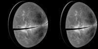
A cross-eyed version:
(derived from B. Campbell, Smithsonian, et al., NRAO/AUI/NSF, Arecibo) |
|
|
|
|
|
|
Mar 10 2015, 07:51 PM
Post
#5
|
|
|
Member Group: Members Posts: 813 Joined: 29-December 05 From: NE Oh, USA Member No.: 627 |
Did not mean to give short shrift to Akatsuki mission.
|
|
|
|
|
Mar 10 2015, 08:45 PM
Post
#6
|
|
|
Solar System Cartographer Group: Members Posts: 10170 Joined: 5-April 05 From: Canada Member No.: 227 |
A third transmitter would help, as suggested, but also the same method applied at a different inferior conjunction will have the Doppler equator (the dark band) in a different location, and all the reflection effects correspondingly moved. By comparing images of different dates the ambiguity can be removed.
There is a long history of radar imaging of Venus, going back 50 years. This is by far the best single image - the bistatic method works really well - but there are many others made monostatically at Goldstone and Arecibo. The brief comments about past work in the press release don't do the subject justice. Anyhoo... there is a good basis for comparison to look for fresh lava flows or other changes. Incidentally, some past results were much higher resolution than this, so I would hope that the image we have is significantly downsampled from the real data. Phil -------------------- ... because the Solar System ain't gonna map itself.
Also to be found posting similar content on https://mastodon.social/@PhilStooke Maps for download (free PD: https://upload.wikimedia.org/wikipedia/comm...Cartography.pdf NOTE: everything created by me which I post on UMSF is considered to be in the public domain (NOT CC, public domain) |
|
|
|
|
Mar 10 2015, 10:09 PM
Post
#7
|
|
|
Member Group: Members Posts: 813 Joined: 29-December 05 From: NE Oh, USA Member No.: 627 |
Phil...
Thanks for the comment. I had no idea ground based radar had gotten this good. When I saw the image it just blew me away. Bodes well for long term monitoring. Seeing the Venera images from Ted Stryk's blog http://planetimages.blogspot.ca/2015/03/ve...hy-we-need.html just brought back to me how little we know about our sister world. At 62 years old wonder how much more we will know in my lifetime. Craig |
|
|
|
|
Mar 10 2015, 10:32 PM
Post
#8
|
|
|
Senior Member Group: Members Posts: 3516 Joined: 4-November 05 From: North Wales Member No.: 542 |
QUOTE (belleraphon1 @ Mar 10 2015, 10:09 PM) When I saw the image it just blew me away.
Me too. I've not seen the radar data presented so well before, so it's a real revelation for us non-experts. At 62 years old wonder how much more we will know in my lifetime. Me too again. A lot I hope. |
|
|
|
|
Mar 10 2015, 11:23 PM
Post
#9
|
|
|
Member Group: Members Posts: 813 Joined: 29-December 05 From: NE Oh, USA Member No.: 627 |
Yeah ngunn
Blessed to have lived through the years from 1962 (Mariner 2) on... what a time. Now there are all those hot super-terrestrial exoplanets discovered (sorry, really dislike the term SuperEarth. These are nothing like Earth). Venus can teach us so much. Ok, done preaching, lol. Craig |
|
|
|
|
Mar 11 2015, 07:42 PM
Post
#10
|
|
|
Member Group: Members Posts: 706 Joined: 22-April 05 Member No.: 351 |
Has anyone seen what the resolution was for this Earth-based observation?
-------------------- |
|
|
|
|
Mar 19 2015, 05:17 AM
Post
#11
|
|
|
Solar System Cartographer Group: Members Posts: 10170 Joined: 5-April 05 From: Canada Member No.: 227 |
I have not seen the resolution for this image, but check out this page:
http://www.naic.edu/~pradar/radarpage.html for some images from 1999 - 2001 including a small one at 1.2 km/pixel. Also you can poke around here... some at least are 50 pixels/degree or about 2 km. http://pds-geosciences.wustl.edu/premgn/mg...bvenus/arecibo/ Phil -------------------- ... because the Solar System ain't gonna map itself.
Also to be found posting similar content on https://mastodon.social/@PhilStooke Maps for download (free PD: https://upload.wikimedia.org/wikipedia/comm...Cartography.pdf NOTE: everything created by me which I post on UMSF is considered to be in the public domain (NOT CC, public domain) |
|
|
|
 |

|
Lo-Fi Version | Time is now: 28th May 2024 - 02:07 PM |
|
RULES AND GUIDELINES Please read the Forum Rules and Guidelines before posting. IMAGE COPYRIGHT |
OPINIONS AND MODERATION Opinions expressed on UnmannedSpaceflight.com are those of the individual posters and do not necessarily reflect the opinions of UnmannedSpaceflight.com or The Planetary Society. The all-volunteer UnmannedSpaceflight.com moderation team is wholly independent of The Planetary Society. The Planetary Society has no influence over decisions made by the UnmannedSpaceflight.com moderators. |
SUPPORT THE FORUM Unmannedspaceflight.com is funded by the Planetary Society. Please consider supporting our work and many other projects by donating to the Society or becoming a member. |
|