New Horizons: Near Encounter Phase |

New Horizons: Near Encounter Phase |
 Mar 11 2015, 01:49 AM Mar 11 2015, 01:49 AM
Post
#1
|
|
 Administrator  Group: Admin Posts: 5172 Joined: 4-August 05 From: Pasadena, CA, USA, Earth Member No.: 454 |
The plans for the Near Encounter Phase of the New Horizons mission have been set in stone since 2009. This week the mission has posted a Playbook that describes all the data that is going to be returned from the Near Encounter Phase -- not only the timing and geometry, but also when it is going to be played back. I also posted an article today about the data that will be played back during the couple of weeks surrounding closest approach. Some of the things I learned while writing that article that are of interest to this forum:
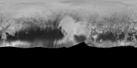
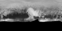
- Not a lot of data is being returned right away (in fact, only 1% gets returned within a week of the flyby). - After July 20, there will be a long dry spell of no images being returned until the browse data set starts coming down on September 16. - There will not be much scope for image processing on the data that is being returned near the flyby. There are one or two pairs of images that you can use to make stereo; there are two mosaics; there is one MVIC image for which there is LORRI data returned near enough in time to do colorization. So it's going to be awesome, but we're also going to have to be patient! Here is my simulation, using Voyager data, of the LORRI data set that we can expect to have on the ground as of July 20. 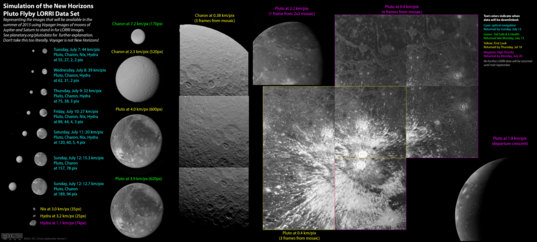
-------------------- My website - My Patreon - @elakdawalla on Twitter - Please support unmannedspaceflight.com by donating here.
|
 |
 
|
 |
|
Mar 19 2015, 12:03 AM
Post
#2
|
|
|
Junior Member Group: Members Posts: 88 Joined: 8-May 14 Member No.: 7185 |
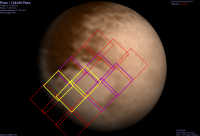
Thanks so much for this very informative chart. Is the entire New-Horizons-facing Pluto hemisphere expected to be documented at 0.4km/pix resolution?
|
|
|
|
|
Mar 19 2015, 02:54 PM
Post
#3
|
|
|
Administrator Group: Admin Posts: 5172 Joined: 4-August 05 From: Pasadena, CA, USA, Earth Member No.: 454 |
Not all of it; there is a 15-footprint mosaic that covers maybe 30% of the visible disk. It's on page 20 of the Playbook I linked to in my post.
-------------------- My website - My Patreon - @elakdawalla on Twitter - Please support unmannedspaceflight.com by donating here.
|
|
|
|
|
Mar 20 2015, 08:28 PM
Post
#4
|
|
|
Junior Member Group: Members Posts: 88 Joined: 8-May 14 Member No.: 7185 |
Thank you! - Your chart is an excellent overview of the visuals to expect. The playbook has all the info, but your graphic is more digestible for those of us with limited time due to real life constraits (i.e. job and toddlers :-)
|
|
|
|
|
Mar 21 2015, 08:32 AM
Post
#5
|
||
 Junior Member Group: Members Posts: 66 Joined: 3-August 12 Member No.: 6454 |
That's interesting.....
So, what happens between the time of the 15 highest-rez photos from 77,298km range (p.20) and the time when lower-rez photos are taken before (254,072km range, p.17) and after (359,895km range, p.22) ? I realize it's all done on July 14, but just how long does it take to get each of the 15 hi-rez photos? ....one might be tempted to think that a more complete hemispheric coverage could be had. Why not ? (Thnx)
|
|
|
|
|
|
|
Mar 21 2015, 08:45 AM
Post
#6
|
|
|
Merciless Robot Group: Admin Posts: 8784 Joined: 8-December 05 From: Los Angeles Member No.: 602 |
Primarily because NH's downlink bit-rate at that distance will be around 1kb/sec. Also, imagery obviously won't be the only data coming down and the DSN is a finite resource set that can't be dedicated to NH alone.
Excellent (as always) relevant blog article by Emily here. -------------------- A few will take this knowledge and use this power of a dream realized as a force for change, an impetus for further discovery to make less ancient dreams real.
|
|
|
|
|
Mar 21 2015, 11:11 AM
Post
#7
|
|
|
Junior Member Group: Members Posts: 95 Joined: 5-September 07 Member No.: 3662 |
QUOTE (Jaro_in_Montreal @ Mar 21 2015, 03:32 AM)  That's interesting..... So, what happens between the time of the 15 highest-rez photos from 77,298km range (p.20) and the time when lower-rez photos are taken before (254,072km range, p.17) and after (359,895km range, p.22) ? I realize it's all done on July 14, but just how long does it take to get each of the 15 hi-rez photos? ....one might be tempted to think that a more complete hemispheric coverage could be had. Why not ? (Thnx) A couple of possibilities come to mind, but they all lead back to a mix of too little time and finite storage capacity, and lots of choices on how to spend them. If you look at the last panel in the figure you attached, you can see that it would take about 3x as many images to cover the expected error ellipse to be sure of getting the whole planet, so 3x as much time and 3x as much data. This flyby isn't just about imaging, and there are tradeoffs, and I bet the meeting where the 15 images were settled upon was "interesting." Spectroscopy and occultations are also on the list, and those are going to take time and data as well. Since NH has to turn the whole spacecraft to point the instruments, it's not possible to get useful data from all the instruments at the same time. And don't forget the satellites, we want data on those as well. But my gut tells me it's probably the amount of storage available on the spacecraft that limits the number of images, in the end. Maybe John will chime in to give the real answer. Jeff |
|
|
|
|
Mar 21 2015, 02:45 PM
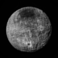
Post
#8
|
|
 Member Group: Members Posts: 701 Joined: 3-December 04 From: Boulder, Colorado, USA Member No.: 117 |
The scarcest resource during the close approach period is time rather than data volume. The spacecraft is designed to do fast turns (up to 1.25 degree/sec) to observe as many targets as possible during the close approach period, but still, each mosaic repointing takes time to settle before we can be sure of a sharp image, time is needed to allocate the memory for recording each set of data, and so on. To answer the specific question, that 15-image Pluto mosaic takes about 20 minutes, and is preceded by Nix observations (hi-res imaging and our best infrared compositional map), and followed by our best infrared compositional map of Charon.
We do get most of the visible disk of Pluto at 0.3 km/pixel with our wide-angle camera MVIC near closest approach, and the whole disk at 0.46 km/pixel with MVIC ten minutes earlier- part of the purpose of that 15-image LORRI mosaic is to provide stereo coverage with the closer MVIC scans. There were indeed many lively meetings to figure all this out, but they were almost never acrimonious- the entire science team understands the importance of the holistic view of the system that will be provided by all these wonderful overlapping data sets. John |
|
|
|
|
Mar 21 2015, 03:54 PM
Post
#9
|
|
|
Member Group: Members Posts: 529 Joined: 19-February 05 Member No.: 173 |
QUOTE (john_s @ Mar 21 2015, 03:45 PM) The scarcest resource during the close approach period is time rather than data volume. The spacecraft is designed to do fast turns (up to 1.25 degree/sec) to observe as many targets as possible during the close approach period, but still, each mosaic repointing takes time to settle before we can be sure of a sharp image, time is needed to allocate the memory for recording each set of data, and so on. To answer the specific question, that 15-image Pluto mosaic takes about 20 minutes, and is preceded by Nix observations (hi-res imaging and our best infrared compositional map), and followed by our best infrared compositional map of Charon. We do get most of the visible disk of Pluto at 0.3 km/pixel with our wide-angle camera MVIC near closest approach, and the whole disk at 0.46 km/pixel with MVIC ten minutes earlier- part of the purpose of that 15-image LORRI mosaic is to provide stereo coverage with the closer MVIC scans. There were indeed many lively meetings to figure all this out, but they were almost never acrimonious- the entire science team understands the importance of the holistic view of the system that will be provided by all these wonderful overlapping data sets. John John is right, the NH sequence planning team for Pluto encounter was exceptionally collegial. The mapping he describes beats the NASA spec requirement for hemispheric mapping of 1 km by a healthy margin, and adds the high-res mosaic. We beat NASA spec for Pluto color mapping and composition mapping by healthy margins too. Amazing data sets are in store! |
|
|
|
|
Mar 21 2015, 05:54 PM
Post
#10
|
|
|
Junior Member Group: Members Posts: 95 Joined: 5-September 07 Member No.: 3662 |
QUOTE (Alan Stern @ Mar 21 2015, 10:54 AM) John is right, the NH sequence planning team for Pluto encounter was exceptionally collegial. The mapping he describes beats the NASA spec requirement for hemispheric mapping of 1 km by a healthy margin, and adds the high-res mosaic. We beat NASA spec for Pluto color mapping and composition mapping by healthy margins too. Amazing data sets are in store! Shows what I know!  Thanks John and Alan! |
|
|
|
|
Mar 21 2015, 06:35 PM
Post
#11
|
|
|
Senior Member Group: Members Posts: 1276 Joined: 25-November 04 Member No.: 114 |
Jaro where did you get that image from?
|
|
|
|
|
Mar 21 2015, 06:40 PM
Post
#12
|
|
|
Senior Member Group: Members Posts: 2346 Joined: 7-December 12 Member No.: 6780 |
Page 20 of the Observation Playbook.
|
|
|
|
|
Mar 21 2015, 07:10 PM
Post
#13
|
|
|
Member Group: Members Posts: 529 Joined: 19-February 05 Member No.: 173 |
QUOTE (Gerald @ Mar 21 2015, 06:40 PM) Page 20 of the Observation Playbook. One note, this is only one of several Observation Playbooks. Others will be posted later on approach, covering other instruments and disciplines beyond just surface mapping by LORRI and MVIC. Stay tuned... |
|
|
|
|
Mar 21 2015, 10:52 PM
Post
#14
|
|
 Director of Galilean Photography Group: Members Posts: 896 Joined: 15-July 04 From: Austin, TX Member No.: 93 |
QUOTE (Alan Stern @ Mar 21 2015, 02:10 PM) Stay tuned... Thanks Alan for letting us "in the conference room!" -------------------- Space Enthusiast Richard Hendricks
-- "The engineers, as usual, made a tremendous fuss. Again as usual, they did the job in half the time they had dismissed as being absolutely impossible." --Rescue Party, Arthur C Clarke Mother Nature is the final inspector of all quality. |
|
|
|
|
Mar 22 2015, 04:45 AM
Post
#15
|
|
 Lord Of The Uranian Rings Group: Members Posts: 798 Joined: 18-July 05 From: Plymouth, UK Member No.: 437 |
Seconded!
-------------------- |
|
|
|
|
Mar 22 2015, 05:33 AM
Post
#16
|
|
|
Newbie Group: Members Posts: 4 Joined: 25-January 14 Member No.: 7110 |
Thirded! I haven't been this excited since Voyager 2 encountered Neptune back in 1989!
|
|
|
|
|
Mar 22 2015, 07:57 PM
Post
#17
|
|
 Member Group: Members Posts: 495 Joined: 12-February 12 Member No.: 6336 |
Thank you for letting us get an insight via your "Observation Playbook".
I can only echo what already been said, that this will indeed be one interesting encounter. Now I hope you give NH another good workout so she wont sprain a muscle during that intense cosmic ballet performance. =) |
|
|
|
|
Mar 23 2015, 02:05 AM
Post
#18
|
|
 Interplanetary Dumpster Diver Group: Admin Posts: 4404 Joined: 17-February 04 From: Powell, TN Member No.: 33 |
I will chime in and say that a major part in New Horizons success thus far has been its team dynamic. I have been amazed, given the competing priorities, at the cooperative spirit with which things are dealt with.
-------------------- |
|
|
|
|
Jul 13 2015, 01:53 PM
Post
#19
|
|
|
Merciless Robot Group: Admin Posts: 8784 Joined: 8-December 05 From: Los Angeles Member No.: 602 |
Good morning from Los Angeles! Today marks the beginning of the near encounter phase. NASA TV will air the pre-flyby briefing at 1430 GMT today (13 Jul). Note that all times are subject to change as events unfold.
Please utilize this thread for all New Horizons commentary for the next several days. Here we go!!!  -------------------- A few will take this knowledge and use this power of a dream realized as a force for change, an impetus for further discovery to make less ancient dreams real.
|
|
|
|
|
Jul 13 2015, 02:09 PM
Post
#20
|
|
|
Member Group: Members Posts: 137 Joined: 16-June 15 Member No.: 7507 |
One thing that was being discussed in the last thread, about all of the features that look like "rivers" or "lakes" and the criticism that Pluto's pressure is too low for, say, liquid nitrogen to flow:
Given a triple point pressure of around 12kPa and a solid density of 1027 kg/m^3, 3,2kPa surface pressure, and 0,655m/s^2 pluto surface gravity, Pluto's triple point could be hit underneath as little as 13 meters of nitrogen ice (a bit more, as it would have to have at least a tiny bit of "fluff" to it to float, but that's to be expected). Other ices floating on it such as methane ice could have the same effect. And note that this ice wouldn't be heavily packed due to Pluto's weak gravity, it's the equivalent of less than one meter of nitrogen ice under Earth's gravity. Picture how much a meter of water snow (roughly the same density) packs down on Earth; I'd expect something roughly in the same ballpark - perhaps a situation like arctic sea ice. Basically, even if there's not liquids flowing on the surface (eutectics or whatnot), there could still be liquids at a shallow depth with a weak ice pack on top of them. And iced-over rivers still flow and move things around. |
|
|
|
|
Jul 13 2015, 02:14 PM
Post
#21
|
|
 Junior Member Group: Members Posts: 98 Joined: 30-November 05 From: Antibes, France Member No.: 594 |
Thanks for the analysis and the calculations Nafnlaus. That's the relevant problem. I was intersted in peforming that kind of simulations. No need to dig deep for the future lander if you're right.
 |
|
|
|
|
Jul 13 2015, 02:20 PM
Post
#22
|
|
|
Member Group: Members Posts: 137 Joined: 16-June 15 Member No.: 7507 |
An interesting thing is that there's a lot of potential liquids and mixtures of liquids / slushes / etc at different (shallow) depths that could be involved here, going through a wide range of dynamic changes as Pluto moves through its seasons. There could be some very complex processes involved in shaping this landscape. I'm sure whatever data comes back, it's going to lead to some very interesting papers down the road
|
|
|
|
|
Jul 13 2015, 02:29 PM
Post
#23
|
|
|
Merciless Robot Group: Admin Posts: 8784 Joined: 8-December 05 From: Los Angeles Member No.: 602 |
Briefing placard now up on NASA TV.
-------------------- A few will take this knowledge and use this power of a dream realized as a force for change, an impetus for further discovery to make less ancient dreams real.
|
|
|
|
|
Jul 13 2015, 02:31 PM
Post
#24
|
|
|
Senior Member Group: Members Posts: 2088 Joined: 13-February 10 From: Ontario Member No.: 5221 |
Starting now....
|
|
|
|
|
Jul 13 2015, 02:34 PM
Post
#25
|
|
 IMG to PNG GOD Group: Moderator Posts: 2251 Joined: 19-February 04 From: Near fire and ice Member No.: 38 |
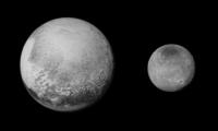
I have been attempting to measure Pluto's radius from the images that have been obtained in the past few days. I have consistently been getting a values of 1190-1195 km in most cases (1194 km for the latest image). This is close to the radius that SPICE uses (1195 km) but I have seen smaller values elsewhere. Wikipedia gives two values, 1184 km and "1161 km (solid)". The PDS Rings Node Pluto Viewer seems to use a value of 1153 km (selectable in "Field of View" but I'm not completely sure this is the value used to render the Pluto diagrams - I suspect that value may be bigger).
I haven't measured Charon as thoroughly and not in the latest images but I have usually gotten values of 590-600 km. This isn't very far from the SPICE value (605 km). |
|
|
|
|
Jul 13 2015, 02:36 PM
Post
#26
|
|
|
Merciless Robot Group: Admin Posts: 8784 Joined: 8-December 05 From: Los Angeles Member No.: 602 |
Pluto's polar cap confirmed as N2 & CH4 ices.
Alan states radius as 1185 km +/- 10. -------------------- A few will take this knowledge and use this power of a dream realized as a force for change, an impetus for further discovery to make less ancient dreams real.
|
|
|
|
|
Jul 13 2015, 02:39 PM
Post
#27
|
|
|
IMG to PNG GOD Group: Moderator Posts: 2251 Joined: 19-February 04 From: Near fire and ice Member No.: 38 |
QUOTE (nprev @ Jul 13 2015, 02:36 PM) Alan states radius as 1185 km +/- 10. Saw this on NASA TV, nice to see measurements from the NH team only minutes after I posted my (much more crude) measurements here. |
|
|
|
|
Jul 13 2015, 02:51 PM
Post
#28
|
|
|
Merciless Robot Group: Admin Posts: 8784 Joined: 8-December 05 From: Los Angeles Member No.: 602 |
By my count, we now have three different pronunciations of "Charon".
-------------------- A few will take this knowledge and use this power of a dream realized as a force for change, an impetus for further discovery to make less ancient dreams real.
|
|
|
|
|
Jul 13 2015, 02:56 PM
Post
#29
|
|
 Senior Member Group: Members Posts: 1729 Joined: 3-August 06 From: 43° 35' 53" N 1° 26' 35" E Member No.: 1004 |
given how it's written in Greek, "kharon" is the correct one
|
|
|
|
|
Jul 13 2015, 03:01 PM
Post
#30
|
|
|
Member Group: Members Posts: 112 Joined: 31-January 15 From: Houston, TX USA Member No.: 7390 |
QUOTE (Paolo @ Jul 13 2015, 08:56 AM) given how it's written in Greek, "kharon" is the correct one However, the discoverer's wife's name is Charlene. Therefore the pronunciation is similar to Sharon (or Charlene). Wives usually win... |
|
|
|
|
Jul 13 2015, 03:18 PM
Post
#31
|
|
|
Solar System Cartographer Group: Members Posts: 10182 Joined: 5-April 05 From: Canada Member No.: 227 |
This is absolutely a case where space nerds win out over linguist nerds. The name is only pretending to be Greek. The moon is actually named after the discoverer's wife and is just modified slightly to look like it's mythological, to pass IAU inspection.
Phil -------------------- ... because the Solar System ain't gonna map itself.
Also to be found posting similar content on https://mastodon.social/@PhilStooke Maps for download (free PD: https://upload.wikimedia.org/wikipedia/comm...Cartography.pdf NOTE: everything created by me which I post on UMSF is considered to be in the public domain (NOT CC, public domain) |
|
|
|
|
Jul 13 2015, 03:28 PM
Post
#32
|
|
|
Member Group: Members Posts: 282 Joined: 18-June 04 Member No.: 84 |
excellent and informative briefing so far I must say
|
|
|
|
|
Jul 13 2015, 03:28 PM
Post
#33
|
|
|
Merciless Robot Group: Admin Posts: 8784 Joined: 8-December 05 From: Los Angeles Member No.: 602 |
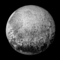
The early, distant detection of ionized nitrogen seems to be the most unexpected thing thus far.
Presser wrapping up. -------------------- A few will take this knowledge and use this power of a dream realized as a force for change, an impetus for further discovery to make less ancient dreams real.
|
|
|
|
|
Jul 13 2015, 03:30 PM
Post
#34
|
|
|
Senior Member Group: Members Posts: 1018 Joined: 29-November 05 From: Seattle, WA, USA Member No.: 590 |
Does anyone have an estimate of how much of Pluto will not be imaged at all? Either because it's in the dark or just due to the geometry of the encounter?
Best would be a contour map showing resolution in different regions, but just a measure of the invisible amount would be interesting. Same for Charon. |
|
|
|
|
Jul 13 2015, 03:30 PM
Post
#35
|
|
|
Senior Member Group: Members Posts: 1729 Joined: 3-August 06 From: 43° 35' 53" N 1° 26' 35" E Member No.: 1004 |
yep, though I expected to see the few LORRI images from yesterday
|
|
|
|
|
Jul 13 2015, 03:33 PM
Post
#36
|
|
|
Member Group: Members Posts: 112 Joined: 31-January 15 From: Houston, TX USA Member No.: 7390 |
If I followed Dr. Stern correctly, molecular nitrogen was found five days out of closest approach. Actually at that distance it was ionized nitrogen and is believed to have come from Pluto. The detection was significantly further out than had been expected which *implies* some type of more energetic release mechanism on Pluto. However, the data resolution is too low to really tell at this point.
Also, the methane signature of Pluto's dark regions is significantly lower than that of the polar region. We all get to add this new information to our image interpretations... Andy |
|
|
|
|
Jul 13 2015, 03:38 PM
Post
#37
|
||
|
IMG to PNG GOD Group: Moderator Posts: 2251 Joined: 19-February 04 From: Near fire and ice Member No.: 38 |
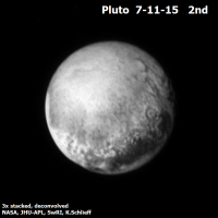
New version of my Pluto map where I have added the 2015-07-11 22:23 image that was released by the NH team last night if I remember correctly (things are happening fast now!). Longitude 0 is at the left edge of the map.
Of course this is probably only hours (or possibly even minutes) from getting completely outdated - and if I want to keep the map up to date I soon need to make a bigger version. |
|
|
|
|
|
|
Jul 13 2015, 03:42 PM
Post
#38
|
|
 Member Group: Members Posts: 710 Joined: 28-September 04 Member No.: 99 |
1 million km.
|
|
|
|
|
Jul 13 2015, 03:42 PM
Post
#39
|
|
|
Merciless Robot Group: Admin Posts: 8784 Joined: 8-December 05 From: Los Angeles Member No.: 602 |
Next media event will be tomorrow 14 Jul/1130 GMT for closest approach, followed by a presser/image release.
-------------------- A few will take this knowledge and use this power of a dream realized as a force for change, an impetus for further discovery to make less ancient dreams real.
|
|
|
|
|
Jul 13 2015, 03:48 PM
Post
#40
|
|
|
Junior Member Group: Members Posts: 75 Joined: 8-July 15 Member No.: 7566 |
Is the media conference going to be uploaded to youtube? I missed it.
|
|
|
|
|
Jul 13 2015, 03:52 PM
Post
#41
|
||
|
Member Group: Members Posts: 102 Joined: 12-August 12 Member No.: 6540 |
QUOTE (nprev @ Jul 13 2015, 11:42 AM) Next media event will be tomorrow 14 Jul/1130 GMT for closest approach, followed by a presser/image release. Things are happening fast now. As mentioned in a previous briefing, we may not see all the data for awhile. But I'm sure they will put out some images and data this week. I "accidentally" took a screen grab from a monitor during a live feed from NH Mission Operations today:
It sure doesn't look like telemetry data. Although it's too small to be useful, if it is an image of Pluto or Charon, it could be a teaser of the kind of resolution and detail we can soon expect. Personally, I think it could be a close up on Pluto... |
|
|
|
|
|
|
Jul 13 2015, 03:57 PM
Post
#42
|
|
 Member Group: Members Posts: 423 Joined: 13-November 14 From: Norway Member No.: 7310 |
Björn's map illustrates how the bright areas to the west in the last image release is probably (at the least) a half-decent preview of the rest of heart feature. The bright stuff here is probably similar to the bright stuff in the rest of it. Judging by lower-resolution maps, there were already solid hints that this part would not be some sort of uniform white, however.
-------------------- |
|
|
|
|
Jul 13 2015, 04:01 PM
Post
#43
|
|
|
Member Group: Members Posts: 362 Joined: 13-April 06 From: Malta Member No.: 741 |
The fact that our closest approach view will include the brightest region and part of the dark region together with other parts in between albedos ,should give us a good representation of all terrain types visualized so far on pluto.
|
|
|
|
|
Jul 13 2015, 04:02 PM
Post
#44
|
|
|
Junior Member Group: Members Posts: 30 Joined: 15-June 15 Member No.: 7506 |
|
|
|
|
|
Jul 13 2015, 04:20 PM
Post
#45
|
|
 Member Group: Members Posts: 112 Joined: 20-August 12 From: Spain Member No.: 6597 |
Just updated the New Horizons image database: http://nchazarra.duckdns.org/db/
Now you can also download the whole records in .csv. |
|
|
|
|
Jul 13 2015, 04:38 PM
Post
#46
|
|
|
Merciless Robot Group: Admin Posts: 8784 Joined: 8-December 05 From: Los Angeles Member No.: 602 |
Omnibus New Horizons info post now up at the Planetary Society blog.
-------------------- A few will take this knowledge and use this power of a dream realized as a force for change, an impetus for further discovery to make less ancient dreams real.
|
|
|
|
|
Jul 13 2015, 04:42 PM
Post
#47
|
||
|
Forum Contributor Group: Members Posts: 1372 Joined: 8-February 04 From: North East Florida, USA. Member No.: 11 |
QUOTE (Marvin @ Jul 13 2015, 04:52 PM) Things are happening fast now. As mentioned in a previous briefing, we may not see all the data for awhile. But I'm sure they will put out some images and data this week. I "accidentally" took a screen grab from a monitor during a live feed from NH Mission Operations today:
It sure doesn't look like telemetry data. Although it's too small to be useful, if it is an image of Pluto or Charon, it could be a teaser of the kind of resolution and detail we can soon expect. Personally, I think it could be a close up on Pluto... I thought it was the NASA TV feed, they were watching themselves on NASA TV, for a few mins. |
|
|
|
|
|
|
Jul 13 2015, 04:44 PM
Post
#48
|
|
|
Member Group: Members Posts: 495 Joined: 12-February 12 Member No.: 6336 |
QUOTE (paraisosdelsistemasolar @ Jul 13 2015, 06:20 PM) Just updated the New Horizons image database: http://nchazarra.duckdns.org/db/ Now you can also download the whole records in .csv. Good work, and thank you for including all that information for the images. I bet it will useful for the image tweakers on this forum. =) |
|
|
|
|
Jul 13 2015, 04:46 PM
Post
#49
|
|
 Senior Member Group: Members Posts: 2530 Joined: 20-April 05 Member No.: 321 |
QUOTE (alk3997 @ Jul 13 2015, 08:33 AM) Also, the methane signature of Pluto's dark regions is significantly lower than that of the polar region. I guess the leading candidates for the dark stuff are some combination of: 1) Larger hydrocarbons, tholins, maybe the nitriles, etc. seen on Titan. 2) Varied grain sizes that appear darker for physical rather than chemical reasons. There could be very interesting chemistry which will be difficult to interpret from a distance. We still don't know what the composition of the bulk of Titan's surface is, and NH will return a minuscule fraction of the observations of Pluto that Cassini-Huygens returned from Titan. The only compensation is that spectroscopy of Pluto's surface should not be impaired too much by the atmosphere. |
|
|
|
|
Jul 13 2015, 04:50 PM
Post
#50
|
|
|
Member Group: Members Posts: 102 Joined: 12-August 12 Member No.: 6540 |
QUOTE (MahFL @ Jul 13 2015, 12:42 PM) I thought it was the NASA TV feed, they were watching themselves on NASA TV, for a few mins. Yes, it was on NASA TV, a live feed of Mission Operations after the presentation. You could sense their excitement, and I don't blame them. Edit: I just finished watching the replay Req kindly put up on the previous page. Start watching at around 60:42. One of the other staff comes over to check out the image I posted. Looks interesting! There is actually an earlier image to the one I posted if anyone wants to try to grab it. |
|
|
|
|
Jul 13 2015, 04:53 PM
Post
#51
|
|
|
Newbie Group: Members Posts: 1 Joined: 2-December 14 Member No.: 7358 |
QUOTE (paraisosdelsistemasolar @ Jul 13 2015, 06:20 PM) Just updated the New Horizons image database: http://nchazarra.duckdns.org/db/ Now you can also download the whole records in .csv. Very nice, thank you! Don't test on the live site, your PHP errors were showing! Could you put a TARGET field on the index table? NH is now specifying whether the target is PLUTO or CHARON, and presumably the other moons may be targeted as well. It would be nice to see this right on the index table. If you want to clean up that table, I would say that the compression, exposure, and missionphase fields are not really needed on the index table. It doesn't hurt to have them, but it makes the table too wide. Perhaps putting the Show Detail link on the left, instead of on the right, would help in that regard. Again, thank you for the terrific index! |
|
|
|
|
Jul 13 2015, 04:55 PM
Post
#52
|
|
 Member Group: Members Posts: 916 Joined: 15-June 09 From: Lisbon, Portugal Member No.: 4824 |
QUOTE (Phil Stooke @ Jul 13 2015, 04:18 PM) This is absolutely a case where space nerds win out over linguist nerds. Phil Learn something new everyday! I had always thought it was named after the ferryman from Hades, which would be appropriate since Hades is the ancient name of the underworld god: Pluto. Well disguised indeed! Fenando |
|
|
|
|
Jul 13 2015, 05:01 PM
Post
#53
|
|
 Senior Member Group: Members Posts: 1887 Joined: 20-November 04 From: Iowa Member No.: 110 |
QUOTE (nprev @ Jul 13 2015, 09:36 AM) Pluto's polar cap confirmed as N2 & CH4 ices. Alan states radius as 1185 km +/- 10. Bigger than Eris (1165 +/-6 km) |
|
|
|
|
Jul 13 2015, 05:07 PM
Post
#54
|
||
 Senior Member Group: Members Posts: 4250 Joined: 17-January 05 Member No.: 152 |
It's fun to combine Bjorn's maps into an animation showing how the resolution is increasing, from east to west:
|
|
|
|
|
|
|
Jul 13 2015, 05:15 PM
Post
#55
|
|
|
Solar System Cartographer Group: Members Posts: 10182 Joined: 5-April 05 From: Canada Member No.: 227 |
Jim Christie has a good account of the naming of Charon in this interview:
http://www.astronomy.com/year-of-pluto/201...t-double-planet Phil -------------------- ... because the Solar System ain't gonna map itself.
Also to be found posting similar content on https://mastodon.social/@PhilStooke Maps for download (free PD: https://upload.wikimedia.org/wikipedia/comm...Cartography.pdf NOTE: everything created by me which I post on UMSF is considered to be in the public domain (NOT CC, public domain) |
|
|
|
|
Jul 13 2015, 05:25 PM
Post
#56
|
|
|
Member Group: Members Posts: 112 Joined: 20-August 12 From: Spain Member No.: 6597 |
NASA has blocked the access to the root of the directories where images and metadata is stored, so the database won't be updating until I find a way to parse the web code.
|
|
|
|
|
Jul 13 2015, 05:26 PM
Post
#57
|
||
 Member Group: Members Posts: 714 Joined: 3-January 08 Member No.: 3995 |
New images of Pluto and Charon just released:
http://www.nasa.gov/feature/how-big-is-plu...des-long-debate
|
|
|
|
|
|
|
Jul 13 2015, 05:40 PM
Post
#58
|
|
|
Member Group: Members Posts: 495 Joined: 12-February 12 Member No.: 6336 |
And that same webpage provide a new diameter value for Pluto, bringing Pluto back at the top of the list in the KBO family.
(The statement for the diameter of Pluto is 2,370 kilometers, Charon get 1208 km, for Nix there's an estimate of 35 kilometers, and Hydra at 45 kilometers.) |
|
|
|
|
Jul 13 2015, 05:40 PM
Post
#59
|
|
|
Senior Member Group: Members Posts: 2922 Joined: 14-February 06 From: Very close to the Pyrénées Mountains (France) Member No.: 682 |
Much more details here! This looks like giant dark sand dunes.
-------------------- |
|
|
|
|
Jul 13 2015, 05:42 PM
Post
#60
|
|
|
Junior Member Group: Members Posts: 31 Joined: 1-July 13 From: Ithaca, NY Member No.: 6966 |
QUOTE (nprev @ Jul 13 2015, 10:36 AM) Alan states radius as 1185 km +/- 10. QUOTE (Gladstoner @ Jul 13 2015, 01:26 PM) These two sources don't seem to match up. The article linked above states: QUOTE Mission scientists have found Pluto to be 1,473 miles (2,370 kilometers) in diameter... and QUOTE ...observations of Charon confirm previous estimates of 751 miles (1208 km) kilometers) across. EDIT: TheAnt just said the same thing. |
|
|
|
| Guest_alex_k_* |
Jul 13 2015, 05:43 PM
Post
#61
|
||
|
Guests |
My processing of 11 of July, 22:22. Factor x3, north is up.
Pluto:
Charon:
|
||
|
|
|
||
|
Jul 13 2015, 05:46 PM
Post
#62
|
||
 Senior Member Group: Moderator Posts: 3233 Joined: 11-February 04 From: Tucson, AZ Member No.: 23 |
I had completely forgotten about the observation playbook! In that case, I can update my P_LORRI_STEREO_MOSAIC preview to show which frames will be played back this month (using the colors Emily used in her graphic earlier). So the Yellow frames are supposed to be played back Wednesday evening UTC, while the purple frames are supposed to be played back on the afternoon of July 20 UTC.
Blake, maybe you're confusing radius and diameter? Diameter = Radius x 2 -------------------- &@^^!% Jim! I'm a geologist, not a physicist!
The Gish Bar Times - A Blog all about Jupiter's Moon Io |
|
|
|
|
|
|
Jul 13 2015, 05:46 PM
Post
#63
|
||
|
Solar System Cartographer Group: Members Posts: 10182 Joined: 5-April 05 From: Canada Member No.: 227 |
Just playing with contrast in the brighter areas of Pluto and the terminators to make details easier to see.
Phil
-------------------- ... because the Solar System ain't gonna map itself.
Also to be found posting similar content on https://mastodon.social/@PhilStooke Maps for download (free PD: https://upload.wikimedia.org/wikipedia/comm...Cartography.pdf NOTE: everything created by me which I post on UMSF is considered to be in the public domain (NOT CC, public domain) |
|
|
|
|
|
|
Jul 13 2015, 05:47 PM
Post
#64
|
|
|
Member Group: Members Posts: 112 Joined: 31-January 15 From: Houston, TX USA Member No.: 7390 |
QUOTE (blake @ Jul 13 2015, 12:42 PM) These two sources don't seem to match up. The article linked above states: and EDIT: TheAnt just said the same thing. 1185km radius x 2 = 2370km diameter I guess I'm missing what doesn't "add up"? Andy |
|
|
|
|
Jul 13 2015, 05:53 PM
Post
#65
|
||
|
Merciless Robot Group: Admin Posts: 8784 Joined: 8-December 05 From: Los Angeles Member No.: 602 |
QUOTE (Gladstoner @ Jul 13 2015, 10:26 AM)
Astonishing detail on Pluto now, including apparent topography. There seem to be two distinct types of dark terrain. The part facing the camera looks like rugged highlands, but the part rotating into view at 7 o'clock looks flat, featureless, and much darker. -------------------- A few will take this knowledge and use this power of a dream realized as a force for change, an impetus for further discovery to make less ancient dreams real.
|
|
|
|
|
|
|
Jul 13 2015, 05:54 PM
Post
#66
|
|
|
Senior Member Group: Members Posts: 2530 Joined: 20-April 05 Member No.: 321 |
To my eye, the dark blotches on the Whale hemisphere seem to have smoothly curving boundaries, while the dark areas on the anti-Whale hemisphere seem to have more irregular boundaries. I'm curious now if that's because they're categorically different or if it's the same materials but differences in topography. (Such as the difference between the jagged coastline of Greece vs. the smooth coastlines of Florida.)
|
|
|
|
|
Jul 13 2015, 05:58 PM
Post
#67
|
|
|
Member Group: Members Posts: 714 Joined: 3-January 08 Member No.: 3995 |
QUOTE (climber @ Jul 13 2015, 11:40 AM) Much more details here! This looks like giant dark sand dunes. The same thought occurred to me, but surely those couldn't be dunes.... The prominent 'crater' and a couple other crater-like features look like impact craters that have been etched or 'deconstructed'. Come to think of it, the entire landscape along the lower latitudes appear to be heavily modified in such a manner. It is possible the highly-volatile ices were somehow driven off in these latitudes (leaving behind water ice 'residue'), while remaining intact in the higher latitudes? |
|
|
|
|
Jul 13 2015, 06:02 PM
Post
#68
|
|
|
Member Group: Members Posts: 710 Joined: 28-September 04 Member No.: 99 |
QUOTE (climber @ Jul 13 2015, 06:40 PM) Much more details here! This looks like giant dark sand dunes. Those grey splotches do look like dunes. We need more pictures to be sure. |
|
|
|
|
Jul 13 2015, 06:03 PM
Post
#69
|
|
|
Senior Member Group: Members Posts: 2530 Joined: 20-April 05 Member No.: 321 |
QUOTE (nprev @ Jul 13 2015, 10:53 AM) Astonishing detail on Pluto now, including apparent topography. There seem to be two distinct types of dark terrain. The part facing the camera looks like rugged highlands, but the part rotating into view at 7 o'clock looks flat, featureless, and much darker. This is a good observation. I bet when we see some color here, the two kinds of dark terrain end up being not quite the same color. Black and white can hide quite a bit of meaningful differences. |
|
|
|
|
Jul 13 2015, 06:09 PM
Post
#70
|
|
|
Member Group: Members Posts: 599 Joined: 26-August 05 Member No.: 476 |
The vaguely hexagonal feature above the bullseye appears even more crater-like now at the limb.
|
|
|
|
|
Jul 13 2015, 06:12 PM
Post
#71
|
|
|
Member Group: Members Posts: 102 Joined: 12-August 12 Member No.: 6540 |
That must be a crater on Charon at the 5 o'clock position. You can even see radial impact ejecta.
The crater on Pluto at the 4 o'clock doesn't show ejecta. Pluto_Charon If they are dunes on Pluto, what would cause them and what would they be made of? 
|
|
|
|
|
Jul 13 2015, 06:16 PM
Post
#72
|
|
|
Member Group: Members Posts: 710 Joined: 28-September 04 Member No.: 99 |
QUOTE (Marvin @ Jul 13 2015, 07:12 PM) That must be a crater on Charon at the 5 o'clock position. You can even see radial impact ejecta. Two craters actually. There's a smaller one to the right. But where are all the big impact basins? Charon is remarkably smooth. |
|
|
|
| Guest_Steve5304_* |
Jul 13 2015, 06:17 PM
Post
#73
|
|
Guests |
still seeing evidence of fluid having flowed across the surface in the far gone past but we need closer pictures
|
|
|
|
|
Jul 13 2015, 06:17 PM
Post
#74
|
|
|
Senior Member Group: Members Posts: 1887 Joined: 20-November 04 From: Iowa Member No.: 110 |
The dark center and bright ejecta around the 'crater' on Charon reminds me of the craters on some of Uranus's moons.
|
|
|
|
|
Jul 13 2015, 06:21 PM
Post
#75
|
|
|
Junior Member Group: Members Posts: 31 Joined: 1-July 13 From: Ithaca, NY Member No.: 6966 |
QUOTE (volcanopele @ Jul 13 2015, 12:46 PM) Blake, maybe you're confusing radius and diameter? You're absolutely right. |
|
|
|
|
Jul 13 2015, 06:23 PM
Post
#76
|
|
|
Newbie Group: Members Posts: 9 Joined: 7-November 07 Member No.: 3956 |
There seems to be a bump on the limb at 8 o'clock on this image: http://www.nasa.gov/image-feature/pluto-s-...entral-meridian If it's a mountain, it could correspond to an irregular, bumpy grey area somewhere between the large black uniform area and smaller black patch at around 7 o clock position on the latest images http://www.nasa.gov/sites/default/files/th...jhuapl-swri.png |
|
|
|
|
Jul 13 2015, 06:28 PM
Post
#77
|
|
|
Merciless Robot Group: Admin Posts: 8784 Joined: 8-December 05 From: Los Angeles Member No.: 602 |
Not seeing any evidence of fluid movement in my view, Steve. That topography looks more sublimation-carved than anything else.
-------------------- A few will take this knowledge and use this power of a dream realized as a force for change, an impetus for further discovery to make less ancient dreams real.
|
|
|
|
|
Jul 13 2015, 06:32 PM
Post
#78
|
|
|
Senior Member Group: Members Posts: 2088 Joined: 13-February 10 From: Ontario Member No.: 5221 |
If those are dunes, how tall could they get considering the surface gravity? Bigger than any on Earth?
|
|
|
|
|
Jul 13 2015, 06:34 PM
Post
#79
|
|
|
Senior Member Group: Members Posts: 2530 Joined: 20-April 05 Member No.: 321 |
QUOTE (Marvin @ Jul 13 2015, 11:12 AM) If they are dunes on Pluto, what would cause them and what would they be made of? Pluto's atmosphere contains various compounds of nitrogen, carbon, oxygen, and hydrogen. It is struck by solar UV without protection from a magnetic field. As thin as that atmosphere is, and as weak as the UV is, that will still cause photochemical reactions, even if the rate of those reactions yields a vastly smaller total output than on, say, Titan. A very small result accumulating for billions of years can still add up. And for a layer of dust to be visible, it does not have to be very thick – a micrometer is potentially enough to alter the visible appearance completely, just as a very thin layer of frost or snow can make something black on Earth appear white. Titan is theorized to have aerosols drift downward and cover surfaces on the scale of centuries / millennia. Pluto might have a comparable result from a process that's, say, a million times slower, but over a period of time a million times longer. |
|
|
|
|
Jul 13 2015, 06:39 PM
Post
#80
|
||
|
Senior Member Group: Members Posts: 4250 Joined: 17-January 05 Member No.: 152 |
Some linear-ish streaking visible near the upper limb:
|
|
|
|
|
|
|
Jul 13 2015, 06:52 PM
Post
#81
|
||
|
Member Group: Members Posts: 714 Joined: 3-January 08 Member No.: 3995 |
QUOTE (fredk @ Jul 13 2015, 12:39 PM) Some linear-ish streaking visible near the upper limb:
Looks like a bad comb-over. They do remind me of certain streaky features on Triton. The 'head' of the prominent one appears to be very near if not directly on the north pole. |
|
|
|
|
|
|
Jul 13 2015, 07:00 PM
Post
#82
|
|
|
Member Group: Members Posts: 102 Joined: 12-August 12 Member No.: 6540 |
@JRehling, thanks for the response. I forgot to think of these bodies using large geological time scales.
Will Grundy, a planetary scientist and mission team member pretty much agrees with you and mentions the role UV light and cosmic rays could have played. He also told Forbes early this year that: QUOTE If you see dark-colored dunes, my conjecture would be theyre made from some sort of frozen hydrocarbon soot, said Grundy. If New Horizons does see a dune field; and Plutos atmosphere is not nearly thick enough to wind-whip ice particles into dunes at present, then Grundy says that would be a pretty strong indicator that its atmosphere used to be much thicker. Another possibility is that somehow Plutos surface used to have enough liquid nitrogen to have created rippled dunes. Link to article: Pluto May Harbor Wind-Whipped Dunes Of Ice And Soot |
|
|
|
|
Jul 13 2015, 07:03 PM
Post
#83
|
|
|
Merciless Robot Group: Admin Posts: 8784 Joined: 8-December 05 From: Los Angeles Member No.: 602 |
Hmm. Diffidently, I must point out the dunes on 67P C-G. I suppose that the extent of a putative dune field may provide a discriminator between a formerly denser global atmosphere and the effects of local outgassing.
-------------------- A few will take this knowledge and use this power of a dream realized as a force for change, an impetus for further discovery to make less ancient dreams real.
|
|
|
|
|
Jul 13 2015, 07:12 PM
Post
#84
|
|
|
Newbie Group: Members Posts: 12 Joined: 26-September 11 Member No.: 6180 |
Here's a different view of the fly-by event information from APL's website. It visualizes all those events, instrument by instrument, overlaying DSN communication periods and NASA TV schedule. Filter by instrument in the legend, or search for keywords
http://utprosim.com/newhorizons/index.html |
|
|
|
|
Jul 13 2015, 07:19 PM
Post
#85
|
|
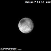
 Senior Member Group: Admin Posts: 4763 Joined: 15-March 05 From: Glendale, AZ Member No.: 197 |
QUOTE (Phil Stooke @ Jul 13 2015, 09:46 AM) Just playing with contrast in the brighter areas of Pluto and the terminators to make details easier to see. Certainly no doubt about the Copernican-looking impact crater on Charon from these latest images, clearly formed rays and all. -------------------- If Occam had heard my theory, things would be very different now.
|
|
|
|
|
Jul 13 2015, 07:22 PM
Post
#86
|
||
 Newbie Group: Members Posts: 15 Joined: 22-December 13 From: Newport Member No.: 7077 |
QUOTE (Phil Stooke @ Jul 13 2015, 06:46 PM) Just playing with contrast in the brighter areas of Pluto and the terminators to make details easier to see. Phil
Thanks Phil. I can't help but now see Charon's large, dark patch as an impact basin with that 'outer ring' in your processed image. Conjecture I know, but still... 
-------------------- There are 10 types of people in this world... those who understand binary and those who don't.
|
|
|
|
|
|
|
Jul 13 2015, 07:37 PM
Post
#87
|
|
|
Junior Member Group: Members Posts: 71 Joined: 3-February 11 Member No.: 5800 |
Less than 500,000 miles to closest approach, according to Eyes on the Solar System.
|
|
|
|
|
Jul 13 2015, 07:41 PM
Post
#88
|
|
|
Member Group: Members Posts: 153 Joined: 20-December 14 From: Eastbourne, UK Member No.: 7372 |
I am struck by how similar the topology is within the dark areas to that in the bright basin further north. They look "dunish", but the scale suggests, hills and ridges. The majority of the surface seems to be a series of ridges and valleys looping around and the diagram posted sometime back for super volatile deposition matches this terrain. This leads me to think the colour is organics/dust deposited on the surface, maybe as suggested above in only a thin layer of millimetres.
On the latest Pluto image down at 5 O'clock there are three huge mountains, just to the left we can see the beginnings of another dark area which is surrounded by cliffs many kilometres high. On the left rim at the start of the heart plateau we can see a huge elevation change up to the bright plateau. On the edges of the heart plateau as it runs down into the basin again a sharp cliff marks the edge of the bright heart material and the lighter grey of a second step down to the flatter expanse of the temperate latitude basin. [admin edit] To Charon, the craters hinted at before are quite clear now. Also clear now is how much of a Plateau the Polar ice cap is. That big nick on the limb at about 1 O'Clock continues as a deep valley all the way around the polar cap and its far cliff can be seen at 11 to 12 O'Clock. More wildly it might be speculated that nick is evidence of a subduction zone around the polar cap. I still can't explain why the cap is so dark, how organics and dust could be preferentially deposited at the poles, other than they would be a "cold spot" for concentrating any freezing volatiles. This implies Charon has or once had a significant atmosphere, either its own or what it has pulled off Pluto. It may not have large numbers of craters, but it appears to be a gnarly and very rugged world. |
|
|
|
|
Jul 13 2015, 07:46 PM
Post
#89
|
|
|
Junior Member Group: Members Posts: 66 Joined: 26-May 06 Member No.: 790 |
So exciting...!
Curious about something: I'm looking at Bill Harris' post on the hi-res coverage http://www.unmannedspaceflight.com/index.php?showtopic=8047&view=findpost&p=223020 (quick link to image here: hires coverage preview ). The long diagonal path of the highest resolution pictures (which I believe we won't see until the Fall) appears to run "off" the illuminated portion of Pluto just as it gets to the dark southeast edge of the "heart" (see the map at the top of the image). Does that mean that that part of the surface will be in darkness when the images are taken? If so, what is the anticipated result? Or is that just a byproduct of the available rough Pluto image with the correct orientation? I've seen the discussions of resolution constraints on the Charon-shine pictures to be taken after closest approach, but this would be a different beast, yes? |
|
|
|
|
Jul 13 2015, 07:56 PM
Post
#90
|
|
|
Junior Member Group: Members Posts: 88 Joined: 8-May 14 Member No.: 7185 |
The New Horizon team was quoted in a tweet as saying that there are signs of "frost transport" in the images coming down. Something like this is probably responsible for the various surface features we now see on Pluto, as predicted earlier: "Occultation studies have shown that there has been a steady increase in Pluto's atmospheric pressure over the past two decades, so concomitant sublimation and recondensation of frost has likely occurred, as predicted by volatile transport models." http://adsabs.harvard.edu/abs/2014EGUGA..16.4595B
|
|
|
|
|
Jul 13 2015, 08:04 PM
Post
#91
|
|
|
Member Group: Members Posts: 423 Joined: 13-November 14 From: Norway Member No.: 7310 |
I am starting to wonder if Charon has some Triton-esque terrain, too. Take a look..
  Not much solid evidence for many well-preserved impact craters, which is interesting. [admin edit] -------------------- |
|
|
|
|
Jul 13 2015, 08:19 PM
Post
#92
|
|
|
Member Group: Members Posts: 153 Joined: 20-December 14 From: Eastbourne, UK Member No.: 7372 |
Agree. Only evidence for a few really big ones. That may be resolution or the smaller ones have been covered over or changed by resurfacing events.
|
|
|
|
|
Jul 13 2015, 08:31 PM
Post
#93
|
|
|
Junior Member Group: Members Posts: 48 Joined: 10-September 06 Member No.: 1129 |
Charon does look like a Uranian moon from this resolution. We already know it's similar in size and density as well. It would be wonderful if closeup images of Charon tell us more about them.
|
|
|
|
|
Jul 13 2015, 08:48 PM
Post
#94
|
|
|
Member Group: Members Posts: 153 Joined: 20-December 14 From: Eastbourne, UK Member No.: 7372 |
Just looked at the latest Charon image again and that "crater" at 6-7 O'Clock appears to me to have a plume of darker material in the direction of the limb and a generous observer might say a smoke trail similar to a volcano can be seen. Impact crater or Caldera, the old question when looking at lower resolution images, even higher ones from Ceres are not conclusive. While in such an extravagantly, unfounded, speculative vein, the vast long Chasm running from 4 to 6 O'Clock, a rift valley? Are there, or were there, continents of Water Ice moving on a mantle of slush made up of super volatiles. At this point Charon is turning out to be a real conundrum. Pluto seems to fit the favoured theoretical models quite nicely, nobody seems to have a good handle on what's going on at Charon.
|
|
|
|
|
Jul 13 2015, 08:52 PM
Post
#95
|
|
|
Lord Of The Uranian Rings Group: Members Posts: 798 Joined: 18-July 05 From: Plymouth, UK Member No.: 437 |
I think Charon's going to be the biggest surprise from this flyby. I may be wrong, but perhaps we're looking at an icy version of Io here.
-------------------- |
|
|
|
|
Jul 13 2015, 09:12 PM
Post
#96
|
|
|
Member Group: Members Posts: 153 Joined: 20-December 14 From: Eastbourne, UK Member No.: 7372 |
QUOTE (Ian R @ Jul 13 2015, 09:52 PM) I think Charon's going to be the biggest surprise from this flyby. I may be wrong, but perhaps we're looking at an icy version of Io here. It may not be now, but before the two bodies became tidally locked, that is plausible I suppose. That might mean that what look like impact craters on Pluto might be ancient Calderas. especially the big circular features we saw on the Charon facing face a couple of days ago. EDIT: It might also explain why Charon is so uniformly "coloured" and the darkness of the polar cap. |
|
|
|
|
Jul 13 2015, 09:18 PM
Post
#97
|
|
|
IMG to PNG GOD Group: Moderator Posts: 2251 Joined: 19-February 04 From: Near fire and ice Member No.: 38 |
Charon looks somewhat similar to Uranus' moons, at least at this resolution. The chasm seems comparable to features seen on Ariel and Titania.
QUOTE (Sherbert @ Jul 13 2015, 08:48 PM) Just looked at the latest Charon image again and that "crater" at 6-7 O'Clock appears to me to have a plume of darker material in the direction of the limb I can't see anything plume-like anywhere. Meanwhile, on Pluto in the latest image (the one obtained at a distance of 2.5 million km), some of the terrain in the lower half of the image and left of center (at approximately 7 o'clock where there are alternating patches of bright and darker terrain) is starting to remind me a bit of the weird looking terrain seen in hi-res images of Mars' polar regions ("Swiss cheese features") where sublimation is a significant process. The only problem is that the Martian features aren't big and wouldn't even be close to visibility at the resolution of the most recent NH Pluto image. |
|
|
|
|
Jul 13 2015, 09:19 PM
Post
#98
|
|||
|
Member Group: Members Posts: 808 Joined: 10-October 06 From: Maynard Mass USA Member No.: 1241 |
Its amazing what you can do when if you write scripts (and get out of work early!)
Here are the 2nd set of images from July 11, 2015
-------------------- CLA CLL
|
||
|
|
|
||
|
Jul 13 2015, 09:27 PM
Post
#99
|
||
|
IMG to PNG GOD Group: Moderator Posts: 2251 Joined: 19-February 04 From: Near fire and ice Member No.: 38 |
Here is yet another version of my map of Pluto, this time incorporating the recently released image that was obtained at a range of 2.5 million km (the one that can be found here at the NH website). Apparently it was obtained on 2015-07-12 at 08:46. As usual, longitude 0 is at the left edge of the map.
The map now has much better coverage of parts of the terrain that will be imaged at high resolution tomorrow, including the northeast half of the bright region near the center of the map. |
|
|
|
|
|
|
Jul 13 2015, 09:44 PM
Post
#100
|
|
|
Senior Member Group: Moderator Posts: 3233 Joined: 11-February 04 From: Tucson, AZ Member No.: 23 |
Thanks for that map. The bright terrains near the equator definitely look like the patchy ice cap margins we saw at Triton.
-------------------- &@^^!% Jim! I'm a geologist, not a physicist!
The Gish Bar Times - A Blog all about Jupiter's Moon Io |
|
|
|
 |

|
Lo-Fi Version | Time is now: 3rd June 2024 - 10:16 PM |
|
RULES AND GUIDELINES Please read the Forum Rules and Guidelines before posting. IMAGE COPYRIGHT |
OPINIONS AND MODERATION Opinions expressed on UnmannedSpaceflight.com are those of the individual posters and do not necessarily reflect the opinions of UnmannedSpaceflight.com or The Planetary Society. The all-volunteer UnmannedSpaceflight.com moderation team is wholly independent of The Planetary Society. The Planetary Society has no influence over decisions made by the UnmannedSpaceflight.com moderators. |
SUPPORT THE FORUM Unmannedspaceflight.com is funded by the Planetary Society. Please consider supporting our work and many other projects by donating to the Society or becoming a member. |
|