Perseverance Route Map |

Perseverance Route Map |
 Feb 22 2021, 10:16 PM Feb 22 2021, 10:16 PM
Post
#1
|
||
|
Solar System Cartographer  Group: Members Posts: 10229 Joined: 5-April 05 From: Canada Member No.: 227 |
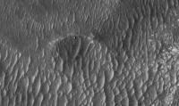
Now we are down safely I am starting a map thread. Everything that happens during 2021 will be covered in my still-in-progress atlas, so I have to make the maps for that and everyone can follow as they evolve.
Let me know if any feature names start to show up. Preliminary map even though not much has happened yet. But if you look closely you will see something, even now. Phil
-------------------- ... because the Solar System ain't gonna map itself.
Also to be found posting similar content on https://mastodon.social/@PhilStooke Maps for download (free PDF: https://upload.wikimedia.org/wikipedia/comm...Cartography.pdf NOTE: everything created by me which I post on UMSF is considered to be in the public domain (NOT CC, public domain) |
|
 |
 
|
|
 |
|
Feb 23 2021, 09:11 AM
Post
#2
|
|
 Member Group: Members Posts: 559 Joined: 1-May 06 From: Scotland (Ecosse, Escocia) Member No.: 759 |
Lovely stuff, Phil.
Are we seeing evidence of the rock pavement being cleared of dust by the descent engines, to the NE and SW? And conversely dark streaks towards the NW and SE ? A very minor observation is that because the gridlines intersect in the middle of Perseverance (as they should), we can't clearly see your lovely little rover symbol! Looking forward to seeing some white lines appearing soon.... Thanks again. |
|
|
|
|
Feb 23 2021, 04:39 PM
Post
#3
|
|
|
Member Group: Members Posts: 311 Joined: 31-August 05 From: Florida & Texas, USA Member No.: 482 |
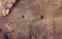
excellent! There's a white blob in the sand-filled crater 1 click SW of the rover. Seems strange for a large boulder to be there, so is that somehow part of the EDL?
|
|
|
|
|
Feb 23 2021, 05:04 PM
Post
#4
|
||
|
Founder Group: Chairman Posts: 14434 Joined: 8-February 04 Member No.: 1 |
Easy test - go find the location in this map. If it's in this map - it's pre-EDL - it's just natural.
You don't mean this by any chance? This is pre-landing.
Attached thumbnail(s)
|
|
|
|
|
|
|
Mar 3 2021, 04:37 AM
Post
#5
|
|
|
Member Group: Members Posts: 248 Joined: 25-February 21 From: Waltham, Massachussetts, U.S.A. Member No.: 8974 |
Following up on registering as accurately as possible a well suited rover downlook map image I thought it may be useful to easily look up coordinates and measure distances on the map. Here is a bare bones web app (takes a bit to load) to do that:
http://bit.ly/PercyMAP with reduced texture for mobile http://bit.ly/PercyMAPm It is made using https://www.x3dom.org/ and a little javascript. One can zoom in (wheel or right mouse drag), pan (middle mouse drag) and re-center (double left click). The coordinates of the cross-hair are reported and left clicking adds the current position to a list, and calculates the distance from the last recorded point. For example, it turns out that the wind-carved walrus boulder (harbour seal) is about 12m away from the rover. The used HiRISE DEM has nominally a 1m resolution but seems smoother than that in places, perhaps not picking up all boulders. I may add a few additional features (controlling shading, continuous reporting of distance to rover) but nothing fancy to keep it really simple. [edit] There is now a slider to control vertical exaggeration of the elevation model. -------------------- --
Andreas Plesch, andreasplesch at gmail dot com |
|
|
|
|
Mar 5 2021, 10:15 PM
Post
#6
|
||
|
Solar System Cartographer Group: Members Posts: 10229 Joined: 5-April 05 From: Canada Member No.: 227 |
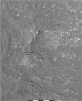
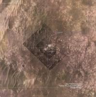
OK, first drive, first map. It's a close-up, not the overview provided by the first one I posted, which I will come back to as we move more.
This map uses HiRISE for geometric control, with descent images registered to that for more detail, and the first panorama projected out over that. Phil
-------------------- ... because the Solar System ain't gonna map itself.
Also to be found posting similar content on https://mastodon.social/@PhilStooke Maps for download (free PDF: https://upload.wikimedia.org/wikipedia/comm...Cartography.pdf NOTE: everything created by me which I post on UMSF is considered to be in the public domain (NOT CC, public domain) |
|
|
|
|
|
|
Mar 5 2021, 10:51 PM
Post
#7
|
|
|
Member Group: Members Posts: 808 Joined: 10-October 06 From: Maynard Mass USA Member No.: 1241 |
... and so it begins... surprise us!
-------------------- CLA CLL
|
|
|
|
|
Mar 6 2021, 08:51 PM
Post
#8
|
||
|
Solar System Cartographer Group: Members Posts: 10229 Joined: 5-April 05 From: Canada Member No.: 227 |
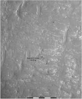
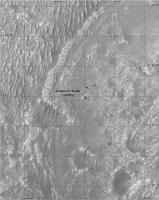
OK, it did surprise me. We are outside my base map on sol 15, so here is a new map for this drive. That's the problem when you are mapping in real time! Fully prepared to have to switch map bases again tomorrow - that will be back to the first one I posted, most likely.
You may notice that my route is offset a few meters from the one on the interactive map on the mission website - they start a bit too close to the drift behind the rover at landing, and the whole path and each site retains that offset. My site locations are based on hazcam images. Phil
-------------------- ... because the Solar System ain't gonna map itself.
Also to be found posting similar content on https://mastodon.social/@PhilStooke Maps for download (free PDF: https://upload.wikimedia.org/wikipedia/comm...Cartography.pdf NOTE: everything created by me which I post on UMSF is considered to be in the public domain (NOT CC, public domain) |
|
|
|
|
|
|
Mar 6 2021, 10:14 PM
Post
#9
|
|
|
Member Group: Members Posts: 248 Joined: 25-February 21 From: Waltham, Massachussetts, U.S.A. Member No.: 8974 |
I had noticed that offset as well. It seems to me that somehow their rover position to base map registration is a little off.
Looking at the network traffic on https://mars.nasa.gov/mars2020/mission/where-is-the-rover/, it turns out that the traverse and waypoints are plotted with a geojson file. traverse: https://mars.nasa.gov/mmgis-maps/M20/Layers...0_traverse.json waypoints: https://mars.nasa.gov/mmgis-maps/M20/Layers..._waypoints.json The geojson has the actual coordinates, and one can use it directly for mapping:  The traverse is given by small multiple segments, shown as the grey points. The red waypoints have additional rover orientation data, yaw, pitch and roll. yaw is shown on the map. https://mars.nasa.gov/maps/location/api/con...get?mission=M20 is the overall layer configuration. It has the urls of the geojson geometries. It seem that the web site uses a terrestrial CRS (WGS84) for plotting. Perhaps the rover coordinates are actually for a Mars CRS. That may explain that slight offset depending on the base map projection. -------------------- --
Andreas Plesch, andreasplesch at gmail dot com |
|
|
|
|
Mar 7 2021, 12:59 PM
Post
#10
|
||
 Member Group: Members Posts: 349 Joined: 20-June 07 From: Slovenia Member No.: 2461 |
My take at the landing map and first drives. It uses combination of Rover Descent Camera footage combined with HiRise image of Perserverance on the ground. Descent stage exhaust marks are also clearly visible. The geoJSON files are indeed projected to WGS84 datum, so you only need to change that to Mars projection (both sphere and MOLA work) for the track to align in the right place. The new interface also offers geoJSON updates for Curiosity's position. |
|
|
|
|
|
|
Mar 7 2021, 01:06 PM
Post
#11
|
||
|
Member Group: Members Posts: 349 Joined: 20-June 07 From: Slovenia Member No.: 2461 |
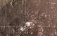
Another take at the Perseverance's landing map, with all the hardware location marked. Blue line is EDL track from SPICE kernels (looks like a pre-landing solution). It's curious that the rover landed less than km from 2018 landing ellipse center. |
|
|
|
|
|
|
Mar 7 2021, 02:48 PM
Post
#12
|
||
|
Member Group: Members Posts: 349 Joined: 20-June 07 From: Slovenia Member No.: 2461 |
It's already time to update...sol 16
|
|
|
|
|
|
|
Mar 7 2021, 03:23 PM
Post
#13
|
|
|
Member Group: Members Posts: 248 Joined: 25-February 21 From: Waltham, Massachussetts, U.S.A. Member No.: 8974 |
And here is my take:
 I am assigning CRS ESRI:104971 - Mars_2000_(Sphere) - Geographic to the geojson coordinates, and use the equirectangular projection for plotting which is native to the HiRISE mosaic. The arrows show the yaw orientation at the way points. The little circles along the path are where positions are actually provided in the traverse geojson. We are getting outside the range of the EDL Rover Downlook imagery. Perhaps it is worth looking through those again to see if there is one covering the new terrain in higher detail than the 25cm HiRISE mosaic. -------------------- --
Andreas Plesch, andreasplesch at gmail dot com |
|
|
|
|
Mar 7 2021, 07:10 PM
Post
#14
|
||
|
Solar System Cartographer Group: Members Posts: 10229 Joined: 5-April 05 From: Canada Member No.: 227 |
Map updated to sol 16. I hope for some feature names to add to it, eventually. I will have to re-think my earlier maps a bit. The sol 16 site is just a tiny bit outside the edge of the last map so I can probably adjust it.
It's great to see these alternative views of the traverse here. Phil
-------------------- ... because the Solar System ain't gonna map itself.
Also to be found posting similar content on https://mastodon.social/@PhilStooke Maps for download (free PDF: https://upload.wikimedia.org/wikipedia/comm...Cartography.pdf NOTE: everything created by me which I post on UMSF is considered to be in the public domain (NOT CC, public domain) |
|
|
|
|
|
|
Mar 7 2021, 07:26 PM
Post
#15
|
|
|
Member Group: Members Posts: 363 Joined: 13-April 06 From: Malta Member No.: 741 |
Dont know if its the correct site to post this but looking at the orbital view, the rock pavement next to where the rover is sitting right now looks morelike sedimentary to me rather than a lava field and yet i am no geologist so who knows.
|
|
|
|
 |

|
Lo-Fi Version | Time is now: 26th September 2024 - 01:28 PM |
|
RULES AND GUIDELINES Please read the Forum Rules and Guidelines before posting. IMAGE COPYRIGHT |
OPINIONS AND MODERATION Opinions expressed on UnmannedSpaceflight.com are those of the individual posters and do not necessarily reflect the opinions of UnmannedSpaceflight.com or The Planetary Society. The all-volunteer UnmannedSpaceflight.com moderation team is wholly independent of The Planetary Society. The Planetary Society has no influence over decisions made by the UnmannedSpaceflight.com moderators. |
SUPPORT THE FORUM Unmannedspaceflight.com is funded by the Planetary Society. Please consider supporting our work and many other projects by donating to the Society or becoming a member. |
|