Cape York - The "Lakelands", Starting sol 2703 |

Cape York - The "Lakelands", Starting sol 2703 |
 Sep 1 2011, 04:30 PM Sep 1 2011, 04:30 PM
Post
#1
|
|
|
Senior Member  Group: Moderator Posts: 4279 Joined: 19-April 05 From: .br at .es Member No.: 253 |
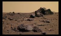
Bye bye, Tisdale. It's time to move on.
Next target? Philosilicates. ----- Edited on Sep 16 2011. This thread is dedicated to the exploration of Cape York, starting on sol 2703 when Opportunity left the "rocky garden" and started moving towards Chester Lake. |
 |
 
|
 |
|
Sep 2 2011, 08:27 AM
Post
#2
|
||
|
Senior Member Group: Members Posts: 2837 Joined: 22-April 05 From: Ridderkerk, Netherlands Member No.: 353 |
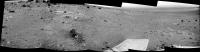
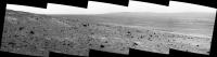
The Navcam L0 view on Sol 2703.
Jan van Driel
|
|
|
|
|
|
|
Sep 2 2011, 11:01 AM
Post
#3
|
|
|
Senior Member Group: Moderator Posts: 4279 Joined: 19-April 05 From: .br at .es Member No.: 253 |
As soon as we move to the east edge of CY, I think the view to Endeavour's far side and the north rim will improve significantly.
|
|
|
|
|
Sep 3 2011, 01:43 AM
Post
#4
|
|
 Senior Member Group: Moderator Posts: 3431 Joined: 11-August 04 From: USA Member No.: 98 |
Sol 2703-2704 Navcam panorama (updated)
  
|
|
|
|
|
Sep 3 2011, 09:05 AM
Post
#5
|
|
|
Senior Member Group: Moderator Posts: 4279 Joined: 19-April 05 From: .br at .es Member No.: 253 |
I just finished reading this month's MER Report (by Salley Rayl @ TPS); a great reading with a lot of goodies, as usual. I'm copying here a reference about our next waypoint:
QUOTE Opportunitys next immediate destination is an outcrop on the southern brow of Cape York, located, as Nelson described it, "roughly 30 meters (98.42 feet) north of Spirit Point or the area of the southern tip of Cape York, and roughly 45 to 50 meters (131.23 to 164.04 feet) east of Tisdale 2." QUOTE (walfy @ Sep 3 2011, 09:02 AM)  Another type of gif animation of Tisdale 2: A really rough surface, isn't it? Easy to understand why they didn't use the RAT on it. |
|
|
|
|
Sep 3 2011, 06:23 PM
Post
#6
|
|
 Senior Member Group: Members Posts: 4252 Joined: 17-January 05 Member No.: 152 |
QUOTE (Tesheiner @ Sep 3 2011, 10:05 AM) I just finished reading this month's MER Report Some good quotes about the future in that update: QUOTE "Cape Tribulation has an extensive exposure mineralogically of smectite, which typically forms in presence of water sitting on basalt. But it's a couple kilometers to south and the rover would have to climb an 80-meter hill, and then drive down a 25 degree slope to get to it," Arvidson explained. QUOTE "The plan beyond is to really look at those hills to the south that's real mountain climbing," said Hartman. "Cape York is much more manageable, more weathered, more eroded, and there are some indications phyllosilicates are here, so we're going to sniff around here and see if we can find them, but the longer-term plan is to attack Cape Tribulation. That's going to be a whole other kettle of fish for us. From Squyres: QUOTE Having said that, Cape Tribulation is the obvious next place to go for after we've really done our job at Cape York. So we're going to do the best that we can here. Then we're going to see what kind of a rover we've got and we're going to do the best we can with it. Are we going to Cape Tribulation or not? Don't know. I hope so. It looks pretty cool."
|
|
|
|
|
Sep 4 2011, 10:21 PM
Post
#7
|
||||
 The Poet Dude Group: Moderator Posts: 5551 Joined: 15-March 04 From: Kendal, Cumbria, UK Member No.: 60 |
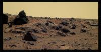
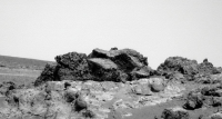
Some goodies from today...
Drive direction?
Rather yummy-looking outcrop/ridge?
A(nother) beaten up breccia of a mongrel of a rock... -------------------- |
|||
|
|
|
|||
|
Sep 5 2011, 02:37 AM
Post
#8
|
|
|
Senior Member Group: Moderator Posts: 3431 Joined: 11-August 04 From: USA Member No.: 98 |
QUOTE (Stu @ Sep 4 2011, 03:21 PM) Some goodies from today... In order, labels are: "HBC" (whatever that means; maybe "B" is for Bedrock?), "Kirkland Lake", and "Marion". In the second one I assume "Kirkland Lake" is the largest feature. We've seen it from the side. The triangularish rock on the left in that one must be "Trailbreaker", then, I guess. (As Tesheiner figured. Of course, keep in mind this is still partly guesswork.) |
|
|
|
|
Sep 5 2011, 02:58 AM
Post
#9
|
|
|
Solar System Cartographer Group: Members Posts: 10190 Joined: 5-April 05 From: Canada Member No.: 227 |
To any Canadian, HBC can only mean Hudson's Bay Company... though maybe to a MER driver it means something different... did Oppy lose a hubcap?
Phil -------------------- ... because the Solar System ain't gonna map itself.
Also to be found posting similar content on https://mastodon.social/@PhilStooke Maps for download (free PD: https://upload.wikimedia.org/wikipedia/comm...Cartography.pdf NOTE: everything created by me which I post on UMSF is considered to be in the public domain (NOT CC, public domain) |
|
|
|
| Guest_Sunspot_* |
Sep 5 2011, 06:10 AM
Post
#10
|
|
Guests |
So what might these 3 plus billion year old clay deposits actually look like to Opportunity's cameras? Are they likely to be dramatically obvious or very subtle perhaps indistinguishable from their surroundings?
|
|
|
|
|
Sep 5 2011, 02:24 PM
Post
#11
|
|
|
Senior Member Group: Moderator Posts: 3431 Joined: 11-August 04 From: USA Member No.: 98 |
|
|
|
|
|
Sep 5 2011, 06:08 PM
Post
#12
|
|
|
Senior Member Group: Moderator Posts: 4279 Joined: 19-April 05 From: .br at .es Member No.: 253 |
QUOTE (mhoward @ Sep 5 2011, 04:24 PM) Definitely yes! Looking at Tisdale 1 from this perspective I think it's almost clear it has the same "bright top" as Tisdale 2. There were some pancams of it planned to be taken thisol (2707) and I believe those shots should confirm it. Would like to know the meaning of "HBC" too; I presume it is related to the bright patch of bedrock to the right of those three rocks. Actually, the rover moved to that area some hours ago. Map update in a minute. |
|
|
|
|
Sep 5 2011, 07:45 PM
Post
#13
|
|
 Senior Member Group: Moderator Posts: 2262 Joined: 9-February 04 From: Melbourne - Oz Member No.: 16 |
Here is the HBC mosaic:
 -------------------- |
|
|
|
|
Sep 5 2011, 08:06 PM
Post
#14
|
|
 Senior Member Group: Members Posts: 3648 Joined: 1-October 05 From: Croatia Member No.: 523 |
Nice!
-------------------- |
|
|
|
|
Sep 5 2011, 08:21 PM
Post
#15
|
|
|
Senior Member Group: Moderator Posts: 3431 Joined: 11-August 04 From: USA Member No.: 98 |
|
|
|
|
|
Sep 6 2011, 01:30 AM
Post
#16
|
||
|
Junior Member Group: Members Posts: 54 Joined: 10-August 11 Member No.: 6119 |
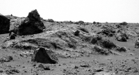
'Kirkland Lake' from the south,
pancam flicker gif, sol 2706
|
|
|
|
|
|
|
Sep 6 2011, 03:54 PM
Post
#17
|
|
|
Member Group: Members Posts: 507 Joined: 10-September 08 Member No.: 4338 |
QUOTE (Sunspot @ Sep 4 2011, 11:10 PM) So what might these 3 plus billion year old clay deposits actually look like to Opportunity's cameras? Are they likely to be dramatically obvious ...? I'm thinking that without the mini-tes, it might be difficult to distinguish them. Now the loss of the MTES starts to hurt. |
|
|
|
|
Sep 6 2011, 10:16 PM
Post
#18
|
||
|
The Poet Dude Group: Moderator Posts: 5551 Joined: 15-March 04 From: Kendal, Cumbria, UK Member No.: 60 |
Ooh, pretty view...
-------------------- |
|
|
|
|
|
|
Sep 8 2011, 02:57 AM
Post
#19
|
|
|
Senior Member Group: Members Posts: 4252 Joined: 17-January 05 Member No.: 152 |
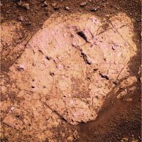
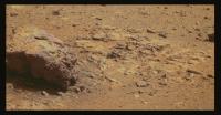
I love the crazy lustre of the bedrock in the latest pancams - Chester Lake perhaps?
http://qt.exploratorium.edu/mars/opportuni...7M1.JPG?sol2709 How much information does the lustre give the geologically minded here about the rock? Can't wait to see this in colour... |
|
|
|
|
Sep 8 2011, 03:47 AM
Post
#20
|
|
|
Member Group: Members Posts: 706 Joined: 22-April 05 Member No.: 351 |
I think it's going to awhile before the geologists get tired of this place
-------------------- |
|
|
|
|
Sep 8 2011, 04:00 AM
Post
#21
|
||
 Member Group: Members Posts: 107 Joined: 29-January 09 Member No.: 4589 |
fredk's "Chester Lake" L2-5-7 pancams. Others can undoubtedly do better

-------------------- Protein structures and Mars fun - http://www.flickr.com/photos/nick960/
|
|
|
|
|
|
|
Sep 8 2011, 06:01 AM
Post
#22
|
|
 Member Group: Members Posts: 754 Joined: 9-February 07 Member No.: 1700 |
I continue to be stunned and amazed, not only at the imagery coming from Oppy, but the gorgeous processing y'alls are doing. Thank you so many times!
|
|
|
|
|
Sep 8 2011, 02:11 PM
Post
#23
|
||
|
The Poet Dude Group: Moderator Posts: 5551 Joined: 15-March 04 From: Kendal, Cumbria, UK Member No.: 60 |
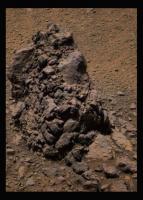
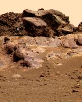
"Chester Lake" looks very interesting. Ridges of harder, darker rock jutting up out of lighter rock... cracks... pits... it's got it all...
(sharpened and colour-enhanced to bring out subtle features on the rock) Full size version: http://roadtoendeavour.files.wordpress.com/2011/09/v2.jpg -------------------- |
|
|
|
|
|
|
Sep 8 2011, 02:49 PM
Post
#24
|
|
|
Senior Member Group: Members Posts: 3516 Joined: 4-November 05 From: North Wales Member No.: 542 |
Some of the shiny bits do look like knobbly inclusions of a harder material, but others look like flat quadrilaterals bounded by
the surface crack patterns, as if they could be places where thin flakes of weathered surface material have recently broken away. I wonder if any of the loose flakes lying around the vicinity can be matched up shape-wise to individual shiny patches on the rock? |
|
|
|
|
Sep 8 2011, 10:13 PM
Post
#25
|
|
|
Senior Member Group: Moderator Posts: 2262 Joined: 9-February 04 From: Melbourne - Oz Member No.: 16 |
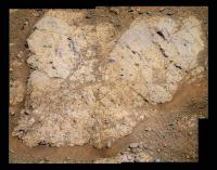
Chester Lake in 'false but trying' and 'stretched to within an inch' colours.
  Fascinating... -------------------- |
|
|
|
|
Sep 8 2011, 11:47 PM
Post
#26
|
||
 Member Group: Members Posts: 404 Joined: 5-January 10 Member No.: 5161 |
Right side of Chester Lake:
|
|
|
|
|
|
|
Sep 9 2011, 12:00 AM
Post
#27
|
||
|
Member Group: Members Posts: 404 Joined: 5-January 10 Member No.: 5161 |
Left side of Chester Lake:
|
|
|
|
|
|
|
Sep 9 2011, 03:40 PM
Post
#28
|
|
|
Senior Member Group: Moderator Posts: 3431 Joined: 11-August 04 From: USA Member No.: 98 |
|
|
|
|
|
Sep 9 2011, 05:18 PM
Post
#29
|
|||
|
Senior Member Group: Moderator Posts: 3431 Joined: 11-August 04 From: USA Member No.: 98 |
Just for fun
Attached thumbnail(s)
|
||
|
|
|
||
|
Sep 9 2011, 07:22 PM
Post
#30
|
|
|
Senior Member Group: Members Posts: 3516 Joined: 4-November 05 From: North Wales Member No.: 542 |
QUOTE (mhoward @ Sep 9 2011, 04:40 PM) Sol 2710 Navcam panorama That's so much better than my paper version, thanks! And while I'm at it huge thanks to everyone for all the wonderful rockscapes and Endeavour vistas on this thread. |
|
|
|
|
Sep 10 2011, 02:02 AM
Post
#31
|
||
|
Solar System Cartographer Group: Members Posts: 10190 Joined: 5-April 05 From: Canada Member No.: 227 |
A circular version of mhoward's nice new panorama.
Phil
-------------------- ... because the Solar System ain't gonna map itself.
Also to be found posting similar content on https://mastodon.social/@PhilStooke Maps for download (free PD: https://upload.wikimedia.org/wikipedia/comm...Cartography.pdf NOTE: everything created by me which I post on UMSF is considered to be in the public domain (NOT CC, public domain) |
|
|
|
|
|
|
Sep 10 2011, 05:23 AM
Post
#32
|
|
 Senior Member Group: Members Posts: 2492 Joined: 15-January 05 From: center Italy Member No.: 150 |
Marvellous, guys! Starts to recall me Spirit Odyssey on Husband hill!
-------------------- I always think before posting! - Marco -
|
|
|
|
|
Sep 10 2011, 12:08 PM
Post
#33
|
||
|
Senior Member Group: Members Posts: 2837 Joined: 22-April 05 From: Ridderkerk, Netherlands Member No.: 353 |
Another Navcam L0 view taken on Sol 2710.
Jan van Driel
|
|
|
|
|
|
|
Sep 10 2011, 03:09 PM
Post
#34
|
|
|
Senior Member Group: Members Posts: 4252 Joined: 17-January 05 Member No.: 152 |
Some comments on Chester Lake (and a false colour (?!) pancam view) here. "Paraphrased" from Squyres:
QUOTE The new target should be IDD'd... it looks bright and Noachian itself... Need to build a nice story here and relate it to the Tisdales... We think there might be a coating, so we'll have to choose a target carefully and at least APXS it... Consider RAT'ing it to get into its guts... I wonder what about it "looks Noachian"...
It is something entirely new, or SOS ("Same Old Sulfates")? This is our first major Noachian target, so let's make it count. |
|
|
|
|
Sep 10 2011, 04:12 PM
Post
#35
|
|
|
Junior Member Group: Members Posts: 98 Joined: 17-July 11 From: Pasadena, CA Member No.: 6066 |
QUOTE (fredk @ Sep 10 2011, 07:09 AM) Some comments on Chester Lake (and a false colour (?!) pancam view) here. "Paraphrased" from Squyres:I wonder what about it "looks Noachian"... Had me fooled, too. I asked myself that all day. The EOSs and SOWG meetings are particularly cryptic these days; these guys talk and head and shoulders above my comprehension! -m |
|
|
|
|
Sep 10 2011, 05:50 PM
Post
#36
|
|
|
Member Group: Members Posts: 507 Joined: 10-September 08 Member No.: 4338 |
Maybe it is the orbital images of that locality that look Noachian rather than that specific rock.
|
|
|
|
|
Sep 10 2011, 06:45 PM
Post
#37
|
|
|
Solar System Cartographer Group: Members Posts: 10190 Joined: 5-April 05 From: Canada Member No.: 227 |
The new target is Salisbury... my home town! - I mean the one in Wiltshire, not one of the Salisburys in the colonies.
Phil -------------------- ... because the Solar System ain't gonna map itself.
Also to be found posting similar content on https://mastodon.social/@PhilStooke Maps for download (free PD: https://upload.wikimedia.org/wikipedia/comm...Cartography.pdf NOTE: everything created by me which I post on UMSF is considered to be in the public domain (NOT CC, public domain) |
|
|
|
|
Sep 10 2011, 07:13 PM
Post
#38
|
|
|
The Poet Dude Group: Moderator Posts: 5551 Joined: 15-March 04 From: Kendal, Cumbria, UK Member No.: 60 |
-------------------- |
|
|
|
|
Sep 11 2011, 01:22 AM
Post
#39
|
|
|
Senior Member Group: Members Posts: 1045 Joined: 17-February 09 Member No.: 4605 |
QUOTE (fredk @ Sep 10 2011, 04:09 PM) I wonder what about it "looks Noachian"... It looks like an impact breccia, integral to the weathered rim of a crater that pre-dated the Meridiani sediment formation. Could it be anything other than a Noachian construct? |
|
|
|
|
Sep 11 2011, 09:28 AM
Post
#40
|
|
|
Senior Member Group: Members Posts: 2998 Joined: 30-October 04 Member No.: 105 |
True that, Serpens. The geomorph of this area is more complex and convoluted than we we assume or possibly can imagine. It's like standing on a small chunk of the Canadian Shield and figuring out depositional environments with a handlens and a Brunton.
Ah, the comparative simplicity of seven years on the playa may have spoilt us... --Bill (almost giddy with anticipation over impending MI's and APXS) -------------------- |
|
|
|
|
Sep 11 2011, 03:37 PM
Post
#41
|
|
 Member Group: Members Posts: 267 Joined: 5-February 06 Member No.: 675 |
Could some of you tell a non-geologist what kinds of questions the new detail we're encountering might answer. What more will we learn about the history of Mars -- besides the overly mentioned issue of water.
Steve M |
|
|
|
|
Sep 11 2011, 06:11 PM
Post
#42
|
|
|
Solar System Cartographer Group: Members Posts: 10190 Joined: 5-April 05 From: Canada Member No.: 227 |
We don't know all the details, but it seems the sulfate and blueberry rocks of the plains we've just left were formed in a relatively brief period in the middle of Martian history. Water was there, and probably very salty and foul-tasting water! - not very pleasant for life. These rocks at Cape York are much older, and may have formed in very different conditions. What we hope to learn is, what were those conditions? Warm or cold? Reducing or oxidizing conditions? Acidic or alkaline? Lots of water or only a bit? Water in the ground, or melting out of overlying snow? So we would expect evidence of water, but it's the environmental conditions that are most important.
Phil -------------------- ... because the Solar System ain't gonna map itself.
Also to be found posting similar content on https://mastodon.social/@PhilStooke Maps for download (free PD: https://upload.wikimedia.org/wikipedia/comm...Cartography.pdf NOTE: everything created by me which I post on UMSF is considered to be in the public domain (NOT CC, public domain) |
|
|
|
|
Sep 11 2011, 08:57 PM
Post
#43
|
|
|
Senior Member Group: Members Posts: 2998 Joined: 30-October 04 Member No.: 105 |
That is it, exactly. When a rock like basalt weathers, in the presence of water, it breaks down into clay minerals (the phyllosilicates in the news) and various anions and cations ("minerals" dissolved in the water). The type of clays, and other weathering byproducts, is dependent on the ionic makeup of the water to begin with, as well as the temperature and whether the environment was oxidizing or reducing. By looking at the weathered zone on the hill, we can tell what the conditions were way back then.
--Bill -------------------- |
|
|
|
|
Sep 11 2011, 09:29 PM
Post
#44
|
|
|
The Poet Dude Group: Moderator Posts: 5551 Joined: 15-March 04 From: Kendal, Cumbria, UK Member No.: 60 |
Thanks Bill and Phil, that's a really clear, really useful explanation of the significance of this place. Much appreciated.
-------------------- |
|
|
|
|
Sep 11 2011, 10:00 PM
Post
#45
|
|
|
Senior Member Group: Members Posts: 3516 Joined: 4-November 05 From: North Wales Member No.: 542 |
There is the complication of deciding whether any clays that may be found were formed by weathering of the basalts before the impact or after brecciation and deposition on the crater rim. It's not an easy puzzle.
|
|
|
|
|
Sep 12 2011, 01:05 AM
Post
#46
|
||
|
Junior Member Group: Members Posts: 54 Joined: 10-August 11 Member No.: 6119 |
Stoughton and Ridout,
flicker gif pancam sol 2711...
|
|
|
|
|
|
|
Sep 12 2011, 08:40 AM
Post
#47
|
|
|
Senior Member Group: Members Posts: 2837 Joined: 22-April 05 From: Ridderkerk, Netherlands Member No.: 353 |
Thanks Phil and Bill for that explanation and SteveM for the question.
Now I, as a non-geologist, understand what is going on on Mars besides driving and taking pictures and measurements. That is the purpose of this website, or not ?. jan van Driel |
|
|
|
|
Sep 12 2011, 02:49 PM
Post
#48
|
|
|
Member Group: Members Posts: 293 Joined: 22-September 08 From: Spain Member No.: 4350 |
QUOTE (Stu @ Sep 12 2011, 01:30 PM) That pancam caught a dark embedded pebble in the lower left. |
|
|
|
|
Sep 12 2011, 03:59 PM
Post
#49
|
|
|
Member Group: Members Posts: 913 Joined: 4-September 06 From: Boston Member No.: 1102 |
QUOTE (Fran Ontanaya @ Sep 12 2011, 10:49 AM) That pancam caught a dark embedded pebble in the lower left. Can anyone place the background of this image. Where is it relative to Chester Lake? Is it in one of the pancam or navcam panoramas? -------------------- |
|
|
|
|
Sep 12 2011, 05:19 PM
Post
#50
|
||
|
Senior Member Group: Moderator Posts: 4279 Joined: 19-April 05 From: .br at .es Member No.: 253 |
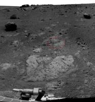
It's above it. The latest navcam mosaic (from sol 2710) misses the peeble by just a few cm or so but the one taken at the previous site, before the final approach to Chester Lake, catches it. I highlighted the peeble and the whole area on this partly mosaic from sol 2707.
|
|
|
|
|
|
|
Sep 12 2011, 05:38 PM
Post
#51
|
|
|
Senior Member Group: Moderator Posts: 3431 Joined: 11-August 04 From: USA Member No.: 98 |
Actually they took a left Navcam image at the same time as the color Pancam image, and it fits in with the Sol 2710 panorama.
 Full 360 degree panorama with single color image:  QuickTime VR version (5 MB) Edit: Improved the images a bit. |
|
|
|
|
Sep 12 2011, 07:17 PM
Post
#52
|
|
|
Member Group: Members Posts: 267 Joined: 5-February 06 Member No.: 675 |
Sorry I didn't get back earlier to thank Phil and Bill fore the helpful answers (doing some remodeling and those who've been there know what that does to free time).
Steve M |
|
|
|
|
Sep 13 2011, 10:42 AM
Post
#53
|
||||
|
The Poet Dude Group: Moderator Posts: 5551 Joined: 15-March 04 From: Kendal, Cumbria, UK Member No.: 60 |
"Brett Lake'...
"Larder Lake"...
"Kinojevis"
-------------------- |
|||
|
|
|
|||
|
Sep 13 2011, 02:03 PM
Post
#54
|
|
|
Senior Member Group: Moderator Posts: 3431 Joined: 11-August 04 From: USA Member No.: 98 |
Time once again to play where are the rocks (Sol 2710-2714). See Stu's post for names; the bottom one with the NASA logo is "Salisbury 1".
|
|
|
|
|
Sep 14 2011, 12:00 AM
Post
#55
|
|
 Member Group: Members Posts: 815 Joined: 3-June 04 From: Brittany, France Member No.: 79 |
QUOTE (Stu @ Sep 13 2011, 11:42 AM) "Brett Lake'... "Larder Lake"... "Kinojevis" Beautiful pics Stu ! Have Opportunity reached the first phyllosilicates rocks ? -------------------- |
|
|
|
|
Sep 15 2011, 05:02 AM
Post
#56
|
|
 Senior Member Group: Admin Posts: 3108 Joined: 21-December 05 From: Canberra, Australia Member No.: 615 |
As there were a lot of variations on the same image of Opportunity's IDD for 9/11, it was worth moving them all to their own thread.
NB: mhoward's panoramas which included the IDD shot were not moved as they incorporated the wider view of Oppy's current location. |
|
|
|
|
Sep 15 2011, 01:02 PM
Post
#57
|
||
|
Senior Member Group: Members Posts: 1074 Joined: 21-September 07 From: Québec, Canada Member No.: 3908 |
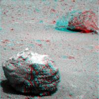
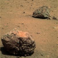
Nice pair of rocks (names?).
The one in front makes me think of a block of slag (just an impression, not very scientific, I know). |
|
|
|
|
|
|
Sep 15 2011, 02:14 PM
Post
#58
|
|
|
Senior Member Group: Moderator Posts: 3431 Joined: 11-August 04 From: USA Member No.: 98 |
QUOTE (charborob @ Sep 15 2011, 07:02 AM) Nice pair of rocks (names?). 'Biscotasing' and 'Halliday'. Unknown which is which, but I would guess from left to right. |
|
|
|
|
Sep 15 2011, 02:49 PM
Post
#59
|
||
|
Solar System Cartographer Group: Members Posts: 10190 Joined: 5-April 05 From: Canada Member No.: 227 |
A composite of the current pan plus names. I am finding it hard to go back to sites from years ago and recover the names used at the time - even the PDS interface to names is clumsy and incomplete. I would like to encourage our merry band to continue to document names as we have been doing here.
Phil
-------------------- ... because the Solar System ain't gonna map itself.
Also to be found posting similar content on https://mastodon.social/@PhilStooke Maps for download (free PD: https://upload.wikimedia.org/wikipedia/comm...Cartography.pdf NOTE: everything created by me which I post on UMSF is considered to be in the public domain (NOT CC, public domain) |
|
|
|
|
|
|
Sep 15 2011, 02:54 PM
Post
#60
|
|
|
Senior Member Group: Moderator Posts: 3431 Joined: 11-August 04 From: USA Member No.: 98 |
QUOTE (Phil Stooke @ Sep 15 2011, 07:49 AM) A composite of the current pan plus names. Good idea. I might have a go at that myself, later; it's kind of a relaxing hobby. If only I could easily get subframe images onto my panorama. |
|
|
|
|
Sep 15 2011, 05:53 PM
Post
#61
|
||
|
Member Group: Members Posts: 815 Joined: 3-June 04 From: Brittany, France Member No.: 79 |
Biscotasing and Halliday in color, on sol 2716.
Attached thumbnail(s)
-------------------- |
|
|
|
|
|
|
Sep 15 2011, 06:03 PM
Post
#62
|
||
|
Member Group: Members Posts: 815 Joined: 3-June 04 From: Brittany, France Member No.: 79 |
And Larder Lake, on sol 2715.
Attached thumbnail(s)
-------------------- |
|
|
|
|
|
|
Sep 15 2011, 06:49 PM
Post
#63
|
||
|
Member Group: Members Posts: 404 Joined: 5-January 10 Member No.: 5161 |
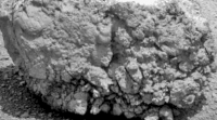
Biscotasing rock super gif:
|
|
|
|
|
|
| Guest_Sunspot_* |
Sep 15 2011, 09:06 PM
Post
#64
|
|
Guests |
It looks like it might fall apart if you touched it.....and it kind of looks like a meatball
|
|
|
|
|
Sep 15 2011, 10:23 PM
Post
#65
|
||
|
Junior Member Group: Members Posts: 54 Joined: 10-August 11 Member No.: 6119 |
Stoughton, sol 2716 L456
Interesting looking light-coloured rock embedded in that block of brecia. |
|
|
|
|
|
|
Sep 15 2011, 11:09 PM
Post
#66
|
|
|
Member Group: Members Posts: 184 Joined: 2-March 06 Member No.: 692 |
According to Scott Maxwell's Twitter site, the IDD will brush and APXS - mossbauer the site with a grind on friday. But later says their is a lively debate on getting on with moving.
If they use the limmited resource of the grind, I bet a mossbauer is likely. And with the time that would take would a large super pan or super res shot take place in light of the not so hot tau? Also the grinder doesn't have many grinds left. If it quits could you use a turning wheel with the rover in place like they did early in the mission to partly decrust rock -without hurting the wheel or contaminating the rock with wheel stuff? Monty. |
|
|
|
|
Sep 16 2011, 02:33 AM
Post
#67
|
|
|
Junior Member Group: Members Posts: 98 Joined: 17-July 11 From: Pasadena, CA Member No.: 6066 |
QUOTE (monty python @ Sep 15 2011, 03:09 PM) According to Scott Maxwell's Twitter site, the IDD will brush and APXS - mossbauer the site with a grind on friday. But later says their is a lively debate on getting on with moving. Tau seems to have been down the last few sols. A Pancam 10x1 is currently in the process of being taken over several sols, though I don't think it's a superres.If they use the limmited resource of the grind, I bet a mossbauer is likely. And with the time that would take would a large super pan or super res shot take place in light of the not so hot tau? QUOTE Also the grinder doesn't have many grinds left. If it quits could you use a turning wheel with the rover in place like they did early in the mission to partly decrust rock -without hurting the wheel or contaminating the rock with wheel stuff? Monty. I very much doubt we would risk that. We are extra cautious when it comes to using our wheels! Though the RAT seems to be in great health anyways, limited grinds notwithstanding. -m |
|
|
|
|
Sep 16 2011, 02:43 AM
Post
#68
|
||
|
Member Group: Members Posts: 107 Joined: 29-January 09 Member No.: 4589 |
My interpretation of the 'Larder Lake' L2/5/7 pancam images, Sol 2715.
-------------------- Protein structures and Mars fun - http://www.flickr.com/photos/nick960/
|
|
|
|
|
|
|
Sep 16 2011, 06:37 AM
Post
#69
|
|
|
Senior Member Group: Moderator Posts: 4279 Joined: 19-April 05 From: .br at .es Member No.: 253 |
Ok, just finished splitting the "Cape York" thread. This new one starts with the approach to Chester Lake (and the Lakelands) and should be the current one 'til they finish sniffing and exploring this area. All posts related to Tisdale, Odyssey and previous sites should be posted on the other proper threads.
|
|
|
|
|
Sep 16 2011, 08:54 AM
Post
#70
|
||
|
Senior Member Group: Members Posts: 2837 Joined: 22-April 05 From: Ridderkerk, Netherlands Member No.: 353 |
Nice Pancam view on Sol 2715.
Jan van Driel
|
|
|
|
|
|
|
Sep 16 2011, 09:02 AM
Post
#71
|
|
|
Senior Member Group: Moderator Posts: 2262 Joined: 9-February 04 From: Melbourne - Oz Member No.: 16 |
That is the start of the Endeavour pan. Those 5 will be joined by 10 more tomorrowsol, and hopefully more next week. All in L257 colour.
-------------------- |
|
|
|
|
Sep 16 2011, 02:37 PM
Post
#72
|
|
|
Senior Member Group: Members Posts: 2998 Joined: 30-October 04 Member No.: 105 |
This is strange.
Over the last couple of weeks I've had serious problems trying to get the MI's to match up with the Pancams for location images. Today I think I found out why. One of the oddities of the way MI's are presented is that the images are inverted compared to the "normal" Pancam (and other cameras) view. No problem, as standard procedure I invert the MI's after download so that they match the orientation of the Pancam images. Today I was attempting to match the latest MI's with the latest Pancams and I saw that the MI's are now being transferred in the same "correct" orientation as the Pancam images. Has anyone else noticed this? I need to go back and check the past few week's MI's, and check also at Hortonheardawho's Flicker site (who frequently makes MI location charts). --Bill -------------------- |
|
|
|
|
Sep 16 2011, 03:11 PM
Post
#73
|
|
|
Founder Group: Chairman Posts: 14433 Joined: 8-February 04 Member No.: 1 |
Remember - the MI could be oriented different way depending on where the IDD is placed. This isn't a post-production issue, so to speak.
|
|
|
|
|
Sep 17 2011, 02:36 AM
Post
#74
|
||
|
Member Group: Members Posts: 107 Joined: 29-January 09 Member No.: 4589 |
Another part of the Endeavour L2/5/7 pan, sol 2715.
-------------------- Protein structures and Mars fun - http://www.flickr.com/photos/nick960/
|
|
|
|
|
|
|
Sep 17 2011, 05:48 AM
Post
#75
|
|
|
Member Group: Members Posts: 754 Joined: 9-February 07 Member No.: 1700 |
NickF -- that's quite a tilt in your sol 2715 post. Are we already looking at hills in the distance?
|
|
|
|
|
Sep 17 2011, 08:37 AM
Post
#76
|
||
|
The Poet Dude Group: Moderator Posts: 5551 Joined: 15-March 04 From: Kendal, Cumbria, UK Member No.: 60 |
Back from battling Daleks in London to find...

-------------------- |
|
|
|
|
|
|
Sep 17 2011, 11:21 AM
Post
#77
|
||
|
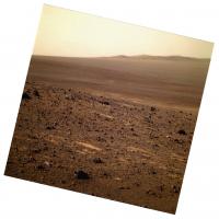
Senior Member Group: Members Posts: 2837 Joined: 22-April 05 From: Ridderkerk, Netherlands Member No.: 353 |
The Panoramic L2 view of Endeavour Crater.
Taken on Sol 2715. Jan van Driel
|
|
|
|
|
|
|
Sep 17 2011, 01:29 PM
Post
#78
|
|
|
Member Group: Members Posts: 754 Joined: 9-February 07 Member No.: 1700 |
Beautiful Pan von Jan! Now I understand the tilted perspective in NickF's clip.
|
|
|
|
|
Sep 17 2011, 01:42 PM
Post
#79
|
||
|
Member Group: Members Posts: 107 Joined: 29-January 09 Member No.: 4589 |
QUOTE (brellis @ Sep 17 2011, 07:29 AM) Beautiful Pan von Jan! Now I understand the tilted perspective in NickF's clip. Indeed, the rover is on a c. 10 degree slope at the moment. Here's the straightened version of my previous composite.
-------------------- Protein structures and Mars fun - http://www.flickr.com/photos/nick960/
|
|
|
|
|
|
|
Sep 17 2011, 02:28 PM
Post
#80
|
|
|
Senior Member Group: Members Posts: 4252 Joined: 17-January 05 Member No.: 152 |
The numbers we've seen indicate tau has dropped a fair bit in the last month or so, but with these new pancams we can directly see how much the transparency has improved in the last few weeks. Compare these frames from 2679 and 2718 looking across to Iazu:
http://marsrovers.jpl.nasa.gov/gallery/all...00P2384L2M1.JPG http://qt.exploratorium.edu/mars/opportuni...2M1.JPG?sol2718 |
|
|
|
|
Sep 17 2011, 03:35 PM
Post
#81
|
|
|
Senior Member Group: Moderator Posts: 3431 Joined: 11-August 04 From: USA Member No.: 98 |
According to the database it's the "Endeavour 1" mosaic, parts 1 and 2. Once it's down, the L257 color version should be really something. The color parts we've seen are already amazing. Lot of work to put it all together, though.
|
|
|
|
|
Sep 17 2011, 05:09 PM
Post
#82
|
|||
|
Senior Member Group: Members Posts: 4252 Joined: 17-January 05 Member No.: 152 |
Thanks for the stitches, guys - this is a stunning view. Lots of colour variation too - the L2's are showing very different details than the L7's.
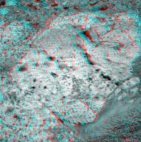
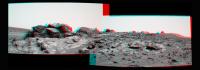
Here's a long baseline anaglyph from sols 2679 and 2718. The lighting is pretty different between the frames, and the stereo effect is pretty extreme for Solander point, so this may be one for the hard-core anaglyphers out there. Some nice structure on the inner slope of Tribulation, though.
Here's a cross-eyed version for those using stereo photo maker or the like:
|
||
|
|
|
||
|
Sep 17 2011, 05:18 PM
Post
#83
|
|
|
Junior Member Group: Members Posts: 98 Joined: 17-July 11 From: Pasadena, CA Member No.: 6066 |
Heads up for a RAT hole sometime tonight!
-m |
|
|
|
|
Sep 18 2011, 01:58 AM
Post
#84
|
|
 Member Group: Members Posts: 399 Joined: 28-August 07 From: San Francisco Member No.: 3511 |
Thanks to everyone for stitching the latest thrilling pan... what an amazing place this is...
-------------------- 'She drove until the wheels fell off...'
|
|
|
|
|
Sep 18 2011, 11:19 AM
Post
#85
|
||
|
Senior Member Group: Members Posts: 2837 Joined: 22-April 05 From: Ridderkerk, Netherlands Member No.: 353 |
If you want a new background on your computerscreen
here is the one. Jan van Driel
|
|
|
|
|
|
|
Sep 18 2011, 12:16 PM
Post
#86
|
|
 Senior Member Group: Moderator Posts: 2785 Joined: 10-November 06 From: Pasadena, CA Member No.: 1345 |
"Just wait for me in the car while I go run up that hill for a sec..."
-------------------- Some higher resolution images available at my photostream: http://www.flickr.com/photos/31678681@N07/
|
|
|
|
|
Sep 18 2011, 06:42 PM
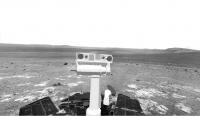
Post
#87
|
|
|
Senior Member Group: Members Posts: 2998 Joined: 30-October 04 Member No.: 105 |
Nice preliminary RAT MI's this morning, and I was able to get things straightened out and produce a couple of IDD location images
 http://i142.photobucket.com/albums/r91/wil...L2M1--annot.jpg Other images at the P'bucket site linked below. --Bill -------------------- |
|
|
|
|
Sep 19 2011, 12:03 AM
Post
#88
|
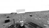
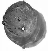
||
|
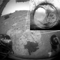
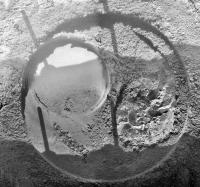
Junior Member Group: Members Posts: 52 Joined: 1-March 11 From: Houston, USA Member No.: 5860 |
Post-RAT imagery.
|
|
|
|
|
|
|
Sep 19 2011, 01:07 AM
Post
#89
|
|
|
Member Group: Members Posts: 139 Joined: 14-October 05 From: Toronto, Canada Member No.: 529 |
Wow! That rock was awfully soft...look at all of the powder.
-------------------- -- Robin
|
|
|
|
|
Sep 19 2011, 02:15 AM
Post
#90
|
|
 Administrator Group: Admin Posts: 5172 Joined: 4-August 05 From: Pasadena, CA, USA, Earth Member No.: 454 |
I'm glad the old girl wasn't given anything too difficult to chew
-------------------- My website - My Patreon - @elakdawalla on Twitter - Please support unmannedspaceflight.com by donating here.
|
|
|
|
|
Sep 19 2011, 02:39 AM
Post
#91
|
|
|
Senior Member Group: Members Posts: 1018 Joined: 29-November 05 From: Seattle, WA, USA Member No.: 590 |
Is there a nice summary somewhere of what instruments are still working and what sort of science Opportunity is still able to do? Obviously the pictures alone are still spectacular, but I'm wondering what else is still working.
--Greg |
|
|
|
|
Sep 19 2011, 02:45 AM
Post
#92
|
|
|
Founder Group: Chairman Posts: 14433 Joined: 8-February 04 Member No.: 1 |
Pancam - Fine, and less dusty than it has been
MiniTES - Bust IDD - Azimuth joint bust - can position instrument along a vertical plane, not full 3D space. APXS - Fine MI - Fine RAT - Fine ( but obviously, teeth are consumed to near death ) Mossbauer - VERY VERY tired. We're > 10 half-lives into it - so integrations that would have taken 6 hrs could technically take > 6 months. A good integration now would involved several weeks. |
|
|
|
|
Sep 19 2011, 02:52 AM
Post
#93
|
|
|
Administrator Group: Admin Posts: 5172 Joined: 4-August 05 From: Pasadena, CA, USA, Earth Member No.: 454 |
I can't help but think that if I were the MER team I'd aim for a likely looking rock in early November, do some documentation, put out the Moessbauer, and take a nice long Thanksgiving & Christmas holiday while it integrates!
-------------------- My website - My Patreon - @elakdawalla on Twitter - Please support unmannedspaceflight.com by donating here.
|
|
|
|
|
Sep 19 2011, 03:37 AM
Post
#94
|
|
|
Senior Member Group: Members Posts: 4252 Joined: 17-January 05 Member No.: 152 |
From Lenda's blog:
QUOTE Squyres put down a lien to get a super-resolution panorama of the entirety of Endeavour Crater, and it has taken the better part of a week to get it all done. Super res? |
|
|
|
|
Sep 19 2011, 04:01 AM
Post
#95
|
|
 Senior Member Group: Members Posts: 2228 Joined: 1-December 04 From: Marble Falls, Texas, USA Member No.: 116 |
That rock was incredibly soft. I wasn't expecting that. In retrospect, perhaps I should have expected it. The outcrop is worn down just as flat as the surrounding Meridiani sandstones, so why wouldn't we expect it to be soft?
-------------------- ...Tom
I'm not a Space Fan, I'm a Space Exploration Enthusiast. |
|
|
|
|
Sep 19 2011, 05:23 AM
Post
#96
|
|
|
Senior Member Group: Members Posts: 1585 Joined: 14-October 05 From: Vermont Member No.: 530 |
QUOTE (djellison @ Sep 18 2011, 09:45 PM) MiniTES - Bust Or dust. Depends on how you see it. They do gamely keep checking it. |
|
|
|
|
Sep 19 2011, 05:59 AM
Post
#97
|
|
|
Member Group: Members Posts: 507 Joined: 10-September 08 Member No.: 4338 |
QUOTE (CosmicRocker @ Sep 18 2011, 09:01 PM) That rock was incredibly soft. Does that mean it is not basaltic? |
|
|
|
|
Sep 19 2011, 06:30 AM
Post
#98
|
|
|
Founder Group: Chairman Posts: 14433 Joined: 8-February 04 Member No.: 1 |
QUOTE (stevesliva @ Sep 18 2011, 10:23 PM) Or dust. Depends on how you see it. They do gamely keep checking it. Check the documentation for the MER Analysts Notebook. For example - Sol 2261-2267 MER B Downlink Report QUOTE Opportunity is healthy and all* subsystems are nominal as of the Sol 2267 UHF downlink. Energy is currently 296 Whr with Tau at 0.370 and a dust factor of 0.5820 as of Sol 2267. *except the Mini-Thermal Emission Spectrometer (MTES) which has experienced a failure. Investigations into the Mini-TES failure are ongoing. or Sol 2281-2287 MER B Downlink Report QUOTE [Mini-TES, the miniature Thermal Emission Spectrometer experienced an anomaly on Sol 2257 which is currently being investigated.] later, you will just find QUOTE *with the exception of a known problem with Mini-TES as of the Sol 2308 downlink. Or from the excellent : http://www.planetary.org/news/2011/0901_Ma...ver_Update.html QUOTE Last Sunday, the rover's Sol 2700, the team decided to have the rover conduct another set of diagnostics on the miniature thermal emission spectrometer (Mini-TES) that began acting up last year and hasn't been working since. "Were all about trying to exhaust even remotely likely possibilities," noted Nelson. Opportunity followed her commands to exercise the back-up laser and back-up optical switch. Or going back further in time http://www.planetary.org/news/2011/0430_Ma...ate_Spirit.html QUOTE Last year, after being turned on, the Mini-TES failed to conduct a transferring kind of "handshake" with the PMA. "It timed out, and then said it wasn't talking to the flight software, and it was also not properly commanding the motors that would have changed the PMA azimuth, and we got a PMA fault," Nelson recounted. The ensuing diagnostics indicated the PMA azimuth motor is fine, and the issue is likely between the Mini-TES and the motor control board. This month, the Mini-TES exhibited more anomalous behavior. Specifically, it failed to draw power. A functioning Mini-TES should draw 200-250 milliamperes up to about ¼ amp, according to Nelson. "We're not seeing that current draw," he said. That would seem to suggest that the Mini-TES is simply not turning on, or that something somewhere between the instrument and motor control board has failed. Although the instrument investigation is continuing, the Mini-TES remains, Nelson said, "effectively out of commission." It is, as I said.... bust. |
|
|
|
|
Sep 19 2011, 07:40 AM
Post
#99
|
|
|
Senior Member Group: Members Posts: 1045 Joined: 17-February 09 Member No.: 4605 |
QUOTE (CosmicRocker @ Sep 19 2011, 05:01 AM) ..... The outcrop is worn down just as flat as the surrounding Meridiani sandstones, so why wouldn't we expect it to be soft? Indeed. Remember Clovis rock - a Spirit RAT in 2004 - image below? Looks a bit softer than Opportunity's last grind. But this is a breccia, probably suevite and the weathering susceptibilities of the constituent elements are different to the Moh's scale resistance to abrasion. http://marsrover.nasa.gov/gallery/press/sp...o-A223R1_br.jpg |
|
|
|
|
Sep 19 2011, 09:40 AM
Post
#100
|
||
|
Senior Member Group: Members Posts: 2837 Joined: 22-April 05 From: Ridderkerk, Netherlands Member No.: 353 |
Mi cam Sol 2719.
Jan van Driel
|
|
|
|
|
|
 |

|
Lo-Fi Version | Time is now: 8th June 2024 - 06:43 PM |
|
RULES AND GUIDELINES Please read the Forum Rules and Guidelines before posting. IMAGE COPYRIGHT |
OPINIONS AND MODERATION Opinions expressed on UnmannedSpaceflight.com are those of the individual posters and do not necessarily reflect the opinions of UnmannedSpaceflight.com or The Planetary Society. The all-volunteer UnmannedSpaceflight.com moderation team is wholly independent of The Planetary Society. The Planetary Society has no influence over decisions made by the UnmannedSpaceflight.com moderators. |
SUPPORT THE FORUM Unmannedspaceflight.com is funded by the Planetary Society. Please consider supporting our work and many other projects by donating to the Society or becoming a member. |
|