The Surveyor Lunar Roving Vehicle, Plans for a rover to accompany Surveyor |

The Surveyor Lunar Roving Vehicle, Plans for a rover to accompany Surveyor |
 Aug 18 2005, 04:05 PM Aug 18 2005, 04:05 PM
Post
#1
|
|
|
Senior Member  Group: Members Posts: 2454 Joined: 8-July 05 From: NGC 5907 Member No.: 430 |
Surveyor Lunar Roving Vehicle, phase I. Volume V - System evaluation Final technical report
http://ntrs.nasa.gov/archive/nasa/casi.ntr..._1966004162.pdf -------------------- "After having some business dealings with men, I am occasionally chagrined,
and feel as if I had done some wrong, and it is hard to forget the ugly circumstance. I see that such intercourse long continued would make one thoroughly prosaic, hard, and coarse. But the longest intercourse with Nature, though in her rudest moods, does not thus harden and make coarse. A hard, sensible man whom we liken to a rock is indeed much harder than a rock. From hard, coarse, insensible men with whom I have no sympathy, I go to commune with the rocks, whose hearts are comparatively soft." - Henry David Thoreau, November 15, 1853 |
 |
 
|
 |
|
Aug 18 2005, 10:28 PM
Post
#2
|
||
 Senior Member Group: Members Posts: 2488 Joined: 17-April 05 From: Glasgow, Scotland, UK Member No.: 239 |
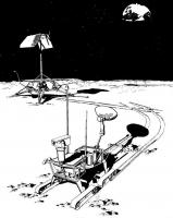
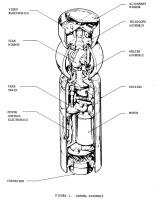
And here's a grab from the .PDF:
Attached thumbnail(s)
-------------------- Remember: Time Flies like the wind - but Fruit Flies like bananas!
|
|
|
|
|
|
|
Aug 18 2005, 10:40 PM
Post
#3
|
|||
|
Senior Member Group: Members Posts: 2488 Joined: 17-April 05 From: Glasgow, Scotland, UK Member No.: 239 |
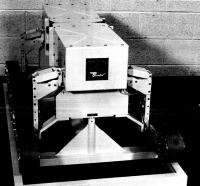
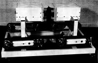
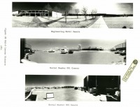
And a couple of photos of the Engineering Test Model:
Attached thumbnail(s)
-------------------- Remember: Time Flies like the wind - but Fruit Flies like bananas!
|
||
|
|
|
||
|
Aug 19 2005, 02:32 AM
Post
#4
|
|
 Senior Member Group: Members Posts: 1281 Joined: 18-December 04 From: San Diego, CA Member No.: 124 |
"Bendix"
 I love it! (NASA needs to do more with that ElectroLux font again....) -------------------- Lyford Rome
"Zis is not nuts, zis is super-nuts!" Mathematician Richard Courant on viewing an Orion test |
|
|
|
|
Aug 19 2005, 03:11 PM
Post
#5
|
|
 Member Group: Members Posts: 562 Joined: 29-March 05 Member No.: 221 |
bizzare choice of mobility system
|
|
|
|
|
Aug 21 2005, 04:30 PM
Post
#6
|
|
|
Senior Member Group: Members Posts: 2454 Joined: 8-July 05 From: NGC 5907 Member No.: 430 |
Designer of Surveyor scoop dies
Professor who designed lunar scoop dies PASADENA -- Ronald Scott, who designed a scoop that collected lunar soil during an unmanned moon mission, died Tuesday after a long battle with cancer, the California Institute of Technology said in a statement. He was 76. http://www.pasadenastarnews.com/Stories/0,...3019995,00.html -------------------- "After having some business dealings with men, I am occasionally chagrined,
and feel as if I had done some wrong, and it is hard to forget the ugly circumstance. I see that such intercourse long continued would make one thoroughly prosaic, hard, and coarse. But the longest intercourse with Nature, though in her rudest moods, does not thus harden and make coarse. A hard, sensible man whom we liken to a rock is indeed much harder than a rock. From hard, coarse, insensible men with whom I have no sympathy, I go to commune with the rocks, whose hearts are comparatively soft." - Henry David Thoreau, November 15, 1853 |
|
|
|
|
Aug 24 2005, 02:57 PM
Post
#7
|
|
|
Senior Member Group: Members Posts: 2454 Joined: 8-July 05 From: NGC 5907 Member No.: 430 |
Surveyor Lunar Roving Vehicle, phase I. Volume III - Preliminary design and system description. Book I - System description and performance characteristics Final technical report
http://ntrs.nasa.gov/archive/nasa/casi.ntr..._1966004186.pdf -------------------- "After having some business dealings with men, I am occasionally chagrined,
and feel as if I had done some wrong, and it is hard to forget the ugly circumstance. I see that such intercourse long continued would make one thoroughly prosaic, hard, and coarse. But the longest intercourse with Nature, though in her rudest moods, does not thus harden and make coarse. A hard, sensible man whom we liken to a rock is indeed much harder than a rock. From hard, coarse, insensible men with whom I have no sympathy, I go to commune with the rocks, whose hearts are comparatively soft." - Henry David Thoreau, November 15, 1853 |
|
|
|
|
Aug 25 2005, 01:52 AM
Post
#8
|
|
|
Solar System Cartographer Group: Members Posts: 10196 Joined: 5-April 05 From: Canada Member No.: 227 |
I wonder if there are any discussions among these reports (I mean among other volumes not linked here) of possible landing targets? But perhaps they didn't get that far, just planning that they would characterize Apollo sites when they were eventually selected from Orbiter images.
Phil -------------------- ... because the Solar System ain't gonna map itself.
Also to be found posting similar content on https://mastodon.social/@PhilStooke Maps for download (free PD: https://upload.wikimedia.org/wikipedia/comm...Cartography.pdf NOTE: everything created by me which I post on UMSF is considered to be in the public domain (NOT CC, public domain) |
|
|
|
| Guest_BruceMoomaw_* |
Aug 25 2005, 05:30 AM
Post
#9
|
|
Guests |
While I strongly doubt that Phil doesn't know this, the two definitive acccounts of the process by which scientifically interesting landing sites were selected over the course of the early Apollo program seem to be Don Wilhelms' "To A Rocky Moon" and William Compton's "Where No Man Has Gone Before" (which can be found at http://www.hq.nasa.gov/office/pao/History/...4/contents.html ).
|
|
|
|
|
Aug 25 2005, 12:25 PM
Post
#10
|
|
|
Solar System Cartographer Group: Members Posts: 10196 Joined: 5-April 05 From: Canada Member No.: 227 |
Thanks, Bruce - yes, I do know those, of course. I was thinking specifically about the Surveyor Rovers, and whether their purpose was only to give ground truth to Apollo sites AFTER they were chosen, or if other science targets might also be chosen specifically for Surveyor.
The two references you mention are interesting. Compton gives summaries of various stages in the site selection process, but when I looked at the minutes I found a few cases where Compton's dates seem to be mistaken - a decision would be related to a different meeting than the one at which it was made. This might be because they had the habit of including a package of presentation materials for the last meeting with the minutes for the current meeting, inviting misunderstanding later. Wilhelms, of course, wrote a fabulous book about all this. But he intended more, preparing many illustrations. The publisher rejected the idea and left him with the book we see. So he packaged up his illustrations and lots of other material from the site selection and put it in binders which he deposited in the Branch History Collection at Flagstaff. I was able to get hold of most of it and make copies, and luckily my Atlas will be able to contain it all. The only things I couldn't get were a couple of binders from the last two missions. Jack Schmitt had borrowed them and has been hanging on to them. Phil -------------------- ... because the Solar System ain't gonna map itself.
Also to be found posting similar content on https://mastodon.social/@PhilStooke Maps for download (free PD: https://upload.wikimedia.org/wikipedia/comm...Cartography.pdf NOTE: everything created by me which I post on UMSF is considered to be in the public domain (NOT CC, public domain) |
|
|
|
|
Aug 25 2005, 02:33 PM
Post
#11
|
|
 Member Group: Members Posts: 648 Joined: 9-May 05 From: Subotica Member No.: 384 |
Hi !
Does anybody knows where I can find something about future Lunar Lander/Rover (2009)??? or whatever they are calling it... 
-------------------- The scientist does not study nature because it is useful; he studies it because he delights in it, and he delights in it because it is beautiful.
Jules H. Poincare My "Astrophotos" gallery on flickr... |
|
|
|
|
Aug 25 2005, 05:59 PM
Post
#12
|
|
|
Member Group: Members Posts: 128 Joined: 5-May 04 Member No.: 74 |
QUOTE (lyford @ Aug 19 2005, 02:32 AM) "Bendix" I love it! (NASA needs to do more with that ElectroLux font again....)  I think that was the logo of the Bendix Corporation at the time, which had a contract with NASA to develop the vehicle. (Bendix later merged with AlliedSignal and is now part of Honeywell.) |
|
|
|
|
Aug 25 2005, 08:32 PM
Post
#13
|
|
|
Senior Member Group: Members Posts: 2488 Joined: 17-April 05 From: Glasgow, Scotland, UK Member No.: 239 |
Phil:
The Surveyor Rovers appear to have been intended to specifically check out the *exact* landing site for a future LM flight - in other words, the LM would land beside the Surveyor. I don't remember seeing any specific landing targets for the Surveyors in the report, but the Surveyors themselves would have become the Apollo targets. Much of the report was about the statistical design of a 'semi-drunkard's walk' ground surveying process. Bob Shaw -------------------- Remember: Time Flies like the wind - but Fruit Flies like bananas!
|
|
|
|
|
Aug 25 2005, 09:35 PM
Post
#14
|
|
|
Solar System Cartographer Group: Members Posts: 10196 Joined: 5-April 05 From: Canada Member No.: 227 |
Yes, I saw that... It's interesting that both the Soviets and the US initially thought they would need robotic rovers to survey landing areas and deploy landing beacons. In the end orbital images were all they really needed.
I was secretely hoping that the Surveyor Rovers, in addition to the Apollo certification mission goal, would have been considered for separate science missions. But 'twere not to be, apparently. People complain about science being pushed aside by the human space flight program today, but it was almost worse during Apollo. Phil -------------------- ... because the Solar System ain't gonna map itself.
Also to be found posting similar content on https://mastodon.social/@PhilStooke Maps for download (free PD: https://upload.wikimedia.org/wikipedia/comm...Cartography.pdf NOTE: everything created by me which I post on UMSF is considered to be in the public domain (NOT CC, public domain) |
|
|
|
|
Dec 16 2005, 06:07 PM
Post
#15
|
|
|
Member Group: Members Posts: 903 Joined: 30-January 05 Member No.: 162 |
Another minor mystery is what happened to Surveyor 4.
It was launched 7/14/67 and during landing on 7/17, contact was lost just a couple of minutes before touchdown. Is it possible the radio failed and the craft landed successfully? Has any subsequent probe imaged the site for a new crater? I'm not sure of the landing sequence, but if contact was lost ~2 minutes, wouldn't NASA have a good idea of the precise spot to look at? |
|
|
|
|
Dec 16 2005, 06:33 PM
Post
#16
|
|
|
Solar System Cartographer Group: Members Posts: 10196 Joined: 5-April 05 From: Canada Member No.: 227 |
Yes, we have a good idea where to look. 0.3 degrees N, 1.62 degrees W, which assumes a nominal landing but loss of telemetry (from the Surveyor Program final report). More likely it crashed nearby.
This area is just outside the high resolution Lunar Orbiter coverage so there is no pre-impact high resolution coverage. It might be covered by Apollo 10 Hasselblad images VERY near the terminator - lots of areas lost in shadow. But they would be nowhere near detailed enough to identify the impact crater or (even more so) a landed spacecraft. Clementine images would be useless for this - far too low resolution. However, imaging such sites is a goal of Lunar Reconnaissance Orbiter. Even so it's not certain it could be identified without good pre-impact imaging. You are, though, mistaken in thinking that NASA might have an interest in looking for it. NASA is purely an engineering organization. This sort of search, with no value other than historical, is only of interest to people like me. Phil -------------------- ... because the Solar System ain't gonna map itself.
Also to be found posting similar content on https://mastodon.social/@PhilStooke Maps for download (free PD: https://upload.wikimedia.org/wikipedia/comm...Cartography.pdf NOTE: everything created by me which I post on UMSF is considered to be in the public domain (NOT CC, public domain) |
|
|
|
|
Dec 16 2005, 11:10 PM
Post
#17
|
|
 Senior Member Group: Members Posts: 3419 Joined: 9-February 04 From: Minneapolis, MN, USA Member No.: 15 |
Well, certainly such things are of interest to me, and I'm sure to many people who visit and post to this forum. But, then again, I guess we all rather fit the definition of "people like you," Phil.
 -the other Doug -------------------- The trouble ain't that there is too many fools, but that the lightning ain't distributed right. -Mark Twain
|
|
|
|
| Guest_BruceMoomaw_* |
Dec 16 2005, 11:31 PM
Post
#18
|
|
Guests |
Contact was lost instantaneously at exactly the time (2 seconds before retro burnout) when the burndown of fuel would have allowed one of the seamed sections of propellant glued to the sides of the combustion chamber to peel loose and get sucked into the nozzle, causing the motor to explode -- so the betting is that that is what happened to it. But as with Mars Observer and MPL, there still are other possibilities (explosion of a gas tank or a shock absorber, power line coming loose, etc.) -- and one of those possibilities is that the transmitter's connecting line failed at that point. I admit I'd still be interested in finding out, and maybe LRO will tell us.
|
|
|
|
|
Dec 17 2005, 12:10 AM
Post
#19
|
|
|
Senior Member Group: Members Posts: 2488 Joined: 17-April 05 From: Glasgow, Scotland, UK Member No.: 239 |
Hopefully, when Apollo-On-Steroids comes to pass, there'll be a SIM-Bay-On-Steroids in the CEV SM which will routinely save multi megapixel images of the surface with said data being returned to Earth (without an EVA) simply by dumping onto dedicated data recorders within the return vehicle. That would make all previous survey vehicles fade into obscurity, and at minimal extra cost.
Bob Shaw -------------------- Remember: Time Flies like the wind - but Fruit Flies like bananas!
|
|
|
|
|
Dec 17 2005, 06:24 AM
Post
#20
|
|
|
Senior Member Group: Members Posts: 1870 Joined: 20-February 05 Member No.: 174 |
Bob Shaw: "Hopefully, when Apollo-On-Steroids comes to pass, there'll be a SIM-Bay-On-Steroids in the CEV SM which will routinely save multi megapixel images of the surface ...."
Actually, dedicated orbiters will be far more useful. If you want something like 10 centimeter resolution imagery of selected lunar surface areas, you're talking about a serious camera, even in low 15 km constantly-trimmed-to-keep-from-crashing orbit. Note that the orbital photographic mapping on Apollo 17 was nearly wasted since the orbit nearly duplicated the Apollo 15 orbit, other than being at an earlier time of the month, while the coverage on Apollo 16 was limited to areas very very close to the equator, so the groundtrack barely varied as the Moon rotated under the orbit. Actually, there is real engineering reason to rephotograph landing and impact sites. The bigger the statistical sample we get of recent, low velocity (compared with meteorites) impact craters on the moon, the better we understand the structure and mechanical properties of the lunar regolith to depths below where we drilled. |
|
|
|
|
Jan 23 2006, 06:17 PM
Post
#21
|
|
|
Senior Member Group: Members Posts: 2454 Joined: 8-July 05 From: NGC 5907 Member No.: 430 |
Surveyor: Landing Radar Test Program Review Final Report
http://ntrs.nasa.gov/archive/nasa/casi.ntr..._1967028593.pdf and Surveyor Spacecraft System - Surveyor 2 Flight Performance Final Report http://ntrs.nasa.gov/archive/nasa/casi.ntr..._1968009188.pdf -------------------- "After having some business dealings with men, I am occasionally chagrined,
and feel as if I had done some wrong, and it is hard to forget the ugly circumstance. I see that such intercourse long continued would make one thoroughly prosaic, hard, and coarse. But the longest intercourse with Nature, though in her rudest moods, does not thus harden and make coarse. A hard, sensible man whom we liken to a rock is indeed much harder than a rock. From hard, coarse, insensible men with whom I have no sympathy, I go to commune with the rocks, whose hearts are comparatively soft." - Henry David Thoreau, November 15, 1853 |
|
|
|
|
Mar 19 2006, 02:34 AM
Post
#22
|
|
|
Senior Member Group: Members Posts: 2454 Joined: 8-July 05 From: NGC 5907 Member No.: 430 |
Some very interesting photos of a Surveyor test here:
http://www.ninfinger.org/~sven/models/vaul...eyor/index.html It would not surprise me if a hiker coming upon such a test back then might first mistake it for an alien landing. Theses images include a group set of how the instruments on all the Surveyors became more complex with each mission: http://www.ninfinger.org/~sven/models/vaul...yorb/index.html Photos and diagrams of the Surveyor 3 scoop: http://www.ninfinger.org/~sven/models/vaul...pler/index.html -------------------- "After having some business dealings with men, I am occasionally chagrined,
and feel as if I had done some wrong, and it is hard to forget the ugly circumstance. I see that such intercourse long continued would make one thoroughly prosaic, hard, and coarse. But the longest intercourse with Nature, though in her rudest moods, does not thus harden and make coarse. A hard, sensible man whom we liken to a rock is indeed much harder than a rock. From hard, coarse, insensible men with whom I have no sympathy, I go to commune with the rocks, whose hearts are comparatively soft." - Henry David Thoreau, November 15, 1853 |
|
|
|
| Guest_BruceMoomaw_* |
Mar 20 2006, 02:09 AM
Post
#23
|
|
Guests |
We mustn't forget that a footpad magnet was first carried on Surveyor 4, that a second one was added to Footpad #3 on Surveyor 7 (although neither of them touched the soil, and the surface sampler wan't positioned to pour dirt on the footpad for Surveyor 7 as it was for numbers 3 and 4), that there were also two small magnets on the surface sampler scoop door for Surveyor 7, and that there were two frame mirrors starting on #3 to allow views of the surface underneath the craft -- and a third starting with #6 to provide a view of the surface onto which the alpha-scatter instrument would then be lowered. Finally, they switched over from color to polarizing filters starting with #6.
Actually, after the failure of Ranger 5, the alpha-scatter instrument, magnets and camera filters were the ONLY instruments put on ANY unmanned US Moon probes -- except for the two attempts at lunar-orbiting Explorers -- that weren't totally connected with studies necessary for the Apollo landings. As I've said before, it's a pity that they didn't put a copy of the Ranger gamma-ray spectrometer on Lunar Orbiter 5 -- as they would have put it on #6 if that mission had been flown. |
|
|
|
|
Mar 20 2006, 08:15 AM
Post
#24
|
|
|
Senior Member Group: Members Posts: 1870 Joined: 20-February 05 Member No.: 174 |
Note that all 5 Lunar Orbiters carried two small but technically significant engineering instruments.
Radiation dosimeters recorded the ionizing radiation flux to monitor dosage for possible film-fogging problems. Data from the instruments provided confidence that modeled radiation exposure probabilities for Apollo astronauts were likely reasonably accurate. More scientificaly interesting, each Orbiter carried a set of meteoroid impact penetration cells, similar to those carried on the Pegasus spacecraft in low Earth orbit and Pioneeds 10 and 11 past Jupiter and Saturn. I think there is one of those NASA-CR (green covered) series Contractors Report summarising results from those measurements. Not much data with low statistics, but very reassuring to know approximately what was or more importantly was NOT there. AIMP (Anchored Interplanetary Monitoring Platform) Explorer 33 (I think I have the numbers right) was mis-launched by a small amount (I think with a low apoapsis) and was not able to make lunar orbit. Explorer 35 was entirely successful and operated for several years in lunar orbit providing the first really good set of particles and fields data at the Moon. Also lunar orbiting, but utterly not-lunar-oriented, was the low frequency Radio Astronomy Explorer with L-O-N-G dipole antennas. It used or attempted to use lunar occultatin to identify distant low frequency sources, together with distance from Earth's radio noise. I never heard much science from the mission and what I did wasn't that impressive, but it did fly. |
|
|
|
|
Mar 20 2006, 01:08 PM
Post
#25
|
|
|
Senior Member Group: Members Posts: 2488 Joined: 17-April 05 From: Glasgow, Scotland, UK Member No.: 239 |
I wonder whether the Radio Astronomy Explorer is still in Lunar orbit? As I recall, it was in a high orbit, unlike practically all the rest of the spacecraft which have entered Lunar orbit (it also had h-u-g-e wire antennae).
Bob Shaw -------------------- Remember: Time Flies like the wind - but Fruit Flies like bananas!
|
|
|
|
|
Mar 20 2006, 04:51 PM
Post
#26
|
|
|
Member Group: Members Posts: 212 Joined: 19-July 05 Member No.: 442 |
QUOTE (Bob Shaw @ Mar 20 2006, 09:08 PM) I wonder whether the Radio Astronomy Explorer is still in Lunar orbit? As I recall, it was in a high orbit, unlike practically all the rest of the spacecraft which have entered Lunar orbit (it also had h-u-g-e wire antennae). Bob Shaw I have attempted to determine this from what I would consider to be the best sources available, namely the NASA homepage and Astronautix.com. However, I have not been able to resolve the question. What I have found is the basic information on the craft itself. The information I have found is as follows: 1. R.A.E Data from Astronautix.com 2. Nasa Projects Homepage I will do a further search and see what, if anything I can dig up. |
|
|
|
| Guest_BruceMoomaw_* |
Mar 20 2006, 05:55 PM
Post
#27
|
|
Guests |
Yeah, Ed Strick was right about all the Lunar Orbiter instruments -- but they were Apollo-related (or, in the case of the radiation detectors, also used to measure radiation fogging on the photos).
As for Explorer 33: its Delta actually launched it too FAST to intercept the Moon (since it had no midcourse motor), so they immediately fired its orbital-insertion retromotor to put it into an elongated Earth orbit rather than having it go into solar orbit. It was hardly a total scientific loss -- they just added it to the regular IMP Earth-orbiting network. |
|
|
|
| Guest_BruceMoomaw_* |
Mar 20 2006, 08:51 PM
Post
#28
|
|
Guests |
Oops. Ed already mentioned the L.O. radiation detectors being an integral part of the photography package. Sorry.
|
|
|
|
|
Mar 21 2006, 03:06 PM
Post
#29
|
|
|
Member Group: Members Posts: 212 Joined: 19-July 05 Member No.: 442 |
Found a little additional information on the lunar orbiting Radio Astronomy Explorer (Explorer 49). It's at the NSSDC Spacecraft Database and includes basic information on the spacecraft, the instruments fitted and most importantly an email address for further information.
Hope this helps. |
|
|
|
|
Mar 21 2006, 08:16 PM
Post
#30
|
|
|
Senior Member Group: Members Posts: 2454 Joined: 8-July 05 From: NGC 5907 Member No.: 430 |
Microbiological Burden on the Surfaces of Explorer XXXIII
http://www.pubmedcentral.gov/articlerender...ubmedid=6053173 Interim flight report, Anchored Interplanetary Monitoring Platform AIMP I - Explorer XXXIII http://ntrs.nasa.gov/archive/nasa/casi.ntr..._1967009370.pdf To put it in layperson's terms, Explorer 49's antennae were longer than the Empire State Building. Integration plan for the Radio Astronomy Explorer /RAE/ spacecraft http://ntrs.nasa.gov/archive/nasa/casi.ntr..._1967024524.pdf -------------------- "After having some business dealings with men, I am occasionally chagrined,
and feel as if I had done some wrong, and it is hard to forget the ugly circumstance. I see that such intercourse long continued would make one thoroughly prosaic, hard, and coarse. But the longest intercourse with Nature, though in her rudest moods, does not thus harden and make coarse. A hard, sensible man whom we liken to a rock is indeed much harder than a rock. From hard, coarse, insensible men with whom I have no sympathy, I go to commune with the rocks, whose hearts are comparatively soft." - Henry David Thoreau, November 15, 1853 |
|
|
|
| Guest_BruceMoomaw_* |
Mar 21 2006, 11:34 PM
Post
#31
|
|
Guests |
QUOTE (gndonald @ Mar 21 2006, 03:06 PM) Found a little additional information on the lunar orbiting Radio Astronomy Explorer (Explorer 49). It's at the NSSDC Spacecraft Database and includes basic information on the spacecraft, the instruments fitted and most importantly an email address for further information. The very last US lunar mission until Clementine -- unless you count Galileo's long-range observations of the Moon during its two Earth flybys, which actually did provide important new information on it, including confirmation of the existence of the Aitken Basin. (Explorer 49 did carry a wide-angle facsimile camera that photographed the Moon, but only to confirm its proper attitude orientation.) |
|
|
|
|
Mar 22 2006, 01:28 PM
Post
#32
|
|
|
Member Group: Members Posts: 212 Joined: 19-July 05 Member No.: 442 |
QUOTE (BruceMoomaw @ Mar 22 2006, 07:34 AM) The very last US lunar mission until Clementine -- unless you count Galileo's long-range observations of the Moon during its two Earth flybys, which actually did provide important new information on it, including confirmation of the existence of the Aitken Basin. (Explorer 49 did carry a wide-angle facsimile camera that photographed the Moon, but only to confirm its proper attitude orientation.) Interesting as the camera is not mentioned on the website I linked to. Were the pictures released in any form? |
|
|
|
|
Mar 22 2006, 04:34 PM
Post
#33
|
|
|
Solar System Cartographer Group: Members Posts: 10196 Joined: 5-April 05 From: Canada Member No.: 227 |
Bruce, I would sell my grandmother for one of those images.
Oh, sorry, Granny! Who'd have thought you were lurking here... Phil -------------------- ... because the Solar System ain't gonna map itself.
Also to be found posting similar content on https://mastodon.social/@PhilStooke Maps for download (free PD: https://upload.wikimedia.org/wikipedia/comm...Cartography.pdf NOTE: everything created by me which I post on UMSF is considered to be in the public domain (NOT CC, public domain) |
|
|
|
| Guest_BruceMoomaw_* |
Mar 22 2006, 08:28 PM
Post
#34
|
|
Guests |
There was one of 'em printed in "Science News" at the time, I believe (of the farside, if I remember correctly) -- although I remember the resolution as being lousy. Tell Granny I expect her to be a VERY good housekeeper -- she'll need to be one.
|
|
|
|
|
Mar 23 2006, 08:54 AM
Post
#35
|
|
|
Senior Member Group: Members Posts: 1870 Joined: 20-February 05 Member No.: 174 |
I never saw any images from the Explorer.. or that ?Muses-A? Japanese lunar swingby and orbiter mission, though I recall hearing it took some.
|
|
|
|
|
Mar 23 2006, 01:38 PM
Post
#36
|
|
|
Solar System Cartographer Group: Members Posts: 10196 Joined: 5-April 05 From: Canada Member No.: 227 |
Ted Stryk has two Hiten (MUSES-A) images (one of them a mosaic) on his website. They are low quality (4 bit, low resolution, just used for navigation purposes).
http://pages.preferred.com/%7Etedstryk/Hiten.html I'm now going to look for the Explorer 49 image Bruce mentioned. Of course, I expect the quality will be very poor. Phil -------------------- ... because the Solar System ain't gonna map itself.
Also to be found posting similar content on https://mastodon.social/@PhilStooke Maps for download (free PD: https://upload.wikimedia.org/wikipedia/comm...Cartography.pdf NOTE: everything created by me which I post on UMSF is considered to be in the public domain (NOT CC, public domain) |
|
|
|
|
Mar 26 2006, 12:29 AM
Post
#37
|
|
|
Solar System Cartographer Group: Members Posts: 10196 Joined: 5-April 05 From: Canada Member No.: 227 |
Bruce - an unexpected wrinkle has appeared in the Grandmother deal we were brokering. Not that Gran has an increasingly tectonic complexion, but that I looked through Science News for 1973, and I found nothing in the nature of an Explorer 49 image. There were two articles... one very brief... The first did have a schematic illustration of the satellite in lunar orbit, with a lunar photo behind the satellite, but clearly an Apollo photo. The article was from around the time of launch anyway. The second article described orbit insertion. Then nothing for 6 months.
Maybe I need took ahead into 74. Or is it possible the photo was in AW&ST or some such place instead? I'll look into that next. Phil -------------------- ... because the Solar System ain't gonna map itself.
Also to be found posting similar content on https://mastodon.social/@PhilStooke Maps for download (free PD: https://upload.wikimedia.org/wikipedia/comm...Cartography.pdf NOTE: everything created by me which I post on UMSF is considered to be in the public domain (NOT CC, public domain) |
|
|
|
| Guest_BruceMoomaw_* |
Mar 26 2006, 03:52 AM
Post
#38
|
|
Guests |
Dang. Well, I know I saw a small version of it SOMEWHERE, with the marker at the end of one of the RAE's very long gravity-gradient booms pointing toward a very wide-angle (and lousy resolution) view of the Moon, published very soon after the craft entered lunar orbit. I'll do a bit more research, so tell Granny not to get her hopes up.
|
|
|
|
|
Mar 26 2006, 09:14 AM
Post
#39
|
|
|
Senior Member Group: Members Posts: 1870 Joined: 20-February 05 Member No.: 174 |
The quality issue explains the public invisibility of Hiten images, but that "bail-out-you-fool!" (quick.. identify the quote) sequence is *NEAT*.
|
|
|
|
| Guest_BruceMoomaw_* |
Mar 26 2006, 01:33 PM
Post
#40
|
|
Guests |
Well, I haven't located any actual images from the Explorer 49 cameras on the Web -- but I have confirmed that both Radio Astronomy Explorers carried a pair of facsimile cameras to observe the behavior of the long deployed booms, and I've at least found the ID number for a published NASA report on the performance of Explorer 49's cameras (which had image compression of fully 32 to 1). This paper may be your best bet for finding actual images from it:
___________________________________ 12. On-board image compression for the RAE lunar mission Miller, W. H.; Lynch, T. J. NASA Center for AeroSpace Information (CASI) IEEE Transactions on Aerospace and Electronic Systems, AES-12, May 1976 , 19760501; May 1, 1976 The requirements, design, implementation, and flight performance of an on-board image compression system for the lunar orbiting Radio Astronomy Explorer-2 (RAE-2) spacecraft are described. The image to be compressed is a panoramic camera view of the long radio astronomy antenna booms used for gravity-gradient stabilization of the spacecraft. A compression ratio of 32 to 1 is obtained by a combination of scan line skipping and adaptive run-length coding. The compressed imagery data are convolutionally encoded for error protection. This image compression system occupies about 1000 cu cm and consumes 0.4 W. Accession ID: 76A34178 Document ID: 19760051212 |
|
|
|
|
Mar 26 2006, 02:14 PM
Post
#41
|
|
|
Solar System Cartographer Group: Members Posts: 10196 Joined: 5-April 05 From: Canada Member No.: 227 |
edstrick said: "The quality issue explains the public invisibility of Hiten images, but that "bail-out-you-fool!" (quick.. identify the quote) sequence is *NEAT*."
(speaking of Hiten images). One of the Mercury astronauts on viewing the Ranger 9 video transmission. Bruce, thanks for this. I will now try to track it down. If I find anything interesting I will see if I can get it up here. Granny would be proud. Phil -------------------- ... because the Solar System ain't gonna map itself.
Also to be found posting similar content on https://mastodon.social/@PhilStooke Maps for download (free PD: https://upload.wikimedia.org/wikipedia/comm...Cartography.pdf NOTE: everything created by me which I post on UMSF is considered to be in the public domain (NOT CC, public domain) |
|
|
|
|
Mar 26 2006, 02:29 PM
Post
#42
|
|
|
Senior Member Group: Members Posts: 3419 Joined: 9-February 04 From: Minneapolis, MN, USA Member No.: 15 |
You're correct, Phil, though I note you're unable to specify which of the seven said it.
It was Wally Schirra, by the way. -the other Doug -------------------- The trouble ain't that there is too many fools, but that the lightning ain't distributed right. -Mark Twain
|
|
|
|
|
Mar 26 2006, 04:46 PM
Post
#43
|
|
|
Solar System Cartographer Group: Members Posts: 10196 Joined: 5-April 05 From: Canada Member No.: 227 |
Fiends! - oh sorry, that's a typo - I am holding in my hands an image from Explorer 49... from Bruce's reference. As soon as our Science Library opened I was there - pretty pathetic, isn't it? Anyway, the article had one image plus a diagram of the wide-angle field of view. I'll post something tomorrow.
The scanner produced images with 2160 by 512 pixels covering 360 by 70 degrees. Over 100 images were taken, displayed in real time at Goddard and recorded on tape. Phil -------------------- ... because the Solar System ain't gonna map itself.
Also to be found posting similar content on https://mastodon.social/@PhilStooke Maps for download (free PD: https://upload.wikimedia.org/wikipedia/comm...Cartography.pdf NOTE: everything created by me which I post on UMSF is considered to be in the public domain (NOT CC, public domain) |
|
|
|
| Guest_BruceMoomaw_* |
Mar 27 2006, 01:59 AM
Post
#44
|
|
Guests |
The hell with Granny being PROUD -- Granny had better be DUTIFUL. I'm counting on you to fulfill your part of the deal. (Incidentally, I hope she's not allergic to cats.)
Am I correct in remembering that the resolution of that photo (wherever I did see it) was pretty pathetic? |
|
|
|
|
Mar 27 2006, 02:08 AM
Post
#45
|
|
|
Merciless Robot Group: Admin Posts: 8784 Joined: 8-December 05 From: Los Angeles Member No.: 602 |
OT a bit, here, but does anyone have an authoritative link to the complete history of the Explorer program? I was aware of Explorer 35, but had no idea that the series went all the way to 49...I mean, talk about an unheralded epic in the annals of spaceflight!
 Was the "Explorer" designation perhaps the US answer to "Cosmos" in some way, at some times...? -------------------- A few will take this knowledge and use this power of a dream realized as a force for change, an impetus for further discovery to make less ancient dreams real.
|
|
|
|
| Guest_BruceMoomaw_* |
Mar 27 2006, 02:44 AM
Post
#46
|
|
Guests |
QUOTE (nprev @ Mar 27 2006, 02:08 AM) OT a bit, here, but does anyone have an authoritative link to the complete history of the Explorer program? I was aware of Explorer 35, but had no idea that the series went all the way to 49...I mean, talk about an unheralded epic in the annals of spaceflight! Was the "Explorer" designation perhaps the US answer to "Cosmos" in some way, at some times...? Pretty much, where small (or relatively small) scientific satellites are concerned -- in fact it went up some way beyond that before they stopped numbering them and just started calling each one the "So-And-So" Explorer. I believe that finally started happening in the late 1970s, by which time the numbers had gotten up into the 50s. (They never numbered those whose launches failed, however -- except for Explorers 2 and 5.) |
|
|
|
| Guest_BruceMoomaw_* |
Mar 27 2006, 07:48 AM
Post
#47
|
|
Guests |
Here's a site that will tell you more about them than you wanted to know. It adds numbers to ALL the satellites officially declared to be Explorers and which made it into orbit -- right up to SWIFT, which is "Explorer 83" -- but I myself stopped seeing numbers attached to them about the time of the Dynamics Explorers (#62 and 63) in 1981. The last failed launch of an Explorer (which thus ended up unnumbered) seems to date all the way back to 1975 -- and the last one before that was in 1964!
http://www.cira.colostate.edu/ramm/hillger/scientific.htm |
|
|
|
|
Mar 27 2006, 04:13 PM
Post
#48
|
||
|
Solar System Cartographer Group: Members Posts: 10196 Joined: 5-April 05 From: Canada Member No.: 227 |
OK, Bruce et al., here is an image from Explorer 49:
The images were 2160 by 512 pixels, 4 bit, compressed... and part of the compression scheme was to transmit only every 4th line and interpolate on the ground. The bright area at left, wrapping around a bit at right (this is a 360 degree scan), is sun glare. Various antennae and panels are seen, plus the lunar disk. I have not yet identified the topography. The ragged edges at right are caused by the compression scheme (buffer overflow) as in some Cassini images. This image was taken on 16 July 1973, and here it has been heavily modified from the source. I have contacted Goddard to try to find more or better images. edit: Mare Crisium is at the top. The large prominent crater towards the bottom is Endymion. North is at the bottom. Phil -------------------- ... because the Solar System ain't gonna map itself.
Also to be found posting similar content on https://mastodon.social/@PhilStooke Maps for download (free PD: https://upload.wikimedia.org/wikipedia/comm...Cartography.pdf NOTE: everything created by me which I post on UMSF is considered to be in the public domain (NOT CC, public domain) |
|
|
|
|
|
|
Mar 27 2006, 05:06 PM
Post
#49
|
|
|
Senior Member Group: Members Posts: 2488 Joined: 17-April 05 From: Glasgow, Scotland, UK Member No.: 239 |
Phil:
Have you packed your Grandmother? Bob Shaw -------------------- Remember: Time Flies like the wind - but Fruit Flies like bananas!
|
|
|
|
|
Mar 27 2006, 05:56 PM
Post
#50
|
|
|
Solar System Cartographer Group: Members Posts: 10196 Joined: 5-April 05 From: Canada Member No.: 227 |
Not yet. I'll pop out and dig her up this evening.
Phil -------------------- ... because the Solar System ain't gonna map itself.
Also to be found posting similar content on https://mastodon.social/@PhilStooke Maps for download (free PD: https://upload.wikimedia.org/wikipedia/comm...Cartography.pdf NOTE: everything created by me which I post on UMSF is considered to be in the public domain (NOT CC, public domain) |
|
|
|
| Guest_BruceMoomaw_* |
Mar 27 2006, 08:06 PM
Post
#51
|
|
Guests |
You can send her COD. I'm generous in these matters.
I must say, though, those photos aren't very big on scientific content... |
|
|
|
|
Mar 27 2006, 08:28 PM
Post
#52
|
|
|
Solar System Cartographer Group: Members Posts: 10196 Joined: 5-April 05 From: Canada Member No.: 227 |
No, they don't have much scientific content... or any, really. They were used to monitor the deployment of antennae and to provide attitude information. But I think it's nice to see the image. If Goddard can find any more I'll post them.
Phil -------------------- ... because the Solar System ain't gonna map itself.
Also to be found posting similar content on https://mastodon.social/@PhilStooke Maps for download (free PD: https://upload.wikimedia.org/wikipedia/comm...Cartography.pdf NOTE: everything created by me which I post on UMSF is considered to be in the public domain (NOT CC, public domain) |
|
|
|
|
Mar 30 2006, 05:13 PM
Post
#53
|
|
 Interplanetary Dumpster Diver Group: Admin Posts: 4404 Joined: 17-February 04 From: Powell, TN Member No.: 33 |
QUOTE (Phil Stooke @ Mar 27 2006, 08:28 PM) No, they don't have much scientific content... or any, really. They were used to monitor the deployment of antennae and to provide attitude information. But I think it's nice to see the image. If Goddard can find any more I'll post them. Phil I have a lead...I have a reference librarian working on it as we speak. -------------------- |
|
|
|
|
Mar 30 2006, 05:25 PM
Post
#54
|
|
|
Solar System Cartographer Group: Members Posts: 10196 Joined: 5-April 05 From: Canada Member No.: 227 |
In the immortal words - uh - word - of Monty Burns, "Eeeeexcellent!"
Phil -------------------- ... because the Solar System ain't gonna map itself.
Also to be found posting similar content on https://mastodon.social/@PhilStooke Maps for download (free PD: https://upload.wikimedia.org/wikipedia/comm...Cartography.pdf NOTE: everything created by me which I post on UMSF is considered to be in the public domain (NOT CC, public domain) |
|
|
|
| Guest_BruceMoomaw_* |
Mar 30 2006, 06:12 PM
Post
#55
|
|
Guests |
As you say, they weren't scientifically intended, and a good thing -- that one makes the Luna 3 photos look good.
|
|
|
|
|
Apr 5 2006, 01:48 PM
Post
#56
|
|
|
Senior Member Group: Members Posts: 2454 Joined: 8-July 05 From: NGC 5907 Member No.: 430 |
Analysis of Surveyor 3 television cable after residence on the Moon
http://ntrs.nasa.gov/archive/nasa/casi.ntr..._1972012478.pdf -------------------- "After having some business dealings with men, I am occasionally chagrined,
and feel as if I had done some wrong, and it is hard to forget the ugly circumstance. I see that such intercourse long continued would make one thoroughly prosaic, hard, and coarse. But the longest intercourse with Nature, though in her rudest moods, does not thus harden and make coarse. A hard, sensible man whom we liken to a rock is indeed much harder than a rock. From hard, coarse, insensible men with whom I have no sympathy, I go to commune with the rocks, whose hearts are comparatively soft." - Henry David Thoreau, November 15, 1853 |
|
|
|
|
Jun 19 2012, 10:41 AM
Post
#57
|
|||
|
Member Group: Members Posts: 212 Joined: 19-July 05 Member No.: 442 |
Apologies for bumping an old thread, but I've found two documents related to the Explorer 49 Camera system
RAE-B antenna aspect system (Report on the cameras) http://ntrs.nasa.gov/archive/nasa/casi.ntr..._1972023806.pdf RAE-B antenna aspect processor http://ntrs.nasa.gov/archive/nasa/casi.ntr..._1972024523.pdf The attached pictures show design of the camera.
Attached thumbnail(s)
|
||
|
|
|
||
|
Jun 19 2012, 10:51 AM
Post
#58
|
||
|
Member Group: Members Posts: 212 Joined: 19-July 05 Member No.: 442 |
This is a follow up to the previous post. The attached picture shows what the camera system was capable of when tested on Earth and gives some idea of the effect of the compression scheme on image quality.
Attached thumbnail(s)
|
|
|
|
|
|
|
Jan 21 2013, 01:47 PM
Post
#59
|
|
 Senior Member Group: Members Posts: 1089 Joined: 19-February 05 From: Close to Meudon Observatory in France Member No.: 172 |
QUOTE (gndonald @ Jun 19 2012, 11:51 AM) The attached picture shows what the camera system was capable of when tested on Earth and gives some idea of the effect of the compression scheme on image quality. Thanks a lot : very interesting. ...And the images were obviously taken in the infrared : look at the whitish grass (above pic) and trees (middle pic) ! 
|
|
|
|
|
Jun 3 2013, 02:58 PM
Post
#60
|
|
|
Newbie Group: Members Posts: 1 Joined: 28-April 13 From: Streamwood, IL Member No.: 6920 |
I am new to this site, but wish to add my two cents to this discussion.
Going back to the original question. There is a brief write-up about the proposed Surveyor Lunar Rover on pages 112-118 of The Moon (IAU Symposium No. 47) edited by Runcorn and Urey and published by D. Reidel (1972). It includes some pictures. Its text is written from a science-engineering point of view rather than just an engineering view. Also there is some material in Surveyor: The NASA Mission Reports by Apogee Books on pages 136-137. It also includes some nice diagrams of the proposed Block II and III Surveyors. |
|
|
|
|
Dec 30 2013, 05:01 AM
Post
#61
|
|
|
Newbie Group: Members Posts: 1 Joined: 24-December 13 From: Seattle, or Cusco Member No.: 7080 |
QUOTE (BruceMoomaw @ Mar 26 2006, 11:48 PM) Here's a site that will tell you more about them than you wanted to know. The web site has been changed. The new URL is: http://rammb.cira.colostate.edu/dev/hillger/scientific.htm |
|
|
|
 |

|
Lo-Fi Version | Time is now: 22nd June 2024 - 06:44 AM |
|
RULES AND GUIDELINES Please read the Forum Rules and Guidelines before posting. IMAGE COPYRIGHT |
OPINIONS AND MODERATION Opinions expressed on UnmannedSpaceflight.com are those of the individual posters and do not necessarily reflect the opinions of UnmannedSpaceflight.com or The Planetary Society. The all-volunteer UnmannedSpaceflight.com moderation team is wholly independent of The Planetary Society. The Planetary Society has no influence over decisions made by the UnmannedSpaceflight.com moderators. |
SUPPORT THE FORUM Unmannedspaceflight.com is funded by the Planetary Society. Please consider supporting our work and many other projects by donating to the Society or becoming a member. |
|