Mars Explorer with HiRISE DEM/Texture |

Mars Explorer with HiRISE DEM/Texture |
 Feb 2 2010, 01:34 AM Feb 2 2010, 01:34 AM
Post
#1
|
|
|
Junior Member  Group: Members Posts: 37 Joined: 26-January 10 From: Reading, UK Member No.: 5192 |
I've modified my Mars Explorer terrain engine to use the new HiRISE data. This video shows me flying around the Gullies DEM. It's running at about 30 fps.
http://www.youtube.com/watch?v=5Gt7XDaXAWg I hope to make a download of the software available in the next week or two. - Adrian |
 |
 
|
 |
|
Feb 2 2010, 01:43 AM
Post
#2
|
|
|
Merciless Robot Group: Admin Posts: 8784 Joined: 8-December 05 From: Los Angeles Member No.: 602 |
Breathtaking!!!! Thank you!!!

-------------------- A few will take this knowledge and use this power of a dream realized as a force for change, an impetus for further discovery to make less ancient dreams real.
|
|
|
|
|
Feb 2 2010, 11:22 AM
Post
#3
|
|
|
Founder Group: Chairman Posts: 14433 Joined: 8-February 04 Member No.: 1 |
For those that don't know - Adrian and I go back 10 years (we attended the opening of the National Space Centre back in 2000!) - and he made some stunning fly-through software for MOLA data back then. (I made a little Mars-Plane to go in it for fun)
And now he's BACK... with THAT. Nice work
|
|
|
|
|
Feb 2 2010, 03:05 PM
Post
#4
|
|
 Senior Member Group: Admin Posts: 4763 Joined: 15-March 05 From: Glendale, AZ Member No.: 197 |
I propose a competition between Doug and Pete and Adrian. Here's how it will work. You all start making Martian DEMs as detailed and as long in duration as possible. Keep posting them here and we will all be the judges as to quality and quantity. The duration of the contest is a secret, so get started and we'll let you know when the competition has ended.
-------------------- If Occam had heard my theory, things would be very different now.
|
|
|
|
|
Feb 2 2010, 03:12 PM
Post
#5
|
|
|
Senior Member Group: Members Posts: 1074 Joined: 21-September 07 From: Québec, Canada Member No.: 3908 |
I'll second that!
|
|
|
|
|
Feb 3 2010, 02:14 PM
Post
#6
|
|
|
Junior Member Group: Members Posts: 37 Joined: 26-January 10 From: Reading, UK Member No.: 5192 |
Good to hear from you Doug. I took a long break from this kind of thing but the Hirise data was too good to miss and the LOLA data isnt too far away now either. Looks like I have busy time ahead
 Congratulations on your animations Doug, great stuff! Here's another animation, this one is of the Mojave crater. http://www.youtube.com/watch?v=kGhMcV1x5H8 |
|
|
|
|
Feb 3 2010, 06:29 PM
Post
#7
|
|
 Dublin Correspondent Group: Admin Posts: 1799 Joined: 28-March 05 From: Celbridge, Ireland Member No.: 220 |
Superlatives have gone by the wayside - all I can say is that you are getting to a level where this stuff is starting to look like it was taken by a real HD camera flying around Mars. Stu is going to love the Lens Flares in this one too.
|
|
|
|
|
Feb 6 2010, 10:34 AM
Post
#8
|
|
|
Member Group: Members Posts: 713 Joined: 30-March 05 Member No.: 223 |
QUOTE (Mars3D @ Feb 3 2010, 03:14 PM)  Here's another animation, this one is of the Mojave crater. http://www.youtube.com/watch?v=kGhMcV1x5H8 Phantastic work, Mars3D ... or better: Mars4D When I see your and Dougs breathtaking animations, I regret all the more the limited time to do all this fascinating imaging work ... still there is a vast sea of Gigapixels over Gigapixels of unseen 2D HiRISE data alone ... yet to speak of the 3D universe from DEMs and SFS ... and then the even more fascinating world of 4D animation ... Now couple this with the no less fascinating universe of processing techniques and algorithms ... I think the complete HiRISE data set could easily keep one image processing enthusiast busy for the next 100 years or so P.S.: does anyone of the video specialists here know a good (open source) C/C++ library for MPEG encoding ? 
|
|
|
|
|
Feb 15 2010, 06:09 AM
Post
#9
|
|
|
Junior Member Group: Members Posts: 37 Joined: 26-January 10 From: Reading, UK Member No.: 5192 |
Thanks for the comments.
@Nirgal. I don't know of a c/c+ library for MPEG encoding I'm afraid. I just output bmps and convert to mpeg using bbmpeg. Here's another animation, this time of Gale crater. I have increased the texture resolution from 1m to 0.5m since the last animation. I'm still not using the full resolution of 0.25m. Until I get some new hardware that's not going to be possible. http://www.youtube.com/watch?v=Cq0Z3cKJaGQ |
|
|
|
|
Feb 15 2010, 10:18 AM
Post
#10
|
|
 Member Group: Members Posts: 593 Joined: 20-April 05 Member No.: 279 |
QUOTE (Mars3D @ Feb 15 2010, 06:09 AM) That's tremendous, Mars3D - and I suspect I'm not the only one here who's thinking "I could enjoy seeing that through the eyes of Andy |
|
|
|
|
Feb 15 2010, 11:41 AM
Post
#11
|
|
 The Poet Dude Group: Moderator Posts: 5551 Joined: 15-March 04 From: Kendal, Cumbria, UK Member No.: 60 |
QUOTE (Mars3D @ Feb 15 2010, 06:09 AM) Here's another animation, this time of Gale crater. Good... grief... I feel like I've just been flying over Mars with John Boone in his plane... unbelievable... Am I the only person here feeling Something Is Changing with these animations? We're really starting to reach a new level of armchair exploration. It's animations like this that - if they're made with no vertical exaggeration, to avoid confusing people - will really allow the general public to 'visit' Mars, and begin to think of it as a real world in its own right, a place worth the expense and danger involved in sending people to, instead of a distant dream for nerds. Just fantastic, thank you. -------------------- |
|
|
|
|
Feb 15 2010, 03:15 PM
Post
#12
|
|
 Member Group: Members Posts: 701 Joined: 3-December 04 From: Boulder, Colorado, USA Member No.: 117 |
I agree- this is perhaps the most realistic animation I've seen yet- congratulations! I like that we're moving slowly enough to really take in the scenery.
John |
|
|
|
|
Feb 15 2010, 10:39 PM
Post
#13
|
|
|
Member Group: Members Posts: 713 Joined: 30-March 05 Member No.: 223 |
QUOTE (Mars3D @ Feb 15 2010, 07:09 AM) Phantastic ! I like how the slow motion, the subtle sky coloring and the long distance view towards the horizon all contribute to the realism (I even like the sun flare effects and the slight vertical height exaggeration when they are so subtle and realistic ). How many polygons do you render per frame ? ... must be well into the millions especially towards the far horizon view ... QUOTE @Nirgal. I don't know of a c/c+ library for MPEG encoding I'm afraid. I just output bmps and convert to mpeg using bbmpeg. Thanks for the hint to "bbmpeg". As I have not been too much into the making of videos yet I was not aware of this program ... But maybe if time permits, I'll be give it a try too
|
|
|
|
|
Feb 15 2010, 11:12 PM
Post
#14
|
|
|
Junior Member Group: Members Posts: 37 Joined: 26-January 10 From: Reading, UK Member No.: 5192 |
QUOTE (Nirgal @ Feb 15 2010, 10:39 PM) Phantastic ! I like how the slow motion, the subtle sky coloring and the long distance view towards the horizon all contribute to the realism (I even like the sun flare effects and the slight vertical height exaggeration when they are so subtle and realistic ). How many polygons do you render per frame ? ... must be well into the millions especially towards the far horizon view ... Hi Nirgal, there shouldn't be any vertical exaggeration. What makes you think there is some? I have checked my code and cannot see any errors re. height scaling. Sometimes it reaches about 2.7 million polys per frame. The framerate mostly stays above 60 now since I made some optimisations. |
|
|
|
|
Feb 15 2010, 11:35 PM
Post
#15
|
|
 Administrator Group: Admin Posts: 5172 Joined: 4-August 05 From: Pasadena, CA, USA, Earth Member No.: 454 |
Mars3D, that is tremendous work. Can you tell us at approximately what ground speed and altitude the camera is flying across the landscape? I know that it varies; I'm just curious to know what sort of aircraft I should imagine myself flying inside
-------------------- My website - My Patreon - @elakdawalla on Twitter - Please support unmannedspaceflight.com by donating here.
|
|
|
|
|
Feb 16 2010, 12:24 AM
Post
#16
|
|
|
Founder Group: Chairman Posts: 14433 Joined: 8-February 04 Member No.: 1 |
Think local news chopper on a car chase
And I can see what Nirgal means - but that particular Gusev DEM is just awesome - it really is that lumpy! |
|
|
|
|
Feb 16 2010, 05:28 PM
Post
#17
|
|
 Member Group: Members Posts: 214 Joined: 30-December 05 Member No.: 628 |
Wow - no vertical exaggeration. It looks like rough terrain even for (or perhaps especially for) a three billion dollar nuclear powered rover. Could one of these images be modified to indicate a ground track for this flight, especially with respect to the anticipated Curiosity landing ellipse? Maybe there are even better context photos available - I just recalled seeing this one on the planetary society blog.
http://www.planetary.org/blog/article/00000589/ It's a wonderful flying sensation. I have tried the interactive flight simulator included in Google Mars, but this has much more detail. Just for fun, how about adding a sound track with some engine hum and the whistle of a very attenuated Martian wind? |
|
|
|
|
Feb 16 2010, 05:35 PM
Post
#18
|
|
|
Administrator Group: Admin Posts: 5172 Joined: 4-August 05 From: Pasadena, CA, USA, Earth Member No.: 454 |
One of the main selling points for MSL has always been that it should be able to land in more exciting areas (topographically speaking) than an airbag-equipped lander. (MSL used to stand for "Mars Smart Lander," but the meaning of the acronym was changed partway through development.) But you're right that some of this topography is too extreme for the landing ellipse. The other thing that MSL is supposed to be able to do is to land in a less exciting area and drive a very long distance to a more exciting area. Ken Edgett has an informative guest blog post on this -- Gale is a so called "Go-To" proposed landing site for MSL, where you arrive at the interesting stuff after a long drive.
(It's funny how many of my Google searches on topics lead me either to posts I've forgotten about on my own blog, or to past discussions I've forgotten about on UMSF!) -------------------- My website - My Patreon - @elakdawalla on Twitter - Please support unmannedspaceflight.com by donating here.
|
|
|
|
|
Feb 16 2010, 05:36 PM
Post
#19
|
|
|
Founder Group: Chairman Posts: 14433 Joined: 8-February 04 Member No.: 1 |
That dem area is reachable by Curiosity if it goes to Gale - but isn't inside the landing ellipse
|
|
|
|
|
Feb 21 2010, 05:57 AM
Post
#20
|
|
|
Member Group: Members Posts: 214 Joined: 30-December 05 Member No.: 628 |
In my earlier post, I did not really mean to focus so much on whether Gale was the best target for MSL/Curiosity or not. I have a lot of confidence that that decision will be made by people who are very good at balancing the risks against the rewards, and I also recognize that there will still be a lot of risk no matter what site is chosen.
What inspired me to write the post was the more general problem regarding the forest and the trees. Viewing the Pathfinder clip, it was easy to stay oriented because I was on familiar terrain with a small number of clearly recognizable landmarks. By contrast, the Gale clip took me down to a level of detail at which I was completely lost. Despite the wild, fascinating terrain and the giddy sense of flight, I couldn't relate what I was seeing to any map or 2D representation of the larger context. I wasn't even sure I could identify the consistent circularity of a crater wall. Even flying on airplanes here on Earth I have noticed that when the sun is high enough in the sky not to provide a reliable guide, it is difficult to maintain my sense of direction by simply counting the degrees in a turn. Maybe pilots have the experience to do this easily, but in my case, I'd really like to see the ground track from a higher altitude, so I could say to myself, "Oh, that's what that feature looks like from up close!" |
|
|
|
|
Feb 26 2010, 12:05 AM
Post
#21
|
|
|
Junior Member Group: Members Posts: 37 Joined: 26-January 10 From: Reading, UK Member No.: 5192 |
QUOTE (elakdawalla @ Feb 15 2010, 11:35 PM) Can you tell us at approximately what ground speed and altitude the camera is flying across the landscape? Roughly it is 100 mph at 100 meters. Here's a couple more animations with an increased texture resolution of 0.37m. Crater in Athabasca valles http://www.youtube.com/watch?v=kyEqv9aIy8E Mojave again. http://www.youtube.com/watch?v=GAPnhNFykis |
|
|
|
|
Feb 26 2010, 02:27 AM
Post
#22
|
|
|
Senior Member Group: Members Posts: 1074 Joined: 21-September 07 From: Québec, Canada Member No.: 3908 |
Great stuff, Mars3D! We really get the impression that we're seeing the real thing!
|
|
|
|
|
Feb 26 2010, 11:04 PM
Post
#23
|
|
|
Member Group: Members Posts: 713 Joined: 30-March 05 Member No.: 223 |
QUOTE (Mars3D @ Feb 26 2010, 01:05 AM) Here's a couple more animations with an increased texture resolution of 0.37m. Wow ... breathtaking, as always ! short question: According to the HiRISE docs, the post spacing of most of the DTMs is 1m ... How did you achive the 0.37m resolution ? |
|
|
|
|
Feb 26 2010, 11:10 PM
Post
#24
|
|
|
Founder Group: Chairman Posts: 14433 Joined: 8-February 04 Member No.: 1 |
DEM is 1m
Texture is 0.37m It takes two elements to do these things - the elevation model, and the texture map you put on it! |
|
|
|
|
Mar 3 2010, 08:12 AM
Post
#25
|
|
|
Junior Member Group: Members Posts: 37 Joined: 26-January 10 From: Reading, UK Member No.: 5192 |
I've upgdraded my RAM and tweaked the software and now I'm able to use the full HiRISE texture resolution (~25cm). Here's my first animation at the full resolution, this one shows Candor Chasma.
http://www.youtube.com/watch?v=0WsjeJiAR4E |
|
|
|
|
Mar 3 2010, 08:31 AM
Post
#26
|
|
|
The Poet Dude Group: Moderator Posts: 5551 Joined: 15-March 04 From: Kendal, Cumbria, UK Member No.: 60 |
Stunning!!
Seriously, no vertical exaggeration? Wow... that's Mars' Monument Valley right there... -------------------- |
|
|
|
|
Mar 3 2010, 09:17 AM
Post
#27
|
|
|
Member Group: Members Posts: 713 Joined: 30-March 05 Member No.: 223 |
Simply amazing ! your best one yet ...
QUOTE (Mars3D @ Mar 3 2010, 09:12 AM) I've upgdraded my RAM and tweaked the software obviously you must be using a true 64 bit operating system with > 4GB RAM EDIT: I just read your video info in youtube: QUOTE The animation was created using Mars Explorer and was captured in realtime. in realtime  !! Wow, that is very impressive: rendering such high quality, wide horizon views with what must be several millions of polygons at 30 fps ... I thought this nearly impossible without exploiting hardware/GPU to the limit. !! Wow, that is very impressive: rendering such high quality, wide horizon views with what must be several millions of polygons at 30 fps ... I thought this nearly impossible without exploiting hardware/GPU to the limit.For example, the relatively simple render engine I wrote for my still DEMs (written directly in plain C, optimized code but without GPU support) takes several seconds to render 10 million polygons. |
|
|
|
|
Mar 3 2010, 11:03 AM
Post
#28
|
|
|
Junior Member Group: Members Posts: 37 Joined: 26-January 10 From: Reading, UK Member No.: 5192 |
QUOTE (Nirgal @ Mar 3 2010, 09:17 AM) Simply amazing ! your best one yet ... obviously you must be using a true 64 bit operating system with > 4GB RAM I upgraded from 2GB to 4GB on 32bit Vista (only 3GB is probably availiable because its 32bit). I have to crop the datasets to 8192x10240 for the DTM and 32768x40960 for the texture. In the case of Candor I only had to remove about 5% of the dataset because it is only just over that size, but for the Mojave dataset I can only use about half of it. I need about 6GB and a 64bit OS to not have to crop any of the datasets. |
|
|
|
|
Mar 3 2010, 11:16 AM
Post
#29
|
|
|
Junior Member Group: Members Posts: 37 Joined: 26-January 10 From: Reading, UK Member No.: 5192 |
QUOTE (Nirgal @ Mar 3 2010, 09:17 AM) in realtime !! Wow, that is very impressive: rendering such high quality, wide horizon views with what must be several millions of polygons at 30 fps ... I thought this nearly impossible without exploiting hardware/GPU to the limit.For example, the relatively simple render engine I wrote for my still DEMs (written directly in plain C, optimized code but without GPU support) takes several seconds to render 10 million polygons. I have a 8800GTS which can give me up to 250 Million polys/second. I render less than 3 Million polygons per frame as I am using an LOD alogirthm. I get mostly above 60 frames per second. Now I am using the full texture resolution there is some slowdown if I turn quickly because of the amount of texture data that is being loaded from system memory to the graphics card. More RAM on the graphics card should cure this though. |
|
|
|
|
Mar 3 2010, 12:23 PM
Post
#30
|
|
|
Founder Group: Chairman Posts: 14433 Joined: 8-February 04 Member No.: 1 |
QUOTE (Stu @ Mar 3 2010, 08:31 AM) Seriously, no vertical exaggeration? SEE... SEE... told you I wasn't exagerating my HiRISE DEM movies (Although Adrian is producing far prettier results, in real time. I hate him..just a tiny bit ) |
|
|
|
|
Mar 3 2010, 03:28 PM
Post
#31
|
|
|
Senior Member Group: Members Posts: 1074 Joined: 21-September 07 From: Québec, Canada Member No.: 3908 |
This movie is simply fantastic. If I didn't know you were working with DEMs, I would swear you were actually going to Mars in your own spaceship and taking your movies in situ.
Could you post a vertical view of the area showing the camera path? |
|
|
|
|
Mar 3 2010, 03:33 PM
Post
#32
|
|
 Special Cookie Group: Members Posts: 2168 Joined: 6-April 05 From: Sintra | Portugal Member No.: 228 |
Come on guys, stop that...this is too much.
-------------------- "Ride, boldly ride," The shade replied, "If you seek for Eldorado!"
Edgar Alan Poe |
|
|
|
|
Mar 3 2010, 04:47 PM
Post
#33
|
|
|
Member Group: Members Posts: 311 Joined: 31-August 05 From: Florida & Texas, USA Member No.: 482 |
Excellent! Was Candor's topography the main reason MSL got cold feet for this site, or are the remaining 4 sites much more promising for mission objectives?
|
|
|
|
|
Mar 4 2010, 10:29 PM
Post
#34
|
|
|
Junior Member Group: Members Posts: 37 Joined: 26-January 10 From: Reading, UK Member No.: 5192 |
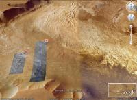
QUOTE (charborob @ Mar 3 2010, 03:28 PM) Could you post a vertical view of the area showing the camera path? I've added the path manually in photoshop so its not 100% accurate. I'll try and get the software to automatically generate this kind of thing for future animations. Path The animation starts bottom left. |
|
|
|
|
Mar 5 2010, 07:44 PM
Post
#35
|
|
|
Senior Member Group: Members Posts: 1074 Joined: 21-September 07 From: Québec, Canada Member No.: 3908 |
Thanks a lot for the path! That's exactly what I was hoping for.
An idea just jumped into my mind. What if you added in a corner of your flyovers a vertical view of the area showing the path travelled and a moving dot indicating the camera location? A bit like what we see in computer games. This is just a suggestion. It may not be easily feasible, and I can't even imagine the work needed already to create your flyovers, so don't think that I want to lay a burden on you, especially since I am a complete ignorant on the subject. |
|
|
|
|
Mar 9 2010, 06:30 AM
Post
#36
|
|
|
Junior Member Group: Members Posts: 37 Joined: 26-January 10 From: Reading, UK Member No.: 5192 |
QUOTE (charborob @ Mar 5 2010, 07:44 PM) An idea just jumped into my mind. What if you added in a corner of your flyovers a vertical view of the area showing the path travelled and a moving dot indicating the camera location? A bit like what we see in computer games. I've added that now. I'm not sure if I'll show it in future animations but its a nice feature to have. |
|
|
|
|
Mar 9 2010, 09:41 PM
Post
#37
|
|
|
Senior Member Group: Moderator Posts: 4279 Joined: 19-April 05 From: .br at .es Member No.: 253 |
I have only now seen this last animation, after checking the latest entry on Emily's blog (Unbelievably spectacular flight through Candor Chasma) and I truly think that such title is 100% right! It's an incredible experience.
(Doug, we should include additional emoticons to the editor; I was looking for one meaning "jaw on the floor" but couldn't find it) |
|
|
|
|
Mar 10 2010, 07:20 AM
Post
#38
|
|
|
Senior Member Group: Members Posts: 2088 Joined: 13-February 10 From: Ontario Member No.: 5221 |
QUOTE (Tesheiner @ Mar 9 2010, 01:41 PM) (Doug, we should include additional emoticons to the editor; I was looking for one meaning "jaw on the floor" but couldn't find it) I think this one expressed me perfectly when I saw that video: [attachment=20997:emot_parrot.gif] I half-thought about using it as an avatar, but I figured it's rather distracting. |
|
|
|
|
Mar 21 2010, 07:24 AM
Post
#39
|
|
|
Junior Member Group: Members Posts: 37 Joined: 26-January 10 From: Reading, UK Member No.: 5192 |
Heres some new animations:
Olympus Mons Basal Scarp http://www.youtube.com/watch?v=LcS_dftaE5U produced from this data http://hirise.lpl.arizona.edu/dtm/dtm.php?ID=PSP_001432_2015 Eberswalde crater inverted channel http://www.youtube.com/watch?v=pc0Kz12bTPw Eberswalde crater moutain http://www.youtube.com/watch?v=omLZdswu44U These two animations were produced from the data here http://hirise.lpl.arizona.edu/dtm/dtm.php?ID=PSP_008272_1560. I am probably outside the MSL landing elipse with those animations but I am just picking the interesting scenery I can now produce youtube animations in analygraph 3d using youtubes new 3d feature. This is just a test video of candor chasma to see if it works. You'll need the coloured glasses to see the 3d effect. http://www.youtube.com/watch?v=02gwaCcsBwQ |
|
|
|
|
Mar 21 2010, 10:03 AM
Post
#40
|
|
|
Dublin Correspondent Group: Admin Posts: 1799 Joined: 28-March 05 From: Celbridge, Ireland Member No.: 220 |
Incredible, you've stepped things up from the previous animations quite significantly. I love the FOV\context map and the altitude\speed indicators, they really help put everything in context. I've always wanted to wander around the Olympus Mons Basal Scarp but I never thought it would be as dramatic as this.
Pure gold. |
|
|
|
|
Mar 21 2010, 07:46 PM
Post
#41
|
|
|
Merciless Robot Group: Admin Posts: 8784 Joined: 8-December 05 From: Los Angeles Member No.: 602 |
 Jeez, what else is there to say? These are spellbinding to watch. Thanks!!! -------------------- A few will take this knowledge and use this power of a dream realized as a force for change, an impetus for further discovery to make less ancient dreams real.
|
|
|
|
|
Mar 21 2010, 09:55 PM
Post
#42
|
||||
 Senior Member Group: Members Posts: 1643 Joined: 5-March 05 From: Boulder, CO Member No.: 184 |
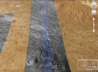
Amazing earlier animation of Candor Chasma - looks like being there, somewhat like parts of Utah. I looked on Google Mars to try and get some context for where this is:
I wonder if more images and DEMS will eventually be available in this area? -------------------- Steve [ my home page and planetary maps page ]
|
|||
|
|
|
|||
 |

|
Lo-Fi Version | Time is now: 3rd June 2024 - 10:26 PM |
|
RULES AND GUIDELINES Please read the Forum Rules and Guidelines before posting. IMAGE COPYRIGHT |
OPINIONS AND MODERATION Opinions expressed on UnmannedSpaceflight.com are those of the individual posters and do not necessarily reflect the opinions of UnmannedSpaceflight.com or The Planetary Society. The all-volunteer UnmannedSpaceflight.com moderation team is wholly independent of The Planetary Society. The Planetary Society has no influence over decisions made by the UnmannedSpaceflight.com moderators. |
SUPPORT THE FORUM Unmannedspaceflight.com is funded by the Planetary Society. Please consider supporting our work and many other projects by donating to the Society or becoming a member. |
|