Paolo's Plunge, First dip into Victoria |

Paolo's Plunge, First dip into Victoria |
 Sep 11 2007, 07:53 AM Sep 11 2007, 07:53 AM
Post
#1
|
|
|
Senior Member  Group: Moderator Posts: 4279 Joined: 19-April 05 From: .br at .es Member No.: 253 |
Hi all,
Like every morning, I've just checked the latest info on the pancam web looking for the current and immediate future imaging plan and ... Stay tuned and start Alt-F5'ing the exploratorium page at 19:35 UTC or so because today might be the day. Sol 1291 is a driving sol! 
|
 |
 
|
 |
|
Sep 16 2007, 06:39 PM
Post
#2
|
|
 Senior Member Group: Members Posts: 2228 Joined: 1-December 04 From: Marble Falls, Texas, USA Member No.: 116 |
As far as I can tell, the most we know about where Opportunity will go and what she will investigate comes from this Aviation Week article. They point out that, after the toe dip...
QUOTE The plan is for the rover, heading south, to then drive 100 ft. into the crater. This will take several days. It will then be commanded tens of meters parallel along the crater wall. The objective will be to reach about a 1-meter-thick white rock layer that cuts through the wall of the entire crater--but at a point where it's easily sampled, not where it's also visible in the high promontories. I can't see how they can travel parallel to the light band of rock for tens of meters unless Opportunity turns to the south to follow it across the bay.I think the article also makes clear the initial scientific objective. QUOTE With Victoria, "we will really be making the first good vertical slice through an impact ejecta blanket and crater walls on another planet," says Squyres. Then they go on to say...QUOTE This is the original Martian surface layer before the meteorite hit, burying and preserving the layer that was originally directly exposed to the Martian environment. At a minimum, the area is expected to provide direct data on the Martian climate billions of years ago. And even more, it could be (the) "bathtub ring," showing the Martin surface or ground water level at the time. If it's a surface or ground water signature, it will be important to Martian life assessments.
-------------------- ...Tom
I'm not a Space Fan, I'm a Space Exploration Enthusiast. |
|
|
|
|
Sep 19 2007, 03:38 PM
Post
#3
|
||
 Senior Member Group: Members Posts: 4251 Joined: 17-January 05 Member No.: 152 |
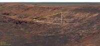
QUOTE (CosmicRocker @ Sep 16 2007, 06:39 PM)  I can't see how they can travel parallel to the light band of rock for tens of meters unless Opportunity turns to the south to follow it across the bay. I agree with Rocker here. This is the route that makes the most sense, by keeping away from the cliffs and sampling the best defined part of the white layer (at the end of the arrows in my image). From Alan's map, here are two possible routes, the white was my initial guess, but the yellow is a possibility based on the drive direction imagery Tesheiner pointed to:
Or, you never know, since they're driving downhill, maybe they'll drive straight through the patch of sand in front of us! |
|
|
|
|
|
 Tesheiner Paolo's Plunge Sep 11 2007, 07:53 AM
 jamescanvin I think your right Tesh.
This line is telling:
C... Sep 11 2007, 09:35 AM Stu Not going to make a huge deal out of it... many mo... Sep 11 2007, 09:42 AM
jamescanvin I think your right Tesh.
This line is telling:
C... Sep 11 2007, 09:35 AM Stu Not going to make a huge deal out of it... many mo... Sep 11 2007, 09:42 AM
 sattrackpro QUOTE (Stu @ Sep 11 2007, 02:42 AM) ...I ... Sep 11 2007, 01:21 PM Del Palmer QUOTE (sattrackpro @ Sep 11 2007, 02:21 P... Sep 11 2007, 03:58 PM OWW That's a picture from Spirit. Sep 11 2007, 09:58 AM Stu I know it is, thanks, but both rovers carry a pie... Sep 11 2007, 10:03 AM ElkGroveDan The WTC metal is the plate attached to the back of... Sep 11 2007, 02:04 PM Stu Yep, that's the one, as labelled on the pic in... Sep 11 2007, 02:20 PM Tesheiner QUOTE (DEChengst @ Sep 11 2007, 09:45 PM)... Sep 11 2007, 08:15 PM BrianL Looks that way to me too, and makes sense to test ... Sep 11 2007, 08:32 PM mhoward It looks like the drift is not an issue. That... Sep 11 2007, 08:44 PM Tman Yeah, though it seems Oppy got a bit slippage whil... Sep 11 2007, 08:53 PM Tesheiner A clean path right ahead!
May I call this m... Sep 11 2007, 08:57 PM Indian3000 and my version
and vertial projection
Sep 11 2007, 09:14 PM Indian3000 and a other 360° projection with front and rear ca... Sep 11 2007, 09:30 PM hortonheardawho sol 1291 R0 1x3:
L0 1x3 here
All the images ... Sep 11 2007, 09:30 PM jamescanvin You know, I think we may have gone further in than... Sep 11 2007, 10:01 PM mhoward I can't wait to get a look at that tracking da... Sep 11 2007, 11:06 PM alan Mars rover begins risky downward drive
Opportunity... Sep 12 2007, 12:10 AM mhoward QUOTE (alan @ Sep 12 2007, 12:10 AM) http... Sep 12 2007, 12:51 AM mhoward I don't know how accurate the tracking data is... Sep 12 2007, 12:56 AM mhoward On closer inspection, I agree it looks like there ... Sep 12 2007, 01:42 AM mhoward Ah, looks like the news is already here. That... Sep 12 2007, 02:20 AM CosmicRocker QUOTE (Stu @ Sep 11 2007, 04:42 AM) Not g... Sep 12 2007, 04:29 AM Geographer Damn, these freakin' rovers!! They pu... Sep 12 2007, 07:23 AM mhoward Here's a little video of Paolo's Plunge, a... Sep 13 2007, 03:31 AM Tesheiner Ok. Sol 1291 was the day in which Opportunity move... Sep 13 2007, 08:19 AM jamescanvin Because of Iapetus I still haven't got a dust ... Sep 13 2007, 01:19 PM mhoward QUOTE (jamescanvin @ Sep 13 2007, 01:19 P... Sep 13 2007, 01:50 PM Tesheiner QUOTE (jamescanvin @ Sep 13 2007, 03:19 P... Sep 13 2007, 02:28 PM hortonheardawho sol 1291 L257 1x4:
Without at least a 1/3 overl... Sep 13 2007, 02:25 PM SpaceListener How can the entry surface of Duck Bay is so smooth... Sep 13 2007, 03:12 PM climber QUOTE (SpaceListener @ Sep 13 2007, 05:12... Sep 13 2007, 03:45 PM SpaceListener QUOTE (climber @ Sep 13 2007, 10:45 AM) E... Sep 13 2007, 08:18 PM stevesliva The smoothness of the bays versus the boulder-stre... Sep 13 2007, 05:17 PM kenny We discussed this issue, the apparently planed smo... Sep 13 2007, 08:41 PM dburt An alternative hypothesis for Victoria is that the... Sep 13 2007, 08:42 PM .dk We are inside!
http://nasa.exploratorium.edu... Sep 13 2007, 08:57 PM Indian3000 sol 1293
Sep 13 2007, 09:38 PM WindyT QUOTE (Indian3000 @ Sep 13 2007, 09:38 PM... Sep 13 2007, 10:36 PM djellison A bit of photoshop, a lot of MMB..the view of the ... Sep 13 2007, 09:39 PM Indian3000 and front rear cam 360°
Sep 13 2007, 09:40 PM Indian3000 a manual merge between panorama sol 1291 and sol 1... Sep 14 2007, 06:49 AM Tesheiner What about the slope angle?
What I've got from... Sep 14 2007, 07:58 AM djellison I call this one... dip and dive Sep 14 2007, 12:21 PM mhoward QUOTE (djellison @ Sep 14 2007, 12:21 PM)... Sep 14 2007, 04:45 PM jamescanvin Ooh, I'm liking that one Doug.
I've... Sep 14 2007, 01:29 PM jvandriel For the computer guys,
is it possible to make and... Sep 14 2007, 09:01 PM alan Current Location
Original image can be found her... Sep 15 2007, 02:09 AM ElkGroveDan QUOTE (alan @ Sep 14 2007, 06:09 PM) Curr... Sep 15 2007, 03:18 AM alan I wonder how they will maneuver Oppy around the pa... Sep 15 2007, 02:45 AM CosmicRocker QUOTE (Tesheiner @ Sep 14 2007, 02:58 AM)... Sep 15 2007, 03:54 AM dvandorn I thought the plan was to turn to Oppy's left ... Sep 15 2007, 05:39 AM CosmicRocker O'Doug: It was my recollection that the plan ... Sep 15 2007, 12:49 PM jvandriel Here is the view from Sol 1293 taken inside Victor... Sep 15 2007, 01:27 PM Tesheiner By the moment I think they will drive almost strai... Sep 15 2007, 01:28 PM SpaceListener After studying the Jvandriel's picture to prec... Sep 15 2007, 05:01 PM glennwsmith Yes, Alan, nice work. A good complement to Teshei... Sep 15 2007, 05:01 PM dvandorn I've revisited the late June and early July di... Sep 16 2007, 06:07 AM ElkGroveDan QUOTE (dvandorn @ Sep 15 2007, 10:07 PM) ... Sep 16 2007, 05:10 PM djellison But it was also mentioned that they wouldn't g... Sep 16 2007, 07:32 AM Oersted Ah, I'm sure the intrepid rover team will mana... Sep 16 2007, 08:31 AM fredk Thanks a lot for the entry location map, Alan. If... Sep 16 2007, 10:47 PM mhoward Here are a couple similar MMB views based on the d... Sep 16 2007, 11:32 PM Tesheiner Still on the issue of "which will be the next... Sep 17 2007, 10:58 AM Bobby No new images from The Exploratorium web site sinc... Sep 17 2007, 06:30 PM Sunspot QUOTE (Bobby @ Sep 17 2007, 07:30 PM) No ... Sep 17 2007, 06:39 PM djellison CODE0874331189:8 2007-258T13:40:54 ci2... Sep 17 2007, 06:40 PM OWW QUOTE (djellison @ Sep 17 2007, 06:40 PM)... Sep 17 2007, 08:29 PM djellison Oops - yup - I did
Doug Sep 17 2007, 09:12 PM Sunspot Are power levels still too low to permit direct tr... Sep 18 2007, 09:16 AM djellison They could probably do short DTE sessions, but is ... Sep 18 2007, 09:29 AM mhoward Here's another little experimental movie of th... Sep 19 2007, 04:07 AM slinted QUOTE (mhoward @ Sep 18 2007, 09:07 PM) H... Sep 19 2007, 04:30 AM PhilCo126 great movie mhoward Sep 19 2007, 05:42 PM nprev Terrific movie, MHoward!!!
Here... Sep 19 2007, 11:38 PM fredk New images in! On sol 1298 we seem to have ar... Sep 20 2007, 01:48 AM CosmicRocker mhoward: That animation was amazing. Really amaz... Sep 20 2007, 04:06 AM dilo Here a stitch from two left NavCam frames availabl... Sep 20 2007, 05:10 AM Astro0 I thought it might be useful to create a composite... Sep 20 2007, 06:47 AM Sunspot I wonder if they are heading for the arrow shaped ... Sep 20 2007, 08:34 AM Tesheiner I would say so, because the driving manouver ended... Sep 20 2007, 08:51 AM ilbasso Here's my guess Sep 20 2007, 01:13 PM Tesheiner Right on the money! Sep 20 2007, 01:58 PM jamescanvin Quick stitch of the sol 1298 drive direction mosai... Sep 21 2007, 11:18 AM algorimancer QUOTE (jamescanvin @ Sep 21 2007, 06:18 A... Sep 21 2007, 12:51 PM TheChemist This looks like Endurance, minus one detail: the b... Sep 21 2007, 12:29 PM Del Palmer QUOTE (TheChemist @ Sep 21 2007, 12:29 PM... Sep 21 2007, 01:58 PM djellison Hunt down Steve's lecture to the Open Universi... Sep 21 2007, 12:45 PM helvick If Oppy is currently "above where the berries... Sep 21 2007, 01:30 PM djellison Just remembering an early interpretation of the be... Sep 21 2007, 01:48 PM TheChemist Thanks Doug, I remember I watched that at the time... Sep 21 2007, 02:02 PM climber I don't know whether we should be surprised or... Sep 21 2007, 04:27 PM Floyd The layer above the white layer is just jumbled ej... Sep 21 2007, 07:43 PM alan This is the first time they've had an opportun... Sep 21 2007, 07:55 PM Shaka I agree that the ejecta layer is worth studying, b... Sep 21 2007, 08:45 PM ElkGroveDan I agree with Shaka. Sep 21 2007, 08:48 PM
sattrackpro QUOTE (Stu @ Sep 11 2007, 02:42 AM) ...I ... Sep 11 2007, 01:21 PM Del Palmer QUOTE (sattrackpro @ Sep 11 2007, 02:21 P... Sep 11 2007, 03:58 PM OWW That's a picture from Spirit. Sep 11 2007, 09:58 AM Stu I know it is, thanks, but both rovers carry a pie... Sep 11 2007, 10:03 AM ElkGroveDan The WTC metal is the plate attached to the back of... Sep 11 2007, 02:04 PM Stu Yep, that's the one, as labelled on the pic in... Sep 11 2007, 02:20 PM Tesheiner QUOTE (DEChengst @ Sep 11 2007, 09:45 PM)... Sep 11 2007, 08:15 PM BrianL Looks that way to me too, and makes sense to test ... Sep 11 2007, 08:32 PM mhoward It looks like the drift is not an issue. That... Sep 11 2007, 08:44 PM Tman Yeah, though it seems Oppy got a bit slippage whil... Sep 11 2007, 08:53 PM Tesheiner A clean path right ahead!
May I call this m... Sep 11 2007, 08:57 PM Indian3000 and my version
and vertial projection
Sep 11 2007, 09:14 PM Indian3000 and a other 360° projection with front and rear ca... Sep 11 2007, 09:30 PM hortonheardawho sol 1291 R0 1x3:
L0 1x3 here
All the images ... Sep 11 2007, 09:30 PM jamescanvin You know, I think we may have gone further in than... Sep 11 2007, 10:01 PM mhoward I can't wait to get a look at that tracking da... Sep 11 2007, 11:06 PM alan Mars rover begins risky downward drive
Opportunity... Sep 12 2007, 12:10 AM mhoward QUOTE (alan @ Sep 12 2007, 12:10 AM) http... Sep 12 2007, 12:51 AM mhoward I don't know how accurate the tracking data is... Sep 12 2007, 12:56 AM mhoward On closer inspection, I agree it looks like there ... Sep 12 2007, 01:42 AM mhoward Ah, looks like the news is already here. That... Sep 12 2007, 02:20 AM CosmicRocker QUOTE (Stu @ Sep 11 2007, 04:42 AM) Not g... Sep 12 2007, 04:29 AM Geographer Damn, these freakin' rovers!! They pu... Sep 12 2007, 07:23 AM mhoward Here's a little video of Paolo's Plunge, a... Sep 13 2007, 03:31 AM Tesheiner Ok. Sol 1291 was the day in which Opportunity move... Sep 13 2007, 08:19 AM jamescanvin Because of Iapetus I still haven't got a dust ... Sep 13 2007, 01:19 PM mhoward QUOTE (jamescanvin @ Sep 13 2007, 01:19 P... Sep 13 2007, 01:50 PM Tesheiner QUOTE (jamescanvin @ Sep 13 2007, 03:19 P... Sep 13 2007, 02:28 PM hortonheardawho sol 1291 L257 1x4:
Without at least a 1/3 overl... Sep 13 2007, 02:25 PM SpaceListener How can the entry surface of Duck Bay is so smooth... Sep 13 2007, 03:12 PM climber QUOTE (SpaceListener @ Sep 13 2007, 05:12... Sep 13 2007, 03:45 PM SpaceListener QUOTE (climber @ Sep 13 2007, 10:45 AM) E... Sep 13 2007, 08:18 PM stevesliva The smoothness of the bays versus the boulder-stre... Sep 13 2007, 05:17 PM kenny We discussed this issue, the apparently planed smo... Sep 13 2007, 08:41 PM dburt An alternative hypothesis for Victoria is that the... Sep 13 2007, 08:42 PM .dk We are inside!
http://nasa.exploratorium.edu... Sep 13 2007, 08:57 PM Indian3000 sol 1293
Sep 13 2007, 09:38 PM WindyT QUOTE (Indian3000 @ Sep 13 2007, 09:38 PM... Sep 13 2007, 10:36 PM djellison A bit of photoshop, a lot of MMB..the view of the ... Sep 13 2007, 09:39 PM Indian3000 and front rear cam 360°
Sep 13 2007, 09:40 PM Indian3000 a manual merge between panorama sol 1291 and sol 1... Sep 14 2007, 06:49 AM Tesheiner What about the slope angle?
What I've got from... Sep 14 2007, 07:58 AM djellison I call this one... dip and dive Sep 14 2007, 12:21 PM mhoward QUOTE (djellison @ Sep 14 2007, 12:21 PM)... Sep 14 2007, 04:45 PM jamescanvin Ooh, I'm liking that one Doug.
I've... Sep 14 2007, 01:29 PM jvandriel For the computer guys,
is it possible to make and... Sep 14 2007, 09:01 PM alan Current Location
Original image can be found her... Sep 15 2007, 02:09 AM ElkGroveDan QUOTE (alan @ Sep 14 2007, 06:09 PM) Curr... Sep 15 2007, 03:18 AM alan I wonder how they will maneuver Oppy around the pa... Sep 15 2007, 02:45 AM CosmicRocker QUOTE (Tesheiner @ Sep 14 2007, 02:58 AM)... Sep 15 2007, 03:54 AM dvandorn I thought the plan was to turn to Oppy's left ... Sep 15 2007, 05:39 AM CosmicRocker O'Doug: It was my recollection that the plan ... Sep 15 2007, 12:49 PM jvandriel Here is the view from Sol 1293 taken inside Victor... Sep 15 2007, 01:27 PM Tesheiner By the moment I think they will drive almost strai... Sep 15 2007, 01:28 PM SpaceListener After studying the Jvandriel's picture to prec... Sep 15 2007, 05:01 PM glennwsmith Yes, Alan, nice work. A good complement to Teshei... Sep 15 2007, 05:01 PM dvandorn I've revisited the late June and early July di... Sep 16 2007, 06:07 AM ElkGroveDan QUOTE (dvandorn @ Sep 15 2007, 10:07 PM) ... Sep 16 2007, 05:10 PM djellison But it was also mentioned that they wouldn't g... Sep 16 2007, 07:32 AM Oersted Ah, I'm sure the intrepid rover team will mana... Sep 16 2007, 08:31 AM fredk Thanks a lot for the entry location map, Alan. If... Sep 16 2007, 10:47 PM mhoward Here are a couple similar MMB views based on the d... Sep 16 2007, 11:32 PM Tesheiner Still on the issue of "which will be the next... Sep 17 2007, 10:58 AM Bobby No new images from The Exploratorium web site sinc... Sep 17 2007, 06:30 PM Sunspot QUOTE (Bobby @ Sep 17 2007, 07:30 PM) No ... Sep 17 2007, 06:39 PM djellison CODE0874331189:8 2007-258T13:40:54 ci2... Sep 17 2007, 06:40 PM OWW QUOTE (djellison @ Sep 17 2007, 06:40 PM)... Sep 17 2007, 08:29 PM djellison Oops - yup - I did
Doug Sep 17 2007, 09:12 PM Sunspot Are power levels still too low to permit direct tr... Sep 18 2007, 09:16 AM djellison They could probably do short DTE sessions, but is ... Sep 18 2007, 09:29 AM mhoward Here's another little experimental movie of th... Sep 19 2007, 04:07 AM slinted QUOTE (mhoward @ Sep 18 2007, 09:07 PM) H... Sep 19 2007, 04:30 AM PhilCo126 great movie mhoward Sep 19 2007, 05:42 PM nprev Terrific movie, MHoward!!!
Here... Sep 19 2007, 11:38 PM fredk New images in! On sol 1298 we seem to have ar... Sep 20 2007, 01:48 AM CosmicRocker mhoward: That animation was amazing. Really amaz... Sep 20 2007, 04:06 AM dilo Here a stitch from two left NavCam frames availabl... Sep 20 2007, 05:10 AM Astro0 I thought it might be useful to create a composite... Sep 20 2007, 06:47 AM Sunspot I wonder if they are heading for the arrow shaped ... Sep 20 2007, 08:34 AM Tesheiner I would say so, because the driving manouver ended... Sep 20 2007, 08:51 AM ilbasso Here's my guess Sep 20 2007, 01:13 PM Tesheiner Right on the money! Sep 20 2007, 01:58 PM jamescanvin Quick stitch of the sol 1298 drive direction mosai... Sep 21 2007, 11:18 AM algorimancer QUOTE (jamescanvin @ Sep 21 2007, 06:18 A... Sep 21 2007, 12:51 PM TheChemist This looks like Endurance, minus one detail: the b... Sep 21 2007, 12:29 PM Del Palmer QUOTE (TheChemist @ Sep 21 2007, 12:29 PM... Sep 21 2007, 01:58 PM djellison Hunt down Steve's lecture to the Open Universi... Sep 21 2007, 12:45 PM helvick If Oppy is currently "above where the berries... Sep 21 2007, 01:30 PM djellison Just remembering an early interpretation of the be... Sep 21 2007, 01:48 PM TheChemist Thanks Doug, I remember I watched that at the time... Sep 21 2007, 02:02 PM climber I don't know whether we should be surprised or... Sep 21 2007, 04:27 PM Floyd The layer above the white layer is just jumbled ej... Sep 21 2007, 07:43 PM alan This is the first time they've had an opportun... Sep 21 2007, 07:55 PM Shaka I agree that the ejecta layer is worth studying, b... Sep 21 2007, 08:45 PM ElkGroveDan I agree with Shaka. Sep 21 2007, 08:48 PM |

|
Lo-Fi Version | Time is now: 5th June 2024 - 04:32 PM |
|
RULES AND GUIDELINES Please read the Forum Rules and Guidelines before posting. IMAGE COPYRIGHT |
OPINIONS AND MODERATION Opinions expressed on UnmannedSpaceflight.com are those of the individual posters and do not necessarily reflect the opinions of UnmannedSpaceflight.com or The Planetary Society. The all-volunteer UnmannedSpaceflight.com moderation team is wholly independent of The Planetary Society. The Planetary Society has no influence over decisions made by the UnmannedSpaceflight.com moderators. |
SUPPORT THE FORUM Unmannedspaceflight.com is funded by the Planetary Society. Please consider supporting our work and many other projects by donating to the Society or becoming a member. |
|