Google Lunar X Prize |

Google Lunar X Prize |
 Mar 28 2008, 08:53 PM Mar 28 2008, 08:53 PM
Post
#1
|
|
|
Solar System Cartographer  Group: Members Posts: 10226 Joined: 5-April 05 From: Canada Member No.: 227 |
Am I completely out of it, or is there no GLXP thread on here? I couldn't find one. Anyway, things are moving on it, so I thought we ought to have one.
For the record, I just turned down my second invitation to join a team. I'm staying as an interested observer on this - for now, anyway. There is a forum at the GLXP site as well as team info. There are a lot of people with half-baked ideas of how to go about it. The real professionals are not doing much on the forum, just working behind the scenes. At LPSC two weeks ago, Bob Richards of Odyssey Moon invited people to propose instruments to carry on their rover - targeted to a pyroclastic deposit, probably Rima Bode or Sulpicius Gallus. And I see they have now signed an agreement to carry Celestis's lunar burials to the Moon. Richards will be here next week, and I'll be spending some time with him. This whole thing is going to be interesting. Phil -------------------- ... because the Solar System ain't gonna map itself.
Also to be found posting similar content on https://mastodon.social/@PhilStooke Maps for download (free PDF: https://upload.wikimedia.org/wikipedia/comm...Cartography.pdf NOTE: everything created by me which I post on UMSF is considered to be in the public domain (NOT CC, public domain) |
 |
 
|
 |
|
Apr 11 2008, 04:38 PM
Post
#2
|
||
|
Solar System Cartographer Group: Members Posts: 10226 Joined: 5-April 05 From: Canada Member No.: 227 |
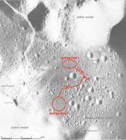
I've been thinking about the Google Lunar X Prize in the context of protecting historic sites. Transorbital, Inc. had to guarantee its end-of-mission impact (for the Trailblazer orbiter) would not harm old sites, as a condition of getting government licenses to fly the mission. GLXP specifically encourages people to land close to and visit old sites. Are these incompatible?
I have made this map of the Apollo 17 site to suggest otherwise. A rover could land in one of two relatively smooth areas near the LM and drive to within a few tens of meters of the LM (and the ALSEP just to its west) without even crossing old LRV tracks and footprints. A very accurate landing system could find landing sites just SW or N of the LM and be within the GLXP minimum traverse distance of 500 m as well. I argue that most or all teams will need sponsorships and potential sponsors will not want the bad publicity that would come from and damage to the sites - purists might interpret that as including driving over old footprints. Phil
-------------------- ... because the Solar System ain't gonna map itself.
Also to be found posting similar content on https://mastodon.social/@PhilStooke Maps for download (free PDF: https://upload.wikimedia.org/wikipedia/comm...Cartography.pdf NOTE: everything created by me which I post on UMSF is considered to be in the public domain (NOT CC, public domain) |
|
|
|
|
|
 Phil Stooke Google Lunar X Prize Mar 28 2008, 08:53 PM
 djellison I remember discussing it - but it must have been e... Mar 28 2008, 09:26 PM ugordan QUOTE (Phil Stooke @ Mar 28 2008, 09:53 P... Mar 28 2008, 09:30 PM Stu Excellent post, and excellent work Phil. Preservin... Apr 11 2008, 06:53 PM Betelgeuze Also the moon is so big, why land on a place weve ... Apr 11 2008, 09:11 PM
 climber QUOTE (Betelgeuze @ Apr 11 2008, 11:11 PM... Apr 11 2008, 09:18 PM
 Stu QUOTE (Betelgeuze @ Apr 11 2008, 10:11 PM... Apr 12 2008, 07:28 AM nprev QUOTE (Stu @ Apr 12 2008, 12:28 AM) In th... Apr 12 2008, 01:13 PM imipak QUOTE (nprev @ Apr 12 2008, 01:13 PM) Nei... Apr 12 2008, 02:41 PM mcaplinger QUOTE (imipak @ Apr 12 2008, 06:41 AM) An... Apr 12 2008, 07:05 PM JRehling QUOTE (mcaplinger @ Apr 12 2008, 11:05 AM... Apr 15 2008, 03:29 AM Betelgeuze Not sure I understand what you mean with that.
Wh... Apr 11 2008, 11:17 PM stevesliva QUOTE (Betelgeuze @ Apr 11 2008, 07:17 PM... Apr 11 2008, 11:53 PM djellison There's the whole of antarctica to visit - so ... Apr 11 2008, 11:30 PM ElkGroveDan It kind of makes you wonder how in the future such... Apr 11 2008, 11:38 PM Phil Stooke An even better reason than 'because it's t... Apr 11 2008, 11:50 PM Betelgeuze 1969 Is not that long ago (heh and I'm only 21... Apr 12 2008, 03:36 PM Stu QUOTE (Betelgeuze @ Apr 12 2008, 04:36 PM... Apr 12 2008, 08:32 PM Betelgeuze If pictures and movies from 1969 don't inspire... Apr 12 2008, 10:47 PM Greg Hullender QUOTE (Betelgeuze @ Apr 12 2008, 03:47 PM... Apr 13 2008, 12:10 AM Stu QUOTE (Greg Hullender @ Apr 13 2008, 01:1... Apr 13 2008, 07:07 AM Greg Hullender QUOTE (Stu @ Apr 12 2008, 11:07 PM) I hav... Apr 13 2008, 03:25 PM Stu QUOTE (Betelgeuze @ Apr 12 2008, 11:47 PM... Apr 13 2008, 07:28 AM JRehling QUOTE (Stu @ Apr 12 2008, 12:32 PM) And t... Apr 15 2008, 03:41 AM Greg Hullender QUOTE (JRehling @ Apr 14 2008, 08:41 PM) ... Apr 15 2008, 04:55 AM Phil Stooke I think this is missing the point. Look at Astrob... Apr 12 2008, 04:13 PM Phil Stooke It's not about making money - nor was the Ansa... Apr 12 2008, 08:23 PM mcaplinger QUOTE (Phil Stooke @ Apr 12 2008, 01:23 P... Apr 12 2008, 11:12 PM Betelgeuze I've never been in front of a classroom talkin... Apr 13 2008, 11:18 AM djellison QUOTE (Betelgeuze @ Apr 13 2008, 12:18 PM... Apr 13 2008, 11:29 AM ugordan QUOTE (Betelgeuze @ Apr 13 2008, 01:18 PM... Apr 13 2008, 11:36 AM Stu QUOTE (Betelgeuze @ Apr 13 2008, 12:18 PM... Apr 13 2008, 11:48 AM djellison If you want to have a slap fight about education -... Apr 14 2008, 07:04 AM Phil Stooke I've made a map showing the various places on ... May 3 2008, 04:57 PM nprev NOT liking the "Tranquility Trek", Astro... May 3 2008, 05:06 PM Phil Stooke The disturbance issue is going to be big, and I... May 3 2008, 05:18 PM nprev Glad to hear this, Phil. One other constraint must... May 3 2008, 05:22 PM Phil Stooke The landing ellipse issue is very important, and I... May 3 2008, 05:25 PM nprev Well, I'd concede that the lack of atmosphere ... May 3 2008, 05:30 PM tedstryk I would agree that I would hate to see an x-prize ... May 3 2008, 11:05 PM nprev QUOTE (tedstryk @ May 3 2008, 04:05 PM) I... May 4 2008, 03:08 AM Stu Here's an idea: you disturb ANYTHING at Tranqu... May 3 2008, 11:06 PM djellison QUOTE (Stu @ May 4 2008, 12:06 AM) Or hac... May 3 2008, 11:29 PM Stu QUOTE (djellison @ May 4 2008, 12:29 AM) ... May 3 2008, 11:37 PM nprev QUOTE (djellison @ May 3 2008, 03:29 PM) ... May 3 2008, 11:44 PM Stu Here's an interesting tidbit... was quite amaz... May 3 2008, 11:49 PM Phil Stooke People who care about the protection of these site... May 4 2008, 12:10 AM Stu On the Google Lunar X-Prize website, a YouTube vid... May 4 2008, 09:38 AM Astroblogger QUOTE (Stu @ May 4 2008, 09:38 AM) On the... Jun 18 2008, 03:22 PM nprev Yeah...esp. with that little robot-vacuum-cleaner-... May 4 2008, 12:13 PM Stu I'm going to make Preserving Tranquility Base ... May 4 2008, 12:27 PM ilbasso This article on Space.com discusses how difficult ... May 5 2008, 02:23 AM nprev Jeez... ...thanks, ILB!
I'm sure that no... May 5 2008, 10:35 AM ugordan QUOTE (nprev @ May 5 2008, 12:35 PM) I... May 5 2008, 11:57 AM nprev QUOTE (ugordan @ May 5 2008, 04:57 AM) Al... May 5 2008, 12:35 PM tedstryk Knowing luck, we will take all sorts of drastic me... May 5 2008, 12:41 PM Stu Looks like others feel the same about preserving T... May 5 2008, 03:33 PM jasedm I'm 100% behind the principle of preserving th... May 6 2008, 01:31 PM Stu Sadly, I'm 100000% certain that you're rig... May 6 2008, 01:49 PM imipak QUOTE (Stu @ May 6 2008, 02:49 PM) But th... May 6 2008, 07:37 PM Stu QUOTE (imipak @ May 6 2008, 08:37 PM) but... May 6 2008, 09:29 PM mcaplinger QUOTE (Stu @ May 6 2008, 02:29 PM) Astrob... May 6 2008, 11:02 PM DDAVIS “To destroy the relics of the past is, even ... May 10 2008, 09:21 PM Stu Good point, but it does suggest an element of ... May 7 2008, 05:27 AM imipak Full inline quote removed. - Doug.
It does; but i... May 7 2008, 06:49 PM Phil Stooke No, imipak, several hundred million dollars is way... May 7 2008, 07:46 PM tedstryk What is the other one? May 8 2008, 01:16 AM imipak QUOTE (Phil Stooke @ May 7 2008, 08:46 PM... May 8 2008, 07:23 PM Phil Stooke I'm not saying! Can't afford to alien... May 8 2008, 02:16 AM Phil Stooke "I still don't see how it can be done wit... May 8 2008, 07:57 PM tedstryk QUOTE (Phil Stooke @ May 8 2008, 07:57 PM... May 8 2008, 08:12 PM nprev Very good point really in your last, Don. Why the ... May 10 2008, 11:42 PM Phil Stooke That is exactly the rationale of Odyssey Moon.
Ph... May 11 2008, 07:55 PM nprev I wish them luck; seems as if my opinions & th... May 11 2008, 08:29 PM Betelgeuze heh nprev thats the point I've been trying to ... May 11 2008, 10:23 PM nprev If you're referring to this post, then, yeah, ... May 11 2008, 10:53 PM dvandorn Yeah, but... I have this image of Buzz Aldrin, in... May 12 2008, 12:20 AM nprev Okay, NOW I have to go get my brain flashburned to... May 12 2008, 12:26 AM dvandorn You can always add to that "Poor Neil -- he d... May 12 2008, 01:45 AM nprev <removes creaking 386 space-certified processor... May 12 2008, 01:59 AM Mongo Here is photographic evidence that the Apollo 11 l... May 13 2008, 01:35 AM nprev Hey...nobody saw me, you can't prove anything,... May 13 2008, 01:52 AM Phil Stooke Cease this friviolity at once!
And now for so... May 15 2008, 02:22 PM Stu A terrifying glimpse into the future...?
Salvage ... May 18 2008, 12:25 PM nprev ...now there's a blast from the past! Than... May 18 2008, 12:42 PM Phil Stooke Four new GLXP teams announced, and one new landing... May 23 2008, 11:41 AM SFJCody QUOTE (Phil Stooke @ May 23 2008, 12:41 P... May 23 2008, 04:54 PM DDAVIS QUOTE (SFJCody @ May 23 2008, 04:54 PM) M... May 23 2008, 05:33 PM Phil Stooke ... and then there were 13. One GLXP team has dro... May 25 2008, 12:55 AM Stu Thanks for that, Astroblogger, really appreciate y... Jun 18 2008, 03:40 PM helvick One of our favourite PI's gets involved in the... Jun 18 2008, 08:13 PM Phil Stooke Thanks for this, Astroblogger. This is a very fla... Jun 19 2008, 01:10 AM dvandorn The only thing we need to be reasonably careful of... Jun 19 2008, 04:43 AM PDP8E Here is a map of the Apollo 11 site superimposed o... Jun 20 2008, 03:17 AM Phil Stooke Using some ideas already discussed here - includin... Jul 8 2008, 08:53 PM nprev Looks great, Phil! Very honored by your ack... Jul 8 2008, 09:22 PM dvandorn Very nice, Phil!
Just one caution (and I know... Jul 9 2008, 05:58 AM AndyG Good stuff, Phil. However, I have an issue with th... Jul 9 2008, 09:01 AM Phil Stooke I don't suggest tracks or footprints should be... Jul 9 2008, 11:14 AM
Stu QUOTE (Betelgeuze @ Apr 11 2008, 10:11 PM... Apr 12 2008, 07:28 AM nprev QUOTE (Stu @ Apr 12 2008, 12:28 AM) In th... Apr 12 2008, 01:13 PM imipak QUOTE (nprev @ Apr 12 2008, 01:13 PM) Nei... Apr 12 2008, 02:41 PM mcaplinger QUOTE (imipak @ Apr 12 2008, 06:41 AM) An... Apr 12 2008, 07:05 PM JRehling QUOTE (mcaplinger @ Apr 12 2008, 11:05 AM... Apr 15 2008, 03:29 AM Betelgeuze Not sure I understand what you mean with that.
Wh... Apr 11 2008, 11:17 PM stevesliva QUOTE (Betelgeuze @ Apr 11 2008, 07:17 PM... Apr 11 2008, 11:53 PM djellison There's the whole of antarctica to visit - so ... Apr 11 2008, 11:30 PM ElkGroveDan It kind of makes you wonder how in the future such... Apr 11 2008, 11:38 PM Phil Stooke An even better reason than 'because it's t... Apr 11 2008, 11:50 PM Betelgeuze 1969 Is not that long ago (heh and I'm only 21... Apr 12 2008, 03:36 PM Stu QUOTE (Betelgeuze @ Apr 12 2008, 04:36 PM... Apr 12 2008, 08:32 PM Betelgeuze If pictures and movies from 1969 don't inspire... Apr 12 2008, 10:47 PM Greg Hullender QUOTE (Betelgeuze @ Apr 12 2008, 03:47 PM... Apr 13 2008, 12:10 AM Stu QUOTE (Greg Hullender @ Apr 13 2008, 01:1... Apr 13 2008, 07:07 AM Greg Hullender QUOTE (Stu @ Apr 12 2008, 11:07 PM) I hav... Apr 13 2008, 03:25 PM Stu QUOTE (Betelgeuze @ Apr 12 2008, 11:47 PM... Apr 13 2008, 07:28 AM JRehling QUOTE (Stu @ Apr 12 2008, 12:32 PM) And t... Apr 15 2008, 03:41 AM Greg Hullender QUOTE (JRehling @ Apr 14 2008, 08:41 PM) ... Apr 15 2008, 04:55 AM Phil Stooke I think this is missing the point. Look at Astrob... Apr 12 2008, 04:13 PM Phil Stooke It's not about making money - nor was the Ansa... Apr 12 2008, 08:23 PM mcaplinger QUOTE (Phil Stooke @ Apr 12 2008, 01:23 P... Apr 12 2008, 11:12 PM Betelgeuze I've never been in front of a classroom talkin... Apr 13 2008, 11:18 AM djellison QUOTE (Betelgeuze @ Apr 13 2008, 12:18 PM... Apr 13 2008, 11:29 AM ugordan QUOTE (Betelgeuze @ Apr 13 2008, 01:18 PM... Apr 13 2008, 11:36 AM Stu QUOTE (Betelgeuze @ Apr 13 2008, 12:18 PM... Apr 13 2008, 11:48 AM djellison If you want to have a slap fight about education -... Apr 14 2008, 07:04 AM Phil Stooke I've made a map showing the various places on ... May 3 2008, 04:57 PM nprev NOT liking the "Tranquility Trek", Astro... May 3 2008, 05:06 PM Phil Stooke The disturbance issue is going to be big, and I... May 3 2008, 05:18 PM nprev Glad to hear this, Phil. One other constraint must... May 3 2008, 05:22 PM Phil Stooke The landing ellipse issue is very important, and I... May 3 2008, 05:25 PM nprev Well, I'd concede that the lack of atmosphere ... May 3 2008, 05:30 PM tedstryk I would agree that I would hate to see an x-prize ... May 3 2008, 11:05 PM nprev QUOTE (tedstryk @ May 3 2008, 04:05 PM) I... May 4 2008, 03:08 AM Stu Here's an idea: you disturb ANYTHING at Tranqu... May 3 2008, 11:06 PM djellison QUOTE (Stu @ May 4 2008, 12:06 AM) Or hac... May 3 2008, 11:29 PM Stu QUOTE (djellison @ May 4 2008, 12:29 AM) ... May 3 2008, 11:37 PM nprev QUOTE (djellison @ May 3 2008, 03:29 PM) ... May 3 2008, 11:44 PM Stu Here's an interesting tidbit... was quite amaz... May 3 2008, 11:49 PM Phil Stooke People who care about the protection of these site... May 4 2008, 12:10 AM Stu On the Google Lunar X-Prize website, a YouTube vid... May 4 2008, 09:38 AM Astroblogger QUOTE (Stu @ May 4 2008, 09:38 AM) On the... Jun 18 2008, 03:22 PM nprev Yeah...esp. with that little robot-vacuum-cleaner-... May 4 2008, 12:13 PM Stu I'm going to make Preserving Tranquility Base ... May 4 2008, 12:27 PM ilbasso This article on Space.com discusses how difficult ... May 5 2008, 02:23 AM nprev Jeez... ...thanks, ILB!
I'm sure that no... May 5 2008, 10:35 AM ugordan QUOTE (nprev @ May 5 2008, 12:35 PM) I... May 5 2008, 11:57 AM nprev QUOTE (ugordan @ May 5 2008, 04:57 AM) Al... May 5 2008, 12:35 PM tedstryk Knowing luck, we will take all sorts of drastic me... May 5 2008, 12:41 PM Stu Looks like others feel the same about preserving T... May 5 2008, 03:33 PM jasedm I'm 100% behind the principle of preserving th... May 6 2008, 01:31 PM Stu Sadly, I'm 100000% certain that you're rig... May 6 2008, 01:49 PM imipak QUOTE (Stu @ May 6 2008, 02:49 PM) But th... May 6 2008, 07:37 PM Stu QUOTE (imipak @ May 6 2008, 08:37 PM) but... May 6 2008, 09:29 PM mcaplinger QUOTE (Stu @ May 6 2008, 02:29 PM) Astrob... May 6 2008, 11:02 PM DDAVIS “To destroy the relics of the past is, even ... May 10 2008, 09:21 PM Stu Good point, but it does suggest an element of ... May 7 2008, 05:27 AM imipak Full inline quote removed. - Doug.
It does; but i... May 7 2008, 06:49 PM Phil Stooke No, imipak, several hundred million dollars is way... May 7 2008, 07:46 PM tedstryk What is the other one? May 8 2008, 01:16 AM imipak QUOTE (Phil Stooke @ May 7 2008, 08:46 PM... May 8 2008, 07:23 PM Phil Stooke I'm not saying! Can't afford to alien... May 8 2008, 02:16 AM Phil Stooke "I still don't see how it can be done wit... May 8 2008, 07:57 PM tedstryk QUOTE (Phil Stooke @ May 8 2008, 07:57 PM... May 8 2008, 08:12 PM nprev Very good point really in your last, Don. Why the ... May 10 2008, 11:42 PM Phil Stooke That is exactly the rationale of Odyssey Moon.
Ph... May 11 2008, 07:55 PM nprev I wish them luck; seems as if my opinions & th... May 11 2008, 08:29 PM Betelgeuze heh nprev thats the point I've been trying to ... May 11 2008, 10:23 PM nprev If you're referring to this post, then, yeah, ... May 11 2008, 10:53 PM dvandorn Yeah, but... I have this image of Buzz Aldrin, in... May 12 2008, 12:20 AM nprev Okay, NOW I have to go get my brain flashburned to... May 12 2008, 12:26 AM dvandorn You can always add to that "Poor Neil -- he d... May 12 2008, 01:45 AM nprev <removes creaking 386 space-certified processor... May 12 2008, 01:59 AM Mongo Here is photographic evidence that the Apollo 11 l... May 13 2008, 01:35 AM nprev Hey...nobody saw me, you can't prove anything,... May 13 2008, 01:52 AM Phil Stooke Cease this friviolity at once!
And now for so... May 15 2008, 02:22 PM Stu A terrifying glimpse into the future...?
Salvage ... May 18 2008, 12:25 PM nprev ...now there's a blast from the past! Than... May 18 2008, 12:42 PM Phil Stooke Four new GLXP teams announced, and one new landing... May 23 2008, 11:41 AM SFJCody QUOTE (Phil Stooke @ May 23 2008, 12:41 P... May 23 2008, 04:54 PM DDAVIS QUOTE (SFJCody @ May 23 2008, 04:54 PM) M... May 23 2008, 05:33 PM Phil Stooke ... and then there were 13. One GLXP team has dro... May 25 2008, 12:55 AM Stu Thanks for that, Astroblogger, really appreciate y... Jun 18 2008, 03:40 PM helvick One of our favourite PI's gets involved in the... Jun 18 2008, 08:13 PM Phil Stooke Thanks for this, Astroblogger. This is a very fla... Jun 19 2008, 01:10 AM dvandorn The only thing we need to be reasonably careful of... Jun 19 2008, 04:43 AM PDP8E Here is a map of the Apollo 11 site superimposed o... Jun 20 2008, 03:17 AM Phil Stooke Using some ideas already discussed here - includin... Jul 8 2008, 08:53 PM nprev Looks great, Phil! Very honored by your ack... Jul 8 2008, 09:22 PM dvandorn Very nice, Phil!
Just one caution (and I know... Jul 9 2008, 05:58 AM AndyG Good stuff, Phil. However, I have an issue with th... Jul 9 2008, 09:01 AM Phil Stooke I don't suggest tracks or footprints should be... Jul 9 2008, 11:14 AM |

|
Lo-Fi Version | Time is now: 23rd September 2024 - 10:49 PM |
|
RULES AND GUIDELINES Please read the Forum Rules and Guidelines before posting. IMAGE COPYRIGHT |
OPINIONS AND MODERATION Opinions expressed on UnmannedSpaceflight.com are those of the individual posters and do not necessarily reflect the opinions of UnmannedSpaceflight.com or The Planetary Society. The all-volunteer UnmannedSpaceflight.com moderation team is wholly independent of The Planetary Society. The Planetary Society has no influence over decisions made by the UnmannedSpaceflight.com moderators. |
SUPPORT THE FORUM Unmannedspaceflight.com is funded by the Planetary Society. Please consider supporting our work and many other projects by donating to the Society or becoming a member. |
|