HiRISE DEM's |

HiRISE DEM's |
 Apr 13 2008, 10:46 AM Apr 13 2008, 10:46 AM
Post
#1
|
|||
|
Founder  Group: Chairman Posts: 14434 Joined: 8-February 04 Member No.: 1 |
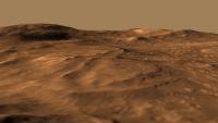
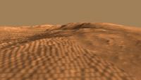
Late last week I stumbled upon a few HiRISE derived DEM's (Randy Kirk works his magic once again!)
http://webgis.wr.usgs.gov/ftphirise/index.jsp (URL now down) I'm working on both Vic Crater and the Columbia Hills. Fortunately, now I've got a Mac, I can use ISIS. I've figured out a fairly simple flow ( isis2raw as 16 bit unsigned, and then imported into Photoshop ) to take DEM CUB's and make 16 bit PNG's  Just to demo how important that is for me as an animator - sliced comparisons of 8bit vs 16 bit. A busy week unfortunately, but animations of various sorts are in the pipeline.
Attached thumbnail(s)
|
||
 |
 
|
||
 |
|
May 19 2008, 04:12 PM
Post
#2
|
|
|
Founder Group: Chairman Posts: 14434 Joined: 8-February 04 Member No.: 1 |
|
|
|
|
|
May 19 2008, 09:19 PM
Post
#3
|
||
 Member Group: Members Posts: 213 Joined: 21-January 07 From: Wigan, England Member No.: 1638 |
QUOTE (djellison @ May 19 2008, 05:12 PM)  Ah, I knew that was one of yours, yet when I checked APOD this morning (10:00), your name wasn't in the credit line (which I thought was a bit out of order).
|
|
|
|
|
|
 djellison HiRISE DEM's Apr 13 2008, 10:46 AM
 Bjorn Jonsson QUOTE (djellison @ Apr 13 2008, 10:46 AM)... Apr 13 2008, 10:15 PM djellison Still figuring out the best way to explore and dis... Apr 14 2008, 10:41 AM djellison And using the Victoria one to simulate shadowing w... Apr 15 2008, 07:33 AM djellison I've had a hard time trying to do justice to t... Apr 20 2008, 07:30 PM djellison And Victoria crater
http://www.unmannedspacefligh... Apr 21 2008, 09:04 AM Stu Cooler than a penguin sat on an iceberg, sucking a... Apr 21 2008, 01:07 PM ilbasso Agree, very very cool!
All that's needed ... Apr 21 2008, 05:27 PM djellison I rendered a jumbo 4kx4k fisheye then polar-to-rec... May 5 2008, 01:14 PM djellison I hope you all enjoyed the movies at full res cour... May 15 2008, 11:24 AM Stu Well done! About time your work on these DEMs ... May 19 2008, 04:20 PM
Bjorn Jonsson QUOTE (djellison @ Apr 13 2008, 10:46 AM)... Apr 13 2008, 10:15 PM djellison Still figuring out the best way to explore and dis... Apr 14 2008, 10:41 AM djellison And using the Victoria one to simulate shadowing w... Apr 15 2008, 07:33 AM djellison I've had a hard time trying to do justice to t... Apr 20 2008, 07:30 PM djellison And Victoria crater
http://www.unmannedspacefligh... Apr 21 2008, 09:04 AM Stu Cooler than a penguin sat on an iceberg, sucking a... Apr 21 2008, 01:07 PM ilbasso Agree, very very cool!
All that's needed ... Apr 21 2008, 05:27 PM djellison I rendered a jumbo 4kx4k fisheye then polar-to-rec... May 5 2008, 01:14 PM djellison I hope you all enjoyed the movies at full res cour... May 15 2008, 11:24 AM Stu Well done! About time your work on these DEMs ... May 19 2008, 04:20 PM
 ustrax Magnifique! May 19 2008, 04:50 PM nprev Bra-VO!!! Superbly rendered...and a... May 19 2008, 05:05 PM djellison Just for fun, I actually have a better version on ... May 19 2008, 05:09 PM john_s These are great- nice job Doug!
I'm still... May 19 2008, 05:31 PM djellison Well - there are four done for various Phoenix sit... May 19 2008, 05:38 PM dilo Congrats, Doug!
Unfortunately, the movie is al... May 19 2008, 07:38 PM climber QUOTE (dilo @ May 19 2008, 09:38 PM) Unfo... May 20 2008, 07:31 AM climber Your work put everything in a new perspective and ... May 19 2008, 07:34 PM ngunn I thoroughly enjoyed seeing these on TPS - why did... May 19 2008, 08:03 PM djellison The cliffs are a bit rounded off, just a symptom o... May 19 2008, 08:37 PM dilo QUOTE (djellison @ May 19 2008, 08:37 PM)... May 20 2008, 06:36 AM djellison QUOTE (dilo @ May 20 2008, 07:36 AM) I th... May 20 2008, 06:58 AM dilo Doug, I perfectly understand the issue you describ... May 21 2008, 10:26 AM djellison QUOTE (dilo @ May 21 2008, 11:26 AM) What... May 21 2008, 10:42 AM mhoward QUOTE (djellison @ May 21 2008, 04:42 AM)... May 21 2008, 12:04 PM Kevin QUOTE (djellison @ May 21 2008, 03:42 AM)... Jun 15 2008, 04:14 PM djellison I didn't know it had been posted on there. I ... May 19 2008, 10:14 PM djellison Finished thing is now here : http://www.dougelliso... May 19 2008, 11:19 PM ElkGroveDan Not found May 19 2008, 11:34 PM nprev Yeah, went hunting myself...no joy.
Did enjoy ... May 19 2008, 11:48 PM djellison I prepared this for someone else - thought forum p... Oct 13 2008, 09:18 PM thare For those that don't want to or can't inst... Nov 13 2008, 05:14 AM djellison Gale Crater dem up
http://www.dougellison.com/?p... Oct 19 2008, 06:02 PM mhoward OK, now that's cool. Oct 19 2008, 06:51 PM djellison Doing an updated 2009 version of my Columbia Hills... Sep 21 2009, 10:13 PM djellison FINISHED
http://www.dougellison.com/?p=82
Not p... Sep 22 2009, 08:13 PM Roby72 Like flying around - brilliant !
Robert Sep 22 2009, 08:54 PM elakdawalla Love the dusty quality of the atmosphere. An easy... Sep 22 2009, 09:22 PM PDP8E Hi Doug,
unbelievable job on the fly around! ... Sep 22 2009, 09:34 PM remcook I love how Spirit appears suddenly behind Home Pla... Sep 23 2009, 07:13 AM imipak Superb. Sep 23 2009, 08:15 AM antipode on Mars, on Mars, on Mars...
Thankyou.
p Sep 24 2009, 08:04 AM Stu QUOTE (antipode @ Sep 24 2009, 09:04 AM) ... Sep 24 2009, 01:40 PM ustrax Doug, that's just...beautiful. With all the be... Sep 24 2009, 02:19 PM climber I knew you were not going to sent the MER team ... Sep 24 2009, 04:38 PM JRA Great animation djellison. I really like it a lot.... Sep 25 2009, 02:50 AM elakdawalla I haven't tried to work with the DEM data at a... Sep 25 2009, 04:06 AM JRA The file is 16-bit. And the histogram seems to be ... Sep 25 2009, 04:16 AM elakdawalla Well that's pretty much all my ideas. Guess y... Sep 25 2009, 04:32 AM djellison This is the only way I know - so far - and it... Sep 25 2009, 07:33 AM djellison 1080 Full HD version
http://www.archive.org/detail... Sep 25 2009, 02:45 PM PhilCo126 Superb work Doug, it didn't go unnoticed on ot... Sep 25 2009, 04:57 PM djellison Nancy talked about it on Universe Today, Emily did... Sep 25 2009, 05:05 PM SFJCody Beautiful work as ever. Sep 25 2009, 06:53 PM stevesliva QUOTE (djellison @ Sep 25 2009, 12:05 PM)... Oct 3 2009, 05:44 AM tharrison NASA Ames is working on a stereo pipeline for auto... Jan 10 2010, 11:10 PM Zack Moratto QUOTE (tharrison @ Jan 10 2010, 03:10 PM)... Jan 24 2010, 08:11 AM tharrison QUOTE (Zack Moratto @ Jan 24 2010, 12:11 ... Jan 24 2010, 07:45 PM Zack Moratto Okay fine. I'll bug Trent next week when I see... Jan 25 2010, 05:53 AM tharrison Trent got in touch with our software folks this mo... Jan 25 2010, 06:26 PM elakdawalla Is this news?
First PDS Release of HiRISE DTMs
D... Jan 21 2010, 02:35 AM Nirgal QUOTE (elakdawalla @ Jan 21 2010, 03:35 A... Jan 21 2010, 01:29 PM ElkGroveDan If you view any of those fly-overs, be sure and se... Jan 21 2010, 03:02 PM charborob Not having the knowledge nor the time to make use ... Jan 21 2010, 04:50 PM djellison I've picked four favorites from the new batch ... Jan 24 2010, 10:16 AM djellison The results of processing the new HiRISE team DEM... Jan 27 2010, 03:36 PM Nirgal QUOTE (djellison @ Jan 27 2010, 04:36 PM)... Jan 27 2010, 10:21 PM Vultur Interesting how there's a crater right on top ... Jan 27 2010, 04:11 PM remcook Still pretty wow ! Jan 27 2010, 04:31 PM elakdawalla Wow there's a lot of texture in those DEMs... Jan 27 2010, 05:22 PM Mars3D Here's a couple of images created from the new... Jan 27 2010, 06:04 PM djellison It's done in the renderer as required by each ... Jan 27 2010, 10:42 PM Bjorn Jonsson QUOTE (djellison @ Jan 27 2010, 10:42 PM)... Jan 28 2010, 01:29 AM nprev Man, am I glad I finally got a new computer for Ch... Jan 27 2010, 10:43 PM djellison Update : - Gale Crater uploaded
http://www.youtube... Jan 27 2010, 10:52 PM The Singing Badger Dude, you made it onto the Huffington Post!
h... Jan 27 2010, 11:18 PM belleraphon1 TOTALLY AWESOME.
Gold standard Forum this is... Jan 28 2010, 12:49 AM djellison I think it's being selective in not generating... Jan 28 2010, 07:28 AM charborob Its interesting to compare Doug's Mojave crate... Jan 28 2010, 02:33 PM djellison Interesting in what way Good/bad/indiferent Jan 28 2010, 06:08 PM helvick I prefer your lighting, and you have a better flig... Jan 28 2010, 07:46 PM charborob Doug, your animations are great. The flyover on th... Jan 28 2010, 08:38 PM djellison Two more - http://www.youtube.com/watch?v=wswCRehr... Jan 29 2010, 07:17 PM pgrindrod they are sweet doug - well done!
take a break... Jan 29 2010, 07:54 PM climber I believe I can fly.
Thanks Doug. Jan 29 2010, 08:16 PM Poolio Finally got the chance to watch these full screen ... Jan 30 2010, 07:23 PM djellison Just getting the data that Pete helped me make (in... Feb 1 2010, 02:35 PM elakdawalla I'd amend that to
early results = awesome... Feb 1 2010, 05:47 PM charborob If this is only "early results", I can... Feb 1 2010, 06:10 PM djellison It's rendering now. Start with Pathfinder pan... Feb 1 2010, 06:16 PM djellison Time for DEM hatrick....
One of Pete Grindrod... Feb 2 2010, 11:23 AM charborob Fantastic animations! Congratulations, Doug... Feb 2 2010, 02:11 PM ElkGroveDan Go ahead and take the rest of the week off Doug an... Feb 2 2010, 02:38 PM djellison When I first popped the pathfinder pan back over t... Feb 2 2010, 02:49 PM hendric Doug,
Simply amazing. When you redo this one, c... Feb 2 2010, 03:36 PM djellison I'm doing a MAJOR 2.0 that's quite differe... Feb 2 2010, 04:24 PM eoincampbell For some reason only Quicktime wants to play it sm... Feb 2 2010, 06:23 PM
ustrax Magnifique! May 19 2008, 04:50 PM nprev Bra-VO!!! Superbly rendered...and a... May 19 2008, 05:05 PM djellison Just for fun, I actually have a better version on ... May 19 2008, 05:09 PM john_s These are great- nice job Doug!
I'm still... May 19 2008, 05:31 PM djellison Well - there are four done for various Phoenix sit... May 19 2008, 05:38 PM dilo Congrats, Doug!
Unfortunately, the movie is al... May 19 2008, 07:38 PM climber QUOTE (dilo @ May 19 2008, 09:38 PM) Unfo... May 20 2008, 07:31 AM climber Your work put everything in a new perspective and ... May 19 2008, 07:34 PM ngunn I thoroughly enjoyed seeing these on TPS - why did... May 19 2008, 08:03 PM djellison The cliffs are a bit rounded off, just a symptom o... May 19 2008, 08:37 PM dilo QUOTE (djellison @ May 19 2008, 08:37 PM)... May 20 2008, 06:36 AM djellison QUOTE (dilo @ May 20 2008, 07:36 AM) I th... May 20 2008, 06:58 AM dilo Doug, I perfectly understand the issue you describ... May 21 2008, 10:26 AM djellison QUOTE (dilo @ May 21 2008, 11:26 AM) What... May 21 2008, 10:42 AM mhoward QUOTE (djellison @ May 21 2008, 04:42 AM)... May 21 2008, 12:04 PM Kevin QUOTE (djellison @ May 21 2008, 03:42 AM)... Jun 15 2008, 04:14 PM djellison I didn't know it had been posted on there. I ... May 19 2008, 10:14 PM djellison Finished thing is now here : http://www.dougelliso... May 19 2008, 11:19 PM ElkGroveDan Not found May 19 2008, 11:34 PM nprev Yeah, went hunting myself...no joy.
Did enjoy ... May 19 2008, 11:48 PM djellison I prepared this for someone else - thought forum p... Oct 13 2008, 09:18 PM thare For those that don't want to or can't inst... Nov 13 2008, 05:14 AM djellison Gale Crater dem up
http://www.dougellison.com/?p... Oct 19 2008, 06:02 PM mhoward OK, now that's cool. Oct 19 2008, 06:51 PM djellison Doing an updated 2009 version of my Columbia Hills... Sep 21 2009, 10:13 PM djellison FINISHED
http://www.dougellison.com/?p=82
Not p... Sep 22 2009, 08:13 PM Roby72 Like flying around - brilliant !
Robert Sep 22 2009, 08:54 PM elakdawalla Love the dusty quality of the atmosphere. An easy... Sep 22 2009, 09:22 PM PDP8E Hi Doug,
unbelievable job on the fly around! ... Sep 22 2009, 09:34 PM remcook I love how Spirit appears suddenly behind Home Pla... Sep 23 2009, 07:13 AM imipak Superb. Sep 23 2009, 08:15 AM antipode on Mars, on Mars, on Mars...
Thankyou.
p Sep 24 2009, 08:04 AM Stu QUOTE (antipode @ Sep 24 2009, 09:04 AM) ... Sep 24 2009, 01:40 PM ustrax Doug, that's just...beautiful. With all the be... Sep 24 2009, 02:19 PM climber I knew you were not going to sent the MER team ... Sep 24 2009, 04:38 PM JRA Great animation djellison. I really like it a lot.... Sep 25 2009, 02:50 AM elakdawalla I haven't tried to work with the DEM data at a... Sep 25 2009, 04:06 AM JRA The file is 16-bit. And the histogram seems to be ... Sep 25 2009, 04:16 AM elakdawalla Well that's pretty much all my ideas. Guess y... Sep 25 2009, 04:32 AM djellison This is the only way I know - so far - and it... Sep 25 2009, 07:33 AM djellison 1080 Full HD version
http://www.archive.org/detail... Sep 25 2009, 02:45 PM PhilCo126 Superb work Doug, it didn't go unnoticed on ot... Sep 25 2009, 04:57 PM djellison Nancy talked about it on Universe Today, Emily did... Sep 25 2009, 05:05 PM SFJCody Beautiful work as ever. Sep 25 2009, 06:53 PM stevesliva QUOTE (djellison @ Sep 25 2009, 12:05 PM)... Oct 3 2009, 05:44 AM tharrison NASA Ames is working on a stereo pipeline for auto... Jan 10 2010, 11:10 PM Zack Moratto QUOTE (tharrison @ Jan 10 2010, 03:10 PM)... Jan 24 2010, 08:11 AM tharrison QUOTE (Zack Moratto @ Jan 24 2010, 12:11 ... Jan 24 2010, 07:45 PM Zack Moratto Okay fine. I'll bug Trent next week when I see... Jan 25 2010, 05:53 AM tharrison Trent got in touch with our software folks this mo... Jan 25 2010, 06:26 PM elakdawalla Is this news?
First PDS Release of HiRISE DTMs
D... Jan 21 2010, 02:35 AM Nirgal QUOTE (elakdawalla @ Jan 21 2010, 03:35 A... Jan 21 2010, 01:29 PM ElkGroveDan If you view any of those fly-overs, be sure and se... Jan 21 2010, 03:02 PM charborob Not having the knowledge nor the time to make use ... Jan 21 2010, 04:50 PM djellison I've picked four favorites from the new batch ... Jan 24 2010, 10:16 AM djellison The results of processing the new HiRISE team DEM... Jan 27 2010, 03:36 PM Nirgal QUOTE (djellison @ Jan 27 2010, 04:36 PM)... Jan 27 2010, 10:21 PM Vultur Interesting how there's a crater right on top ... Jan 27 2010, 04:11 PM remcook Still pretty wow ! Jan 27 2010, 04:31 PM elakdawalla Wow there's a lot of texture in those DEMs... Jan 27 2010, 05:22 PM Mars3D Here's a couple of images created from the new... Jan 27 2010, 06:04 PM djellison It's done in the renderer as required by each ... Jan 27 2010, 10:42 PM Bjorn Jonsson QUOTE (djellison @ Jan 27 2010, 10:42 PM)... Jan 28 2010, 01:29 AM nprev Man, am I glad I finally got a new computer for Ch... Jan 27 2010, 10:43 PM djellison Update : - Gale Crater uploaded
http://www.youtube... Jan 27 2010, 10:52 PM The Singing Badger Dude, you made it onto the Huffington Post!
h... Jan 27 2010, 11:18 PM belleraphon1 TOTALLY AWESOME.
Gold standard Forum this is... Jan 28 2010, 12:49 AM djellison I think it's being selective in not generating... Jan 28 2010, 07:28 AM charborob Its interesting to compare Doug's Mojave crate... Jan 28 2010, 02:33 PM djellison Interesting in what way Good/bad/indiferent Jan 28 2010, 06:08 PM helvick I prefer your lighting, and you have a better flig... Jan 28 2010, 07:46 PM charborob Doug, your animations are great. The flyover on th... Jan 28 2010, 08:38 PM djellison Two more - http://www.youtube.com/watch?v=wswCRehr... Jan 29 2010, 07:17 PM pgrindrod they are sweet doug - well done!
take a break... Jan 29 2010, 07:54 PM climber I believe I can fly.
Thanks Doug. Jan 29 2010, 08:16 PM Poolio Finally got the chance to watch these full screen ... Jan 30 2010, 07:23 PM djellison Just getting the data that Pete helped me make (in... Feb 1 2010, 02:35 PM elakdawalla I'd amend that to
early results = awesome... Feb 1 2010, 05:47 PM charborob If this is only "early results", I can... Feb 1 2010, 06:10 PM djellison It's rendering now. Start with Pathfinder pan... Feb 1 2010, 06:16 PM djellison Time for DEM hatrick....
One of Pete Grindrod... Feb 2 2010, 11:23 AM charborob Fantastic animations! Congratulations, Doug... Feb 2 2010, 02:11 PM ElkGroveDan Go ahead and take the rest of the week off Doug an... Feb 2 2010, 02:38 PM djellison When I first popped the pathfinder pan back over t... Feb 2 2010, 02:49 PM hendric Doug,
Simply amazing. When you redo this one, c... Feb 2 2010, 03:36 PM djellison I'm doing a MAJOR 2.0 that's quite differe... Feb 2 2010, 04:24 PM eoincampbell For some reason only Quicktime wants to play it sm... Feb 2 2010, 06:23 PM |

|
Lo-Fi Version | Time is now: 27th September 2024 - 06:47 AM |
|
RULES AND GUIDELINES Please read the Forum Rules and Guidelines before posting. IMAGE COPYRIGHT |
OPINIONS AND MODERATION Opinions expressed on UnmannedSpaceflight.com are those of the individual posters and do not necessarily reflect the opinions of UnmannedSpaceflight.com or The Planetary Society. The all-volunteer UnmannedSpaceflight.com moderation team is wholly independent of The Planetary Society. The Planetary Society has no influence over decisions made by the UnmannedSpaceflight.com moderators. |
SUPPORT THE FORUM Unmannedspaceflight.com is funded by the Planetary Society. Please consider supporting our work and many other projects by donating to the Society or becoming a member. |
|